Harmony, Wisconsin
Submit your own pictures of this town and show them to the world
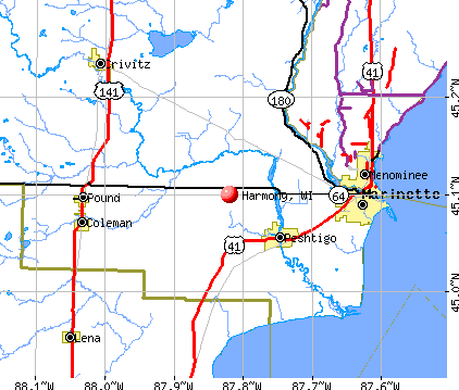
- OSM Map
- General Map
- Google Map
- MSN Map
Population change since 2000: +9.3%
| Males: 1,307 | |
| Females: 1,262 |
| Median resident age: | 42.7 years |
| Wisconsin median age: | 42.6 years |
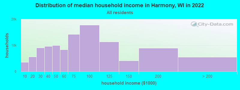
| Harmony: | $106,826 |
| WI: | $70,996 |
Estimated per capita income in 2022: $42,228 (it was $25,244 in 2000)
Harmony town income, earnings, and wages data
Estimated median house or condo value in 2022: $319,227 (it was $149,500 in 2000)
| Harmony: | $319,227 |
| WI: | $252,800 |
Mean prices in 2022: all housing units: $238,082; detached houses: $245,053; townhouses or other attached units: $203,498; in 2-unit structures: $189,869; in 3-to-4-unit structures: $159,516; in 5-or-more-unit structures: $150,313; mobile homes: $51,766
Detailed information about poverty and poor residents in Harmony, WI
Compare current foreclosures near Harmony, WI:
| Photo | Address | Area | Beds / Baths | Price | Details |
|---|---|---|---|---|---|

|
#1
Fox Hills Ct
Janesville, WI 53546
|
1,804 sq. feet
|
2 baths 3 beds |
$186,200
|
show details |

|
#2
W Hanover Rd
Janesville, WI 53548
|
- sq. feet
|
2 baths 4 beds |
$197,600
|
show details |

|
#3
N River Rd
Janesville, WI 53545
|
1,669 sq. feet
|
2 baths 4 beds |
show details | |

|
#4
Greendale Ct
Janesville, WI 53546
|
1,196 sq. feet
|
1 baths 3 beds |
show details | |

|
#5
Woodruff Blvd
Janesville, WI 53548
|
1,556 sq. feet
|
2 baths 3 beds |
show details | |

|
#6
Red Apple Dr
Janesville, WI 53548
|
1,545 sq. feet
|
3 baths 4 beds |
show details | |

|
#7
Norwood Rd
Janesville, WI 53545
|
914 sq. feet
|
2 baths 4 beds |
show details | |

|
#8
Mayfair Dr
Janesville, WI 53545
|
1,052 sq. feet
|
2 baths 3 beds |
show details | |

|
#9
Ruger Ave
Janesville, WI 53546
|
2,186 sq. feet
|
3 baths 3 beds |
show details | |

|
#10
Wagner Dr
Clinton, WI 53525
|
- sq. feet
|
2 baths 3 beds |
show details |
| Photo | Address | Area | Beds / Baths | Price | Details |
|---|---|---|---|---|---|

|
#11
Sherman Ave
Janesville, WI 53545
|
1,006 sq. feet
|
1 baths 2 beds |
show details | |

|
#12
S Crosby Ave
Janesville, WI 53548
|
720 sq. feet
|
1 baths 2 beds |
show details | |

|
#13
Parkview Dr
Milton, WI 53563
|
- sq. feet
|
2 baths 4 beds |
show details | |

|
#14
Yuba St
Janesville, WI 53545
|
1,784 sq. feet
|
1 baths 4 beds |
show details | |

|
#15
Glen St
Janesville, WI 53545
|
1,970 sq. feet
|
1 baths 4 beds |
show details | |

|
#16
Walker St
Janesville, WI 53545
|
1,152 sq. feet
|
1 baths 4 beds |
show details | |

|
#17
Center Ave
Janesville, WI 53546
|
1,200 sq. feet
|
1 baths 3 beds |
show details | |

|
#18
N Crosby Ave
Janesville, WI 53548
|
1,992 sq. feet
|
2 baths 3 beds |
show details | |

|
#19
S Main St
Janesville, WI 53545
|
2,335 sq. feet
|
1 baths 5 beds |
show details | |

|
#20
S Washington St
Janesville, WI 53546
|
2,560 sq. feet
|
2 baths 6 beds |
show details |
| Photo | Address | Area | Beds / Baths | Price | Details |
|---|---|---|---|---|---|

|
#21
Roosevelt Ave
Janesville, WI 53546
|
1,056 sq. feet
|
1 baths 3 beds |
show details | |

|
#22
Bond Pl
Janesville, WI 53548
|
1,444 sq. feet
|
2 baths 3 beds |
show details | |

|
#23
N Grant Ave
Janesville, WI 53548
|
1,180 sq. feet
|
1 baths 3 beds |
show details | |

|
#24
N Washington St
Janesville, WI 53548
|
864 sq. feet
|
1 baths 2 beds |
show details | |

|
#25
Jerome Ave
Janesville, WI 53546
|
1,148 sq. feet
|
2 baths 3 beds |
show details | |

|
#26
Briar Crest Dr
Janesville, WI 53546
|
1,670 sq. feet
|
2 baths 3 beds |
show details | |

|
#27
Elizabeth St
Janesville, WI 53548
|
2,100 sq. feet
|
1 baths 4 beds |
show details | |

|
#28
Gartland Ave
Janesville, WI 53548
|
1,078 sq. feet
|
1 baths 2 beds |
show details | |

|
#29
N Chatham St
Janesville, WI 53548
|
1,827 sq. feet
|
1 baths 4 beds |
show details | |

|
#30
N Chatham St
Janesville, WI 53548
|
740 sq. feet
|
1 baths 2 beds |
show details |
| Photo | Address | Area | Beds / Baths | Price | Details |
|---|---|---|---|---|---|

|
#31
Riverside St
Janesville, WI 53548
|
1,320 sq. feet
|
1 baths 4 beds |
show details | |

|
#32
Rockport Rd
Janesville, WI 53548
|
1,157 sq. feet
|
1 baths 3 beds |
show details | |

|
#33
N Walnut St
Janesville, WI 53548
|
1,230 sq. feet
|
1 baths 3 beds |
show details | |

|
#34
N Terrace St
Janesville, WI 53548
|
1,344 sq. feet
|
2 baths 4 beds |
show details | |

|
#35
Mineral Point Ave
Janesville, WI 53548
|
1,296 sq. feet
|
1 baths 3 beds |
show details | |

|
#36
N Walnut St
Janesville, WI 53548
|
1,014 sq. feet
|
1 baths 3 beds |
show details | |

|
#37
Garden Dr
Janesville, WI 53546
|
1,352 sq. feet
|
3 baths 3 beds |
show details | |

|
#38
Spruce St
Janesville, WI 53546
|
1,386 sq. feet
|
1 baths 4 beds |
show details | |

|
#39
Garden Dr
Janesville, WI 53546
|
1,014 sq. feet
|
2 baths 3 beds |
show details | |

|
#40
Roosevelt Ave
Janesville, WI 53546
|
1,161 sq. feet
|
1 baths 3 beds |
show details |
| Photo | Address | Area | Beds / Baths | Price | Details |
|---|---|---|---|---|---|

|
#41
W Burbank Ave
Janesville, WI 53546
|
1,318 sq. feet
|
2 baths 3 beds |
show details | |

|
#42
Morningside Dr
Janesville, WI 53546
|
2,212 sq. feet
|
2 baths 3 beds |
show details | |

|
#43
S Oakhill Ave
Janesville, WI 53546
|
1,598 sq. feet
|
1 baths 4 beds |
show details | |

|
#44
Mount Zion Ave
Janesville, WI 53545
|
1,274 sq. feet
|
1 baths 3 beds |
show details | |

|
#45
Bordeaux Dr
Janesville, WI 53546
|
1,248 sq. feet
|
2 baths 2 beds |
show details | |

|
#46
King St
Janesville, WI 53546
|
905 sq. feet
|
1 baths 2 beds |
show details | |

|
#47
Pershing Pl
Janesville, WI 53546
|
960 sq. feet
|
1 baths 3 beds |
show details | |

|
#48
S Pearl St
Janesville, WI 53546
|
960 sq. feet
|
2 baths 2 beds |
show details | |

|
#49
Friendship Dr
Janesville, WI 53546
|
1,692 sq. feet
|
2 baths 4 beds |
show details | |

|
Check over 1 million property listings on Foreclosure.com!
|
browse all offers | |||

- 2,47996.5%White alone
- 471.8%Hispanic
- 210.8%Asian alone
- 170.7%Two or more races
- 40.2%Black alone
- 10.04%Other race alone
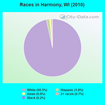
Races in Harmony detailed stats: ancestries, foreign born residents, place of birth
 Recent articles from our blog. Our writers, many of them Ph.D. graduates or candidates, create easy-to-read articles on a wide variety of topics.


 | Relocating-Janesville/Milton/Stoughton/Beloit??? (38 replies) |
| Moving back to Stevens Point? (3 replies) |
| Milwaukee Fire Department (81 replies) |
| Would you recommend Appleton? (87 replies) |
| Moving to Stevens Point, WI..... (14 replies) |
| Any laws, rules, etc. a newbie in Madison should know??? (75 replies) |
Latest news from Harmony, WI collected exclusively by city-data.com from local newspapers, TV, and radio stations
Ancestries: German (44.7%), Irish (18.6%), Norwegian (14.1%), English (13.3%), French (3.9%), United States (3.7%).
Current Local Time: CST time zone
Elevation: 695 feet
Land area: 24.0 square miles.
Population density: 107 people per square mile (very low).
17 residents are foreign born
| This town: | 0.7% |
| Wisconsin: | 3.6% |
| Harmony town: | 1.6% ($2,442) |
| Wisconsin: | 2.0% ($2,245) |
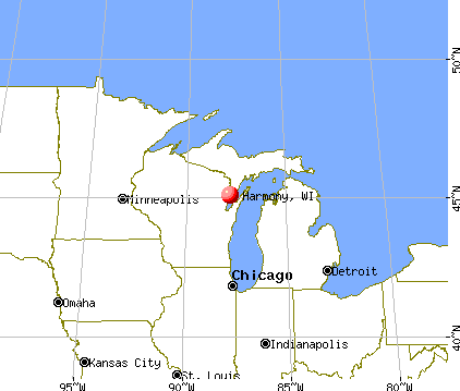
Nearest city with pop. 50,000+: Janesville, WI  (4.2 miles , pop. 59,498).
Nearest city with pop. 200,000+: Madison, WI (32.5 miles , pop. 208,054).
Nearest city with pop. 1,000,000+: Chicago, IL (89.9 miles , pop. 2,896,016).
Nearest cities:
), ), ), ), )Latitude: 42.73 N, Longitude: 88.96 W
Area code: 715

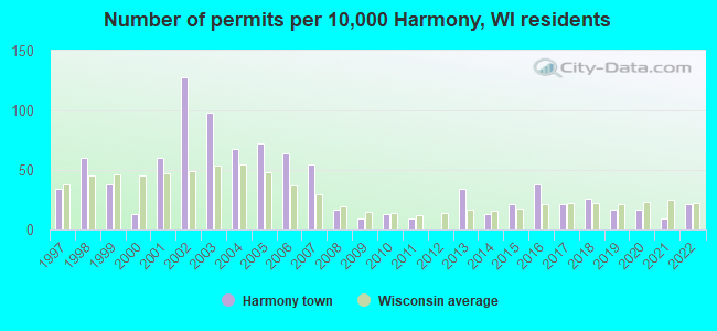
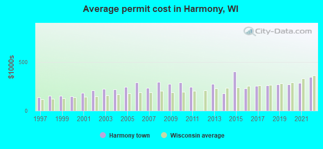
Single-family new house construction building permits:
- 2022: 5 buildings, average cost: $350,000
- 2021: 2 buildings, average cost: $285,000
- 2020: 4 buildings, average cost: $269,300
- 2019: 4 buildings, average cost: $270,700
- 2018: 6 buildings, average cost: $258,500
- 2017: 5 buildings, average cost: $255,600
- 2016: 9 buildings, average cost: $233,300
- 2015: 5 buildings, average cost: $403,500
- 2014: 3 buildings, average cost: $176,600
- 2013: 8 buildings, average cost: $275,300
- 2011: 2 buildings, average cost: $247,600
- 2010: 3 buildings, average cost: $290,000
- 2009: 2 buildings, average cost: $277,500
- 2008: 4 buildings, average cost: $295,000
- 2007: 13 buildings, average cost: $234,500
- 2006: 15 buildings, average cost: $293,000
- 2005: 17 buildings, average cost: $245,600
- 2004: 16 buildings, average cost: $218,700
- 2003: 23 buildings, average cost: $223,700
- 2002: 30 buildings, average cost: $209,000
- 2001: 14 buildings, average cost: $181,600
- 2000: 3 buildings, average cost: $148,000
- 1999: 9 buildings, average cost: $153,000
- 1998: 14 buildings, average cost: $155,700
- 1997: 8 buildings, average cost: $136,900
| Here: | 3.0% |
| Wisconsin: | 2.7% |
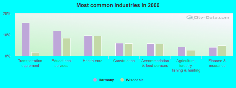
- Transportation equipment (15.7%)
- Educational services (11.8%)
- Health care (9.7%)
- Construction (6.1%)
- Accommodation & food services (5.9%)
- Agriculture, forestry, fishing & hunting (4.3%)
- Finance & insurance (4.2%)
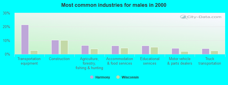
- Transportation equipment (21.5%)
- Construction (10.3%)
- Agriculture, forestry, fishing & hunting (6.5%)
- Accommodation & food services (6.2%)
- Educational services (6.2%)
- Motor vehicle & parts dealers (4.4%)
- Truck transportation (4.2%)
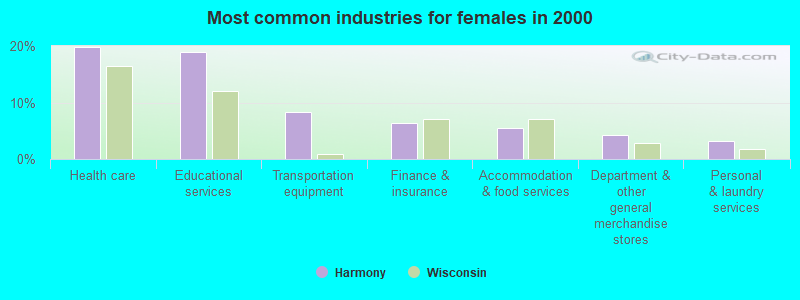
- Health care (19.9%)
- Educational services (19.0%)
- Transportation equipment (8.3%)
- Finance & insurance (6.3%)
- Accommodation & food services (5.4%)
- Department & other general merchandise stores (4.2%)
- Personal & laundry services (3.3%)
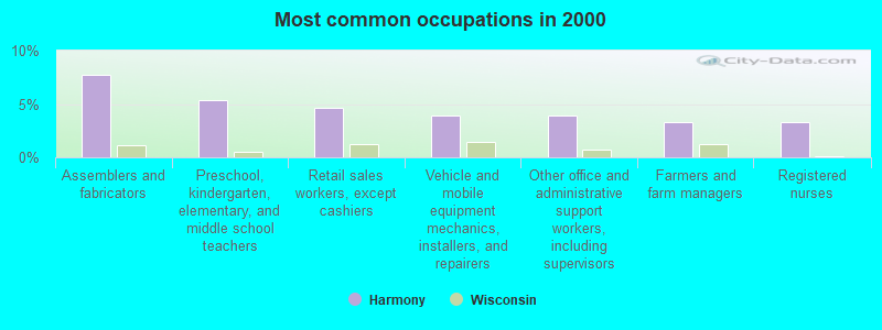
- Assemblers and fabricators (7.8%)
- Preschool, kindergarten, elementary, and middle school teachers (5.4%)
- Retail sales workers, except cashiers (4.6%)
- Vehicle and mobile equipment mechanics, installers, and repairers (3.9%)
- Other office and administrative support workers, including supervisors (3.9%)
- Farmers and farm managers (3.3%)
- Registered nurses (3.3%)
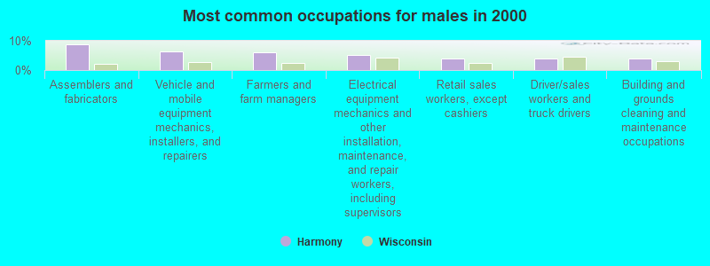
- Assemblers and fabricators (8.9%)
- Vehicle and mobile equipment mechanics, installers, and repairers (6.4%)
- Farmers and farm managers (5.9%)
- Electrical equipment mechanics and other installation, maintenance, and repair workers, including supervisors (5.1%)
- Retail sales workers, except cashiers (4.0%)
- Driver/sales workers and truck drivers (4.0%)
- Building and grounds cleaning and maintenance occupations (4.0%)
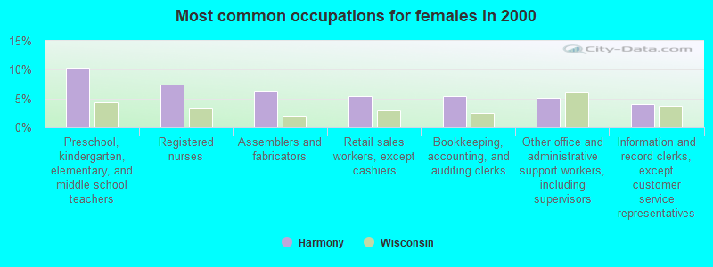
- Preschool, kindergarten, elementary, and middle school teachers (10.3%)
- Registered nurses (7.4%)
- Assemblers and fabricators (6.3%)
- Retail sales workers, except cashiers (5.4%)
- Bookkeeping, accounting, and auditing clerks (5.4%)
- Other office and administrative support workers, including supervisors (5.1%)
- Information and record clerks, except customer service representatives (4.0%)
Average climate in Harmony, Wisconsin
Based on data reported by over 4,000 weather stations


Tornado activity:
Harmony-area historical tornado activity is slightly above Wisconsin state average. It is 60% greater than the overall U.S. average.
On 1/24/1967, a category F3 (max. wind speeds 158-206 mph) tornado 2.6 miles away from the Harmony town center caused between $50,000 and $500,000 in damages.
On 6/7/1984, a category F5 (max. wind speeds 261-318 mph) tornado 47.5 miles away from the town center killed 9 people and injured 200 people and caused between $50,000 and $500,000 in damages.
Earthquake activity:
Harmony-area historical earthquake activity is significantly above Wisconsin state average. It is 39% greater than the overall U.S. average.On 4/18/2008 at 09:36:59, a magnitude 5.4 (5.1 MB, 4.8 MS, 5.4 MW, 5.2 MW, Class: Moderate, Intensity: VI - VII) earthquake occurred 301.1 miles away from the city center
On 6/28/2004 at 06:10:52, a magnitude 4.2 (4.2 MW, Depth: 6.2 mi, Class: Light, Intensity: IV - V) earthquake occurred 87.8 miles away from the city center
On 6/10/1987 at 23:48:54, a magnitude 5.1 (4.9 MB, 4.4 MS, 4.6 MS, 5.1 LG) earthquake occurred 276.1 miles away from the city center
On 4/18/2008 at 09:36:59, a magnitude 5.2 (5.2 MW, Depth: 8.9 mi) earthquake occurred 301.2 miles away from Harmony center
On 2/10/2010 at 09:59:35, a magnitude 3.8 (3.8 MW, Depth: 6.2 mi, Class: Light, Intensity: II - III) earthquake occurred 57.6 miles away from the city center
On 5/2/2015 at 16:23:07, a magnitude 4.2 (4.2 MW, Depth: 2.8 mi) earthquake occurred 183.4 miles away from Harmony center
Magnitude types: regional Lg-wave magnitude (LG), body-wave magnitude (MB), surface-wave magnitude (MS), moment magnitude (MW)
Natural disasters:
The number of natural disasters in Rock County (14) is near the US average (15).Major Disasters (Presidential) Declared: 10
Emergencies Declared: 4
Causes of natural disasters: Floods: 9, Storms: 9, Tornadoes: 4, Drought: 1, Hurricane: 1, Snow: 1, Wind: 1, Winter Storm: 1, Other: 1 (Note: some incidents may be assigned to more than one category).

Hospitals and medical centers near Harmony:
- HOSPICE TEAM CARE INC (Hospital, about 4 miles away; JANESVILLE, WI)
- DAVITA - JANESVILLE (Dialysis Facility, about 4 miles away; JANESVILLE, WI)
- ROCK COUNTY HEALTH CTR (Nursing Home, about 4 miles away; JANESVILLE, WI)
- ST ELIZABETH NURSING HOME (Nursing Home, about 5 miles away; JANESVILLE, WI)
- JANESVILLE HEALTH CARE CENTER (Nursing Home, about 5 miles away; JANESVILLE, WI)
- MERCY ASSISTED CARE (Home Health Center, about 5 miles away; JANESVILLE, WI)
- MERCY REGIONAL DIALYSIS CENTER (Dialysis Facility, about 5 miles away; JANESVILLE, WI)
Amtrak stations near Harmony:
- 2 miles: JANESVILLE (HWY. 26 & HWY. 14) - Bus Station . Services: enclosed waiting area, public restrooms, public payphones, paid short-term parking, paid long-term parking, call for taxi service, public transit connection.
- 5 miles: JANESVILLE (3136 EAST COUNTY ROAD O)
- 17 miles: BELOIT (HWY. 75 & HWY. 51) - Bus Station . Services: call for taxi service.
Colleges/universities with over 2000 students nearest to Harmony:
- University of Wisconsin-Whitewater (about 14 miles; Whitewater, WI; Full-time enrollment: 11,124)
- Rock Valley College (about 30 miles; Rockford, IL; FT enrollment: 6,269)
- Edgewood College (about 33 miles; Madison, WI; FT enrollment: 2,455)
- University of Wisconsin Colleges (about 33 miles; Madison, WI; FT enrollment: 10,019)
- University of Wisconsin-Madison (about 33 miles; Madison, WI; FT enrollment: 34,621)
- Madison Area Technical College (about 33 miles; Madison, WI; FT enrollment: 9,603)
- Herzing University-Madison (about 34 miles; Madison, WI; FT enrollment: 3,160)
Points of interest:
Notable locations in Harmony: Camp Rotamer (A), That Tree Farm (B). Display/hide their locations on the map
Cemetery: Mount Zion Cemetery (1). Display/hide its location on the map
Lake: Spauldings Pond (A). Display/hide its location on the map
Park in Harmony: Saturn Park (1). Display/hide its location on the map
| This town: | 2.8 people |
| Wisconsin: | 2.4 people |
| This town: | 85.2% |
| Whole state: | 64.4% |
| This town: | 5.2% |
| Whole state: | 7.3% |
Likely homosexual households (counted as self-reported same-sex unmarried-partner households)
- Lesbian couples: 0.3% of all households
- Gay men: 0.2% of all households
| This town: | 0.7% |
| Whole state: | 8.7% |
| This town: | 0.2% |
| Whole state: | 3.7% |
For population 15 years and over in Harmony:
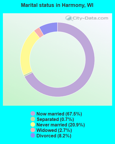
- Never married: 20.9%
- Now married: 67.5%
- Separated: 0.7%
- Widowed: 2.7%
- Divorced: 8.2%
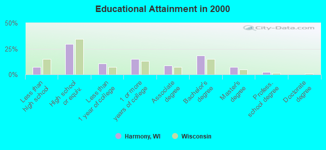
For population 25 years and over in Harmony:
- High school or higher: 92.5%
- Bachelor's degree or higher: 28.2%
- Graduate or professional degree: 9.6%
- Unemployed: 2.2%
- Mean travel time to work (commute): 20.1 minutes
| Here: | 9.2 |
| Wisconsin average: | 11.0 |
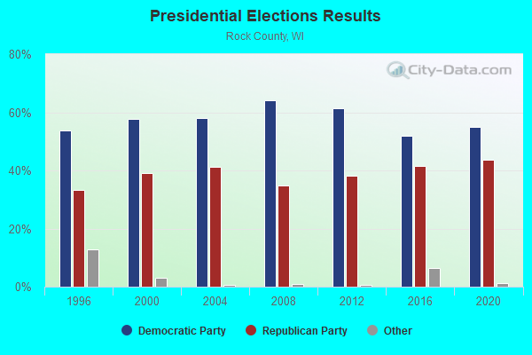
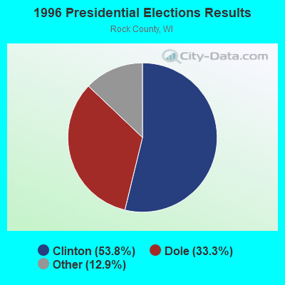

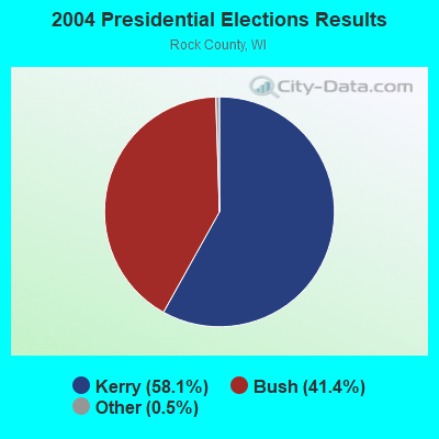
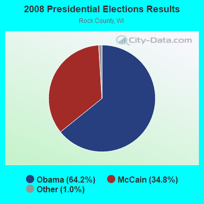
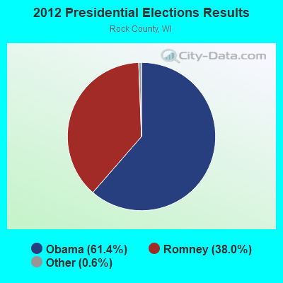
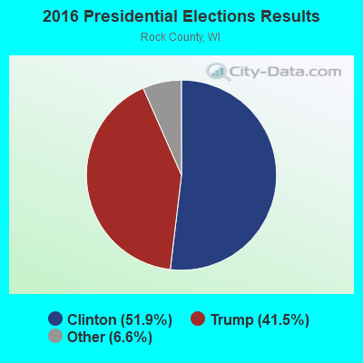
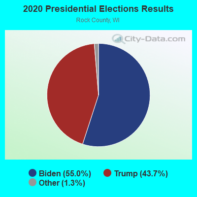
Graphs represent county-level data. Detailed 2008 Election Results
Religion statistics for Harmony, WI (based on Rock County data)
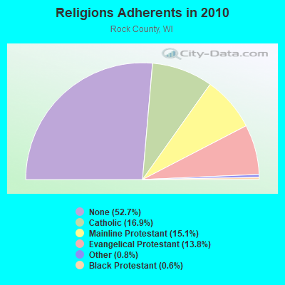
| Religion | Adherents | Congregations |
|---|---|---|
| Catholic | 27,158 | 12 |
| Mainline Protestant | 24,208 | 48 |
| Evangelical Protestant | 22,177 | 80 |
| Other | 1,347 | 13 |
| Black Protestant | 941 | 4 |
| None | 84,500 | - |
Food Environment Statistics:
| Rock County: | 1.38 / 10,000 pop. |
| State: | 1.86 / 10,000 pop. |
| Here: | 0.13 / 10,000 pop. |
| State: | 0.11 / 10,000 pop. |
| This county: | 0.50 / 10,000 pop. |
| State: | 0.38 / 10,000 pop. |
| This county: | 4.08 / 10,000 pop. |
| Wisconsin: | 4.12 / 10,000 pop. |
| Rock County: | 8.16 / 10,000 pop. |
| State: | 8.64 / 10,000 pop. |
| Rock County: | 8.4% |
| Wisconsin: | 7.6% |
| Rock County: | 27.5% |
| Wisconsin: | 27.5% |
| This county: | 13.5% |
| Wisconsin: | 13.0% |
Strongest AM radio stations in Harmony:
- WTMJ (620 AM; 50 kW; MILWAUKEE, WI; Owner: JOURNAL BROADCAST CORPORATION)
- WISN (1130 AM; 50 kW; MILWAUKEE, WI; Owner: CAPSTAR TX LIMITED PARTNERSHIP)
- WCLO (1230 AM; 1 kW; JANESVILLE, WI; Owner: SOUTHERN WISCONSIN BROADCASTING, LLC.)
- WGN (720 AM; 50 kW; CHICAGO, IL; Owner: WGN CONTINENTAL BROADCASTING CO.)
- WTSO (1070 AM; 10 kW; MADISON, WI; Owner: CAPSTAR TX LIMITED PARTNERSHIP)
- WSCR (670 AM; 50 kW; CHICAGO, IL; Owner: INFINITY BROADCASTING OPERATIONS, INC.)
- WBBM (780 AM; 50 kW; CHICAGO, IL; Owner: INFINITY BROADCASTING OPERATIONS, INC.)
- WTJK (1380 AM; 5 kW; SOUTH BELOIT, IL; Owner: GOOD KARMA BROADCASTING, L.L.C.)
- WMVP (1000 AM; 50 kW; CHICAGO, IL; Owner: ABC, INC.)
- WLMV (1480 AM; 10 kW; MADISON, WI; Owner: MID-WEST MANAGEMENT, INC.)
- WTDY (1670 AM; 10 kW; MADISON, WI; Owner: MID-WEST MANAGEMENT, INC.)
- WLS (890 AM; 50 kW; CHICAGO, IL; Owner: WLS, INC.)
- WHA (970 AM; 5 kW; MADISON, WI; Owner: BOARD REGENTS OF UNIV OF WI SYSTEM)
Strongest FM radio stations in Harmony:
- WSJY (107.3 FM; FORT ATKINSON, WI; Owner: NEWRADIO GROUP, LLC)
- WJVL (99.9 FM; JANESVILLE, WI; Owner: SOUTHERN WISCONSIN BROADCASTING, L.L.C.)
- WKPO (105.9 FM; EVANSVILLE, WI; Owner: GOOD KARMA BROADCASTING, L.L.C.)
- WSLD (104.5 FM; WHITEWATER, WI; Owner: WPW BROADCASTING, INC.)
- WERN (88.7 FM; MADISON, WI; Owner: STATE OF WISCONSIN - EDUCATIONAL COMMUNICATIONS BOARD)
- WZEE (104.1 FM; MADISON, WI; Owner: CAPSTAR TX LIMITED PARTNERSHIP)
- WORT (89.9 FM; MADISON, WI; Owner: BACK PORCH RADIO BROADCASTING, INC.)
- WIBA-FM (101.5 FM; MADISON, WI; Owner: CAPSTAR TX LIMITED PARTNERSHIP)
- WJJO (94.1 FM; WATERTOWN, WI; Owner: MID-WEST MANAGMENT, INC.)
- WMGN (98.1 FM; MADISON, WI; Owner: MID-WEST MANAGEMENT, INC.)
- WFEN (88.3 FM; ROCKFORD, IL; Owner: FAITH ACADEMY, DBA WFEN)
- WKCH (106.5 FM; WHITEWATER, WI; Owner: NEWRADIO GROUP, LLC)
- WGFB (103.1 FM; ROCKTON, IL; Owner: WRWC, Inc.)
- WKMQ-FM (96.7 FM; LOVES PARK, IL; Owner: CUMULUS LICENSING CORP.)
- WGSL (91.1 FM; LOVES PARK, IL; Owner: CHRISTIAN LIFE CENTER SCHOOL)
- WHAD (90.7 FM; DELAFIELD, WI; Owner: STATE OF WISCONSIN - EDUCATIONAL COMMUNICATIONS BOARD)
- WMMM-FM (105.5 FM; VERONA, WI; Owner: ENTERCOM MADISON LICENSE, LLC.)
- WSUW (91.7 FM; WHITEWATER, WI; Owner: BD. OF REGENTS, UNIV. OF WIS.)
- WQFL (100.9 FM; ROCKFORD, IL; Owner: QUEST FOR LIFE, INC.)
- WXRX (104.9 FM; BELVIDERE, IL; Owner: AIRPLAY BROADCASTING CORP.)
TV broadcast stations around Harmony:
- W65EE (Channel 65; JANESVILLE, WI; Owner: TRINITY BROADCASTING NETWORK)
- WISC-TV (Channel 3; MADISON, WI; Owner: TELEVISION WISCONSIN, INC.)
- WMSN-TV (Channel 47; MADISON, WI; Owner: WMSN LICENSEE, LLC)
- WKOW-TV (Channel 27; MADISON, WI; Owner: WKOW TELEVISION, INC.)
- WHA-TV (Channel 21; MADISON, WI; Owner: BOARD OF REGENTS OF THE UNIV. OF WISCONSIN SYSTEM)
- WMTV (Channel 15; MADISON, WI; Owner: GRAY MIDAMERICA TV LICENSEE CORP.)
- WIFR (Channel 23; FREEPORT, IL; Owner: GRAY MIDAMERICA TV LICENSEE CORP.)
- WTVO (Channel 17; ROCKFORD, IL; Owner: WINNEBAGO TELEVISION CORPORATION)
- WFBN-LP (Channel 33; ROCKFORD, IL; Owner: WEIGEL BROADCASTING COMPANY)
- WQRF-TV (Channel 39; ROCKFORD, IL; Owner: QUORUM OF ROCKFORD LICENSE, LLC)
- WREX-TV (Channel 13; ROCKFORD, IL; Owner: WREX TELEVISION, LLC)
- National Bridge Inventory (NBI) Statistics
- 19Number of bridges
- 138ft / 42.2mTotal length
- $1,996,000Total costs
- 184,561Total average daily traffic
- 10,542Total average daily truck traffic
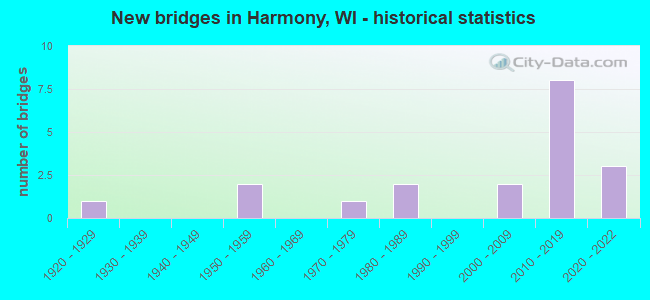
- New bridges - historical statistics
- 11920-1929
- 21950-1959
- 11970-1979
- 21980-1989
- 22000-2009
- 82010-2019
- 32020-2022
FCC Registered Cell Phone Towers:
1 (See the full list of FCC Registered Cell Phone Towers in Harmony)FCC Registered Antenna Towers:
11 (See the full list of FCC Registered Antenna Towers)FCC Registered Broadcast Land Mobile Towers:
2- N3561 Lepinski Lane (Lat: 45.086944 Lon: -87.912500), Type: Tower, Structure height: 91.4 m, Overall height: 97.5 m, Call Sign: KSF963,
Assigned Frequencies: 154.935 MHz, 155.505 MHz, 151.370 MHz, 151.460 MHz, 151.280 MHz, 151.460 MHz, 155.445 MHz, 155.475 MHz, Grant Date: 08/15/2023, Expiration Date: 09/09/2033, Certifier: Diane Miller, Registrant: Wisconsin State Patrol, 4822 Madison Yards Way - 9th Fl South, Madison, WI 53705, Phone: (608) 709-0095, Email:
- N3561 Lepinski Lane (Lat: 45.086944 Lon: -87.912500), Type: Ltower, Structure height: 91.4 m, Overall height: 97.5 m, Call Sign: WNUS531,
Assigned Frequencies: 151.145 MHz, 151.205 MHz, 151.310 MHz, 151.355 MHz, 159.225 MHz, 159.225 MHz, 159.255 MHz, 159.255 MHz, Grant Date: 07/29/2022, Expiration Date: 10/05/2032, Certifier: Thomas L Tuttle, Registrant: Wisconsin State Patrol, 4722 Madison Yards Way - 9th Fl South, Madison, WI 53705, Phone: (608) 709-0095, Email:
FCC Registered Microwave Towers:
2- 1100 Ft N & 100 Ft W Cor Joy Ln & Augustine Rd (Lat: 45.095528 Lon: -87.933417), Overall height: 67.1 m, Call Sign: WPNJ353,
Assigned Frequencies: 928.031 MHz, 952.031 MHz, Grant Date: 10/02/2012, Expiration Date: 12/10/2022, Cancellation Date: 04/06/2017,
- MARINETTE, N3561 Lepinski Lane (Lat: 45.086944 Lon: -87.912500), Type: Tower, Structure height: 91.4 m, Overall height: 97.5 m, Call Sign: WPP62,
Assigned Frequencies: 6695.00 MHz, 6665.00 MHz, 6625.00 MHz, Grant Date: 11/08/2019, Expiration Date: 12/15/2029, Registrant: Wisconsin State Patrol, 4822 Madison Yards Way - 9th Fl South, Madison, WI 53705, Phone: (608) 709-0095, Email:
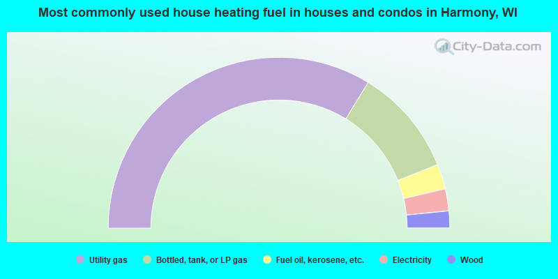
- 67.5%Utility gas
- 20.4%Bottled, tank, or LP gas
- 4.7%Fuel oil, kerosene, etc.
- 4.2%Electricity
- 3.2%Wood
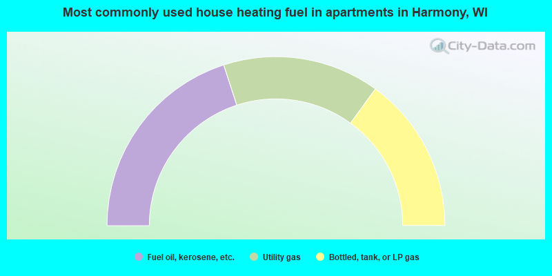
- 40.0%Fuel oil, kerosene, etc.
- 30.0%Utility gas
- 30.0%Bottled, tank, or LP gas
Harmony compared to Wisconsin state average:
- Median household income above state average.
- Unemployed percentage significantly below state average.
- Black race population percentage significantly below state average.
- Hispanic race population percentage significantly below state average.
- Foreign-born population percentage significantly below state average.
- Renting percentage significantly below state average.
- Length of stay since moving in significantly above state average.
- Number of rooms per house significantly below state average.
- House age significantly below state average.