Long Branch-Dotson, Texas
Submit your own pictures of this place and show them to the world
- OSM Map
- Google Map
- MSN Map
| Males: 1,184 | |
| Females: 1,214 |
| Median resident age: | 43.3 years |
| Texas median age: | 32.3 years |
Zip code: 75669
| Long Branch-Dotson: | $57,504 |
| TX: | $72,284 |
Estimated per capita income in 2022: $31,726 (it was $15,051 in 2000)
Long Branch-Dotson CCD income, earnings, and wages data
Estimated median house or condo value in 2022: $166,630 (it was $53,200 in 2000)
| Long Branch-Dotson: | $166,630 |
| TX: | $275,400 |
Mean prices in 2022: all housing units: $201,801; detached houses: $235,622; townhouses or other attached units: $159,811; mobile homes: $96,525; occupied boats, rvs, vans, etc.: $68,380
Long Branch-Dotson, TX residents, houses, and apartments details
Detailed information about poverty and poor residents in Long Branch-Dotson, TX


- 2,09088.2%White alone
- 2179.2%Black alone
- 331.4%Hispanic
- 210.9%Two or more races
- 80.3%American Indian alone
- 10.04%Asian alone

Races in Long Branch-Dotson detailed stats: ancestries, foreign born residents, place of birth
 Recent articles from our blog. Our writers, many of them Ph.D. graduates or candidates, create easy-to-read articles on a wide variety of topics.
Current Local Time: CST time zone
Land area: 109.5 square miles.
Population density: 22 people per square mile (very low).
| Long Branch-Dotson CCD: | 0.9% ($455) |
| Texas: | 1.8% ($1,393) |
Nearest city with pop. 50,000+: Longview, TX  (36.5 miles , pop. 73,344).
Nearest city with pop. 200,000+: Shreveport, LA (51.7 miles , pop. 200,145).
Nearest city with pop. 1,000,000+: Dallas, TX (144.4 miles , pop. 1,188,580).
Nearest cities:
), ), ), )Latitude: 32.03 N, Longitude: 94.49 W

| Here: | 4.3% |
| Texas: | 3.5% |

- Educational services (11.2%)
- Construction (11.0%)
- Health care (7.1%)
- Agriculture, forestry, fishing & hunting (6.2%)
- Mining, quarrying, oil & gas extraction (6.2%)
- Repair & maintenance (4.8%)
- Administrative & support & waste management services (3.9%)

- Construction (17.2%)
- Agriculture, forestry, fishing & hunting (11.1%)
- Mining, quarrying, oil & gas extraction (11.1%)
- Educational services (7.2%)
- Repair & maintenance (4.9%)
- Truck transportation (4.5%)
- Utilities (4.3%)

- Educational services (16.4%)
- Health care (10.8%)
- Public administration (7.7%)
- Food (6.5%)
- Administrative & support & waste management services (6.5%)
- Professional, scientific, technical services (6.3%)
- Motor vehicle & parts dealers (5.8%)

- Driver/sales workers and truck drivers (7.2%)
- Other production occupations, including supervisors (6.6%)
- Building and grounds cleaning and maintenance occupations (5.3%)
- Other office and administrative support workers, including supervisors (4.4%)
- Vehicle and mobile equipment mechanics, installers, and repairers (4.3%)
- Retail sales workers, except cashiers (4.1%)
- Supervisors, construction and extraction workers (3.5%)

- Other production occupations, including supervisors (10.8%)
- Driver/sales workers and truck drivers (8.9%)
- Vehicle and mobile equipment mechanics, installers, and repairers (7.7%)
- Supervisors, construction and extraction workers (6.2%)
- Electrical equipment mechanics and other installation, maintenance, and repair workers, including supervisors (4.7%)
- Extraction workers (4.5%)
- Building and grounds cleaning and maintenance occupations (3.8%)

- Other office and administrative support workers, including supervisors (9.6%)
- Retail sales workers, except cashiers (8.0%)
- Building and grounds cleaning and maintenance occupations (7.2%)
- Secretaries and administrative assistants (5.3%)
- Driver/sales workers and truck drivers (5.1%)
- Information and record clerks, except customer service representatives (4.8%)
- Health technologists and technicians (4.6%)
Average climate in Long Branch-Dotson, Texas
Based on data reported by over 4,000 weather stations


Tornado activity:
Long Branch-Dotson-area historical tornado activity is above Texas state average. It is 116% greater than the overall U.S. average.
On 6/7/1989, a category F3 (max. wind speeds 158-206 mph) tornado 4.1 miles away from the Long Branch-Dotson place center caused between $5000 and $50,000 in damages.
On 2/12/1950, a category F4 (max. wind speeds 207-260 mph) tornado 29.0 miles away from the place center killed 18 people and injured 77 people and caused between $50,000 and $500,000 in damages.
Earthquake activity:
Long Branch-Dotson-area historical earthquake activity is significantly above Texas state average. It is 332% greater than the overall U.S. average.On 5/17/2012 at 08:12:00, a magnitude 4.8 (4.8 MW, Depth: 3.1 mi, Class: Light, Intensity: IV - V) earthquake occurred 10.1 miles away from the city center
On 11/6/2011 at 03:53:10, a magnitude 5.7 (5.7 MW, Depth: 3.2 mi, Class: Moderate, Intensity: VI - VII) earthquake occurred 275.2 miles away from Long Branch-Dotson center
On 9/2/2013 at 23:51:15, a magnitude 4.3 (4.3 MW, Depth: 2.9 mi) earthquake occurred 9.2 miles away from Long Branch-Dotson center
On 9/2/2013 at 21:52:38, a magnitude 4.2 (4.2 MW, Depth: 3.0 mi) earthquake occurred 5.1 miles away from Long Branch-Dotson center
On 9/3/2016 at 12:02:44, a magnitude 5.8 (5.8 MW, Depth: 3.5 mi) earthquake occurred 334.4 miles away from Long Branch-Dotson center
On 1/25/2013 at 07:01:19, a magnitude 4.1 (4.1 MB, Depth: 3.1 mi) earthquake occurred 17.0 miles away from the city center
Magnitude types: body-wave magnitude (MB), moment magnitude (MW)
Natural disasters:
The number of natural disasters in Panola County (15) is near the US average (15).Major Disasters (Presidential) Declared: 7
Emergencies Declared: 7
Causes of natural disasters: Hurricanes: 5, Fires: 4, Storms: 3, Floods: 2, Tornadoes: 2, Winter Storm: 1, Other: 2 (Note: some incidents may be assigned to more than one category).
Hospitals and medical centers near Long Branch-Dotson:
- CARTHAGE DIALYSIS CENTER (Dialysis Facility, about 11 miles away; CARTHAGE, TX)
- EVERGREEN SUCCESS STREET COMMUNITY HOME (Hospital, about 12 miles away; CARTHAGE, TX)
- CARTHAGE HEALTHCARE CENTER (Nursing Home, about 12 miles away; CARTHAGE, TX)
- LEISURE LODGE CARTHAGE (Nursing Home, about 12 miles away; CARTHAGE, TX)
- EVERGREEN GRANDBLUFF COMMUNITY HOME (Hospital, about 13 miles away; BECKVILLE, TX)
- ETMC CARTHAGE Acute Care Hospitals (about 13 miles away; CARTHAGE, TX)
- CARTHAGE LTC PARTNERS, INC (Nursing Home, about 13 miles away; CARTHAGE, TX)
Colleges/universities with over 2000 students nearest to Long Branch-Dotson:
- Stephen F Austin State University (about 32 miles; Nacogdoches, TX; Full-time enrollment: 11,542)
- Kilgore College (about 33 miles; Kilgore, TX; FT enrollment: 3,127)
- LeTourneau University (about 34 miles; Longview, TX; FT enrollment: 2,357)
- The University of Texas at Tyler (about 49 miles; Tyler, TX; FT enrollment: 5,774)
- Tyler Junior College (about 52 miles; Tyler, TX; FT enrollment: 8,104)
- Southern University at Shreveport (about 53 miles; Shreveport, LA; FT enrollment: 2,277)
- Angelina College (about 54 miles; Lufkin, TX; FT enrollment: 3,478)
Points of interest:
Notable locations in Long Branch-Dotson: Boy Scouts of America Camp (A), Clayton Volunteer Fire Department (B). Display/hide their locations on the map
Churches in Long Branch-Dotson include: Shady Grove Church (A), Byfield Church (B), Hall Springs Church (C), Harmony Church (D), Bethel Church (E), McCoy Church (F), First Baptist Church (G), Corinth Church (H), Mount Bethel Church (I). Display/hide their locations on the map
Cemeteries: Baker Cemetery (1), Boynton Cemetery (2), Lindsey Cemetery (3), Ross-Etheridge Cemetery (4), Miller Cemetery (5), Heath Long Cemetery (6), Carrico Cemetery (7). Display/hide their locations on the map
Reservoirs: Lake Murvaul (A), Murvaul Bayou Reservoir (B). Display/hide their locations on the map
Streams, rivers, and creeks: Shaw Branch (A), West Fork Indian Creek (B), Witherspoon Branch (C), Glade Creek (D), Hord Slough (E), Hudman Branch (F), Keaton Springs Branch (G), Sessums Creek (H), Murphy Creek (I). Display/hide their locations on the map
| This place: | 2.4 people |
| Texas: | 2.8 people |
| This place: | 69.9% |
| Whole state: | 69.9% |
| This place: | 4.3% |
| Whole state: | 6.0% |
Likely homosexual households (counted as self-reported same-sex unmarried-partner households)
- Lesbian couples: 0.1% of all households
- Gay men: 0.6% of all households
| This place: | 10.9% |
| Whole state: | 15.4% |
| This place: | 4.6% |
| Whole state: | 6.7% |
For population 15 years and over in Long Branch-Dotson:

- Never married: 14.1%
- Now married: 69.2%
- Separated: 2.0%
- Widowed: 9.3%
- Divorced: 7.4%
For population 25 years and over in Long Branch-Dotson:
- High school or higher: 76.5%
- Bachelor's degree or higher: 10.0%
- Graduate or professional degree: 2.9%
- Unemployed: 4.3%
- Mean travel time to work (commute): 25.7 minutes


| Here: | 10.2 |
| Texas average: | 15.6 |

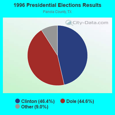
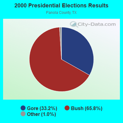
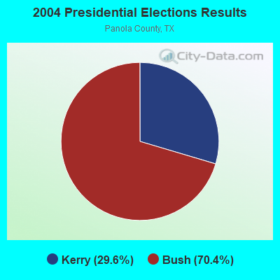
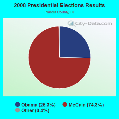
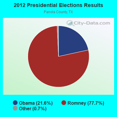
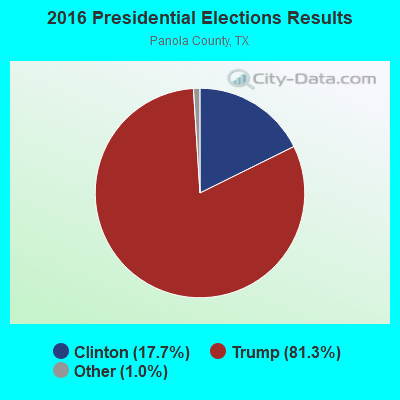
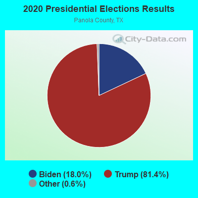
Graphs represent county-level data. Detailed 2008 Election Results
Religion statistics for Long Branch-Dotson, TX (based on Panola County data)
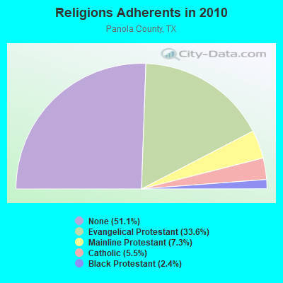
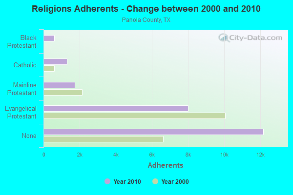
| Religion | Adherents | Congregations |
|---|---|---|
| Evangelical Protestant | 8,003 | 49 |
| Mainline Protestant | 1,736 | 13 |
| Catholic | 1,299 | 1 |
| Black Protestant | 582 | 7 |
| Other | 8 | 1 |
| None | 12,168 | - |
Food Environment Statistics:
| Panola County: | 1.74 / 10,000 pop. |
| State: | 1.47 / 10,000 pop. |
| This county: | 2.62 / 10,000 pop. |
| Texas: | 1.11 / 10,000 pop. |
| Panola County: | 6.54 / 10,000 pop. |
| State: | 3.95 / 10,000 pop. |
| This county: | 3.49 / 10,000 pop. |
| Texas: | 6.13 / 10,000 pop. |
| This county: | 10.5% |
| State: | 8.9% |
| Panola County: | 28.7% |
| State: | 26.6% |
| Panola County: | 12.7% |
| State: | 15.7% |
Strongest AM radio stations in Long Branch-Dotson:
- KEEL (710 AM; 50 kW; SHREVEPORT, LA; Owner: CITICASTERS LICENSES, L.P.)
- KWKH (1130 AM; 50 kW; SHREVEPORT, LA; Owner: CITICASTERS LICENSES, L.P.)
- KGAS (1590 AM; 2 kW; CARTHAGE, TX; Owner: JERRY T. HANSZEN)
- KWRD (1470 AM; 5 kW; HENDERSON, TX; Owner: JERRY RUSSELL D/B/A THE RUSSELL COMPANY)
- KOFY (1060 AM; daytime; 10 kW; GILMER, TX; Owner: JERRY RUSSELL D/B/A THE RUSSELL COMPANY)
- KTBB (600 AM; 5 kW; TYLER, TX; Owner: CITADEL BROADCASTING COMPANY)
- KTRH (740 AM; 50 kW; HOUSTON, TX; Owner: AMFM TEXAS LICENSES LIMITED PARTNERSHIP)
- KFXR (1190 AM; 50 kW; DALLAS, TX; Owner: CLEAR CHANNEL BROADCASTING LICENSES, INC.)
- KRLD (1080 AM; 50 kW; DALLAS, TX; Owner: TEXAS INFINITY BROADCASTING L.P.)
- KDET (930 AM; 1 kW; CENTER, TX; Owner: CENTER BROADCASTING COMPANY, INC.)
- WBAP (820 AM; 50 kW; FORT WORTH, TX; Owner: WBAP-KSCS OPERATING, LTD.)
- KGOL (1180 AM; 50 kW; HUMBLE, TX; Owner: ENTRAVISION HOLDINGS, LLC)
- KEES (1430 AM; 5 kW; GLADEWATER, TX; Owner: CITADEL BROADCASTING COMPANY)
Strongest FM radio stations in Long Branch-Dotson:
- KGAS-FM (104.3 FM; CARTHAGE, TX; Owner: HANSZEN BROADCASTING)
- KNUE (101.5 FM; TYLER, TX; Owner: CAPSTAR TX LIMITED PARTNERSHIP)
- KXAL-FM (100.3 FM; TATUM, TX; Owner: HUNT BROADCASTING, INC.)
- KPXI (100.7 FM; OVERTON, TX; Owner: INSPIRATION MEDIA OF TEXAS, LLC)
- KOOI (106.5 FM; JACKSONVILLE, TX; Owner: WALLER BROADCASTING, INC.)
- KRMD-FM (101.1 FM; SHREVEPORT, LA; Owner: CUMULUS LICENSING CORP.)
- KQBB (100.5 FM; CENTER, TX; Owner: CENTER BROADCASTING CO., INC.)
- KBJS (90.3 FM; JACKSONVILLE, TX; Owner: EAST TEXAS MEDIA ASSOCIATION, INC.)
- KTYL-FM (93.1 FM; TYLER, TX; Owner: CAPSTAR TX LIMITED PARTNERSHIP)
- KYKX (105.7 FM; LONGVIEW, TX; Owner: WALLER MEDIA, LLC)
- KTBQ (107.7 FM; NACOGDOCHES, TX; Owner: CAPSTAR TX LIMITED PARTNERSHIP)
- KAFX-FM (95.5 FM; DIBOLL, TX; Owner: CAPSTAR TX LIMITED PARTNERSHIP)
- KTUX (98.9 FM; CARTHAGE, TX; Owner: CITICASTERS LICENSES, L.P.)
TV broadcast stations around Long Branch-Dotson:
- KLSB-TV (Channel 19; NACOGDOCHES, TX; Owner: KLSB ACQUISITION CORP.)
- KFXK (Channel 51; LONGVIEW, TX; Owner: WARWICK COMMUNICATIONS, INC.)
- KTBS-TV (Channel 3; SHREVEPORT, LA; Owner: KTBS, INC.)
- KETK-TV (Channel 56; JACKSONVILLE, TX; Owner: KETK LICENSEE L.P.)
- KMSS-TV (Channel 33; SHREVEPORT, LA; Owner: COMCORP OF TEXAS LICENSE CORP.)
- KSLA-TV (Channel 12; SHREVEPORT, LA; Owner: KSLA, LLC)
- KSHV (Channel 45; SHREVEPORT, LA; Owner: WHITE KNIGHT BROADCASTING OF SHREVEPORT LIC. CORP.)
- KLPN-LP (Channel 58; LONGVIEW, TX; Owner: WARWICK COMMUNICATIONS, INC.)

- 48.0%Electricity
- 24.9%Utility gas
- 19.1%Bottled, tank, or LP gas
- 6.6%Wood
- 0.9%Solar energy
- 0.6%Fuel oil, kerosene, etc.

- 39.4%Electricity
- 34.3%Utility gas
- 15.2%Bottled, tank, or LP gas
- 11.1%Wood
Long Branch-Dotson compared to Texas state average:
- Median house value below state average.
- Unemployed percentage significantly below state average.
- Hispanic race population percentage significantly below state average.
- Median age significantly above state average.
- Foreign-born population percentage significantly below state average.
- Renting percentage significantly below state average.
- Length of stay since moving in significantly above state average.
- Number of rooms per house significantly below state average.
- House age significantly below state average.
- Number of college students below state average.
- Percentage of population with a bachelor's degree or higher below state average.