Mount Spokane, Washington
Submit your own pictures of this place and show them to the world
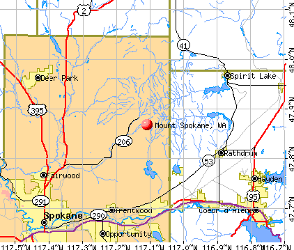
- OSM Map
- General Map
- Google Map
- MSN Map
| Males: 2,958 | |
| Females: 2,753 |
| Median resident age: | 38.4 years |
| Washington median age: | 35.3 years |
Zip code: 99021
| Mount Spokane: | $103,213 |
| WA: | $91,306 |
Estimated per capita income in 2022: $45,094 (it was $21,645 in 2000)
Mount Spokane CCD income, earnings, and wages data
Estimated median house or condo value in 2022: $592,984 (it was $158,700 in 2000)
| Mount Spokane: | $592,984 |
| WA: | $569,500 |
Mean prices in 2022: all housing units: $457,076; detached houses: $470,103; townhouses or other attached units: $805,398; in 2-unit structures: $303,176; in 3-to-4-unit structures: $346,699; in 5-or-more-unit structures: $339,273; mobile homes: $178,924; occupied boats, rvs, vans, etc.: $32,360
Detailed information about poverty and poor residents in Mount Spokane, WA


- 4,95194.4%White alone
- 1112.1%Two or more races
- 721.4%Hispanic
- 581.1%Asian alone
- 320.6%American Indian alone
- 160.3%Black alone
- 30.06%Native Hawaiian and Other
Pacific Islander alone - 10.02%Other race alone
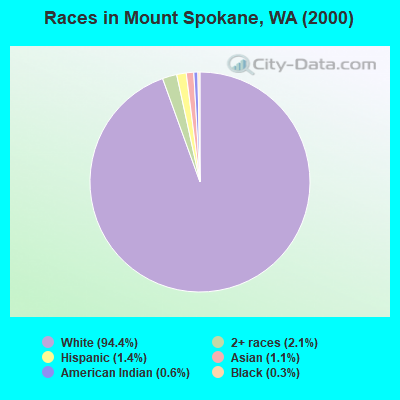
Races in Mount Spokane detailed stats: ancestries, foreign born residents, place of birth
 Recent articles from our blog. Our writers, many of them Ph.D. graduates or candidates, create easy-to-read articles on a wide variety of topics.

Current Local Time: PST time zone
Land area: 152.6 square miles.
Population density: 37 people per square mile (very low).
| Mount Spokane CCD: | 1.5% ($2,336) |
| Washington: | 1.2% ($1,915) |
Nearest city with pop. 50,000+: Spokane Valley, WA (14.7 miles  , pop. 89,755).
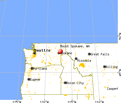
Nearest city with pop. 200,000+: East Seattle, WA (235.8 miles , pop. 480,100).
Nearest city with pop. 1,000,000+: Los Angeles, CA (955.5 miles , pop. 3,694,820).
Nearest cities:
), ), )Latitude: 47.87 N, Longitude: 117.11 W
Area code commonly used in this area: 208

| Here: | 5.0% |
| Washington: | 4.6% |
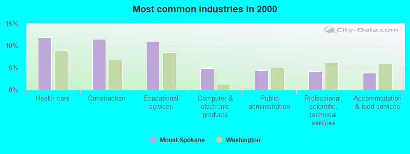
- Health care (11.9%)
- Construction (11.5%)
- Educational services (11.0%)
- Computer & electronic products (4.9%)
- Public administration (4.5%)
- Professional, scientific, technical services (4.2%)
- Accommodation & food services (3.9%)
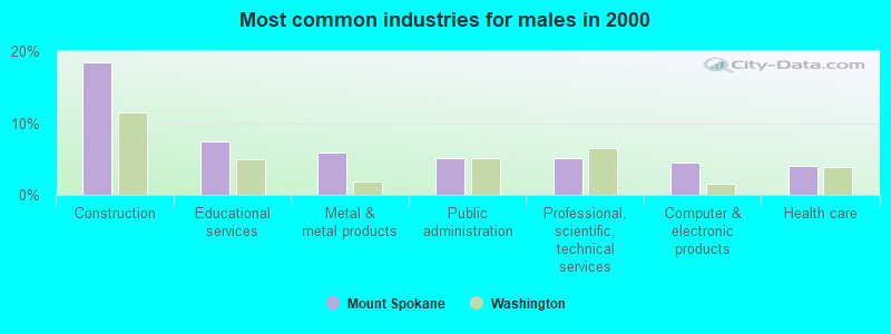
- Construction (18.4%)
- Educational services (7.5%)
- Metal & metal products (5.9%)
- Public administration (5.2%)
- Professional, scientific, technical services (5.2%)
- Computer & electronic products (4.5%)
- Health care (4.0%)
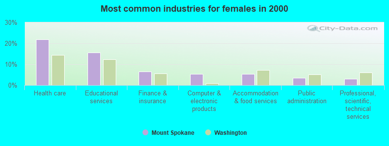
- Health care (21.8%)
- Educational services (15.5%)
- Finance & insurance (6.6%)
- Computer & electronic products (5.5%)
- Accommodation & food services (5.4%)
- Public administration (3.6%)
- Professional, scientific, technical services (3.0%)
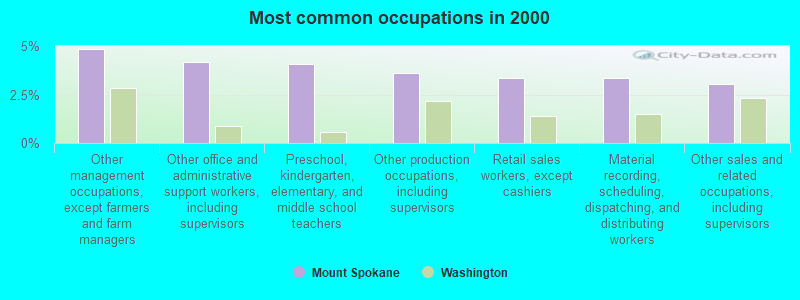
- Other management occupations, except farmers and farm managers (4.8%)
- Other office and administrative support workers, including supervisors (4.2%)
- Preschool, kindergarten, elementary, and middle school teachers (4.0%)
- Other production occupations, including supervisors (3.6%)
- Retail sales workers, except cashiers (3.4%)
- Material recording, scheduling, dispatching, and distributing workers (3.3%)
- Other sales and related occupations, including supervisors (3.1%)
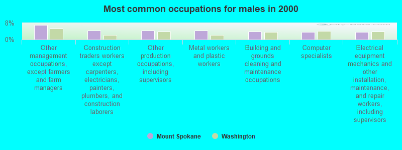
- Other management occupations, except farmers and farm managers (7.1%)
- Construction traders workers except carpenters, electricians, painters, plumbers, and construction laborers (4.4%)
- Other production occupations, including supervisors (4.3%)
- Metal workers and plastic workers (4.3%)
- Building and grounds cleaning and maintenance occupations (3.9%)
- Computer specialists (3.7%)
- Electrical equipment mechanics and other installation, maintenance, and repair workers, including supervisors (3.7%)
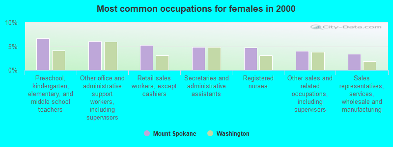
- Preschool, kindergarten, elementary, and middle school teachers (6.7%)
- Other office and administrative support workers, including supervisors (6.1%)
- Retail sales workers, except cashiers (5.3%)
- Secretaries and administrative assistants (4.9%)
- Registered nurses (4.7%)
- Other sales and related occupations, including supervisors (4.0%)
- Sales representatives, services, wholesale and manufacturing (3.4%)
Average climate in Mount Spokane, Washington
Based on data reported by over 4,000 weather stations


(lower is better)
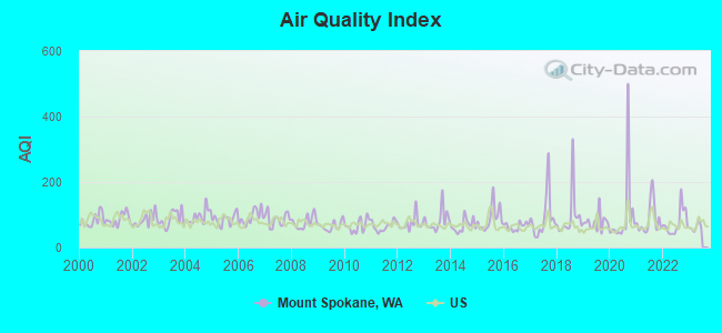
Air Quality Index (AQI) level in 2022 was 75.4. This is about average.
| City: | 75.4 |
| U.S.: | 72.6 |
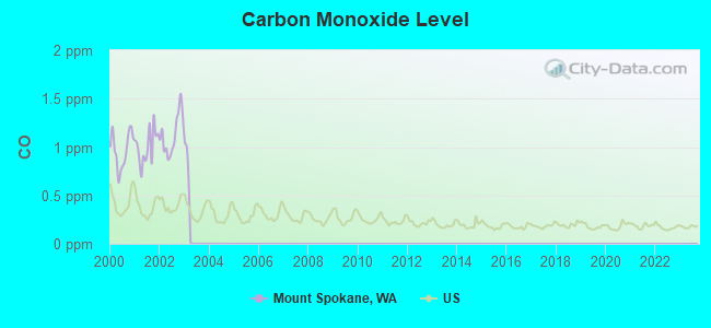
Carbon Monoxide (CO) [ppm] level in 2002 was 1.13. This is significantly worse than average. Closest monitor was 18.6 miles away from the city center.
| City: | 1.13 |
| U.S.: | 0.25 |
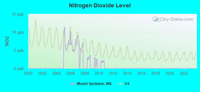
Nitrogen Dioxide (NO2) [ppb] level in 2007 was 6.56. This is worse than average. Closest monitor was 15.1 miles away from the city center.
| City: | 6.56 |
| U.S.: | 5.11 |
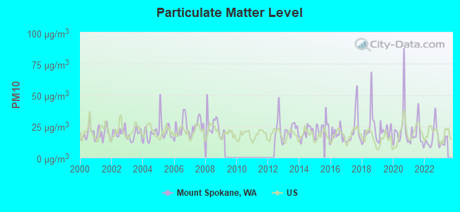
Particulate Matter (PM10) [µg/m3] level in 2022 was 16.3. This is about average. Closest monitor was 10.8 miles away from the city center.
| City: | 16.3 |
| U.S.: | 19.2 |
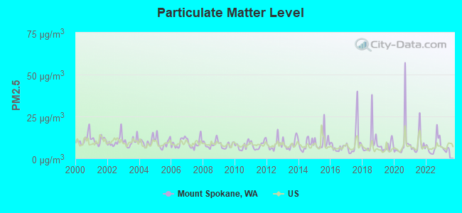
Particulate Matter (PM2.5) [µg/m3] level in 2022 was 7.70. This is about average. Closest monitor was 11.0 miles away from the city center.
| City: | 7.70 |
| U.S.: | 8.11 |
Earthquake activity:
Mount Spokane-area historical earthquake activity is significantly above Washington state average. It is 922% greater than the overall U.S. average.On 8/18/1959 at 06:37:13, a magnitude 7.7 (7.7 UK, Class: Major, Intensity: VIII - XII) earthquake occurred 383.9 miles away from Mount Spokane center, causing $26,000,000 total damage
On 10/28/1983 at 14:06:06, a magnitude 7.3 (6.2 MB, 7.3 MS, 7.0 MW) earthquake occurred 306.6 miles away from the city center, causing 2 deaths (2 shaking deaths) and 3 injuries, causing $15,000,000 total damage
On 4/13/1949 at 19:55:42, a magnitude 7.0 (7.0 UK) earthquake occurred 255.2 miles away from the city center, causing $80,000,000 total damage
On 2/28/2001 at 18:54:32, a magnitude 6.8 (6.5 MB, 6.6 MS, 6.8 MW, Class: Strong, Intensity: VII - IX) earthquake occurred 261.3 miles away from Mount Spokane center, causing $2,000,000,000 total damage and $305,000,000 insured losses
On 2/28/2001 at 18:54:32, a magnitude 6.8 (6.8 MD, Depth: 32.2 mi) earthquake occurred 267.1 miles away from the city center
On 4/29/1965 at 15:28:43, a magnitude 6.6 (6.6 UK) earthquake occurred 246.6 miles away from Mount Spokane center, causing $28,000,000 total damage
Magnitude types: body-wave magnitude (MB), duration magnitude (MD), surface-wave magnitude (MS), moment magnitude (MW)
Natural disasters:
The number of natural disasters in Spokane County (17) is near the US average (15).Major Disasters (Presidential) Declared: 11
Emergencies Declared: 4
Causes of natural disasters: Floods: 8, Storms: 5, Fires: 3, Landslides: 3, Mudslides: 3, Winter Storms: 3, Snows: 2, Drought: 1, Heavy Rain: 1, Hurricane: 1, Volcanic Eruption: 1, Wind: 1, Other: 1 (Note: some incidents may be assigned to more than one category).
Hospitals and medical centers near Mount Spokane:
- FMC POST FALLS DIALYSIS UNIT (Dialysis Facility, about 14 miles away; POST FALLS, ID)
- NORTHWEST SPECIALTY HOSPITAL Acute Care Hospitals (about 14 miles away; POST FALLS, ID)
- NORTHERN IDAHO ADVANCED CARE HOSPITAL (Hospital, about 15 miles away; POST FALLS, ID)
- MISSION GOOD SAMARITAN (Nursing Home, about 15 miles away; SPOKANE, WA)
- VALLEY HOSPITAL Acute Care Hospitals (about 15 miles away; SPOKANE, WA)
- FAMILY HOME CARE AND HOSPICE (Home Health Center, about 16 miles away; SPOKANE, WA)
- FMC VALLEY DIALYSIS UNIT (Dialysis Facility, about 16 miles away; SPOKANE, WA)
Colleges/universities with over 2000 students nearest to Mount Spokane:
- Whitworth University (about 17 miles; Spokane, WA; Full-time enrollment: 2,689)
- Spokane Community College (about 18 miles; Spokane, WA; FT enrollment: 6,482)
- Gonzaga University (about 20 miles; Spokane, WA; FT enrollment: 6,780)
- North Idaho College (about 20 miles; Coeur d'Alene, ID; FT enrollment: 4,684)
- Spokane Falls Community College (about 22 miles; Spokane, WA; FT enrollment: 6,052)
- Eastern Washington University (about 35 miles; Cheney, WA; FT enrollment: 11,643)
- Washington State University (about 79 miles; Pullman, WA; FT enrollment: 25,055)
Points of interest:
Notable locations in Mount Spokane: Camp Fosseen (A), Cooks Cabin (B), Foothills (C), Fothills (D), Homestead Campground (E), Mount Saint Charles Ranch (F), Mount Spokane Fire Station (G), Homestead Campground (H), Spokane County Fire District 13 Newman Lake Fire and Rescue Station 1 (I), Spokane County Fire District 13 Newman Lake Fire and Rescue Station 2 (J), Spokane County Fire District 4 Station 48 Mount Spokane (K). Display/hide their locations on the map
Cemetery: Saint Josephs Cemetery (1). Display/hide its location on the map
Swamps: Newman Lake (A). Display/hide its location on the map
Streams, rivers, and creeks: Burping Brook (A), McCabe Creek (B), North Fork Blanchard Creek (C), Ross Creek (D), Schackle Creek (E), South Fork Deadman Creek (F), Thompson Creek (G), Litter Creek (H), Shackle Creek (I). Display/hide their locations on the map
Park in Mount Spokane: Mount Spokane State Park (1). Display/hide its location on the map
| This place: | 2.7 people |
| Washington: | 2.5 people |
| This place: | 80.7% |
| Whole state: | 64.4% |
| This place: | 4.8% |
| Whole state: | 7.7% |
Likely homosexual households (counted as self-reported same-sex unmarried-partner households)
- Lesbian couples: 0.3% of all households
- Gay men: 0.1% of all households
| This place: | 6.8% |
| Whole state: | 10.6% |
| This place: | 3.4% |
| Whole state: | 4.6% |
21 people in other group homes in 2000
3 people in other noninstitutional group quarters in 2000
For population 15 years and over in Mount Spokane:
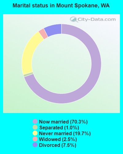
- Never married: 19.7%
- Now married: 70.3%
- Separated: 1.0%
- Widowed: 2.5%
- Divorced: 7.5%
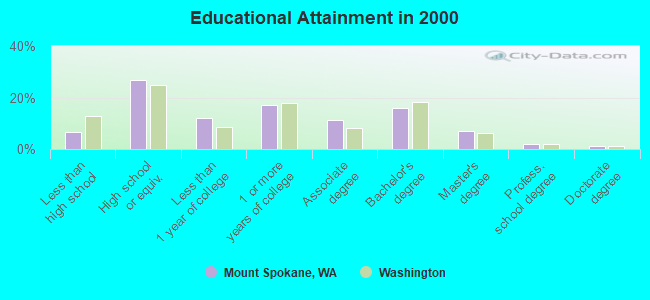
For population 25 years and over in Mount Spokane:
- High school or higher: 93.5%
- Bachelor's degree or higher: 26.1%
- Graduate or professional degree: 10.0%
- Unemployed: 7.7%
- Mean travel time to work (commute): 28.3 minutes
| Here: | 9.3 |
| Washington average: | 11.3 |
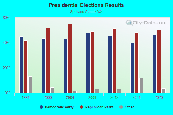
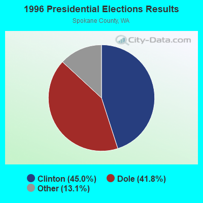
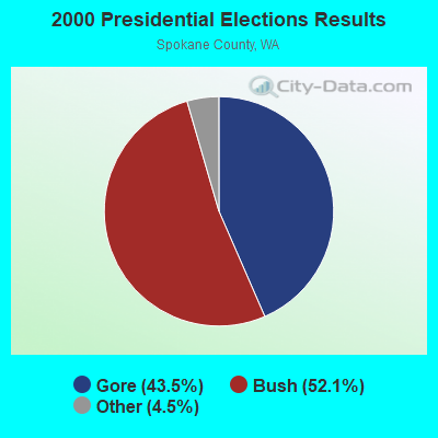
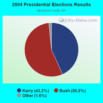
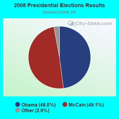
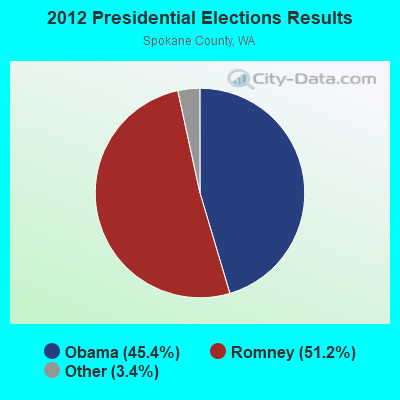
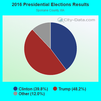
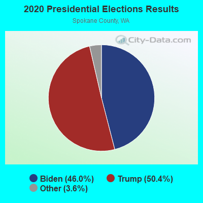
Graphs represent county-level data. Detailed 2008 Election Results
Religion statistics for Mount Spokane, WA (based on Spokane County data)
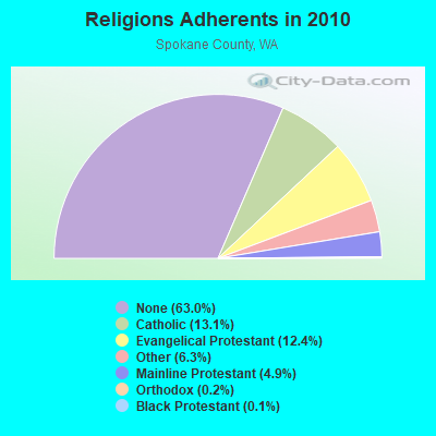
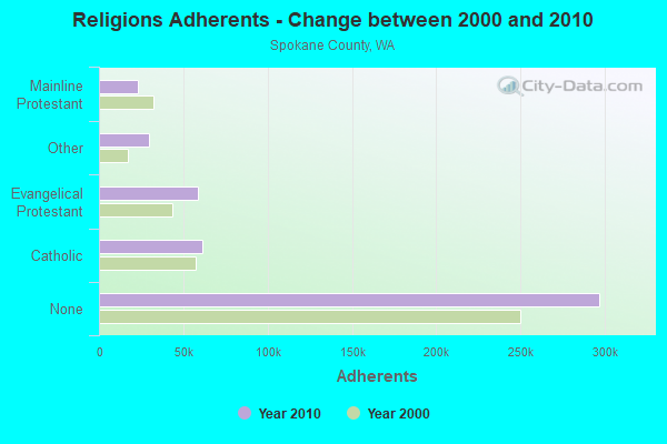
| Religion | Adherents | Congregations |
|---|---|---|
| Catholic | 61,575 | 27 |
| Evangelical Protestant | 58,417 | 217 |
| Other | 29,621 | 84 |
| Mainline Protestant | 23,240 | 81 |
| Orthodox | 754 | 3 |
| Black Protestant | 682 | 4 |
| None | 296,932 | - |
Food Environment Statistics:
| Spokane County: | 1.80 / 10,000 pop. |
| Washington: | 2.06 / 10,000 pop. |
| Spokane County: | 0.18 / 10,000 pop. |
| State: | 0.19 / 10,000 pop. |
| Spokane County: | 0.61 / 10,000 pop. |
| Washington: | 1.18 / 10,000 pop. |
| Spokane County: | 2.59 / 10,000 pop. |
| Washington: | 2.67 / 10,000 pop. |
| Spokane County: | 6.16 / 10,000 pop. |
| State: | 8.26 / 10,000 pop. |
| This county: | 8.2% |
| Washington: | 7.7% |
| Here: | 27.2% |
| State: | 25.7% |
| Spokane County: | 9.7% |
| State: | 13.9% |
6.26% of this county's 2021 resident taxpayers lived in other counties in 2020 ($66,178 average adjusted gross income)
| Here: | 6.26% |
| Washington average: | 7.53% |
0.07% of residents moved from foreign countries ($698 average AGI)
Spokane County: 0.07% Washington average: 0.05%
Top counties from which taxpayers relocated into this county between 2020 and 2021:
| from Kootenai County, ID | |
| from King County, WA | |
| from Snohomish County, WA |
5.60% of this county's 2020 resident taxpayers moved to other counties in 2021 ($58,474 average adjusted gross income)
| Here: | 5.60% |
| Washington average: | 7.40% |
0.04% of residents moved to foreign countries ($518 average AGI)
Spokane County: 0.04% Washington average: 0.04%
Top counties to which taxpayers relocated from this county between 2020 and 2021:
| to Kootenai County, ID | |
| to King County, WA | |
| to Stevens County, WA |
Strongest AM radio stations in Mount Spokane:
- KXLY (920 AM; 20 kW; SPOKANE, WA; Owner: SPOKANE RADIO, INC.)
- KGA (1510 AM; 50 kW; SPOKANE, WA; Owner: CITADEL BROADCASTING COMPANY)
- KMJY (700 AM; 10 kW; NEWPORT, WA; Owner: JAMES E. AND HELEN G. STARGEL)
- KQNT (590 AM; 5 kW; SPOKANE, WA; Owner: CAPSTAR TX LIMITED PARTNERSHIP)
- KVNI (1080 AM; 10 kW; COEUR D' ALENE, ID; Owner: QUEENB RADIO, INC.)
- KJRB (790 AM; 5 kW; SPOKANE, WA; Owner: CITADEL BROADCASTING COMPANY)
- KTRW (970 AM; 5 kW; SPOKANE, WA; Owner: KTRW, LLC)
- KDRK (1050 AM; 5 kW; DISHMAN, WA; Owner: CITADEL BROADCASTING COMPANY)
- KAQQ (1280 AM; 5 kW; SPOKANE, WA)
- KMBI (1330 AM; daytime; 5 kW; SPOKANE, WA; Owner: THE MOODY BIBLE INSTITUTE OF CHICAGO)
- KTBI (810 AM; daytime; 50 kW; EPHRATA, WA; Owner: TACOMA BROADCASTERS, INCORPORATED)
- KQQQ (1150 AM; 25 kW; PULLMAN, WA; Owner: RADIO PALOUSE, INC.)
- KERR (750 AM; 50 kW; POLSON, MT; Owner: ANDERSON RADIO BROADCASTING, INC.)
Strongest FM radio stations in Mount Spokane:
- KXLY-FM (99.9 FM; SPOKANE, WA; Owner: SPOKANE RADIO, INC.)
- KCDA (103.1 FM; POST FALLS, ID; Owner: CAPSTAR TX LIMITED PARTNERSHIP)
- KICR (102.3 FM; COEUR D'ALENE, ID; Owner: GREAT NORTHERN BROADCASTING, INC.)
- KDRK-FM (93.7 FM; SPOKANE, WA; Owner: CITADEL BROADCASTING COMPANY)
- KIXZ-FM (96.1 FM; OPPORTUNITY, WA; Owner: CAPSTAR TX LIMITED PARTNERSHIP)
- KMBI-FM (107.9 FM; SPOKANE, WA; Owner: THE MOODY BIBLE INSTITUTE OF CHICAGO)
- KPBX-FM (91.1 FM; SPOKANE, WA; Owner: SPOKANE PUBLIC RADIO, INC.)
- KHTQ (94.5 FM; HAYDEN, ID; Owner: QUEENB RADIO, INC.)
- KZZU-FM (92.9 FM; SPOKANE, WA; Owner: QUEENB)
- KEYF-FM (101.1 FM; CHENEY, WA; Owner: CITADEL BROADCASTING COMPANY)
- KISC (98.1 FM; SPOKANE, WA; Owner: CAPSTAR TX LIMITED PARTNERSHIP)
- KZBD (105.7 FM; SPOKANE, WA; Owner: CITADEL BROADCASTING COMPANY)
- KEZE (96.9 FM; SPOKANE, WA; Owner: QUEENB RADIO, INC.)
- KAGU (88.7 FM; SPOKANE, WA; Owner: GONZAGA UNIVERSITY TELECOMMUNICATIONS ASSOCIATION)
- KKZX (98.9 FM; SPOKANE, WA; Owner: CAPSTAR TX LIMITED PARTNERSHIP)
- KSFC (91.9 FM; SPOKANE, WA; Owner: SPOKANE PUBLIC RADIO)
- KEEH (104.9 FM; SPOKANE, WA; Owner: UPPER COLUMBIA MEDIA ASSOCIATION)
- KYWL (103.9 FM; SPOKANE, WA; Owner: CITADEL BROADCASTING COMPANY)
- KMJY-FM (104.5 FM; NEWPORT, WA; Owner: ALC COMMUNICATIONS)
- KEWU-FM (89.5 FM; CHENEY, WA; Owner: EASTERN WASHINGTON UNIVERSITY)
TV broadcast stations around Mount Spokane:
- KXLY-TV (Channel 4; SPOKANE, WA; Owner: SPOKANE TELEVISION, INC.)
- K59BW (Channel 59; BONNERS FERRY, ID; Owner: STATE BOARD OF EDUCATION (IEPBS))
- KREM-TV (Channel 2; SPOKANE, WA; Owner: KING BROADCASTING COMPANY)
- KHQ-TV (Channel 6; SPOKANE, WA; Owner: KHQ, INCORPORATED)
- KAYU-TV (Channel 28; SPOKANE, WA; Owner: MOUNTAIN LICENSES, L.P.)
- KSPS-TV (Channel 7; SPOKANE, WA; Owner: SPOKANE SCHOOL DISTRICT #81)
- KSKN (Channel 22; SPOKANE, WA; Owner: KSKN TELEVISION, INC.)
- K09FZ (Channel 9; SPOKANE, ETC., WA; Owner: SPOKANE TELEVISION, INC.)
- KGPX (Channel 34; SPOKANE, WA; Owner: PAXSON SPOKANE LICENSE, INC.)
- K14IF (Channel 14; SPOKANE, WA; Owner: VENTANA TELEVISION, INC.)
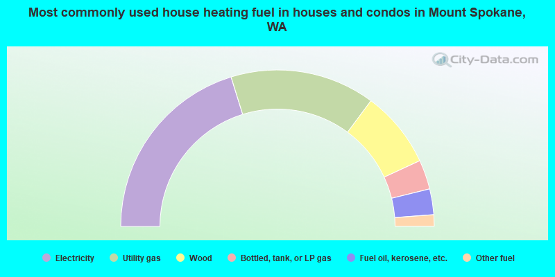
- 40.5%Electricity
- 29.9%Utility gas
- 15.9%Wood
- 6.1%Bottled, tank, or LP gas
- 5.3%Fuel oil, kerosene, etc.
- 2.4%Other fuel
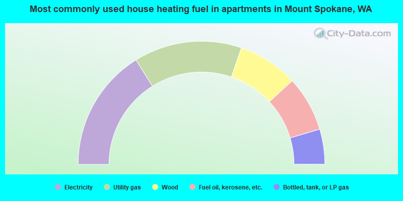
- 32.2%Electricity
- 28.3%Utility gas
- 15.8%Wood
- 14.5%Fuel oil, kerosene, etc.
- 9.2%Bottled, tank, or LP gas
Mount Spokane compared to Washington state average:
- Unemployed percentage below state average.
- Black race population percentage significantly below state average.
- Hispanic race population percentage significantly below state average.
- Median age above state average.
- Foreign-born population percentage significantly below state average.
- Renting percentage significantly below state average.
- Length of stay since moving in significantly above state average.
- Number of rooms per house significantly below state average.
- House age significantly below state average.
Mount Spokane on our top lists:
- #11 on the list of "Top 101 cities with largest percentage of males in industries: metals and minerals, except petroleum, merchant wholesalers (population 5,000+)"
- #14 on the list of "Top 101 cities with largest percentage of females in occupations: communications equipment operators (population 5,000+)"
- #21 on the list of "Top 101 cities with largest percentage of females in occupations: supervisors of construction and extraction workers (population 5,000+)"
- #33 on the list of "Top 101 cities with largest percentage of males in industries: health and personal care, except drug, stores (population 5,000+)"
- #37 on the list of "Top 101 cities with largest percentage of females in industries: furniture and related product manufacturing (population 5,000+)"
- #43 on the list of "Top 101 cities with largest percentage of females in industries: computer and electronic products (population 5,000+)"
- #50 on the list of "Top 101 cities with largest percentage of females in industries: truck transportation (population 5,000+)"
- #61 on the list of "Top 101 cities with largest percentage of females in industries: miscellaneous nondurable goods merchant wholesalers (population 5,000+)"
- #68 on the list of "Top 101 cities with largest percentage of females in occupations: woodworkers (population 5,000+)"
- #72 on the list of "Top 101 cities with largest percentage of females in occupations: agricultural workers including supervisors (population 5,000+)"
- #73 on the list of "Top 101 cities with largest percentage of females in industries: hardware, plumbing and heating equipment, and supplies merchant wholesalers (population 5,000+)"
- #79 on the list of "Top 101 cities with largest percentage of females in occupations: financial managers (population 5,000+)"
- #85 on the list of "Top 101 cities with largest percentage of males in industries: furniture and related product manufacturing (population 5,000+)"
- #93 on the list of "Top 101 cities with largest percentage of males in occupations: drafters, engineering, and mapping technicians (population 5,000+)"
- #95 on the list of "Top 101 cities with largest percentage of females in industries: health care (population 5,000+)"
- #96 on the list of "Top 101 cities with largest percentage of females in industries: building material and garden equipment and supplies dealers (population 5,000+)"
- #19 on the list of "Top 101 counties with the lowest surface withdrawal of fresh water for public supply (pop. 50,000+)"
- #21 on the list of "Top 101 counties with the highest ground withdrawal of fresh water for public supply"
- #45 on the list of "Top 101 counties with the highest average weight of females"
- #64 on the list of "Top 101 counties with the highest Particulate Matter (PM10) Annual air pollution readings in 2012 (µg/m3)"
- #67 on the list of "Top 101 counties with the most Other congregations (pop. 50,000+)"