Northeast Wilson, Tennessee
Submit your own pictures of this place and show them to the world
- OSM Map
- General Map
- Google Map
- MSN Map

| Males: 6,504 | |
| Females: 6,436 |
| Median resident age: | 36.2 years |
| Tennessee median age: | 35.9 years |
Zip code: 37087
| Northeast Wilson: | $84,189 |
| TN: | $65,254 |
Estimated per capita income in 2022: $36,717 (it was $20,782 in 2000)
Northeast Wilson CCD income, earnings, and wages data
Estimated median house or condo value in 2022: $407,571 (it was $124,100 in 2000)
| Northeast Wilson: | $407,571 |
| TN: | $284,800 |
Mean prices in 2022: all housing units: $407,188; detached houses: $422,191; townhouses or other attached units: $373,317; in 2-unit structures: $473,922; in 3-to-4-unit structures: $306,966; in 5-or-more-unit structures: $213,157; mobile homes: $135,534
Northeast Wilson, TN residents, houses, and apartments details
Detailed information about poverty and poor residents in Northeast Wilson, TN


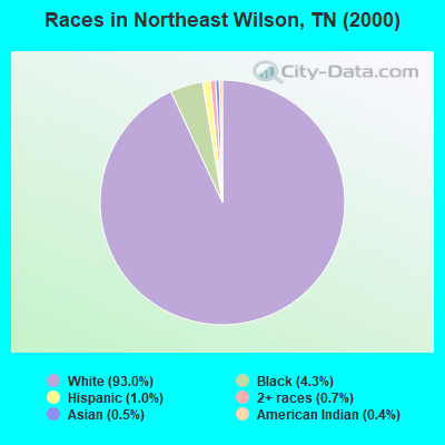
- 10,08893.0%White alone
- 4674.3%Black alone
- 1041.0%Hispanic
- 790.7%Two or more races
- 500.5%Asian alone
- 450.4%American Indian alone
- 70.06%Other race alone
- 20.02%Native Hawaiian and Other
Pacific Islander alone
Races in Northeast Wilson detailed stats: ancestries, foreign born residents, place of birth
 Recent articles from our blog. Our writers, many of them Ph.D. graduates or candidates, create easy-to-read articles on a wide variety of topics.

Current Local Time: CST time zone
Land area: 116.6 square miles.
Population density: 111 people per square mile (very low).

| Northeast Wilson CCD: | 0.7% ($858) |
| Tennessee: | 0.8% ($715) |
Nearest city with pop. 50,000+: Murfreesboro, TN  (28.9 miles , pop. 68,816).
Nearest city with pop. 200,000+: Nashville-Davidson, TN (29.7 miles , pop. 545,524).
Nearest city with pop. 1,000,000+: Chicago, IL (393.8 miles , pop. 2,896,016).
Nearest cities:
), ), ), ), Latitude: 36.26 N, Longitude: 86.25 W
Area code commonly used in this area: 615

| Here: | 2.5% |
| Tennessee: | 3.0% |
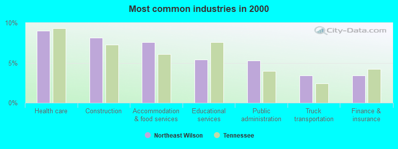
- Health care (9.0%)
- Construction (8.1%)
- Accommodation & food services (7.6%)
- Educational services (5.4%)
- Public administration (5.3%)
- Truck transportation (3.4%)
- Finance & insurance (3.4%)
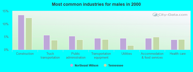
- Construction (13.5%)
- Truck transportation (5.7%)
- Public administration (5.3%)
- Transportation equipment (4.5%)
- Utilities (4.5%)
- Accommodation & food services (4.4%)
- Health care (3.9%)
- Health care (15.1%)
- Accommodation & food services (11.4%)
- Educational services (9.1%)
- Public administration (5.2%)
- Finance & insurance (4.5%)
- Professional, scientific, technical services (4.1%)
- Food & beverage stores (3.6%)
- Other production occupations, including supervisors (6.4%)
- Driver/sales workers and truck drivers (4.1%)
- Other sales and related occupations, including supervisors (3.6%)
- Material recording, scheduling, dispatching, and distributing workers (3.6%)
- Other management occupations, except farmers and farm managers (3.6%)
- Laborers and material movers, hand (3.4%)
- Metal workers and plastic workers (3.4%)
- Other production occupations, including supervisors (7.1%)
- Driver/sales workers and truck drivers (6.8%)
- Metal workers and plastic workers (5.2%)
- Material recording, scheduling, dispatching, and distributing workers (4.5%)
- Electrical equipment mechanics and other installation, maintenance, and repair workers, including supervisors (4.3%)
- Other management occupations, except farmers and farm managers (4.3%)
- Laborers and material movers, hand (4.2%)
- Other office and administrative support workers, including supervisors (6.5%)
- Secretaries and administrative assistants (5.9%)
- Preschool, kindergarten, elementary, and middle school teachers (5.7%)
- Other production occupations, including supervisors (5.5%)
- Cashiers (4.5%)
- Information and record clerks, except customer service representatives (3.5%)
- Registered nurses (3.5%)
Average climate in Northeast Wilson, Tennessee
Based on data reported by over 4,000 weather stations


(lower is better)
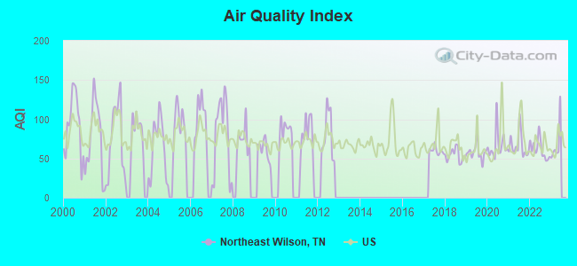
Air Quality Index (AQI) level in 2022 was 61.7. This is about average.
| City: | 61.7 |
| U.S.: | 72.6 |
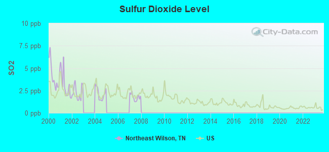
Sulfur Dioxide (SO2) [ppb] level in 2007 was 1.77. This is about average. Closest monitor was 8.2 miles away from the city center.
| City: | 1.77 |
| U.S.: | 1.51 |
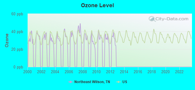
Ozone [ppb] level in 2012 was 31.9. This is about average. Closest monitor was 22.4 miles away from the city center.
| City: | 31.9 |
| U.S.: | 33.3 |
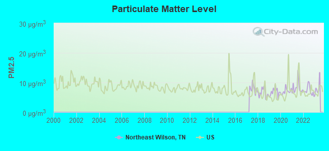
Particulate Matter (PM2.5) [µg/m3] level in 2022 was 7.25. This is about average. Closest monitor was 22.9 miles away from the city center.
| City: | 7.25 |
| U.S.: | 8.11 |
Tornado activity:
Northeast Wilson-area historical tornado activity is slightly above Tennessee state average. It is 66% greater than the overall U.S. average.
On 4/27/1970, a category F4 (max. wind speeds 207-260 mph) tornado 21.4 miles away from the Northeast Wilson place center killed 3 people and injured 85 people and caused between $500,000 and $5,000,000 in damages.
On 1/24/1997, a category F4 tornado 30.5 miles away from the place center injured 18 people and caused $5 million in damages.
Earthquake activity:
Northeast Wilson-area historical earthquake activity is significantly above Tennessee state average. It is 169% greater than the overall U.S. average.On 4/18/2008 at 09:36:59, a magnitude 5.4 (5.1 MB, 4.8 MS, 5.4 MW, 5.2 MW, Class: Moderate, Intensity: VI - VII) earthquake occurred 176.6 miles away from the city center
On 4/18/2008 at 09:36:59, a magnitude 5.2 (5.2 MW, Depth: 8.9 mi) earthquake occurred 176.6 miles away from the city center
On 7/27/1980 at 18:52:21, a magnitude 5.2 (5.1 MB, 4.7 MS, 5.0 UK, 5.2 UK) earthquake occurred 185.0 miles away from the city center
On 6/18/2002 at 17:37:15, a magnitude 5.0 (4.3 MB, 4.6 MW, 5.0 LG) earthquake occurred 146.5 miles away from Northeast Wilson center
On 4/29/2003 at 08:59:39, a magnitude 4.9 (4.4 MB, 4.6 MW, 4.9 LG, Class: Light, Intensity: IV - V) earthquake occurred 126.8 miles away from the city center
On 6/10/1987 at 23:48:54, a magnitude 5.1 (4.9 MB, 4.4 MS, 4.6 MS, 5.1 LG) earthquake occurred 198.8 miles away from Northeast Wilson center
Magnitude types: regional Lg-wave magnitude (LG), body-wave magnitude (MB), surface-wave magnitude (MS), moment magnitude (MW)
Natural disasters:
The number of natural disasters in Wilson County (10) is smaller than the US average (15).Major Disasters (Presidential) Declared: 6
Emergencies Declared: 2
Causes of natural disasters: Tornadoes: 6, Floods: 5, Storms: 5, Winds: 2, Winter Storms: 2, Flash Flood: 1, Hurricane: 1, Ice Storm: 1, Snowfall: 1, Other: 1 (Note: some incidents may be assigned to more than one category).
Hospitals and medical centers near Northeast Wilson:
- CAREALL HOMECARE SERVICES (Home Health Center, about 5 miles away; LEBANON, TN)
- MCFARLAND HOSPITAL (Hospital, about 5 miles away; LEBANON, TN)
- QUALITY CARE HEALTH CENTER (Nursing Home, about 5 miles away; LEBANON, TN)
- LEBANON HEALTH AND REHABILITATION CENTER (Nursing Home, about 5 miles away; LEBANON, TN)
- DCI LEBANON (Dialysis Facility, about 6 miles away; LEBANON, TN)
- UNIVERSITY MEDICAL CENTER Acute Care Hospitals (about 6 miles away; LEBANON, TN)
- DONELSON HOME HEALTH (Home Health Center, about 6 miles away; LEBANON, TN)
Colleges/universities with over 2000 students nearest to Northeast Wilson:
- Volunteer State Community College (about 16 miles; Gallatin, TN; Full-time enrollment: 5,311)
- Middle Tennessee State University (about 29 miles; Murfreesboro, TN; FT enrollment: 21,628)
- Trevecca Nazarene University (about 30 miles; Nashville, TN; FT enrollment: 2,223)
- Belmont University (about 32 miles; Nashville, TN; FT enrollment: 5,795)
- Vanderbilt University (about 33 miles; Nashville, TN; FT enrollment: 10,518)
- Lipscomb University (about 33 miles; Nashville, TN; FT enrollment: 3,827)
- Tennessee State University (about 34 miles; Nashville, TN; FT enrollment: 7,341)
Points of interest:
Notable locations in Northeast Wilson: Wilson Boat Dock (A), Misty Cove Marina (B), Wilson County Landfill (C), Wilson Emergency Management Agency Station 8 Tuckers Crossroads (D). Display/hide their locations on the map
Churches in Northeast Wilson include: Berea Church (A), Good Hope Church (B), Goshen Church (C), Athens Missionary Church (D), Grissim Church (E), Sandy Chapel (F), Saulsbury Church (G), Philadelphia Church (H), Hopewell Church (I). Display/hide their locations on the map
Cemeteries: Tomlinson Cemetery (1), Jackson Cemetery (2), Watson Cemetery (3), White Cemetery (4), Wier Cemetery (5), Bethlehem Cemetery (6), Chapman Cemetery (7). Display/hide their locations on the map
Reservoir: Greenbriar Lake (A). Display/hide its location on the map
Streams, rivers, and creeks: Link Branch (A), Bartons Creek (B), Johnson Branch (C), Jackson Branch (D), Wilborn Branch (E), Graves Branch (F), Everetts Branch (G), Clendenon Branch (H), Clifford Branch (I). Display/hide their locations on the map
Parks in Northeast Wilson include: Dickson Chapel Recreation Area (1), Coles Ferry Access Area (2), Sandy Chapel Access Area (3), Hunters Point Access Area (4). Display/hide their locations on the map
| This place: | 2.7 people |
| Tennessee: | 2.5 people |
| This place: | 69.4% |
| Whole state: | 69.8% |
| This place: | 3.9% |
| Whole state: | 4.2% |
Likely homosexual households (counted as self-reported same-sex unmarried-partner households)
- Lesbian couples: 0.3% of all households
- Gay men: 0.2% of all households
| This place: | 5.9% |
| Whole state: | 13.5% |
| This place: | 2.5% |
| Whole state: | 5.8% |
For population 15 years and over in Northeast Wilson:
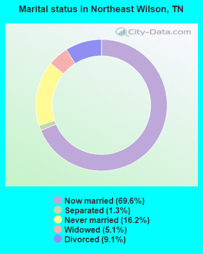
- Never married: 16.2%
- Now married: 69.6%
- Separated: 1.3%
- Widowed: 5.1%
- Divorced: 9.1%
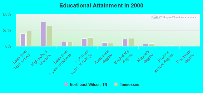
For population 25 years and over in Northeast Wilson:
- High school or higher: 80.0%
- Bachelor's degree or higher: 16.3%
- Graduate or professional degree: 5.1%
- Unemployed: 3.5%
- Mean travel time to work (commute): 27.9 minutes
| Here: | 11.7 |
| Tennessee average: | 13.3 |
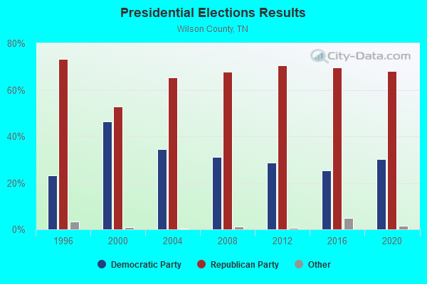
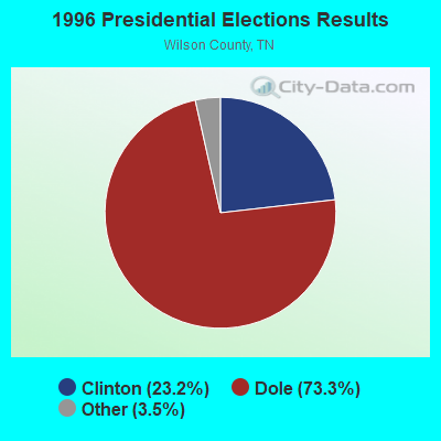
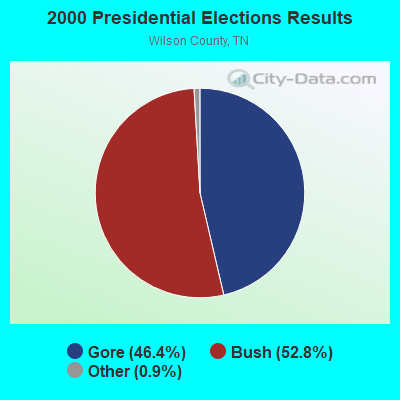
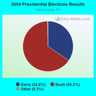
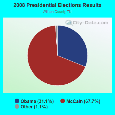


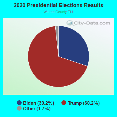
Graphs represent county-level data. Detailed 2008 Election Results
Religion statistics for Northeast Wilson, TN (based on Wilson County data)
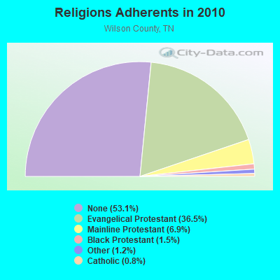
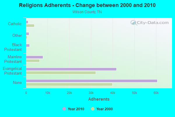
| Religion | Adherents | Congregations |
|---|---|---|
| Evangelical Protestant | 41,655 | 121 |
| Mainline Protestant | 7,843 | 26 |
| Black Protestant | 1,674 | 10 |
| Other | 1,353 | 7 |
| Catholic | 900 | 1 |
| None | 60,568 | - |
Food Environment Statistics:
| This county: | 1.51 / 10,000 pop. |
| Tennessee: | 1.99 / 10,000 pop. |
| Wilson County: | 0.09 / 10,000 pop. |
| Tennessee: | 0.17 / 10,000 pop. |
| Wilson County: | 0.38 / 10,000 pop. |
| State: | 0.65 / 10,000 pop. |
| Here: | 4.61 / 10,000 pop. |
| Tennessee: | 5.16 / 10,000 pop. |
| This county: | 6.12 / 10,000 pop. |
| State: | 6.56 / 10,000 pop. |
| Wilson County: | 9.9% |
| Tennessee: | 11.4% |
| Wilson County: | 29.3% |
| State: | 30.2% |
| Wilson County: | 12.5% |
| State: | 13.5% |
Strongest AM radio stations in Northeast Wilson:
- WAMB (1160 AM; 50 kW; DONELSON, TN; Owner: GREAT SOUTHERN BROADCASTING COMPANY, INC.)
- WSM (650 AM; 50 kW; NASHVILLE, TN; Owner: GAYLORD ENTERTAINMENT COMPANY)
- WLAC (1510 AM; 50 kW; NASHVILLE, TN; Owner: CAPSTAR TX LIMITED PARTNERSHIP)
- WKDA (1200 AM; 50 kW; NASHVILLE, TN; Owner: RADIO NASHVILLE, INC.)
- WNQM (1300 AM; 50 kW; NASHVILLE, TN; Owner: WNQM. INC.)
- WHIN (1010 AM; 5 kW; GALLATIN, TN; Owner: WHIN, INC.)
- WPLN (1430 AM; 15 kW; MADISON, TN)
- WTNK (1090 AM; 1 kW; HARTSVILLE, TN; Owner: G & L AIRCASTERS, INC.)
- WYFN (980 AM; 5 kW; NASHVILLE, TN; Owner: BIBLE BRADCASTING NETWORK, INC.)
- WYXE (1130 AM; daytime; 2 kW; GALLATIN, TN; Owner: JON GARY ENTERPRISES, INC.)
- WWAM (820 AM; daytime; 50 kW; JASPER, TN; Owner: SHELTON BROADCASTING SYSTEM)
- WCOR (900 AM; 5 kW; LEBANON, TN)
- WMGC (810 AM; 5 kW; MURFREESBORO, TN; Owner: RADIO 810 NASHVILLE, LIMITED)
Strongest FM radio stations in Northeast Wilson:
- WANT (98.9 FM; LEBANON, TN; Owner: BAY-POINTE BROADCASTING, INC.)
- WFMQ (91.5 FM; LEBANON, TN; Owner: CUMBERLAND UNIVERSITY)
- WMOT (89.5 FM; MURFREESBORO, TN; Owner: MIDDLE TENNESSEE STATE UNIVERSITY)
- W270AB (101.9 FM; LEBANON, TN; Owner: TREVECCA NAZARENE UNIVERSITY, INC.)
- WGFX (104.5 FM; GALLATIN, TN; Owner: CITADEL BROADCASTING COMPANY)
- WMAK (96.3 FM; MURFREESBORO, TN; Owner: SOUTH CENTRAL COMMUNICATIONS CORP.)
- WRVW (107.5 FM; LEBANON, TN; Owner: CAPSTAR TX LIMITED PARTNERSHIP)
- WSM-FM (95.5 FM; NASHVILLE, TN; Owner: CUMULUS LICENSING CORP.)
- WRLT (100.1 FM; FRANKLIN, TN; Owner: TUNED-IN BROADCASTING, INC)
- WVCP (88.5 FM; GALLATIN, TN; Owner: VOLUNTEER STATE COMMUNITY COLLEGE)
- WKDF (103.3 FM; NASHVILLE, TN; Owner: CITADEL BROADCASTING COMPANY)
- WNRQ (105.9 FM; NASHVILLE, TN; Owner: CAPSTAR TX LIMITED PARTNERSHIP)
- WSIX-FM (97.9 FM; NASHVILLE, TN; Owner: CAPSTAR TX LIMITED PARTNERSHIP)
- WPLN-FM (90.3 FM; NASHVILLE, TN; Owner: NASHVILLE PUBLIC RADIO)
- WNPL (106.7 FM; BELLE MEADE, TN; Owner: CUMULUS LICENSING CORP.)
- WAYM (88.7 FM; COLUMBIA, TN; Owner: WAY-FM MEDIA GROUP, INC.)
- WUCZ (104.1 FM; CARTHAGE, TN; Owner: WOOD BROADCASTING, INC.)
- WWTN (99.7 FM; MANCHESTER, TN; Owner: CUMULUS LICENSING CORP.)
- WBUZ (102.9 FM; LA VERGNE, TN; Owner: WYCQ, INC)
- WJXA (92.9 FM; NASHVILLE, TN; Owner: SOUTH CENTRAL COMMUNICATIONS CORP.)
TV broadcast stations around Northeast Wilson:
- WPGD (Channel 50; HENDERSONVILLE, TN; Owner: TRINITY BROADCASTING NETWORK)
- WHTN (Channel 39; MURFREESBORO, TN; Owner: CHRISTIAN TELEVISION NETWORK, INC.)
- W11BD (Channel 11; LEBANON, TN; Owner: JOE F. BRYANT, MD)
- WTVF (Channel 5; NASHVILLE, TN; Owner: NEWSCHANNEL 5 NETWORK, LP)
- WNPX (Channel 28; COOKEVILLE, TN; Owner: PAXSON COMMUNICATIONS LICENSE COMPANY, LLC)
- WUXP-TV (Channel 30; NASHVILLE, TN; Owner: WUXP LICENSEE, LLC)
- WJFB (Channel 66; LEBANON, TN; Owner: BRYANT BROADCASTING, INC.)
- WSMV-TV (Channel 4; NASHVILLE, TN; Owner: MEREDITH CORPORATION)
- WNAB (Channel 58; NASHVILLE, TN; Owner: NASHVILLE LICENSE HOLDINGS, L.L.C.)
- WZTV (Channel 17; NASHVILLE, TN; Owner: WZTV LICENSEE, LLC)
- WKRN-TV (Channel 2; NASHVILLE, TN; Owner: WKRN, G.P.)
- WNPT (Channel 8; NASHVILLE, TN; Owner: NASHVILLE PUBLIC TELEVISION, INC.)
- WNPX-LP (Channel 20; NASHVILLE, TN; Owner: PAXSON COMMUNICATIONS LPTV, INC.)
- W36AK (Channel 36; NASHVILLE, TN; Owner: TRINITY BROADCASTING NETWORK)
- WIIW-LP (Channel 14; NASHVILLE, TN; Owner: EQUITY BROADCASTING CORPORATION)
- WGAP-LP (Channel 26; NASHVILLE, TN; Owner: SOUTH CENTRAL COMMUNICATIONS CORP.)
- WJDE-LP (Channel 24; NASHVILLE, TN; Owner: SOUTH CENTRAL COMMUNICATIONS CORP.)
- WRMX-LP (Channel 12; NASHVILLE, TN; Owner: SOUTH CENTRAL COMMUNICATIONS CORP.)
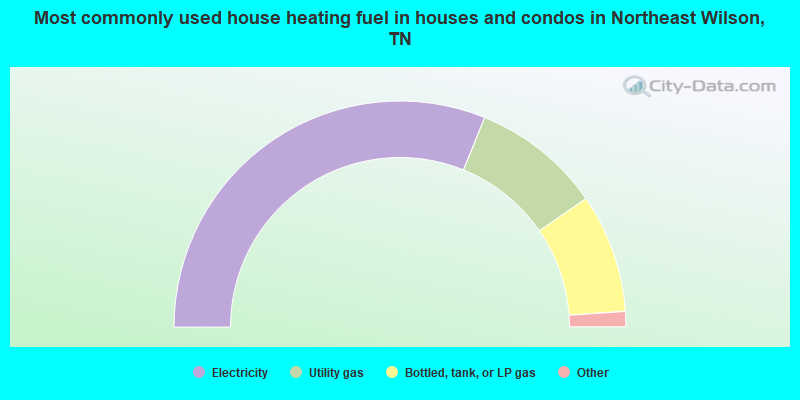
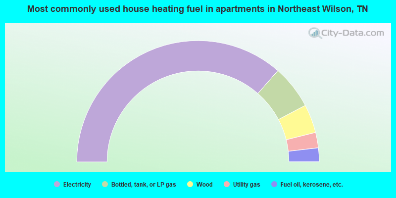
- 62.2%Electricity
- 18.5%Utility gas
- 17.0%Bottled, tank, or LP gas
- 1.6%Wood
- 0.4%Fuel oil, kerosene, etc.
- 0.2%Other fuel
- 72.9%Electricity
- 11.7%Bottled, tank, or LP gas
- 7.6%Wood
- 4.1%Utility gas
- 3.7%Fuel oil, kerosene, etc.
Northeast Wilson compared to Tennessee state average:
- Unemployed percentage significantly below state average.
- Black race population percentage significantly below state average.
- Hispanic race population percentage significantly below state average.
- Foreign-born population percentage significantly below state average.
- Renting percentage significantly below state average.
- Length of stay since moving in significantly above state average.
- Number of rooms per house significantly below state average.
- House age significantly below state average.
Northeast Wilson on our top lists:
- #8 on the list of "Top 101 cities with largest percentage of females in industries: leather and allied products (population 5,000+)"
- #32 on the list of "Top 101 cities with largest percentage of males in occupations: registered nurses (population 5,000+)"
- #44 on the list of "Top 101 cities with largest percentage of females in industries: warehousing and storage (population 5,000+)"
- #56 on the list of "Top 101 cities with largest percentage of males in industries: truck transportation (population 5,000+)"
- #58 on the list of "Top 101 cities with largest percentage of females in industries: paper (population 5,000+)"
- #58 on the list of "Top 101 cities with largest percentage of females in industries: petroleum and petroleum products merchant wholesalers (population 5,000+)"
- #59 on the list of "Top 101 cities with largest percentage of males in industries: farm product raw materials merchant wholesalers (population 5,000+)"
- #70 on the list of "Top 101 cities with largest percentage of females in occupations: laborers and material movers, hand (population 5,000+)"
- #83 on the list of "Top 101 cities with largest percentage of females in occupations: other production occupations including supervisors (population 5,000+)"
- #85 on the list of "Top 101 cities with largest percentage of males in occupations: business operations specialists (population 5,000+)"
- #85 on the list of "Top 101 cities with largest percentage of females in occupations: vehicle and mobile equipment mechanics, installers, and repairers (population 5,000+)"
- #92 on the list of "Top 101 cities with largest percentage of females in occupations: drafters, engineering, and mapping technicians (population 5,000+)"
- #95 on the list of "Top 101 cities with largest percentage of males in industries: paper (population 5,000+)"
- #29 on the list of "Top 101 counties with the largest number of people moving in compared to moving out (pop. 50,000+)"
- #97 on the list of "Top 101 counties with highest percentage of residents voting for Romney (Republican) in the 2012 Presidential Election (pop. 50,000+)"