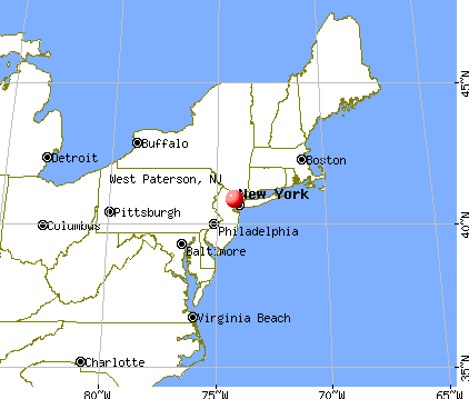
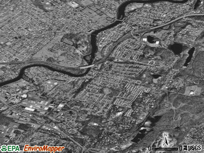
West Paterson, New Jersey

West Paterson: sunflowers

West Paterson: butterfly
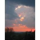
West Paterson: West Paterson- sunset

West Paterson

West Paterson: BEAUTIFUL WEST PATERSON SUMMER SUNSET FROM MY DECK

West Paterson: Grand Canyon

West Paterson: Grand Canyon
West Paterson: Garett Mountain in the fall 2005

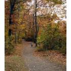
West Paterson: Thanksgiving Morning in the park 2007
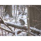
West Paterson: FIRST SNOW OF THE YEAR GARRET MOUNTAIN 2007
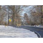
West Paterson: DOE.... ..A ....DEER CROSSING GARRET MOUNTAIN 2007
- see
23
more - add
your


Submit your own pictures of this borough and show them to the world
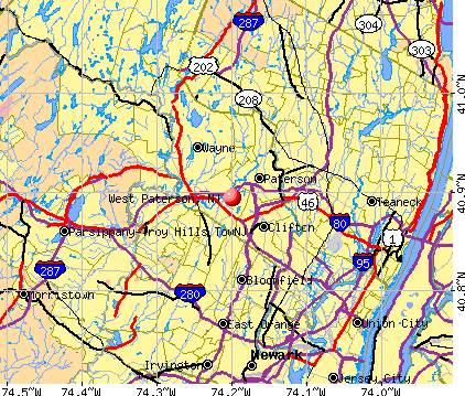
- OSM Map
- General Map
- Google Map
- MSN Map
| Males: 5,247 | |
| Females: 5,656 |
| Median resident age: | 38.1 years |
| New Jersey median age: | 36.7 years |
Zip codes: 07424.
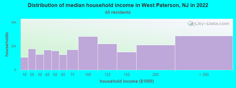
| West Paterson: | $97,930 |
| NJ: | $96,346 |
Estimated per capita income in 2022: $52,242 (it was $29,758 in 2000)
West Paterson borough income, earnings, and wages data
Estimated median house or condo value in 2022: $479,397 (it was $204,400 in 2000)
| West Paterson: | $479,397 |
| NJ: | $428,900 |
Mean prices in 2022: all housing units: $452,665; detached houses: $472,210; townhouses or other attached units: $393,680; in 2-unit structures: $480,413; in 3-to-4-unit structures: $364,785; in 5-or-more-unit structures: $297,736; mobile homes: $421,964
Detailed information about poverty and poor residents in West Paterson, NJ
Compare current foreclosures near West Paterson, NJ:
| Photo | Address | Area | Beds / Baths | Price | Details |
|---|---|---|---|---|---|

|
#1
Horizon Rd Apt 803
Fort Lee, NJ 07024
|
843 sq. feet
|
1 baths 1 beds |
$178,900
|
show details |

|
#2
Forest Ave
Paramus, NJ 07652
|
2,428 sq. feet
|
3 baths 5 beds |
$749,900
|
show details |

|
#3
Washington St Apt 2
Hoboken, NJ 07030
|
1,036 sq. feet
|
1 baths 2 beds |
$409,900
|
show details |

|
#4
Martin Dr
Harrington Park, NJ 07640
|
1,746 sq. feet
|
3 baths 3 beds |
$965,000
|
show details |

|
#5
Bloomfield Ave
Caldwell, NJ 07006
|
1,216 sq. feet
|
2 baths 2 beds |
$400,000
|
show details |

|
#6
Huntington Rd
Union, NJ 07083
|
1,532 sq. feet
|
2 baths 3 beds |
$539,900
|
show details |

|
#7
S Orange Ave
Newark, NJ 07103
|
989 sq. feet
|
1 baths 2 beds |
$289,900
|
show details |

|
#8
Applegate Ave
Elizabeth, NJ 07202
|
808 sq. feet
|
1 baths 2 beds |
$355,000
|
show details |

|
#9
Park Ave Apt 12
North Bergen, NJ 07047
|
835 sq. feet
|
1 baths 2 beds |
$379,900
|
show details |

|
#10
2nd Ave # 5c
New York, NY 10029
|
550 sq. feet
|
1 baths 1 beds |
$448,900
|
show details |
| Photo | Address | Area | Beds / Baths | Price | Details |
|---|---|---|---|---|---|

|
#11
Summer St Apt 5e
Passaic, NJ 07055
|
1,125 sq. feet
|
1 baths 2 beds |
$345,000
|
show details |

|
#12
N Broadway Apt A6
Yonkers, NY 10701
|
950 sq. feet
|
2 baths 2 beds |
$219,900
|
show details |

|
#13
Jersey Ave
Morristown, NJ 07960
|
2,406 sq. feet
|
2 baths 4 beds |
$665,000
|
show details |

|
#14
Grand Concourse Apt 3c
Bronx, NY 10452
|
700 sq. feet
|
1 baths 1 beds |
$184,500
|
show details |

|
#15
E 73rd St
New York, NY 10021
|
1,253 sq. feet
|
2 baths 2 beds |
$715,000
|
show details |

|
#16
Fordham Hill Oval
Bronx, NY 10468
|
700 sq. feet
|
1 baths 1 beds |
$154,900
|
show details |

|
#17
Oakdale Mnr Apt A6d
Suffern, NY 10901
|
750 sq. feet
|
1 baths 1 beds |
$99,900
|
show details |

|
#18
Jersey Ave
Fairview, NJ 07022
|
1,073 sq. feet
|
1 baths 3 beds |
$434,900
|
show details |

|
#19
Ashland Ave
East Orange, NJ 07017
|
2,254 sq. feet
|
1 baths 5 beds |
$272,000
|
show details |

|
#20
Secora Rd Apt G14
Monsey, NY 10952
|
800 sq. feet
|
1 baths 1 beds |
$139,500
|
show details |
| Photo | Address | Area | Beds / Baths | Price | Details |
|---|---|---|---|---|---|

|
#21
Beverly Rd
Oradell, NJ 07649
|
1,200 sq. feet
|
1 baths 3 beds |
$569,900
|
show details |

|
#22
S Beverwyck Rd
Parsippany, NJ 07054
|
895 sq. feet
|
1 baths 3 beds |
$306,800
|
show details |

|
#23
W End Ave Apt 10d
New York, NY 10023
|
- sq. feet
|
1 baths 1 beds |
$429,900
|
show details |

|
#24
Glannon Rd
Livingston, NJ 07039
|
- sq. feet
|
1 baths 3 beds |
$535,600
|
show details |

|
#25
Fifth Street
Hillburn, NY 10931
|
- sq. feet
|
1 baths 3 beds |
$462,800
|
show details |

|
#26
Park Ave # 3w4c
New York, NY 10028
|
- sq. feet
|
4 baths 4 beds |
$8,499,900
|
show details |

|
#27
E 56th St # 1700
New York, NY 10022
|
1,986 sq. feet
|
- baths 2 beds |
$995,000
|
show details |

|
#28
Glenwood Ave Apt 74
Yonkers, NY 10703
|
- sq. feet
|
1 baths 3 beds |
$313,000
|
show details |

|
#29
Blvd E, Apt 34b, Bldg 3
West New York, NJ 07093
|
- sq. feet
|
2 baths 2 beds |
$429,900
|
show details |

|
#30
Arlington Ave Apt 11n
Bronx, NY 10471
|
500 sq. feet
|
- baths 1 beds |
$182,500
|
show details |
| Photo | Address | Area | Beds / Baths | Price | Details |
|---|---|---|---|---|---|

|
#31
N 19th St
East Orange, NJ 07017
|
- sq. feet
|
3 baths 6 beds |
$399,900
|
show details |

|
#32
W 66th St Apt 46g
New York, NY 10023
|
3,637 sq. feet
|
2 baths 1 beds |
show details | |

|
#33
Highland Ave
Passaic, NJ 07055
|
2,018 sq. feet
|
2 baths 4 beds |
show details | |

|
#34
Tudor City Pl Frnt 619
New York, NY 10017
|
500 sq. feet
|
1 baths 1 beds |
show details | |

|
#35
6th St
Hillburn, NY 10931
|
2,469 sq. feet
|
3 baths 5 beds |
show details | |

|
#36
71st St
West New York, NJ 07093
|
1,800 sq. feet
|
3 baths 3 beds |
show details | |

|
#37
Glenview Rd
Nutley, NJ 07110
|
2,173 sq. feet
|
2 baths 3 beds |
show details | |

|
#38
W Clay Ave
Roselle Park, NJ 07204
|
1,974 sq. feet
|
1 baths 3 beds |
show details | |

|
#39
Coit St
Irvington, NJ 07111
|
3,000 sq. feet
|
2 baths 1 beds |
show details | |

|
#40
Southside Ave
Haledon, NJ 07508
|
1,508 sq. feet
|
2 baths 3 beds |
show details |
| Photo | Address | Area | Beds / Baths | Price | Details |
|---|---|---|---|---|---|

|
#41
Pomona Ave
Newark, NJ 07112
|
1,604 sq. feet
|
1 baths 4 beds |
show details | |

|
#42
1st St
Fort Lee, NJ 07024
|
2,603 sq. feet
|
3 baths 3 beds |
show details | |

|
#43
Neptune Ave
Jersey City, NJ 07305
|
2,196 sq. feet
|
3 baths 6 beds |
show details | |

|
#44
Mohawk Trl
Wayne, NJ 07470
|
1,920 sq. feet
|
2 baths 3 beds |
show details | |

|
#45
Alder Ave
Wayne, NJ 07470
|
3,093 sq. feet
|
2 baths 4 beds |
show details | |

|
#46
Pershing Ave
Roselle Park, NJ 07204
|
1,885 sq. feet
|
2 baths 4 beds |
show details | |

|
#47
State Route 10 Bldg
Morris Plains, NJ 07950
|
800 sq. feet
|
1 baths 1 beds |
show details | |

|
#48
Prospect Ave
North Arlington, NJ 07031
|
1,480 sq. feet
|
2 baths 3 beds |
show details | |

|
#49
Harmon Cove Tower # 3
Secaucus, NJ 07094
|
3,210 sq. feet
|
4 baths 4 beds |
show details | |

|
Check over 1 million property listings on Foreclosure.com!
|
browse all offers | |||

- 8,81480.2%White alone
- 1,10510.1%Hispanic
- 4193.8%Asian alone
- 3273.0%Black alone
- 2972.7%Two or more races
- 160.1%Other race alone
- 90.08%American Indian alone
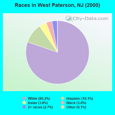
Races in West Paterson detailed stats: ancestries, foreign born residents, place of birth
 Recent articles from our blog. Our writers, many of them Ph.D. graduates or candidates, create easy-to-read articles on a wide variety of topics.


 | Bruce Springsteen busted for DWI at Jersey Shore, official says (278 replies) |
| Whats the best restaurant in New Jersey? (175 replies) |
| Desperately Seeking Lobster Rolls (113 replies) |
| criminals from bad 'hoods committing crime in nicer 'hoods (40 replies) |
| Did you move to NJ and love it? (71 replies) |
| Should Bergen county get rid of blue laws? (139 replies) |
Latest news from West Paterson, NJ collected exclusively by city-data.com from local newspapers, TV, and radio stations
Ancestries: Italian (40.5%), Irish (15.4%), German (10.8%), Polish (7.0%), Arab (2.7%), Dutch (2.7%).
Current Local Time: EST time zone
Incorporated in 1851
Elevation: 330 feet
Land area: 2.96 square miles.
Population density: 3,687 people per square mile (average).
2,312 residents are foreign born (10.9% Europe, 4.7% Asia, 4.6% Latin America).
| This borough: | 21.0% |
| New Jersey: | 17.5% |
| West Paterson borough: | 2.2% ($4,441) |
| New Jersey: | 2.4% ($4,047) |
Nearest city with pop. 50,000+: Paterson, NJ  (2.4 miles , pop. 149,222).
Nearest city with pop. 200,000+: Newark, NJ (11.0 miles , pop. 273,546).
Nearest city with pop. 1,000,000+: Manhattan, NY (14.6 miles , pop. 1,537,195).
Nearest cities:
), ), Latitude: 40.89 N, Longitude: 74.20 W
Daytime population change due to commuting: -734 (-6.7%)
Workers who live and work in this borough: 686 (11.9%)
| Here: | 5.7% |
| New Jersey: | 4.5% |
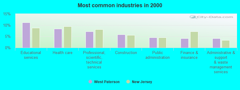
- Educational services (11.1%)
- Health care (8.4%)
- Professional, scientific, technical services (7.1%)
- Construction (5.8%)
- Public administration (4.5%)
- Finance & insurance (4.1%)
- Administrative & support & waste management services (4.1%)
- Construction (9.1%)
- Professional, scientific, technical services (8.0%)
- Public administration (6.6%)
- Educational services (5.0%)
- Accommodation & food services (4.6%)
- Administrative & support & waste management services (4.2%)
- Health care (3.5%)
- Educational services (17.6%)
- Health care (13.5%)
- Professional, scientific, technical services (6.2%)
- Finance & insurance (5.8%)
- Administrative & support & waste management services (4.0%)
- Social assistance (3.0%)
- Accommodation & food services (3.0%)
- Secretaries and administrative assistants (5.2%)
- Other office and administrative support workers, including supervisors (4.5%)
- Other sales and related occupations, including supervisors (4.5%)
- Other management occupations, except farmers and farm managers (4.2%)
- Preschool, kindergarten, elementary, and middle school teachers (4.0%)
- Sales representatives, services, wholesale and manufacturing (3.6%)
- Computer specialists (3.1%)
- Driver/sales workers and truck drivers (4.9%)
- Other management occupations, except farmers and farm managers (4.8%)
- Computer specialists (4.5%)
- Construction traders workers except carpenters, electricians, painters, plumbers, and construction laborers (4.0%)
- Building and grounds cleaning and maintenance occupations (3.9%)
- Other sales and related occupations, including supervisors (3.8%)
- Other production occupations, including supervisors (3.3%)
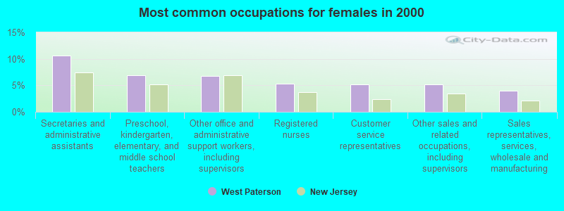
- Secretaries and administrative assistants (10.7%)
- Preschool, kindergarten, elementary, and middle school teachers (6.9%)
- Other office and administrative support workers, including supervisors (6.8%)
- Registered nurses (5.3%)
- Customer service representatives (5.2%)
- Other sales and related occupations, including supervisors (5.2%)
- Sales representatives, services, wholesale and manufacturing (4.0%)
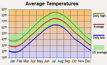
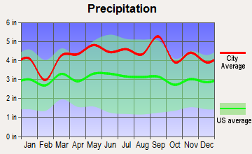
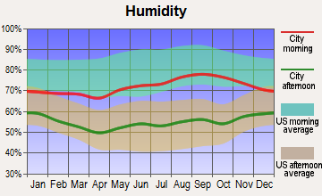
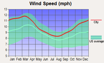
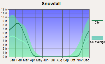
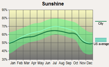
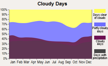
Average climate in West Paterson, New Jersey
Based on data reported by over 4,000 weather stations
|
|

(lower is better)
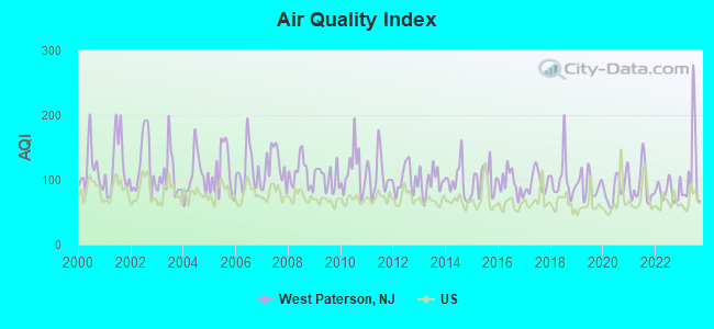
Air Quality Index (AQI) level in 2023 was 113. This is significantly worse than average.
| City: | 113 |
| U.S.: | 73 |
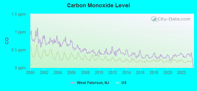
Carbon Monoxide (CO) [ppm] level in 2023 was 0.339. This is worse than average. Closest monitor was 3.3 miles away from the city center.
| City: | 0.339 |
| U.S.: | 0.251 |
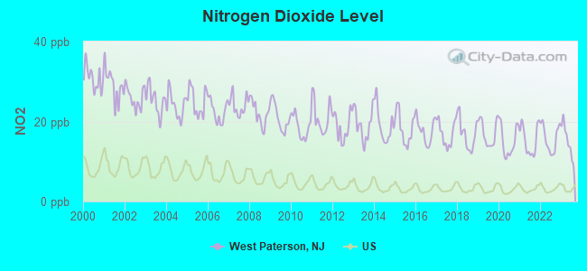
Nitrogen Dioxide (NO2) [ppb] level in 2023 was 15.2. This is significantly worse than average. Closest monitor was 1.7 miles away from the city center.
| City: | 15.2 |
| U.S.: | 5.1 |
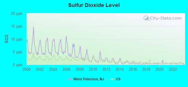
Sulfur Dioxide (SO2) [ppb] level in 2023 was 0.485. This is significantly better than average. Closest monitor was 1.7 miles away from the city center.
| City: | 0.485 |
| U.S.: | 1.515 |
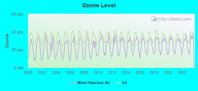
Ozone [ppb] level in 2023 was 29.8. This is about average. Closest monitor was 8.8 miles away from the city center.
| City: | 29.8 |
| U.S.: | 33.3 |
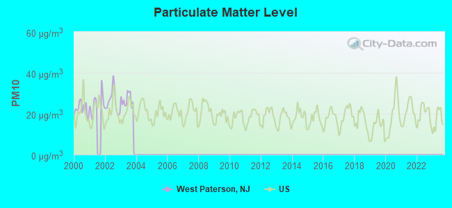
Particulate Matter (PM10) [µg/m3] level in 2003 was 26.9. This is worse than average. Closest monitor was 11.8 miles away from the city center.
| City: | 26.9 |
| U.S.: | 19.2 |

Particulate Matter (PM2.5) [µg/m3] level in 2023 was 9.11. This is about average. Closest monitor was 2.3 miles away from the city center.
| City: | 9.11 |
| U.S.: | 8.11 |
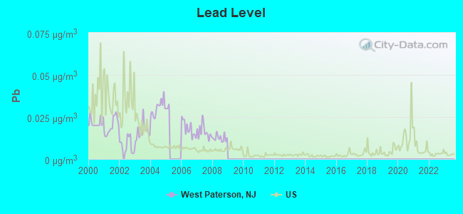
Lead (Pb) [µg/m3] level in 2008 was 0.0125. This is worse than average. Closest monitor was 1.7 miles away from the city center.
| City: | 0.0125 |
| U.S.: | 0.0093 |
Tornado activity:
West Paterson-area historical tornado activity is near New Jersey state average. It is 35% smaller than the overall U.S. average.
On 5/28/1973, a category F3 (max. wind speeds 158-206 mph) tornado 17.0 miles away from the West Paterson borough center caused between $50,000 and $500,000 in damages.
On 5/28/1973, a category F3 tornado 27.4 miles away from the borough center injured 12 people and caused between $50,000 and $500,000 in damages.
Earthquake activity:
West Paterson-area historical earthquake activity is significantly above New Jersey state average. It is 68% smaller than the overall U.S. average.On 8/23/2011 at 17:51:04, a magnitude 5.8 (5.8 MW, Depth: 3.7 mi, Class: Moderate, Intensity: VI - VII) earthquake occurred 287.2 miles away from West Paterson center
On 10/7/1983 at 10:18:46, a magnitude 5.3 (5.1 MB, 5.3 LG, 5.1 ML) earthquake occurred 211.7 miles away from West Paterson center
On 1/16/1994 at 01:49:16, a magnitude 4.6 (4.6 MB, 4.6 LG, Depth: 3.1 mi, Class: Light, Intensity: IV - V) earthquake occurred 104.1 miles away from the city center
On 4/20/2002 at 10:50:47, a magnitude 5.3 (5.3 ML, Depth: 3.0 mi) earthquake occurred 251.6 miles away from the city center
On 4/20/2002 at 10:50:47, a magnitude 5.2 (5.2 MB, 4.2 MS, 5.2 MW, 5.0 MW) earthquake occurred 249.7 miles away from West Paterson center
On 1/16/1994 at 00:42:43, a magnitude 4.2 (4.2 MB, 4.0 LG, Depth: 3.1 mi) earthquake occurred 102.7 miles away from West Paterson center
Magnitude types: regional Lg-wave magnitude (LG), body-wave magnitude (MB), local magnitude (ML), surface-wave magnitude (MS), moment magnitude (MW)
Natural disasters:
The number of natural disasters in Passaic County (27) is a lot greater than the US average (15).Major Disasters (Presidential) Declared: 16
Emergencies Declared: 10
Causes of natural disasters: Hurricanes: 7, Floods: 6, Storms: 5, Heavy Rains: 3, Snowstorms: 3, Blizzards: 2, Water Shortages: 2, Winter Storms: 2, Power Outage: 1, Tornado: 1, Tropical Storm: 1, Wind: 1, Other: 3 (Note: some incidents may be assigned to more than one category).
Main business address for: CYTEC INDUSTRIES INC/DE/ (MISCELLANEOUS CHEMICAL PRODUCTS).
Hospitals and medical centers near West Paterson:
- WOODLAND PARK DIALYSIS CENTER (Dialysis Facility, about 1 miles away; WOODLAND PARK, NJ)
- VALLEY REST NH (Nursing Home, about 1 miles away; TOTOWA, NJ)
- VALLEY REST NURSING HOME (Nursing Home, about 1 miles away; TOTOWA BORO, NJ)
- ST JOSEPH'S HOME FOR ELDERLY (Nursing Home, about 2 miles away; TOTOWA, NJ)
- KEW GARDENS DIALYSIS CENTER (Dialysis Facility, about 2 miles away; KEW GARDENS, NY)
- DOLLY MOUNT NURSING HOME (Nursing Home, about 2 miles away; CLIFTON, NJ)
- DOCTORS SUBACUTE CARE (Nursing Home, about 2 miles away; PATERSON, NJ)
Amtrak stations near West Paterson:
- 12 miles: NEWARK (RAYMOND PLAZA WEST) . Services: ticket office, fully wheelchair accessible, enclosed waiting area, public restrooms, public payphones, snack bar, ATM, paid short-term parking, paid long-term parking, call for car rental service, taxi stand, intercity bus service, public transit connection.
- 14 miles: NEWARK INTERNATIONAL AIRPORT (NEWARK, ) . Services: ticket office, enclosed waiting area, public restrooms, public payphones.
- 15 miles: NEW YORK (PENN STA) (NEW YORK, 7TH AVE. & W. 32ND ST.) . Services: ticket office, fully wheelchair accessible, enclosed waiting area, public restrooms, public payphones, full-service food facilities, snack bar, vending machines, ATM, paid short-term parking, paid long-term parking, call for car rental service, taxi stand, public transit connection.
Colleges/universities with over 2000 students nearest to West Paterson:
- Berkeley College-Woodland Park (about 1 miles; Woodland Park, NJ; Full-time enrollment: 2,938)
- Passaic County Community College (about 3 miles; Paterson, NJ; FT enrollment: 6,351)
- Montclair State University (about 3 miles; Montclair, NJ; FT enrollment: 16,277)
- William Paterson University of New Jersey (about 4 miles; Wayne, NJ; FT enrollment: 10,198)
- Bergen Community College (about 7 miles; Paramus, NJ; FT enrollment: 11,826)
- Jersey College (about 8 miles; Teterboro, NJ; FT enrollment: 2,073)
- Fairleigh Dickinson University-Metropolitan Campus (about 9 miles; Teaneck, NJ; FT enrollment: 5,349)
User-submitted facts and corrections:
- Berkeley College Garret Mountain Campus is located in West Paterson, NJ www.berkeleycollege.edu
Points of interest:
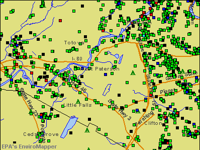
Notable locations in West Paterson: Pulse Medical Transportation (A), West Paterson First Aid Squad (B), West Paterson Fire Department West Park Hose Company 1 (C), West Paterson Fire Department Rifle Camp Fire Company 3 (D), West Paterson Fire Department Passaic Valley Hose Company 2 (E), West Paterson Youth Center (F), West Paterson Engine Company Number 1 (G), West Paterson Community Building (H). Display/hide their locations on the map
Main business address in West Paterson: CYTEC INDUSTRIES INC/DE/ (A). Display/hide its location on the map
Lakes and reservoirs: Butchers Pond (A), Barbour Pond (B), Highland Lake (C), Great Notch Reservoir (D), New Street Reservoir (E). Display/hide their locations on the map
Streams, rivers, and creeks: Peckman River (A), Pearl Brook (B). Display/hide their locations on the map
Parks in West Paterson include: Garrett Mountain Reservation (1), Frank D Zaccaria Memorial Park (2), Memorial Park (3). Display/hide their locations on the map
| This borough: | 2.5 people |
| New Jersey: | 2.7 people |
| This borough: | 68.8% |
| Whole state: | 70.7% |
| This borough: | 5.0% |
| Whole state: | 4.9% |
Likely homosexual households (counted as self-reported same-sex unmarried-partner households)
- Lesbian couples: 0.3% of all households
- Gay men: 0.2% of all households
| This borough: | 3.4% |
| Whole state: | 8.5% |
| This borough: | 1.2% |
| Whole state: | 4.2% |
3 people in religious group quarters in 2000
Banks with branches in West Paterson (2011 data):
- PNC Bank, National Association: West Paterson Branch at 1260 Mcbride Avenue, branch established on 1956/09/18; Garret Mountain Plaza Branch at One Garret Mountain Plaza, branch established on 1861/05/01. Info updated 2012/03/20: Bank assets: $263,309.6 mil, Deposits: $197,343.0 mil, headquarters in Wilmington, DE, positive income, Commercial Lending Specialization, 3085 total offices, Holding Company: Pnc Financial Services Group, Inc., The
- JPMorgan Chase Bank, National Association: Prospect Park Branch at 989 Mcbride Avenue, branch established on 1991/04/19. Info updated 2011/11/10: Bank assets: $1,811,678.0 mil, Deposits: $1,190,738.0 mil, headquarters in Columbus, OH, positive income, International Specialization, 5577 total offices, Holding Company: Jpmorgan Chase & Co.
- BNY Mellon, National Association: West Paterson Branch at 385 Rifle Camp Rd, branch established on 2002/11/01. Info updated 2012/02/29: Bank assets: $14,749.3 mil, Deposits: $11,797.5 mil, headquarters in Pittsburgh, PA, positive income, 20 total offices, Holding Company: Bank Of New York Mellon Corporation, The
- TD Bank, National Association: Rt 46 & Mcbride Avenue Branch at Rt 46 & Mcbride Avenue, branch established on 1887/01/01. Info updated 2010/10/04: Bank assets: $188,912.6 mil, Deposits: $153,149.8 mil, headquarters in Wilmington, DE, positive income, 1314 total offices, Holding Company: Toronto-Dominion Bank, The
For population 15 years and over in West Paterson:
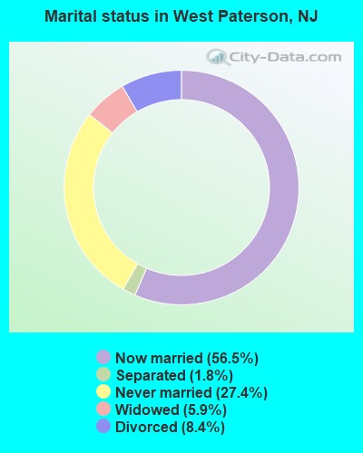
- Never married: 27.4%
- Now married: 56.5%
- Separated: 1.8%
- Widowed: 5.9%
- Divorced: 8.4%
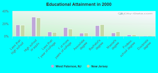
For population 25 years and over in West Paterson:
- High school or higher: 81.8%
- Bachelor's degree or higher: 25.2%
- Graduate or professional degree: 8.2%
- Unemployed: 3.4%
- Mean travel time to work (commute): 23.5 minutes
| Here: | 13.5 |
| New Jersey average: | 13.1 |
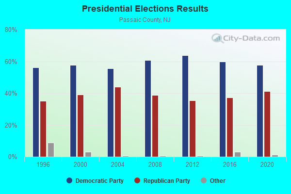
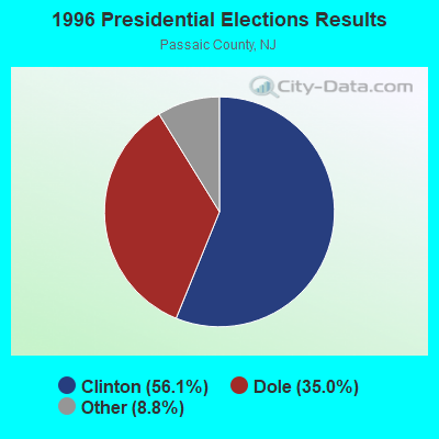
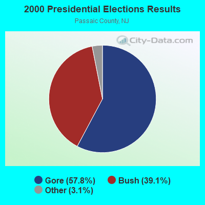
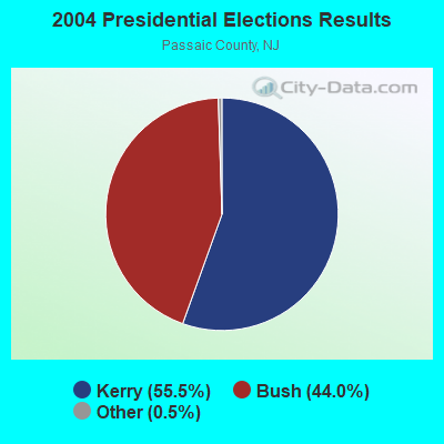
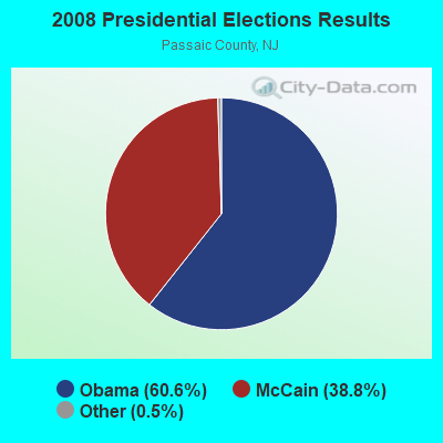
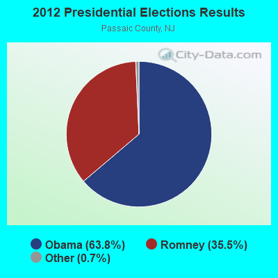
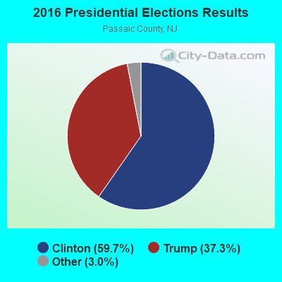

Graphs represent county-level data. Detailed 2008 Election Results
Religion statistics for West Paterson, NJ (based on Passaic County data)
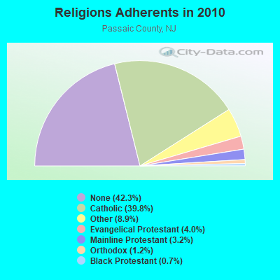
| Religion | Adherents | Congregations |
|---|---|---|
| Catholic | 199,315 | 56 |
| Other | 44,397 | 51 |
| Evangelical Protestant | 20,164 | 110 |
| Mainline Protestant | 15,796 | 83 |
| Orthodox | 5,990 | 14 |
| Black Protestant | 3,610 | 16 |
| None | 211,954 | - |
Food Environment Statistics:
| Passaic County: | 4.33 / 10,000 pop. |
| New Jersey: | 2.90 / 10,000 pop. |
| Passaic County: | 0.04 / 10,000 pop. |
| New Jersey: | 0.06 / 10,000 pop. |
| Passaic County: | 1.31 / 10,000 pop. |
| State: | 1.76 / 10,000 pop. |
| Passaic County: | 0.65 / 10,000 pop. |
| New Jersey: | 0.81 / 10,000 pop. |
| This county: | 5.72 / 10,000 pop. |
| New Jersey: | 7.15 / 10,000 pop. |
| Passaic County: | 8.1% |
| New Jersey: | 8.3% |
| Here: | 24.7% |
| New Jersey: | 23.3% |
| Passaic County: | 18.3% |
| New Jersey: | 18.0% |
| Local government employment and payroll (March 2007) | |||||
| Function | Full-time employees | Monthly full-time payroll | Average yearly full-time wage | Part-time employees | Monthly part-time payroll |
|---|---|---|---|---|---|
| Police Protection - Officers | 25 | $181,740 | $87,235 | 0 | $0 |
| Streets and Highways | 13 | $60,154 | $55,527 | 0 | $0 |
| Police - Other | 5 | $12,168 | $29,203 | 17 | $4,350 |
| Local Libraries | 5 | $12,982 | $31,157 | 5 | $2,338 |
| Other Government Administration | 4 | $17,724 | $53,172 | 7 | $3,795 |
| Financial Administration | 4 | $11,626 | $34,878 | 2 | $2,925 |
| Other and Unallocable | 3 | $16,914 | $67,656 | 5 | $3,112 |
| Judicial and Legal | 2 | $5,936 | $35,616 | 6 | $4,971 |
| Sewerage | 2 | $11,824 | $70,944 | 0 | $0 |
| Water Supply | 0 | $0 | 0 | $0 | |
| Electric Power | 0 | $0 | 0 | $0 | |
| Gas Supply | 0 | $0 | 0 | $0 | |
| Transit | 0 | $0 | 0 | $0 | |
| Firefighters | 0 | $0 | 0 | $0 | |
| Health | 0 | $0 | 2 | $1,893 | |
| Airports | 0 | $0 | 0 | $0 | |
| Solid Waste Management | 0 | $0 | 3 | $2,090 | |
| Parks and Recreation | 0 | $0 | 0 | $0 | |
| Housing and Community Development (Local) | 0 | $0 | 0 | $0 | |
| Natural Resources | 0 | $0 | 0 | $0 | |
| Water Transport and Terminals | 0 | $0 | 0 | $0 | |
| Correction | 0 | $0 | 0 | $0 | |
| Fire - Other | 0 | $0 | 4 | $3,928 | |
| Welfare | 0 | $0 | 1 | $680 | |
| Hospitals | 0 | $0 | 0 | $0 | |
| Totals for Government | 63 | $331,068 | $63,061 | 52 | $30,082 |
5.27% of this county's 2021 resident taxpayers lived in other counties in 2020 ($68,330 average adjusted gross income)
| Here: | 5.27% |
| New Jersey average: | 6.70% |
0.02% of residents moved from foreign countries ($18 average AGI)
Passaic County: 0.02% New Jersey average: 0.01%
Top counties from which taxpayers relocated into this county between 2020 and 2021:
| from Bergen County, NJ | |
| from Essex County, NJ | |
| from Hudson County, NJ |
6.56% of this county's 2020 resident taxpayers moved to other counties in 2021 ($73,505 average adjusted gross income)
| Here: | 6.56% |
| New Jersey average: | 7.02% |
0.01% of residents moved to foreign countries ($57 average AGI)
Passaic County: 0.01% New Jersey average: 0.02%
Top counties to which taxpayers relocated from this county between 2020 and 2021:
| to Bergen County, NJ | |
| to Morris County, NJ | |
| to Essex County, NJ |
| Businesses in West Paterson, NJ | ||||
| Name | Count | Name | Count | |
|---|---|---|---|---|
| 7-Eleven | 1 | Nike | 2 | |
| Decora Cabinetry | 2 | On The Border | 1 | |
| Domino's Pizza | 1 | Payless | 1 | |
| Dunkin Donuts | 3 | Pizza Hut | 1 | |
| FedEx | 2 | Subway | 1 | |
| GameStop | 1 | UPS | 5 | |
| MasterBrand Cabinets | 5 | |||
Strongest AM radio stations in West Paterson:
- WABC (770 AM; 50 kW; NEW YORK, NY; Owner: WABC-AM RADIO, INC.)
- WOR (710 AM; 50 kW; NEW YORK, NY; Owner: BUCKLEY BROADCASTING CORPORATION)
- WINS (1010 AM; 50 kW; NEW YORK, NY; Owner: INFINITY BROADCASTING OPERATIONS, INC.)
- WMCA (570 AM; 50 kW; NEW YORK, NY; Owner: SALEM MEDIA OF NEW YORK, LLC)
- WADO (1280 AM; 50 kW; NEW YORK, NY; Owner: WADO-AM LICENSE CORP.)
- WSNR (620 AM; 20 kW; JERSEY CITY, NJ)
- WEPN (1050 AM; 50 kW; NEW YORK, NY; Owner: NEW YORK AM RADIO, LLC)
- WPAT (930 AM; 5 kW; PATERSON, NJ; Owner: WPAT, INC)
- WBBR (1130 AM; 50 kW; NEW YORK, NY; Owner: BLOOMBERG COMMUNICATIONS INC.)
- WLIB (1190 AM; 30 kW; NEW YORK, NY; Owner: ICBC BROADCAST HOLDINGS-NY, INC.)
- WWRL (1600 AM; 25 kW; NEW YORK, NY; Owner: ACCESS.1 COMMUNICATIONS CORP.-NY)
- WFAN (660 AM; 50 kW; NEW YORK, NY; Owner: INFINITY BROADCASTING OPERATIONS, INC.)
- WVNJ (1160 AM; 20 kW; OAKLAND, NJ; Owner: UNIVERSAL B/CASTING OF NEW YORK,INC.)
Strongest FM radio stations in West Paterson:
- WMSC (90.3 FM; UPPER MONTCLAIR, NJ; Owner: MONTCLAIR STATE UNIVERSITY)
- WNEW (102.7 FM; NEW YORK, NY; Owner: INFINITY BROADCASTING OPERATIONS, INC.)
- WRKS (98.7 FM; NEW YORK, NY; Owner: EMMIS RADIO LICENSE CORP OF NEW YORK)
- WKCR-FM (89.9 FM; NEW YORK, NY; Owner: TRUSTEES OF COLUMBIA UNIVERSITY IN NEW YORK)
- WKTU (103.5 FM; LAKE SUCCESS, NY; Owner: AMFM RADIO LICENSES, LLC)
- WQCD (101.9 FM; NEW YORK, NY; Owner: EMMIS RADIO LICENSE CORPORATION)
- WAXQ (104.3 FM; NEW YORK, NY; Owner: AMFM NEW YORK LICENSES, LLC)
- WHTZ (100.3 FM; NEWARK, NJ; Owner: AMFM RADIO LICENSES, L.L.C.)
- WWPR-FM (105.1 FM; NEW YORK, NY; Owner: AMFM RADIO LICENSES, L.L.C.)
- WCBS-FM (101.1 FM; NEW YORK, NY; Owner: INFINITY BROADCASTING OPERATIONS, INC.)
- WCAA (105.9 FM; NEWARK, NJ; Owner: WADO-AM LICENSE CORP. ("WADO"))
- WBAI (99.5 FM; NEW YORK, NY; Owner: PACIFICA FOUNDATION, INC.)
- WBLS (107.5 FM; NEW YORK, NY; Owner: ICBC BROADCAST HOLDINGS-NY, INC.)
- WLTW (106.7 FM; NEW YORK, NY; Owner: AMFM NEW YORK LICENSES, LLC)
- WQXR-FM (96.3 FM; NEW YORK, NY; Owner: THE NEW YORK TIMES ELECTRONIC MEDIA COMPANY)
- WSKQ-FM (97.9 FM; NEW YORK, NY; Owner: WSKQ LICENSING, INC.)
- WXRK (92.3 FM; NEW YORK, NY; Owner: INFINITY BROADCASTING OPERATIONS, INC.)
- WFME (94.7 FM; NEWARK, NJ; Owner: FAMILY STATIONS, INC.)
- WQHT (97.1 FM; NEW YORK, NY; Owner: EMMIS LICENSE CORPORATION OF NEW YORK)
- WNYC-FM (93.9 FM; NEW YORK, NY; Owner: WNYC RADIO)
TV broadcast stations around West Paterson:
- WPXO-LP (Channel 34; EAST ORANGE, NJ; Owner: PAXSON COMMUNICATIONS LPTV, INC.)
- WNYW (Channel 5; NEW YORK, NY; Owner: FOX TELEVISION STATIONS, INC.)
- WCBS-TV (Channel 2; NEW YORK, NY; Owner: CBS BROADCASTING INC.)
- WABC-TV (Channel 7; NEW YORK, NY; Owner: AMERICAN BROADCASTING COMPANIES, INC)
- WPIX (Channel 11; NEW YORK, NY; Owner: WPIX, INC.)
- WWOR-TV (Channel 9; SECAUCUS, NJ; Owner: FOX TELEVISION STATIONS, INC.)
- WNJU (Channel 47; LINDEN, NJ; Owner: WNJU LICENSE CORPORATION)
- WPXN-TV (Channel 31; NEW YORK, NY; Owner: PAXSON COMMUNICATIONS LICENSE COMPANY, LLC)
- WFUT (Channel 68; NEWARK, NJ; Owner: UNIVISION NEW YORK LLC)
- WNBC (Channel 4; NEW YORK, NY; Owner: NATIONAL BROADCASTING COMPANY, INC.)
- WNET (Channel 13; NEWARK, NJ; Owner: EDUCATIONAL BROADCASTING CORPORATION)
- WXTV (Channel 41; PATERSON, NJ; Owner: WXTV LICENSE PARTNERSHIP, G.P.)
- WNYE-TV (Channel 25; NEW YORK, NY; Owner: NEW YORK CITY BOARD OF EDUCATION)
- WXNY-LP (Channel 32; NEW YORK, NY; Owner: ISLAND BROADCASTING COMPANY)
- WKOB-LP (Channel 53; NEW YORK, NY; Owner: WKOB COMMUNICATIONS, INC.)
- WEBR-CA (Channel 17; MANHATTAN, NY; Owner: K LICENSEE INC.)
- WRNN-LP (Channel 57; NYACK, NY; Owner: LP NYACK LIMITED PARTNERSHIP)
- WFME-TV (Channel 66; WEST MILFORD, NJ; Owner: FAMILY STATIONS, INC.)
- W60AI (Channel 60; NEW YORK, NY; Owner: VENTANA TELEVISION, INC.)
- W68DN (Channel 68; CHERRY HILL, ETC., NJ; Owner: MARCIA COHEN)
- WNXY-LP (Channel 26; NEW YORK, NY; Owner: ISLAND BROADCASTING COMPANY)
- W33BS (Channel 33; DARIEN, CT; Owner: CT&T BROADCASTING, INC.)
- WNYN-LP (Channel 39; NEW YORK, NY; Owner: ISLAND BROADCASTING COMPANY)
- WNYX-LP (Channel 35; NEW YORK, NY; Owner: ISLAND BROADCASTING COMPANY)
- WMBC-TV (Channel 63; NEWTON, NJ; Owner: MOUNTAIN BROADCASTING CORPORATION)
- National Bridge Inventory (NBI) Statistics
- 8Number of bridges
- 46ft / 14.3mTotal length
- $6,192,000Total costs
- 316,576Total average daily traffic
- 12,640Total average daily truck traffic
FCC Registered Antenna Towers:
4- MARIN FETTMAN, Washington Dr. (Nj05538c) (Lat: 40.885944 Lon: -74.193722), Type: 29.9, Overall height: 29.9 m, Registrant: T-Mobile Northeast LLC, Marin.Fettman@t-Mobile.Com, , Belle-vue, Phone: (425) 383-4000
- Dan Menser, Washington Dr. (Nj05538c) (Lat: 40.885944 Lon: -74.193722), Type: 29.9, Overall height: 29.9 m, Registrant: T-Mobile Northeast LLC, Fccasrrequest@t-Mobile.Com, , Belle-vue, Phone: (425) 383-5178
- DAN MENSER, Washington Dr. (Nj05538c) (Lat: 40.885944 Lon: -74.193722), Type: 29.9, Overall height: 29.9 m, Registrant: T-Mobile Northeast LLC, Fccasrrequest@t-Mobile.Com, , Belle-vue, Phone: (425) 383-5178
- Shannon Reilly Kraus, Washington Dr. (Nj05538c) (Lat: 40.885944 Lon: -74.193722), Type: 29.9, Overall height: 29.9 m, Registrant: T-Mobile Northeast LLC, Fccregulatorycompliancecontact@t-Mobile.Com, , Belle-vue, Phone: (425) 383-8401
FCC Registered Private Land Mobile Towers:
1 (See the full list of FCC Registered Private Land Mobile Towers in West Paterson, NJ)FCC Registered Broadcast Land Mobile Towers:
11 (See the full list of FCC Registered Broadcast Land Mobile Towers)FCC Registered Microwave Towers:
4- STATION, Within 17.5 Mi Radius Of (Lat: 40.886472 Lon: -74.193194), Overall height: 6.1 m, Call Sign: WNTE849,
Assigned Frequencies: 18865.0 MHz, 19205.0 MHz, Grant Date: 08/23/1995, Expiration Date: 08/23/2000, Cancellation Date: 12/03/2000, Phone: (202) 371-6940
- STATION, 1000 Ft E Of Rifle Camp Rd (Lat: 40.880639 Lon: -74.193194), Overall height: 59.4 m, Call Sign: WNTQ239,
Assigned Frequencies: 952.131 MHz, 928.131 MHz, Grant Date: 09/10/2002, Expiration Date: 10/30/2012, Cancellation Date: 01/05/2013, Phone: (202) 331-9495
- NJY0212, 3 Garret Mountain Plz (Lat: 40.902806 Lon: -74.191889), Type: Bant, Structure height: 15.2 m, Overall height: 15.4 m, Call Sign: WQEN452, Licensee ID: L01728370,
Assigned Frequencies: 18120.0 MHz, Grant Date: 03/10/2006, Expiration Date: 03/10/2016, Cancellation Date: 09/10/2013, Certifier: Joseph M Sandri Jr., Registrant: Fibertower Network Services, Corp., Debtor-In-Possession, 1875 Eye Street, Nw, 5th Floor, Room 505, Washington, DC 20006, Phone: (202) 223-1028, Email:
- NJ-NNJ5923A, 1 Garret Mountain Plaza (Lat: 40.904222 Lon: -74.189083), Type: Bant, Structure height: 40.6 m, Overall height: 43.6 m, Call Sign: WQLT759,
Assigned Frequencies: 17815.0 MHz, 23325.0 MHz, 17915.0 MHz, 23425.0 MHz, 23025.0 MHz, Grant Date: 07/08/2020, Expiration Date: 04/22/2030, Cancellation Date: 09/13/2021, Certifier: Nadja S Sodos-Wallace, Registrant: T-Mobile Usa, Inc., 12920 Se 38th Street, Bellevue, WA 98006, Phone: (425) 383-8402, Fax: (425) 383-4840, Email:
FCC Registered Paging Towers:
2- Riffle Comp Road, Garrett Mountain (Lat: 40.893694 Lon: -74.184861), Call Sign: KNKJ998,
Assigned Frequencies: 931.362 MHz, Grant Date: 04/19/1999, Expiration Date: 04/01/2009, Cancellation Date: 10/28/2004, Certifier: Kenneth Goldstein, Registrant: Alston & Bird LLP, 601 Pennsylvania Ave., Nw, North Building, 10th Floor, Washington, DC 20004, Phone: (202) 756-3376, Fax: (202) 756-3333, Email:
- North Tip Of Garrett Mountain, 79 Garrett Street (Lat: 40.905083 Lon: -74.181250), Call Sign: KEJ891,
Assigned Frequencies: 454.075 MHz, Grant Date: 05/29/2019, Expiration Date: 04/01/2029, Certifier: Robert C Knapp, Registrant: Zcall.Com, Inc., 24 Rockdale Road, West Haven, CT 06516, Phone: (800) 343-9333, Fax: (203) 933-2259, Email:
FCC Registered Amateur Radio Licenses:
21 (See the full list of FCC Registered Amateur Radio Licenses in West Paterson)FAA Registered Aircraft:
1- Aircraft: CESSNA 172M (Category: Land, Seats: 4, Weight: Up to 12,499 Pounds, Speed: 108 mph), Engine: LYCOMING 0-320 SERIES (180 HP) (4 Cycle)
N-Number: 80419, N80419, N-80419, Serial Number: 17266578, Year manufactured: 1976, Airworthiness Date: 01/23/1976, Certificate Issue Date: 01/23/1992
Registrant (Individual): Lawrence K Korona, 5 Lozrovich Place, West Paterson, NJ 07424
| Home Mortgage Disclosure Act Aggregated Statistics For Year 2009 (Based on 1 full tract) | ||||||||||
| A) FHA, FSA/RHS & VA Home Purchase Loans | B) Conventional Home Purchase Loans | C) Refinancings | D) Home Improvement Loans | F) Non-occupant Loans on < 5 Family Dwellings (A B C & D) | ||||||
|---|---|---|---|---|---|---|---|---|---|---|
| Number | Average Value | Number | Average Value | Number | Average Value | Number | Average Value | Number | Average Value | |
| LOANS ORIGINATED | 36 | $330,889 | 52 | $275,712 | 183 | $257,131 | 8 | $113,750 | 13 | $272,077 |
| APPLICATIONS APPROVED, NOT ACCEPTED | 5 | $318,400 | 4 | $210,000 | 20 | $286,850 | 2 | $205,000 | 0 | $0 |
| APPLICATIONS DENIED | 8 | $349,750 | 13 | $234,462 | 116 | $301,802 | 16 | $62,000 | 8 | $280,250 |
| APPLICATIONS WITHDRAWN | 4 | $328,750 | 11 | $281,000 | 56 | $290,411 | 2 | $31,000 | 2 | $230,000 |
| FILES CLOSED FOR INCOMPLETENESS | 2 | $369,000 | 2 | $307,000 | 13 | $289,769 | 0 | $0 | 0 | $0 |
Detailed HMDA statistics for the following Tracts: 2641.00
| Private Mortgage Insurance Companies Aggregated Statistics For Year 2009 (Based on 1 full tract) | ||||
| A) Conventional Home Purchase Loans | B) Refinancings | |||
|---|---|---|---|---|
| Number | Average Value | Number | Average Value | |
| LOANS ORIGINATED | 5 | $314,400 | 1 | $406,000 |
| APPLICATIONS APPROVED, NOT ACCEPTED | 1 | $266,000 | 0 | $0 |
| APPLICATIONS DENIED | 2 | $315,000 | 5 | $334,800 |
| APPLICATIONS WITHDRAWN | 0 | $0 | 0 | $0 |
| FILES CLOSED FOR INCOMPLETENESS | 0 | $0 | 0 | $0 |
Detailed PMIC statistics for the following Tracts: 2641.00
2003 - 2018 National Fire Incident Reporting System (NFIRS) incidents
- Fire incident types reported to NFIRS in West Paterson, NJ
- 11649.4%Structure Fires
- 5423.0%Mobile Property/Vehicle Fires
- 5021.3%Outside Fires
- 156.4%Other
 According to the data from the years 2003 - 2018 the average number of fires per year is 15. The highest number of fire incidents - 54 took place in 2007, and the least - 0 in 2012. The data has a dropping trend.
 When looking into fire subcategories, the most reports belonged to: Structure Fires (49.4%), and Mobile Property/Vehicle Fires (23.0%).
- 77.3%Utility gas
- 17.8%Fuel oil, kerosene, etc.
- 3.5%Electricity
- 1.1%Bottled, tank, or LP gas
- 0.4%Other fuel
- 83.9%Utility gas
- 8.0%Fuel oil, kerosene, etc.
- 3.7%Electricity
- 1.6%Bottled, tank, or LP gas
- 1.4%Other fuel
- 1.3%No fuel used
West Paterson compared to New Jersey state average:
- Unemployed percentage significantly below state average.
- Black race population percentage significantly below state average.
- Hispanic race population percentage below state average.
- Renting percentage significantly below state average.
- Length of stay since moving in significantly above state average.
- Number of rooms per house significantly below state average.
- House age significantly below state average.
- Institutionalized population percentage significantly above state average.
West Paterson on our top lists:
- #6 on the list of "Top 101 cities with largest percentage of males in industries: personal and laundry services (population 5,000+)"
- #11 on the list of "Top 101 cities with largest percentage of males in industries: clothing and accessories, including shoe, stores (population 5,000+)"
- #15 on the list of "Top 101 cities with largest percentage of males in occupations: motor vehicle operators except bus and truck drivers (population 5,000+)"
- #16 on the list of "Top 101 cities with largest percentage of males in occupations: occupational and physical therapist assistants and aides (population 5,000+)"
- #19 on the list of "Top 101 cities with largest percentage of females in occupations: customer service representatives (population 5,000+)"
- #19 on the list of "Top 101 cities with largest percentage of females in industries: professional and commercial equipment and supplies merchant wholesalers (population 5,000+)"
- #27 on the list of "Top 101 cities with largest percentage of males in occupations: personal appearance workers (population 5,000+)"
- #33 on the list of "Top 101 cities with largest percentage of females in occupations: secretaries and administrative assistants (population 5,000+)"
- #35 on the list of "Top 101 cities with largest percentage of males in occupations: textile, apparel, and furnishings workers (population 5,000+)"
- #40 on the list of "Top 101 cities with largest percentage of males in industries: miscellaneous nondurable goods merchant wholesalers (population 5,000+)"
- #55 on the list of "Top 101 cities with largest percentage of females in industries: radio, tv, and computer stores (population 5,000+)"
- #61 on the list of "Top 101 cities with largest percentage of females in industries: publishing, and motion picture and sound recording industries (population 5,000+)"
- #69 on the list of "Top 101 cities with largest percentage of females in industries: furniture and home furnishings, and household appliance stores (population 5,000+)"
- #75 on the list of "Top 101 cities with largest percentage of males in industries: music stores (population 5,000+)"
- #80 on the list of "Top 101 cities with largest percentage of males in industries: food (population 5,000+)"
- #84 on the list of "Top 101 cities with largest percentage of females in industries: health and personal care, except drug, stores (population 5,000+)"
- #86 on the list of "Top 101 cities with largest percentage of females in industries: fuel dealers (population 5,000+)"
- #93 on the list of "Top 101 cities with largest percentage of females in industries: apparel (population 5,000+)"
- #93 on the list of "Top 101 cities with largest percentage of females in industries: jewelry, luggage, and leather goods stores (population 5,000+)"
- #93 on the list of "Top 101 cities with largest percentage of males in industries: other transportation, and support activities, and couriers (population 5,000+)"
- #96 (07424) on the list of "Top 101 zip codes with the largest percentage of Arab first ancestries"
- #19 on the list of "Top 101 counties with the lowest percentage of residents that exercised in the past month"
- #22 on the list of "Top 101 counties with the largest number of people moving out compared to moving in (pop. 50,000+)"
- #23 on the list of "Top 101 counties with the largest decrease in the number of infant deaths per 1000 residents 2000-2006 to 2007-2013 (pop. 50,000+)"
- #24 on the list of "Top 101 counties with the highest surface withdrawal of fresh water for public supply (pop. 50,000+)"
- #25 on the list of "Top 101 counties with the lowest percentage of residents that keep firearms around their homes"

|
|
Total of 9 patent applications in 2008-2024.