Bridge Statistics for Alamogordo, New Mexico (NM)
Condition, Traffic, Stress, Structural Evaluation, Project Costs
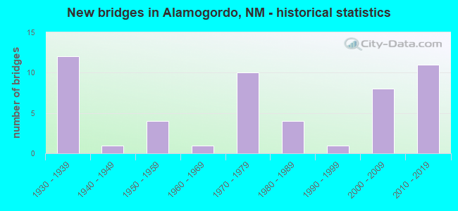
- New bridges - historical statistics
- 121930-1939
- 11940-1949
- 41950-1959
- 11960-1969
- 101970-1979
- 41980-1989
- 11990-1999
- 82000-2009
- 112010-2019
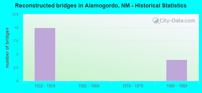
- Reconstructed bridges - Historical Statistics
- 101950-1959
- 01960-1969
- 01970-1979
- 41980-1989
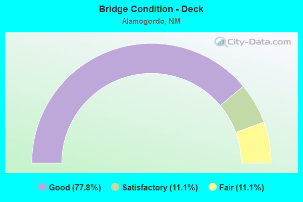
- Bridge Condition - Deck
- 77.8%Good
- 11.1%Satisfactory
- 11.1%Fair
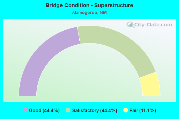
- Bridge Condition - Superstructure
- 44.4%Good
- 44.4%Satisfactory
- 11.1%Fair

- Bridge Condition - Substructure
- 44.4%Good
- 33.3%Satisfactory
- 22.2%Fair
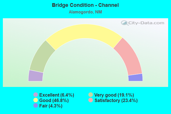
- Bridge Condition - Channel
- 6.4%Excellent
- 19.1%Very good
- 46.8%Good
- 23.4%Satisfactory
- 4.3%Fair
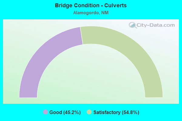
- Bridge Condition - Culverts
- 45.2%Good
- 54.8%Satisfactory
Find on map >> Show street view
Structure Number: 2185, Location: 0.5 M N JCT US70/ALAMOGOR (Lat: 32.875386, Lng: -105.962164), Route carried "on" structure: US 4923, Year Built: 1934, Year Reconstructed: 1955, Status: Open, Structure Length: 0.98m (3.22ft), Average Daily Traffic: 16,142 (year 2020), Truck Traffic: 7%, Average Future Daily Traffic: 19,093 (year 2040), Design Load: HS 20, Features Intersected: UNNAMED WATERWAY
Minimum Vertical Clearance: 30+ m (98+ ft), Kilometerpoint: 103.802, Lanes on structure: 4, Base Highway Network: Yes, Owner: State Highway Agency, Approaching Roadway Width: 28.7m (94.2ft), Skew: 24 degrees, Material/Design: Concrete continuous, Design/Construction: Culvert, Number Of Spans In Main Unit: 3, Length of Maximum Span: 3.0m (9.8ft)
Condition: Channel: Good, Culverts: Satisfactory, Operating Rating: 84.2 metric tons, Method Used To Determine Operating Rating: Load Factor (LF), Inventory Rating: 32.4 metric tons, Method Used To Determine Inventory Rating: Load Factor (LF), Structural Evaluation: Equal to present minimum criteria, Waterway Adequacy: Better than present minimum criteria, Approach Roadway Alignment: Better than present minimum criteria, Length Of Structure Improvement: 0.98m (3.22ft), Designated Inspection Frequency: Every 48 months, Inspection Date: June 2020, Bridge Improvement Cost: $263,000, Roadway Improvement Cost: $26,000, Total Project Cost: $395,000 ( Estimate for 2020)
Find on map >> Show street view
Structure Number: 2187, Location: 1.0 M N JCT US70/ALAMOGOR (Lat: 32.881181, Lng: -105.960144), Route carried "on" structure: US 4923, Year Built: 1934, Year Reconstructed: 1955, Status: Open, Structure Length: 1.37m (4.49ft), Average Daily Traffic: 16,142 (year 2020), Truck Traffic: 7%, Average Future Daily Traffic: 19,093 (year 2040), Design Load: HS 20, Features Intersected: UNNAMED WATERWAY
Minimum Vertical Clearance: 30+ m (98+ ft), Kilometerpoint: 104.865, Lanes on structure: 4, Base Highway Network: Yes, Owner: State Highway Agency, Approaching Roadway Width: 26.8m (87.9ft), Skew: 20 degrees, Material/Design: Concrete continuous, Design/Construction: Culvert, Number Of Spans In Main Unit: 4, Length of Maximum Span: 3.0m (9.8ft), Curb or Sidewalk Widths: Left: 1.2m (3.9ft), Right: 1.2m (3.9ft)
Condition: Channel: Good, Culverts: Satisfactory, Operating Rating: 53.5 metric tons, Method Used To Determine Operating Rating: Load Factor (LF), Inventory Rating: 32.4 metric tons, Method Used To Determine Inventory Rating: Load Factor (LF), Structural Evaluation: Equal to present minimum criteria, Waterway Adequacy: Better than present minimum criteria, Approach Roadway Alignment: Better than present minimum criteria, Length Of Structure Improvement: 1.37m (4.49ft), Designated Inspection Frequency: Every 48 months, Inspection Date: June 2020, Bridge Improvement Cost: $229,000, Roadway Improvement Cost: $22,000, Total Project Cost: $343,000 ( Estimate for 2020)
Find on map >> Show street view
Structure Number: 2188, Location: 1.1 M N JCT US70/ALAMOGOR (Lat: 32.882828, Lng: -105.960164), Route carried "on" structure: City street 4923, Year Built: 1934, Year Reconstructed: 1955, Status: Open, Structure Length: 1.31m (4.30ft), Average Daily Traffic: 16,142 (year 2020), Truck Traffic: 7%, Average Future Daily Traffic: 19,093 (year 2040), Design Load: HS 20, Features Intersected: UNNAMED WATERWAY
Minimum Vertical Clearance: 30+ m (98+ ft), Kilometerpoint: 0.884, Lanes on structure: 4, Base Highway Network: Yes, Owner: State Highway Agency, Approaching Roadway Width: 26.8m (87.9ft), Skew: 20 degrees, Material/Design: Concrete continuous, Design/Construction: Culvert, Number Of Spans In Main Unit: 4, Length of Maximum Span: 3.0m (9.8ft), Curb or Sidewalk Widths: Left: 1.2m (3.9ft), Right: 1.2m (3.9ft)
Condition: Channel: Good, Culverts: Satisfactory, Operating Rating: 53.5 metric tons, Method Used To Determine Operating Rating: Load Factor (LF), Inventory Rating: 32.4 metric tons, Method Used To Determine Inventory Rating: Load Factor (LF), Structural Evaluation: Equal to present minimum criteria, Waterway Adequacy: Equal to present desirable criteria, Approach Roadway Alignment: Equal to present desirable criteria, Length Of Structure Improvement: 1.46m (4.79ft), Designated Inspection Frequency: Every 48 months, Inspection Date: June 2020, Bridge Improvement Cost: $235,000, Roadway Improvement Cost: $23,000, Total Project Cost: $352,000 ( Estimate for 2020)
Find on map >> Show street view
Structure Number: 2199, Location: 2.47 MI SW OF US-54/ALAMO (Lat: 32.856100, Lng: -106.007481), Route carried "on" structure: US 70, Year Built: 1937, Year Reconstructed: 1992, Status: Open, Structure Length: 1.98m (6.50ft), Average Daily Traffic: 15,029 (year 2020), Truck Traffic: 16%, Average Future Daily Traffic: 11,600 (year 2040), Design Load: HS 20, Features Intersected: UNNAMED WATERWAY
Minimum Vertical Clearance: 30+ m (98+ ft), Kilometerpoint: 338.268, Lanes on structure: 3, Base Highway Network: Yes, Owner: State Highway Agency, Approaching Roadway Width: 19.8m (65.0ft), Skew: 10 degrees, Material/Design: Concrete continuous, Design/Construction: Culvert, Number Of Spans In Main Unit: 10, Length of Maximum Span: 1.8m (5.9ft)
Condition: Channel: Satisfactory, Culverts: Satisfactory, Operating Rating: 58.3 metric tons, Method Used To Determine Operating Rating: Load Factor (LF), Inventory Rating: 32.4 metric tons, Method Used To Determine Inventory Rating: Load Factor (LF), Structural Evaluation: Equal to present minimum criteria, Waterway Adequacy: Equal to present minimum criteria, Approach Roadway Alignment: Equal to present desirable criteria, Designated Inspection Frequency: Every 48 months, Inspection Date: April 2021
Find on map >> Show street view
Structure Number: 22, Location: 1.38 MI SW OF US-54/ALAMO (Lat: 32.862850, Lng: -105.990528), Route carried "on" structure: US 70, Year Built: 1937, Status: Open, Structure Length: 1.59m (5.22ft), Average Daily Traffic: 15,029 (year 2020), Truck Traffic: 16%, Average Future Daily Traffic: 11,600 (year 2040), Design Load: HS 20, Features Intersected: UNNAMED WATERWAY
Minimum Vertical Clearance: 30+ m (98+ ft), Kilometerpoint: 340.569, Lanes on structure: 3, Base Highway Network: Yes, Owner: State Highway Agency, Approaching Roadway Width: 14.3m (46.9ft), Skew: 10 degrees, Material/Design: Concrete continuous, Design/Construction: Culvert, Number Of Spans In Main Unit: 8, Length of Maximum Span: 1.8m (5.9ft)
Condition: Channel: Good, Culverts: Satisfactory, Operating Rating: 58.3 metric tons, Method Used To Determine Operating Rating: Load Factor (LF), Inventory Rating: 32.4 metric tons, Method Used To Determine Inventory Rating: Load Factor (LF), Structural Evaluation: Equal to present minimum criteria, Waterway Adequacy: Equal to present minimum criteria, Approach Roadway Alignment: Equal to present desirable criteria, Designated Inspection Frequency: Every 48 months, Inspection Date: March 2019
Find on map >> Show street view
Structure Number: 2252, Location: 0.55 MI SW OF US-54/ALAMO (Lat: 32.867750, Lng: -105.977806), Route carried "on" structure: US 70, Year Built: 1937, Year Reconstructed: 1956, Status: Open, Structure Length: 0.91m (2.99ft), Average Daily Traffic: 15,029 (year 2020), Truck Traffic: 16%, Average Future Daily Traffic: 11,600 (year 2040), Design Load: HS 20, Features Intersected: UNNAMED WATERWAY
Minimum Vertical Clearance: 30+ m (98+ ft), Kilometerpoint: 341.361, Lanes on structure: 4, Base Highway Network: Yes, Owner: State Highway Agency, Approaching Roadway Width: 28.0m (91.9ft), Skew: 10 degrees, Material/Design: Concrete continuous, Design/Construction: Culvert, Number Of Spans In Main Unit: 5, Length of Maximum Span: 1.8m (5.9ft)
Condition: Channel: Good, Culverts: Satisfactory, Operating Rating: 48.6 metric tons, Method Used To Determine Operating Rating: Load Factor (LF), Inventory Rating: 32.4 metric tons, Method Used To Determine Inventory Rating: Load Factor (LF), Structural Evaluation: Equal to present minimum criteria, Waterway Adequacy: Better than present minimum criteria, Approach Roadway Alignment: Equal to present desirable criteria, Designated Inspection Frequency: Every 48 months, Inspection Date: August 2018
Find on map >> Show street view
Structure Number: 2253, Location: 0.25 MI SW OF US-54/ALAMO (Lat: 32.869681, Lng: -105.973142), Route carried "on" structure: US 70, Year Built: 1937, Year Reconstructed: 1956, Status: Open, Structure Length: 1.01m (3.31ft), Average Daily Traffic: 15,029 (year 2020), Truck Traffic: 16%, Average Future Daily Traffic: 11,600 (year 2040), Design Load: HS 20, Features Intersected: UNNAMED WATERWAY
Minimum Vertical Clearance: 30+ m (98+ ft), Kilometerpoint: 342.387, Lanes on structure: 4, Base Highway Network: Yes, Owner: State Highway Agency, Approaching Roadway Width: 34.7m (113.8ft), Material/Design: Concrete continuous, Design/Construction: Culvert, Number Of Spans In Main Unit: 5, Length of Maximum Span: 1.8m (5.9ft)
Condition: Channel: Satisfactory, Culverts: Satisfactory, Operating Rating: 48.6 metric tons, Method Used To Determine Operating Rating: Load Factor (LF), Inventory Rating: 32.4 metric tons, Method Used To Determine Inventory Rating: Load Factor (LF), Structural Evaluation: Equal to present minimum criteria, Waterway Adequacy: Equal to present minimum criteria, Approach Roadway Alignment: Equal to present desirable criteria, Length Of Structure Improvement: 1.01m (3.31ft), Designated Inspection Frequency: Every 48 months, Inspection Date: July 2020, Bridge Improvement Cost: $161,000, Roadway Improvement Cost: $16,000, Total Project Cost: $242,000 ( Estimate for 2020)
Find on map >> Show street view
Structure Number: 2255, Location: 3.3 MI N OF US-70/ALAMOGO (Lat: 32.915500, Lng: -105.960500), Route carried "on" structure: City street 4923, Year Built: 1933, Year Reconstructed: 1955, Status: Open, Structure Length: 1.31m (4.30ft), Average Daily Traffic: 14,208 (year 2020), Truck Traffic: 1%, Average Future Daily Traffic: 19,151 (year 2040), Design Load: HS 20, Features Intersected: UNNAMED WATERWAY
Minimum Vertical Clearance: 30+ m (98+ ft), Kilometerpoint: 108.743, Lanes on structure: 4, Base Highway Network: Yes, Owner: State Highway Agency, Approaching Roadway Width: 23.8m (78.1ft), Skew: 20 degrees, Material/Design: Concrete continuous, Design/Construction: Culvert, Number Of Spans In Main Unit: 4, Length of Maximum Span: 3.0m (9.8ft)
Condition: Channel: Satisfactory, Culverts: Satisfactory, Operating Rating: 53.5 metric tons, Method Used To Determine Operating Rating: Load Factor (LF), Inventory Rating: 32.4 metric tons, Method Used To Determine Inventory Rating: Load Factor (LF), Structural Evaluation: Equal to present minimum criteria, Waterway Adequacy: Equal to present desirable criteria, Approach Roadway Alignment: Better than present minimum criteria, Length Of Structure Improvement: 1.31m (4.30ft), Designated Inspection Frequency: Every 48 months, Inspection Date: July 2020, Bridge Improvement Cost: $233,000, Roadway Improvement Cost: $23,000, Total Project Cost: $350,000 ( Estimate for 2020)
Find on map >> Show street view
Structure Number: 2256, Location: 4.7 MI N OF US-70/ALAMOGO (Lat: 32.934136, Lng: -105.963706), Route carried "on" structure: US 54, Year Built: 1933, Year Reconstructed: 1955, Status: Open, Structure Length: 0.64m (2.10ft), Average Daily Traffic: 10,761 (year 2020), Truck Traffic: 7%, Average Future Daily Traffic: 17,800 (year 2040), Design Load: H 20, Features Intersected: UNNAMED WATERWAY
Minimum Vertical Clearance: 30+ m (98+ ft), Kilometerpoint: 110.811, Lanes on structure: 4, Base Highway Network: Yes, Owner: State Highway Agency, Approaching Roadway Width: 21.3m (69.9ft), Skew: 10 degrees, Material/Design: Concrete continuous, Design/Construction: Culvert, Number Of Spans In Main Unit: 2, Length of Maximum Span: 3.0m (9.8ft)
Condition: Channel: Satisfactory, Culverts: Satisfactory, Operating Rating: 85.9 metric tons, Method Used To Determine Operating Rating: Load Factor (LF), Inventory Rating: 32.4 metric tons, Method Used To Determine Inventory Rating: Load Factor (LF), Structural Evaluation: Equal to present minimum criteria, Waterway Adequacy: High priority of replacement, Approach Roadway Alignment: Equal to present desirable criteria, Length Of Structure Improvement: 0.64m (2.10ft), Designated Inspection Frequency: Every 48 months, Inspection Date: September 2018, Bridge Improvement Cost: $112,000, Roadway Improvement Cost: $11,000, Total Project Cost: $168,000 ( Estimate for 2020)
Find on map >> Show street view
Structure Number: 2257, Location: 0.46 MI S OF US82/ALAMOGO (Lat: 32.936772, Lng: -105.964781), Route carried "on" structure: City street 4923, Year Built: 1933, Year Reconstructed: 1955, Status: Open, Structure Length: 0.64m (2.10ft), Average Daily Traffic: 10,761 (year 2020), Truck Traffic: 7%, Average Future Daily Traffic: 17,800 (year 2040), Design Load: HS 20, Features Intersected: UNNAMED WATERWAY
Minimum Vertical Clearance: 30+ m (98+ ft), Kilometerpoint: 111.125, Lanes on structure: 4, Base Highway Network: Yes, Owner: State Highway Agency, Approaching Roadway Width: 31.1m (102.0ft), Skew: 10 degrees, Material/Design: Concrete continuous, Design/Construction: Culvert, Number Of Spans In Main Unit: 2, Length of Maximum Span: 3.0m (9.8ft)
Condition: Channel: Good, Culverts: Satisfactory, Operating Rating: 56.7 metric tons, Method Used To Determine Operating Rating: Load Factor (LF), Inventory Rating: 32.4 metric tons, Method Used To Determine Inventory Rating: Load Factor (LF), Structural Evaluation: Equal to present minimum criteria, Waterway Adequacy: Somewhat better than minimum adequacy, Approach Roadway Alignment: Equal to present desirable criteria, Length Of Structure Improvement: 0.64m (2.10ft), Designated Inspection Frequency: Every 48 months, Inspection Date: July 2020, Bridge Improvement Cost: $112,000, Roadway Improvement Cost: $11,000, Total Project Cost: $168,000 ( Estimate for 2020)
Find on map >> Show street view
Structure Number: 2258, Location: 0.19 MI S OF US82/ALAMOGO (Lat: 32.940483, Lng: -105.966294), Route carried "on" structure: US 54, Year Built: 1933, Year Reconstructed: 1955, Status: Open, Structure Length: 0.67m (2.20ft), Average Daily Traffic: 10,761 (year 2020), Truck Traffic: 7%, Average Future Daily Traffic: 17,800 (year 2040), Design Load: HS 20, Features Intersected: UNNAMED WATERWAY
Minimum Vertical Clearance: 30+ m (98+ ft), Kilometerpoint: 111.688, Lanes on structure: 4, Base Highway Network: Yes, Owner: State Highway Agency, Approaching Roadway Width: 33.2m (108.9ft), Skew: 10 degrees, Material/Design: Concrete continuous, Design/Construction: Culvert, Number Of Spans In Main Unit: 2, Length of Maximum Span: 3.0m (9.8ft)
Condition: Channel: Satisfactory, Culverts: Satisfactory, Operating Rating: 84.2 metric tons, Method Used To Determine Operating Rating: Load Factor (LF), Inventory Rating: 32.4 metric tons, Method Used To Determine Inventory Rating: Load Factor (LF), Structural Evaluation: Equal to present minimum criteria, Waterway Adequacy: Better than present minimum criteria, Approach Roadway Alignment: Equal to present desirable criteria, Length Of Structure Improvement: 0.64m (2.10ft), Designated Inspection Frequency: Every 48 months, Inspection Date: September 2018, Bridge Improvement Cost: $102,000, Roadway Improvement Cost: $10,000, Total Project Cost: $154,000 ( Estimate for 2020)
Find on map >> Show street view
Structure Number: 2259, Location: 0.26 MI N OF US82/ALAMOGO (Lat: 32.946700, Lng: -105.968800), Route carried "on" structure: US 54, Year Built: 1933, Year Reconstructed: 1957, Status: Open, Structure Length: 1.01m (3.31ft), Average Daily Traffic: 12,729 (year 2020), Truck Traffic: 7%, Average Future Daily Traffic: 16,486 (year 2040), Design Load: HS 20, Features Intersected: UNNAMED WATERWAY
Minimum Vertical Clearance: 30+ m (98+ ft), Kilometerpoint: 111.764, Lanes on structure: 4, Base Highway Network: Yes, Owner: State Highway Agency, Approaching Roadway Width: 11.9m (39.0ft), Skew: 10 degrees, Material/Design: Concrete continuous, Design/Construction: Culvert, Number Of Spans In Main Unit: 3, Length of Maximum Span: 3.0m (9.8ft)
Condition: Channel: Satisfactory, Culverts: Good, Operating Rating: 84.2 metric tons, Method Used To Determine Operating Rating: Load Factor (LF), Inventory Rating: 32.4 metric tons, Method Used To Determine Inventory Rating: Load Factor (LF), Structural Evaluation: Better than present minimum criteria, Waterway Adequacy: Better than present minimum criteria, Approach Roadway Alignment: Equal to present desirable criteria, Length Of Structure Improvement: 0.98m (3.22ft), Designated Inspection Frequency: Every 48 months, Inspection Date: May 2019, Bridge Improvement Cost: $177,000, Roadway Improvement Cost: $17,000, Total Project Cost: $265,000 ( Estimate for 2020)
Find on map >> Show street view
Structure Number: 5788, Location: 2.47 MI SW OF US54/ALAMO (Lat: 32.855758, Lng: -106.007314), Route carried "on" structure: US 70, Year Built: 1956, Year Reconstructed: 1992, Status: Open, Structure Length: 2.01m (6.59ft), Average Daily Traffic: 15,029 (year 2020), Truck Traffic: 16%, Average Future Daily Traffic: 11,600 (year 2040), Design Load: HS 20, Features Intersected: UNNAMED WATERWAY
Minimum Vertical Clearance: 30+ m (98+ ft), Kilometerpoint: 338.812, Lanes on structure: 3, Base Highway Network: Yes, Owner: State Highway Agency, Approaching Roadway Width: 14.3m (46.9ft), Skew: 10 degrees, Material/Design: Concrete continuous, Design/Construction: Culvert, Number Of Spans In Main Unit: 10, Length of Maximum Span: 1.8m (5.9ft)
Condition: Channel: Good, Culverts: Satisfactory, Operating Rating: 59.9 metric tons, Method Used To Determine Operating Rating: Load Factor (LF), Inventory Rating: 32.4 metric tons, Method Used To Determine Inventory Rating: Load Factor (LF), Structural Evaluation: Equal to present minimum criteria, Waterway Adequacy: Better than present minimum criteria, Approach Roadway Alignment: Equal to present desirable criteria, Designated Inspection Frequency: Every 48 months, Inspection Date: April 2021
Find on map >> Show street view
Structure Number: 5789, Location: 1.38 MI SW OF US54/ALAMO (Lat: 32.862553, Lng: -105.990414), Route carried "on" structure: US 70, Year Built: 1956, Year Reconstructed: 1992, Status: Open, Structure Length: 1.62m (5.31ft), Average Daily Traffic: 15,029 (year 2020), Truck Traffic: 16%, Average Future Daily Traffic: 11,600 (year 2040), Design Load: HS 20, Features Intersected: UNNAMED WATERWAY
Minimum Vertical Clearance: 30+ m (98+ ft), Kilometerpoint: 340.569, Lanes on structure: 3, Base Highway Network: Yes, Owner: State Highway Agency, Approaching Roadway Width: 17.1m (56.1ft), Skew: 10 degrees, Material/Design: Concrete continuous, Design/Construction: Culvert, Number Of Spans In Main Unit: 8, Length of Maximum Span: 1.8m (5.9ft)
Condition: Channel: Very good, Culverts: Satisfactory, Operating Rating: 59.9 metric tons, Method Used To Determine Operating Rating: Load Factor (LF), Inventory Rating: 32.4 metric tons, Method Used To Determine Inventory Rating: Load Factor (LF), Structural Evaluation: Equal to present minimum criteria, Waterway Adequacy: Better than present minimum criteria, Approach Roadway Alignment: Equal to present desirable criteria, Designated Inspection Frequency: Every 48 months, Inspection Date: March 2019
Find on map >> Show street view
Structure Number: 579, Location: 0.8 MI SW JCT US-54/ALAMO (Lat: 32.866169, Lng: -105.981619), Route carried "on" structure: US 70, Year Built: 1956, Year Reconstructed: 1993, Status: Open, Structure Length: 1.59m (5.22ft), Average Daily Traffic: 15,029 (year 2020), Truck Traffic: 16%, Average Future Daily Traffic: 11,600 (year 2040), Design Load: HS 20, Features Intersected: UNNAMED WATERWAY
Minimum Vertical Clearance: 30+ m (98+ ft), Kilometerpoint: 339.875, Lanes on structure: 6, Base Highway Network: Yes, Owner: State Highway Agency, Approaching Roadway Width: 17.1m (56.1ft), Skew: 10 degrees, Material/Design: Concrete continuous, Design/Construction: Culvert, Number Of Spans In Main Unit: 8, Length of Maximum Span: 1.8m (5.9ft)
Condition: Channel: Satisfactory, Culverts: Satisfactory, Operating Rating: 59.9 metric tons, Method Used To Determine Operating Rating: Load Factor (LF), Inventory Rating: 32.4 metric tons, Method Used To Determine Inventory Rating: Load Factor (LF), Structural Evaluation: Equal to present minimum criteria, Waterway Adequacy: Better than present minimum criteria, Approach Roadway Alignment: Equal to present desirable criteria, Length Of Structure Improvement: 1.62m (5.31ft), Designated Inspection Frequency: Every 48 months, Inspection Date: October 2019, Bridge Improvement Cost: $412,000, Roadway Improvement Cost: $41,000, Total Project Cost: $619,000 ( Estimate for 2020)
Find on map >> Show street view
Structure Number: 7052, Location: 1.2 MI N 1st/Alamogordo (Lat: 32.904431, Lng: -105.925697), Route carried "on" structure: City street 4920, Year Built: 1940, Status: Open, Structure Length: 0.85m (2.79ft), Average Daily Traffic: 5,975 (year 2020), Average Future Daily Traffic: 6,452 (year 2040), Design Load: H 15, Features Intersected: MCKINLEY DITCH
Minimum Vertical Clearance: 30+ m (98+ ft), Kilometerpoint: 0.000, Lanes on structure: 4, Base Highway Network: Yes, Owner: City or Municipal Highway Agency, Approaching Roadway Width: 25.0m (82.0ft), Skew: 20 degrees, Material/Design: Prestressed concrete, Design/Construction: Tee Beam, Number Of Spans In Main Unit: 1, Length of Maximum Span: 7.3m (24.0ft), Curb-To-Curb Width: 25.0m (82.0ft), Out-to-Out Width: 29.0m (95.1ft)
Condition: Deck: Fair, Superstructure: Fair, Substructure: Satisfactory, Channel: Satisfactory, Operating Rating: 27.8 metric tons, Method Used To Determine Operating Rating: Load Factor (LF), Inventory Rating: 24.3 metric tons, Method Used To Determine Inventory Rating: Load Factor (LF), Structural Evaluation: Somewhat better than minimum adequacy, Deck Geometry: Superior to present desirable criteria, Waterway Adequacy: Better than present minimum criteria, Approach Roadway Alignment: Equal to present minimum criteria, Designated Inspection Frequency: Every 24 months, Inspection Date: June 2021, Deck Structure Type: Concrete Precast Panels, Wearing Surface/Protective System: Wearing Surface: Bituminous
Find on map >> Show street view
Structure Number: 7517, Location: 0.36 M E of US70/Alamogor (Lat: 32.874447, Lng: -105.964089), Route carried "on" structure: US 54, Year Built: 1975, Status: Open, Structure Length: 5.88m (19.29ft), Average Daily Traffic: 16,142 (year 2020), Truck Traffic: 7%, Average Future Daily Traffic: 19,093 (year 2040), Design Load: HS 20, Features Intersected: Union Pacific Railroad
Minimum Vertical Clearance: 30+ m (98+ ft), Kilometerpoint: 103.880, Lanes on structure: 2, Base Highway Network: Yes, Owner: State Highway Agency, Approaching Roadway Width: 13.0m (42.7ft), Skew: 24 degrees, Material/Design: Steel continuous, Design/Construction: Stringer/Multi-beam, Number Of Spans In Main Unit: 3, Length of Maximum Span: 22.3m (73.2ft), Curb or Sidewalk Widths: Left: 0.0m, Right: 1.5m (4.9ft), Curb-To-Curb Width: 11.9m (39.0ft), Out-to-Out Width: 20.4m (66.9ft)
Condition: Deck: Good, Superstructure: Satisfactory, Substructure: Fair, Operating Rating: 45.4 metric tons, Method Used To Determine Operating Rating: Load Factor (LF), Inventory Rating: 32.4 metric tons, Method Used To Determine Inventory Rating: Load Factor (LF), Structural Evaluation: Somewhat better than minimum adequacy, Deck Geometry: Better than present minimum criteria, Underclear: Equal to present minimum criteria, Approach Roadway Alignment: Equal to present desirable criteria, Designated Inspection Frequency: Every 24 months, Inspection Date: July 2021, Deck Structure Type: Concrete Cast-file-Place, Wearing Surface/Protective System: Deck Protection: Epoxy Coated Reinforcing
Find on map >> Show street view
Structure Number: 7518, Location: 0.36 M E of US70/Alamogor (Lat: 32.874239, Lng: -105.964106), Route carried "on" structure: US 54, Year Built: 1975, Status: Open, Structure Length: 5.88m (19.29ft), Average Daily Traffic: 16,142 (year 2020), Truck Traffic: 7%, Average Future Daily Traffic: 19,093 (year 2040), Design Load: HS 20, Features Intersected: Union Pacific Railroad
Minimum Vertical Clearance: 30+ m (98+ ft), Kilometerpoint: 103.880, Lanes on structure: 2, Base Highway Network: Yes, Owner: State Highway Agency, Approaching Roadway Width: 13.0m (42.7ft), Skew: 24 degrees, Material/Design: Steel continuous, Design/Construction: Stringer/Multi-beam, Number Of Spans In Main Unit: 3, Length of Maximum Span: 22.3m (73.2ft), Curb-To-Curb Width: 13.4m (44.0ft), Out-to-Out Width: 13.4m (44.0ft)
Condition: Deck: Good, Superstructure: Satisfactory, Substructure: Fair, Operating Rating: 45.4 metric tons, Method Used To Determine Operating Rating: Load Factor (LF), Inventory Rating: 32.4 metric tons, Method Used To Determine Inventory Rating: Load Factor (LF), Structural Evaluation: Somewhat better than minimum adequacy, Deck Geometry: Superior to present desirable criteria, Underclear: Equal to present minimum criteria, Approach Roadway Alignment: Equal to present desirable criteria, Length Of Structure Improvement: 5.88m (19.29ft), Designated Inspection Frequency: Every 24 months, Inspection Date: July 2021, Bridge Improvement Cost: $532,000, Roadway Improvement Cost: $53,000, Total Project Cost: $799,000 ( Estimate for 2020), Deck Structure Type: Concrete Cast-file-Place, Wearing Surface/Protective System: Wearing Surface: Latex Concrete, Deck Protection: Epoxy Coated Reinforcing
Find on map >> Show street view
Structure Number: 7557, Location: 0.17 MI S OF US70/ALAMOGO (Lat: 32.869081, Lng: -105.968719), Route carried "on" structure: US 54, Year Built: 1975, Status: Open, Structure Length: 0.98m (3.22ft), Average Daily Traffic: 11,942 (year 2020), Truck Traffic: 16%, Average Future Daily Traffic: 3,180 (year 2040), Design Load: HS 20, Features Intersected: UNNAMED WATERWAY
Minimum Vertical Clearance: 30+ m (98+ ft), Kilometerpoint: 103.132, Lanes on structure: 4, Base Highway Network: Yes, Owner: State Highway Agency, Approaching Roadway Width: 28.6m (93.8ft), Skew: 20 degrees, Material/Design: Concrete continuous, Design/Construction: Culvert, Number Of Spans In Main Unit: 5, Length of Maximum Span: 3.0m (9.8ft), Curb or Sidewalk Widths: Left: 1.5m (4.9ft), Right: 1.5m (4.9ft)
Condition: Channel: Good, Culverts: Satisfactory, Operating Rating: 38.9 metric tons, Method Used To Determine Operating Rating: Load Factor (LF), Inventory Rating: 32.4 metric tons, Method Used To Determine Inventory Rating: Load Factor (LF), Structural Evaluation: Equal to present minimum criteria, Waterway Adequacy: Equal to present desirable criteria, Approach Roadway Alignment: Equal to present desirable criteria, Designated Inspection Frequency: Every 48 months, Inspection Date: June 2021
Find on map >> Show street view
Structure Number: 7558, Location: 0.3 MI S OF US70/ALAMOGOR (Lat: 32.867247, Lng: -105.968572), Route carried "on" structure: US 54, Year Built: 1975, Status: Open, Structure Length: 0.79m (2.59ft), Average Daily Traffic: 11,942 (year 2020), Truck Traffic: 16%, Average Future Daily Traffic: 3,180 (year 2040), Design Load: HS 20, Features Intersected: UNNAMED WATERWAY
Minimum Vertical Clearance: 30+ m (98+ ft), Kilometerpoint: 102.927, Lanes on structure: 4, Base Highway Network: Yes, Owner: State Highway Agency, Approaching Roadway Width: 20.7m (67.9ft), Skew: 10 degrees, Material/Design: Concrete continuous, Design/Construction: Culvert, Number Of Spans In Main Unit: 2, Length of Maximum Span: 3.7m (12.1ft), Curb or Sidewalk Widths: Left: 1.5m (4.9ft), Right: 1.5m (4.9ft)
Condition: Channel: Good, Culverts: Satisfactory, Operating Rating: 38.9 metric tons, Method Used To Determine Operating Rating: Load Factor (LF), Inventory Rating: 32.4 metric tons, Method Used To Determine Inventory Rating: Load Factor (LF), Structural Evaluation: Equal to present minimum criteria, Waterway Adequacy: Better than present minimum criteria, Approach Roadway Alignment: Equal to present desirable criteria, Designated Inspection Frequency: Every 48 months, Inspection Date: July 2021
Find on map >> Show street view
Structure Number: 7559, Location: 0.46 MI S OF US70/ALAMOGO (Lat: 32.864978, Lng: -105.968389), Route carried "on" structure: US 54, Year Built: 1975, Status: Open, Structure Length: 0.79m (2.59ft), Average Daily Traffic: 11,942 (year 2020), Truck Traffic: 16%, Average Future Daily Traffic: 3,180 (year 2040), Design Load: HS 20, Features Intersected: UNNAMED WATERWAY
Minimum Vertical Clearance: 30+ m (98+ ft), Kilometerpoint: 102.671, Lanes on structure: 4, Base Highway Network: Yes, Owner: State Highway Agency, Approaching Roadway Width: 23.8m (78.1ft), Skew: 20 degrees, Material/Design: Concrete continuous, Design/Construction: Culvert, Number Of Spans In Main Unit: 2, Length of Maximum Span: 3.7m (12.1ft), Curb or Sidewalk Widths: Left: 1.5m (4.9ft), Right: 1.5m (4.9ft)
Condition: Channel: Satisfactory, Culverts: Satisfactory, Operating Rating: 38.9 metric tons, Method Used To Determine Operating Rating: Load Factor (LF), Inventory Rating: 32.4 metric tons, Method Used To Determine Inventory Rating: Load Factor (LF), Structural Evaluation: Equal to present minimum criteria, Waterway Adequacy: Somewhat better than minimum adequacy, Approach Roadway Alignment: Equal to present desirable criteria, Designated Inspection Frequency: Every 48 months, Inspection Date: August 2019
Find on map >> Show street view
Structure Number: 756, Location: 0.71 MI S OF US70/ALAMOGO (Lat: 32.861394, Lng: -105.968103), Route carried "on" structure: US 54, Year Built: 1975, Status: Open, Structure Length: 0.67m (2.20ft), Average Daily Traffic: 11,942 (year 2020), Truck Traffic: 16%, Average Future Daily Traffic: 3,180 (year 2040), Design Load: HS 20, Features Intersected: UNNAMED WATERWAY
Minimum Vertical Clearance: 30+ m (98+ ft), Kilometerpoint: 102.193, Lanes on structure: 4, Base Highway Network: Yes, Owner: State Highway Agency, Approaching Roadway Width: 23.8m (78.1ft), Skew: 21 degrees, Material/Design: Concrete continuous, Design/Construction: Culvert, Number Of Spans In Main Unit: 2, Length of Maximum Span: 3.0m (9.8ft), Curb or Sidewalk Widths: Left: 1.5m (4.9ft), Right: 0.0m
Condition: Channel: Fair, Culverts: Satisfactory, Operating Rating: 53.5 metric tons, Method Used To Determine Operating Rating: Load Factor (LF), Inventory Rating: 32.4 metric tons, Method Used To Determine Inventory Rating: Load Factor (LF), Structural Evaluation: Equal to present minimum criteria, Waterway Adequacy: High priority of corrective action, Approach Roadway Alignment: Equal to present desirable criteria, Designated Inspection Frequency: Every 24 months, Inspection Date: August 2021
Find on map >> Show street view
Structure Number: 7561, Location: 1.81 MI S OF US70/ALAMOGO (Lat: 32.845539, Lng: -105.970469), Route carried "on" structure: US 54, Year Built: 1975, Status: Open, Structure Length: 1.59m (5.22ft), Average Daily Traffic: 11,942 (year 2020), Truck Traffic: 16%, Average Future Daily Traffic: 3,180 (year 2040), Design Load: HS 20, Features Intersected: UNNAMED WATERWAY
Minimum Vertical Clearance: 30+ m (98+ ft), Kilometerpoint: 100.542, Lanes on structure: 4, Base Highway Network: Yes, Owner: State Highway Agency, Approaching Roadway Width: 26.2m (86.0ft), Skew: 10 degrees, Material/Design: Concrete continuous, Design/Construction: Culvert, Number Of Spans In Main Unit: 6, Length of Maximum Span: 2.4m (7.9ft), Curb or Sidewalk Widths: Left: 1.5m (4.9ft), Right: 0.0m
Condition: Channel: Fair, Culverts: Satisfactory, Operating Rating: 45.4 metric tons, Method Used To Determine Operating Rating: Load Factor (LF), Inventory Rating: 32.4 metric tons, Method Used To Determine Inventory Rating: Load Factor (LF), Structural Evaluation: Equal to present minimum criteria, Waterway Adequacy: High priority of corrective action, Approach Roadway Alignment: Equal to present desirable criteria, Length Of Structure Improvement: 1.59m (5.22ft), Designated Inspection Frequency: Every 24 months, Inspection Date: August 2021, Bridge Improvement Cost: $294,000, Roadway Improvement Cost: $29,000, Total Project Cost: $441,000 ( Estimate for 2020)
Find on map >> Show street view
Structure Number: 7599, Location: 200' E OF SCENIC DRIVE (Lat: 32.917683, Lng: -105.925169), Route carried "on" structure: State highway 5902, Year Built: 1976, Status: Open, Structure Length: 1.28m (4.20ft), Average Daily Traffic: 183 (year 2020), Average Future Daily Traffic: 247 (year 2040), Design Load: H 15, Features Intersected: UNNAMED WATERWAY
Minimum Vertical Clearance: 30+ m (98+ ft), Kilometerpoint: 0.000, Lanes on structure: 2, Owner: State Highway Agency, Approaching Roadway Width: 13.1m (43.0ft), Skew: 4 degrees, Material/Design: Concrete continuous, Design/Construction: Culvert, Number Of Spans In Main Unit: 3, Length of Maximum Span: 3.0m (9.8ft), Curb or Sidewalk Widths: Left: 1.2m (3.9ft), Right: 0.0m
Condition: Channel: Good, Culverts: Satisfactory, Operating Rating: 38.9 metric tons, Method Used To Determine Operating Rating: Load Factor (LF), Inventory Rating: 32.4 metric tons, Method Used To Determine Inventory Rating: Load Factor (LF), Structural Evaluation: Equal to present minimum criteria, Waterway Adequacy: Better than present minimum criteria, Approach Roadway Alignment: Better than present minimum criteria, Designated Inspection Frequency: Every 48 months, Inspection Date: June 2020
Find on map >> Show street view
Structure Number: 9037, Location: 0.23 MI S OF 1ST STREET (Lat: 32.886575, Lng: -105.930153), Route carried "on" structure: City street 4920, Year Built: 1987, Status: Open, Structure Length: 0.64m (2.10ft), Average Daily Traffic: 1,913 (year 2020), Truck Traffic: 7%, Average Future Daily Traffic: 1,827 (year 2040), Design Load: HS 20, Features Intersected: UNNAMED WATERWAY
Minimum Vertical Clearance: 30+ m (98+ ft), Kilometerpoint: 0.000, Lanes on structure: 4, Base Highway Network: Yes, Owner: City or Municipal Highway Agency, Approaching Roadway Width: 20.7m (67.9ft), Skew: 20 degrees, Material/Design: Concrete continuous, Design/Construction: Culvert, Number Of Spans In Main Unit: 2, Length of Maximum Span: 3.0m (9.8ft)
Condition: Channel: Good, Culverts: Good, Operating Rating: 47.0 metric tons, Method Used To Determine Operating Rating: Load Factor (LF), Inventory Rating: 32.4 metric tons, Method Used To Determine Inventory Rating: Load Factor (LF), Structural Evaluation: Better than present minimum criteria, Waterway Adequacy: Better than present minimum criteria, Approach Roadway Alignment: Equal to present desirable criteria, Designated Inspection Frequency: Every 48 months, Inspection Date: April 2018
Find on map >> Show street view
Structure Number: 9038, Location: 0.41 MI S OF 1ST STREET (Lat: 32.884033, Lng: -105.930150), Route carried "on" structure: City street 4920, Year Built: 1987, Status: Open, Structure Length: 0.64m (2.10ft), Average Daily Traffic: 1,913 (year 2020), Truck Traffic: 7%, Average Future Daily Traffic: 1,827 (year 2040), Design Load: HS 20, Features Intersected: UNNAMED WATERWAY
Minimum Vertical Clearance: 30+ m (98+ ft), Kilometerpoint: 0.000, Lanes on structure: 4, Base Highway Network: Yes, Owner: City or Municipal Highway Agency, Approaching Roadway Width: 20.7m (67.9ft), Skew: 21 degrees, Material/Design: Concrete continuous, Design/Construction: Culvert, Number Of Spans In Main Unit: 2, Length of Maximum Span: 3.0m (9.8ft)
Condition: Channel: Good, Culverts: Good, Operating Rating: 37.3 metric tons, Method Used To Determine Operating Rating: Load Factor (LF), Inventory Rating: 32.4 metric tons, Method Used To Determine Inventory Rating: Load Factor (LF), Structural Evaluation: Better than present minimum criteria, Waterway Adequacy: Better than present minimum criteria, Approach Roadway Alignment: Equal to present desirable criteria, Designated Inspection Frequency: Every 48 months, Inspection Date: April 2018
Find on map >> Show street view
Structure Number: 9039, Location: 0.5 MI S OF 1ST STREET (Lat: 32.882792, Lng: -105.930147), Route carried "on" structure: City street 4920, Year Built: 1987, Status: Open, Structure Length: 0.64m (2.10ft), Average Daily Traffic: 1,913 (year 2020), Truck Traffic: 7%, Average Future Daily Traffic: 1,827 (year 2040), Design Load: HS 20, Features Intersected: UNNAMED WATERWAY
Minimum Vertical Clearance: 30+ m (98+ ft), Kilometerpoint: 0.000, Lanes on structure: 4, Base Highway Network: Yes, Owner: City or Municipal Highway Agency, Approaching Roadway Width: 9.8m (32.2ft), Skew: 13 degrees, Material/Design: Concrete continuous, Design/Construction: Culvert, Number Of Spans In Main Unit: 2, Length of Maximum Span: 3.0m (9.8ft)
Condition: Channel: Good, Culverts: Good, Operating Rating: 89.1 metric tons, Method Used To Determine Operating Rating: Load Factor (LF), Inventory Rating: 32.4 metric tons, Method Used To Determine Inventory Rating: Load Factor (LF), Structural Evaluation: Better than present minimum criteria, Waterway Adequacy: Better than present minimum criteria, Approach Roadway Alignment: Equal to present desirable criteria, Designated Inspection Frequency: Every 48 months, Inspection Date: April 2018
Find on map >> Show street view
Structure Number: 9084, Location: 0.32 M E Jct US54/US-70 (Lat: 32.873647, Lng: -105.965194), Route carried "on" structure: City street 4923, Year Built: 2002, Status: Open, Structure Length: 5.64m (18.50ft), Average Daily Traffic: 16,142 (year 2020), Truck Traffic: 7%, Average Future Daily Traffic: 19,093 (year 2040), Design Load: HS 20, Features Intersected: Alamogordo Bypass US-54
Minimum Vertical Clearance: 30+ m (98+ ft), Kilometerpoint: 0.473, Lanes on structure: 6, Lanes under structure: 4, Base Highway Network: Yes, Owner: State Highway Agency, Approaching Roadway Width: 25.0m (82.0ft), Skew: 21 degrees, Material/Design: Prestressed concrete continuous, Design/Construction: Stringer/Multi-beam, Number Of Spans In Main Unit: 2, Length of Maximum Span: 27.4m (89.9ft), Curb or Sidewalk Widths: Left: 1.5m (4.9ft), Right: 1.5m (4.9ft), Curb-To-Curb Width: 29.9m (98.1ft), Out-to-Out Width: 35.1m (115.2ft)
Condition: Deck: Good, Superstructure: Good, Substructure: Good, Operating Rating: 48.2 metric tons, Method Used To Determine Operating Rating: Load Factor (LF), Inventory Rating: 30.7 metric tons, Method Used To Determine Inventory Rating: Load Factor (LF), Structural Evaluation: Better than present minimum criteria, Deck Geometry: Superior to present desirable criteria, Underclear: Equal to present minimum criteria, Approach Roadway Alignment: Equal to present desirable criteria, Designated Inspection Frequency: Every 24 months, Inspection Date: September 2021, Deck Structure Type: Concrete Cast-file-Place, Wearing Surface/Protective System: Deck Protection: Epoxy Coated Reinforcing
Find on map >> Show street view
Structure Number: 9087, Location: 4.4 M S. JCT US 70/54 (Lat: 32.880681, Lng: -105.969411), Route carried "on" structure: US 54, Year Built: 2002, Status: Open, Structure Length: 1.43m (4.69ft), Average Daily Traffic: 11,191 (year 2020), Truck Traffic: 16%, Average Future Daily Traffic: 12,570 (year 2040), Design Load: HS 20, Features Intersected: SOUTH DIVERSION CHANNEL
Minimum Vertical Clearance: 30+ m (98+ ft), Kilometerpoint: 1.609, Lanes on structure: 4, Lanes under structure: 2, Base Highway Network: Yes, Owner: State Highway Agency, Approaching Roadway Width: 32.1m (105.3ft), Skew: 10 degrees, Material/Design: Concrete continuous, Design/Construction: Culvert, Number Of Spans In Main Unit: 3, Length of Maximum Span: 4.3m (14.1ft), Out-to-Out Width: 13.3m (43.6ft)
Condition: Channel: Good, Culverts: Satisfactory, Operating Rating: 53.9 metric tons, Method Used To Determine Operating Rating: Load Factor (LF), Inventory Rating: 32.7 metric tons, Method Used To Determine Inventory Rating: Load Factor (LF), Structural Evaluation: Equal to present minimum criteria, Waterway Adequacy: Better than present minimum criteria, Approach Roadway Alignment: Equal to present desirable criteria, Designated Inspection Frequency: Every 48 months, Inspection Date: April 2019
Find on map >> Show street view
Structure Number: 9093, Location: 2.80 Miles N of junction (Lat: 32.907347, Lng: -105.970069), Route carried "on" structure: US 54, Year Built: 2001, Status: Open, Structure Length: 1.89m (6.20ft), Average Daily Traffic: 12,054 (year 2020), Average Future Daily Traffic: 8,525 (year 2040), Design Load: HS 20, Features Intersected: Unnamed Waterway
Minimum Vertical Clearance: 30+ m (98+ ft), Kilometerpoint: 4.506, Lanes on structure: 4, Base Highway Network: Yes, Owner: State Highway Agency, Approaching Roadway Width: 23.2m (76.1ft), Material/Design: Concrete continuous, Design/Construction: Culvert, Number Of Spans In Main Unit: 9, Length of Maximum Span: 2.0m (6.6ft)
Condition: Channel: Excellent, Culverts: Good, Operating Rating: 89.1 metric tons, Method Used To Determine Operating Rating: Load Factor (LF), Inventory Rating: 55.1 metric tons, Method Used To Determine Inventory Rating: Load Factor (LF), Structural Evaluation: Better than present minimum criteria, Waterway Adequacy: Superior to present desirable criteria, Approach Roadway Alignment: Equal to present desirable criteria, Designated Inspection Frequency: Every 48 months, Inspection Date: October 2021
Find on map >> Show street view
Structure Number: 9094, Location: 2.83 M N OF JCT. 70/54 (Lat: 32.907800, Lng: -105.970100), Route carried "on" structure: US 54, Year Built: 2001, Status: Open, Structure Length: 1.89m (6.20ft), Average Daily Traffic: 12,054 (year 2020), Average Future Daily Traffic: 8,525 (year 2040), Design Load: HS 20, Features Intersected: Unnamed Waterway
Minimum Vertical Clearance: 30+ m (98+ ft), Kilometerpoint: 4.554, Lanes on structure: 4, Base Highway Network: Yes, Owner: State Highway Agency, Approaching Roadway Width: 23.2m (76.1ft), Material/Design: Concrete continuous, Design/Construction: Culvert, Number Of Spans In Main Unit: 9, Length of Maximum Span: 2.0m (6.6ft)
Condition: Channel: Excellent, Culverts: Good, Operating Rating: 89.1 metric tons, Method Used To Determine Operating Rating: Load Factor (LF), Inventory Rating: 55.1 metric tons, Method Used To Determine Inventory Rating: Load Factor (LF), Structural Evaluation: Better than present minimum criteria, Waterway Adequacy: Superior to present desirable criteria, Approach Roadway Alignment: Equal to present desirable criteria, Designated Inspection Frequency: Every 48 months, Inspection Date: October 2021
Find on map >> Show street view
Structure Number: 9095, Location: 2.9 Mi N of US-54/70 (Lat: 32.908214, Lng: -105.970064), Route carried "on" structure: US 54, Year Built: 2001, Status: Open, Structure Length: 1.89m (6.20ft), Average Daily Traffic: 12,054 (year 2020), Average Future Daily Traffic: 8,525 (year 2040), Design Load: HS 20, Features Intersected: Unnamed Waterway
Minimum Vertical Clearance: 30+ m (98+ ft), Kilometerpoint: 4.603, Lanes on structure: 4, Base Highway Network: Yes, Owner: State Highway Agency, Approaching Roadway Width: 23.2m (76.1ft), Material/Design: Concrete continuous, Design/Construction: Culvert, Number Of Spans In Main Unit: 9, Length of Maximum Span: 2.0m (6.6ft)
Condition: Channel: Excellent, Culverts: Good, Operating Rating: 89.1 metric tons, Method Used To Determine Operating Rating: Load Factor (LF), Inventory Rating: 55.1 metric tons, Method Used To Determine Inventory Rating: Load Factor (LF), Structural Evaluation: Better than present minimum criteria, Waterway Adequacy: Better than present minimum criteria, Approach Roadway Alignment: Equal to present desirable criteria, Designated Inspection Frequency: Every 48 months, Inspection Date: October 2021
Find on map >> Show street view
Structure Number: 9096, Location: 2.80 miles N of US 54/70 (Lat: 32.908614, Lng: -105.970064), Route carried "on" structure: US 54, Year Built: 2001, Status: Open, Structure Length: 1.60m (5.25ft), Average Daily Traffic: 12,054 (year 2020), Average Future Daily Traffic: 8,525 (year 2040), Design Load: HS 20, Features Intersected: Unnamed Waterway
Minimum Vertical Clearance: 30+ m (98+ ft), Kilometerpoint: 4.651, Lanes on structure: 4, Base Highway Network: Yes, Owner: State Highway Agency, Approaching Roadway Width: 23.2m (76.1ft), Skew: 10 degrees, Material/Design: Concrete continuous, Design/Construction: Culvert, Number Of Spans In Main Unit: 9, Length of Maximum Span: 2.0m (6.6ft)
Condition: Channel: Good, Culverts: Good, Operating Rating: 89.1 metric tons, Method Used To Determine Operating Rating: Load Factor (LF), Inventory Rating: 55.1 metric tons, Method Used To Determine Inventory Rating: Load Factor (LF), Structural Evaluation: Better than present minimum criteria, Waterway Adequacy: Superior to present desirable criteria, Approach Roadway Alignment: Equal to present desirable criteria, Designated Inspection Frequency: Every 48 months, Inspection Date: October 2021
Find on map >> Show street view
Structure Number: 9099, Location: 0.25 Mi E Jct-US-54/70 (Lat: 32.939964, Lng: -105.970211), Route carried "on" structure: US 54, Year Built: 2002, Status: Open, Structure Length: 7.92m (25.98ft), Average Daily Traffic: 10,806 (year 2020), Truck Traffic: 16%, Average Future Daily Traffic: 2,671 (year 2040), Design Load: HS 20, Features Intersected: Union Pacific Railroad
Minimum Vertical Clearance: 30+ m (98+ ft), Kilometerpoint: 111.553, Lanes on structure: 4, Base Highway Network: Yes, Owner: State Highway Agency, Approaching Roadway Width: 23.2m (76.1ft), Skew: 23 degrees, Material/Design: Prestressed concrete continuous, Design/Construction: Stringer/Multi-beam, Number Of Spans In Main Unit: 3, Length of Maximum Span: 26.2m (86.0ft), Curb-To-Curb Width: 26.5m (86.9ft), Out-to-Out Width: 27.7m (90.9ft)
Condition: Deck: Good, Superstructure: Good, Substructure: Good, Operating Rating: 53.5 metric tons, Method Used To Determine Operating Rating: Load Factor (LF), Inventory Rating: 32.4 metric tons, Method Used To Determine Inventory Rating: Load Factor (LF), Structural Evaluation: Better than present minimum criteria, Deck Geometry: Superior to present desirable criteria, Underclear: Superior to present desirable criteria, Approach Roadway Alignment: Equal to present desirable criteria, Designated Inspection Frequency: Every 24 months, Inspection Date: June 2021, Deck Structure Type: Concrete Cast-file-Place, Wearing Surface/Protective System: Deck Protection: Epoxy Coated Reinforcing
Find on map >> Show street view
Structure Number: 9148, Location: 0.2 MI. N OF JCT 1ST/WASH (Lat: 32.892517, Lng: -105.943403), Route carried "on" structure: City street 4919, Year Built: 1970, Status: Open, Structure Length: 0.91m (2.99ft), Average Daily Traffic: 800 (year 2020), Average Future Daily Traffic: 4,918 (year 2040), Design Load: HS 20, Features Intersected: UNNAMED WATERWAY
Minimum Vertical Clearance: 30+ m (98+ ft), Kilometerpoint: 0.000, Lanes on structure: 2, Owner: City or Municipal Highway Agency, Approaching Roadway Width: 10.1m (33.1ft), Skew: 3 degrees, Material/Design: Prestressed concrete, Design/Construction: Tee Beam, Number Of Spans In Main Unit: 1, Length of Maximum Span: 9.1m (29.9ft), Curb-To-Curb Width: 10.1m (33.1ft), Out-to-Out Width: 11.1m (36.4ft)
Condition: Deck: Good, Superstructure: Satisfactory, Substructure: Satisfactory, Channel: Very good, Operating Rating: 48.6 metric tons, Method Used To Determine Operating Rating: Load Factor (LF), Inventory Rating: 32.4 metric tons, Method Used To Determine Inventory Rating: Load Factor (LF), Structural Evaluation: Equal to present minimum criteria, Deck Geometry: Equal to present minimum criteria, Waterway Adequacy: Better than present minimum criteria, Approach Roadway Alignment: Better than present minimum criteria, Designated Inspection Frequency: Every 24 months, Inspection Date: March 2021, Deck Structure Type: Concrete Precast Panels, Wearing Surface/Protective System: Wearing Surface: Bituminous
Find on map >> Show street view
Structure Number: 9149, Location: Tenth street (Lat: 32.899628, Lng: -105.933536), Route carried "on" structure: City street 4903, Year Built: 1960, Status: Open, Structure Length: 0.85m (2.79ft), Average Daily Traffic: 5,377 (year 2020), Truck Traffic: 7%, Average Future Daily Traffic: 6,022 (year 2040), Design Load: HS 20, Features Intersected: UNKNOWN WATERWAY
Minimum Vertical Clearance: 30+ m (98+ ft), Kilometerpoint: 0.000, Lanes on structure: 2, Owner: City or Municipal Highway Agency, Approaching Roadway Width: 14.9m (48.9ft), Material/Design: Prestressed concrete, Design/Construction: Tee Beam, Number Of Spans In Main Unit: 1, Length of Maximum Span: 7.3m (24.0ft), Curb-To-Curb Width: 15.1m (49.5ft), Out-to-Out Width: 19.2m (63.0ft)
Condition: Deck: Satisfactory, Superstructure: Satisfactory, Substructure: Satisfactory, Channel: Very good, Operating Rating: 48.6 metric tons, Method Used To Determine Operating Rating: Load Factor (LF), Inventory Rating: 32.4 metric tons, Method Used To Determine Inventory Rating: Load Factor (LF), Structural Evaluation: Equal to present minimum criteria, Deck Geometry: Superior to present desirable criteria, Waterway Adequacy: Better than present minimum criteria, Approach Roadway Alignment: Better than present minimum criteria, Designated Inspection Frequency: Every 24 months, Inspection Date: March 2022, Deck Structure Type: Other, Wearing Surface/Protective System: Wearing Surface: Bituminous
Find on map >> Show street view
Structure Number: 9238, Location: 32.6 MI S US-70/ALAMOGORD (Lat: 32.415342, Lng: -106.072764), Route carried "on" structure: US 54, Year Built: 1950, Status: Open, Structure Length: 1.07m (3.51ft), Average Daily Traffic: 3,927 (year 2020), Truck Traffic: 1%, Average Future Daily Traffic: 2,316 (year 2040), Design Load: HS 20, Features Intersected: UNNAMED WATERWAY
Minimum Vertical Clearance: 30+ m (98+ ft), Kilometerpoint: 51.542, Lanes on structure: 4, Base Highway Network: Yes, Owner: State Highway Agency, Approaching Roadway Width: 34.1m (111.9ft), Material/Design: Steel, Design/Construction: Culvert, Number Of Spans In Main Unit: 2, Length of Maximum Span: 4.6m (15.1ft)
Condition: Channel: Satisfactory, Culverts: Good, Operating Rating: 53.5 metric tons, Method Used To Determine Operating Rating: Load Factor (LF), Inventory Rating: 32.4 metric tons, Method Used To Determine Inventory Rating: Load Factor (LF), Structural Evaluation: Better than present minimum criteria, Waterway Adequacy: Better than present minimum criteria, Approach Roadway Alignment: Equal to present desirable criteria, Designated Inspection Frequency: Every 48 months, Inspection Date: August 2020
Find on map >> Show street view
Structure Number: 9356, Location: EB RAMP US-70 @ H/AFB (Lat: 32.830275, Lng: -106.066478), Route carried "on" structure: Ramp City street 35703, Year Built: 1980, Status: Open, Structure Length: 1.74m (5.71ft), Average Daily Traffic: 5,361 (year 2020), Truck Traffic: 16%, Average Future Daily Traffic: 16,083 (year 2040), Design Load: HS 20, Features Intersected: DILLARD RED ARROYO, Facility Carried by Structure: 35-0703
Minimum Vertical Clearance: 30+ m (98+ ft), Kilometerpoint: 0.000, Lanes on structure: 2, Base Highway Network: Yes, Owner: State Highway Agency, Approaching Roadway Width: 9.4m (30.8ft), Material/Design: Concrete continuous, Design/Construction: Culvert, Number Of Spans In Main Unit: 5, Length of Maximum Span: 1.8m (5.9ft)
Condition: Channel: Satisfactory, Culverts: Good, Operating Rating: 84.2 metric tons, Method Used To Determine Operating Rating: Load Factor (LF), Inventory Rating: 32.4 metric tons, Method Used To Determine Inventory Rating: Load Factor (LF), Structural Evaluation: Better than present minimum criteria, Waterway Adequacy: Better than present minimum criteria, Approach Roadway Alignment: Equal to present desirable criteria, Designated Inspection Frequency: Every 48 months, Inspection Date: March 2021
Find on map >> Show street view
Structure Number: 9428, Location: 200' n OF FK5902 (Lat: 32.918222, Lng: -105.925825), Route carried "on" structure: City street 4920, Year Built: 1970, Status: Open, Structure Length: 0.64m (2.10ft), Average Daily Traffic: 5,975 (year 2020), Average Future Daily Traffic: 6,452 (year 2040), Design Load: HS 20, Features Intersected: McKINLEY DITCH
Minimum Vertical Clearance: 30+ m (98+ ft), Kilometerpoint: 0.000, Lanes on structure: 4, Base Highway Network: Yes, Owner: City or Municipal Highway Agency, Approaching Roadway Width: 19.5m (64.0ft), Skew: 4 degrees, Material/Design: Concrete continuous, Design/Construction: Culvert, Number Of Spans In Main Unit: 2, Length of Maximum Span: 3.0m (9.8ft)
Condition: Channel: Good, Culverts: Satisfactory, Operating Rating: 53.5 metric tons, Method Used To Determine Operating Rating: Load Factor (LF), Inventory Rating: 32.4 metric tons, Method Used To Determine Inventory Rating: Load Factor (LF), Structural Evaluation: Equal to present minimum criteria, Waterway Adequacy: Better than present minimum criteria, Approach Roadway Alignment: Somewhat better than minimum adequacy, Designated Inspection Frequency: Every 48 months, Inspection Date: Febuary 2020
Find on map >> Show street view
Structure Number: 9553, Location: 80' W of Wash/Ninth st (Lat: 32.898897, Lng: -105.943725), Route carried "on" structure: City street 3501, Year Built: 2014, Status: Open, Structure Length: 0.64m (2.10ft), Average Daily Traffic: 183 (year 2020), Average Future Daily Traffic: 247 (year 2040), Design Load: HS 20, Features Intersected: Unnamed Waterway, Facility Carried by Structure: Ninth Street
Minimum Vertical Clearance: 30+ m (98+ ft), Kilometerpoint: 0.000, Lanes on structure: 2, Owner: City or Municipal Highway Agency, Approaching Roadway Width: 12.1m (39.7ft), Material/Design: Concrete, Design/Construction: Culvert, Number Of Spans In Main Unit: 2, Length of Maximum Span: 3.0m (9.8ft), Curb or Sidewalk Widths: Left: 1.2m (3.9ft), Right: 1.2m (3.9ft), Curb-To-Curb Width: 12.1m (39.7ft), Out-to-Out Width: 16.5m (54.1ft)
Condition: Channel: Very good, Culverts: Good, Operating Rating: 69.5 metric tons, Method Used To Determine Operating Rating: Load Factor (LF), Inventory Rating: 41.7 metric tons, Method Used To Determine Inventory Rating: Load Factor (LF), Structural Evaluation: Better than present minimum criteria, Deck Geometry: Superior to present desirable criteria, Waterway Adequacy: Equal to present desirable criteria, Approach Roadway Alignment: Equal to present desirable criteria, Designated Inspection Frequency: Every 48 months, Inspection Date: September 2020, Deck Structure Type: Concrete Cast-file-Place, Wearing Surface/Protective System: Wearing Surface: Monolithic Concrete, Deck Protection: Other
Find on map >> Show street view
Structure Number: 9596, Location: .2 Mi. E. of US-70 Panora (Lat: 32.865956, Lng: -105.962897), Route carried "on" structure: City street 35000, Year Built: 2012, Status: Open, Structure Length: 0.79m (2.59ft), Average Daily Traffic: 2,122 (year 2020), Truck Traffic: 6%, Average Future Daily Traffic: 3,458 (year 2040), Design Load: HS 20+Mod, Features Intersected: Unkown Waterway, Facility Carried by Structure: 35-Z000
Minimum Vertical Clearance: 30+ m (98+ ft), Kilometerpoint: 0.000, Lanes on structure: 2, Owner: City or Municipal Highway Agency, Approaching Roadway Width: 24.4m (80.1ft), Material/Design: Concrete continuous, Design/Construction: Culvert, Number Of Spans In Main Unit: 2, Length of Maximum Span: 3.7m (12.1ft), Curb or Sidewalk Widths: Left: 1.5m (4.9ft), Right: 1.5m (4.9ft)
Condition: Channel: Very good, Culverts: Satisfactory, Operating Rating: 37.6 metric tons, Method Used To Determine Operating Rating: Load Factor (LF), Inventory Rating: 32.7 metric tons, Method Used To Determine Inventory Rating: Load Factor (LF), Structural Evaluation: Equal to present minimum criteria, Waterway Adequacy: Equal to present desirable criteria, Approach Roadway Alignment: Equal to present desirable criteria, Length Of Structure Improvement: 6.10m (20.01ft), Designated Inspection Frequency: Every 48 months, Inspection Date: June 2020, Bridge Improvement Cost: $150,000, Roadway Improvement Cost: $250,000, Total Project Cost: $500,000 ( Estimate for 2070)
Find on map >> Show street view
Structure Number: 9624, Location: 1.3 Mi N Jct US 70/Alamog (Lat: 32.885594, Lng: -105.960189), Route carried "on" structure: City street 4923, Year Built: 2013, Status: Open, Structure Length: 0.98m (3.22ft), Average Daily Traffic: 16,142 (year 2020), Truck Traffic: 7%, Average Future Daily Traffic: 19,093 (year 2040), Design Load: HS 20, Features Intersected: Unammed Waterway
Minimum Vertical Clearance: 30+ m (98+ ft), Kilometerpoint: 1.157, Lanes on structure: 4, Base Highway Network: Yes, Owner: State Highway Agency, Approaching Roadway Width: 26.5m (86.9ft), Material/Design: Concrete continuous, Design/Construction: Culvert, Number Of Spans In Main Unit: 3, Length of Maximum Span: 3.0m (9.8ft), Out-to-Out Width: 32.3m (106.0ft)
Condition: Channel: Very good, Culverts: Good, Operating Rating: 51.6 metric tons, Method Used To Determine Operating Rating: Load Factor (LF), Inventory Rating: 32.7 metric tons, Method Used To Determine Inventory Rating: Load Factor (LF), Structural Evaluation: Better than present minimum criteria, Waterway Adequacy: Equal to present desirable criteria, Approach Roadway Alignment: Equal to present desirable criteria, Length Of Structure Improvement: 6.10m (20.01ft), Designated Inspection Frequency: Every 48 months, Inspection Date: April 2021, Bridge Improvement Cost: $150,000, Roadway Improvement Cost: $50,000, Total Project Cost: $300,000 ( Estimate for 2080)
Find on map >> Show street view
Structure Number: 9644, Location: 700' s of 1 st. S. Fl (Lat: 32.888139, Lng: -105.952311), Route carried "on" structure: City street 1301, Year Built: 2013, Status: Open, Structure Length: 1.21m (3.97ft), Average Daily Traffic: 6,744 (year 2020), Average Future Daily Traffic: 5,853 (year 2040), Design Load: HL 93, Features Intersected: Mckinley Ditch, Facility Carried by Structure: South Florida Ave
Minimum Vertical Clearance: 30+ m (98+ ft), Kilometerpoint: 0.000, Lanes on structure: 2, Owner: City or Municipal Highway Agency, Approaching Roadway Width: 12.9m (42.3ft), Skew: 3 degrees, Material/Design: Concrete continuous, Design/Construction: Culvert, Number Of Spans In Main Unit: 3, Length of Maximum Span: 3.0m (9.8ft), Curb-To-Curb Width: 14.0m (45.9ft), Out-to-Out Width: 17.4m (57.1ft)
Condition: Channel: Good, Culverts: Good, Operating Rating: 86.2 metric tons, Method Used To Determine Operating Rating: Load Factor (LF), Inventory Rating: 49.9 metric tons, Method Used To Determine Inventory Rating: Load Factor (LF), Structural Evaluation: Better than present minimum criteria, Deck Geometry: Superior to present desirable criteria, Waterway Adequacy: Better than present minimum criteria, Approach Roadway Alignment: Equal to present desirable criteria, Designated Inspection Frequency: Every 48 months, Inspection Date: October 2021
Find on map >> Show street view
Structure Number: 9657, Location: 0.05 Miles north of 1st (Lat: 32.891164, Lng: -105.946381), Route carried "on" structure: City street 3500, Year Built: 2014, Status: Open, Structure Length: 0.98m (3.22ft), Average Daily Traffic: 2,903 (year 2020), Truck Traffic: 7%, Average Future Daily Traffic: 4,730 (year 2040), Design Load: H 15, Features Intersected: Unnamed waterway, Facility Carried by Structure: 35-000
Minimum Vertical Clearance: 30+ m (98+ ft), Kilometerpoint: 0.000, Lanes on structure: 2, Owner: City or Municipal Highway Agency, Approaching Roadway Width: 11.9m (39.0ft), Material/Design: Concrete continuous, Design/Construction: Culvert, Number Of Spans In Main Unit: 3, Length of Maximum Span: 2.7m (8.9ft)
Condition: Channel: Very good, Culverts: Good, Operating Rating: 86.2 metric tons, Method Used To Determine Operating Rating: Load Factor (LF), Inventory Rating: 51.7 metric tons, Method Used To Determine Inventory Rating: Load Factor (LF), Structural Evaluation: Better than present minimum criteria, Waterway Adequacy: Better than present minimum criteria, Approach Roadway Alignment: Equal to present desirable criteria, Designated Inspection Frequency: Every 48 months, Inspection Date: Febuary 2020
Find on map >> Show street view
Structure Number: 9665, Location: .8 miles east of US 70/54 (Lat: 32.927225, Lng: -105.946894), Route carried "on" structure: City street 3500, Year Built: 2014, Status: Open, Structure Length: 1.77m (5.81ft), Average Daily Traffic: 2,823 (year 2020), Average Future Daily Traffic: 1,510 (year 2040), Design Load: HS 20, Features Intersected: Unnamed Water way, Facility Carried by Structure: Fairground Road
Minimum Vertical Clearance: 30+ m (98+ ft), Kilometerpoint: 0.000, Lanes on structure: 2, Owner: City or Municipal Highway Agency, Approaching Roadway Width: 14.1m (46.3ft), Skew: 10 degrees, Material/Design: Concrete continuous, Design/Construction: Culvert, Number Of Spans In Main Unit: 4, Length of Maximum Span: 1.8m (5.9ft)
Condition: Channel: Good, Culverts: Good, Operating Rating: 82.7 metric tons, Method Used To Determine Operating Rating: Load Factor (LF), Inventory Rating: 49.6 metric tons, Method Used To Determine Inventory Rating: Load Factor (LF), Structural Evaluation: Better than present minimum criteria, Waterway Adequacy: Better than present minimum criteria, Approach Roadway Alignment: Equal to present desirable criteria, Designated Inspection Frequency: Every 48 months, Inspection Date: April 2018
Find on map >> Show street view
Structure Number: 9666, Location: 3.11 M N of US-82 (Lat: 32.985747, Lng: -105.984711), Route carried "on" structure: US 54, Year Built: 2016, Status: Open, Structure Length: 5.58m (18.31ft), Average Daily Traffic: 10,748 (year 2020), Truck Traffic: 16%, Average Future Daily Traffic: 8,296 (year 2040), Design Load: HS 20, Features Intersected: La Luz Canyon
Minimum Vertical Clearance: 30+ m (98+ ft), Kilometerpoint: 125.690, Lanes on structure: 2, Base Highway Network: Yes, Owner: State Highway Agency, Approaching Roadway Width: 11.7m (38.4ft), Skew: 10 degrees, Material/Design: Prestressed concrete continuous, Design/Construction: Stringer/Multi-beam, Number Of Spans In Main Unit: 2, Length of Maximum Span: 27.4m (89.9ft), Curb-To-Curb Width: 11.6m (38.1ft), Out-to-Out Width: 12.5m (41.0ft)
Condition: Deck: Good, Superstructure: Good, Substructure: Good, Channel: Very good, Operating Rating: 79.3 metric tons, Method Used To Determine Operating Rating: Load Factor (LF), Inventory Rating: 41.5 metric tons, Method Used To Determine Inventory Rating: Load Factor (LF), Structural Evaluation: Better than present minimum criteria, Deck Geometry: Better than present minimum criteria, Waterway Adequacy: Equal to present desirable criteria, Approach Roadway Alignment: Equal to present desirable criteria, Designated Inspection Frequency: Every 24 months, Inspection Date: October 2020, Deck Structure Type: Concrete Cast-file-Place, Wearing Surface/Protective System: Wearing Surface: Epoxy Overlay, Membrane: Epoxy, Deck Protection: Bituminous