Bridge Statistics for Allentown, New Jersey (NJ)
Condition, Traffic, Stress, Structural Evaluation, Project Costs
- National Bridge Inventory (NBI) Statistics
- 49Number of bridges
- 548ft / 167mTotal length
- $18,376,000Total costs
- 1,434,382Total average daily traffic
- 186,701Total average daily truck traffic
- National Bridge Inventory (NBI) Registered Bridges for Allentown
- No street view available for this location
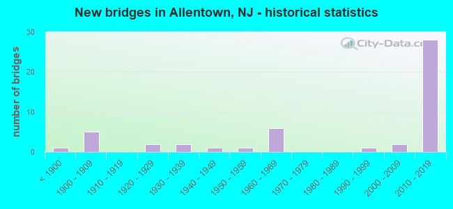
- New bridges - historical statistics
- 1Before 1900
- 51900-1909
- 21920-1929
- 21930-1939
- 11940-1949
- 11950-1959
- 61960-1969
- 11990-1999
- 22000-2009
- 282010-2019
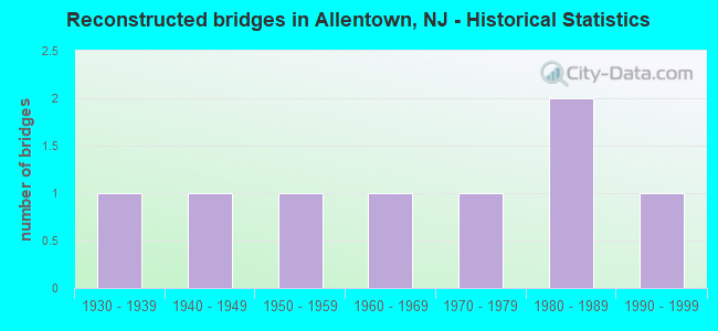
- Reconstructed bridges - Historical Statistics
- 11930-1939
- 11940-1949
- 11950-1959
- 11960-1969
- 11970-1979
- 21980-1989
- 11990-1999
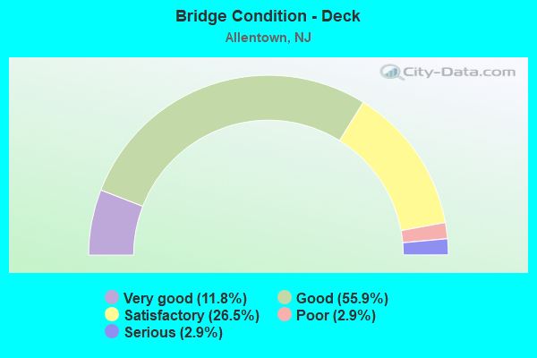
- Bridge Condition - Deck
- 11.8%Very good
- 55.9%Good
- 26.5%Satisfactory
- 2.9%Poor
- 2.9%Serious
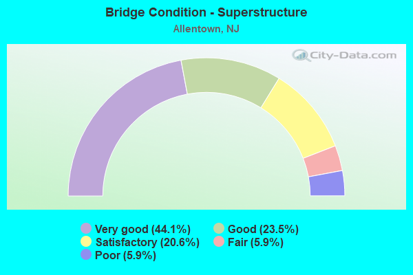
- Bridge Condition - Superstructure
- 44.1%Very good
- 23.5%Good
- 20.6%Satisfactory
- 5.9%Fair
- 5.9%Poor
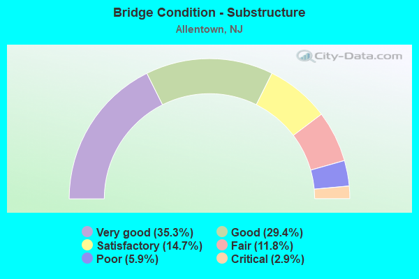
- Bridge Condition - Substructure
- 35.3%Very good
- 29.4%Good
- 14.7%Satisfactory
- 11.8%Fair
- 5.9%Poor
- 2.9%Critical
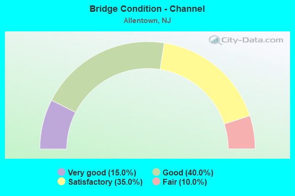
- Bridge Condition - Channel
- 15.0%Very good
- 40.0%Good
- 35.0%Satisfactory
- 10.0%Fair
Find on map >> Show street view
Structure Number: 3F23, Location: 0.4 M. S. of Elisdale Rd. (Lat: 40.137019, Lng: -74.600369), Route carried "on" structure: Other road , Year Built: 1997, Status: Open, Structure Length: 2.71m (8.89ft), Average Daily Traffic: 552 (year 2020), Truck Traffic: 3%, Average Future Daily Traffic: 673 (year 2040), Design Load: HS 20+Mod, Features Intersected: CROSSWICKS CREEK, Facility Carried by Structure: EXTONVILLE ROAD
Minimum Vertical Clearance: 30+ m (98+ ft), Kilometerpoint: 0.000, Lanes on structure: 2, Owner: County Highway Agency, Approaching Roadway Width: 8.8m (28.9ft), Skew: 1 degrees, Material/Design: Prestressed concrete, Design/Construction: Slab, Number Of Spans In Main Unit: 2, Length of Maximum Span: 12.8m (42.0ft), Curb-To-Curb Width: 8.8m (28.9ft), Out-to-Out Width: 10.1m (33.1ft)
Condition: Deck: Good, Superstructure: Good, Substructure: Good, Channel: Satisfactory, Inventory Rating: 54.4 metric tons, Method Used To Determine Inventory Rating: Load Factor (LF), Structural Evaluation: Better than present minimum criteria, Deck Geometry: Somewhat better than minimum adequacy, Waterway Adequacy: Superior to present desirable criteria, Approach Roadway Alignment: Equal to present minimum criteria, Designated Inspection Frequency: Every 24 months, Underwater Inspection Frequency: Every 48 months, Inspection Date: September 2020, Underwater Inspection Date: October 2020, Deck Structure Type: Concrete Cast-file-Place, Wearing Surface/Protective System: Wearing Surface: Monolithic Concrete, Deck Protection: Epoxy Coated Reinforcing
Find on map >> Show street view
Structure Number: 1109402, Location: 0.1 mi North of Sharon Rd (Lat: 40.218300, Lng: -74.560239), Route carried "on" structure: Other road , Year Built: 2011, Status: Open, Structure Length: 1.37m (4.49ft), Average Daily Traffic: 3,793 (year 2021), Truck Traffic: 3%, Average Future Daily Traffic: 4,551 (year 2041), Design Load: HS 25 or greater, Features Intersected: ASSUNPINK CREEK, Facility Carried by Structure: WINDSOR ROAD
Minimum Vertical Clearance: 30+ m (98+ ft), Kilometerpoint: 0.000, Lanes on structure: 2, Owner: County Highway Agency, Approaching Roadway Width: 8.5m (27.9ft), Material/Design: Prestressed concrete, Design/Construction: Slab, Number Of Spans In Main Unit: 1, Length of Maximum Span: 12.2m (40.0ft), Curb or Sidewalk Widths: Left: 1.3m (4.3ft), Right: 0.0m, Curb-To-Curb Width: 8.5m (27.9ft), Out-to-Out Width: 10.9m (35.8ft)
Condition: Deck: Good, Superstructure: Very good, Substructure: Very good, Channel: Good, Inventory Rating: 62.6 metric tons, Method Used To Determine Inventory Rating: Load Factor (LF), Structural Evaluation: Equal to present desirable criteria, Deck Geometry: Meets minimum limits, Waterway Adequacy: Better than present minimum criteria, Approach Roadway Alignment: Better than present minimum criteria, Designated Inspection Frequency: Every 24 months, Inspection Date: Febuary 2021, Deck Structure Type: Concrete Cast-file-Place, Wearing Surface/Protective System: Wearing Surface: Monolithic Concrete, Deck Protection: Epoxy Coated Reinforcing
Find on map >> Show street view
Structure Number: 1109432, Location: 0.5 MI EAST OF NJ TPK (Lat: 40.216589, Lng: -74.560731), Route carried "on" structure: Other road , Year Built: 1949, Status: Open, Structure Length: 1.13m (3.71ft), Average Daily Traffic: 2,428 (year 2021), Truck Traffic: 5%, Average Future Daily Traffic: 2,913 (year 2041), Features Intersected: TRIB. OF ASSUNPINK CRK, Facility Carried by Structure: SHARON ROAD
Minimum Vertical Clearance: 30+ m (98+ ft), Kilometerpoint: 2.849, Lanes on structure: 2, Owner: County Highway Agency, Approaching Roadway Width: 7.3m (24.0ft), Skew: 2 degrees, Material/Design: Steel, Design/Construction: Stringer/Multi-beam, Number Of Spans In Main Unit: 1, Length of Maximum Span: 10.4m (34.1ft), Curb or Sidewalk Widths: Left: 0.2m (0.7ft), Right: 0.2m (0.7ft), Curb-To-Curb Width: 8.6m (28.2ft), Out-to-Out Width: 10.0m (32.8ft)
Condition: Deck: Satisfactory, Superstructure: Satisfactory, Substructure: Fair, Channel: Satisfactory, Inventory Rating: 59.9 metric tons, Method Used To Determine Inventory Rating: Load Factor (LF), Structural Evaluation: Somewhat better than minimum adequacy, Deck Geometry: Meets minimum limits, Waterway Adequacy: Better than present minimum criteria, Approach Roadway Alignment: Equal to present minimum criteria, Designated Inspection Frequency: Every 24 months, Inspection Date: Febuary 2021, Deck Structure Type: Concrete Cast-file-Place, Wearing Surface/Protective System: Wearing Surface: Monolithic Concrete
Find on map >> Show street view
Structure Number: 1300U11, Location: 0.2 MI. SOUTH CR 526 (Lat: 40.164381, Lng: -74.513519), Route carried "on" structure: Other road , Year Built: 1925, Year Reconstructed: 1995, Status: Open, Structure Length: 0.91m (2.99ft), Average Daily Traffic: 1,300 (year 2021), Truck Traffic: 3%, Average Future Daily Traffic: 1,556 (year 2041), Features Intersected: DOCTORS CREEK, Facility Carried by Structure: DAVIS STA-IMLTN.RD
Minimum Vertical Clearance: 30+ m (98+ ft), Kilometerpoint: 0.000, Lanes on structure: 2, Owner: County Highway Agency, Maintenance Responsibility: City or Municipal Highway Agency, Approaching Roadway Width: 7.3m (24.0ft), Material/Design: Prestressed concrete, Design/Construction: Box Beam or Girders - Multiple, Number Of Spans In Main Unit: 1, Length of Maximum Span: 8.2m (26.9ft), Curb or Sidewalk Widths: Left: 1.5m (4.9ft), Right: 1.5m (4.9ft), Curb-To-Curb Width: 7.3m (24.0ft), Out-to-Out Width: 11.0m (36.1ft)
Condition: Deck: Good, Superstructure: Very good, Substructure: Satisfactory, Channel: Good, Operating Rating: 89.8 metric tons, Method Used To Determine Operating Rating: Load Factor (LF), Inventory Rating: 72.6 metric tons, Method Used To Determine Inventory Rating: Load Factor (LF), Structural Evaluation: Equal to present minimum criteria, Deck Geometry: Meets minimum limits, Waterway Adequacy: Superior to present desirable criteria, Approach Roadway Alignment: Equal to present minimum criteria, Designated Inspection Frequency: Every 24 months, Inspection Date: March 2021, Deck Structure Type: Concrete Cast-file-Place, Wearing Surface/Protective System: Wearing Surface: Monolithic Concrete, Deck Protection: Galvanized Reinforcing
Find on map >> Show street view
Structure Number: 1300U12, Location: ALLENTOWN (Lat: 40.175831, Lng: -74.586661), Route carried "on" structure: County highway 524, Year Built: 2011, Status: Open, Structure Length: 1.77m (5.81ft), Average Daily Traffic: 9,241 (year 2021), Truck Traffic: 4%, Average Future Daily Traffic: 11,276 (year 2041), Design Load: HS 25 or greater, Features Intersected: DOCTOR'S CREEK
Minimum Vertical Clearance: 30+ m (98+ ft), Kilometerpoint: 10.654, Lanes on structure: 2, Owner: County Highway Agency, Approaching Roadway Width: 8.5m (27.9ft), Material/Design: Prestressed concrete, Design/Construction: Stringer/Multi-beam, Number Of Spans In Main Unit: 1, Length of Maximum Span: 16.2m (53.1ft), Curb or Sidewalk Widths: Left: 0.0m, Right: 1.6m (5.2ft), Curb-To-Curb Width: 8.5m (27.9ft), Out-to-Out Width: 11.7m (38.4ft)
Condition: Deck: Good, Superstructure: Very good, Substructure: Good, Channel: Good, Operating Rating: 63.5 metric tons, Method Used To Determine Operating Rating: Load Factor (LF), Inventory Rating: 34.5 metric tons, Method Used To Determine Inventory Rating: Load Factor (LF), Structural Evaluation: Better than present minimum criteria, Deck Geometry: High priority of replacement, Waterway Adequacy: Better than present minimum criteria, Approach Roadway Alignment: Somewhat better than minimum adequacy, Designated Inspection Frequency: Every 24 months, Inspection Date: May 2021, Deck Structure Type: Concrete Cast-file-Place, Wearing Surface/Protective System: Wearing Surface: Bituminous, Membrane: Preformed Fabric, Deck Protection: Galvanized Reinforcing
Find on map >> Show street view
Structure Number: 1300U14, Location: 0.95 MI W OF RT 539 (Lat: 40.174661, Lng: -74.606019), Route carried "on" structure: County highway 524, Year Built: 1934, Status: Open, Structure Length: 1.07m (3.51ft), Average Daily Traffic: 5,070 (year 2021), Truck Traffic: 4%, Average Future Daily Traffic: 6,186 (year 2041), Features Intersected: DOCTOR'S CREEK
Minimum Vertical Clearance: 30+ m (98+ ft), Kilometerpoint: 8.964, Lanes on structure: 2, Owner: County Highway Agency, Approaching Roadway Width: 12.2m (40.0ft), Material/Design: Steel, Design/Construction: Stringer/Multi-beam, Number Of Spans In Main Unit: 1, Length of Maximum Span: 9.8m (32.2ft), Curb or Sidewalk Widths: Left: 0.3m (1.0ft), Right: 1.9m (6.2ft), Curb-To-Curb Width: 12.2m (40.0ft), Out-to-Out Width: 15.2m (49.9ft)
Condition: Deck: Satisfactory, Superstructure: Satisfactory, Substructure: Fair, Channel: Good, Operating Rating: 60.8 metric tons, Method Used To Determine Operating Rating: Load Factor (LF), Inventory Rating: 36.3 metric tons, Method Used To Determine Inventory Rating: Load Factor (LF), Structural Evaluation: Somewhat better than minimum adequacy, Deck Geometry: Somewhat better than minimum adequacy, Waterway Adequacy: Superior to present desirable criteria, Approach Roadway Alignment: Better than present minimum criteria, Designated Inspection Frequency: Every 24 months, Underwater Inspection Frequency: Every 48 months, Inspection Date: May 2021, Underwater Inspection Date: June 2019, Deck Structure Type: Concrete Cast-file-Place, Wearing Surface/Protective System: Wearing Surface: Bituminous
Find on map >> Show street view
Structure Number: 1300U15, Location: 0.25 MILE NORTH RT 524 (Lat: 40.176919, Lng: -74.598719), Route carried "on" structure: Other road , Year Built: 1900, Year Reconstructed: 1971, Status: Open, Structure Length: 1.52m (4.99ft), Average Daily Traffic: 538 (year 2021), Truck Traffic: 3%, Average Future Daily Traffic: 643 (year 2041), Features Intersected: DOCTORS CREEK, Facility Carried by Structure: BREZA ROAD
Minimum Vertical Clearance: 30+ m (98+ ft), Kilometerpoint: 0.000, Lanes on structure: 2, Owner: County Highway Agency, Approaching Roadway Width: 6.7m (22.0ft), Material/Design: Concrete continuous, Design/Construction: Slab, Number Of Spans In Main Unit: 3, Length of Maximum Span: 4.9m (16.1ft), Curb or Sidewalk Widths: Left: 0.3m (1.0ft), Right: 0.3m (1.0ft), Curb-To-Curb Width: 6.8m (22.3ft), Out-to-Out Width: 7.4m (24.3ft)
Condition: Deck: Satisfactory, Superstructure: Satisfactory, Substructure: Poor, Channel: Fair, Operating Rating: 74.4 metric tons, Method Used To Determine Operating Rating: Load Factor (LF), Inventory Rating: 44.5 metric tons, Method Used To Determine Inventory Rating: Load Factor (LF), Structural Evaluation: Meets minimum limits, Deck Geometry: Meets minimum limits, Waterway Adequacy: Equal to present minimum criteria, Approach Roadway Alignment: Better than present minimum criteria, Length Of Structure Improvement: 1.52m (4.99ft), Designated Inspection Frequency: Every 24 months, Inspection Date: March 2021, Bridge Improvement Cost: $879,000, Roadway Improvement Cost: $132,000, Total Project Cost: $1,572,000 ( Estimate for 2021), Deck Structure Type: Concrete Cast-file-Place, Wearing Surface/Protective System: Wearing Surface: Monolithic Concrete
Find on map >> Show street view
Structure Number: 1300U16, Location: 0.5 MILE NORTH RT 524 (Lat: 40.180200, Lng: -74.599089), Route carried "on" structure: Other road , Year Built: 1900, Year Reconstructed: 1994, Status: Posted for load, Structure Length: 0.85m (2.79ft), Average Daily Traffic: 528 (year 2021), Truck Traffic: 3%, Average Future Daily Traffic: 633 (year 2041), Features Intersected: INDIAN RUN, Facility Carried by Structure: BREZA ROAD
Minimum Vertical Clearance: 30+ m (98+ ft), Kilometerpoint: 0.000, Lanes on structure: 1, Owner: County Highway Agency, Approaching Roadway Width: 4.9m (16.1ft), Material/Design: Wood or Timber, Design/Construction: Stringer/Multi-beam, Number Of Spans In Main Unit: 2, Length of Maximum Span: 4.0m (13.1ft), Curb or Sidewalk Widths: Left: 0.2m (0.7ft), Right: 0.2m (0.7ft), Curb-To-Curb Width: 4.9m (16.1ft), Out-to-Out Width: 5.3m (17.4ft)
Condition: Deck: Good, Superstructure: Satisfactory, Substructure: Satisfactory, Channel: Satisfactory, Operating Rating: 33.6 metric tons, Method Used To Determine Operating Rating: Allowable Stress (AS), Inventory Rating: 25.4 metric tons, Method Used To Determine Inventory Rating: Allowable Stress (AS), Structural Evaluation: Equal to present minimum criteria, Deck Geometry: High priority of replacement, Waterway Adequacy: Better than present minimum criteria, Approach Roadway Alignment: Equal to present desirable criteria, Length Of Structure Improvement: 0.91m (2.99ft), Designated Inspection Frequency: Every 24 months, Inspection Date: March 2021, Bridge Improvement Cost: $329,000, Roadway Improvement Cost: $140,000, Total Project Cost: $586,000 ( Estimate for 2021), Deck Structure Type: Wood or Timber, Wearing Surface/Protective System: Wearing Surface: Gravel
Find on map >> Show street view
Structure Number: 1300U18, Location: 0.79 MI E OF I-195 (Lat: 40.181300, Lng: -74.589261), Route carried "on" structure: County highway 526, Year Built: 1930, Year Reconstructed: 1976, Status: Open, Structure Length: 0.70m (2.30ft), Average Daily Traffic: 4,094 (year 2021), Truck Traffic: 4%, Average Future Daily Traffic: 4,995 (year 2041), Features Intersected: INDIAN RUN
Minimum Vertical Clearance: 30+ m (98+ ft), Kilometerpoint: 16.319, Lanes on structure: 2, Owner: County Highway Agency, Approaching Roadway Width: 9.1m (29.9ft), Material/Design: Concrete, Design/Construction: Tee Beam, Number Of Spans In Main Unit: 1, Length of Maximum Span: 6.7m (22.0ft), Curb or Sidewalk Widths: Left: 1.5m (4.9ft), Right: 1.5m (4.9ft), Curb-To-Curb Width: 9.3m (30.5ft), Out-to-Out Width: 12.9m (42.3ft)
Condition: Deck: Good, Superstructure: Good, Substructure: Satisfactory, Channel: Satisfactory, Operating Rating: 64.4 metric tons, Method Used To Determine Operating Rating: Load Factor (LF), Inventory Rating: 39.0 metric tons, Method Used To Determine Inventory Rating: Load Factor (LF), Structural Evaluation: Equal to present minimum criteria, Deck Geometry: Meets minimum limits, Waterway Adequacy: Better than present minimum criteria, Approach Roadway Alignment: Better than present minimum criteria, Length Of Structure Improvement: 0.70m (2.30ft), Designated Inspection Frequency: Every 24 months, Inspection Date: May 2021, Bridge Improvement Cost: $62,000, Roadway Improvement Cost: $63,000, Total Project Cost: $185,000 ( Estimate for 2021), Deck Structure Type: Concrete Cast-file-Place, Wearing Surface/Protective System: Wearing Surface: Bituminous
Find on map >> Show street view
Structure Number: 1300U19, Location: 0.1 mi West Forge Mill Ln (Lat: 40.175461, Lng: -74.567711), Route carried "on" structure: County highway 526, Year Built: 2003, Status: Open, Structure Length: 0.98m (3.22ft), Average Daily Traffic: 6,900 (year 2021), Truck Traffic: 12%, Average Future Daily Traffic: 8,275 (year 2041), Features Intersected: NEGRON RUN
Minimum Vertical Clearance: 30+ m (98+ ft), Kilometerpoint: 18.347, Lanes on structure: 2, Owner: County Highway Agency, Approaching Roadway Width: 12.2m (40.0ft), Material/Design: Concrete continuous, Design/Construction: Slab, Number Of Spans In Main Unit: 2, Length of Maximum Span: 4.6m (15.1ft), Curb or Sidewalk Widths: Left: 0.2m (0.7ft), Right: 0.2m (0.7ft), Curb-To-Curb Width: 12.2m (40.0ft), Out-to-Out Width: 13.3m (43.6ft)
Condition: Deck: Satisfactory, Superstructure: Satisfactory, Substructure: Good, Channel: Good, Operating Rating: 67.1 metric tons, Method Used To Determine Operating Rating: Load Factor (LF), Inventory Rating: 39.9 metric tons, Method Used To Determine Inventory Rating: Load Factor (LF), Structural Evaluation: Equal to present minimum criteria, Deck Geometry: Somewhat better than minimum adequacy, Waterway Adequacy: Equal to present minimum criteria, Approach Roadway Alignment: Better than present minimum criteria, Designated Inspection Frequency: Every 24 months, Inspection Date: March 2021, Deck Structure Type: Concrete Cast-file-Place, Wearing Surface/Protective System: Wearing Surface: Monolithic Concrete, Deck Protection: Galvanized Reinforcing
Find on map >> Show street view
Structure Number: 1300U34, Location: 0.5 MI NORTH RT 539 (Lat: 40.157950, Lng: -74.539569), Route carried "on" structure: Other road , Year Built: 1900, Year Reconstructed: 1961, Status: Open, Structure Length: 0.98m (3.22ft), Average Daily Traffic: 6,701 (year 2021), Truck Traffic: 3%, Average Future Daily Traffic: 8,150 (year 2041), Features Intersected: DOCTORS CREEK, Facility Carried by Structure: SHARON STATION RD
Minimum Vertical Clearance: 30+ m (98+ ft), Kilometerpoint: 0.000, Lanes on structure: 2, Owner: County Highway Agency, Approaching Roadway Width: 6.7m (22.0ft), Material/Design: Concrete continuous, Design/Construction: Box Beam or Girders - Multiple, Number Of Spans In Main Unit: 2, Length of Maximum Span: 4.6m (15.1ft), Curb-To-Curb Width: 7.0m (23.0ft), Out-to-Out Width: 7.3m (24.0ft)
Condition: Deck: Poor, Superstructure: Poor, Substructure: Fair, Channel: Satisfactory, Operating Rating: 59.9 metric tons, Method Used To Determine Operating Rating: Load Factor (LF), Inventory Rating: 35.4 metric tons, Method Used To Determine Inventory Rating: Load Factor (LF), Structural Evaluation: Meets minimum limits, Deck Geometry: High priority of replacement, Waterway Adequacy: Somewhat better than minimum adequacy, Approach Roadway Alignment: Equal to present desirable criteria, Length Of Structure Improvement: 1.60m (5.25ft), Designated Inspection Frequency: Every 24 months, Inspection Date: March 2021, Bridge Improvement Cost: $898,000, Roadway Improvement Cost: $135,000, Total Project Cost: $1,609,000 ( Estimate for 2019), Deck Structure Type: Concrete Precast Panels, Wearing Surface/Protective System: Wearing Surface: Bituminous
Find on map >> Show street view
Structure Number: 1300U36, Location: 180' South of I-195 (Lat: 40.176181, Lng: -74.540539), Route carried "on" structure: Other road , Year Built: 2000, Status: Open, Structure Length: 0.67m (2.20ft), Average Daily Traffic: 2,197 (year 2021), Truck Traffic: 3%, Average Future Daily Traffic: 2,670 (year 2041), Features Intersected: NEGRO RUN, Facility Carried by Structure: SHARON STATION RD
Minimum Vertical Clearance: 30+ m (98+ ft), Kilometerpoint: 0.000, Lanes on structure: 2, Owner: County Highway Agency, Approaching Roadway Width: 9.1m (29.9ft), Skew: 1 degrees, Material/Design: Prestressed concrete, Design/Construction: Box Beam or Girders - Multiple, Number Of Spans In Main Unit: 1, Length of Maximum Span: 6.4m (21.0ft), Curb or Sidewalk Widths: Left: 1.5m (4.9ft), Right: 0.2m (0.7ft), Curb-To-Curb Width: 9.1m (29.9ft), Out-to-Out Width: 11.6m (38.1ft)
Condition: Deck: Satisfactory, Superstructure: Very good, Substructure: Good, Channel: Good, Inventory Rating: 82.6 metric tons, Method Used To Determine Inventory Rating: Load Factor (LF), Structural Evaluation: Better than present minimum criteria, Deck Geometry: Meets minimum limits, Waterway Adequacy: Equal to present desirable criteria, Approach Roadway Alignment: Equal to present desirable criteria, Designated Inspection Frequency: Every 24 months, Inspection Date: March 2021, Deck Structure Type: Concrete Precast Panels, Wearing Surface/Protective System: Deck Protection: Galvanized Reinforcing
Find on map >> Show street view
Structure Number: 1300U47, Location: 5 MI NW RT 539 & RT 537 (Lat: 40.133261, Lng: -74.560150), Route carried "on" structure: Other road , Year Built: 1900, Year Reconstructed: 1948, Status: Posted for load, Structure Length: 1.89m (6.20ft), Average Daily Traffic: 275 (year 2021), Truck Traffic: 3%, Average Future Daily Traffic: 330 (year 2041), Features Intersected: CROSSWICKS CREEK, Facility Carried by Structure: WALNS MILL ROAD
Minimum Vertical Clearance: 30+ m (98+ ft), Kilometerpoint: 0.000, Lanes on structure: 1, Owner: County Highway Agency, Approaching Roadway Width: 4.6m (15.1ft), Material/Design: Wood or Timber, Design/Construction: Stringer/Multi-beam, Number Of Spans In Main Unit: 4, Length of Maximum Span: 5.2m (17.1ft), Curb-To-Curb Width: 4.5m (14.8ft), Out-to-Out Width: 4.6m (15.1ft)
Condition: Deck: Satisfactory, Superstructure: Satisfactory, Substructure: Critical, Channel: Fair, Operating Rating: 34.5 metric tons, Method Used To Determine Operating Rating: Allowable Stress (AS), Inventory Rating: 25.4 metric tons, Method Used To Determine Inventory Rating: Allowable Stress (AS), Structural Evaluation: High priority of replacement, Deck Geometry: High priority of replacement, Waterway Adequacy: Equal to present desirable criteria, Approach Roadway Alignment: Somewhat better than minimum adequacy, Length Of Structure Improvement: 2.59m (8.50ft), Designated Inspection Frequency: Every 24 months, Critical Feature Inspection Frequency: Every 24 months, Underwater Inspection Frequency: Every 48 months, Other Special Inspection Frequency: Every 12 months, Inspection Date: March 2021, Critical Feature Inspection Date: March 2021, Underwater Inspection Date: April 2021, Other Special Inspection Date: March 2021, Bridge Improvement Cost: $1,493,000, Roadway Improvement Cost: $224,000, Total Project Cost: $2,563,000 ( Estimate for 2021), Deck Structure Type: Wood or Timber, Wearing Surface/Protective System: Wearing Surface: Bituminous
Find on map >> Show street view
Structure Number: 1300U48, Location: 5 MI NW RT 539 & RT 537 (Lat: 40.134100, Lng: -74.560050), Route carried "on" structure: Other road , Year Built: 1900, Year Reconstructed: 1943, Status: Posted for load, Structure Length: 2.29m (7.51ft), Average Daily Traffic: 275 (year 2021), Average Future Daily Traffic: 330 (year 2041), Features Intersected: CROSSWICKS CREEK, Facility Carried by Structure: WALNS MILL ROAD
Minimum Vertical Clearance: 30+ m (98+ ft), Kilometerpoint: 0.000, Lanes on structure: 1, Owner: County Highway Agency, Approaching Roadway Width: 6.7m (22.0ft), Material/Design: Wood or Timber, Design/Construction: Stringer/Multi-beam, Number Of Spans In Main Unit: 8, Length of Maximum Span: 2.7m (8.9ft), Curb-To-Curb Width: 5.2m (17.1ft), Out-to-Out Width: 5.5m (18.0ft)
Condition: Deck: Serious, Superstructure: Poor, Substructure: Fair, Channel: Good, Operating Rating: 4.5 metric tons, Method Used To Determine Operating Rating: Allowable Stress (AS), Inventory Rating: 2.7 metric tons, Method Used To Determine Inventory Rating: Allowable Stress (AS), Structural Evaluation: High priority of replacement, Deck Geometry: High priority of replacement, Waterway Adequacy: Equal to present minimum criteria, Approach Roadway Alignment: Somewhat better than minimum adequacy, Bridge Posting: Required (Relationship of Operating Rating to Maximum Legal Load: > 39.9% below), Length Of Structure Improvement: 2.99m (9.81ft), Designated Inspection Frequency: Every 24 months, Critical Feature Inspection Frequency: Every 24 months, Other Special Inspection Frequency: Every 12 months, Inspection Date: March 2021, Critical Feature Inspection Date: March 2021, Other Special Inspection Date: March 2021, Bridge Improvement Cost: $1,753,000, Roadway Improvement Cost: $263,000, Total Project Cost: $3,010,000 ( Estimate for 2021), Deck Structure Type: Wood or Timber, Wearing Surface/Protective System: Wearing Surface: Bituminous
Find on map >> Show street view
Structure Number: 1300U53, Location: 3 MI N OF CR 664/27 (Lat: 40.139119, Lng: -74.587419), Route carried "on" structure: Other road , Year Built: 1891, Year Reconstructed: 1994, Status: Posted for load, Structure Length: 3.38m (11.09ft), Average Daily Traffic: 1,635 (year 2021), Truck Traffic: 3%, Average Future Daily Traffic: 1,950 (year 2041), Features Intersected: CROSSWICKS CREEK, Facility Carried by Structure: PROVINCE LINE ROAD
Minimum Vertical Clearance: 4.15m (13.62ft), Kilometerpoint: 0.000, Lanes on structure: 1, Owner: County Highway Agency, Approaching Roadway Width: 6.1m (20.0ft), Material/Design: Steel continuous, Design/Construction: Girder and Floorbeam System, Number Of Spans In Main Unit: 6, Length of Maximum Span: 7.3m (24.0ft), Curb-To-Curb Width: 4.8m (15.7ft), Out-to-Out Width: 5.0m (16.4ft)
Condition: Deck: Satisfactory, Superstructure: Good, Substructure: Satisfactory, Channel: Satisfactory, Operating Rating: 31.8 metric tons, Method Used To Determine Operating Rating: Load Factor (LF), Inventory Rating: 19.1 metric tons, Method Used To Determine Inventory Rating: Load Factor (LF), Structural Evaluation: Somewhat better than minimum adequacy, Deck Geometry: High priority of replacement, Waterway Adequacy: Better than present minimum criteria, Approach Roadway Alignment: Equal to present minimum criteria, Length Of Structure Improvement: 4.33m (14.21ft), Designated Inspection Frequency: Every 24 months, Critical Feature Inspection Frequency: Every 24 months, Underwater Inspection Frequency: Every 48 months, Inspection Date: March 2021, Critical Feature Inspection Date: March 2021, Underwater Inspection Date: April 2019, Bridge Improvement Cost: $2,496,000, Roadway Improvement Cost: $374,000, Total Project Cost: $4,103,000 ( Estimate for 2021), Deck Structure Type: Corrugated Steel, Wearing Surface/Protective System: Wearing Surface: Bituminous, Membrane: Built-up
Find on map >> Show street view
Structure Number: 1300U71, Location: 5 MI. S. OF HIGHTSTOWN (Lat: 40.206881, Lng: -74.549419), Route carried "on" structure: County highway 539, Year Built: 1925, Status: Posted for load, Structure Length: 0.85m (2.79ft), Average Daily Traffic: 5,378 (year 2021), Truck Traffic: 3%, Average Future Daily Traffic: 6,562 (year 2041), Features Intersected: NEW SHARON BROOK
Minimum Vertical Clearance: 30+ m (98+ ft), Kilometerpoint: 75.977, Lanes on structure: 2, Owner: County Highway Agency, Approaching Roadway Width: 7.6m (24.9ft), Material/Design: Steel, Design/Construction: Stringer/Multi-beam, Number Of Spans In Main Unit: 1, Length of Maximum Span: 7.9m (25.9ft), Curb-To-Curb Width: 9.2m (30.2ft), Out-to-Out Width: 9.8m (32.2ft)
Condition: Deck: Satisfactory, Superstructure: Fair, Substructure: Poor, Channel: Good, Operating Rating: 25.4 metric tons, Method Used To Determine Operating Rating: Load Factor (LF), Inventory Rating: 15.4 metric tons, Method Used To Determine Inventory Rating: Load Factor (LF), Structural Evaluation: High priority of replacement, Deck Geometry: High priority of corrective action, Waterway Adequacy: Equal to present minimum criteria, Approach Roadway Alignment: Somewhat better than minimum adequacy, Bridge Posting: Required (Relationship of Operating Rating to Maximum Legal Load: 0.1 - 9.9% below), Length Of Structure Improvement: 1.46m (4.79ft), Designated Inspection Frequency: Every 24 months, Underwater Inspection Frequency: Every 24 months, Other Special Inspection Frequency: Every 12 months, Inspection Date: May 2021, Underwater Inspection Date: June 2021, Other Special Inspection Date: May 2021, Bridge Improvement Cost: $801,000, Roadway Improvement Cost: $74,000, Total Project Cost: $1,238,000 ( Estimate for 2021), Deck Structure Type: Concrete Cast-file-Place, Wearing Surface/Protective System: Wearing Surface: Bituminous
Find on map >> Show street view
Structure Number: 133015, Location: 1.7 MI EAST OF NJ TPK JCT (Lat: 40.185600, Lng: -74.570439), Route carried "on" structure: County highway 524, Year Built: 1969, Status: Open, Structure Length: 6.40m (21.00ft), Average Daily Traffic: 5,443 (year 2020), Truck Traffic: 3%, Average Future Daily Traffic: 6,531 (year 2040), Design Load: HS 20, Features Intersected: I-195, Facility Carried by Structure: OLD YORK ROAD
Minimum Vertical Clearance: 30+ m (98+ ft), Kilometerpoint: 12.456, Lanes on structure: 2, Lanes under structure: 6, Owner: State Highway Agency, Approaching Roadway Width: 15.2m (49.9ft), Skew: 3 degrees, Material/Design: Steel, Design/Construction: Stringer/Multi-beam, Number Of Spans In Main Unit: 2, Length of Maximum Span: 31.4m (103.0ft), Curb or Sidewalk Widths: Left: 1.8m (5.9ft), Right: 1.8m (5.9ft), Curb-To-Curb Width: 15.2m (49.9ft), Out-to-Out Width: 19.5m (64.0ft)
Condition: Deck: Satisfactory, Superstructure: Good, Substructure: Good, Operating Rating: 71.7 metric tons, Method Used To Determine Operating Rating: Load Factor (LF), Inventory Rating: 42.6 metric tons, Method Used To Determine Inventory Rating: Load Factor (LF), Structural Evaluation: Better than present minimum criteria, Deck Geometry: Superior to present desirable criteria, Underclear: High priority of corrective action, Approach Roadway Alignment: Better than present minimum criteria, Length Of Structure Improvement: 30.48m (100.00ft), Designated Inspection Frequency: Every 24 months, Inspection Date: April 2020, Roadway Improvement Cost: $226,000, Total Project Cost: $249,000 ( Estimate for 2020), Deck Structure Type: Concrete Cast-file-Place, Wearing Surface/Protective System: Wearing Surface: Latex Concrete
Find on map >> Show street view
Structure Number: 1330151, Location: 1.6MI EAST OF CO.RT 539 (Lat: 40.176789, Lng: -74.540639), Route carried "on" structure: Interstate 195, Year Built: 1969, Status: Open, Structure Length: 2.71m (8.89ft), Average Daily Traffic: 26,302 (year 2020), Truck Traffic: 14%, Average Future Daily Traffic: 31,562 (year 2040), Design Load: HS 20, Features Intersected: SHARON STATION ROAD
Minimum Vertical Clearance: 30+ m (98+ ft), Kilometerpoint: 16.496, Lanes on structure: 2, Lanes under structure: 2, Base Highway Network: Yes, Owner: State Highway Agency, Approaching Roadway Width: 11.9m (39.0ft), Material/Design: Steel, Design/Construction: Stringer/Multi-beam, Number Of Spans In Main Unit: 1, Length of Maximum Span: 25.9m (85.0ft), Curb or Sidewalk Widths: Left: 0.5m (1.6ft), Right: 0.5m (1.6ft), Curb-To-Curb Width: 11.9m (39.0ft), Out-to-Out Width: 13.6m (44.6ft)
Condition: Deck: Good, Superstructure: Good, Substructure: Satisfactory, Inventory Rating: 56.2 metric tons, Method Used To Determine Inventory Rating: Load Factor (LF), Structural Evaluation: Equal to present minimum criteria, Deck Geometry: Equal to present minimum criteria, Underclear: Better than present minimum criteria, Approach Roadway Alignment: Equal to present desirable criteria, Designated Inspection Frequency: Every 24 months, Inspection Date: May 2020, Deck Structure Type: Concrete Cast-file-Place, Wearing Surface/Protective System: Wearing Surface: Monolithic Concrete
Find on map >> Show street view
Structure Number: 1330152, Location: 1.5 MI W OF I-195 EXIT 11 (Lat: 40.177111, Lng: -74.540289), Route carried "on" structure: Interstate 195, Year Built: 1969, Status: Open, Structure Length: 2.71m (8.89ft), Average Daily Traffic: 27,279 (year 2020), Truck Traffic: 14%, Average Future Daily Traffic: 37,645 (year 2040), Design Load: HS 20, Features Intersected: SHARON STATION ROAD
Minimum Vertical Clearance: 30+ m (98+ ft), Kilometerpoint: 16.496, Lanes on structure: 2, Lanes under structure: 2, Base Highway Network: Yes, Owner: State Highway Agency, Approaching Roadway Width: 11.9m (39.0ft), Material/Design: Steel, Design/Construction: Stringer/Multi-beam, Number Of Spans In Main Unit: 1, Length of Maximum Span: 25.9m (85.0ft), Curb-To-Curb Width: 11.9m (39.0ft), Out-to-Out Width: 13.6m (44.6ft)
Condition: Deck: Good, Superstructure: Good, Substructure: Good, Inventory Rating: 60.8 metric tons, Method Used To Determine Inventory Rating: Load Factor (LF), Structural Evaluation: Better than present minimum criteria, Deck Geometry: Equal to present minimum criteria, Underclear: Equal to present minimum criteria, Approach Roadway Alignment: Equal to present desirable criteria, Designated Inspection Frequency: Every 24 months, Inspection Date: May 2020, Deck Structure Type: Concrete Cast-file-Place, Wearing Surface/Protective System: Wearing Surface: Bituminous, Membrane: Epoxy
Find on map >> Show street view
Structure Number: M05692N, Location: 3 MI NORTH INT 7A (Lat: 40.192358, Lng: -74.601608), Route carried "on" structure: Other road 95, Year Built: 2013, Status: Open, Structure Length: 6.25m (20.51ft), Average Daily Traffic: 27,294 (year 2020), Truck Traffic: 14%, Average Future Daily Traffic: 33,914 (year 2040), Design Load: HL 93, Features Intersected: Crosswicks Cr & U-Turn
Minimum Vertical Clearance: 30+ m (98+ ft), Kilometerpoint: 18.652, Lanes on structure: 3, Lanes under structure: 2, Base Highway Network: Yes, Toll: On toll road, Owner: State Toll Authority, Approaching Roadway Width: 16.8m (55.1ft), Material/Design: Steel continuous, Design/Construction: Stringer/Multi-beam, Number Of Spans In Main Unit: 2, Length of Maximum Span: 36.3m (119.1ft), Curb-To-Curb Width: 16.9m (55.4ft), Out-to-Out Width: 18.0m (59.1ft)
Condition: Deck: Very good, Superstructure: Very good, Substructure: Very good, Channel: Satisfactory, Operating Rating: 54.4 metric tons, Method Used To Determine Operating Rating: Load and Resistance Factor Rating (LRFR) rating reported by rating factor(RF) method using HL-93 loadings, Inventory Rating: 41.8 metric tons, Method Used To Determine Inventory Rating: Load and Resistance Factor Rating (LRFR) rating reported by rating factor(RF) method using HL-93 loadings, Structural Evaluation: Equal to present desirable criteria, Deck Geometry: Equal to present minimum criteria, Underclear: High priority of corrective action, Waterway Adequacy: Superior to present desirable criteria, Approach Roadway Alignment: Equal to present desirable criteria, Designated Inspection Frequency: Every 24 months, Inspection Date: June 2020, Deck Structure Type: Concrete Cast-file-Place, Wearing Surface/Protective System: Wearing Surface: Monolithic Concrete, Deck Protection: Epoxy Coated Reinforcing
Find on map >> Show street view
Structure Number: M06051D, Location: AT INTERCHANGE 7A (Lat: 40.192844, Lng: -74.586522), Route carried "on" structure: Ramp Other road 95, Year Built: 2014, Status: Open, Structure Length: 14.17m (46.49ft), Average Daily Traffic: 1,102 (year 2020), Truck Traffic: 10%, Average Future Daily Traffic: 1,344 (year 2040), Design Load: HL 93, Features Intersected: NJTPK (I-95), Facility Carried by Structure: Ramp TN
Minimum Vertical Clearance: 30+ m (98+ ft), Kilometerpoint: 24.430, Lanes on structure: 2, Lanes under structure: 14, Toll: On toll road, Owner: State Toll Authority, Approaching Roadway Width: 12.2m (40.0ft), Skew: 2 degrees, Material/Design: Steel continuous, Design/Construction: Stringer/Multi-beam, Number Of Spans In Main Unit: 3, Length of Maximum Span: 53.3m (174.9ft), Curb-To-Curb Width: 12.3m (40.4ft), Out-to-Out Width: 13.4m (44.0ft)
Condition: Deck: Very good, Superstructure: Very good, Substructure: Very good, Operating Rating: 49.9 metric tons, Method Used To Determine Operating Rating: Load and Resistance Factor Rating (LRFR) rating reported by rating factor(RF) method using HL-93 loadings, Inventory Rating: 38.6 metric tons, Method Used To Determine Inventory Rating: Load and Resistance Factor Rating (LRFR) rating reported by rating factor(RF) method using HL-93 loadings, Structural Evaluation: Equal to present desirable criteria, Deck Geometry: Superior to present desirable criteria, Underclear: Somewhat better than minimum adequacy, Approach Roadway Alignment: Equal to present desirable criteria, Designated Inspection Frequency: Every 24 months, Inspection Date: June 2020, Deck Structure Type: Concrete Cast-file-Place, Wearing Surface/Protective System: Wearing Surface: Monolithic Concrete, Deck Protection: Epoxy Coated Reinforcing
Find on map >> Show street view
Structure Number: M06051G, Location: At Interchange 7A (Lat: 40.192578, Lng: -74.597156), Route carried "on" structure: Ramp Other road 95, Year Built: 2012, Status: Open, Structure Length: 6.77m (22.21ft), Average Daily Traffic: 4,406 (year 2020), Truck Traffic: 9%, Average Future Daily Traffic: 5,376 (year 2040), Design Load: HL 93, Features Intersected: I-195, Facility Carried by Structure: Ramp TN
Minimum Vertical Clearance: 30+ m (98+ ft), Kilometerpoint: 24.607, Lanes on structure: 2, Lanes under structure: 6, Toll: On toll road, Owner: State Toll Authority, Approaching Roadway Width: 11.9m (39.0ft), Skew: 3 degrees, Material/Design: Steel continuous, Design/Construction: Stringer/Multi-beam, Number Of Spans In Main Unit: 2, Length of Maximum Span: 33.5m (109.9ft), Curb-To-Curb Width: 12.3m (40.4ft), Out-to-Out Width: 13.4m (44.0ft)
Condition: Deck: Good, Superstructure: Good, Substructure: Very good, Operating Rating: 46.0 metric tons, Method Used To Determine Operating Rating: Load and Resistance Factor Rating (LRFR) rating reported by rating factor(RF) method using HL-93 loadings, Inventory Rating: 35.3 metric tons, Method Used To Determine Inventory Rating: Load and Resistance Factor Rating (LRFR) rating reported by rating factor(RF) method using HL-93 loadings, Structural Evaluation: Better than present minimum criteria, Deck Geometry: Superior to present desirable criteria, Underclear: Somewhat better than minimum adequacy, Approach Roadway Alignment: Equal to present desirable criteria, Designated Inspection Frequency: Every 24 months, Inspection Date: June 2020, Deck Structure Type: Concrete Cast-file-Place, Wearing Surface/Protective System: Wearing Surface: Monolithic Concrete, Deck Protection: Epoxy Coated Reinforcing
Find on map >> Show street view
Structure Number: M06051H, Location: At Interchange 7A (Lat: 40.195503, Lng: -74.595811), Route carried "on" structure: County highway 526, Year Built: 2012, Status: Open, Structure Length: 4.05m (13.29ft), Average Daily Traffic: 8,294 (year 2020), Truck Traffic: 4%, Average Future Daily Traffic: 10,120 (year 2040), Design Load: HL 93, Features Intersected: NJ TPK Ramp TN, Facility Carried by Structure: R'ville-A'town Rd
Minimum Vertical Clearance: 30+ m (98+ ft), Kilometerpoint: 14.388, Lanes on structure: 2, Lanes under structure: 2, Owner: State Toll Authority, Approaching Roadway Width: 14.6m (47.9ft), Skew: 3 degrees, Material/Design: Steel, Design/Construction: Stringer/Multi-beam, Number Of Spans In Main Unit: 1, Length of Maximum Span: 39.6m (129.9ft), Curb or Sidewalk Widths: Left: 1.8m (5.9ft), Right: 1.8m (5.9ft), Curb-To-Curb Width: 14.6m (47.9ft), Out-to-Out Width: 19.2m (63.0ft)
Condition: Deck: Good, Superstructure: Very good, Substructure: Good, Operating Rating: 78.4 metric tons, Method Used To Determine Operating Rating: Load and Resistance Factor Rating (LRFR) rating reported by rating factor(RF) method using HL-93 loadings, Inventory Rating: 60.3 metric tons, Method Used To Determine Inventory Rating: Load and Resistance Factor Rating (LRFR) rating reported by rating factor(RF) method using HL-93 loadings, Structural Evaluation: Better than present minimum criteria, Deck Geometry: Superior to present desirable criteria, Underclear: Somewhat better than minimum adequacy, Approach Roadway Alignment: Equal to present desirable criteria, Designated Inspection Frequency: Every 24 months, Inspection Date: June 2020, Deck Structure Type: Concrete Cast-file-Place, Wearing Surface/Protective System: Wearing Surface: Monolithic Concrete, Deck Protection: Epoxy Coated Reinforcing
Find on map >> Show street view
Structure Number: M06051I, Location: At Interchange 7A (Lat: 40.196783, Lng: -74.595406), Route carried "on" structure: Ramp Interstate 95, Year Built: 2012, Status: Open, Structure Length: 9.20m (30.18ft), Average Daily Traffic: 4,405 (year 2020), Truck Traffic: 5%, Average Future Daily Traffic: 5,375 (year 2040), Design Load: HL 93, Features Intersected: NJTPK SNO, Facility Carried by Structure: Ramp TNI
Minimum Vertical Clearance: 30+ m (98+ ft), Kilometerpoint: 25.267, Lanes on structure: 1, Lanes under structure: 3, Toll: On toll road, Owner: State Toll Authority, Approaching Roadway Width: 9.1m (29.9ft), Material/Design: Steel continuous, Design/Construction: Stringer/Multi-beam, Number Of Spans In Main Unit: 2, Length of Maximum Span: 45.7m (149.9ft), Curb-To-Curb Width: 9.2m (30.2ft), Out-to-Out Width: 9.8m (32.2ft)
Condition: Deck: Good, Superstructure: Very good, Substructure: Very good, Operating Rating: 47.3 metric tons, Method Used To Determine Operating Rating: Load and Resistance Factor Rating (LRFR) rating reported by rating factor(RF) method using HL-93 loadings, Inventory Rating: 36.6 metric tons, Method Used To Determine Inventory Rating: Load and Resistance Factor Rating (LRFR) rating reported by rating factor(RF) method using HL-93 loadings, Structural Evaluation: Equal to present desirable criteria, Deck Geometry: Superior to present desirable criteria, Underclear: High priority of corrective action, Approach Roadway Alignment: Equal to present desirable criteria, Designated Inspection Frequency: Every 24 months, Critical Feature Inspection Frequency: Every 24 months, Inspection Date: June 2020, Critical Feature Inspection Date: June 2020, Deck Structure Type: Concrete Cast-file-Place, Wearing Surface/Protective System: Wearing Surface: Monolithic Concrete, Deck Protection: Epoxy Coated Reinforcing
Find on map >> Show street view
Structure Number: M06051J, Location: At Intersection 7A (Lat: 40.198397, Lng: -74.594397), Route carried "on" structure: Ramp Interstate 95, Year Built: 2012, Status: Open, Structure Length: 12.62m (41.40ft), Average Daily Traffic: 3,961 (year 2020), Truck Traffic: 1%, Average Future Daily Traffic: 4,833 (year 2040), Design Load: HL 93, Features Intersected: NJTPK NSO Roadway, Facility Carried by Structure: Ramp NIT
Minimum Vertical Clearance: 30+ m (98+ ft), Kilometerpoint: 24.430, Lanes on structure: 1, Lanes under structure: 3, Toll: On toll road, Owner: State Toll Authority, Approaching Roadway Width: 8.5m (27.9ft), Material/Design: Steel continuous, Design/Construction: Stringer/Multi-beam, Number Of Spans In Main Unit: 3, Length of Maximum Span: 42.1m (138.1ft), Curb-To-Curb Width: 8.6m (28.2ft), Out-to-Out Width: 9.8m (32.2ft)
Condition: Deck: Good, Superstructure: Satisfactory, Substructure: Very good, Operating Rating: 43.7 metric tons, Method Used To Determine Operating Rating: Load and Resistance Factor Rating (LRFR) rating reported by rating factor(RF) method using HL-93 loadings, Inventory Rating: 33.7 metric tons, Method Used To Determine Inventory Rating: Load and Resistance Factor Rating (LRFR) rating reported by rating factor(RF) method using HL-93 loadings, Structural Evaluation: Equal to present minimum criteria, Deck Geometry: Superior to present desirable criteria, Underclear: Equal to present minimum criteria, Approach Roadway Alignment: Equal to present desirable criteria, Designated Inspection Frequency: Every 24 months, Critical Feature Inspection Frequency: Every 24 months, Inspection Date: June 2020, Critical Feature Inspection Date: June 2020, Deck Structure Type: Concrete Cast-file-Place, Wearing Surface/Protective System: Wearing Surface: Monolithic Concrete, Deck Protection: Epoxy Coated Reinforcing
Find on map >> Show street view
Structure Number: M06091R, Location: 0.39 MI North of Int 7A (Lat: 40.196331, Lng: -74.596906), Route carried "on" structure: County highway 526, Year Built: 2012, Status: Open, Structure Length: 14.26m (46.78ft), Average Daily Traffic: 8,294 (year 2020), Truck Traffic: 4%, Average Future Daily Traffic: 10,120 (year 2040), Design Load: HL 93, Features Intersected: NJ TPK, Facility Carried by Structure: R'ville-A'town Rd
Minimum Vertical Clearance: 30+ m (98+ ft), Kilometerpoint: 14.388, Lanes on structure: 2, Lanes under structure: 14, Owner: State Toll Authority, Approaching Roadway Width: 12.2m (40.0ft), Material/Design: Steel continuous, Design/Construction: Stringer/Multi-beam, Number Of Spans In Main Unit: 4, Length of Maximum Span: 47.2m (154.9ft), Curb or Sidewalk Widths: Left: 1.8m (5.9ft), Right: 1.8m (5.9ft), Curb-To-Curb Width: 12.2m (40.0ft), Out-to-Out Width: 16.5m (54.1ft)
Condition: Deck: Good, Superstructure: Very good, Substructure: Good, Operating Rating: 62.5 metric tons, Method Used To Determine Operating Rating: Load and Resistance Factor Rating (LRFR) rating reported by rating factor(RF) method using HL-93 loadings, Inventory Rating: 48.3 metric tons, Method Used To Determine Inventory Rating: Load and Resistance Factor Rating (LRFR) rating reported by rating factor(RF) method using HL-93 loadings, Structural Evaluation: Better than present minimum criteria, Deck Geometry: Somewhat better than minimum adequacy, Underclear: Meets minimum limits, Approach Roadway Alignment: Equal to present desirable criteria, Designated Inspection Frequency: Every 24 months, Inspection Date: July 2020, Deck Structure Type: Concrete Cast-file-Place, Wearing Surface/Protective System: Wearing Surface: Monolithic Concrete, Deck Protection: Epoxy Coated Reinforcing
Find on map >> Show street view
Structure Number: M06187R, Location: 1.3 MI NORTH OF EXIT 7A (Lat: 40.205625, Lng: -74.583422), Route carried "on" structure: City street , Year Built: 2013, Status: Open, Structure Length: 13.62m (44.69ft), Average Daily Traffic: 2,472 (year 2020), Truck Traffic: 1%, Average Future Daily Traffic: 3,017 (year 2040), Design Load: HL 93, Features Intersected: NJTPK(I-95), Facility Carried by Structure: WEST MANOR WAY
Minimum Vertical Clearance: 30+ m (98+ ft), Kilometerpoint: 0.000, Lanes on structure: 2, Lanes under structure: 12, Owner: State Toll Authority, Approaching Roadway Width: 9.1m (29.9ft), Skew: 4 degrees, Material/Design: Steel continuous, Design/Construction: Stringer/Multi-beam, Number Of Spans In Main Unit: 4, Length of Maximum Span: 37.8m (124.0ft), Curb-To-Curb Width: 9.1m (29.9ft), Out-to-Out Width: 10.2m (33.5ft)
Condition: Deck: Good, Superstructure: Very good, Substructure: Good, Operating Rating: 60.9 metric tons, Method Used To Determine Operating Rating: Load and Resistance Factor Rating (LRFR) rating reported by rating factor(RF) method using HL-93 loadings, Inventory Rating: 47.0 metric tons, Method Used To Determine Inventory Rating: Load and Resistance Factor Rating (LRFR) rating reported by rating factor(RF) method using HL-93 loadings, Structural Evaluation: Better than present minimum criteria, Deck Geometry: Meets minimum limits, Underclear: Meets minimum limits, Approach Roadway Alignment: Equal to present desirable criteria, Length Of Structure Improvement: 13.62m (44.69ft), Designated Inspection Frequency: Every 24 months, Inspection Date: July 2020, Bridge Improvement Cost: $2,965,000, Roadway Improvement Cost: $296,000, Total Project Cost: $3,261,000 ( Estimate for 2018), Deck Structure Type: Concrete Cast-file-Place, Wearing Surface/Protective System: Wearing Surface: Monolithic Concrete, Deck Protection: Epoxy Coated Reinforcing
Find on map >> Show street view
Structure Number: M06224R, Location: 2.24 MI North of Exit 7A (Lat: 40.209494, Lng: -74.578783), Route carried "on" structure: City street , Year Built: 2012, Status: Open, Structure Length: 9.94m (32.61ft), Average Daily Traffic: 2,523 (year 2020), Truck Traffic: 1%, Average Future Daily Traffic: 3,079 (year 2040), Design Load: HL 93, Features Intersected: NJTPK, Facility Carried by Structure: Gordon Rd
Minimum Vertical Clearance: 30+ m (98+ ft), Kilometerpoint: 0.000, Lanes on structure: 2, Lanes under structure: 12, Owner: State Toll Authority, Approaching Roadway Width: 9.1m (29.9ft), Material/Design: Steel continuous, Design/Construction: Stringer/Multi-beam, Number Of Spans In Main Unit: 3, Length of Maximum Span: 39.9m (130.9ft), Curb-To-Curb Width: 9.1m (29.9ft), Out-to-Out Width: 10.2m (33.5ft)
Condition: Deck: Good, Superstructure: Very good, Substructure: Very good, Operating Rating: 50.9 metric tons, Method Used To Determine Operating Rating: Load and Resistance Factor Rating (LRFR) rating reported by rating factor(RF) method using HL-93 loadings, Inventory Rating: 39.2 metric tons, Method Used To Determine Inventory Rating: Load and Resistance Factor Rating (LRFR) rating reported by rating factor(RF) method using HL-93 loadings, Structural Evaluation: Equal to present desirable criteria, Deck Geometry: Meets minimum limits, Underclear: Meets minimum limits, Approach Roadway Alignment: Equal to present desirable criteria, Designated Inspection Frequency: Every 24 months, Inspection Date: July 2020, Deck Structure Type: Concrete Cast-file-Place, Wearing Surface/Protective System: Wearing Surface: Monolithic Concrete, Deck Protection: Epoxy Coated Reinforcing
Find on map >> Show street view
Structure Number: M06277, Location: 2.2 mi. North of Int. 7A (Lat: 40.214331, Lng: -74.570578), Route carried "on" structure: Ramp Interstate 95, Year Built: 2012, Status: Open, Structure Length: 9.69m (31.79ft), Average Daily Traffic: 109 (year 2020), Truck Traffic: 1%, Average Future Daily Traffic: 133 (year 2040), Design Load: HL 93, Features Intersected: Turnpike Mainline, Facility Carried by Structure: Mile 63 U-Turn
Minimum Vertical Clearance: 30+ m (98+ ft), Kilometerpoint: 27.970, Lanes on structure: 2, Lanes under structure: 12, Toll: On toll road, Owner: State Toll Authority, Approaching Roadway Width: 7.9m (25.9ft), Material/Design: Steel continuous, Design/Construction: Stringer/Multi-beam, Number Of Spans In Main Unit: 3, Length of Maximum Span: 39.9m (130.9ft), Curb-To-Curb Width: 8.0m (26.2ft), Out-to-Out Width: 9.1m (29.9ft)
Condition: Deck: Good, Superstructure: Very good, Substructure: Very good, Operating Rating: 61.9 metric tons, Method Used To Determine Operating Rating: Load and Resistance Factor Rating (LRFR) rating reported by rating factor(RF) method using HL-93 loadings, Inventory Rating: 47.6 metric tons, Method Used To Determine Inventory Rating: Load and Resistance Factor Rating (LRFR) rating reported by rating factor(RF) method using HL-93 loadings, Structural Evaluation: Equal to present desirable criteria, Deck Geometry: High priority of corrective action, Underclear: Meets minimum limits, Approach Roadway Alignment: Equal to present desirable criteria, Designated Inspection Frequency: Every 24 months, Inspection Date: January 2020, Deck Structure Type: Concrete Cast-file-Place, Wearing Surface/Protective System: Wearing Surface: Monolithic Concrete, Deck Protection: Epoxy Coated Reinforcing
Find on map >> Show street view
Structure Number: M06286R, Location: 2.86 MI NORTH OF INT 7A (Lat: 40.215231, Lng: -74.569411), Route carried "on" structure: City street , Year Built: 2013, Status: Open, Structure Length: 17.04m (55.91ft), Average Daily Traffic: 2,664 (year 2020), Truck Traffic: 3%, Average Future Daily Traffic: 3,251 (year 2040), Design Load: HL 93, Features Intersected: NJTPK (I-95), Facility Carried by Structure: SHARON ROAD
Minimum Vertical Clearance: 30+ m (98+ ft), Kilometerpoint: 2.092, Lanes on structure: 2, Lanes under structure: 12, Owner: State Toll Authority, Approaching Roadway Width: 9.1m (29.9ft), Skew: 5 degrees, Material/Design: Steel continuous, Design/Construction: Stringer/Multi-beam, Number Of Spans In Main Unit: 4, Length of Maximum Span: 46.0m (150.9ft), Curb-To-Curb Width: 9.1m (29.9ft), Out-to-Out Width: 10.2m (33.5ft)
Condition: Deck: Good, Superstructure: Very good, Substructure: Very good, Operating Rating: 59.6 metric tons, Method Used To Determine Operating Rating: Load and Resistance Factor Rating (LRFR) rating reported by rating factor(RF) method using HL-93 loadings, Inventory Rating: 46.0 metric tons, Method Used To Determine Inventory Rating: Load and Resistance Factor Rating (LRFR) rating reported by rating factor(RF) method using HL-93 loadings, Structural Evaluation: Equal to present desirable criteria, Deck Geometry: Meets minimum limits, Underclear: Meets minimum limits, Approach Roadway Alignment: Equal to present desirable criteria, Designated Inspection Frequency: Every 24 months, Inspection Date: July 2020, Deck Structure Type: Concrete Cast-file-Place, Wearing Surface/Protective System: Wearing Surface: Monolithic Concrete, Deck Protection: Epoxy Coated Reinforcing
Find on map >> Show street view
Structure Number: M06332, Location: 2.83 MI NORTH OF EXIT 7A (Lat: 40.219717, Lng: -74.562908), Route carried "on" structure: Interstate 95, Year Built: 1950, Status: Open, Structure Length: 1.34m (4.40ft), Average Daily Traffic: 125,568 (year 2020), Truck Traffic: 15%, Average Future Daily Traffic: 153,217 (year 2040), Design Load: HS 20, Features Intersected: ASSUNPINK CREEK
Minimum Vertical Clearance: 30+ m (98+ ft), Kilometerpoint: 28.936, Lanes on structure: 6, Base Highway Network: Yes, Toll: On toll road, Owner: State Toll Authority, Approaching Roadway Width: 37.2m (122.0ft), Skew: 30 degrees, Material/Design: Steel, Design/Construction: Stringer/Multi-beam, Number Of Spans In Main Unit: 1, Length of Maximum Span: 13.1m (43.0ft), Curb or Sidewalk Widths: Left: 0.6m (2.0ft), Right: 0.6m (2.0ft), Curb-To-Curb Width: 37.2m (122.0ft), Out-to-Out Width: 39.0m (128.0ft)
Condition: Deck: Good, Superstructure: Fair, Substructure: Good, Channel: Very good, Operating Rating: 61.6 metric tons, Method Used To Determine Operating Rating: Load and Resistance Factor Rating (LRFR) rating reported by rating factor(RF) method using HL-93 loadings, Inventory Rating: 47.3 metric tons, Method Used To Determine Inventory Rating: Load and Resistance Factor Rating (LRFR) rating reported by rating factor(RF) method using HL-93 loadings, Structural Evaluation: Somewhat better than minimum adequacy, Deck Geometry: Superior to present desirable criteria, Waterway Adequacy: Equal to present desirable criteria, Approach Roadway Alignment: Equal to present desirable criteria, Designated Inspection Frequency: Every 24 months, Inspection Date: May 2020, Deck Structure Type: Concrete Cast-file-Place, Wearing Surface/Protective System: Wearing Surface: Latex Concrete
Find on map >> Show street view
Structure Number: M06332N, Location: 3.32 mi north of Int. 7A (Lat: 40.219531, Lng: -74.562711), Route carried "on" structure: Interstate 95, Year Built: 2012, Status: Open, Structure Length: 1.40m (4.59ft), Average Daily Traffic: 125,568 (year 2020), Truck Traffic: 15%, Average Future Daily Traffic: 153,217 (year 2040), Design Load: HL 93, Features Intersected: Assunpink Creek, Facility Carried by Structure: NJTPK SNO Roadway
Minimum Vertical Clearance: 30+ m (98+ ft), Kilometerpoint: 28.952, Lanes on structure: 3, Base Highway Network: Yes, Toll: On toll road, Owner: State Toll Authority, Approaching Roadway Width: 16.8m (55.1ft), Skew: 1 degrees, Material/Design: Steel, Design/Construction: Stringer/Multi-beam, Number Of Spans In Main Unit: 1, Length of Maximum Span: 14.0m (45.9ft), Curb-To-Curb Width: 16.9m (55.4ft), Out-to-Out Width: 18.0m (59.1ft)
Condition: Deck: Very good, Superstructure: Very good, Substructure: Very good, Channel: Very good, Operating Rating: 75.8 metric tons, Method Used To Determine Operating Rating: Load and Resistance Factor Rating (LRFR) rating reported by rating factor(RF) method using HL-93 loadings, Inventory Rating: 58.3 metric tons, Method Used To Determine Inventory Rating: Load and Resistance Factor Rating (LRFR) rating reported by rating factor(RF) method using HL-93 loadings, Structural Evaluation: Equal to present desirable criteria, Deck Geometry: Equal to present minimum criteria, Waterway Adequacy: Equal to present desirable criteria, Approach Roadway Alignment: Equal to present desirable criteria, Designated Inspection Frequency: Every 24 months, Inspection Date: May 2020, Deck Structure Type: Concrete Cast-file-Place, Wearing Surface/Protective System: Wearing Surface: Monolithic Concrete, Deck Protection: Epoxy Coated Reinforcing
Find on map >> Show street view
Structure Number: M06332S, Location: 2.83 mi north of Int. 7A (Lat: 40.219947, Lng: -74.563114), Route carried "on" structure: Interstate 95, Year Built: 2012, Status: Open, Structure Length: 1.46m (4.79ft), Average Daily Traffic: 125,568 (year 2020), Truck Traffic: 15%, Average Future Daily Traffic: 153,217 (year 2040), Design Load: HL 93, Features Intersected: Assunpink Creek, Facility Carried by Structure: NJTPK NSO Roadway
Minimum Vertical Clearance: 30+ m (98+ ft), Kilometerpoint: 28.952, Lanes on structure: 3, Base Highway Network: Yes, Toll: On toll road, Owner: State Toll Authority, Approaching Roadway Width: 16.8m (55.1ft), Skew: 2 degrees, Material/Design: Steel, Design/Construction: Stringer/Multi-beam, Number Of Spans In Main Unit: 1, Length of Maximum Span: 14.6m (47.9ft), Curb-To-Curb Width: 16.9m (55.4ft), Out-to-Out Width: 18.0m (59.1ft)
Condition: Deck: Very good, Superstructure: Very good, Substructure: Very good, Channel: Very good, Operating Rating: 68.7 metric tons, Method Used To Determine Operating Rating: Load and Resistance Factor Rating (LRFR) rating reported by rating factor(RF) method using HL-93 loadings, Inventory Rating: 52.8 metric tons, Method Used To Determine Inventory Rating: Load and Resistance Factor Rating (LRFR) rating reported by rating factor(RF) method using HL-93 loadings, Structural Evaluation: Equal to present desirable criteria, Deck Geometry: Equal to present minimum criteria, Waterway Adequacy: Equal to present desirable criteria, Approach Roadway Alignment: Equal to present desirable criteria, Designated Inspection Frequency: Every 24 months, Inspection Date: May 2020, Deck Structure Type: Concrete Cast-file-Place, Wearing Surface/Protective System: Wearing Surface: Monolithic Concrete, Deck Protection: Epoxy Coated Reinforcing
Find on map >> Show street view
Structure Number: M06343R, Location: 2.94 mi. north of Int. 7A (Lat: 40.221708, Lng: -74.561700), Route carried "on" structure: City street , Year Built: 2012, Status: Open, Structure Length: 9.94m (32.61ft), Average Daily Traffic: 1,682 (year 2020), Truck Traffic: 3%, Average Future Daily Traffic: 2,051 (year 2040), Design Load: HL 93, Features Intersected: NJTPK (I-95), Facility Carried by Structure: Windsor Road
Minimum Vertical Clearance: 30+ m (98+ ft), Kilometerpoint: 3.251, Lanes on structure: 2, Lanes under structure: 12, Owner: State Toll Authority, Approaching Roadway Width: 9.1m (29.9ft), Material/Design: Steel continuous, Design/Construction: Stringer/Multi-beam, Number Of Spans In Main Unit: 3, Length of Maximum Span: 39.9m (130.9ft), Curb-To-Curb Width: 9.1m (29.9ft), Out-to-Out Width: 10.2m (33.5ft)
Condition: Deck: Good, Superstructure: Good, Substructure: Very good, Operating Rating: 42.1 metric tons, Method Used To Determine Operating Rating: Load and Resistance Factor Rating (LRFR) rating reported by rating factor(RF) method using HL-93 loadings, Inventory Rating: 32.4 metric tons, Method Used To Determine Inventory Rating: Load and Resistance Factor Rating (LRFR) rating reported by rating factor(RF) method using HL-93 loadings, Structural Evaluation: Better than present minimum criteria, Deck Geometry: Somewhat better than minimum adequacy, Underclear: Meets minimum limits, Approach Roadway Alignment: Superior to present desirable criteria, Designated Inspection Frequency: Every 24 months, Inspection Date: May 2020, Deck Structure Type: Concrete Cast-file-Place, Wearing Surface/Protective System: Wearing Surface: Monolithic Concrete, Deck Protection: Epoxy Coated Reinforcing
Find on map >> Show street view
Structure Number: 133015, Location: 1.7 MI EAST OF NJ TPK JCT (Lat: 40.185600, Lng: -74.570439), Route carried "under" structure: Interstate 195, Year Built: 1969, Structure Length: 0. m, Average Daily Traffic: 56,112 (year 2020), Truck Traffic: 14%, Features Intersected: I-195, Facility Carried by Structure: OLD YORK ROAD
Minimum Vertical Clearance: 4.75m (15.58ft), Kilometerpoint: 13.744, Lanes on structure: 2, Lanes under structure: 6, Material/Design: Steel, Design/Construction: Stringer/Multi-beam, Length of Maximum Span: 31.4m (103.0ft)
Find on map >> Show street view
Structure Number: 1330151, Location: 1.6MI EAST OF CO.RT 539 (Lat: 40.176789, Lng: -74.540639), Route carried "under" structure: City street , Year Built: 1969, Structure Length: 0. m, Average Daily Traffic: 923 (year 2020), Truck Traffic: 3%, Features Intersected: SHARON STATION ROAD, Facility Carried by Structure: RT I-195 EB
Minimum Vertical Clearance: 5.00m (16.40ft), Kilometerpoint: 0.000, Lanes on structure: 2, Lanes under structure: 2, Material/Design: Steel, Design/Construction: Stringer/Multi-beam, Length of Maximum Span: 25.9m (85.0ft)
Find on map >> Show street view
Structure Number: 1330152, Location: 1.5 MI W OF I-195 EXIT 11 (Lat: 40.177111, Lng: -74.540289), Route carried "under" structure: City street , Year Built: 1969, Structure Length: 0. m, Average Daily Traffic: 1,089 (year 2020), Truck Traffic: 3%, Features Intersected: SHARON STATION ROAD, Facility Carried by Structure: I-195 WB
Minimum Vertical Clearance: 4.50m (14.76ft), Kilometerpoint: 0.000, Lanes on structure: 2, Lanes under structure: 2, Material/Design: Steel, Design/Construction: Stringer/Multi-beam, Length of Maximum Span: 25.9m (85.0ft)
Find on map >> Show street view
Structure Number: M05692N, Location: 3 MI NORTH INT 7A (Lat: 40.192358, Lng: -74.601608), Route carried "under" structure: Ramp Other road 95, Year Built: 2013, Structure Length: 0. m, Average Daily Traffic: 257 (year 2020), Truck Traffic: 1%, Features Intersected: Crosswicks Cr & U-Turn
Minimum Vertical Clearance: 4.80m (15.75ft), Kilometerpoint: 18.652, Lanes on structure: 3, Lanes under structure: 2, Toll: On toll road, Material/Design: Steel continuous, Design/Construction: Stringer/Multi-beam, Length of Maximum Span: 36.3m (119.1ft)
Find on map >> Show street view
Structure Number: M06051D, Location: AT INTERCHANGE 7A (Lat: 40.192844, Lng: -74.586522), Route carried "under" structure: Ramp Other road 95, Year Built: 2014, Structure Length: 0. m, Average Daily Traffic: 23,096 (year 2020), Truck Traffic: 14%, Features Intersected: NJTPK (I-95), Facility Carried by Structure: Ramp TN
Minimum Vertical Clearance: 4.93m (16.17ft), Kilometerpoint: 24.430, Lanes on structure: 2, Lanes under structure: 2, Toll: On toll road, Material/Design: Steel continuous, Design/Construction: Stringer/Multi-beam, Length of Maximum Span: 53.3m (174.9ft)
Find on map >> Show street view
Structure Number: M06051G, Location: At Interchange 7A (Lat: 40.192578, Lng: -74.597156), Route carried "under" structure: Interstate 195, Year Built: 2012, Structure Length: 0. m, Average Daily Traffic: 63,214 (year 2020), Truck Traffic: 9%, Features Intersected: I-195, Facility Carried by Structure: Ramp TN
Minimum Vertical Clearance: 5.74m (18.83ft), Kilometerpoint: 11.024, Lanes on structure: 2, Lanes under structure: 6, Material/Design: Steel continuous, Design/Construction: Stringer/Multi-beam, Length of Maximum Span: 33.5m (109.9ft)
Find on map >> Show street view
Structure Number: M06051H, Location: At Interchange 7A (Lat: 40.195503, Lng: -74.595811), Route carried "under" structure: Ramp Other road 95, Year Built: 2012, Structure Length: 0. m, Average Daily Traffic: 8,725 (year 2020), Truck Traffic: 14%, Features Intersected: NJ TPK Ramp TN, Facility Carried by Structure: R'ville-A'town Rd
Minimum Vertical Clearance: 4.98m (16.34ft), Kilometerpoint: 24.430, Lanes on structure: 2, Lanes under structure: 2, Toll: On toll road, Material/Design: Steel, Design/Construction: Stringer/Multi-beam, Length of Maximum Span: 39.6m (129.9ft)
Find on map >> Show street view
Structure Number: M06051I, Location: At Interchange 7A (Lat: 40.196783, Lng: -74.595406), Route carried "under" structure: Interstate 95, Year Built: 2012, Structure Length: 0. m, Average Daily Traffic: 29,107 (year 2020), Truck Traffic: 9%, Features Intersected: NJTPK SNO, Facility Carried by Structure: Ramp TNI
Minimum Vertical Clearance: 5.21m (17.09ft), Kilometerpoint: 25.267, Lanes on structure: 1, Lanes under structure: 3, Toll: On toll road, Material/Design: Steel continuous, Design/Construction: Stringer/Multi-beam, Length of Maximum Span: 45.7m (149.9ft)
Find on map >> Show street view
Structure Number: M06051J, Location: At Intersection 7A (Lat: 40.198397, Lng: -74.594397), Route carried "under" structure: Interstate 95, Year Built: 2012, Structure Length: 0. m, Average Daily Traffic: 63,612 (year 2020), Truck Traffic: 15%, Features Intersected: NJTPK NSO Roadway, Facility Carried by Structure: Ramp NIT
Minimum Vertical Clearance: 5.54m (18.18ft), Kilometerpoint: 24.430, Lanes on structure: 1, Lanes under structure: 3, Toll: On toll road, Material/Design: Steel continuous, Design/Construction: Stringer/Multi-beam, Length of Maximum Span: 42.1m (138.1ft)