Bridge Statistics for Alto Pass, Illinois (IL)
Condition, Traffic, Stress, Structural Evaluation, Project Costs
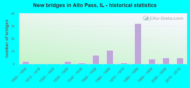
- New bridges - historical statistics
- 21900-1909
- 21930-1939
- 11940-1949
- 71950-1959
- 111960-1969
- 11970-1979
- 321980-1989
- 41990-1999
- 52000-2009
- 52010-2019
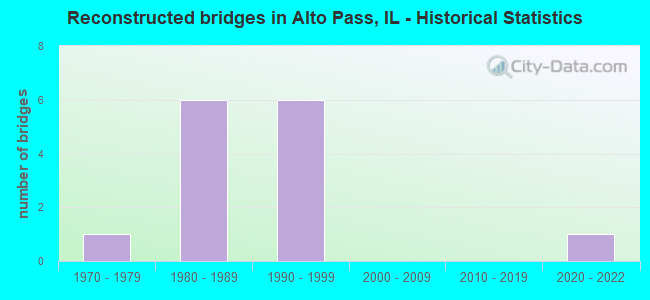
- Reconstructed bridges - Historical Statistics
- 11970-1979
- 61980-1989
- 61990-1999
- 02000-2009
- 02010-2019
- 12020-2022
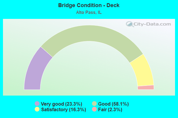
- Bridge Condition - Deck
- 23.3%Very good
- 58.1%Good
- 16.3%Satisfactory
- 2.3%Fair
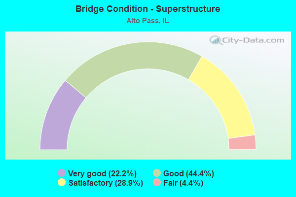
- Bridge Condition - Superstructure
- 22.2%Very good
- 44.4%Good
- 28.9%Satisfactory
- 4.4%Fair
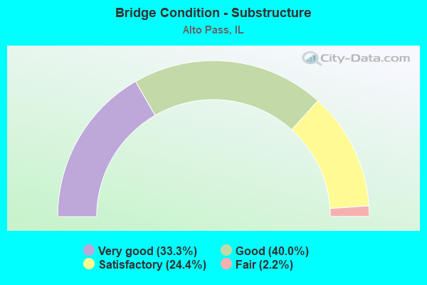
- Bridge Condition - Substructure
- 33.3%Very good
- 40.0%Good
- 24.4%Satisfactory
- 2.2%Fair
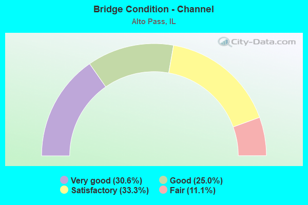
- Bridge Condition - Channel
- 30.6%Very good
- 25.0%Good
- 33.3%Satisfactory
- 11.1%Fair
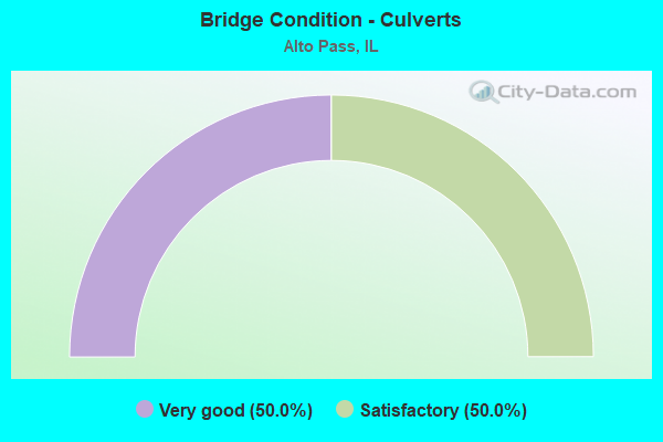
- Bridge Condition - Culverts
- 50.0%Very good
- 50.0%Satisfactory
Find on map >> Show street view
Structure Number: 820269, Location: .50 S MADISON CO LIN (Lat: 38.657122, Lng: -90.031428), Route carried "on" structure: Other road , Year Built: 1983, Status: Open, Structure Length: 8.37m (27.46ft), Average Daily Traffic: 2,300 (year 2016), Truck Traffic: 18%, Average Future Daily Traffic: 2,249 (year 2032), Design Load: HS 20+Mod, Features Intersected: CANTEEN CREEK, Facility Carried by Structure: I 255 NB RMP 1609
Minimum Vertical Clearance: 30+ m (98+ ft), Kilometerpoint: 0.225, Lanes on structure: 1, Base Highway Network: Yes (Inventory Route: 10255041, Subroute: 90), Owner: State Highway Agency, Approaching Roadway Width: 7.9m (25.9ft), Skew: 2 degrees, Material/Design: Steel continuous, Design/Construction: Stringer/Multi-beam, Number Of Spans In Main Unit: 3, Length of Maximum Span: 33.2m (108.9ft), Curb-To-Curb Width: 7.9m (25.9ft), Out-to-Out Width: 8.9m (29.2ft)
Condition: Deck: Good, Superstructure: Satisfactory, Substructure: Good, Channel: Very good, Operating Rating: 89.1 metric tons, Method Used To Determine Operating Rating: Load Factor (LF) rating reported by rating factor (RF) method using MS18 loading, Inventory Rating: 48.6 metric tons, Method Used To Determine Inventory Rating: Load Factor (LF) rating reported by rating factor (RF) method using MS18 loading, Structural Evaluation: Equal to present minimum criteria, Deck Geometry: High priority of corrective action, Waterway Adequacy: Equal to present desirable criteria, Approach Roadway Alignment: Equal to present desirable criteria, Designated Inspection Frequency: Every 24 months, Inspection Date: January 2021, Deck Structure Type: Concrete Cast-file-Place, Wearing Surface/Protective System: Wearing Surface: Bituminous, Membrane: Other, Deck Protection: Epoxy Coated Reinforcing
Find on map >> Show street view
Structure Number: 822044, Location: 500' s of madison co (Lat: 38.657506, Lng: -89.986361), Route carried "on" structure: State highway 159, Year Built: 2012, Status: Open, Structure Length: 1.21m (3.97ft), Average Daily Traffic: 16,700 (year 2021), Truck Traffic: 4%, Average Future Daily Traffic: 8,316 (year 2032), Design Load: HS 20, Features Intersected: Br of Canteen Creek
Minimum Vertical Clearance: 30+ m (98+ ft), Kilometerpoint: 50.371, Lanes on structure: 4, Base Highway Network: Yes, Owner: State Highway Agency, Approaching Roadway Width: 18.0m (59.1ft), Skew: 5 degrees, Material/Design: Concrete continuous, Design/Construction: Culvert, Number Of Spans In Main Unit: 2, Length of Maximum Span: 5.4m (17.7ft)
Condition: Channel: Very good, Culverts: Very good, Operating Rating: 68.7 metric tons, Method Used To Determine Operating Rating: Load Factor (LF) rating reported by rating factor (RF) method using MS18 loading, Inventory Rating: 41.1 metric tons, Method Used To Determine Inventory Rating: Load Factor (LF) rating reported by rating factor (RF) method using MS18 loading, Structural Evaluation: Equal to present desirable criteria, Waterway Adequacy: Equal to present minimum criteria, Approach Roadway Alignment: Equal to present desirable criteria, Designated Inspection Frequency: Every 48 months, Inspection Date: April 2021
Find on map >> Show street view
Structure Number: 90803000001003, Location: 3 MI NW OF POMONA (Lat: 37.638200, Lng: -89.342947), Route carried "on" structure: Federal lands road 346, Year Built: 1989, Year Reconstructed: 1, Status: Open, Structure Length: 3.66m (12.01ft), Average Daily Traffic: 100 (year 1992), Truck Traffic: 5%, Average Future Daily Traffic: 150 (year 2042), Design Load: HS 20, Features Intersected: CEDAR CREEK
Minimum Vertical Clearance: 30+ m (98+ ft), Kilometerpoint: 7.360, Lanes on structure: 2, Owner: U.S. Forest Service, Approaching Roadway Width: 6.1m (20.0ft), Material/Design: Prestressed concrete, Design/Construction: Box Beam or Girders - Multiple, Number Of Spans In Main Unit: 3, Length of Maximum Span: 15.2m (49.9ft), Curb-To-Curb Width: 7.4m (24.3ft), Out-to-Out Width: 7.4m (24.3ft)
Condition: Deck: Satisfactory, Superstructure: Satisfactory, Substructure: Satisfactory, Channel: Fair, Operating Rating: 32.7 metric tons, Method Used To Determine Operating Rating: Load and Resistance Factor Rating (LRFR) rating reported by rating factor(RF) method using HL-93 loadings, Inventory Rating: 25.3 metric tons, Method Used To Determine Inventory Rating: Load and Resistance Factor Rating (LRFR) rating reported by rating factor(RF) method using HL-93 loadings, Structural Evaluation: Equal to present minimum criteria, Deck Geometry: Equal to present minimum criteria, Waterway Adequacy: Equal to present desirable criteria, Approach Roadway Alignment: Equal to present minimum criteria, Designated Inspection Frequency: Every 24 months, Inspection Date: April 2021, Deck Structure Type: Concrete Precast Panels, Wearing Surface/Protective System: Wearing Surface: Other
Find on map >> Show street view
Structure Number: 90803000001004, Location: 2 MILES N. OF POMONA, IL (Lat: 37.637672, Lng: -89.343025), Route carried "on" structure: Federal lands road 750, Year Built: 2000, Status: Open, Structure Length: 2.35m (7.71ft), Average Daily Traffic: 125 (year 1992), Truck Traffic: 5%, Average Future Daily Traffic: 187 (year 2042), Design Load: H 20, Features Intersected: CAVE CREEK
Minimum Vertical Clearance: 30+ m (98+ ft), Kilometerpoint: 1.280, Lanes on structure: 2, Owner: U.S. Forest Service, Approaching Roadway Width: 7.3m (24.0ft), Skew: 3 degrees, Material/Design: Prestressed concrete, Design/Construction: Box Beam or Girders - Multiple, Number Of Spans In Main Unit: 1, Length of Maximum Span: 4.0m (13.1ft), Curb-To-Curb Width: 5.6m (18.4ft), Out-to-Out Width: 7.3m (24.0ft)
Condition: Deck: Good, Superstructure: Good, Substructure: Good, Channel: Fair, Operating Rating: 62.5 metric tons, Method Used To Determine Operating Rating: Load and Resistance Factor Rating (LRFR) rating reported by rating factor(RF) method using HL-93 loadings, Inventory Rating: 48.3 metric tons, Method Used To Determine Inventory Rating: Load and Resistance Factor Rating (LRFR) rating reported by rating factor(RF) method using HL-93 loadings, Structural Evaluation: Better than present minimum criteria, Deck Geometry: High priority of corrective action, Waterway Adequacy: Equal to present desirable criteria, Approach Roadway Alignment: Equal to present minimum criteria, Designated Inspection Frequency: Every 24 months, Inspection Date: April 2021, Deck Structure Type: Concrete Precast Panels, Wearing Surface/Protective System: Wearing Surface: Monolithic Concrete
Find on map >> Show street view
Structure Number: 910068, Location: 3 MI SO OF ALTO PASS (Lat: 37.525025, Lng: -89.313908), Route carried "on" structure: State highway 127, Year Built: 1989, Status: Open, Structure Length: 2.89m (9.48ft), Average Daily Traffic: 1,200 (year 2021), Truck Traffic: 11%, Average Future Daily Traffic: 1,130 (year 2032), Design Load: HS 20, Features Intersected: CLEAR CREEK
Minimum Vertical Clearance: 30+ m (98+ ft), Kilometerpoint: 48.569, Lanes on structure: 2, Owner: State Highway Agency, Approaching Roadway Width: 11.0m (36.1ft), Material/Design: Prestressed concrete, Design/Construction: Stringer/Multi-beam, Number Of Spans In Main Unit: 1, Length of Maximum Span: 28.0m (91.9ft), Curb-To-Curb Width: 9.1m (29.9ft), Out-to-Out Width: 10.1m (33.1ft)
Condition: Deck: Very good, Superstructure: Good, Substructure: Good, Channel: Satisfactory, Operating Rating: 77.1 metric tons, Method Used To Determine Operating Rating: Load Factor (LF) rating reported by rating factor (RF) method using MS18 loading, Inventory Rating: 39.5 metric tons, Method Used To Determine Inventory Rating: Load Factor (LF) rating reported by rating factor (RF) method using MS18 loading, Structural Evaluation: Better than present minimum criteria, Deck Geometry: Somewhat better than minimum adequacy, Waterway Adequacy: Equal to present desirable criteria, Approach Roadway Alignment: Equal to present desirable criteria, Designated Inspection Frequency: Every 48 months, Other Special Inspection Frequency: Every 12 months, Inspection Date: December 2019, Other Special Inspection Date: December 2021, Deck Structure Type: Concrete Cast-file-Place, Wearing Surface/Protective System: Deck Protection: Epoxy Coated Reinforcing
Find on map >> Show street view
Structure Number: 912014, Location: 1.2M S.OF ALTO PASS (Lat: 37.546897, Lng: -89.314225), Route carried "on" structure: State highway 127, Year Built: 1940, Status: Open, Structure Length: 0.78m (2.56ft), Average Daily Traffic: 1,200 (year 2021), Truck Traffic: 11%, Average Future Daily Traffic: 1,130 (year 2032), Design Load: H 15, Features Intersected: STREAM
Minimum Vertical Clearance: 30+ m (98+ ft), Kilometerpoint: 51.449, Lanes on structure: 2, Owner: State Highway Agency, Approaching Roadway Width: 7.9m (25.9ft), Skew: 3 degrees, Material/Design: Concrete continuous, Design/Construction: Culvert, Number Of Spans In Main Unit: 2, Length of Maximum Span: 3.7m (12.1ft)
Condition: Channel: Satisfactory, Culverts: Satisfactory, Operating Rating: 54.1 metric tons, Method Used To Determine Operating Rating: Field evaluation and documented engineering judgment, Inventory Rating: 32.4 metric tons, Method Used To Determine Inventory Rating: Field evaluation and documented engineering judgment, Structural Evaluation: Equal to present minimum criteria, Waterway Adequacy: Somewhat better than minimum adequacy, Approach Roadway Alignment: Equal to present desirable criteria, Designated Inspection Frequency: Every 24 months, Inspection Date: December 2020
Find on map >> Show street view
Structure Number: 913047, Location: 2 MI E OF ALTO PASS (Lat: 37.577808, Lng: -89.273894), Route carried "on" structure: County highway , Year Built: 1900, Year Reconstructed: 1976, Status: Open, Structure Length: 0.82m (2.69ft), Average Daily Traffic: 125 (year 2020), Truck Traffic: 8%, Average Future Daily Traffic: 424 (year 2032), Features Intersected: CREEK, Facility Carried by Structure: TR 17
Minimum Vertical Clearance: 30+ m (98+ ft), Kilometerpoint: 5.198, Lanes on structure: 1, Owner: Town or Township Highway Agency, Approaching Roadway Width: 5.5m (18.0ft), Material/Design: Steel, Design/Construction: Stringer/Multi-beam, Number Of Spans In Main Unit: 1, Length of Maximum Span: 7.9m (25.9ft), Curb-To-Curb Width: 5.8m (19.0ft), Out-to-Out Width: 5.9m (19.4ft)
Condition: Deck: Satisfactory, Superstructure: Fair, Substructure: Satisfactory, Channel: Good, Operating Rating: 32.4 metric tons, Method Used To Determine Operating Rating: Allowable Stress (AS) rating reported by rating factor (RF) method using MS18 loading, Inventory Rating: 23.3 metric tons, Method Used To Determine Inventory Rating: Allowable Stress (AS) rating reported by rating factor (RF) method using MS18 loading, Structural Evaluation: Somewhat better than minimum adequacy, Deck Geometry: High priority of corrective action, Waterway Adequacy: Better than present minimum criteria, Approach Roadway Alignment: Equal to present desirable criteria, Length Of Structure Improvement: 1.49m (4.89ft), Designated Inspection Frequency: Every 24 months, Inspection Date: March 2021, Bridge Improvement Cost: $55,000, Roadway Improvement Cost: $6,000, Total Project Cost: $83,000, Deck Structure Type: Wood or Timber, Wearing Surface/Protective System: Wearing Surface: Wood or Timber
Find on map >> Show street view
Structure Number: 913141, Location: 1.5 MI S ALTO PASS (Lat: 37.542753, Lng: -89.329125), Route carried "on" structure: County highway , Year Built: 1981, Status: Open, Structure Length: 2.74m (8.99ft), Average Daily Traffic: 50 (year 2020), Truck Traffic: 40%, Average Future Daily Traffic: 141 (year 2032), Design Load: HS 20, Features Intersected: SEMINARY FORK, Facility Carried by Structure: TR 62
Minimum Vertical Clearance: 30+ m (98+ ft), Kilometerpoint: 0.032, Lanes on structure: 2, Owner: Town or Township Highway Agency, Approaching Roadway Width: 5.2m (17.1ft), Material/Design: Concrete, Design/Construction: Channel Beam, Number Of Spans In Main Unit: 3, Length of Maximum Span: 9.8m (32.2ft), Curb-To-Curb Width: 6.9m (22.6ft), Out-to-Out Width: 6.9m (22.6ft)
Condition: Deck: Good, Superstructure: Good, Substructure: Satisfactory, Channel: Fair, Operating Rating: 42.1 metric tons, Method Used To Determine Operating Rating: Load Factor (LF) rating reported by rating factor (RF) method using MS18 loading, Inventory Rating: 25.3 metric tons, Method Used To Determine Inventory Rating: Load Factor (LF) rating reported by rating factor (RF) method using MS18 loading, Structural Evaluation: Equal to present minimum criteria, Deck Geometry: Somewhat better than minimum adequacy, Waterway Adequacy: Equal to present minimum criteria, Approach Roadway Alignment: Somewhat better than minimum adequacy, Designated Inspection Frequency: Every 24 months, Inspection Date: March 2021, Deck Structure Type: Concrete Precast Panels, Wearing Surface/Protective System: Wearing Surface: Gravel
Find on map >> Show street view
Structure Number: 913155, Location: 1.1M NW JCT.FAS 1911 (Lat: 37.576847, Lng: -89.274072), Route carried "on" structure: County highway , Year Built: 1982, Status: Open, Structure Length: 1.40m (4.59ft), Average Daily Traffic: 100 (year 2020), Truck Traffic: 12%, Average Future Daily Traffic: 141 (year 2032), Features Intersected: CREEK, Facility Carried by Structure: TR 19
Minimum Vertical Clearance: 30+ m (98+ ft), Kilometerpoint: 2.189, Lanes on structure: 1, Owner: Town or Township Highway Agency, Approaching Roadway Width: 3.7m (12.1ft), Material/Design: Steel, Design/Construction: Stringer/Multi-beam, Number Of Spans In Main Unit: 1, Length of Maximum Span: 13.4m (44.0ft), Curb-To-Curb Width: 4.1m (13.5ft), Out-to-Out Width: 4.3m (14.1ft)
Condition: Deck: Good, Superstructure: Satisfactory, Substructure: Satisfactory, Channel: Satisfactory, Operating Rating: 36.9 metric tons, Method Used To Determine Operating Rating: Allowable Stress (AS) rating reported by rating factor (RF) method using MS18 loading, Inventory Rating: 27.9 metric tons, Method Used To Determine Inventory Rating: Allowable Stress (AS) rating reported by rating factor (RF) method using MS18 loading, Structural Evaluation: Equal to present minimum criteria, Deck Geometry: Somewhat better than minimum adequacy, Waterway Adequacy: Better than present minimum criteria, Approach Roadway Alignment: Better than present minimum criteria, Length Of Structure Improvement: 2.10m (6.89ft), Designated Inspection Frequency: Every 24 months, Inspection Date: March 2021, Bridge Improvement Cost: $57,000, Roadway Improvement Cost: $6,000, Total Project Cost: $86,000, Deck Structure Type: Wood or Timber, Wearing Surface/Protective System: Wearing Surface: Wood or Timber
Find on map >> Show street view
Structure Number: 913194, Location: 2 MI W OF COBDEN (Lat: 37.522811, Lng: -89.303833), Route carried "on" structure: County highway , Year Built: 1993, Status: Open, Structure Length: 1.88m (6.17ft), Average Daily Traffic: 175 (year 2020), Truck Traffic: 1%, Average Future Daily Traffic: 293 (year 2032), Design Load: HS 20, Features Intersected: TRIB TO CLEAR CREEK, Facility Carried by Structure: TR 79A
Minimum Vertical Clearance: 30+ m (98+ ft), Kilometerpoint: 0.821, Lanes on structure: 2, Owner: Town or Township Highway Agency, Approaching Roadway Width: 7.3m (24.0ft), Skew: 2 degrees, Material/Design: Prestressed concrete, Design/Construction: Box Beam or Girders - Multiple, Number Of Spans In Main Unit: 1, Length of Maximum Span: 18.0m (59.1ft), Curb-To-Curb Width: 7.4m (24.3ft), Out-to-Out Width: 7.4m (24.3ft)
Condition: Deck: Good, Superstructure: Good, Substructure: Very good, Channel: Very good, Operating Rating: 44.1 metric tons, Method Used To Determine Operating Rating: Assigned rating based on Load Factor Design (LFD) reported by rating factor (RF) using MS18 loading, Inventory Rating: 32.4 metric tons, Method Used To Determine Inventory Rating: Assigned rating based on Load Factor Design (LFD) reported by rating factor (RF) using MS18 loading, Structural Evaluation: Better than present minimum criteria, Deck Geometry: Somewhat better than minimum adequacy, Waterway Adequacy: Equal to present desirable criteria, Approach Roadway Alignment: Better than present minimum criteria, Designated Inspection Frequency: Every 48 months, Inspection Date: March 2019, Deck Structure Type: Concrete Precast Panels
Find on map >> Show street view
Structure Number: 91324, Location: 1 MI S ALTO PASS (Lat: 37.549536, Lng: -89.326422), Route carried "on" structure: County highway , Year Built: 2013, Status: Open, Structure Length: 1.79m (5.87ft), Average Daily Traffic: 25 (year 2020), Average Future Daily Traffic: 100 (year 2035), Design Load: HS 25 or greater, Features Intersected: SEMINARY FORK, Facility Carried by Structure: TR 51
Minimum Vertical Clearance: 30+ m (98+ ft), Kilometerpoint: 1.899, Lanes on structure: 2, Owner: County Highway Agency, Approaching Roadway Width: 7.3m (24.0ft), Material/Design: Prestressed concrete, Design/Construction: Box Beam or Girders - Multiple, Number Of Spans In Main Unit: 1, Length of Maximum Span: 17.1m (56.1ft), Curb-To-Curb Width: 7.3m (24.0ft), Out-to-Out Width: 7.3m (24.0ft)
Condition: Deck: Good, Superstructure: Good, Substructure: Very good, Channel: Very good, Operating Rating: 42.1 metric tons, Method Used To Determine Operating Rating: Assigned ratings based on Load and Resistance Factor Design (LRFD) reported by rating factor (RF) using HL93 loadings, Inventory Rating: 32.4 metric tons, Method Used To Determine Inventory Rating: Assigned ratings based on Load and Resistance Factor Design (LRFD) reported by rating factor (RF) using HL93 loadings, Structural Evaluation: Better than present minimum criteria, Deck Geometry: Equal to present minimum criteria, Waterway Adequacy: Equal to present desirable criteria, Approach Roadway Alignment: Equal to present desirable criteria, Designated Inspection Frequency: Every 48 months, Inspection Date: March 2019, Deck Structure Type: Concrete Precast Panels, Wearing Surface/Protective System: Wearing Surface: Gravel
Find on map >> Show street view
Structure Number: 913245, Location: 1.4MI EAST ALTO PASS (Lat: 37.584144, Lng: -89.294050), Route carried "on" structure: County highway , Year Built: 2018, Status: Open, Structure Length: 1.48m (4.86ft), Average Daily Traffic: 50 (year 2015), Truck Traffic: 40%, Average Future Daily Traffic: 67 (year 2032), Design Load: HS 25 or greater, Features Intersected: CEDAR CREEK, Facility Carried by Structure: UNION SPRINGS RD
Minimum Vertical Clearance: 30+ m (98+ ft), Kilometerpoint: 2.108, Lanes on structure: 2, Owner: Town or Township Highway Agency, Approaching Roadway Width: 7.3m (24.0ft), Skew: 2 degrees, Material/Design: Prestressed concrete, Design/Construction: Box Beam or Girders - Multiple, Number Of Spans In Main Unit: 1, Length of Maximum Span: 14.0m (45.9ft), Curb-To-Curb Width: 7.3m (24.0ft), Out-to-Out Width: 7.3m (24.0ft)
Condition: Deck: Very good, Superstructure: Very good, Substructure: Very good, Channel: Very good, Operating Rating: 46.7 metric tons, Method Used To Determine Operating Rating: Load and Resistance Factor Rating (LRFR) rating reported by rating factor(RF) method using HL-93 loadings, Inventory Rating: 36.6 metric tons, Method Used To Determine Inventory Rating: Load and Resistance Factor Rating (LRFR) rating reported by rating factor(RF) method using HL-93 loadings, Structural Evaluation: Equal to present desirable criteria, Deck Geometry: Equal to present minimum criteria, Waterway Adequacy: Equal to present desirable criteria, Approach Roadway Alignment: Equal to present desirable criteria, Designated Inspection Frequency: Every 48 months, Inspection Date: June 2020, Deck Structure Type: Concrete Precast Panels, Wearing Surface/Protective System: Wearing Surface: Gravel
Find on map >> Show street view
Structure Number: 1631, Location: 0.25 M NW WOOD P2 (Lat: 41.639403, Lng: -87.662597), Route carried "under" structure: Other road , Year Built: 1900, Structure Length: 0. m, Average Daily Traffic: 4,850 (year 2021), Truck Traffic: 4%, Features Intersected: THORNTON RD, Facility Carried by Structure: RR
Minimum Vertical Clearance: 3.66m (12.01ft), Kilometerpoint: 4.747, Lanes under structure: 2, Material/Design: Steel, Length of Maximum Span: 4.9m (16.1ft)
Find on map >> Show street view
Structure Number: 600012, Location: JCT 70 W COLLNVILLE (Lat: 38.680486, Lng: -90.011733), Route carried "under" structure: State highway 157, Year Built: 1960, Structure Length: 0. m, Average Daily Traffic: 22,500 (year 2021), Truck Traffic: 4%, Features Intersected: ILL 157, Facility Carried by Structure: FAI 70 EB
Minimum Vertical Clearance: 4.90m (16.08ft), Kilometerpoint: 26.006, Lanes on structure: 3, Lanes under structure: 4, Material/Design: Steel continuous, Design/Construction: Stringer/Multi-beam, Length of Maximum Span: 26.6m (87.3ft)
Find on map >> Show street view
Structure Number: 600013, Location: JCT FAI 70 & ILL 157 (Lat: 38.680644, Lng: -90.011700), Route carried "under" structure: State highway 157, Year Built: 1960, Structure Length: 0. m, Average Daily Traffic: 22,500 (year 2021), Truck Traffic: 4%, Features Intersected: ILL 157, Facility Carried by Structure: FAI 70 WB
Minimum Vertical Clearance: 4.90m (16.08ft), Kilometerpoint: 26.038, Lanes on structure: 3, Lanes under structure: 4, Material/Design: Steel continuous, Design/Construction: Stringer/Multi-beam, Length of Maximum Span: 26.6m (87.3ft)
Find on map >> Show street view
Structure Number: 600014, Location: COLLINSVILLE (Lat: 38.687186, Lng: -90.004508), Route carried "under" structure: Other road , Year Built: 1959, Structure Length: 0. m, Average Daily Traffic: 17,700 (year 2021), Truck Traffic: 4%, Features Intersected: COLLINSVLE BELTLINE, Facility Carried by Structure: I-55/70 EB
Minimum Vertical Clearance: 4.88m (16.01ft), Kilometerpoint: 0.435, Lanes on structure: 2, Lanes under structure: 4, Material/Design: Steel continuous, Design/Construction: Stringer/Multi-beam, Length of Maximum Span: 34.1m (111.9ft)
Find on map >> Show street view
Structure Number: 600015, Location: COLLINSVILLE (Lat: 38.687169, Lng: -90.004650), Route carried "under" structure: Other road , Year Built: 1959, Structure Length: 0. m, Average Daily Traffic: 17,700 (year 2021), Truck Traffic: 4%, Features Intersected: COLLINSVLE BELTLINE, Facility Carried by Structure: I-55/70 WB
Minimum Vertical Clearance: 5.41m (17.75ft), Kilometerpoint: 0.418, Lanes on structure: 2, Lanes under structure: 4, Material/Design: Steel continuous, Design/Construction: Stringer/Multi-beam, Length of Maximum Span: 34.1m (111.9ft)
Find on map >> Show street view
Structure Number: 600146, Location: 1.5 MI E OF ILL 111 (Lat: 38.662789, Lng: -90.066192), Route carried "under" structure: Interstate 55, Year Built: 1961, Structure Length: 0. m, Average Daily Traffic: 51,700 (year 2021), Truck Traffic: 16%, Features Intersected: I-55/70, Facility Carried by Structure: SAND PRAIRIE ROAD
Minimum Vertical Clearance: 4.90m (16.08ft), Kilometerpoint: 12.456, Lanes on structure: 2, Lanes under structure: 6, Material/Design: Steel continuous, Design/Construction: Stringer/Multi-beam, Length of Maximum Span: 21.9m (71.9ft)
Find on map >> Show street view
Structure Number: 600205, Location: 1.4MI W OF ILL 157 (Lat: 38.671769, Lng: -90.033089), Route carried "under" structure: Interstate 55, Year Built: 1986, Structure Length: 0. m, Average Daily Traffic: 49,700 (year 2021), Truck Traffic: 17%, Features Intersected: FAI 55,70;US 40
Minimum Vertical Clearance: 4.95m (16.24ft), Kilometerpoint: 15.514, Lanes on structure: 2, Lanes under structure: 6, Material/Design: Steel continuous, Design/Construction: Stringer/Multi-beam, Length of Maximum Span: 33.2m (108.9ft)
Find on map >> Show street view
Structure Number: 600206, Location: And over Ramps 5+6 (Lat: 38.672886, Lng: -90.029028), Route carried "under" structure: Interstate 55, Year Built: 1986, Structure Length: 0. m, Average Daily Traffic: 56,100 (year 2021), Truck Traffic: 18%, Features Intersected: I-55/70
Minimum Vertical Clearance: 5.28m (17.32ft), Kilometerpoint: 15.836, Lanes on structure: 3, Lanes under structure: 6, Material/Design: Steel continuous, Design/Construction: Stringer/Multi-beam, Length of Maximum Span: 43.6m (143.0ft)
Find on map >> Show street view
Structure Number: 600207, Location: And over Ramps 5+6 (Lat: 38.672767, Lng: -90.029456), Route carried "under" structure: Interstate 55, Year Built: 1986, Structure Length: 0. m, Average Daily Traffic: 56,100 (year 2021), Truck Traffic: 18%, Features Intersected: I-55/70
Minimum Vertical Clearance: 5.26m (17.26ft), Kilometerpoint: 15.787, Lanes on structure: 3, Lanes under structure: 6, Material/Design: Steel continuous, Design/Construction: Stringer/Multi-beam, Length of Maximum Span: 43.6m (143.0ft)
Find on map >> Show street view
Structure Number: 600211, Location: 1.35MI W OF ILL 157 (Lat: 38.671519, Lng: -90.033961), Route carried "under" structure: Interstate 55, Year Built: 1986, Structure Length: 0. m, Average Daily Traffic: 49,700 (year 2021), Truck Traffic: 17%, Features Intersected: FAI 55/70
Minimum Vertical Clearance: 5.59m (18.34ft), Kilometerpoint: 15.417, Lanes on structure: 2, Lanes under structure: 6, Material/Design: Steel continuous, Design/Construction: Stringer/Multi-beam, Length of Maximum Span: 47.5m (155.8ft)
Find on map >> Show street view
Structure Number: 600214, Location: N OF FAI 55,70;US 40 (Lat: 38.676150, Lng: -90.029989), Route carried "under" structure: Other road , Year Built: 1987, Structure Length: 0. m, Average Daily Traffic: 5,000 (year 2021), Truck Traffic: 12%, Features Intersected: RP 1/RDWY B, Facility Carried by Structure: FAI 255 NB
Minimum Vertical Clearance: 5.59m (18.34ft), Kilometerpoint: 2.044, Lanes on structure: 3, Lanes under structure: 4, Material/Design: Steel continuous, Design/Construction: Stringer/Multi-beam, Length of Maximum Span: 47.9m (157.2ft)
Find on map >> Show street view
Structure Number: 600214, Location: N OF FAI 55,70;US 40 (Lat: 38.675811, Lng: -90.029611), Route carried "under" structure: Other road , Year Built: 1987, Structure Length: 0. m, Average Daily Traffic: 6,700 (year 2021), Truck Traffic: 22%, Features Intersected: RP 1/RDWY B, Facility Carried by Structure: FAI 255 NB
Minimum Vertical Clearance: 5.59m (18.34ft), Kilometerpoint: 0.451, Lanes on structure: 3, Lanes under structure: 4, Material/Design: Steel continuous, Design/Construction: Stringer/Multi-beam, Length of Maximum Span: 47.9m (157.2ft)
Find on map >> Show street view
Structure Number: 600216, Location: 1.2MI W ILL 157 (Lat: 38.690653, Lng: -90.030017), Route carried "under" structure: Other road , Year Built: 1987, Structure Length: 0. m, Average Daily Traffic: 9,650 (year 2021), Truck Traffic: 5%, Features Intersected: HORSESHOE LAKE ROAD, Facility Carried by Structure: FAI 255 NB
Minimum Vertical Clearance: 8.97m (29.43ft), Kilometerpoint: 6.148, Lanes on structure: 3, Lanes under structure: 2, Material/Design: Steel continuous, Design/Construction: Stringer/Multi-beam, Length of Maximum Span: 48.8m (160.1ft)
Find on map >> Show street view
Structure Number: 600217, Location: 1.2MI W ILL157 (Lat: 38.690761, Lng: -90.030389), Route carried "under" structure: Other road , Year Built: 1987, Structure Length: 0. m, Average Daily Traffic: 9,650 (year 2021), Truck Traffic: 5%, Features Intersected: HORSESHOE LAKE ROAD, Facility Carried by Structure: FAI 255 SB
Minimum Vertical Clearance: 9.02m (29.59ft), Kilometerpoint: 6.099, Lanes on structure: 3, Lanes under structure: 2, Material/Design: Steel continuous, Design/Construction: Stringer/Multi-beam, Length of Maximum Span: 48.8m (160.1ft)
Find on map >> Show street view
Structure Number: 600238, Location: .1M SE FARMNT RACETK (Lat: 38.659789, Lng: -90.030636), Route carried "under" structure: Other road , Year Built: 1986, Structure Length: 0. m, Average Daily Traffic: 10,400 (year 2021), Truck Traffic: 8%, Features Intersected: COLLINSVILLE RD, Facility Carried by Structure: FAI 255 NB
Minimum Vertical Clearance: 5.23m (17.16ft), Kilometerpoint: 1.432, Lanes on structure: 3, Lanes under structure: 4, Material/Design: Steel, Design/Construction: Stringer/Multi-beam, Length of Maximum Span: 36.9m (121.1ft)
Find on map >> Show street view
Structure Number: 600239, Location: .1M SE FARMNT RACETK (Lat: 38.659781, Lng: -90.030842), Route carried "under" structure: Other road , Year Built: 1986, Structure Length: 0. m, Average Daily Traffic: 10,400 (year 2021), Truck Traffic: 8%, Features Intersected: COLLINSVILLE RD, Facility Carried by Structure: FAI 255 SB
Minimum Vertical Clearance: 5.26m (17.26ft), Kilometerpoint: 1.400, Lanes on structure: 3, Lanes under structure: 4, Material/Design: Steel, Design/Construction: Stringer/Multi-beam, Length of Maximum Span: 36.9m (121.1ft)
Find on map >> Show street view
Structure Number: 600253, Location: N OF FAI 55,70;US 40 (Lat: 38.675822, Lng: -90.030236), Route carried "under" structure: Other road , Year Built: 1987, Structure Length: 0. m, Average Daily Traffic: 5,000 (year 2021), Truck Traffic: 12%, Features Intersected: RP 1/RDWY B, Facility Carried by Structure: FAI 255 SB
Minimum Vertical Clearance: 5.23m (17.16ft), Kilometerpoint: 1.996, Lanes on structure: 3, Lanes under structure: 4, Material/Design: Steel continuous, Design/Construction: Stringer/Multi-beam, Length of Maximum Span: 58.5m (191.9ft)
Find on map >> Show street view
Structure Number: 600253, Location: N OF FAI 55,70;US 40 (Lat: 38.675597, Lng: -90.029950), Route carried "under" structure: Other road , Year Built: 1987, Structure Length: 0. m, Average Daily Traffic: 6,700 (year 2021), Truck Traffic: 22%, Features Intersected: RP 1/RDWY B, Facility Carried by Structure: FAI 255 SB
Minimum Vertical Clearance: 5.23m (17.16ft), Kilometerpoint: 0.499, Lanes on structure: 3, Lanes under structure: 4, Material/Design: Steel continuous, Design/Construction: Stringer/Multi-beam, Length of Maximum Span: 58.5m (191.9ft)
Find on map >> Show street view
Structure Number: 600263, Location: C-VILLE-E OF RAMON'S (Lat: 38.660147, Lng: -90.017911), Route carried "under" structure: Other road , Year Built: 1992, Structure Length: 0. m, Average Daily Traffic: 5,500 (year 2016), Truck Traffic: 9%, Features Intersected: ST LOUIS ROAD, Facility Carried by Structure: ILL 157
Minimum Vertical Clearance: 4.60m (15.09ft), Kilometerpoint: 2.559, Lanes on structure: 3, Lanes under structure: 4, Material/Design: Steel continuous, Design/Construction: Stringer/Multi-beam, Length of Maximum Span: 21.6m (70.9ft)