Bridge Statistics for Amsterdam, New York (NY)
Condition, Traffic, Stress, Structural Evaluation, Project Costs
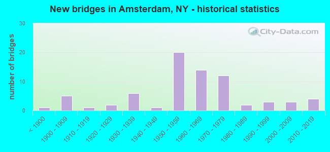
- New bridges - historical statistics
- 1Before 1900
- 51900-1909
- 11910-1919
- 21920-1929
- 61930-1939
- 11940-1949
- 201950-1959
- 141960-1969
- 121970-1979
- 21980-1989
- 31990-1999
- 32000-2009
- 42010-2019
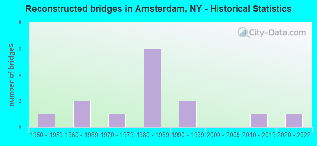
- Reconstructed bridges - Historical Statistics
- 11950-1959
- 21960-1969
- 11970-1979
- 61980-1989
- 21990-1999
- 02000-2009
- 12010-2019
- 12020-2022
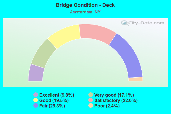
- Bridge Condition - Deck
- 9.8%Excellent
- 17.1%Very good
- 19.5%Good
- 22.0%Satisfactory
- 29.3%Fair
- 2.4%Poor
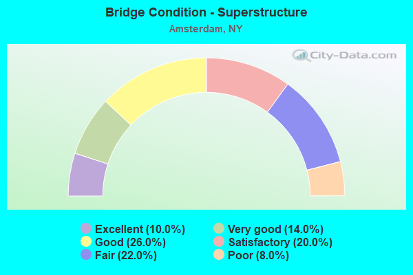
- Bridge Condition - Superstructure
- 10.0%Excellent
- 14.0%Very good
- 26.0%Good
- 20.0%Satisfactory
- 22.0%Fair
- 8.0%Poor
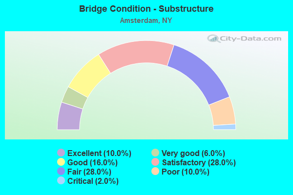
- Bridge Condition - Substructure
- 10.0%Excellent
- 6.0%Very good
- 16.0%Good
- 28.0%Satisfactory
- 28.0%Fair
- 10.0%Poor
- 2.0%Critical
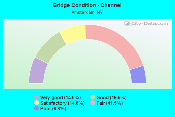
- Bridge Condition - Channel
- 14.6%Very good
- 19.5%Good
- 14.6%Satisfactory
- 41.5%Fair
- 9.8%Poor
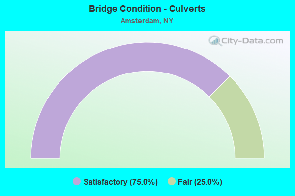
- Bridge Condition - Culverts
- 75.0%Satisfactory
- 25.0%Fair
Find on map >> Show street view
Structure Number: 100295, Location: 0.9 MI W JCT RTS 5S & 30 (Lat: 42.933975, Lng: -74.214803), Route carried "on" structure: State highway 5S, Year Built: 1956, Year Reconstructed: 1981, Status: Open, Structure Length: 6.77m (22.21ft), Average Daily Traffic: 6,719 (year 2020), Truck Traffic: 17%, Average Future Daily Traffic: 8,162 (year 2040), Design Load: HS 20, Features Intersected: FLORIDA AVENUE, SO CHUCT
Minimum Vertical Clearance: 30+ m (98+ ft), Kilometerpoint: 50.442, Lanes on structure: 2, Lanes under structure: 2, Base Highway Network: Yes, Owner: State Highway Agency, Approaching Roadway Width: 13.1m (43.0ft), Skew: 2 degrees, Material/Design: Steel, Design/Construction: Stringer/Multi-beam, Number Of Spans In Main Unit: 3, Length of Maximum Span: 21.9m (71.9ft), Curb-To-Curb Width: 13.1m (43.0ft), Out-to-Out Width: 14.0m (45.9ft)
Condition: Deck: Good, Superstructure: Good, Substructure: Fair, Channel: Satisfactory, Operating Rating: 65.1 metric tons, Method Used To Determine Operating Rating: Load and Resistance Factor Rating (LRFR) rating reported by rating factor(RF) method using HL-93 loadings, Inventory Rating: 50.2 metric tons, Method Used To Determine Inventory Rating: Load and Resistance Factor Rating (LRFR) rating reported by rating factor(RF) method using HL-93 loadings, Structural Evaluation: Somewhat better than minimum adequacy, Deck Geometry: Somewhat better than minimum adequacy, Underclear: Meets minimum limits, Waterway Adequacy: Somewhat better than minimum adequacy, Approach Roadway Alignment: Equal to present desirable criteria, Length Of Structure Improvement: 6.76m (22.18ft), Designated Inspection Frequency: Every 24 months, Inspection Date: July 2020, Bridge Improvement Cost: $1,577,000, Roadway Improvement Cost: $924,000, Total Project Cost: $2,501,000 ( Estimate for 2021), Deck Structure Type: Concrete Cast-file-Place, Wearing Surface/Protective System: Wearing Surface: Bituminous, Membrane: Other, Deck Protection: Epoxy Coated Reinforcing
Find on map >> Show street view
Structure Number: 100296, Location: 1.0 MI W JCT RTS 5S & 160 (Lat: 42.928342, Lng: -74.198450), Route carried "on" structure: State highway 5S, Year Built: 1960, Year Reconstructed: 1992, Status: Open, Structure Length: 5.21m (17.09ft), Average Daily Traffic: 6,719 (year 2020), Truck Traffic: 16%, Average Future Daily Traffic: 8,162 (year 2040), Design Load: HS 20, Features Intersected: 30 2504 2004 Northbound
Minimum Vertical Clearance: 30+ m (98+ ft), Kilometerpoint: 51.987, Lanes on structure: 2, Lanes under structure: 4, Base Highway Network: Yes, Owner: State Highway Agency, Approaching Roadway Width: 11.0m (36.1ft), Material/Design: Steel, Design/Construction: Stringer/Multi-beam, Number Of Spans In Main Unit: 3, Length of Maximum Span: 24.1m (79.1ft), Curb-To-Curb Width: 10.5m (34.4ft), Out-to-Out Width: 11.4m (37.4ft)
Condition: Deck: Fair, Superstructure: Satisfactory, Substructure: Poor, Operating Rating: 77.1 metric tons, Method Used To Determine Operating Rating: Load and Resistance Factor Rating (LRFR) rating reported by rating factor(RF) method using HL-93 loadings, Inventory Rating: 59.3 metric tons, Method Used To Determine Inventory Rating: Load and Resistance Factor Rating (LRFR) rating reported by rating factor(RF) method using HL-93 loadings, Structural Evaluation: Meets minimum limits, Deck Geometry: Meets minimum limits, Underclear: High priority of corrective action, Approach Roadway Alignment: Equal to present desirable criteria, Length Of Structure Improvement: 5.21m (17.09ft), Designated Inspection Frequency: Every 24 months, Inspection Date: September 2020, Bridge Improvement Cost: $954,000, Roadway Improvement Cost: $559,000, Total Project Cost: $1,513,000 ( Estimate for 2021), Deck Structure Type: Concrete Cast-file-Place, Wearing Surface/Protective System: Wearing Surface: Integral Concrete
Find on map >> Show street view
Structure Number: 100297, Location: 1.5 MI E JCT RTS 5S & 160 (Lat: 42.915789, Lng: -74.153419), Route carried "on" structure: State highway 5S, Year Built: 1957, Year Reconstructed: 2018, Status: Open, Structure Length: 1.95m (6.40ft), Average Daily Traffic: 2,194 (year 2020), Truck Traffic: 19%, Average Future Daily Traffic: 2,288 (year 2040), Design Load: HL 93, Features Intersected: TERWILLEGER CREEK
Minimum Vertical Clearance: 30+ m (98+ ft), Kilometerpoint: 55.993, Lanes on structure: 2, Base Highway Network: Yes, Owner: State Highway Agency, Approaching Roadway Width: 7.3m (24.0ft), Skew: 2 degrees, Material/Design: Prestressed concrete, Design/Construction: Tee Beam, Number Of Spans In Main Unit: 1, Length of Maximum Span: 18.2m (59.7ft), Curb-To-Curb Width: 12.2m (40.0ft), Out-to-Out Width: 13.5m (44.3ft)
Condition: Deck: Excellent, Superstructure: Excellent, Substructure: Excellent, Channel: Very good, Operating Rating: 77.4 metric tons, Method Used To Determine Operating Rating: Load and Resistance Factor Rating (LRFR) rating reported by rating factor(RF) method using HL-93 loadings, Inventory Rating: 42.4 metric tons, Method Used To Determine Inventory Rating: Load and Resistance Factor Rating (LRFR) rating reported by rating factor(RF) method using HL-93 loadings, Structural Evaluation: Superior to present desirable criteria, Deck Geometry: Equal to present minimum criteria, Waterway Adequacy: Meets minimum limits, Approach Roadway Alignment: Equal to present desirable criteria, Length Of Structure Improvement: 1.95m (6.40ft), Designated Inspection Frequency: Every 24 months, Inspection Date: October 2020, Bridge Improvement Cost: $1,135,000, Roadway Improvement Cost: $665,000, Total Project Cost: $1,800,000 ( Estimate for 2021), Wearing Surface/Protective System: Wearing Surface: Epoxy Overlay
Find on map >> Show street view
Structure Number: 100298, Location: 31MI E JCT RTS 160+5S (Lat: 42.909489, Lng: -74.124417), Route carried "on" structure: State highway 5S, Year Built: 1928, Year Reconstructed: 1956, Status: Open, Structure Length: 0.79m (2.59ft), Average Daily Traffic: 2,194 (year 2020), Truck Traffic: 19%, Average Future Daily Traffic: 2,288 (year 2040), Design Load: HS 20, Features Intersected: UNNAMED CREEK
Minimum Vertical Clearance: 30+ m (98+ ft), Kilometerpoint: 58.535, Lanes on structure: 2, Base Highway Network: Yes, Owner: State Highway Agency, Approaching Roadway Width: 11.0m (36.1ft), Material/Design: Concrete, Design/Construction: Slab, Number Of Spans In Main Unit: 1, Length of Maximum Span: 6.7m (22.0ft), Curb-To-Curb Width: 12.7m (41.7ft), Out-to-Out Width: 13.6m (44.6ft)
Condition: Deck: Good, Superstructure: Fair, Substructure: Fair, Channel: Poor, Operating Rating: 66.2 metric tons, Method Used To Determine Operating Rating: Load Factor (LF), Inventory Rating: 39.9 metric tons, Method Used To Determine Inventory Rating: Load Factor (LF), Structural Evaluation: Somewhat better than minimum adequacy, Deck Geometry: Equal to present minimum criteria, Waterway Adequacy: Equal to present desirable criteria, Approach Roadway Alignment: Equal to present desirable criteria, Length Of Structure Improvement: 0.79m (2.59ft), Designated Inspection Frequency: Every 24 months, Inspection Date: March 2020, Bridge Improvement Cost: $356,000, Roadway Improvement Cost: $209,000, Total Project Cost: $565,000 ( Estimate for 2021), Wearing Surface/Protective System: Wearing Surface: Bituminous, Membrane: Other
Find on map >> Show street view
Structure Number: 102104, Location: 2.5 MI SE JCT RTS 30 &161 (Lat: 42.872675, Lng: -74.208269), Route carried "on" structure: State highway 30, Year Built: 1999, Status: Open, Structure Length: 2.74m (8.99ft), Average Daily Traffic: 2,277 (year 2020), Truck Traffic: 9%, Average Future Daily Traffic: 2,291 (year 2040), Design Load: HS 25 or greater, Features Intersected: SO CHUCTANUNDA CK
Minimum Vertical Clearance: 30+ m (98+ ft), Kilometerpoint: 4.344, Lanes on structure: 2, Base Highway Network: Yes, Owner: State Highway Agency, Approaching Roadway Width: 9.1m (29.9ft), Skew: 4 degrees, Material/Design: Steel, Design/Construction: Stringer/Multi-beam, Number Of Spans In Main Unit: 1, Length of Maximum Span: 25.9m (85.0ft), Curb-To-Curb Width: 9.1m (29.9ft), Out-to-Out Width: 9.8m (32.2ft)
Condition: Deck: Satisfactory, Superstructure: Satisfactory, Substructure: Good, Channel: Fair, Operating Rating: 77.1 metric tons, Method Used To Determine Operating Rating: Load Factor (LF), Inventory Rating: 40.8 metric tons, Method Used To Determine Inventory Rating: Load Factor (LF), Structural Evaluation: Equal to present minimum criteria, Deck Geometry: Meets minimum limits, Waterway Adequacy: Somewhat better than minimum adequacy, Approach Roadway Alignment: Equal to present desirable criteria, Length Of Structure Improvement: 2.74m (8.99ft), Designated Inspection Frequency: Every 24 months, Inspection Date: July 2021, Bridge Improvement Cost: $631,000, Roadway Improvement Cost: $369,000, Total Project Cost: $1,000,000 ( Estimate for 2021), Deck Structure Type: Concrete Cast-file-Place, Wearing Surface/Protective System: Wearing Surface: Integral Concrete, Deck Protection: Epoxy Coated Reinforcing
Find on map >> Show street view
Structure Number: 102105, Location: IN SOUTH AMSTERDAM (Lat: 42.923986, Lng: -74.201797), Route carried "on" structure: State highway 30, Year Built: 1953, Year Reconstructed: 1992, Status: Open, Structure Length: 7.22m (23.69ft), Average Daily Traffic: 4,106 (year 2018), Truck Traffic: 7%, Average Future Daily Traffic: 4,987 (year 2040), Design Load: HS 20, Features Intersected: 90IX EB, RTE I90
Minimum Vertical Clearance: 30+ m (98+ ft), Kilometerpoint: 11.263, Lanes on structure: 2, Lanes under structure: 6, Base Highway Network: Yes, Owner: State Toll Authority, Approaching Roadway Width: 12.5m (41.0ft), Skew: 1 degrees, Material/Design: Steel, Design/Construction: Stringer/Multi-beam, Number Of Spans In Main Unit: 4, Length of Maximum Span: 20.4m (66.9ft), Curb-To-Curb Width: 12.2m (40.0ft), Out-to-Out Width: 13.1m (43.0ft)
Condition: Deck: Good, Superstructure: Satisfactory, Substructure: Satisfactory, Operating Rating: 78.0 metric tons, Method Used To Determine Operating Rating: Load Factor (LF), Inventory Rating: 46.3 metric tons, Method Used To Determine Inventory Rating: Load Factor (LF), Structural Evaluation: Equal to present minimum criteria, Deck Geometry: Equal to present minimum criteria, Underclear: High priority of corrective action, Approach Roadway Alignment: Equal to present desirable criteria, Length Of Structure Improvement: 7.22m (23.69ft), Designated Inspection Frequency: Every 24 months, Inspection Date: June 2021, Bridge Improvement Cost: $1,504,000, Roadway Improvement Cost: $881,000, Total Project Cost: $2,385,000 ( Estimate for 2021), Deck Structure Type: Concrete Cast-file-Place, Wearing Surface/Protective System: Wearing Surface: Integral Concrete, Deck Protection: Epoxy Coated Reinforcing
Find on map >> Show street view
Structure Number: 102106, Location: 0.3 MI N JCT RTS 5S & 30 (Lat: 42.930683, Lng: -74.196833), Route carried "on" structure: State highway , Year Built: 1960, Status: Open, Structure Length: 5.33m (17.49ft), Average Daily Traffic: 324 (year 2020), Average Future Daily Traffic: 400 (year 2040), Design Load: HS 20, Features Intersected: 30 NB 30 25042006, RTE 3, Facility Carried by Structure: GRIEME AVE
Minimum Vertical Clearance: 32.69m (107.25ft), Kilometerpoint: 0.177, Lanes on structure: 2, Lanes under structure: 4, Owner: State Highway Agency, Approaching Roadway Width: 7.9m (25.9ft), Material/Design: Steel, Design/Construction: Stringer/Multi-beam, Number Of Spans In Main Unit: 3, Length of Maximum Span: 24.0m (78.7ft), Curb or Sidewalk Widths: Left: 1.6m (5.2ft), Right: 1.6m (5.2ft), Curb-To-Curb Width: 7.9m (25.9ft), Out-to-Out Width: 11.6m (38.1ft)
Condition: Deck: Satisfactory, Superstructure: Good, Substructure: Poor, Operating Rating: 71.6 metric tons, Method Used To Determine Operating Rating: Load and Resistance Factor Rating (LRFR) rating reported by rating factor(RF) method using HL-93 loadings, Inventory Rating: 55.1 metric tons, Method Used To Determine Inventory Rating: Load and Resistance Factor Rating (LRFR) rating reported by rating factor(RF) method using HL-93 loadings, Structural Evaluation: Meets minimum limits, Deck Geometry: Somewhat better than minimum adequacy, Underclear: Meets minimum limits, Approach Roadway Alignment: Equal to present desirable criteria, Length Of Structure Improvement: 5.33m (17.49ft), Designated Inspection Frequency: Every 24 months, Inspection Date: April 2020, Bridge Improvement Cost: $1,002,000, Roadway Improvement Cost: $587,000, Total Project Cost: $1,588,000 ( Estimate for 2021), Deck Structure Type: Concrete Cast-file-Place, Wearing Surface/Protective System: Wearing Surface: Bituminous
Find on map >> Show street view
Structure Number: 1021079, Location: .5 MI N JCT SH 5S & SH 30 (Lat: 42.933056, Lng: -74.195050), Route carried "on" structure: State highway 30, Year Built: 1960, Year Reconstructed: 2020, Status: Open, Structure Length: 5.39m (17.68ft), Average Daily Traffic: 15,934 (year 2017), Truck Traffic: 9%, Average Future Daily Traffic: 16,008 (year 2040), Design Load: HS 20, Features Intersected: RECREATION TRAIL, CLEVEL
Minimum Vertical Clearance: 30+ m (98+ ft), Kilometerpoint: 12.405, Lanes on structure: 6, Lanes under structure: 4, Base Highway Network: Yes, Owner: State Highway Agency, Approaching Roadway Width: 18.9m (62.0ft), Skew: 30 degrees, Material/Design: Steel, Design/Construction: Stringer/Multi-beam, Number Of Spans In Main Unit: 4, Length of Maximum Span: 14.3m (46.9ft), Curb-To-Curb Width: 26.2m (86.0ft), Out-to-Out Width: 27.7m (90.9ft)
Condition: Deck: Very good, Superstructure: Good, Substructure: Poor, Operating Rating: 74.4 metric tons, Method Used To Determine Operating Rating: Load Factor (LF), Inventory Rating: 44.5 metric tons, Method Used To Determine Inventory Rating: Load Factor (LF), Structural Evaluation: Meets minimum limits, Deck Geometry: Equal to present minimum criteria, Underclear: High priority of corrective action, Approach Roadway Alignment: Equal to present desirable criteria, Length Of Structure Improvement: 5.39m (17.68ft), Designated Inspection Frequency: Every 24 months, Inspection Date: November 2020, Bridge Improvement Cost: $2,787,000, Roadway Improvement Cost: $1,632,000, Total Project Cost: $4,419,000 ( Estimate for 2021), Deck Structure Type: Concrete Cast-file-Place, Wearing Surface/Protective System: Wearing Surface: Epoxy Overlay, Deck Protection: Epoxy Coated Reinforcing
Find on map >> Show street view
Structure Number: 102108, Location: .6 MI N JCT SH 5S & SH 3 (Lat: 42.933744, Lng: -74.195317), Route carried "on" structure: Ramp State highway 30, Year Built: 1960, Status: Open, Structure Length: 1.25m (4.10ft), Average Daily Traffic: 141 (year 2019), Truck Traffic: 6%, Average Future Daily Traffic: 175 (year 2040), Design Load: HS 25 or greater, Features Intersected: MINAVILLE STREET
Minimum Vertical Clearance: 30+ m (98+ ft), Kilometerpoint: 0.129, Lanes on structure: 2, Lanes under structure: 2, Owner: State Highway Agency, Approaching Roadway Width: 12.8m (42.0ft), Skew: 1 degrees, Material/Design: Concrete, Design/Construction: Frame, Number Of Spans In Main Unit: 1, Length of Maximum Span: 12.1m (39.7ft), Curb or Sidewalk Widths: Left: 0.0m, Right: 3.0m (9.8ft), Curb-To-Curb Width: 12.8m (42.0ft), Out-to-Out Width: 17.4m (57.1ft)
Condition: Deck: Very good, Superstructure: Satisfactory, Substructure: Satisfactory, Operating Rating: 80.4 metric tons, Method Used To Determine Operating Rating: Field evaluation and documented engineering judgment, Inventory Rating: 36.7 metric tons, Method Used To Determine Inventory Rating: Field evaluation and documented engineering judgment, Structural Evaluation: Equal to present minimum criteria, Deck Geometry: Superior to present desirable criteria, Underclear: Meets minimum limits, Approach Roadway Alignment: Equal to present desirable criteria, Length Of Structure Improvement: 1.24m (4.07ft), Designated Inspection Frequency: Every 24 months, Inspection Date: September 2020, Bridge Improvement Cost: $1,034,000, Roadway Improvement Cost: $606,000, Total Project Cost: $1,640,000 ( Estimate for 2021)
Find on map >> Show street view
Structure Number: 10388, Location: .2 MI SE JCT CR149 &CR16 (Lat: 42.896850, Lng: -74.166369), Route carried "on" structure: County highway , Year Built: 1934, Status: Posted for load, Structure Length: 0.85m (2.79ft), Average Daily Traffic: 600 (year 2013), Truck Traffic: 5%, Average Future Daily Traffic: 840 (year 2033), Design Load: H 20, Features Intersected: TERWILLEGER CREEK, Facility Carried by Structure: CR165 THAYER RD
Minimum Vertical Clearance: 30+ m (98+ ft), Kilometerpoint: 3.701, Lanes on structure: 2, Owner: County Highway Agency, Approaching Roadway Width: 6.4m (21.0ft), Skew: 2 degrees, Material/Design: Concrete continuous, Design/Construction: Culvert, Number Of Spans In Main Unit: 2, Length of Maximum Span: 3.6m (11.8ft)
Condition: Channel: Fair, Culverts: Fair, Operating Rating: 24.5 metric tons, Method Used To Determine Operating Rating: Load Factor (LF), Inventory Rating: 18.1 metric tons, Method Used To Determine Inventory Rating: Load Factor (LF), Structural Evaluation: Somewhat better than minimum adequacy, Waterway Adequacy: High priority of corrective action, Approach Roadway Alignment: Equal to present desirable criteria, Bridge Posting: Required (Relationship of Operating Rating to Maximum Legal Load: > 39.9% below), Length Of Structure Improvement: 0.85m (2.79ft), Designated Inspection Frequency: Every 12 months, Inspection Date: June 2021, Bridge Improvement Cost: $106,000, Roadway Improvement Cost: $62,000, Total Project Cost: $169,000 ( Estimate for 2021)
Find on map >> Show street view
Structure Number: 103883, Location: 0.7 M SW JCT RTS 30 & 161 (Lat: 42.897403, Lng: -74.233981), Route carried "on" structure: State highway 161, Year Built: 1999, Status: Open, Structure Length: 3.38m (11.09ft), Average Daily Traffic: 1,737 (year 2020), Truck Traffic: 11%, Average Future Daily Traffic: 2,432 (year 2040), Design Load: HS 25 or greater, Features Intersected: SO CHUCTANUNDA CK
Minimum Vertical Clearance: 30+ m (98+ ft), Kilometerpoint: 10.153, Lanes on structure: 2, Base Highway Network: Yes, Owner: State Highway Agency, Approaching Roadway Width: 8.5m (27.9ft), Skew: 1 degrees, Material/Design: Steel, Design/Construction: Stringer/Multi-beam, Number Of Spans In Main Unit: 1, Length of Maximum Span: 32.6m (107.0ft), Curb-To-Curb Width: 8.5m (27.9ft), Out-to-Out Width: 9.1m (29.9ft)
Condition: Deck: Satisfactory, Superstructure: Good, Substructure: Good, Channel: Satisfactory, Operating Rating: 89.8 metric tons, Method Used To Determine Operating Rating: Load Factor (LF), Inventory Rating: 46.3 metric tons, Method Used To Determine Inventory Rating: Load Factor (LF), Structural Evaluation: Better than present minimum criteria, Deck Geometry: Somewhat better than minimum adequacy, Waterway Adequacy: Meets minimum limits, Approach Roadway Alignment: Equal to present desirable criteria, Length Of Structure Improvement: 3.38m (11.09ft), Designated Inspection Frequency: Every 24 months, Inspection Date: July 2021, Bridge Improvement Cost: $636,000, Roadway Improvement Cost: $373,000, Total Project Cost: $1,009,000 ( Estimate for 2021), Deck Structure Type: Concrete Cast-file-Place, Wearing Surface/Protective System: Wearing Surface: Integral Concrete, Deck Protection: Epoxy Coated Reinforcing
Find on map >> Show street view
Structure Number: 105189, Location: JCT OF RTS 67+30 (Lat: 42.940486, Lng: -74.189333), Route carried "on" structure: State highway 30, Year Built: 1969, Status: Open, Structure Length: 13.44m (44.09ft), Average Daily Traffic: 12,357 (year 2013), Truck Traffic: 6%, Average Future Daily Traffic: 12,415 (year 2040), Design Load: HS 20, Features Intersected: RTE 67, SCHULER ST, CHUC
Minimum Vertical Clearance: 30+ m (98+ ft), Kilometerpoint: 13.306, Lanes on structure: 2, Lanes under structure: 4, Base Highway Network: Yes, Owner: State Highway Agency, Approaching Roadway Width: 7.3m (24.0ft), Skew: 1 degrees, Material/Design: Steel, Design/Construction: Stringer/Multi-beam, Number Of Spans In Main Unit: 6, Length of Maximum Span: 26.8m (87.9ft), Curb or Sidewalk Widths: Left: 0.5m (1.6ft), Right: 1.6m (5.2ft), Curb-To-Curb Width: 7.3m (24.0ft), Out-to-Out Width: 10.1m (33.1ft)
Condition: Deck: Fair, Superstructure: Good, Substructure: Satisfactory, Channel: Very good, Operating Rating: 83.6 metric tons, Method Used To Determine Operating Rating: Field evaluation and documented engineering judgment, Inventory Rating: 32.7 metric tons, Method Used To Determine Inventory Rating: Field evaluation and documented engineering judgment, Structural Evaluation: Equal to present minimum criteria, Deck Geometry: High priority of replacement, Underclear: High priority of corrective action, Waterway Adequacy: Somewhat better than minimum adequacy, Approach Roadway Alignment: Equal to present desirable criteria, Length Of Structure Improvement: 13.44m (44.09ft), Designated Inspection Frequency: Every 24 months, Inspection Date: October 2021, Bridge Improvement Cost: $2,058,000, Roadway Improvement Cost: $1,205,000, Total Project Cost: $3,263,000 ( Estimate for 2021), Deck Structure Type: Concrete Cast-file-Place, Wearing Surface/Protective System: Wearing Surface: Bituminous
Find on map >> Show street view
Structure Number: 105191, Location: JCT OF SH 30 & SH 67 (Lat: 42.939819, Lng: -74.189531), Route carried "on" structure: State highway 67, Year Built: 1969, Status: Open, Structure Length: 3.20m (10.50ft), Average Daily Traffic: 18,669 (year 2005), Truck Traffic: 6%, Average Future Daily Traffic: 26,137 (year 2025), Design Load: HS 20, Features Intersected: CHUCTANUNDA CREEK
Minimum Vertical Clearance: 5.51m (18.08ft), Kilometerpoint: 3.926, Lanes on structure: 2, Base Highway Network: Yes, Owner: State Highway Agency, Approaching Roadway Width: 7.3m (24.0ft), Skew: 3 degrees, Material/Design: Steel, Design/Construction: Stringer/Multi-beam, Number Of Spans In Main Unit: 1, Length of Maximum Span: 30.1m (98.8ft), Curb or Sidewalk Widths: Left: 1.7m (5.6ft), Right: 0.0m, Curb-To-Curb Width: 7.6m (24.9ft), Out-to-Out Width: 10.0m (32.8ft)
Condition: Deck: Fair, Superstructure: Fair, Substructure: Satisfactory, Channel: Good, Operating Rating: 46.0 metric tons, Method Used To Determine Operating Rating: Load and Resistance Factor Rating (LRFR) rating reported by rating factor(RF) method using HL-93 loadings, Inventory Rating: 35.6 metric tons, Method Used To Determine Inventory Rating: Load and Resistance Factor Rating (LRFR) rating reported by rating factor(RF) method using HL-93 loadings, Structural Evaluation: Somewhat better than minimum adequacy, Deck Geometry: High priority of replacement, Waterway Adequacy: Somewhat better than minimum adequacy, Approach Roadway Alignment: Equal to present desirable criteria, Length Of Structure Improvement: 3.20m (10.50ft), Designated Inspection Frequency: Every 24 months, Inspection Date: August 2021, Bridge Improvement Cost: $686,000, Roadway Improvement Cost: $402,000, Total Project Cost: $1,088,000 ( Estimate for 2021), Deck Structure Type: Concrete Cast-file-Place, Wearing Surface/Protective System: Wearing Surface: Monolithic Concrete
Find on map >> Show street view
Structure Number: 106885, Location: 0.3 MI NW JCT RT30&MOHK R (Lat: 42.937944, Lng: -74.195194), Route carried "on" structure: Ramp Other road , Year Built: 1979, Status: Open, Structure Length: 2.80m (9.19ft), Average Daily Traffic: 2,260 (year 2017), Truck Traffic: 8%, Average Future Daily Traffic: 2,270 (year 2040), Design Load: HS 20, Features Intersected: PEARL STREET, Facility Carried by Structure: RAMP NY 5 EB TO NY
Minimum Vertical Clearance: 30+ m (98+ ft), Kilometerpoint: 0.209, Lanes on structure: 1, Lanes under structure: 1, Owner: State Highway Agency, Approaching Roadway Width: 6.7m (22.0ft), Skew: 3 degrees, Material/Design: Steel, Design/Construction: Stringer/Multi-beam, Number Of Spans In Main Unit: 1, Length of Maximum Span: 27.1m (88.9ft), Curb-To-Curb Width: 6.7m (22.0ft), Out-to-Out Width: 7.6m (24.9ft)
Condition: Deck: Fair, Superstructure: Very good, Substructure: Satisfactory, Operating Rating: 78.0 metric tons, Method Used To Determine Operating Rating: Load Factor (LF), Inventory Rating: 46.3 metric tons, Method Used To Determine Inventory Rating: Load Factor (LF), Structural Evaluation: Equal to present minimum criteria, Deck Geometry: Equal to present minimum criteria, Underclear: Meets minimum limits, Approach Roadway Alignment: Equal to present desirable criteria, Length Of Structure Improvement: 2.80m (9.19ft), Designated Inspection Frequency: Every 24 months, Inspection Date: March 2021, Bridge Improvement Cost: $481,000, Roadway Improvement Cost: $282,000, Total Project Cost: $763,000 ( Estimate for 2021), Deck Structure Type: Concrete Cast-file-Place, Wearing Surface/Protective System: Wearing Surface: Bituminous
Find on map >> Show street view
Structure Number: 106886, Location: 0.3 MI NE JCT RT30&MOHK R (Lat: 42.938197, Lng: -74.191642), Route carried "on" structure: State highway 5, Year Built: 1979, Status: Open, Structure Length: 1.80m (5.91ft), Average Daily Traffic: 7,460 (year 2018), Truck Traffic: 6%, Average Future Daily Traffic: 7,495 (year 2040), Design Load: HS 20, Features Intersected: CHUCTANUNDA CREEK
Minimum Vertical Clearance: 30+ m (98+ ft), Kilometerpoint: 54.545, Lanes on structure: 4, Base Highway Network: Yes, Owner: State Highway Agency, Approaching Roadway Width: 16.2m (53.1ft), Skew: 1 degrees, Material/Design: Prestressed concrete, Design/Construction: Box Beam or Girders - Multiple, Number Of Spans In Main Unit: 1, Length of Maximum Span: 16.7m (54.8ft), Curb or Sidewalk Widths: Left: 0.0m, Right: 1.5m (4.9ft), Curb-To-Curb Width: 16.2m (53.1ft), Out-to-Out Width: 18.5m (60.7ft)
Condition: Deck: Satisfactory, Superstructure: Good, Substructure: Satisfactory, Channel: Good, Operating Rating: 85.3 metric tons, Method Used To Determine Operating Rating: Load Factor (LF), Inventory Rating: 43.5 metric tons, Method Used To Determine Inventory Rating: Load Factor (LF), Structural Evaluation: Equal to present minimum criteria, Deck Geometry: Meets minimum limits, Waterway Adequacy: Equal to present minimum criteria, Approach Roadway Alignment: Equal to present desirable criteria, Length Of Structure Improvement: 1.79m (5.87ft), Designated Inspection Frequency: Every 24 months, Inspection Date: October 2021, Bridge Improvement Cost: $769,000, Roadway Improvement Cost: $450,000, Total Project Cost: $1,219,000 ( Estimate for 2021), Deck Structure Type: Concrete Cast-file-Place, Wearing Surface/Protective System: Wearing Surface: Integral Concrete
Find on map >> Show street view
Structure Number: 109034, Location: .1MI.NW JCT.RT30&MOHAWK R (Lat: 42.936228, Lng: -74.193192), Route carried "on" structure: State highway 5, Year Built: 1971, Status: Open, Structure Length: 0.79m (2.59ft), Average Daily Traffic: 7,460 (year 2018), Truck Traffic: 6%, Average Future Daily Traffic: 7,495 (year 2040), Design Load: HS 20, Features Intersected: CHUCTANUNDA CREEK
Minimum Vertical Clearance: 30+ m (98+ ft), Kilometerpoint: 54.545, Lanes on structure: 3, Base Highway Network: Yes, Owner: State Highway Agency, Approaching Roadway Width: 12.2m (40.0ft), Skew: 1 degrees, Material/Design: Concrete, Design/Construction: Frame, Number Of Spans In Main Unit: 1, Length of Maximum Span: 7.0m (23.0ft), Curb or Sidewalk Widths: Left: 0.0m, Right: 1.2m (3.9ft), Curb-To-Curb Width: 12.2m (40.0ft), Out-to-Out Width: 14.9m (48.9ft)
Condition: Deck: Good, Superstructure: Good, Substructure: Satisfactory, Channel: Very good, Operating Rating: 77.6 metric tons, Method Used To Determine Operating Rating: Field evaluation and documented engineering judgment, Inventory Rating: 32.7 metric tons, Method Used To Determine Inventory Rating: Field evaluation and documented engineering judgment, Structural Evaluation: Equal to present minimum criteria, Deck Geometry: Meets minimum limits, Waterway Adequacy: Equal to present minimum criteria, Approach Roadway Alignment: Equal to present desirable criteria, Length Of Structure Improvement: 0.82m (2.69ft), Designated Inspection Frequency: Every 24 months, Inspection Date: July 2021, Bridge Improvement Cost: $714,000, Roadway Improvement Cost: $418,000, Total Project Cost: $1,133,000 ( Estimate for 2021), Deck Structure Type: Concrete Cast-file-Place
Find on map >> Show street view
Structure Number: 225533, Location: IN AMSTERDAM (Lat: 42.952306, Lng: -74.175056), Route carried "on" structure: City street , Year Built: 1940, Status: Open, Structure Length: 2.38m (7.81ft), Average Daily Traffic: 2,320 (year 2020), Truck Traffic: 2%, Average Future Daily Traffic: 2,818 (year 2040), Features Intersected: N CHUCTANUNDA CK, Facility Carried by Structure: FOREST AVENUE
Minimum Vertical Clearance: 30+ m (98+ ft), Kilometerpoint: 1.738, Lanes on structure: 2, Owner: City or Municipal Highway Agency, Approaching Roadway Width: 9.8m (32.2ft), Material/Design: Masonry, Design/Construction: Arch - Deck, Number Of Spans In Main Unit: 1, Length of Maximum Span: 15.8m (51.8ft), Curb or Sidewalk Widths: Left: 1.6m (5.2ft), Right: 1.5m (4.9ft), Curb-To-Curb Width: 9.8m (32.2ft), Out-to-Out Width: 14.1m (46.3ft)
Condition: Superstructure: Fair, Substructure: Fair, Channel: Good, Operating Rating: 56.3 metric tons, Method Used To Determine Operating Rating: Field evaluation and documented engineering judgment, Inventory Rating: 22.9 metric tons, Method Used To Determine Inventory Rating: Field evaluation and documented engineering judgment, Structural Evaluation: Somewhat better than minimum adequacy, Deck Geometry: Meets minimum limits, Waterway Adequacy: Somewhat better than minimum adequacy, Approach Roadway Alignment: Equal to present minimum criteria, Length Of Structure Improvement: 2.37m (7.78ft), Designated Inspection Frequency: Every 24 months, Inspection Date: August 2020, Bridge Improvement Cost: $2,302,000, Roadway Improvement Cost: $1,348,000, Total Project Cost: $3,650,000 ( Estimate for 2021), Wearing Surface/Protective System: Wearing Surface: Bituminous
Find on map >> Show street view
Structure Number: 225534, Location: CITY OF AMSTERDAM (Lat: 42.953700, Lng: -74.172658), Route carried "on" structure: City street , Year Built: 1900, Status: Posted for load, Structure Length: 1.34m (4.40ft), Average Daily Traffic: 5,117 (year 2018), Truck Traffic: 3%, Average Future Daily Traffic: 6,331 (year 2040), Features Intersected: N CHUCTANUNDA CK, Facility Carried by Structure: CLIZBE AVENUE
Minimum Vertical Clearance: 30+ m (98+ ft), Kilometerpoint: 1.271, Lanes on structure: 2, Owner: City or Municipal Highway Agency, Approaching Roadway Width: 7.9m (25.9ft), Material/Design: Masonry, Design/Construction: Arch - Deck, Number Of Spans In Main Unit: 1, Length of Maximum Span: 12.8m (42.0ft), Curb-To-Curb Width: 8.1m (26.6ft), Out-to-Out Width: 10.1m (33.1ft)
Condition: Superstructure: Fair, Substructure: Fair, Channel: Satisfactory, Operating Rating: 13.6 metric tons, Method Used To Determine Operating Rating: Field evaluation and documented engineering judgment, Inventory Rating: 13.6 metric tons, Method Used To Determine Inventory Rating: Field evaluation and documented engineering judgment, Structural Evaluation: High priority of corrective action, Deck Geometry: High priority of replacement, Waterway Adequacy: Somewhat better than minimum adequacy, Approach Roadway Alignment: Meets minimum limits, Bridge Posting: Required (Relationship of Operating Rating to Maximum Legal Load: > 39.9% below), Length Of Structure Improvement: 1.34m (4.40ft), Designated Inspection Frequency: Every 12 months, Inspection Date: July 2021, Bridge Improvement Cost: $312,000, Roadway Improvement Cost: $183,000, Total Project Cost: $494,000 ( Estimate for 2021)
Find on map >> Show street view
Structure Number: 225535, Location: IN CITY OF AMSTERDAM (Lat: 42.955381, Lng: -74.170569), Route carried "on" structure: City street , Year Built: 1979, Status: Open, Structure Length: 1.46m (4.79ft), Average Daily Traffic: 243 (year 2019), Truck Traffic: 3%, Average Future Daily Traffic: 340 (year 2039), Features Intersected: N CHUCTANUNDA CK, Facility Carried by Structure: HEWITT STREET
Minimum Vertical Clearance: 30+ m (98+ ft), Kilometerpoint: 0.290, Lanes on structure: 2, Owner: City or Municipal Highway Agency, Approaching Roadway Width: 7.3m (24.0ft), Skew: 3 degrees, Material/Design: Steel, Design/Construction: Culvert, Number Of Spans In Main Unit: 2, Length of Maximum Span: 7.0m (23.0ft)
Condition: Channel: Fair, Culverts: Satisfactory, Operating Rating: 77.6 metric tons, Method Used To Determine Operating Rating: Field evaluation and documented engineering judgment, Inventory Rating: 32.7 metric tons, Method Used To Determine Inventory Rating: Field evaluation and documented engineering judgment, Structural Evaluation: Equal to present minimum criteria, Waterway Adequacy: Meets minimum limits, Approach Roadway Alignment: Meets minimum limits, Length Of Structure Improvement: 1.46m (4.79ft), Designated Inspection Frequency: Every 24 months, Inspection Date: July 2021, Bridge Improvement Cost: $208,000, Roadway Improvement Cost: $122,000, Total Project Cost: $330,000 ( Estimate for 2021)
Find on map >> Show street view
Structure Number: 225536, Location: CITY OF AMSTERDAM (Lat: 42.957183, Lng: -74.169894), Route carried "on" structure: City street , Year Built: 1936, Status: Open, Structure Length: 1.37m (4.49ft), Average Daily Traffic: 787 (year 2019), Truck Traffic: 5%, Average Future Daily Traffic: 1,102 (year 2039), Features Intersected: N CHUCTANUNDA CK, Facility Carried by Structure: CRESCENT AVENUE
Minimum Vertical Clearance: 30+ m (98+ ft), Kilometerpoint: 0.563, Lanes on structure: 2, Owner: City or Municipal Highway Agency, Approaching Roadway Width: 6.1m (20.0ft), Material/Design: Steel, Design/Construction: Stringer/Multi-beam, Number Of Spans In Main Unit: 1, Length of Maximum Span: 13.1m (43.0ft), Curb or Sidewalk Widths: Left: 1.5m (4.9ft), Right: 1.1m (3.6ft), Curb-To-Curb Width: 4.9m (16.1ft), Out-to-Out Width: 8.1m (26.6ft)
Condition: Deck: Fair, Superstructure: Fair, Substructure: Fair, Channel: Fair, Operating Rating: 77.1 metric tons, Method Used To Determine Operating Rating: Load Factor (LF), Inventory Rating: 46.3 metric tons, Method Used To Determine Inventory Rating: Load Factor (LF), Structural Evaluation: Somewhat better than minimum adequacy, Deck Geometry: High priority of replacement, Waterway Adequacy: Meets minimum limits, Approach Roadway Alignment: Meets minimum limits, Length Of Structure Improvement: 1.37m (4.49ft), Designated Inspection Frequency: Every 24 months, Inspection Date: August 2021, Bridge Improvement Cost: $218,000, Roadway Improvement Cost: $128,000, Total Project Cost: $346,000 ( Estimate for 2021), Deck Structure Type: Concrete Cast-file-Place, Wearing Surface/Protective System: Wearing Surface: Bituminous
Find on map >> Show street view
Structure Number: 225537, Location: CITY OF AMSTERDAM (Lat: 42.943683, Lng: -74.177667), Route carried "on" structure: City street , Year Built: 1955, Year Reconstructed: 1988, Status: Open, Structure Length: 1.28m (4.20ft), Average Daily Traffic: 739 (year 2018), Truck Traffic: 2%, Average Future Daily Traffic: 1,035 (year 2038), Design Load: HS 20, Features Intersected: N CHUCTANUNDA CRK, Facility Carried by Structure: SECOND AVENUE
Minimum Vertical Clearance: 30+ m (98+ ft), Kilometerpoint: 0.064, Lanes on structure: 2, Owner: City or Municipal Highway Agency, Approaching Roadway Width: 7.3m (24.0ft), Skew: 1 degrees, Material/Design: Prestressed concrete, Design/Construction: Box Beam or Girders - Multiple, Number Of Spans In Main Unit: 1, Length of Maximum Span: 11.2m (36.7ft), Curb or Sidewalk Widths: Left: 1.2m (3.9ft), Right: 0.0m, Curb-To-Curb Width: 7.4m (24.3ft), Out-to-Out Width: 9.3m (30.5ft)
Condition: Deck: Satisfactory, Superstructure: Good, Substructure: Fair, Channel: Fair, Operating Rating: 80.6 metric tons, Method Used To Determine Operating Rating: Field evaluation and documented engineering judgment, Inventory Rating: 32.7 metric tons, Method Used To Determine Inventory Rating: Field evaluation and documented engineering judgment, Structural Evaluation: Somewhat better than minimum adequacy, Deck Geometry: Meets minimum limits, Waterway Adequacy: Meets minimum limits, Approach Roadway Alignment: Meets minimum limits, Length Of Structure Improvement: 1.28m (4.20ft), Designated Inspection Frequency: Every 24 months, Inspection Date: October 2021, Bridge Improvement Cost: $390,000, Roadway Improvement Cost: $228,000, Total Project Cost: $618,000 ( Estimate for 2021)
Find on map >> Show street view
Structure Number: 225538, Location: CITY OF AMSTERDAM (Lat: 42.938369, Lng: -74.179492), Route carried "on" structure: City street , Year Built: 2003, Status: Open, Structure Length: 4.69m (15.39ft), Average Daily Traffic: 1,081 (year 2017), Truck Traffic: 2%, Average Future Daily Traffic: 1,513 (year 2037), Features Intersected: N CHUCTANUNDA CK, Facility Carried by Structure: FOURTH AVENUE
Minimum Vertical Clearance: 30+ m (98+ ft), Kilometerpoint: 0.129, Lanes on structure: 2, Owner: City or Municipal Highway Agency, Approaching Roadway Width: 6.7m (22.0ft), Material/Design: Steel, Design/Construction: Stringer/Multi-beam, Number Of Spans In Main Unit: 1, Length of Maximum Span: 46.0m (150.9ft), Curb or Sidewalk Widths: Left: 1.7m (5.6ft), Right: 0.0m, Curb-To-Curb Width: 6.6m (21.7ft), Out-to-Out Width: 9.3m (30.5ft)
Condition: Deck: Good, Superstructure: Very good, Substructure: Very good, Channel: Good, Inventory Rating: 40.8 metric tons, Method Used To Determine Inventory Rating: Field evaluation and documented engineering judgment, Structural Evaluation: Equal to present desirable criteria, Deck Geometry: High priority of replacement, Waterway Adequacy: Equal to present minimum criteria, Approach Roadway Alignment: Equal to present minimum criteria, Length Of Structure Improvement: 4.69m (15.39ft), Designated Inspection Frequency: Every 24 months, Inspection Date: July 2020, Bridge Improvement Cost: $786,000, Roadway Improvement Cost: $460,000, Total Project Cost: $1,246,000 ( Estimate for 2021), Deck Structure Type: Concrete Cast-file-Place, Wearing Surface/Protective System: Wearing Surface: Monolithic Concrete
Find on map >> Show street view
Structure Number: 225539, Location: IN CITY OF AMSTERDAM (Lat: 42.940247, Lng: -74.186594), Route carried "on" structure: City street , Year Built: 1912, Status: Open, Structure Length: 2.13m (6.99ft), Average Daily Traffic: 3,768 (year 2018), Truck Traffic: 3%, Average Future Daily Traffic: 4,577 (year 2040), Features Intersected: N CHUCTANUNDA CK, Facility Carried by Structure: PROSPECT STREET
Minimum Vertical Clearance: 30+ m (98+ ft), Kilometerpoint: 0.080, Lanes on structure: 2, Owner: City or Municipal Highway Agency, Approaching Roadway Width: 6.4m (21.0ft), Material/Design: Masonry, Design/Construction: Arch - Deck, Number Of Spans In Main Unit: 2, Length of Maximum Span: 12.2m (40.0ft), Curb or Sidewalk Widths: Left: 2.0m (6.6ft), Right: 2.0m (6.6ft), Curb-To-Curb Width: 6.2m (20.3ft), Out-to-Out Width: 10.1m (33.1ft)
Condition: Superstructure: Poor, Substructure: Critical, Channel: Fair, Operating Rating: 39.7 metric tons, Method Used To Determine Operating Rating: Field evaluation and documented engineering judgment, Inventory Rating: 16.9 metric tons, Method Used To Determine Inventory Rating: Field evaluation and documented engineering judgment, Structural Evaluation: High priority of replacement, Deck Geometry: High priority of replacement, Waterway Adequacy: Meets minimum limits, Approach Roadway Alignment: Better than present minimum criteria, Length Of Structure Improvement: 2.13m (6.99ft), Designated Inspection Frequency: Every 24 months, Inspection Date: August 2021, Bridge Improvement Cost: $1,264,000, Roadway Improvement Cost: $740,000, Total Project Cost: $2,004,000 ( Estimate for 2021)
Find on map >> Show street view
Structure Number: 22554, Location: IN AMSTERDAM (Lat: 42.938758, Lng: -74.191108), Route carried "on" structure: City street , Year Built: 1967, Status: Open, Structure Length: 2.23m (7.32ft), Average Daily Traffic: 1,440 (year 2020), Truck Traffic: 2%, Average Future Daily Traffic: 1,781 (year 2040), Features Intersected: N CHUCTANUNDA CK, Facility Carried by Structure: GUY PARK AVE EXT
Minimum Vertical Clearance: 30+ m (98+ ft), Kilometerpoint: 0.064, Lanes on structure: 2, Owner: City or Municipal Highway Agency, Approaching Roadway Width: 8.5m (27.9ft), Skew: 1 degrees, Material/Design: Steel, Design/Construction: Stringer/Multi-beam, Number Of Spans In Main Unit: 1, Length of Maximum Span: 20.4m (66.9ft), Curb or Sidewalk Widths: Left: 0.5m (1.6ft), Right: 1.7m (5.6ft), Curb-To-Curb Width: 8.5m (27.9ft), Out-to-Out Width: 11.3m (37.1ft)
Condition: Deck: Fair, Superstructure: Poor, Substructure: Satisfactory, Channel: Satisfactory, Operating Rating: 55.1 metric tons, Method Used To Determine Operating Rating: Load and Resistance Factor Rating (LRFR) rating reported by rating factor(RF) method using HL-93 loadings, Inventory Rating: 42.4 metric tons, Method Used To Determine Inventory Rating: Load and Resistance Factor Rating (LRFR) rating reported by rating factor(RF) method using HL-93 loadings, Structural Evaluation: Meets minimum limits, Deck Geometry: Somewhat better than minimum adequacy, Waterway Adequacy: Somewhat better than minimum adequacy, Approach Roadway Alignment: Equal to present desirable criteria, Length Of Structure Improvement: 2.22m (7.28ft), Designated Inspection Frequency: Every 24 months, Inspection Date: July 2021, Bridge Improvement Cost: $577,000, Roadway Improvement Cost: $338,000, Total Project Cost: $914,000 ( Estimate for 2021), Deck Structure Type: Concrete Cast-file-Place, Wearing Surface/Protective System: Wearing Surface: Bituminous
Find on map >> Show street view
Structure Number: 225542, Location: IN AMSTERDAM (Lat: 42.937250, Lng: -74.192542), Route carried "on" structure: City street , Year Built: 1930, Status: Open, Structure Length: 1.04m (3.41ft), Average Daily Traffic: 50 (year 2009), Truck Traffic: 10%, Average Future Daily Traffic: 70 (year 2029), Features Intersected: N CHUCTANUNDA CRK, Facility Carried by Structure: FEDERAL STREET EXT
Minimum Vertical Clearance: 30+ m (98+ ft), Kilometerpoint: 0.000, Lanes on structure: 1, Owner: City or Municipal Highway Agency, Approaching Roadway Width: 4.6m (15.1ft), Material/Design: Steel, Design/Construction: Stringer/Multi-beam, Number Of Spans In Main Unit: 1, Length of Maximum Span: 9.1m (29.9ft), Curb-To-Curb Width: 4.6m (15.1ft), Out-to-Out Width: 5.4m (17.7ft)
Condition: Deck: Fair, Superstructure: Fair, Substructure: Satisfactory, Channel: Fair, Operating Rating: 66.5 metric tons, Method Used To Determine Operating Rating: Field evaluation and documented engineering judgment, Inventory Rating: 28.5 metric tons, Method Used To Determine Inventory Rating: Field evaluation and documented engineering judgment, Structural Evaluation: Somewhat better than minimum adequacy, Deck Geometry: Better than present minimum criteria, Waterway Adequacy: Meets minimum limits, Approach Roadway Alignment: High priority of replacement, Length Of Structure Improvement: 1.03m (3.38ft), Designated Inspection Frequency: Every 24 months, Inspection Date: October 2021, Bridge Improvement Cost: $137,000, Roadway Improvement Cost: $80,000, Total Project Cost: $217,000 ( Estimate for 2021), Deck Structure Type: Concrete Cast-file-Place, Wearing Surface/Protective System: Wearing Surface: Integral Concrete
Find on map >> Show street view
Structure Number: 225543, Location: IN SOUTH AMSTERDAM (Lat: 42.932808, Lng: -74.215717), Route carried "on" structure: City street , Year Built: 1888, Status: Open, Structure Length: 1.68m (5.51ft), Average Daily Traffic: 25 (year 2017), Truck Traffic: 6%, Average Future Daily Traffic: 35 (year 2037), Design Load: HS 20, Features Intersected: S CHUCTANUNDA CREEK, Facility Carried by Structure: FLORIDA AVE
Minimum Vertical Clearance: 30+ m (98+ ft), Kilometerpoint: 1.818, Lanes on structure: 1, Owner: City or Municipal Highway Agency, Approaching Roadway Width: 4.6m (15.1ft), Material/Design: Steel, Design/Construction: Culvert, Number Of Spans In Main Unit: 2, Length of Maximum Span: 8.2m (26.9ft), Curb-To-Curb Width: 4.6m (15.1ft), Out-to-Out Width: 6.1m (20.0ft)
Condition: Channel: Fair, Culverts: Satisfactory, Operating Rating: 61.7 metric tons, Method Used To Determine Operating Rating: Load Factor (LF), Inventory Rating: 39.0 metric tons, Method Used To Determine Inventory Rating: Load Factor (LF), Structural Evaluation: Equal to present minimum criteria, Deck Geometry: Better than present minimum criteria, Waterway Adequacy: Meets minimum limits, Approach Roadway Alignment: Meets minimum limits, Length Of Structure Improvement: 1.67m (5.48ft), Designated Inspection Frequency: Every 24 months, Inspection Date: May 2021, Bridge Improvement Cost: $147,000, Roadway Improvement Cost: $86,000, Total Project Cost: $233,000 ( Estimate for 2021)
Find on map >> Show street view
Structure Number: 225544, Location: 0.2 M N RT 5S & TERMINAL (Lat: 42.934633, Lng: -74.211664), Route carried "on" structure: City street , Year Built: 1984, Status: Open, Structure Length: 3.75m (12.30ft), Average Daily Traffic: 156 (year 2018), Truck Traffic: 7%, Average Future Daily Traffic: 218 (year 2038), Design Load: HS 20, Features Intersected: S CHUCTANUNDA CRK, Facility Carried by Structure: FLORIDA AVE
Minimum Vertical Clearance: 30+ m (98+ ft), Kilometerpoint: 1.384, Lanes on structure: 2, Owner: City or Municipal Highway Agency, Approaching Roadway Width: 7.9m (25.9ft), Skew: 5 degrees, Material/Design: Steel, Design/Construction: Stringer/Multi-beam, Number Of Spans In Main Unit: 1, Length of Maximum Span: 36.5m (119.8ft), Curb or Sidewalk Widths: Left: 1.5m (4.9ft), Right: 1.5m (4.9ft), Curb-To-Curb Width: 7.9m (25.9ft), Out-to-Out Width: 11.6m (38.1ft)
Condition: Deck: Good, Superstructure: Good, Substructure: Satisfactory, Channel: Good, Operating Rating: 89.8 metric tons, Method Used To Determine Operating Rating: Load Factor (LF), Inventory Rating: 53.5 metric tons, Method Used To Determine Inventory Rating: Load Factor (LF), Structural Evaluation: Equal to present minimum criteria, Deck Geometry: Somewhat better than minimum adequacy, Waterway Adequacy: Somewhat better than minimum adequacy, Approach Roadway Alignment: Equal to present desirable criteria, Length Of Structure Improvement: 3.74m (12.27ft), Designated Inspection Frequency: Every 24 months, Inspection Date: May 2021, Bridge Improvement Cost: $894,000, Roadway Improvement Cost: $523,000, Total Project Cost: $1,417,000 ( Estimate for 2021), Deck Structure Type: Concrete Cast-file-Place, Wearing Surface/Protective System: Wearing Surface: Integral Concrete, Deck Protection: Epoxy Coated Reinforcing
Find on map >> Show street view
Structure Number: 225545, Location: IN SOUTH AMSTERDAM (Lat: 42.935183, Lng: -74.203500), Route carried "on" structure: City street , Year Built: 1980, Status: Open, Structure Length: 2.59m (8.50ft), Average Daily Traffic: 156 (year 2018), Truck Traffic: 7%, Average Future Daily Traffic: 193 (year 2040), Features Intersected: S CHUCTANUNDA CRK, Facility Carried by Structure: FLORIDA AVE
Minimum Vertical Clearance: 30+ m (98+ ft), Kilometerpoint: 0.660, Lanes on structure: 2, Owner: City or Municipal Highway Agency, Approaching Roadway Width: 8.2m (26.9ft), Skew: 2 degrees, Material/Design: Steel, Design/Construction: Stringer/Multi-beam, Number Of Spans In Main Unit: 1, Length of Maximum Span: 23.8m (78.1ft), Curb or Sidewalk Widths: Left: 1.5m (4.9ft), Right: 1.5m (4.9ft), Curb-To-Curb Width: 8.2m (26.9ft), Out-to-Out Width: 11.9m (39.0ft)
Condition: Deck: Satisfactory, Superstructure: Good, Substructure: Satisfactory, Channel: Satisfactory, Operating Rating: 62.2 metric tons, Method Used To Determine Operating Rating: Load and Resistance Factor Rating (LRFR) rating reported by rating factor(RF) method using HL-93 loadings, Inventory Rating: 48.0 metric tons, Method Used To Determine Inventory Rating: Load and Resistance Factor Rating (LRFR) rating reported by rating factor(RF) method using HL-93 loadings, Structural Evaluation: Equal to present minimum criteria, Deck Geometry: Somewhat better than minimum adequacy, Waterway Adequacy: Equal to present minimum criteria, Approach Roadway Alignment: Meets minimum limits, Length Of Structure Improvement: 2.59m (8.50ft), Designated Inspection Frequency: Every 24 months, Inspection Date: May 2021, Bridge Improvement Cost: $696,000, Roadway Improvement Cost: $408,000, Total Project Cost: $1,104,000 ( Estimate for 2021), Deck Structure Type: Concrete Cast-file-Place, Wearing Surface/Protective System: Wearing Surface: Integral Concrete
Find on map >> Show street view
Structure Number: 225546, Location: IN SOUTH AMSTERDAM (Lat: 42.936422, Lng: -74.198769), Route carried "on" structure: City street , Year Built: 1965, Status: Open, Structure Length: 2.56m (8.40ft), Average Daily Traffic: 124 (year 2019), Truck Traffic: 4%, Average Future Daily Traffic: 174 (year 2039), Design Load: HS 20+Mod, Features Intersected: S CHUCTANUNDA CRK, Facility Carried by Structure: GILLILAND AVENUE
Minimum Vertical Clearance: 30+ m (98+ ft), Kilometerpoint: 0.257, Lanes on structure: 2, Owner: City or Municipal Highway Agency, Approaching Roadway Width: 6.7m (22.0ft), Skew: 2 degrees, Material/Design: Steel, Design/Construction: Stringer/Multi-beam, Number Of Spans In Main Unit: 1, Length of Maximum Span: 23.8m (78.1ft), Curb or Sidewalk Widths: Left: 1.5m (4.9ft), Right: 0.5m (1.6ft), Curb-To-Curb Width: 7.3m (24.0ft), Out-to-Out Width: 9.9m (32.5ft)
Condition: Deck: Very good, Superstructure: Very good, Substructure: Very good, Channel: Very good, Operating Rating: 53.1 metric tons, Method Used To Determine Operating Rating: Load and Resistance Factor Rating (LRFR) rating reported by rating factor(RF) method using HL-93 loadings, Inventory Rating: 40.8 metric tons, Method Used To Determine Inventory Rating: Load and Resistance Factor Rating (LRFR) rating reported by rating factor(RF) method using HL-93 loadings, Structural Evaluation: Equal to present desirable criteria, Deck Geometry: Somewhat better than minimum adequacy, Waterway Adequacy: Somewhat better than minimum adequacy, Approach Roadway Alignment: Equal to present desirable criteria, Length Of Structure Improvement: 2.62m (8.60ft), Designated Inspection Frequency: Every 24 months, Inspection Date: May 2021, Bridge Improvement Cost: $864,000, Roadway Improvement Cost: $506,000, Total Project Cost: $1,370,000 ( Estimate for 2021), Deck Structure Type: Concrete Cast-file-Place, Wearing Surface/Protective System: Wearing Surface: Monolithic Concrete
Find on map >> Show street view
Structure Number: 226694, Location: IN CITY OF AMSTERDAM (Lat: 42.938522, Lng: -74.182175), Route carried "on" structure: City street , Year Built: 1978, Status: Open, Structure Length: 2.16m (7.09ft), Average Daily Traffic: 95 (year 2019), Truck Traffic: 4%, Average Future Daily Traffic: 133 (year 2039), Features Intersected: N CHUCTANUNDA CK, Facility Carried by Structure: WILLOW STREET
Minimum Vertical Clearance: 30+ m (98+ ft), Kilometerpoint: 0.032, Lanes on structure: 2, Owner: City or Municipal Highway Agency, Approaching Roadway Width: 7.3m (24.0ft), Skew: 3 degrees, Material/Design: Steel, Design/Construction: Stringer/Multi-beam, Number Of Spans In Main Unit: 1, Length of Maximum Span: 20.4m (66.9ft), Curb or Sidewalk Widths: Left: 1.5m (4.9ft), Right: 0.0m, Curb-To-Curb Width: 7.3m (24.0ft), Out-to-Out Width: 9.6m (31.5ft)
Condition: Deck: Good, Superstructure: Very good, Substructure: Fair, Channel: Satisfactory, Operating Rating: 97.2 metric tons, Method Used To Determine Operating Rating: Load and Resistance Factor Rating (LRFR) rating reported by rating factor(RF) method using HL-93 loadings, Inventory Rating: 78.1 metric tons, Method Used To Determine Inventory Rating: Load and Resistance Factor Rating (LRFR) rating reported by rating factor(RF) method using HL-93 loadings, Structural Evaluation: Somewhat better than minimum adequacy, Deck Geometry: Equal to present minimum criteria, Waterway Adequacy: Somewhat better than minimum adequacy, Approach Roadway Alignment: Equal to present minimum criteria, Length Of Structure Improvement: 2.16m (7.09ft), Designated Inspection Frequency: Every 24 months, Inspection Date: September 2020, Bridge Improvement Cost: $663,000, Roadway Improvement Cost: $388,000, Total Project Cost: $1,051,000 ( Estimate for 2021), Deck Structure Type: Concrete Cast-file-Place, Wearing Surface/Protective System: Wearing Surface: Integral Concrete
Find on map >> Show street view
Structure Number: 226695, Location: IN CITY OF AMSTERDAM (Lat: 42.936889, Lng: -74.192869), Route carried "on" structure: City street , Year Built: 1900, Status: Open, Structure Length: 1.04m (3.41ft), Average Daily Traffic: 1,182 (year 2018), Truck Traffic: 3%, Average Future Daily Traffic: 1,655 (year 2038), Features Intersected: N CHUCTANUNDA CK, Facility Carried by Structure: MAIN STREET
Minimum Vertical Clearance: 30+ m (98+ ft), Kilometerpoint: 0.080, Lanes on structure: 2, Owner: City or Municipal Highway Agency, Approaching Roadway Width: 17.4m (57.1ft), Material/Design: Masonry, Design/Construction: Arch - Deck, Number Of Spans In Main Unit: 1, Length of Maximum Span: 9.1m (29.9ft), Curb or Sidewalk Widths: Left: 3.6m (11.8ft), Right: 3.8m (12.5ft), Curb-To-Curb Width: 17.9m (58.7ft), Out-to-Out Width: 25.3m (83.0ft)
Condition: Superstructure: Poor, Substructure: Fair, Channel: Fair, Operating Rating: 51.7 metric tons, Method Used To Determine Operating Rating: Load Factor (LF), Inventory Rating: 38.1 metric tons, Method Used To Determine Inventory Rating: Load Factor (LF), Structural Evaluation: Meets minimum limits, Deck Geometry: Superior to present desirable criteria, Waterway Adequacy: Meets minimum limits, Approach Roadway Alignment: Better than present minimum criteria, Length Of Structure Improvement: 1.03m (3.38ft), Designated Inspection Frequency: Every 12 months, Inspection Date: October 2021, Bridge Improvement Cost: $377,000, Roadway Improvement Cost: $221,000, Total Project Cost: $598,000 ( Estimate for 2021), Wearing Surface/Protective System: Wearing Surface: Bituminous
Find on map >> Show street view
Structure Number: 226696, Location: IN CITY OF AMSTERDAM (Lat: 42.954392, Lng: -74.214339), Route carried "on" structure: City street , Year Built: 1900, Status: Open, Structure Length: 0.94m (3.08ft), Average Daily Traffic: 3,048 (year 2020), Truck Traffic: 3%, Average Future Daily Traffic: 3,771 (year 2040), Features Intersected: DOVE CREEK, Facility Carried by Structure: STEADWELL AVENUE
Minimum Vertical Clearance: 30+ m (98+ ft), Kilometerpoint: 0.338, Lanes on structure: 2, Owner: City or Municipal Highway Agency, Approaching Roadway Width: 6.1m (20.0ft), Skew: 6 degrees, Material/Design: Concrete, Design/Construction: Arch - Deck, Number Of Spans In Main Unit: 1, Length of Maximum Span: 7.6m (24.9ft), Curb-To-Curb Width: 7.9m (25.9ft), Out-to-Out Width: 9.7m (31.8ft)
Condition: Superstructure: Fair, Substructure: Fair, Channel: Fair, Operating Rating: 50.6 metric tons, Method Used To Determine Operating Rating: Field evaluation and documented engineering judgment, Inventory Rating: 21.2 metric tons, Method Used To Determine Inventory Rating: Field evaluation and documented engineering judgment, Structural Evaluation: Somewhat better than minimum adequacy, Deck Geometry: High priority of corrective action, Waterway Adequacy: Meets minimum limits, Approach Roadway Alignment: Meets minimum limits, Length Of Structure Improvement: 0.94m (3.08ft), Designated Inspection Frequency: Every 24 months, Inspection Date: October 2020, Bridge Improvement Cost: $335,000, Roadway Improvement Cost: $196,000, Total Project Cost: $531,000 ( Estimate for 2021)
Find on map >> Show street view
Structure Number: 22689, Location: JUNCTION OF SH 30 & SH 67 (Lat: 42.941019, Lng: -74.186542), Route carried "on" structure: City street , Year Built: 1935, Status: Open, Structure Length: 0.79m (2.59ft), Average Daily Traffic: 3,143 (year 2020), Truck Traffic: 3%, Average Future Daily Traffic: 3,888 (year 2040), Features Intersected: BUNN CREEK, Facility Carried by Structure: LOCUST AVE & PROSP
Minimum Vertical Clearance: 30+ m (98+ ft), Kilometerpoint: 0.064, Lanes on structure: 2, Owner: City or Municipal Highway Agency, Approaching Roadway Width: 9.1m (29.9ft), Skew: 8 degrees, Material/Design: Steel, Design/Construction: Stringer/Multi-beam, Number Of Spans In Main Unit: 1, Length of Maximum Span: 6.7m (22.0ft), Curb or Sidewalk Widths: Left: 0.0m, Right: 2.1m (6.9ft), Curb-To-Curb Width: 9.1m (29.9ft), Out-to-Out Width: 65.2m (213.9ft)
Condition: Deck: Fair, Superstructure: Fair, Substructure: Fair, Channel: Fair, Operating Rating: 74.0 metric tons, Method Used To Determine Operating Rating: Field evaluation and documented engineering judgment, Inventory Rating: 29.4 metric tons, Method Used To Determine Inventory Rating: Field evaluation and documented engineering judgment, Structural Evaluation: Somewhat better than minimum adequacy, Deck Geometry: Meets minimum limits, Waterway Adequacy: Meets minimum limits, Approach Roadway Alignment: High priority of corrective action, Length Of Structure Improvement: 0.79m (2.59ft), Designated Inspection Frequency: Every 24 months, Inspection Date: October 2020, Bridge Improvement Cost: $4,039,000, Roadway Improvement Cost: $2,365,000, Total Project Cost: $6,405,000 ( Estimate for 2021), Deck Structure Type: Concrete Cast-file-Place, Wearing Surface/Protective System: Wearing Surface: Bituminous
Find on map >> Show street view
Structure Number: 226891, Location: NE COR CITY OF AMSTERDAM (Lat: 42.962014, Lng: -74.172203), Route carried "on" structure: City street , Year Built: 1950, Status: Posted for load, Structure Length: 2.32m (7.61ft), Average Daily Traffic: 787 (year 2019), Truck Traffic: 5%, Average Future Daily Traffic: 1,102 (year 2039), Features Intersected: CHUCTANUNDA CREEK, Facility Carried by Structure: CRESCENT AVENUE
Minimum Vertical Clearance: 30+ m (98+ ft), Kilometerpoint: 1.158, Lanes on structure: 1, Owner: City or Municipal Highway Agency, Approaching Roadway Width: 4.3m (14.1ft), Material/Design: Steel, Design/Construction: Stringer/Multi-beam, Number Of Spans In Main Unit: 2, Length of Maximum Span: 11.3m (37.1ft), Curb or Sidewalk Widths: Left: 1.2m (3.9ft), Right: 0.0m, Curb-To-Curb Width: 3.0m (9.8ft), Out-to-Out Width: 4.8m (15.7ft)
Condition: Deck: Satisfactory, Superstructure: Poor, Substructure: Poor, Channel: Good, Operating Rating: 5.2 metric tons, Method Used To Determine Operating Rating: Load and Resistance Factor Rating (LRFR) rating reported by rating factor(RF) method using HL-93 loadings, Inventory Rating: 3.9 metric tons, Method Used To Determine Inventory Rating: Load and Resistance Factor Rating (LRFR) rating reported by rating factor(RF) method using HL-93 loadings, Structural Evaluation: High priority of corrective action, Deck Geometry: High priority of replacement, Waterway Adequacy: Somewhat better than minimum adequacy, Approach Roadway Alignment: High priority of corrective action, Bridge Posting: Required (Relationship of Operating Rating to Maximum Legal Load: > 39.9% below), Length Of Structure Improvement: 2.31m (7.58ft), Designated Inspection Frequency: Every 12 months, Inspection Date: August 2021, Bridge Improvement Cost: $203,000, Roadway Improvement Cost: $119,000, Total Project Cost: $321,000 ( Estimate for 2021), Deck Structure Type: Concrete Cast-file-Place, Wearing Surface/Protective System: Wearing Surface: Bituminous
Find on map >> Show street view
Structure Number: 331017, Location: 2 MILES SW OF AMSTERDAM (Lat: 42.914711, Lng: -74.229953), Route carried "on" structure: Other road , Year Built: 1935, Status: Open, Structure Length: 1.46m (4.79ft), Average Daily Traffic: 50 (year 2016), Truck Traffic: 2%, Average Future Daily Traffic: 70 (year 2036), Features Intersected: S CHUCTANUNDA CK, Facility Carried by Structure: HARTLEY ROAD
Minimum Vertical Clearance: 30+ m (98+ ft), Kilometerpoint: 1.400, Lanes on structure: 2, Owner: County Highway Agency, Approaching Roadway Width: 4.9m (16.1ft), Material/Design: Steel, Design/Construction: Stringer/Multi-beam, Number Of Spans In Main Unit: 1, Length of Maximum Span: 14.3m (46.9ft), Curb-To-Curb Width: 5.6m (18.4ft), Out-to-Out Width: 6.5m (21.3ft)
Condition: Deck: Fair, Superstructure: Satisfactory, Substructure: Fair, Channel: Poor, Operating Rating: 57.4 metric tons, Method Used To Determine Operating Rating: Field evaluation and documented engineering judgment, Inventory Rating: 23.6 metric tons, Method Used To Determine Inventory Rating: Field evaluation and documented engineering judgment, Structural Evaluation: Somewhat better than minimum adequacy, Deck Geometry: Meets minimum limits, Waterway Adequacy: Meets minimum limits, Approach Roadway Alignment: Meets minimum limits, Length Of Structure Improvement: 1.46m (4.79ft), Designated Inspection Frequency: Every 24 months, Inspection Date: June 2021, Bridge Improvement Cost: $251,000, Roadway Improvement Cost: $147,000, Total Project Cost: $398,000 ( Estimate for 2021), Deck Structure Type: Concrete Cast-file-Place, Wearing Surface/Protective System: Wearing Surface: Bituminous
Find on map >> Show street view
Structure Number: 331018, Location: .2 MILE NW OF MINAVILLE (Lat: 42.889814, Lng: -74.219947), Route carried "on" structure: County highway , Year Built: 2006, Status: Open, Structure Length: 2.01m (6.59ft), Average Daily Traffic: 61 (year 2016), Truck Traffic: 7%, Average Future Daily Traffic: 85 (year 2036), Design Load: HS 25 or greater, Features Intersected: S CHUCTANUNDA CK, Facility Carried by Structure: CR144 DUNLAP ROAD
Minimum Vertical Clearance: 30+ m (98+ ft), Kilometerpoint: 1.979, Lanes on structure: 2, Owner: County Highway Agency, Approaching Roadway Width: 7.3m (24.0ft), Material/Design: Prestressed concrete, Design/Construction: Box Beam or Girders - Multiple, Number Of Spans In Main Unit: 1, Length of Maximum Span: 19.0m (62.3ft), Curb-To-Curb Width: 7.9m (25.9ft), Out-to-Out Width: 8.9m (29.2ft)
Condition: Deck: Excellent, Superstructure: Excellent, Substructure: Excellent, Channel: Fair, Operating Rating: 83.5 metric tons, Method Used To Determine Operating Rating: Load Factor (LF), Inventory Rating: 49.9 metric tons, Method Used To Determine Inventory Rating: Load Factor (LF), Structural Evaluation: Superior to present desirable criteria, Deck Geometry: Equal to present minimum criteria, Waterway Adequacy: Meets minimum limits, Approach Roadway Alignment: Equal to present desirable criteria, Length Of Structure Improvement: 2.01m (6.59ft), Designated Inspection Frequency: Every 24 months, Inspection Date: April 2021, Bridge Improvement Cost: $484,000, Roadway Improvement Cost: $283,000, Total Project Cost: $767,000 ( Estimate for 2021), Deck Structure Type: Concrete Cast-file-Place, Wearing Surface/Protective System: Wearing Surface: Integral Concrete, Deck Protection: Epoxy Coated Reinforcing
Find on map >> Show street view
Structure Number: 331019, Location: .2 MILE NW OF MINAVILLE (Lat: 42.886369, Lng: -74.217003), Route carried "on" structure: County highway , Year Built: 2017, Status: Open, Structure Length: 2.90m (9.51ft), Average Daily Traffic: 531 (year 2016), Truck Traffic: 11%, Average Future Daily Traffic: 743 (year 2036), Design Load: HL 93, Features Intersected: S CHUCTANUNDA CRK, Facility Carried by Structure: FORT HUNTER ROAD (
Minimum Vertical Clearance: 30+ m (98+ ft), Kilometerpoint: 0.016, Lanes on structure: 2, Owner: County Highway Agency, Approaching Roadway Width: 9.1m (29.9ft), Skew: 3 degrees, Material/Design: Prestressed concrete, Design/Construction: Box Beam or Girders - Multiple, Number Of Spans In Main Unit: 1, Length of Maximum Span: 27.4m (89.9ft), Curb-To-Curb Width: 9.1m (29.9ft), Out-to-Out Width: 10.1m (33.1ft)
Condition: Deck: Very good, Superstructure: Excellent, Substructure: Excellent, Channel: Fair, Operating Rating: 73.5 metric tons, Method Used To Determine Operating Rating: Load Factor (LF), Inventory Rating: 43.5 metric tons, Method Used To Determine Inventory Rating: Load Factor (LF), Structural Evaluation: Superior to present desirable criteria, Deck Geometry: Equal to present minimum criteria, Waterway Adequacy: Meets minimum limits, Approach Roadway Alignment: Better than present minimum criteria, Length Of Structure Improvement: 2.89m (9.48ft), Designated Inspection Frequency: Every 24 months, Inspection Date: November 2021, Bridge Improvement Cost: $717,000, Roadway Improvement Cost: $420,000, Total Project Cost: $1,137,000 ( Estimate for 2021), Deck Structure Type: Concrete Cast-file-Place, Wearing Surface/Protective System: Wearing Surface: Monolithic Concrete, Deck Protection: Epoxy Coated Reinforcing