Bridge Statistics for Atkins, Virginia (VA)
Condition, Traffic, Stress, Structural Evaluation, Project Costs
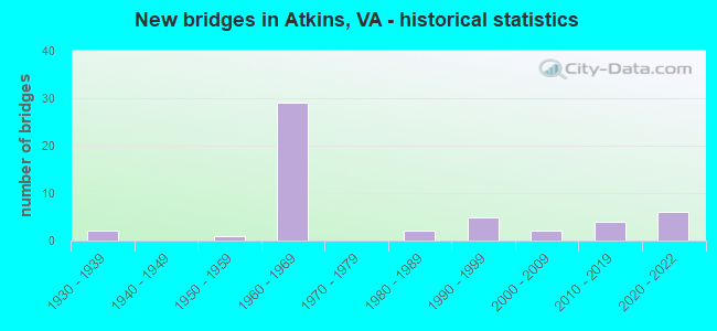
- New bridges - historical statistics
- 21930-1939
- 11950-1959
- 291960-1969
- 21980-1989
- 51990-1999
- 22000-2009
- 42010-2019
- 62020-2022
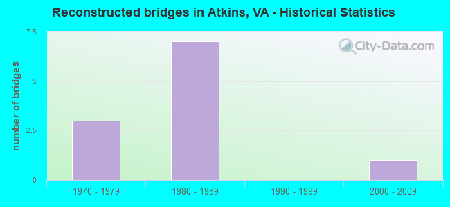
- Reconstructed bridges - Historical Statistics
- 31970-1979
- 71980-1989
- 01990-1999
- 12000-2009
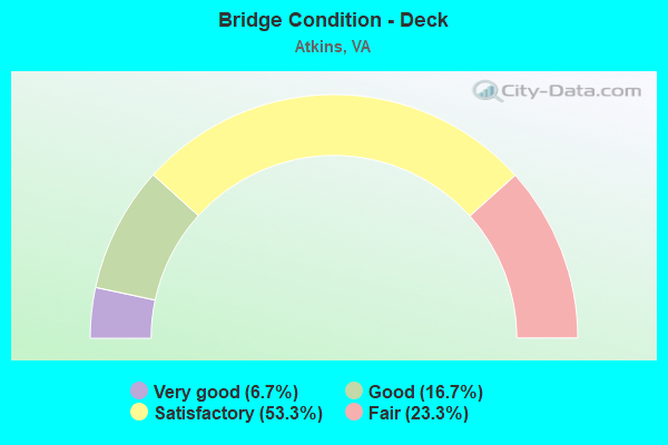
- Bridge Condition - Deck
- 6.7%Very good
- 16.7%Good
- 53.3%Satisfactory
- 23.3%Fair
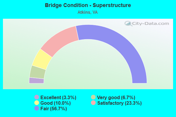
- Bridge Condition - Superstructure
- 3.3%Excellent
- 6.7%Very good
- 10.0%Good
- 23.3%Satisfactory
- 56.7%Fair
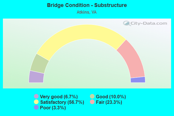
- Bridge Condition - Substructure
- 6.7%Very good
- 10.0%Good
- 56.7%Satisfactory
- 23.3%Fair
- 3.3%Poor

- Bridge Condition - Channel
- 13.0%Very good
- 4.3%Good
- 39.1%Satisfactory
- 43.5%Fair

- Bridge Condition - Culverts
- 16.7%Good
- 33.3%Satisfactory
- 50.0%Fair
Find on map >> Show street view
Structure Number: 17363, Location: 0.01 FR 622 - 1.09 TO 686 (Lat: 36.861500, Lng: -81.432925), Route carried "on" structure: ServiceCounty highway F011, Year Built: 1990, Status: Open, Structure Length: 0.98m (3.22ft), Average Daily Traffic: 3,834 (year 2018), Average Future Daily Traffic: 5,304 (year 2040), Design Load: HS 20+Mod, Features Intersected: NICKS CREEK, Facility Carried by Structure: Gordondale Rd.
Minimum Vertical Clearance: 30+ m (98+ ft), Kilometerpoint: 0.064, Lanes on structure: 2, Owner: State Highway Agency, Approaching Roadway Width: 7.6m (24.9ft), Material/Design: Concrete, Design/Construction: Slab, Number Of Spans In Main Unit: 1, Length of Maximum Span: 9.0m (29.5ft), Curb-To-Curb Width: 9.4m (30.8ft), Out-to-Out Width: 10.4m (34.1ft)
Condition: Deck: Satisfactory, Superstructure: Satisfactory, Substructure: Satisfactory, Channel: Fair, Operating Rating: 89.8 metric tons, Method Used To Determine Operating Rating: Load and Resistance Factor (LRFR), Inventory Rating: 84.4 metric tons, Method Used To Determine Inventory Rating: Load and Resistance Factor (LRFR), Structural Evaluation: Equal to present minimum criteria, Deck Geometry: Meets minimum limits, Waterway Adequacy: Better than present minimum criteria, Approach Roadway Alignment: Better than present minimum criteria, Length Of Structure Improvement: 0.98m (3.22ft), Designated Inspection Frequency: Every 24 months, Inspection Date: Febuary 2022, Bridge Improvement Cost: $163,000, Roadway Improvement Cost: $50,000, Total Project Cost: $277,000 ( Estimate for 2014), Deck Structure Type: Concrete Cast-file-Place, Wearing Surface/Protective System: Wearing Surface: Monolithic Concrete
Find on map >> Show street view
Structure Number: 17367, Location: 4.0 FR 683 - .01 TO 622 (Lat: 36.864858, Lng: -81.435533), Route carried "on" structure: US 11, Year Built: 1990, Status: Open, Structure Length: 0.98m (3.22ft), Average Daily Traffic: 2,650 (year 2020), Truck Traffic: 3%, Average Future Daily Traffic: 2,915 (year 2040), Design Load: HS 20+Mod, Features Intersected: NICK CREEK @ ATKINS, Facility Carried by Structure: LEE HIGHWAY
Minimum Vertical Clearance: 30+ m (98+ ft), Kilometerpoint: 80.215, Lanes on structure: 2, Base Highway Network: Yes, Owner: State Highway Agency, Approaching Roadway Width: 7.3m (24.0ft), Material/Design: Concrete, Design/Construction: Slab, Number Of Spans In Main Unit: 1, Length of Maximum Span: 9.1m (29.9ft), Curb-To-Curb Width: 14.2m (46.6ft), Out-to-Out Width: 16.5m (54.1ft)
Condition: Deck: Fair, Superstructure: Fair, Substructure: Fair, Channel: Satisfactory, Operating Rating: 89.8 metric tons, Method Used To Determine Operating Rating: Load and Resistance Factor (LRFR), Inventory Rating: 88.9 metric tons, Method Used To Determine Inventory Rating: Load and Resistance Factor (LRFR), Structural Evaluation: Somewhat better than minimum adequacy, Deck Geometry: Superior to present desirable criteria, Waterway Adequacy: Better than present minimum criteria, Approach Roadway Alignment: Better than present minimum criteria, Designated Inspection Frequency: Every 24 months, Inspection Date: Febuary 2022, Deck Structure Type: Concrete Cast-file-Place
Find on map >> Show street view
Structure Number: 17377, Location: .14 FR 753 - .02 TO 689 (Lat: 36.855758, Lng: -81.469236), Route carried "on" structure: US 11, Year Built: 1950, Status: Open, Structure Length: 0.94m (3.08ft), Average Daily Traffic: 4,308 (year 2020), Truck Traffic: 3%, Average Future Daily Traffic: 4,739 (year 2040), Design Load: HS 20, Features Intersected: HUTTON CREEK, Facility Carried by Structure: LEE HIGHWAY
Minimum Vertical Clearance: 30+ m (98+ ft), Kilometerpoint: 77.015, Lanes on structure: 2, Owner: State Highway Agency, Approaching Roadway Width: 6.7m (22.0ft), Material/Design: Concrete, Design/Construction: Culvert, Number Of Spans In Main Unit: 3, Length of Maximum Span: 3.0m (9.8ft)
Condition: Channel: Fair, Culverts: Satisfactory, Operating Rating: 44.5 metric tons, Method Used To Determine Operating Rating: Field evaluation and documented engineering judgment, Inventory Rating: 32.7 metric tons, Method Used To Determine Inventory Rating: Field evaluation and documented engineering judgment, Structural Evaluation: Equal to present minimum criteria, Waterway Adequacy: Better than present minimum criteria, Approach Roadway Alignment: Better than present minimum criteria, Designated Inspection Frequency: Every 24 months, Inspection Date: Febuary 2022
Find on map >> Show street view
Structure Number: 1744, Location: 1.77 TO R11 &4.28 TO R683 (Lat: 36.858706, Lng: -81.456036), Route carried "on" structure: Interstate 81, Year Built: 1963, Year Reconstructed: 1987, Status: Open, Structure Length: 4.67m (15.32ft), Average Daily Traffic: 12,802 (year 2020), Truck Traffic: 21%, Average Future Daily Traffic: 17,923 (year 2040), Design Load: HS 20, Features Intersected: ROUTE 690
Minimum Vertical Clearance: 30+ m (98+ ft), Kilometerpoint: 80.563, Lanes on structure: 2, Lanes under structure: 2, Base Highway Network: Yes, Owner: State Highway Agency, Approaching Roadway Width: 12.8m (42.0ft), Material/Design: Steel continuous, Design/Construction: Stringer/Multi-beam, Number Of Spans In Main Unit: 3, Length of Maximum Span: 17.4m (57.1ft), Curb-To-Curb Width: 12.8m (42.0ft), Out-to-Out Width: 13.4m (44.0ft)
Condition: Deck: Fair, Superstructure: Fair, Substructure: Satisfactory, Operating Rating: 38.1 metric tons, Method Used To Determine Operating Rating: Load and Resistance Factor (LRFR), Inventory Rating: 29.0 metric tons, Method Used To Determine Inventory Rating: Load and Resistance Factor (LRFR), Structural Evaluation: Somewhat better than minimum adequacy, Deck Geometry: Equal to present desirable criteria, Underclear: Somewhat better than minimum adequacy, Approach Roadway Alignment: Better than present minimum criteria, Length Of Structure Improvement: 4.66m (15.29ft), Designated Inspection Frequency: Every 24 months, Inspection Date: April 2020, Bridge Improvement Cost: $135,000, Roadway Improvement Cost: $10,000, Total Project Cost: $189,000, Deck Structure Type: Concrete Cast-file-Place, Wearing Surface/Protective System: Wearing Surface: Epoxy Overlay
Find on map >> Show street view
Structure Number: 17442, Location: 1.77 TO R11&4.28 TO R683 (Lat: 36.858486, Lng: -81.455950), Route carried "on" structure: Interstate 81, Year Built: 1963, Year Reconstructed: 1991, Status: Open, Structure Length: 4.67m (15.32ft), Average Daily Traffic: 13,904 (year 2020), Truck Traffic: 21%, Average Future Daily Traffic: 19,466 (year 2040), Design Load: HS 20+Mod, Features Intersected: ROUTE 690
Minimum Vertical Clearance: 30+ m (98+ ft), Kilometerpoint: 80.048, Lanes on structure: 2, Lanes under structure: 2, Base Highway Network: Yes, Owner: State Highway Agency, Approaching Roadway Width: 12.8m (42.0ft), Material/Design: Steel, Design/Construction: Stringer/Multi-beam, Number Of Spans In Main Unit: 3, Length of Maximum Span: 17.4m (57.1ft), Curb-To-Curb Width: 12.8m (42.0ft), Out-to-Out Width: 13.4m (44.0ft)
Condition: Deck: Satisfactory, Superstructure: Fair, Substructure: Satisfactory, Operating Rating: 51.7 metric tons, Method Used To Determine Operating Rating: Load and Resistance Factor (LRFR), Inventory Rating: 39.9 metric tons, Method Used To Determine Inventory Rating: Load and Resistance Factor (LRFR), Structural Evaluation: Somewhat better than minimum adequacy, Deck Geometry: Equal to present desirable criteria, Underclear: Somewhat better than minimum adequacy, Approach Roadway Alignment: Better than present minimum criteria, Designated Inspection Frequency: Every 24 months, Inspection Date: April 2020, Deck Structure Type: Concrete Cast-file-Place, Wearing Surface/Protective System: Wearing Surface: Epoxy Overlay
Find on map >> Show street view
Structure Number: 17444, Location: 1.04 TO R11&6.01 TO R683 (Lat: 36.853700, Lng: -81.467589), Route carried "on" structure: Interstate 81, Year Built: 1963, Year Reconstructed: 1991, Status: Open, Structure Length: 5.00m (16.40ft), Average Daily Traffic: 12,802 (year 2020), Truck Traffic: 21%, Average Future Daily Traffic: 17,923 (year 2040), Design Load: HS 20+Mod, Features Intersected: Hutton Branch Rd.
Minimum Vertical Clearance: 30+ m (98+ ft), Kilometerpoint: 79.372, Lanes on structure: 2, Lanes under structure: 2, Base Highway Network: Yes, Owner: State Highway Agency, Approaching Roadway Width: 14.9m (48.9ft), Material/Design: Steel, Design/Construction: Stringer/Multi-beam, Number Of Spans In Main Unit: 3, Length of Maximum Span: 18.9m (62.0ft), Curb-To-Curb Width: 12.8m (42.0ft), Out-to-Out Width: 13.4m (44.0ft)
Condition: Deck: Satisfactory, Superstructure: Fair, Substructure: Satisfactory, Operating Rating: 49.0 metric tons, Method Used To Determine Operating Rating: Load and Resistance Factor (LRFR), Inventory Rating: 38.1 metric tons, Method Used To Determine Inventory Rating: Load and Resistance Factor (LRFR), Structural Evaluation: Somewhat better than minimum adequacy, Deck Geometry: Equal to present desirable criteria, Underclear: Meets minimum limits, Approach Roadway Alignment: Better than present minimum criteria, Designated Inspection Frequency: Every 24 months, Inspection Date: Febuary 2020, Deck Structure Type: Concrete Cast-file-Place, Wearing Surface/Protective System: Wearing Surface: Latex Concrete, Membrane: Built-up, Deck Protection: Other
Find on map >> Show street view
Structure Number: 17446, Location: 1.04 TO R11&6.01 TO R683 (Lat: 36.853528, Lng: -81.467414), Route carried "on" structure: Interstate 81, Year Built: 1963, Year Reconstructed: 1991, Status: Open, Structure Length: 4.52m (14.83ft), Average Daily Traffic: 13,904 (year 2020), Truck Traffic: 21%, Average Future Daily Traffic: 19,466 (year 2040), Design Load: HS 20+Mod, Features Intersected: Route 689
Minimum Vertical Clearance: 30+ m (98+ ft), Kilometerpoint: 78.857, Lanes on structure: 2, Lanes under structure: 2, Base Highway Network: Yes, Owner: State Highway Agency, Approaching Roadway Width: 14.9m (48.9ft), Material/Design: Steel, Design/Construction: Stringer/Multi-beam, Number Of Spans In Main Unit: 3, Length of Maximum Span: 16.5m (54.1ft), Curb-To-Curb Width: 12.8m (42.0ft), Out-to-Out Width: 13.4m (44.0ft)
Condition: Deck: Satisfactory, Superstructure: Fair, Substructure: Fair, Operating Rating: 49.9 metric tons, Method Used To Determine Operating Rating: Load and Resistance Factor (LRFR), Inventory Rating: 39.0 metric tons, Method Used To Determine Inventory Rating: Load and Resistance Factor (LRFR), Structural Evaluation: Somewhat better than minimum adequacy, Deck Geometry: Equal to present desirable criteria, Underclear: Meets minimum limits, Approach Roadway Alignment: Better than present minimum criteria, Length Of Structure Improvement: 4.51m (14.80ft), Designated Inspection Frequency: Every 24 months, Inspection Date: Febuary 2020, Bridge Improvement Cost: $100,000, Total Project Cost: $130,000 ( Estimate for 2014), Deck Structure Type: Concrete Cast-file-Place
Find on map >> Show street view
Structure Number: 17456, Location: .16 FR I-81SBL-.01 TO 622 (Lat: 36.864050, Lng: -81.434833), Route carried "on" structure: Ramp Interstate 81, Year Built: 1990, Status: Open, Structure Length: 0.98m (3.22ft), Average Daily Traffic: 631 (year 2020), Average Future Daily Traffic: 694 (year 2040), Design Load: HS 20, Features Intersected: SBL RAMP C OV NICKS CR
Minimum Vertical Clearance: 30+ m (98+ ft), Kilometerpoint: 82.316, Lanes on structure: 2, Base Highway Network: Yes, Owner: State Highway Agency, Approaching Roadway Width: 5.5m (18.0ft), Material/Design: Concrete, Design/Construction: Slab, Number Of Spans In Main Unit: 1, Length of Maximum Span: 9.1m (29.9ft), Curb-To-Curb Width: 10.3m (33.8ft), Out-to-Out Width: 11.3m (37.1ft)
Condition: Deck: Fair, Superstructure: Fair, Substructure: Fair, Channel: Satisfactory, Operating Rating: 89.8 metric tons, Method Used To Determine Operating Rating: Load and Resistance Factor (LRFR), Inventory Rating: 88.9 metric tons, Method Used To Determine Inventory Rating: Load and Resistance Factor (LRFR), Structural Evaluation: Somewhat better than minimum adequacy, Deck Geometry: Equal to present minimum criteria, Waterway Adequacy: Better than present minimum criteria, Approach Roadway Alignment: Better than present minimum criteria, Designated Inspection Frequency: Every 24 months, Inspection Date: Febuary 2022, Deck Structure Type: Concrete Cast-file-Place
Find on map >> Show street view
Structure Number: 17457, Location: .01 FR 622-.16 TO I-81NBL (Lat: 36.862167, Lng: -81.433453), Route carried "on" structure: Ramp Interstate 81, Year Built: 1990, Status: Open, Structure Length: 0.98m (3.22ft), Average Daily Traffic: 355 (year 2020), Average Future Daily Traffic: 498 (year 2040), Design Load: HS 20, Features Intersected: NBL RAMP D OV NICKS CR
Minimum Vertical Clearance: 30+ m (98+ ft), Kilometerpoint: 82.316, Lanes on structure: 1, Base Highway Network: Yes, Owner: State Highway Agency, Approaching Roadway Width: 6.7m (22.0ft), Material/Design: Concrete, Design/Construction: Slab, Number Of Spans In Main Unit: 1, Length of Maximum Span: 9.1m (29.9ft), Curb-To-Curb Width: 10.3m (33.8ft), Out-to-Out Width: 11.3m (37.1ft)
Condition: Deck: Fair, Superstructure: Fair, Substructure: Fair, Channel: Fair, Operating Rating: 89.8 metric tons, Method Used To Determine Operating Rating: Load and Resistance Factor (LRFR), Inventory Rating: 88.9 metric tons, Method Used To Determine Inventory Rating: Load and Resistance Factor (LRFR), Structural Evaluation: Somewhat better than minimum adequacy, Deck Geometry: Superior to present desirable criteria, Waterway Adequacy: Better than present minimum criteria, Approach Roadway Alignment: Better than present minimum criteria, Designated Inspection Frequency: Every 24 months, Inspection Date: Febuary 2022, Deck Structure Type: Concrete Cast-file-Place
Find on map >> Show street view
Structure Number: 1746, Location: 3.03 TO R11 & 4.0 TO R683 (Lat: 36.863150, Lng: -81.434653), Route carried "on" structure: Interstate 81, Year Built: 1963, Year Reconstructed: 1989, Status: Open, Structure Length: 6.21m (20.37ft), Average Daily Traffic: 12,802 (year 2020), Truck Traffic: 21%, Average Future Daily Traffic: 17,923 (year 2040), Design Load: HS 20+Mod, Features Intersected: RT 622 AND NICKS CREEK
Minimum Vertical Clearance: 30+ m (98+ ft), Kilometerpoint: 82.619, Lanes on structure: 2, Lanes under structure: 2, Base Highway Network: Yes, Owner: State Highway Agency, Approaching Roadway Width: 14.9m (48.9ft), Skew: 2 degrees, Material/Design: Concrete, Design/Construction: Tee Beam, Number Of Spans In Main Unit: 5, Length of Maximum Span: 12.6m (41.3ft), Curb-To-Curb Width: 12.4m (40.7ft), Out-to-Out Width: 13.4m (44.0ft)
Condition: Deck: Satisfactory, Superstructure: Fair, Substructure: Satisfactory, Channel: Good, Operating Rating: 70.8 metric tons, Method Used To Determine Operating Rating: Load and Resistance Factor (LRFR), Inventory Rating: 54.4 metric tons, Method Used To Determine Inventory Rating: Load and Resistance Factor (LRFR), Structural Evaluation: Somewhat better than minimum adequacy, Deck Geometry: Better than present minimum criteria, Waterway Adequacy: Better than present minimum criteria, Approach Roadway Alignment: Better than present minimum criteria, Length Of Structure Improvement: 6.22m (20.41ft), Designated Inspection Frequency: Every 24 months, Inspection Date: March 2020, Bridge Improvement Cost: $625,000, Roadway Improvement Cost: $20,000, Total Project Cost: $839,000, Deck Structure Type: Concrete Cast-file-Place, Wearing Surface/Protective System: Wearing Surface: Epoxy Overlay, Membrane: Built-up, Deck Protection: Other
Find on map >> Show street view
Structure Number: 17462, Location: 4.5 TO R11 & 2.55 TO R683 (Lat: 36.868553, Lng: -81.408939), Route carried "on" structure: Interstate 81, Year Built: 1963, Year Reconstructed: 1982, Status: Open, Structure Length: 3.38m (11.09ft), Average Daily Traffic: 13,068 (year 2020), Truck Traffic: 21%, Average Future Daily Traffic: 18,295 (year 2040), Design Load: HS 20+Mod, Features Intersected: KIAWANA ROAD
Minimum Vertical Clearance: 30+ m (98+ ft), Kilometerpoint: 84.506, Lanes on structure: 2, Lanes under structure: 2, Base Highway Network: Yes, Owner: State Highway Agency, Approaching Roadway Width: 14.9m (48.9ft), Material/Design: Concrete, Design/Construction: Tee Beam, Number Of Spans In Main Unit: 3, Length of Maximum Span: 11.9m (39.0ft), Curb-To-Curb Width: 12.8m (42.0ft), Out-to-Out Width: 13.4m (44.0ft)
Condition: Deck: Satisfactory, Superstructure: Fair, Substructure: Satisfactory, Operating Rating: 64.4 metric tons, Method Used To Determine Operating Rating: Load and Resistance Factor (LRFR), Inventory Rating: 49.9 metric tons, Method Used To Determine Inventory Rating: Load and Resistance Factor (LRFR), Structural Evaluation: Somewhat better than minimum adequacy, Deck Geometry: Equal to present desirable criteria, Underclear: Somewhat better than minimum adequacy, Approach Roadway Alignment: Better than present minimum criteria, Length Of Structure Improvement: 3.38m (11.09ft), Designated Inspection Frequency: Every 24 months, Inspection Date: January 2022, Bridge Improvement Cost: $85,000, Roadway Improvement Cost: $20,000, Total Project Cost: $137,000 ( Estimate for 2019), Deck Structure Type: Concrete Cast-file-Place, Wearing Surface/Protective System: Wearing Surface: Epoxy Overlay
Find on map >> Show street view
Structure Number: 17464, Location: 1.5 FR R622 -2.55 TO R683 (Lat: 36.868761, Lng: -81.409039), Route carried "on" structure: Interstate 81, Year Built: 1963, Year Reconstructed: 1987, Status: Open, Structure Length: 3.38m (11.09ft), Average Daily Traffic: 10,889 (year 2020), Truck Traffic: 21%, Average Future Daily Traffic: 15,245 (year 2040), Design Load: HS 20+Mod, Features Intersected: KIAWANA ROAD
Minimum Vertical Clearance: 30+ m (98+ ft), Kilometerpoint: 84.989, Lanes on structure: 2, Lanes under structure: 2, Base Highway Network: Yes, Owner: State Highway Agency, Approaching Roadway Width: 14.9m (48.9ft), Material/Design: Concrete, Design/Construction: Tee Beam, Number Of Spans In Main Unit: 3, Length of Maximum Span: 11.9m (39.0ft), Curb-To-Curb Width: 12.8m (42.0ft), Out-to-Out Width: 13.4m (44.0ft)
Condition: Deck: Satisfactory, Superstructure: Fair, Substructure: Satisfactory, Operating Rating: 64.4 metric tons, Method Used To Determine Operating Rating: Load and Resistance Factor (LRFR), Inventory Rating: 49.9 metric tons, Method Used To Determine Inventory Rating: Load and Resistance Factor (LRFR), Structural Evaluation: Somewhat better than minimum adequacy, Deck Geometry: Equal to present desirable criteria, Underclear: Meets minimum limits, Approach Roadway Alignment: Better than present minimum criteria, Length Of Structure Improvement: 3.38m (11.09ft), Designated Inspection Frequency: Every 24 months, Inspection Date: January 2022, Bridge Improvement Cost: $90,000, Roadway Improvement Cost: $15,000, Total Project Cost: $137,000 ( Estimate for 2014), Deck Structure Type: Concrete Cast-file-Place, Wearing Surface/Protective System: Wearing Surface: Epoxy Overlay
Find on map >> Show street view
Structure Number: 17474, Location: 7.05 TO R11 & 2.61 WYTHE (Lat: 36.888278, Lng: -81.371575), Route carried "on" structure: Interstate 81, Year Built: 1964, Year Reconstructed: 1982, Status: Open, Structure Length: 3.62m (11.88ft), Average Daily Traffic: 11,120 (year 2020), Truck Traffic: 21%, Average Future Daily Traffic: 15,568 (year 2040), Design Load: HS 20, Features Intersected: Route 683
Minimum Vertical Clearance: 30+ m (98+ ft), Kilometerpoint: 88.575, Lanes on structure: 2, Lanes under structure: 2, Base Highway Network: Yes, Owner: State Highway Agency, Approaching Roadway Width: 14.9m (48.9ft), Skew: 2 degrees, Material/Design: Concrete, Design/Construction: Tee Beam, Number Of Spans In Main Unit: 3, Length of Maximum Span: 14.3m (46.9ft), Curb-To-Curb Width: 12.8m (42.0ft), Out-to-Out Width: 13.4m (44.0ft)
Condition: Deck: Fair, Superstructure: Fair, Substructure: Satisfactory, Operating Rating: 57.2 metric tons, Method Used To Determine Operating Rating: Load and Resistance Factor (LRFR), Inventory Rating: 44.5 metric tons, Method Used To Determine Inventory Rating: Load and Resistance Factor (LRFR), Structural Evaluation: Somewhat better than minimum adequacy, Deck Geometry: Equal to present desirable criteria, Underclear: High priority of corrective action, Approach Roadway Alignment: Better than present minimum criteria, Length Of Structure Improvement: 3.63m (11.91ft), Designated Inspection Frequency: Every 24 months, Inspection Date: March 2020, Bridge Improvement Cost: $93,000, Roadway Improvement Cost: $20,000, Total Project Cost: $147,000, Deck Structure Type: Concrete Cast-file-Place, Wearing Surface/Protective System: Wearing Surface: Latex Concrete
Find on map >> Show street view
Structure Number: 17476, Location: 7.05 TO R11&2.6 TO WYTH L (Lat: 36.888644, Lng: -81.371589), Route carried "on" structure: Interstate 81, Year Built: 1964, Year Reconstructed: 1982, Status: Open, Structure Length: 3.62m (11.88ft), Average Daily Traffic: 10,889 (year 2020), Truck Traffic: 21%, Average Future Daily Traffic: 15,245 (year 2040), Design Load: HS 20+Mod, Features Intersected: ROUTE 683
Minimum Vertical Clearance: 30+ m (98+ ft), Kilometerpoint: 89.010, Lanes on structure: 2, Lanes under structure: 2, Base Highway Network: Yes, Owner: State Highway Agency, Approaching Roadway Width: 14.9m (48.9ft), Skew: 2 degrees, Material/Design: Concrete, Design/Construction: Tee Beam, Number Of Spans In Main Unit: 3, Length of Maximum Span: 14.3m (46.9ft), Curb-To-Curb Width: 12.8m (42.0ft), Out-to-Out Width: 13.4m (44.0ft)
Condition: Deck: Satisfactory, Superstructure: Fair, Substructure: Satisfactory, Operating Rating: 59.0 metric tons, Method Used To Determine Operating Rating: Load and Resistance Factor (LRFR), Inventory Rating: 45.4 metric tons, Method Used To Determine Inventory Rating: Load and Resistance Factor (LRFR), Structural Evaluation: Somewhat better than minimum adequacy, Deck Geometry: Equal to present desirable criteria, Underclear: High priority of corrective action, Approach Roadway Alignment: Better than present minimum criteria, Length Of Structure Improvement: 3.63m (11.91ft), Designated Inspection Frequency: Every 24 months, Inspection Date: March 2020, Bridge Improvement Cost: $100,000, Roadway Improvement Cost: $13,000, Total Project Cost: $147,000, Deck Structure Type: Concrete Cast-file-Place, Wearing Surface/Protective System: Wearing Surface: Latex Concrete, Membrane: Built-up, Deck Protection: Other
Find on map >> Show street view
Structure Number: 1748, Location: 5.21 TO R11 &1.84 TO R683 (Lat: 36.874189, Lng: -81.399150), Route carried "on" structure: Interstate 81, Year Built: 1964, Year Reconstructed: 1985, Status: Open, Structure Length: 15.27m (50.10ft), Average Daily Traffic: 10,889 (year 2020), Truck Traffic: 21%, Average Future Daily Traffic: 15,245 (year 2040), Design Load: HS 20+Mod, Features Intersected: RT11;NS RR;M.F.HOLSTON R
Minimum Vertical Clearance: 30+ m (98+ ft), Kilometerpoint: 86.217, Lanes on structure: 2, Lanes under structure: 2, Base Highway Network: Yes, Owner: State Highway Agency, Approaching Roadway Width: 11.0m (36.1ft), Skew: 4 degrees, Material/Design: Steel, Design/Construction: Stringer/Multi-beam, Number Of Spans In Main Unit: 7, Length of Maximum Span: 25.3m (83.0ft), Curb or Sidewalk Widths: Left: 0.5m (1.6ft), Right: 0.8m (2.6ft), Curb-To-Curb Width: 8.8m (28.9ft), Out-to-Out Width: 10.7m (35.1ft)
Condition: Deck: Fair, Superstructure: Fair, Substructure: Fair, Channel: Very good, Operating Rating: 64.4 metric tons, Method Used To Determine Operating Rating: Load and Resistance Factor (LRFR), Inventory Rating: 49.9 metric tons, Method Used To Determine Inventory Rating: Load and Resistance Factor (LRFR), Structural Evaluation: Somewhat better than minimum adequacy, Deck Geometry: Meets minimum limits, Underclear: Better than present minimum criteria, Waterway Adequacy: Better than present minimum criteria, Approach Roadway Alignment: Better than present minimum criteria, Length Of Structure Improvement: 15.27m (50.10ft), Designated Inspection Frequency: Every 24 months, Inspection Date: April 2020, Bridge Improvement Cost: $60,000, Roadway Improvement Cost: $21,000, Total Project Cost: $105,000, Deck Structure Type: Concrete Cast-file-Place, Wearing Surface/Protective System: Wearing Surface: Latex Concrete, Membrane: Built-up, Deck Protection: Other
Find on map >> Show street view
Structure Number: 1749, Location: 1.07FR 11 SPUR;5.98TO 683 (Lat: 36.853900, Lng: -81.466706), Route carried "on" structure: Interstate 81, Year Built: 1963, Status: Open, Structure Length: 0.76m (2.49ft), Average Daily Traffic: 26,706 (year 2020), Truck Traffic: 21%, Average Future Daily Traffic: 28,217 (year 2040), Design Load: HS 20, Features Intersected: N&SBL O HUTTON BRANCH
Minimum Vertical Clearance: 30+ m (98+ ft), Kilometerpoint: 79.292, Lanes on structure: 4, Base Highway Network: Yes, Owner: State Highway Agency, Approaching Roadway Width: 39.9m (130.9ft), Material/Design: Concrete, Design/Construction: Culvert, Number Of Spans In Main Unit: 3, Length of Maximum Span: 2.4m (7.9ft)
Condition: Channel: Satisfactory, Culverts: Fair, Operating Rating: 44.5 metric tons, Method Used To Determine Operating Rating: Field evaluation and documented engineering judgment, Inventory Rating: 32.7 metric tons, Method Used To Determine Inventory Rating: Field evaluation and documented engineering judgment, Structural Evaluation: Somewhat better than minimum adequacy, Waterway Adequacy: Equal to present minimum criteria, Approach Roadway Alignment: Better than present minimum criteria, Length Of Structure Improvement: 0.76m (2.49ft), Designated Inspection Frequency: Every 24 months, Inspection Date: January 2021, Bridge Improvement Cost: $40,000, Roadway Improvement Cost: $20,000, Total Project Cost: $78,000 ( Estimate for 2018)
Find on map >> Show street view
Structure Number: 17495, Location: 6.97 TO R11; .08 TO R683 (Lat: 36.888050, Lng: -81.372150), Route carried "on" structure: Interstate 81, Year Built: 1964, Status: Open, Structure Length: 0.88m (2.89ft), Average Daily Traffic: 21,600 (year 2020), Truck Traffic: 21%, Average Future Daily Traffic: 23,760 (year 2040), Design Load: HS 20, Features Intersected: NBL&SBL OVER STREAM
Minimum Vertical Clearance: 30+ m (98+ ft), Kilometerpoint: 88.785, Lanes on structure: 4, Base Highway Network: Yes, Owner: State Highway Agency, Approaching Roadway Width: 54.3m (178.1ft), Skew: 3 degrees, Material/Design: Concrete, Design/Construction: Culvert, Number Of Spans In Main Unit: 3, Length of Maximum Span: 2.7m (8.9ft)
Condition: Channel: Fair, Culverts: Fair, Operating Rating: 44.5 metric tons, Method Used To Determine Operating Rating: Field evaluation and documented engineering judgment, Inventory Rating: 32.7 metric tons, Method Used To Determine Inventory Rating: Field evaluation and documented engineering judgment, Structural Evaluation: Somewhat better than minimum adequacy, Waterway Adequacy: Better than present minimum criteria, Approach Roadway Alignment: Better than present minimum criteria, Length Of Structure Improvement: 0.88m (2.89ft), Designated Inspection Frequency: Every 24 months, Inspection Date: January 2021, Bridge Improvement Cost: $40,000, Roadway Improvement Cost: $20,000, Total Project Cost: $78,000 ( Estimate for 2018)
Find on map >> Show street view
Structure Number: 17496, Location: 6.97-RT11 & .08-RT683 (Lat: 36.889231, Lng: -81.372025), Route carried "on" structure: Ramp Interstate 81, Year Built: 1964, Status: Open, Structure Length: 0.88m (2.89ft), Average Daily Traffic: 292 (year 2020), Average Future Daily Traffic: 410 (year 2040), Design Load: HS 20, Features Intersected: RAMP TO SBL O STREAM
Minimum Vertical Clearance: 30+ m (98+ ft), Kilometerpoint: 88.785, Lanes on structure: 2, Base Highway Network: Yes, Owner: State Highway Agency, Approaching Roadway Width: 10.7m (35.1ft), Skew: 3 degrees, Material/Design: Concrete, Design/Construction: Culvert, Number Of Spans In Main Unit: 3, Length of Maximum Span: 2.7m (8.9ft)
Condition: Channel: Fair, Culverts: Satisfactory, Operating Rating: 44.5 metric tons, Method Used To Determine Operating Rating: Field evaluation and documented engineering judgment, Inventory Rating: 32.7 metric tons, Method Used To Determine Inventory Rating: Field evaluation and documented engineering judgment, Structural Evaluation: Equal to present minimum criteria, Waterway Adequacy: Better than present minimum criteria, Approach Roadway Alignment: Better than present minimum criteria, Designated Inspection Frequency: Every 24 months, Inspection Date: January 2021
Find on map >> Show street view
Structure Number: 17497, Location: .08 TO R683 & 6.97 11SPUR (Lat: 36.887486, Lng: -81.372322), Route carried "on" structure: Ramp Interstate 81, Year Built: 1964, Status: Open, Structure Length: 0.94m (3.08ft), Average Daily Traffic: 760 (year 2020), Average Future Daily Traffic: 994 (year 2040), Design Load: HS 20, Features Intersected: DRY CREEK
Minimum Vertical Clearance: 30+ m (98+ ft), Kilometerpoint: 88.752, Lanes on structure: 2, Base Highway Network: Yes, Owner: State Highway Agency, Approaching Roadway Width: 6.7m (22.0ft), Skew: 3 degrees, Material/Design: Concrete, Design/Construction: Culvert, Number Of Spans In Main Unit: 3, Length of Maximum Span: 3.0m (9.8ft)
Condition: Channel: Fair, Culverts: Fair, Operating Rating: 89.8 metric tons, Method Used To Determine Operating Rating: Field evaluation and documented engineering judgment, Inventory Rating: 88.9 metric tons, Method Used To Determine Inventory Rating: Field evaluation and documented engineering judgment, Structural Evaluation: Somewhat better than minimum adequacy, Waterway Adequacy: Better than present minimum criteria, Approach Roadway Alignment: Better than present minimum criteria, Length Of Structure Improvement: 0.94m (3.08ft), Designated Inspection Frequency: Every 24 months, Inspection Date: October 2021, Bridge Improvement Cost: $50,000, Roadway Improvement Cost: $10,000, Total Project Cost: $78,000 ( Estimate for 2015)
Find on map >> Show street view
Structure Number: 17566, Location: 1.15 FR 685; 0.05 TO 622 (Lat: 36.875422, Lng: -81.438872), Route carried "on" structure: County highway 617, Year Built: 2011, Status: Open, Structure Length: 1.06m (3.48ft), Average Daily Traffic: 130 (year 2017), Average Future Daily Traffic: 145 (year 2040), Design Load: HS 20, Features Intersected: BEAR CREEK, Facility Carried by Structure: Flowing Springs Rd
Minimum Vertical Clearance: 30+ m (98+ ft), Kilometerpoint: 28.576, Lanes on structure: 2, Owner: State Highway Agency, Approaching Roadway Width: 5.5m (18.0ft), Material/Design: Concrete, Design/Construction: Slab, Number Of Spans In Main Unit: 1, Length of Maximum Span: 9.6m (31.5ft), Curb-To-Curb Width: 5.9m (19.4ft), Out-to-Out Width: 6.4m (21.0ft)
Condition: Deck: Satisfactory, Superstructure: Satisfactory, Substructure: Satisfactory, Channel: Very good, Operating Rating: 60.8 metric tons, Method Used To Determine Operating Rating: Load and Resistance Factor (LRFR), Inventory Rating: 46.3 metric tons, Method Used To Determine Inventory Rating: Load and Resistance Factor (LRFR), Structural Evaluation: Equal to present minimum criteria, Deck Geometry: High priority of corrective action, Waterway Adequacy: Better than present minimum criteria, Approach Roadway Alignment: Better than present minimum criteria, Designated Inspection Frequency: Every 24 months, Inspection Date: March 2021, Deck Structure Type: Concrete Precast Panels, Wearing Surface/Protective System: Wearing Surface: Bituminous
Find on map >> Show street view
Structure Number: 1758, Location: .05 TO R617&.25 TO R778 (Lat: 36.869214, Lng: -81.442017), Route carried "on" structure: County highway 622, Year Built: 2011, Status: Open, Structure Length: 1.23m (4.04ft), Average Daily Traffic: 812 (year 2017), Average Future Daily Traffic: 897 (year 2040), Design Load: HS 20, Features Intersected: BEAR CREEK, Facility Carried by Structure: BEAR CREEK RD
Minimum Vertical Clearance: 30+ m (98+ ft), Kilometerpoint: 10.463, Lanes on structure: 2, Owner: State Highway Agency, Approaching Roadway Width: 5.6m (18.4ft), Skew: 3 degrees, Material/Design: Concrete, Design/Construction: Slab, Number Of Spans In Main Unit: 1, Length of Maximum Span: 11.7m (38.4ft), Curb-To-Curb Width: 7.0m (23.0ft), Out-to-Out Width: 7.5m (24.6ft)
Condition: Deck: Satisfactory, Superstructure: Satisfactory, Substructure: Satisfactory, Channel: Satisfactory, Operating Rating: 89.8 metric tons, Method Used To Determine Operating Rating: Load and Resistance Factor (LRFR), Inventory Rating: 68.9 metric tons, Method Used To Determine Inventory Rating: Load and Resistance Factor (LRFR), Structural Evaluation: Equal to present minimum criteria, Deck Geometry: Meets minimum limits, Waterway Adequacy: Better than present minimum criteria, Approach Roadway Alignment: Better than present minimum criteria, Designated Inspection Frequency: Every 24 months, Inspection Date: March 2021, Deck Structure Type: Concrete Precast Panels, Wearing Surface/Protective System: Wearing Surface: Bituminous
Find on map >> Show street view
Structure Number: 17581, Location: 0.05FR778;0.25TO617 (Lat: 36.866608, Lng: -81.441892), Route carried "on" structure: County highway 622, Year Built: 1982, Status: Open, Structure Length: 2.93m (9.61ft), Average Daily Traffic: 812 (year 2017), Average Future Daily Traffic: 897 (year 2040), Design Load: HS 20+Mod, Features Intersected: MID FORK HOLSTON RIVER, Facility Carried by Structure: Bear Creek Rd.
Minimum Vertical Clearance: 30+ m (98+ ft), Kilometerpoint: 10.124, Lanes on structure: 2, Owner: State Highway Agency, Approaching Roadway Width: 6.1m (20.0ft), Skew: 4 degrees, Material/Design: Concrete, Design/Construction: Slab, Number Of Spans In Main Unit: 3, Length of Maximum Span: 9.8m (32.2ft), Curb-To-Curb Width: 7.3m (24.0ft), Out-to-Out Width: 7.9m (25.9ft)
Condition: Deck: Fair, Superstructure: Fair, Substructure: Fair, Channel: Satisfactory, Operating Rating: 89.8 metric tons, Method Used To Determine Operating Rating: Load and Resistance Factor (LRFR), Inventory Rating: 88.9 metric tons, Method Used To Determine Inventory Rating: Load and Resistance Factor (LRFR), Structural Evaluation: Somewhat better than minimum adequacy, Deck Geometry: Meets minimum limits, Waterway Adequacy: Better than present minimum criteria, Approach Roadway Alignment: Better than present minimum criteria, Length Of Structure Improvement: 2.93m (9.61ft), Designated Inspection Frequency: Every 12 months, Inspection Date: January 2022, Bridge Improvement Cost: $150,000, Roadway Improvement Cost: $20,000, Total Project Cost: $221,000, Deck Structure Type: Concrete Cast-file-Place
Find on map >> Show street view
Structure Number: 17588, Location: AT R11 & .9 TO R617 (Lat: 36.862608, Lng: -81.448825), Route carried "on" structure: County highway 622, Year Built: 1969, Status: Open, Structure Length: 3.73m (12.24ft), Average Daily Traffic: 1,982 (year 2017), Average Future Daily Traffic: 2,210 (year 2040), Design Load: HS 20+Mod, Features Intersected: NS RAILWAY, Facility Carried by Structure: BEAR CREEK ROAD
Minimum Vertical Clearance: 30+ m (98+ ft), Kilometerpoint: 8.989, Lanes on structure: 2, Owner: State Highway Agency, Approaching Roadway Width: 6.1m (20.0ft), Skew: 1 degrees, Material/Design: Steel, Design/Construction: Stringer/Multi-beam, Number Of Spans In Main Unit: 3, Length of Maximum Span: 12.2m (40.0ft), Curb-To-Curb Width: 7.9m (25.9ft), Out-to-Out Width: 9.1m (29.9ft)
Condition: Deck: Satisfactory, Superstructure: Fair, Substructure: Poor, Operating Rating: 62.6 metric tons, Method Used To Determine Operating Rating: Load and Resistance Factor (LRFR), Inventory Rating: 48.1 metric tons, Method Used To Determine Inventory Rating: Load and Resistance Factor (LRFR), Structural Evaluation: Meets minimum limits, Deck Geometry: Meets minimum limits, Underclear: Equal to present minimum criteria, Approach Roadway Alignment: Better than present minimum criteria, Designated Inspection Frequency: Every 24 months, Other Special Inspection Frequency: Every 12 months, Inspection Date: March 2021, Other Special Inspection Date: March 2021, Deck Structure Type: Concrete Cast-file-Place, Wearing Surface/Protective System: Wearing Surface: Monolithic Concrete
Find on map >> Show street view
Structure Number: 17592, Location: 0.15FR 11;0.25TO END MAIN (Lat: 36.869800, Lng: -81.416822), Route carried "on" structure: County highway 626, Year Built: 1932, Status: Posted for load, Structure Length: 1.01m (3.31ft), Average Daily Traffic: 40 (year 2017), Average Future Daily Traffic: 45 (year 2040), Design Load: H 15, Features Intersected: M FORK HOLSTON RIVER, Facility Carried by Structure: OLE HICKORY LN.
Minimum Vertical Clearance: 30+ m (98+ ft), Kilometerpoint: 0.241, Lanes on structure: 1, Owner: State Highway Agency, Approaching Roadway Width: 4.3m (14.1ft), Material/Design: Steel, Design/Construction: Stringer/Multi-beam, Number Of Spans In Main Unit: 1, Length of Maximum Span: 9.1m (29.9ft), Curb or Sidewalk Widths: Left: 0.2m (0.7ft), Right: 0.2m (0.7ft), Curb-To-Curb Width: 3.4m (11.2ft), Out-to-Out Width: 3.7m (12.1ft)
Condition: Deck: Good, Superstructure: Satisfactory, Substructure: Fair, Channel: Fair, Operating Rating: 24.5 metric tons, Method Used To Determine Operating Rating: Load Factor (LF), Inventory Rating: 14.5 metric tons, Method Used To Determine Inventory Rating: Load Factor (LF), Structural Evaluation: Meets minimum limits, Deck Geometry: High priority of corrective action, Waterway Adequacy: Better than present minimum criteria, Approach Roadway Alignment: Better than present minimum criteria, Bridge Posting: Required (Relationship of Operating Rating to Maximum Legal Load: 30.0 - 39.9% below), Length Of Structure Improvement: 1.01m (3.31ft), Designated Inspection Frequency: Every 24 months, Inspection Date: November 2020, Bridge Improvement Cost: $40,000, Roadway Improvement Cost: $25,000, Total Project Cost: $85,000 ( Estimate for 2015), Deck Structure Type: Wood or Timber, Wearing Surface/Protective System: Wearing Surface: Bituminous
Find on map >> Show street view
Structure Number: 17675, Location: .02 TO F014 & .13 TO R11 (Lat: 36.897883, Lng: -81.339019), Route carried "on" structure: County highway 681, Year Built: 1964, Status: Open, Structure Length: 6.19m (20.31ft), Average Daily Traffic: 255 (year 2017), Average Future Daily Traffic: 284 (year 2040), Design Load: HS 20, Features Intersected: INTERSTATE 81, Facility Carried by Structure: BURGUNDY LANE
Minimum Vertical Clearance: 30+ m (98+ ft), Kilometerpoint: 0.209, Lanes on structure: 2, Lanes under structure: 4, Owner: State Highway Agency, Approaching Roadway Width: 5.5m (18.0ft), Material/Design: Steel, Design/Construction: Stringer/Multi-beam, Number Of Spans In Main Unit: 4, Length of Maximum Span: 18.1m (59.4ft), Curb or Sidewalk Widths: Left: 0.5m (1.6ft), Right: 0.5m (1.6ft), Curb-To-Curb Width: 7.3m (24.0ft), Out-to-Out Width: 8.8m (28.9ft)
Condition: Deck: Satisfactory, Superstructure: Fair, Substructure: Satisfactory, Operating Rating: 53.5 metric tons, Method Used To Determine Operating Rating: Load and Resistance Factor (LRFR), Inventory Rating: 40.8 metric tons, Method Used To Determine Inventory Rating: Load and Resistance Factor (LRFR), Structural Evaluation: Somewhat better than minimum adequacy, Deck Geometry: Somewhat better than minimum adequacy, Underclear: Somewhat better than minimum adequacy, Approach Roadway Alignment: Better than present minimum criteria, Length Of Structure Improvement: 6.19m (20.31ft), Designated Inspection Frequency: Every 24 months, Inspection Date: Febuary 2022, Bridge Improvement Cost: $383,000, Roadway Improvement Cost: $30,000, Total Project Cost: $537,000 ( Estimate for 2019), Deck Structure Type: Concrete Cast-file-Place, Wearing Surface/Protective System: Wearing Surface: Latex Concrete
Find on map >> Show street view
Structure Number: 17678, Location: .4 TO R11 & .3 TO R617 (Lat: 36.892100, Lng: -81.370431), Route carried "on" structure: County highway 683, Year Built: 1986, Status: Open, Structure Length: 1.34m (4.40ft), Average Daily Traffic: 328 (year 2020), Average Future Daily Traffic: 361 (year 2040), Design Load: HS 20+Mod, Features Intersected: DRY RUN, Facility Carried by Structure: Windsor Road
Minimum Vertical Clearance: 30+ m (98+ ft), Kilometerpoint: 3.411, Lanes on structure: 2, Owner: State Highway Agency, Approaching Roadway Width: 5.5m (18.0ft), Material/Design: Concrete, Design/Construction: Slab, Number Of Spans In Main Unit: 2, Length of Maximum Span: 6.7m (22.0ft), Curb-To-Curb Width: 8.0m (26.2ft), Out-to-Out Width: 9.1m (29.9ft)
Condition: Deck: Satisfactory, Superstructure: Satisfactory, Substructure: Satisfactory, Channel: Fair, Operating Rating: 79.8 metric tons, Method Used To Determine Operating Rating: Load and Resistance Factor (LRFR), Inventory Rating: 61.7 metric tons, Method Used To Determine Inventory Rating: Load and Resistance Factor (LRFR), Structural Evaluation: Equal to present minimum criteria, Deck Geometry: Somewhat better than minimum adequacy, Waterway Adequacy: Better than present minimum criteria, Approach Roadway Alignment: Better than present minimum criteria, Designated Inspection Frequency: Every 24 months, Inspection Date: October 2020, Deck Structure Type: Concrete Cast-file-Place
Find on map >> Show street view
Structure Number: 17679, Location: .12 TO R11 &.12TO DEADEND (Lat: 36.881372, Lng: -81.382572), Route carried "on" structure: County highway 684, Year Built: 1932, Year Reconstructed: 2000, Status: Posted for load, Structure Length: 0.94m (3.08ft), Average Daily Traffic: 25 (year 2017), Average Future Daily Traffic: 27 (year 2040), Design Load: H 10, Features Intersected: M FORK HOLSTON RIVER, Facility Carried by Structure: CONOVER LN.
Minimum Vertical Clearance: 30+ m (98+ ft), Kilometerpoint: 0.515, Lanes on structure: 1, Owner: State Highway Agency, Approaching Roadway Width: 4.3m (14.1ft), Material/Design: Steel, Design/Construction: Stringer/Multi-beam, Number Of Spans In Main Unit: 1, Length of Maximum Span: 8.7m (28.5ft), Curb or Sidewalk Widths: Left: 0.2m (0.7ft), Right: 0.2m (0.7ft), Curb-To-Curb Width: 4.6m (15.1ft), Out-to-Out Width: 4.9m (16.1ft)
Condition: Deck: Satisfactory, Superstructure: Fair, Substructure: Satisfactory, Channel: Fair, Operating Rating: 18.1 metric tons, Method Used To Determine Operating Rating: Load Factor (LF), Inventory Rating: 10.9 metric tons, Method Used To Determine Inventory Rating: Load Factor (LF), Structural Evaluation: Meets minimum limits, Deck Geometry: Better than present minimum criteria, Waterway Adequacy: Better than present minimum criteria, Approach Roadway Alignment: Better than present minimum criteria, Bridge Posting: Required (Relationship of Operating Rating to Maximum Legal Load: 30.0 - 39.9% below), Length Of Structure Improvement: 0.94m (3.08ft), Designated Inspection Frequency: Every 24 months, Inspection Date: March 2021, Bridge Improvement Cost: $40,000, Roadway Improvement Cost: $25,000, Total Project Cost: $110,000 ( Estimate for 2016), Deck Structure Type: Wood or Timber, Wearing Surface/Protective System: Wearing Surface: Bituminous
Find on map >> Show street view
Structure Number: 17687, Location: .1 Fr Rt 689-.5 ToRt766 (Lat: 36.848347, Lng: -81.464272), Route carried "on" structure: County highway 690, Year Built: 1963, Status: Open, Structure Length: 0.82m (2.69ft), Average Daily Traffic: 178 (year 2017), Average Future Daily Traffic: 198 (year 2040), Design Load: HS 20, Features Intersected: HUTTON BRANCH, Facility Carried by Structure: RICE RD
Minimum Vertical Clearance: 30+ m (98+ ft), Kilometerpoint: 0.156, Lanes on structure: 2, Owner: State Highway Agency, Approaching Roadway Width: 4.9m (16.1ft), Material/Design: Concrete, Design/Construction: Culvert, Number Of Spans In Main Unit: 3, Length of Maximum Span: 2.4m (7.9ft)
Condition: Channel: Fair, Culverts: Good, Operating Rating: 44.5 metric tons, Method Used To Determine Operating Rating: Field evaluation and documented engineering judgment, Inventory Rating: 32.7 metric tons, Method Used To Determine Inventory Rating: Field evaluation and documented engineering judgment, Structural Evaluation: Better than present minimum criteria, Waterway Adequacy: Better than present minimum criteria, Approach Roadway Alignment: Better than present minimum criteria, Designated Inspection Frequency: Every 24 months, Inspection Date: January 2021
Find on map >> Show street view
Structure Number: 24736, Location: .1 TO R11 & .8 TO R617 (Lat: 36.857178, Lng: -81.472833), Route carried "on" structure: County highway 689, Year Built: 1996, Status: Open, Structure Length: 3.44m (11.29ft), Average Daily Traffic: 314 (year 2017), Average Future Daily Traffic: 350 (year 2040), Design Load: H 20, Features Intersected: M FORK HOLSTON RIVER, Facility Carried by Structure: SNIDER BRANCH RD
Minimum Vertical Clearance: 30+ m (98+ ft), Kilometerpoint: 7.498, Lanes on structure: 2, Owner: State Highway Agency, Approaching Roadway Width: 7.3m (24.0ft), Skew: 3 degrees, Material/Design: Concrete, Design/Construction: Slab, Number Of Spans In Main Unit: 2, Length of Maximum Span: 17.1m (56.1ft), Curb-To-Curb Width: 7.6m (24.9ft), Out-to-Out Width: 8.5m (27.9ft)
Condition: Deck: Satisfactory, Superstructure: Satisfactory, Substructure: Satisfactory, Channel: Satisfactory, Operating Rating: 57.2 metric tons, Method Used To Determine Operating Rating: Load and Resistance Factor (LRFR), Inventory Rating: 43.5 metric tons, Method Used To Determine Inventory Rating: Load and Resistance Factor (LRFR), Structural Evaluation: Equal to present minimum criteria, Deck Geometry: Somewhat better than minimum adequacy, Waterway Adequacy: Better than present minimum criteria, Approach Roadway Alignment: Equal to present desirable criteria, Designated Inspection Frequency: Every 24 months, Inspection Date: January 2021, Deck Structure Type: Concrete Cast-file-Place, Wearing Surface/Protective System: Wearing Surface: Monolithic Concrete, Deck Protection: Epoxy Coated Reinforcing
Find on map >> Show street view
Structure Number: 26888, Location: .13 FR 11 - .07 TO 713 (Lat: 36.874833, Lng: -81.399442), Route carried "on" structure: County highway 685, Year Built: 2001, Status: Open, Structure Length: 1.65m (5.41ft), Average Daily Traffic: 251 (year 2017), Average Future Daily Traffic: 280 (year 2040), Design Load: HS 20+Mod, Features Intersected: M FORK HOLSTON RIVER, Facility Carried by Structure: FLOWERING SPRING R
Minimum Vertical Clearance: 30+ m (98+ ft), Kilometerpoint: 0.064, Lanes on structure: 2, Owner: State Highway Agency, Approaching Roadway Width: 6.1m (20.0ft), Skew: 1 degrees, Material/Design: Concrete, Design/Construction: Slab, Number Of Spans In Main Unit: 1, Length of Maximum Span: 15.4m (50.5ft), Curb-To-Curb Width: 7.9m (25.9ft), Out-to-Out Width: 8.5m (27.9ft)
Condition: Deck: Satisfactory, Superstructure: Satisfactory, Substructure: Satisfactory, Channel: Satisfactory, Operating Rating: 49.0 metric tons, Method Used To Determine Operating Rating: Load and Resistance Factor (LRFR), Inventory Rating: 37.2 metric tons, Method Used To Determine Inventory Rating: Load and Resistance Factor (LRFR), Structural Evaluation: Equal to present minimum criteria, Waterway Adequacy: Better than present minimum criteria, Approach Roadway Alignment: Equal to present desirable criteria, Designated Inspection Frequency: Every 24 months, Inspection Date: August 2021, Deck Structure Type: Concrete Cast-file-Place, Wearing Surface/Protective System: Deck Protection: Epoxy Coated Reinforcing
Find on map >> Show street view
Structure Number: 27846, Location: .19 FR 683W - .13 TO 683E (Lat: 36.885425, Lng: -81.373619), Route carried "on" structure: US 11, Year Built: 2003, Status: Open, Structure Length: 1.95m (6.40ft), Average Daily Traffic: 2,650 (year 2020), Truck Traffic: 3%, Average Future Daily Traffic: 2,915 (year 2040), Design Load: HS 20+Mod, Features Intersected: M FORK HOLSTON RIVER, Facility Carried by Structure: Lee Highway
Minimum Vertical Clearance: 30+ m (98+ ft), Kilometerpoint: 86.368, Lanes on structure: 2, Base Highway Network: Yes, Owner: State Highway Agency, Approaching Roadway Width: 6.4m (21.0ft), Material/Design: Concrete, Design/Construction: Slab, Number Of Spans In Main Unit: 2, Length of Maximum Span: 9.8m (32.2ft), Curb-To-Curb Width: 10.1m (33.1ft), Out-to-Out Width: 10.7m (35.1ft)
Condition: Deck: Good, Superstructure: Good, Substructure: Satisfactory, Channel: Satisfactory, Operating Rating: 89.8 metric tons, Method Used To Determine Operating Rating: Load and Resistance Factor (LRFR), Inventory Rating: 88.9 metric tons, Method Used To Determine Inventory Rating: Load and Resistance Factor (LRFR), Structural Evaluation: Equal to present minimum criteria, Deck Geometry: Meets minimum limits, Waterway Adequacy: Superior to present desirable criteria, Approach Roadway Alignment: Equal to present desirable criteria, Designated Inspection Frequency: Every 24 months, Inspection Date: May 2020, Deck Structure Type: Concrete Cast-file-Place, Wearing Surface/Protective System: Deck Protection: Epoxy Coated Reinforcing
Find on map >> Show street view
Structure Number: 29398, Location: 1.94 FR 16; 1.0 TO 686S (Lat: 36.828814, Lng: -81.415744), Route carried "on" structure: County highway 622, Year Built: 2010, Status: Open, Structure Length: 0.67m (2.20ft), Average Daily Traffic: 854 (year 2020), Average Future Daily Traffic: 939 (year 2040), Design Load: HS 20+Mod, Features Intersected: Nicks Creek, Facility Carried by Structure: Nicks Creek Road
Minimum Vertical Clearance: 30+ m (98+ ft), Kilometerpoint: 3.117, Lanes on structure: 2, Owner: State Highway Agency, Approaching Roadway Width: 6.6m (21.7ft), Skew: 4 degrees, Material/Design: Concrete, Design/Construction: Slab, Number Of Spans In Main Unit: 1, Length of Maximum Span: 6.0m (19.7ft), Curb-To-Curb Width: 7.9m (25.9ft), Out-to-Out Width: 8.7m (28.5ft)
Condition: Deck: Good, Superstructure: Good, Substructure: Good, Channel: Satisfactory, Operating Rating: 89.8 metric tons, Method Used To Determine Operating Rating: Load and Resistance Factor (LRFR), Inventory Rating: 79.8 metric tons, Method Used To Determine Inventory Rating: Load and Resistance Factor (LRFR), Structural Evaluation: Better than present minimum criteria, Deck Geometry: Somewhat better than minimum adequacy, Waterway Adequacy: Better than present minimum criteria, Approach Roadway Alignment: Equal to present desirable criteria, Length Of Structure Improvement: 0.68m (2.23ft), Designated Inspection Frequency: Every 24 months, Inspection Date: May 2020, Bridge Improvement Cost: $25,000, Roadway Improvement Cost: $25,000, Total Project Cost: $65,000, Deck Structure Type: Concrete Cast-file-Place, Wearing Surface/Protective System: Deck Protection: Epoxy Coated Reinforcing
Find on map >> Show street view
Structure Number: 29849, Location: .29 FR. 683N-.03 TO 683S (Lat: 36.884481, Lng: -81.375931), Route carried "on" structure: US 11, Year Built: 2011, Status: Open, Structure Length: 7.36m (24.15ft), Average Daily Traffic: 2,650 (year 2020), Truck Traffic: 2%, Average Future Daily Traffic: 2,915 (year 2040), Design Load: HS 20+Mod, Features Intersected: NS RAILROAD
Minimum Vertical Clearance: 30+ m (98+ ft), Kilometerpoint: 86.077, Lanes on structure: 2, Base Highway Network: Yes, Owner: State Highway Agency, Approaching Roadway Width: 7.3m (24.0ft), Skew: 4 degrees, Material/Design: Steel continuous, Design/Construction: Stringer/Multi-beam, Number Of Spans In Main Unit: 3, Length of Maximum Span: 28.0m (91.9ft), Curb-To-Curb Width: 11.0m (36.1ft), Out-to-Out Width: 12.0m (39.4ft)
Condition: Deck: Good, Superstructure: Very good, Substructure: Good, Operating Rating: 51.7 metric tons, Method Used To Determine Operating Rating: Load and Resistance Factor (LRFR), Inventory Rating: 39.9 metric tons, Method Used To Determine Inventory Rating: Load and Resistance Factor (LRFR), Structural Evaluation: Better than present minimum criteria, Deck Geometry: Somewhat better than minimum adequacy, Underclear: Superior to present desirable criteria, Approach Roadway Alignment: Better than present minimum criteria, Designated Inspection Frequency: Every 24 months, Inspection Date: December 2021, Deck Structure Type: Concrete Cast-file-Place
Find on map >> Show street view
Structure Number: 3097, Location: 3.3 -EXIT 54;0.6 -EXIT 50 (Lat: 36.864761, Lng: -81.423081), Route carried "on" structure: Interstate 81, Year Built: 2020, Status: Open, Structure Length: 4.97m (16.31ft), Average Daily Traffic: 10,889 (year 2020), Truck Traffic: 21%, Average Future Daily Traffic: 15,245 (year 2042), Design Load: HL 93, Features Intersected: MULBERRY LANE (RT 686)
Minimum Vertical Clearance: 30+ m (98+ ft), Kilometerpoint: 83.171, Lanes on structure: 2, Lanes under structure: 2, Base Highway Network: Yes, Owner: State Highway Agency, Approaching Roadway Width: 11.0m (36.1ft), Material/Design: Steel, Design/Construction: Stringer/Multi-beam, Number Of Spans In Main Unit: 1, Length of Maximum Span: 49.3m (161.7ft), Curb-To-Curb Width: 12.9m (42.3ft), Out-to-Out Width: 13.9m (45.6ft)
Condition: Deck: Very good, Superstructure: Very good, Substructure: Very good, Operating Rating: 89.8 metric tons, Method Used To Determine Operating Rating: Load and Resistance Factor (LRFR), Inventory Rating: 71.7 metric tons, Method Used To Determine Inventory Rating: Load and Resistance Factor (LRFR), Structural Evaluation: Equal to present desirable criteria, Deck Geometry: Superior to present desirable criteria, Underclear: Meets minimum limits, Approach Roadway Alignment: Equal to present desirable criteria, Designated Inspection Frequency: Every 24 months, Inspection Date: Febuary 2022, Deck Structure Type: Concrete Cast-file-Place, Wearing Surface/Protective System: Deck Protection: Other Coated Reinforcing
Find on map >> Show street view
Structure Number: 30971, Location: 3.68 TO R11 & 3.37 TO 683 (Lat: 36.864517, Lng: -81.422992), Route carried "on" structure: Interstate 81, Year Built: 2020, Status: Open, Structure Length: 4.97m (16.31ft), Average Daily Traffic: 13,068 (year 2020), Truck Traffic: 21%, Average Future Daily Traffic: 18,295 (year 2040), Design Load: HL 93, Features Intersected: RTE 686/MULBERRY LN
Minimum Vertical Clearance: 11.91m (39.07ft), Kilometerpoint: 83.171, Lanes on structure: 2, Lanes under structure: 2, Owner: State Highway Agency, Approaching Roadway Width: 14.9m (48.9ft), Material/Design: Steel, Design/Construction: Stringer/Multi-beam, Number Of Spans In Main Unit: 1, Length of Maximum Span: 49.3m (161.7ft), Curb or Sidewalk Widths: Left: 0.5m (1.6ft), Right: 0.5m (1.6ft), Curb-To-Curb Width: 19.5m (64.0ft), Out-to-Out Width: 20.5m (67.3ft)
Condition: Deck: Good, Superstructure: Good, Substructure: Good, Operating Rating: 78.9 metric tons, Method Used To Determine Operating Rating: Load and Resistance Factor (LRFR), Inventory Rating: 60.8 metric tons, Method Used To Determine Inventory Rating: Load and Resistance Factor (LRFR), Structural Evaluation: Better than present minimum criteria, Deck Geometry: Superior to present desirable criteria, Underclear: Superior to present desirable criteria, Approach Roadway Alignment: Better than present minimum criteria, Designated Inspection Frequency: Every 24 months, Inspection Date: August 2020, Deck Structure Type: Concrete Cast-file-Place, Wearing Surface/Protective System: Deck Protection: Other Coated Reinforcing
Find on map >> Show street view
Structure Number: 31136, Location: 5.21TO R11 & 1.84 TO R683 (Lat: 36.874300, Lng: -81.398828), Route carried "on" structure: Interstate 81, Year Built: 2021, Status: Open, Structure Length: 12.50m (41.01ft), Average Daily Traffic: 25,437 (year 2014), Truck Traffic: 17%, Average Future Daily Traffic: 38,156 (year 2040), Design Load: HL 93, Features Intersected: RTE 11, NSRR, MFH RIVER
Minimum Vertical Clearance: 30+ m (98+ ft), Kilometerpoint: 86.217, Lanes on structure: 2, Lanes under structure: 2, Base Highway Network: Yes, Owner: State Highway Agency, Approaching Roadway Width: 14.9m (48.9ft), Skew: 4 degrees, Material/Design: Steel continuous, Design/Construction: Stringer/Multi-beam, Number Of Spans In Main Unit: 3, Length of Maximum Span: 42.9m (140.7ft), Curb-To-Curb Width: 7.3m (24.0ft), Out-to-Out Width: 8.8m (28.9ft)
Condition: Deck: Very good, Superstructure: Excellent, Substructure: Very good, Channel: Very good, Operating Rating: 67.1 metric tons, Method Used To Determine Operating Rating: Load and Resistance Factor (LRFR), Inventory Rating: 51.7 metric tons, Method Used To Determine Inventory Rating: Load and Resistance Factor (LRFR), Structural Evaluation: Equal to present desirable criteria, Deck Geometry: High priority of replacement, Underclear: Somewhat better than minimum adequacy, Waterway Adequacy: Better than present minimum criteria, Approach Roadway Alignment: Equal to present minimum criteria, Designated Inspection Frequency: Every 24 months, Inspection Date: May 2021, Deck Structure Type: Concrete Cast-file-Place, Wearing Surface/Protective System: Deck Protection: Other Coated Reinforcing
Find on map >> Show street view
Structure Number: 1744, Location: 1.77 TO R11 &4.28 TO R683 (Lat: 36.858706, Lng: -81.456036), Route carried "under" structure: County highway 690, Year Built: 1963, Structure Length: 0. m, Average Daily Traffic: 174 (year 2017), Features Intersected: ROUTE 690, Facility Carried by Structure: INTERSTATE 81 SBL
Minimum Vertical Clearance: 9.32m (30.58ft), Kilometerpoint: 2.767, Lanes on structure: 2, Lanes under structure: 2, Material/Design: Steel continuous, Design/Construction: Stringer/Multi-beam, Length of Maximum Span: 17.4m (57.1ft)
Find on map >> Show street view
Structure Number: 17442, Location: 1.77 TO R11&4.28 TO R683 (Lat: 36.858486, Lng: -81.455950), Route carried "under" structure: County highway 690, Year Built: 1963, Structure Length: 0. m, Average Daily Traffic: 118 (year 2007), Features Intersected: ROUTE 690, Facility Carried by Structure: INTERSTATE 81 NBL
Minimum Vertical Clearance: 9.47m (31.07ft), Kilometerpoint: 2.735, Lanes on structure: 2, Lanes under structure: 2, Material/Design: Steel, Design/Construction: Stringer/Multi-beam, Length of Maximum Span: 17.4m (57.1ft)
Find on map >> Show street view
Structure Number: 17444, Location: 1.04 TO R11&6.01 TO R683 (Lat: 36.853700, Lng: -81.467589), Route carried "under" structure: County highway 689, Year Built: 1963, Structure Length: 0. m, Average Daily Traffic: 595 (year 2017), Features Intersected: Hutton Branch Rd., Facility Carried by Structure: Interstate 81 SBL
Minimum Vertical Clearance: 10.64m (34.91ft), Kilometerpoint: 5.808, Lanes on structure: 2, Lanes under structure: 2, Material/Design: Steel, Design/Construction: Stringer/Multi-beam, Length of Maximum Span: 18.9m (62.0ft)
Find on map >> Show street view
Structure Number: 17446, Location: 1.04 TO R11&6.01 TO R683 (Lat: 36.853528, Lng: -81.467414), Route carried "under" structure: County highway 689, Year Built: 1963, Structure Length: 0. m, Average Daily Traffic: 595 (year 2017), Features Intersected: Route 689, Facility Carried by Structure: I-81 NBL
Minimum Vertical Clearance: 9.17m (30.09ft), Kilometerpoint: 5.825, Lanes on structure: 2, Lanes under structure: 2, Material/Design: Steel, Design/Construction: Stringer/Multi-beam, Length of Maximum Span: 16.5m (54.1ft)
Find on map >> Show street view
Structure Number: 17458, Location: 3.03 TO R11&4.02 TO R683 (Lat: 36.862892, Lng: -81.434486), Route carried "under" structure: County highway 622, Year Built: 1963, Structure Length: 0. m, Average Daily Traffic: 4,200 (year 2017), Features Intersected: RT 622 AND NICKS CREEK, Facility Carried by Structure: INTERSTATE 81(NBL)
Minimum Vertical Clearance: 5.21m (17.09ft), Kilometerpoint: 29.943, Lanes on structure: 2, Lanes under structure: 2, Material/Design: Concrete, Design/Construction: Tee Beam, Length of Maximum Span: 12.6m (41.3ft)
Find on map >> Show street view
Structure Number: 1746, Location: 3.03 TO R11 & 4.0 TO R683 (Lat: 36.863150, Lng: -81.434653), Route carried "under" structure: County highway 622, Year Built: 1963, Structure Length: 0. m, Average Daily Traffic: 4,200 (year 2017), Features Intersected: RT 622 AND NICKS CREEK, Facility Carried by Structure: INTERSTATE 81(SBL)
Minimum Vertical Clearance: 5.31m (17.42ft), Kilometerpoint: 29.943, Lanes on structure: 2, Lanes under structure: 2, Material/Design: Concrete, Design/Construction: Tee Beam, Length of Maximum Span: 12.6m (41.3ft)
Find on map >> Show street view
Structure Number: 17462, Location: 4.5 TO R11 & 2.55 TO R683 (Lat: 36.868553, Lng: -81.408939), Route carried "under" structure: County highway 615, Year Built: 1963, Structure Length: 0. m, Average Daily Traffic: 470 (year 2014), Features Intersected: KIAWANA ROAD, Facility Carried by Structure: INTERSTATE 81 NBL
Minimum Vertical Clearance: 4.67m (15.32ft), Kilometerpoint: 3.395, Lanes on structure: 2, Lanes under structure: 2, Material/Design: Concrete, Design/Construction: Tee Beam, Length of Maximum Span: 11.9m (39.0ft)
Find on map >> Show street view
Structure Number: 17464, Location: 1.5 FR R622 -2.55 TO R683 (Lat: 36.868761, Lng: -81.409039), Route carried "under" structure: County highway 615, Year Built: 1963, Structure Length: 0. m, Average Daily Traffic: 470 (year 2014), Features Intersected: KIAWANA ROAD, Facility Carried by Structure: INTERSTATE 81 SBL
Minimum Vertical Clearance: 4.29m (14.07ft), Kilometerpoint: 3.379, Lanes on structure: 2, Lanes under structure: 2, Material/Design: Concrete, Design/Construction: Tee Beam, Length of Maximum Span: 11.9m (39.0ft)
Find on map >> Show street view
Structure Number: 17474, Location: 7.05 TO R11 & 2.61 WYTHE (Lat: 36.888278, Lng: -81.371575), Route carried "under" structure: County highway 683, Year Built: 1964, Structure Length: 0. m, Average Daily Traffic: 2,400 (year 2017), Features Intersected: Route 683, Facility Carried by Structure: Interstate 81(NBL)
Minimum Vertical Clearance: 4.57m (14.99ft), Kilometerpoint: 0.885, Lanes on structure: 2, Lanes under structure: 2, Material/Design: Concrete, Design/Construction: Tee Beam, Length of Maximum Span: 14.3m (46.9ft)
Find on map >> Show street view
Structure Number: 17476, Location: 7.05 TO R11&2.6 TO WYTH L (Lat: 36.888644, Lng: -81.371589), Route carried "under" structure: County highway 683, Year Built: 1964, Structure Length: 0. m, Average Daily Traffic: 2,400 (year 2017), Features Intersected: ROUTE 683, Facility Carried by Structure: I-81 SBL
Minimum Vertical Clearance: 4.65m (15.26ft), Kilometerpoint: 0.837, Lanes on structure: 2, Lanes under structure: 2, Material/Design: Concrete, Design/Construction: Tee Beam, Length of Maximum Span: 14.3m (46.9ft)