Bridge Statistics for Avondale, Arizona (AZ)
Condition, Traffic, Stress, Structural Evaluation, Project Costs
- National Bridge Inventory (NBI) Statistics
- 38Number of bridges
- 1,335ft / 407mTotal length
- $8,000Total costs
- 1,547,902Total average daily traffic
- 133,627Total average daily truck traffic
- National Bridge Inventory (NBI) Registered Bridges for Avondale
- No street view available for this location
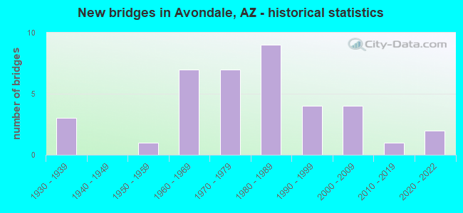
- New bridges - historical statistics
- 31930-1939
- 11950-1959
- 71960-1969
- 71970-1979
- 91980-1989
- 41990-1999
- 42000-2009
- 12010-2019
- 22020-2022
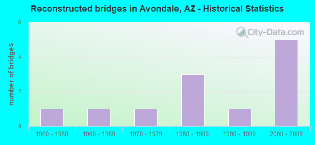
- Reconstructed bridges - Historical Statistics
- 11950-1959
- 11960-1969
- 11970-1979
- 31980-1989
- 11990-1999
- 52000-2009
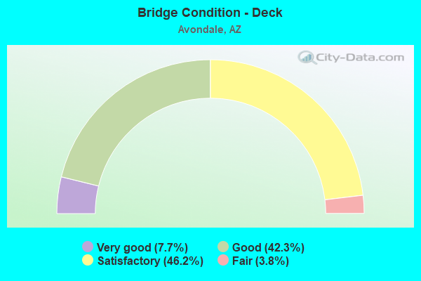
- Bridge Condition - Deck
- 7.7%Very good
- 42.3%Good
- 46.2%Satisfactory
- 3.8%Fair
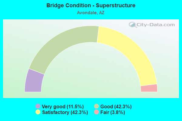
- Bridge Condition - Superstructure
- 11.5%Very good
- 42.3%Good
- 42.3%Satisfactory
- 3.8%Fair
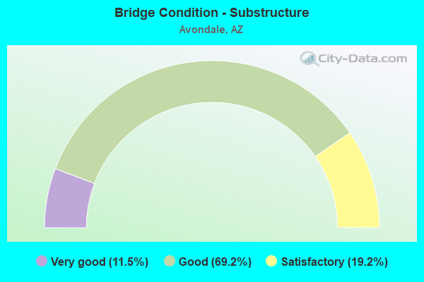
- Bridge Condition - Substructure
- 11.5%Very good
- 69.2%Good
- 19.2%Satisfactory
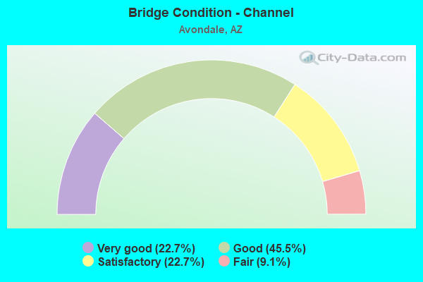
- Bridge Condition - Channel
- 22.7%Very good
- 45.5%Good
- 22.7%Satisfactory
- 9.1%Fair
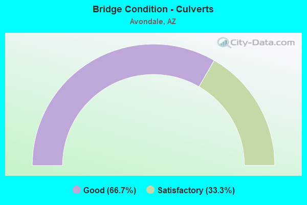
- Bridge Condition - Culverts
- 66.7%Good
- 33.3%Satisfactory
Find on map >> Show street view
Structure Number: 134, Location: 35.8 mi E Jct I-40 (Lat: 35.467100, Lng: -113.600100), Route carried "on" structure: State highway 66, Year Built: 1934, Year Reconstructed: 1964, Status: Open, Structure Length: 3.35m (10.99ft), Average Daily Traffic: 1,342 (year 2019), Truck Traffic: 15%, Average Future Daily Traffic: 1,352 (year 2039), Design Load: HS 20, Features Intersected: Wash
Minimum Vertical Clearance: 30+ m (98+ ft), Kilometerpoint: 148.655, Lanes on structure: 2, Owner: State Highway Agency, Approaching Roadway Width: 12.2m (40.0ft), Skew: 3 degrees, Material/Design: Concrete, Design/Construction: Slab, Number Of Spans In Main Unit: 5, Length of Maximum Span: 6.7m (22.0ft), Curb-To-Curb Width: 13.3m (43.6ft), Out-to-Out Width: 14.2m (46.6ft)
Condition: Deck: Satisfactory, Superstructure: Satisfactory, Substructure: Satisfactory, Channel: Satisfactory, Operating Rating: 50.8 metric tons, Method Used To Determine Operating Rating: Load Factor (LF), Inventory Rating: 29.9 metric tons, Method Used To Determine Inventory Rating: Load Factor (LF), Structural Evaluation: Equal to present minimum criteria, Deck Geometry: Better than present minimum criteria, Waterway Adequacy: Equal to present minimum criteria, Approach Roadway Alignment: Equal to present desirable criteria, Designated Inspection Frequency: Every 24 months, Inspection Date: October 2020, Deck Structure Type: Concrete Cast-file-Place
Find on map >> Show street view
Structure Number: 1201, Location: Jct US 60 (Lat: 33.661300, Lng: -114.010900), Route carried "on" structure: US 60, Year Built: 1967, Status: Open, Structure Length: 11.49m (37.70ft), Average Daily Traffic: 1,739 (year 2020), Truck Traffic: 7%, Average Future Daily Traffic: 1,749 (year 2040), Design Load: HS 20, Features Intersected: I-10
Minimum Vertical Clearance: 30+ m (98+ ft), Kilometerpoint: 50.244, Lanes on structure: 2, Lanes under structure: 4, Owner: State Highway Agency, Approaching Roadway Width: 12.2m (40.0ft), Skew: 2 degrees, Material/Design: Concrete continuous, Design/Construction: Box Beam or Girders - Single/Spread, Number Of Spans In Main Unit: 3, Length of Maximum Span: 42.1m (138.1ft), Curb or Sidewalk Widths: Left: 0.5m (1.6ft), Right: 0.5m (1.6ft), Curb-To-Curb Width: 9.1m (29.9ft), Out-to-Out Width: 10.9m (35.8ft)
Condition: Deck: Good, Superstructure: Satisfactory, Substructure: Good, Operating Rating: 49.9 metric tons, Method Used To Determine Operating Rating: Load Factor (LF), Inventory Rating: 29.9 metric tons, Method Used To Determine Inventory Rating: Load Factor (LF), Structural Evaluation: Equal to present minimum criteria, Deck Geometry: Somewhat better than minimum adequacy, Underclear: Meets minimum limits, Approach Roadway Alignment: Equal to present minimum criteria, Designated Inspection Frequency: Every 24 months, Inspection Date: January 2022, Deck Structure Type: Concrete Cast-file-Place, Wearing Surface/Protective System: Wearing Surface: Monolithic Concrete
Find on map >> Show street view
Structure Number: 1202, Location: 2.6 mi E Jct US 60 (Lat: 33.655800, Lng: -113.965600), Route carried "on" structure: County highway , Year Built: 1967, Status: Open, Structure Length: 10.06m (33.01ft), Average Daily Traffic: 10 (year 2020), Truck Traffic: 10%, Average Future Daily Traffic: 20 (year 2040), Design Load: HS 20, Features Intersected: I-10, Facility Carried by Structure: Ramsey Mine Rd
Minimum Vertical Clearance: 30+ m (98+ ft), Kilometerpoint: 0.000, Lanes on structure: 2, Lanes under structure: 4, Owner: State Highway Agency, Approaching Roadway Width: 7.9m (25.9ft), Material/Design: Concrete continuous, Design/Construction: Box Beam or Girders - Single/Spread, Number Of Spans In Main Unit: 3, Length of Maximum Span: 38.1m (125.0ft), Curb or Sidewalk Widths: Left: 0.5m (1.6ft), Right: 0.5m (1.6ft), Curb-To-Curb Width: 7.9m (25.9ft), Out-to-Out Width: 9.6m (31.5ft)
Condition: Deck: Good, Superstructure: Satisfactory, Substructure: Good, Operating Rating: 86.2 metric tons, Method Used To Determine Operating Rating: Load Factor (LF), Inventory Rating: 50.8 metric tons, Method Used To Determine Inventory Rating: Load Factor (LF), Structural Evaluation: Equal to present minimum criteria, Deck Geometry: Equal to present minimum criteria, Underclear: High priority of corrective action, Approach Roadway Alignment: Equal to present minimum criteria, Designated Inspection Frequency: Every 24 months, Inspection Date: January 2022, Deck Structure Type: Concrete Cast-file-Place, Wearing Surface/Protective System: Wearing Surface: Monolithic Concrete
Find on map >> Show street view
Structure Number: 1233, Location: 8.8 mi E Jct US 191 (Lat: 32.317256, Lng: -109.484386), Route carried "on" structure: Interstate 10, Year Built: 1967, Status: Open, Structure Length: 3.29m (10.79ft), Average Daily Traffic: 2,117 (year 2019), Truck Traffic: 17%, Average Future Daily Traffic: 2,127 (year 2039), Design Load: HS 20, Features Intersected: Apache Pass Rd
Minimum Vertical Clearance: 5.18m (16.99ft), Kilometerpoint: 587.073, Lanes on structure: 2, Lanes under structure: 2, Owner: State Highway Agency, Approaching Roadway Width: 11.6m (38.1ft), Material/Design: Concrete continuous, Design/Construction: Slab, Number Of Spans In Main Unit: 3, Length of Maximum Span: 12.2m (40.0ft), Curb-To-Curb Width: 11.7m (38.4ft), Out-to-Out Width: 12.6m (41.3ft)
Condition: Deck: Satisfactory, Superstructure: Satisfactory, Substructure: Satisfactory, Operating Rating: 51.7 metric tons, Method Used To Determine Operating Rating: Load Factor (LF), Inventory Rating: 30.8 metric tons, Method Used To Determine Inventory Rating: Load Factor (LF), Structural Evaluation: Equal to present minimum criteria, Deck Geometry: Equal to present minimum criteria, Underclear: Meets minimum limits, Approach Roadway Alignment: Equal to present desirable criteria, Designated Inspection Frequency: Every 24 months, Inspection Date: September 2021, Deck Structure Type: Concrete Cast-file-Place, Wearing Surface/Protective System: Wearing Surface: Monolithic Concrete
Find on map >> Show street view
Structure Number: 1234, Location: 8.8 mi E Jct US 191 (Lat: 32.317558, Lng: -109.484386), Route carried "on" structure: Interstate 10, Year Built: 1967, Status: Open, Structure Length: 3.29m (10.79ft), Average Daily Traffic: 5,280 (year 2019), Truck Traffic: 17%, Average Future Daily Traffic: 5,290 (year 2039), Design Load: HS 20, Features Intersected: Apache Pass Rd
Minimum Vertical Clearance: 5.18m (16.99ft), Kilometerpoint: 587.073, Lanes on structure: 2, Lanes under structure: 2, Owner: State Highway Agency, Approaching Roadway Width: 11.6m (38.1ft), Material/Design: Concrete continuous, Design/Construction: Slab, Number Of Spans In Main Unit: 3, Length of Maximum Span: 12.2m (40.0ft), Curb-To-Curb Width: 11.7m (38.4ft), Out-to-Out Width: 12.6m (41.3ft)
Condition: Deck: Satisfactory, Superstructure: Satisfactory, Substructure: Satisfactory, Operating Rating: 54.4 metric tons, Method Used To Determine Operating Rating: Load Factor (LF), Inventory Rating: 32.7 metric tons, Method Used To Determine Inventory Rating: Load Factor (LF), Structural Evaluation: Equal to present minimum criteria, Deck Geometry: Equal to present minimum criteria, Underclear: Meets minimum limits, Approach Roadway Alignment: Equal to present desirable criteria, Designated Inspection Frequency: Every 24 months, Inspection Date: September 2021, Deck Structure Type: Concrete Cast-file-Place, Wearing Surface/Protective System: Wearing Surface: Latex Concrete
Find on map >> Show street view
Structure Number: 1817, Location: 1.9 mi N of Jct SR 85 (Lat: 33.460294, Lng: -112.306558), Route carried "on" structure: ServiceState highway 10, Year Built: 1982, Year Reconstructed: 2011, Status: Open, Structure Length: 3.29m (10.79ft), Average Daily Traffic: 24,740 (year 2017), Truck Traffic: 4%, Average Future Daily Traffic: 24,750 (year 2037), Design Load: HS 20, Features Intersected: Papago W Drain Channel, Facility Carried by Structure: Avondale Blvd
Minimum Vertical Clearance: 30+ m (98+ ft), Kilometerpoint: 211.951, Lanes on structure: 8, Owner: State Highway Agency, Approaching Roadway Width: 37.5m (123.0ft), Skew: 21 degrees, Material/Design: Concrete continuous, Design/Construction: Slab, Number Of Spans In Main Unit: 3, Length of Maximum Span: 12.2m (40.0ft), Curb or Sidewalk Widths: Left: 1.7m (5.6ft), Right: 2.2m (7.2ft), Curb-To-Curb Width: 37.4m (122.7ft), Out-to-Out Width: 42.3m (138.8ft)
Condition: Deck: Good, Superstructure: Good, Substructure: Good, Channel: Good, Operating Rating: 59.9 metric tons, Method Used To Determine Operating Rating: Load Factor (LF), Inventory Rating: 36.3 metric tons, Method Used To Determine Inventory Rating: Load Factor (LF), Structural Evaluation: Better than present minimum criteria, Deck Geometry: Superior to present desirable criteria, Waterway Adequacy: Equal to present desirable criteria, Approach Roadway Alignment: Better than present minimum criteria, Designated Inspection Frequency: Every 24 months, Inspection Date: Febuary 2021, Deck Structure Type: Concrete Cast-file-Place, Wearing Surface/Protective System: Wearing Surface: Monolithic Concrete
Find on map >> Show street view
Structure Number: 1818, Location: 300 ft N Jct I-10 (Lat: 33.462100, Lng: -112.289900), Route carried "on" structure: ServiceState highway 10, Year Built: 1982, Year Reconstructed: 1994, Status: Open, Structure Length: 2.47m (8.10ft), Average Daily Traffic: 18,690 (year 2017), Truck Traffic: 10%, Average Future Daily Traffic: 18,700 (year 2037), Design Load: HS 20, Features Intersected: Papago W Drain Channel
Minimum Vertical Clearance: 30+ m (98+ ft), Kilometerpoint: 213.528, Lanes on structure: 5, Owner: State Highway Agency, Approaching Roadway Width: 24.4m (80.1ft), Skew: 20 degrees, Material/Design: Prestressed concrete, Design/Construction: Box Beam or Girders - Multiple, Number Of Spans In Main Unit: 1, Length of Maximum Span: 23.8m (78.1ft), Curb or Sidewalk Widths: Left: 3.7m (12.1ft), Right: 3.7m (12.1ft), Curb-To-Curb Width: 24.4m (80.1ft), Out-to-Out Width: 33.3m (109.3ft)
Condition: Deck: Satisfactory, Superstructure: Good, Substructure: Good, Channel: Very good, Operating Rating: 74.4 metric tons, Method Used To Determine Operating Rating: Load Factor (LF), Inventory Rating: 41.7 metric tons, Method Used To Determine Inventory Rating: Load Factor (LF), Structural Evaluation: Better than present minimum criteria, Deck Geometry: Superior to present desirable criteria, Waterway Adequacy: Equal to present desirable criteria, Approach Roadway Alignment: Equal to present desirable criteria, Designated Inspection Frequency: Every 24 months, Inspection Date: Febuary 2021, Deck Structure Type: Concrete Cast-file-Place, Wearing Surface/Protective System: Wearing Surface: Bituminous
Find on map >> Show street view
Structure Number: 1852, Location: 19.2 mi W Jct I 17 (Lat: 33.457792, Lng: -112.335867), Route carried "on" structure: Interstate 10, Year Built: 1979, Year Reconstructed: 2012, Status: Open, Structure Length: 45.78m (150.20ft), Average Daily Traffic: 197,932 (year 2019), Truck Traffic: 10%, Average Future Daily Traffic: 197,942 (year 2039), Design Load: HS 20, Features Intersected: Agua Fria River
Minimum Vertical Clearance: 7.47m (24.51ft), Kilometerpoint: 209.215, Lanes on structure: 11, Owner: State Highway Agency, Approaching Roadway Width: 53.9m (176.8ft), Skew: 31 degrees, Material/Design: Prestressed concrete continuous, Design/Construction: Stringer/Multi-beam, Number Of Spans In Main Unit: 20, Length of Maximum Span: 22.9m (75.1ft), Curb-To-Curb Width: 60.6m (198.8ft), Out-to-Out Width: 62.4m (204.7ft)
Condition: Deck: Satisfactory, Superstructure: Good, Substructure: Good, Channel: Good, Operating Rating: 85.3 metric tons, Method Used To Determine Operating Rating: Load Factor (LF), Inventory Rating: 32.7 metric tons, Method Used To Determine Inventory Rating: Load Factor (LF), Structural Evaluation: Better than present minimum criteria, Deck Geometry: Superior to present desirable criteria, Waterway Adequacy: Equal to present desirable criteria, Approach Roadway Alignment: Equal to present desirable criteria, Designated Inspection Frequency: Every 24 months, Inspection Date: Febuary 2021, Deck Structure Type: Concrete Cast-file-Place, Wearing Surface/Protective System: Wearing Surface: Bituminous
Find on map >> Show street view
Structure Number: 1856, Location: 13.5 mi W of Jct I 17 (Lat: 33.459300, Lng: -112.306900), Route carried "on" structure: Interstate 10, Year Built: 1981, Year Reconstructed: 2009, Status: Open, Structure Length: 4.66m (15.29ft), Average Daily Traffic: 197,932 (year 2019), Truck Traffic: 10%, Average Future Daily Traffic: 197,942 (year 2039), Design Load: HS 20, Features Intersected: Avondale Blvd
Minimum Vertical Clearance: 30+ m (98+ ft), Kilometerpoint: 211.918, Lanes on structure: 10, Lanes under structure: 10, Owner: State Highway Agency, Approaching Roadway Width: 50.9m (167.0ft), Skew: 31 degrees, Material/Design: Prestressed concrete, Design/Construction: Box Beam or Girders - Single/Spread, Number Of Spans In Main Unit: 1, Length of Maximum Span: 45.7m (149.9ft), Curb-To-Curb Width: 50.8m (166.7ft), Out-to-Out Width: 52.8m (173.2ft)
Condition: Deck: Good, Superstructure: Good, Substructure: Good, Operating Rating: 89.8 metric tons, Method Used To Determine Operating Rating: Load Factor (LF), Inventory Rating: 63.5 metric tons, Method Used To Determine Inventory Rating: Load Factor (LF), Structural Evaluation: Better than present minimum criteria, Deck Geometry: Superior to present desirable criteria, Underclear: Somewhat better than minimum adequacy, Approach Roadway Alignment: Equal to present desirable criteria, Designated Inspection Frequency: Every 24 months, Inspection Date: Febuary 2021, Deck Structure Type: Concrete Cast-file-Place, Wearing Surface/Protective System: Wearing Surface: Bituminous
Find on map >> Show street view
Structure Number: 186, Location: 0.2 mi W Jct SR 101L (Lat: 33.461567, Lng: -112.272792), Route carried "on" structure: Interstate 10, Year Built: 1981, Year Reconstructed: 2009, Status: Open, Structure Length: 4.66m (15.29ft), Average Daily Traffic: 217,460 (year 2019), Truck Traffic: 8%, Average Future Daily Traffic: 217,470 (year 2039), Design Load: HS 20, Features Intersected: 99th Avenue
Minimum Vertical Clearance: 30+ m (98+ ft), Kilometerpoint: 215.105, Lanes on structure: 10, Lanes under structure: 8, Owner: State Highway Agency, Approaching Roadway Width: 50.9m (167.0ft), Material/Design: Prestressed concrete, Design/Construction: Box Beam or Girders - Single/Spread, Number Of Spans In Main Unit: 1, Length of Maximum Span: 45.7m (149.9ft), Curb-To-Curb Width: 50.8m (166.7ft), Out-to-Out Width: 52.8m (173.2ft)
Condition: Deck: Good, Superstructure: Good, Substructure: Good, Operating Rating: 53.5 metric tons, Method Used To Determine Operating Rating: Load Factor (LF), Inventory Rating: 32.7 metric tons, Method Used To Determine Inventory Rating: Load Factor (LF), Structural Evaluation: Better than present minimum criteria, Deck Geometry: Superior to present desirable criteria, Underclear: High priority of corrective action, Approach Roadway Alignment: Equal to present desirable criteria, Designated Inspection Frequency: Every 24 months, Inspection Date: Febuary 2021, Deck Structure Type: Concrete Cast-file-Place, Wearing Surface/Protective System: Wearing Surface: Bituminous
Find on map >> Show street view
Structure Number: 2068, Location: 26.4 mi E Jct I-10 (Lat: 33.387000, Lng: -111.511800), Route carried "on" structure: US 60, Year Built: 1990, Status: Open, Structure Length: 4.82m (15.81ft), Average Daily Traffic: 30,111 (year 2018), Truck Traffic: 7%, Average Future Daily Traffic: 30,121 (year 2038), Design Load: HS 20, Features Intersected: Goldfield Road
Minimum Vertical Clearance: 7.62m (25.00ft), Kilometerpoint: 319.294, Lanes on structure: 4, Lanes under structure: 6, Owner: State Highway Agency, Approaching Roadway Width: 24.4m (80.1ft), Skew: 30 degrees, Material/Design: Prestressed concrete, Design/Construction: Box Beam or Girders - Single/Spread, Number Of Spans In Main Unit: 1, Length of Maximum Span: 47.2m (154.9ft), Curb-To-Curb Width: 35.3m (115.8ft), Out-to-Out Width: 36.9m (121.1ft)
Condition: Deck: Good, Superstructure: Satisfactory, Substructure: Good, Operating Rating: 71.7 metric tons, Method Used To Determine Operating Rating: Load Factor (LF), Inventory Rating: 34.5 metric tons, Method Used To Determine Inventory Rating: Load Factor (LF), Structural Evaluation: Equal to present minimum criteria, Deck Geometry: Superior to present desirable criteria, Underclear: High priority of corrective action, Approach Roadway Alignment: Equal to present desirable criteria, Designated Inspection Frequency: Every 24 months, Inspection Date: October 2021, Deck Structure Type: Concrete Cast-file-Place, Wearing Surface/Protective System: Wearing Surface: Bituminous
Find on map >> Show street view
Structure Number: 2201, Location: 0.2 mi W Jct SR 101L (Lat: 33.461900, Lng: -112.272800), Route carried "on" structure: Ramp Interstate 10, Year Built: 1998, Status: Open, Structure Length: 34.75m (114.01ft), Average Daily Traffic: 60,668 (year 2015), Truck Traffic: 6%, Average Future Daily Traffic: 60,678 (year 2035), Design Load: HS 20, Features Intersected: Drainage CA/Rmp99C/99Av, Facility Carried by Structure: Ramp S-W
Minimum Vertical Clearance: 30+ m (98+ ft), Kilometerpoint: 215.105, Lanes on structure: 1, Lanes under structure: 11, Owner: State Highway Agency, Approaching Roadway Width: 8.5m (27.9ft), Material/Design: Prestressed concrete continuous, Design/Construction: Box Beam or Girders - Single/Spread, Number Of Spans In Main Unit: 6, Length of Maximum Span: 62.5m (205.1ft), Curb-To-Curb Width: 8.5m (27.9ft), Out-to-Out Width: 9.5m (31.2ft)
Condition: Deck: Good, Superstructure: Good, Substructure: Good, Channel: Good, Operating Rating: 76.2 metric tons, Method Used To Determine Operating Rating: Load Factor (LF), Inventory Rating: 46.3 metric tons, Method Used To Determine Inventory Rating: Load Factor (LF), Structural Evaluation: Better than present minimum criteria, Deck Geometry: Superior to present desirable criteria, Underclear: High priority of corrective action, Waterway Adequacy: Equal to present desirable criteria, Approach Roadway Alignment: Equal to present desirable criteria, Designated Inspection Frequency: Every 24 months, Inspection Date: Febuary 2021, Deck Structure Type: Concrete Cast-file-Place, Wearing Surface/Protective System: Wearing Surface: Bituminous
Find on map >> Show street view
Structure Number: 2307, Location: 12.5 mi W Jct I-17 (Lat: 33.461300, Lng: -112.290200), Route carried "on" structure: Interstate 10, Year Built: 2009, Status: Open, Structure Length: 6.10m (20.01ft), Average Daily Traffic: 217,460 (year 2019), Truck Traffic: 8%, Average Future Daily Traffic: 217,470 (year 2039), Design Load: HS 25 or greater, Features Intersected: 107th Avenue
Minimum Vertical Clearance: 6.10m (20.01ft), Kilometerpoint: 213.496, Lanes on structure: 13, Lanes under structure: 6, Owner: State Highway Agency, Approaching Roadway Width: 65.5m (214.9ft), Skew: 30 degrees, Material/Design: Prestressed concrete continuous, Design/Construction: Stringer/Multi-beam, Number Of Spans In Main Unit: 2, Length of Maximum Span: 29.9m (98.1ft), Curb-To-Curb Width: 65.5m (214.9ft), Out-to-Out Width: 67.3m (220.8ft)
Condition: Deck: Very good, Superstructure: Very good, Substructure: Good, Operating Rating: 89.8 metric tons, Method Used To Determine Operating Rating: Load Factor (LF), Inventory Rating: 38.1 metric tons, Method Used To Determine Inventory Rating: Load Factor (LF), Structural Evaluation: Better than present minimum criteria, Deck Geometry: Superior to present desirable criteria, Underclear: High priority of corrective action, Approach Roadway Alignment: Equal to present desirable criteria, Designated Inspection Frequency: Every 24 months, Inspection Date: Febuary 2021, Deck Structure Type: Concrete Cast-file-Place, Wearing Surface/Protective System: Wearing Surface: Bituminous
Find on map >> Show street view
Structure Number: 2934, Location: N of Junc I-10 (Lat: 32.727000, Lng: -111.516400), Route carried "on" structure: State highway 87, Year Built: 2018, Status: Open, Structure Length: 10.88m (35.70ft), Average Daily Traffic: 2,809 (year 2018), Truck Traffic: 18%, Average Future Daily Traffic: 2,819 (year 2038), Design Load: HL 93, Features Intersected: UPRR
Minimum Vertical Clearance: 30+ m (98+ ft), Kilometerpoint: 185.573, Lanes on structure: 6, Owner: State Highway Agency, Approaching Roadway Width: 20.7m (67.9ft), Skew: 2 degrees, Material/Design: Prestressed concrete continuous, Design/Construction: Stringer/Multi-beam, Number Of Spans In Main Unit: 3, Length of Maximum Span: 41.1m (134.8ft), Curb or Sidewalk Widths: Left: 0.0m, Right: 2.0m (6.6ft), Curb-To-Curb Width: 31.2m (102.4ft), Out-to-Out Width: 34.0m (111.5ft)
Condition: Deck: Good, Superstructure: Very good, Substructure: Very good, Operating Rating: 89.8 metric tons, Method Used To Determine Operating Rating: Load Factor (LF), Inventory Rating: 33.6 metric tons, Method Used To Determine Inventory Rating: Load Factor (LF), Structural Evaluation: Equal to present desirable criteria, Deck Geometry: Superior to present desirable criteria, Underclear: Superior to present desirable criteria, Approach Roadway Alignment: Equal to present desirable criteria, Designated Inspection Frequency: Every 24 months, Inspection Date: November 2020, Deck Structure Type: Concrete Cast-file-Place, Wearing Surface/Protective System: Wearing Surface: Monolithic Concrete
Find on map >> Show street view
Structure Number: 4499, Location: 5.4 mi E Jct US 191 (Lat: 31.378847, Lng: -109.519933), Route carried "on" structure: State highway 80, Year Built: 1930, Year Reconstructed: 2002, Status: Open, Structure Length: 0.73m (2.40ft), Average Daily Traffic: 576 (year 2018), Truck Traffic: 21%, Average Future Daily Traffic: 801 (year 2040), Design Load: HS 20, Features Intersected: Wash
Minimum Vertical Clearance: 30+ m (98+ ft), Kilometerpoint: 595.666, Lanes on structure: 2, Owner: State Highway Agency, Approaching Roadway Width: 10.4m (34.1ft), Skew: 4 degrees, Material/Design: Concrete continuous, Design/Construction: Culvert, Number Of Spans In Main Unit: 2, Length of Maximum Span: 2.4m (7.9ft)
Condition: Channel: Good, Culverts: Good, Operating Rating: 74.4 metric tons, Method Used To Determine Operating Rating: Load Factor (LF), Inventory Rating: 44.5 metric tons, Method Used To Determine Inventory Rating: Load Factor (LF), Structural Evaluation: Better than present minimum criteria, Waterway Adequacy: Equal to present minimum criteria, Approach Roadway Alignment: Equal to present minimum criteria, Designated Inspection Frequency: Every 48 months, Inspection Date: April 2020
Find on map >> Show street view
Structure Number: 459, Location: 56.2 mi E Jct SR 85 (Lat: 31.958900, Lng: -111.948400), Route carried "on" structure: State highway 86, Year Built: 1951, Status: Open, Structure Length: 0.98m (3.22ft), Average Daily Traffic: 1,829 (year 2017), Truck Traffic: 10%, Average Future Daily Traffic: 1,839 (year 2038), Design Load: HS 20, Features Intersected: Wash
Minimum Vertical Clearance: 30+ m (98+ ft), Kilometerpoint: 175.579, Lanes on structure: 2, Owner: State Highway Agency, Approaching Roadway Width: 8.2m (26.9ft), Material/Design: Concrete continuous, Design/Construction: Culvert, Number Of Spans In Main Unit: 3, Length of Maximum Span: 3.0m (9.8ft), Curb or Sidewalk Widths: Left: 0.3m (1.0ft), Right: 0.3m (1.0ft), Curb-To-Curb Width: 9.5m (31.2ft), Out-to-Out Width: 10.1m (33.1ft)
Condition: Channel: Good, Culverts: Good, Operating Rating: 52.6 metric tons, Method Used To Determine Operating Rating: Load Factor (LF), Inventory Rating: 31.8 metric tons, Method Used To Determine Inventory Rating: Load Factor (LF), Structural Evaluation: Better than present minimum criteria, Deck Geometry: Somewhat better than minimum adequacy, Waterway Adequacy: Better than present minimum criteria, Approach Roadway Alignment: Equal to present minimum criteria, Designated Inspection Frequency: Every 48 months, Inspection Date: November 2018, Deck Structure Type: Concrete Cast-file-Place, Wearing Surface/Protective System: Wearing Surface: Bituminous
Find on map >> Show street view
Structure Number: 573, Location: 22.2 mi S Utah Bdry (Lat: 36.878400, Lng: -113.949900), Route carried "on" structure: Interstate 15, Year Built: 1962, Year Reconstructed: 1980, Status: Open, Structure Length: 0.64m (2.10ft), Average Daily Traffic: 13,082 (year 2018), Truck Traffic: 33%, Average Future Daily Traffic: 13,092 (year 2040), Design Load: HS 20, Features Intersected: Wash
Minimum Vertical Clearance: 30+ m (98+ ft), Kilometerpoint: 11.523, Lanes on structure: 2, Owner: State Highway Agency, Approaching Roadway Width: 11.6m (38.1ft), Material/Design: Concrete continuous, Design/Construction: Culvert, Number Of Spans In Main Unit: 2, Length of Maximum Span: 3.0m (9.8ft)
Condition: Channel: Very good, Culverts: Good, Operating Rating: 60.8 metric tons, Method Used To Determine Operating Rating: Load Factor (LF), Inventory Rating: 36.3 metric tons, Method Used To Determine Inventory Rating: Load Factor (LF), Structural Evaluation: Better than present minimum criteria, Waterway Adequacy: Equal to present desirable criteria, Approach Roadway Alignment: Equal to present desirable criteria, Designated Inspection Frequency: Every 48 months, Inspection Date: October 2020
Find on map >> Show street view
Structure Number: 6053, Location: 23.1 mi North Jct I 19 (Lat: 32.454500, Lng: -111.204700), Route carried "on" structure: ServiceState highway 10, Year Built: 1931, Status: Open, Structure Length: 1.68m (5.51ft), Average Daily Traffic: 368 (year 2017), Truck Traffic: 5%, Average Future Daily Traffic: 378 (year 2038), Design Load: HS 20, Features Intersected: Wash
Minimum Vertical Clearance: 30+ m (98+ ft), Kilometerpoint: 382.010, Lanes on structure: 2, Owner: State Highway Agency, Approaching Roadway Width: 7.3m (24.0ft), Material/Design: Concrete continuous, Design/Construction: Culvert, Number Of Spans In Main Unit: 5, Length of Maximum Span: 3.0m (9.8ft), Curb-To-Curb Width: 9.8m (32.2ft), Out-to-Out Width: 10.2m (33.5ft)
Condition: Channel: Fair, Culverts: Satisfactory, Operating Rating: 52.6 metric tons, Method Used To Determine Operating Rating: Load Factor (LF), Inventory Rating: 31.8 metric tons, Method Used To Determine Inventory Rating: Load Factor (LF), Structural Evaluation: Equal to present minimum criteria, Deck Geometry: Better than present minimum criteria, Waterway Adequacy: Equal to present desirable criteria, Approach Roadway Alignment: Equal to present desirable criteria, Designated Inspection Frequency: Every 48 months, Inspection Date: September 2018, Deck Structure Type: Concrete Cast-file-Place, Wearing Surface/Protective System: Wearing Surface: Bituminous
Find on map >> Show street view
Structure Number: 6221, Location: 39.4 mi East of Jct US 60 (Lat: 33.566300, Lng: -113.337200), Route carried "on" structure: Interstate 10, Year Built: 1972, Status: Open, Structure Length: 0.98m (3.22ft), Average Daily Traffic: 11,331 (year 2016), Truck Traffic: 24%, Average Future Daily Traffic: 11,341 (year 2036), Design Load: HS 20, Features Intersected: Wash
Minimum Vertical Clearance: 30+ m (98+ ft), Kilometerpoint: 113.600, Lanes on structure: 2, Owner: State Highway Agency, Approaching Roadway Width: 11.6m (38.1ft), Material/Design: Concrete continuous, Design/Construction: Culvert, Number Of Spans In Main Unit: 3, Length of Maximum Span: 3.0m (9.8ft)
Condition: Channel: Very good, Culverts: Good, Operating Rating: 89.8 metric tons, Method Used To Determine Operating Rating: Load Factor (LF), Inventory Rating: 89.8 metric tons, Method Used To Determine Inventory Rating: Load Factor (LF), Structural Evaluation: Better than present minimum criteria, Waterway Adequacy: Better than present minimum criteria, Approach Roadway Alignment: Equal to present desirable criteria, Designated Inspection Frequency: Every 48 months, Inspection Date: November 2021
Find on map >> Show street view
Structure Number: 7556, Location: 1 mi W/ El Mirage Rd (Lat: 33.420825, Lng: -112.341669), Route carried "on" structure: County highway , Year Built: 1988, Status: Open, Structure Length: 1.10m (3.61ft), Average Daily Traffic: 8,107 (year 2017), Truck Traffic: 10%, Average Future Daily Traffic: 8,117 (year 2037), Design Load: HS 20, Features Intersected: AFR Diversion Channel, Facility Carried by Structure: Lower Buckeye Rd
Minimum Vertical Clearance: 30+ m (98+ ft), Kilometerpoint: 0.000, Lanes on structure: 2, Owner: County Highway Agency, Approaching Roadway Width: 8.5m (27.9ft), Skew: 2 degrees, Material/Design: Concrete continuous, Design/Construction: Culvert, Number Of Spans In Main Unit: 3, Length of Maximum Span: 3.7m (12.1ft)
Condition: Channel: Good, Culverts: Satisfactory, Structural Evaluation: Equal to present minimum criteria, Waterway Adequacy: Equal to present desirable criteria, Approach Roadway Alignment: Equal to present minimum criteria, Designated Inspection Frequency: Every 48 months, Inspection Date: October 2018
Find on map >> Show street view
Structure Number: 7559, Location: 0.3 mi E of Dysart Rd (Lat: 33.449800, Lng: -112.335000), Route carried "on" structure: City street , Year Built: 1988, Status: Open, Structure Length: 35.45m (116.31ft), Average Daily Traffic: 16,527 (year 2020), Truck Traffic: 5%, Average Future Daily Traffic: 16,537 (year 2040), Design Load: HS 20, Features Intersected: Agua Fria River, Facility Carried by Structure: Van Buren Street
Minimum Vertical Clearance: 9.14m (29.99ft), Kilometerpoint: 0.000, Lanes on structure: 4, Owner: City or Municipal Highway Agency, Approaching Roadway Width: 20.7m (67.9ft), Material/Design: Prestressed concrete continuous, Design/Construction: Stringer/Multi-beam, Number Of Spans In Main Unit: 10, Length of Maximum Span: 35.4m (116.1ft), Curb or Sidewalk Widths: Left: 0.0m, Right: 1.8m (5.9ft), Curb-To-Curb Width: 20.7m (67.9ft), Out-to-Out Width: 23.8m (78.1ft)
Condition: Deck: Satisfactory, Superstructure: Good, Substructure: Good, Channel: Good, Operating Rating: 54.4 metric tons, Method Used To Determine Operating Rating: Load Factor (LF), Inventory Rating: 32.7 metric tons, Method Used To Determine Inventory Rating: Load Factor (LF), Structural Evaluation: Better than present minimum criteria, Deck Geometry: Superior to present desirable criteria, Waterway Adequacy: Equal to present desirable criteria, Approach Roadway Alignment: Equal to present desirable criteria, Designated Inspection Frequency: Every 24 months, Inspection Date: May 2021, Deck Structure Type: Concrete Cast-file-Place, Wearing Surface/Protective System: Wearing Surface: Monolithic Concrete
Find on map >> Show street view
Structure Number: 7819, Location: 0.5 mi W/ El Mirage (Lat: 33.435117, Lng: -112.332158), Route carried "on" structure: County highway , Year Built: 1973, Status: Open, Structure Length: 36.67m (120.31ft), Average Daily Traffic: 17,466 (year 2020), Truck Traffic: 20%, Average Future Daily Traffic: 17,476 (year 2040), Design Load: HS 20, Features Intersected: Agua Fria River, Facility Carried by Structure: MC-85 Hwy
Minimum Vertical Clearance: 30+ m (98+ ft), Kilometerpoint: 0.000, Lanes on structure: 4, Owner: County Highway Agency, Approaching Roadway Width: 20.7m (67.9ft), Material/Design: Prestressed concrete continuous, Design/Construction: Stringer/Multi-beam, Number Of Spans In Main Unit: 15, Length of Maximum Span: 24.4m (80.1ft), Curb or Sidewalk Widths: Left: 0.0m, Right: 1.2m (3.9ft), Curb-To-Curb Width: 20.7m (67.9ft), Out-to-Out Width: 22.9m (75.1ft)
Condition: Deck: Good, Superstructure: Satisfactory, Substructure: Satisfactory, Channel: Good, Operating Rating: 58.0 metric tons, Method Used To Determine Operating Rating: Load Factor (LF), Inventory Rating: 33.9 metric tons, Method Used To Determine Inventory Rating: Load Factor (LF), Structural Evaluation: Equal to present minimum criteria, Deck Geometry: Superior to present desirable criteria, Waterway Adequacy: Equal to present desirable criteria, Approach Roadway Alignment: Equal to present desirable criteria, Designated Inspection Frequency: Every 24 months, Inspection Date: November 2021, Deck Structure Type: Concrete Cast-file-Place, Wearing Surface/Protective System: Wearing Surface: Epoxy Overlay
Find on map >> Show street view
Structure Number: 8048, Location: 0.5 mi N Jct Thomas Rd (Lat: 33.486111, Lng: -112.290081), Route carried "on" structure: City street , Year Built: 1972, Year Reconstructed: 2006, Status: Open, Structure Length: 0.94m (3.08ft), Average Daily Traffic: 7,283 (year 2019), Truck Traffic: 5%, Average Future Daily Traffic: 7,293 (year 2039), Design Load: HS 20, Features Intersected: RID Canal, Facility Carried by Structure: 107th Ave
Minimum Vertical Clearance: 6.10m (20.01ft), Kilometerpoint: 0.000, Lanes on structure: 5, Owner: City or Municipal Highway Agency, Approaching Roadway Width: 22.6m (74.1ft), Material/Design: Prestressed concrete, Design/Construction: Box Beam or Girders - Multiple, Number Of Spans In Main Unit: 1, Length of Maximum Span: 9.1m (29.9ft), Curb or Sidewalk Widths: Left: 1.5m (4.9ft), Right: 1.8m (5.9ft), Curb-To-Curb Width: 22.6m (74.1ft), Out-to-Out Width: 26.9m (88.3ft)
Condition: Deck: Satisfactory, Superstructure: Satisfactory, Substructure: Good, Channel: Very good, Operating Rating: 67.1 metric tons, Method Used To Determine Operating Rating: Load Factor (LF), Inventory Rating: 39.9 metric tons, Method Used To Determine Inventory Rating: Load Factor (LF), Structural Evaluation: Equal to present minimum criteria, Deck Geometry: Equal to present minimum criteria, Waterway Adequacy: Equal to present desirable criteria, Approach Roadway Alignment: Equal to present desirable criteria, Designated Inspection Frequency: Every 24 months, Inspection Date: March 2020, Deck Structure Type: Concrete Precast Panels, Wearing Surface/Protective System: Wearing Surface: Bituminous
Find on map >> Show street view
Structure Number: 9021, Location: 0.1 mi E Jct Craycroft Rd (Lat: 32.250700, Lng: -110.872800), Route carried "on" structure: City street , Year Built: 1964, Year Reconstructed: 1971, Status: Open, Structure Length: 2.07m (6.79ft), Average Daily Traffic: 41,100 (year 2017), Truck Traffic: 5%, Average Future Daily Traffic: 41,110 (year 2039), Design Load: HS 20, Features Intersected: Alamo Wash, Facility Carried by Structure: Grant Road
Minimum Vertical Clearance: 30+ m (98+ ft), Kilometerpoint: 0.000, Lanes on structure: 6, Owner: City or Municipal Highway Agency, Approaching Roadway Width: 29.9m (98.1ft), Skew: 24 degrees, Material/Design: Concrete continuous, Design/Construction: Slab, Number Of Spans In Main Unit: 3, Length of Maximum Span: 7.6m (24.9ft), Curb or Sidewalk Widths: Left: 1.4m (4.6ft), Right: 1.4m (4.6ft), Curb-To-Curb Width: 29.9m (98.1ft), Out-to-Out Width: 33.2m (108.9ft)
Condition: Deck: Satisfactory, Superstructure: Satisfactory, Substructure: Satisfactory, Channel: Satisfactory, Operating Rating: 36.3 metric tons, Method Used To Determine Operating Rating: Load Factor (LF), Inventory Rating: 21.8 metric tons, Method Used To Determine Inventory Rating: Load Factor (LF), Structural Evaluation: Somewhat better than minimum adequacy, Deck Geometry: Superior to present desirable criteria, Waterway Adequacy: Equal to present desirable criteria, Approach Roadway Alignment: Equal to present desirable criteria, Designated Inspection Frequency: Every 24 months, Inspection Date: March 2021, Deck Structure Type: Concrete Cast-file-Place, Wearing Surface/Protective System: Wearing Surface: Bituminous
Find on map >> Show street view
Structure Number: 9145, Location: 0.5 mi E/ El Mirage (Lat: 33.493136, Lng: -112.315214), Route carried "on" structure: County highway , Year Built: 1970, Year Reconstructed: 1983, Status: Open, Structure Length: 49.47m (162.30ft), Average Daily Traffic: 24,045 (year 2019), Truck Traffic: 10%, Average Future Daily Traffic: 24,055 (year 2039), Design Load: HS 20, Features Intersected: Agua Fria River, Facility Carried by Structure: Indian School Rd
Minimum Vertical Clearance: 30+ m (98+ ft), Kilometerpoint: 0.000, Lanes on structure: 4, Owner: County Highway Agency, Approaching Roadway Width: 21.0m (68.9ft), Skew: 1 degrees, Material/Design: Prestressed concrete continuous, Design/Construction: Stringer/Multi-beam, Number Of Spans In Main Unit: 18, Length of Maximum Span: 27.4m (89.9ft), Curb-To-Curb Width: 22.6m (74.1ft), Out-to-Out Width: 23.6m (77.4ft)
Condition: Deck: Satisfactory, Superstructure: Satisfactory, Substructure: Good, Channel: Good, Operating Rating: 69.2 metric tons, Method Used To Determine Operating Rating: Load Factor (LF), Inventory Rating: 28.1 metric tons, Method Used To Determine Inventory Rating: Load Factor (LF), Structural Evaluation: Equal to present minimum criteria, Deck Geometry: Superior to present desirable criteria, Waterway Adequacy: Equal to present desirable criteria, Approach Roadway Alignment: Equal to present desirable criteria, Designated Inspection Frequency: Every 24 months, Inspection Date: November 2020, Deck Structure Type: Concrete Cast-file-Place, Wearing Surface/Protective System: Wearing Surface: Monolithic Concrete
Find on map >> Show street view
Structure Number: 9412, Location: 0.5 mi S Jct Ind Sch Rd (Lat: 33.484500, Lng: -112.340942), Route carried "on" structure: City street , Year Built: 1961, Year Reconstructed: 1994, Status: Open, Structure Length: 1.31m (4.30ft), Average Daily Traffic: 26,894 (year 2019), Truck Traffic: 5%, Average Future Daily Traffic: 26,904 (year 2039), Design Load: HS 20, Features Intersected: RID Canal, Facility Carried by Structure: Dysart Rd
Minimum Vertical Clearance: 30+ m (98+ ft), Kilometerpoint: 0.000, Lanes on structure: 6, Owner: City or Municipal Highway Agency, Approaching Roadway Width: 29.3m (96.1ft), Material/Design: Prestressed concrete, Design/Construction: Box Beam or Girders - Multiple, Number Of Spans In Main Unit: 1, Length of Maximum Span: 12.2m (40.0ft), Curb or Sidewalk Widths: Left: 1.8m (5.9ft), Right: 1.5m (4.9ft), Curb-To-Curb Width: 29.3m (96.1ft), Out-to-Out Width: 34.1m (111.9ft)
Condition: Deck: Good, Superstructure: Good, Substructure: Good, Channel: Fair, Operating Rating: 54.4 metric tons, Method Used To Determine Operating Rating: Load Factor (LF), Inventory Rating: 27.2 metric tons, Method Used To Determine Inventory Rating: Load Factor (LF), Structural Evaluation: Equal to present minimum criteria, Deck Geometry: Superior to present desirable criteria, Waterway Adequacy: Equal to present desirable criteria, Approach Roadway Alignment: Equal to present desirable criteria, Designated Inspection Frequency: Every 24 months, Inspection Date: March 2020, Deck Structure Type: Other, Wearing Surface/Protective System: Wearing Surface: Bituminous
Find on map >> Show street view
Structure Number: 9435, Location: 0.5 mi W Jct 99th Ave (Lat: 33.479106, Lng: -112.281111), Route carried "on" structure: City street , Year Built: 1975, Status: Open, Structure Length: 1.01m (3.31ft), Average Daily Traffic: 15,975 (year 2019), Truck Traffic: 5%, Average Future Daily Traffic: 15,985 (year 2039), Design Load: HS 25 or greater, Features Intersected: RID Canal, Facility Carried by Structure: Thomas Rd
Minimum Vertical Clearance: 30+ m (98+ ft), Kilometerpoint: 0.000, Lanes on structure: 5, Owner: City or Municipal Highway Agency, Approaching Roadway Width: 20.7m (67.9ft), Material/Design: Prestressed concrete, Design/Construction: Tee Beam, Number Of Spans In Main Unit: 1, Length of Maximum Span: 9.8m (32.2ft), Curb or Sidewalk Widths: Left: 1.6m (5.2ft), Right: 1.6m (5.2ft), Curb-To-Curb Width: 20.7m (67.9ft), Out-to-Out Width: 24.4m (80.1ft)
Condition: Deck: Satisfactory, Superstructure: Satisfactory, Substructure: Very good, Channel: Very good, Operating Rating: 36.3 metric tons, Method Used To Determine Operating Rating: Load Factor (LF), Inventory Rating: 21.8 metric tons, Method Used To Determine Inventory Rating: Load Factor (LF), Structural Evaluation: Somewhat better than minimum adequacy, Deck Geometry: Somewhat better than minimum adequacy, Waterway Adequacy: Equal to present desirable criteria, Approach Roadway Alignment: Equal to present desirable criteria, Designated Inspection Frequency: Every 24 months, Inspection Date: March 2020, Deck Structure Type: Concrete Cast-file-Place, Wearing Surface/Protective System: Wearing Surface: Monolithic Concrete
Find on map >> Show street view
Structure Number: 9896, Location: 0.75 mi E of Dysart Rd (Lat: 33.463300, Lng: -112.332000), Route carried "on" structure: City street , Year Built: 1985, Status: Open, Structure Length: 38.16m (125.20ft), Average Daily Traffic: 38,700 (year 2020), Truck Traffic: 3%, Average Future Daily Traffic: 38,710 (year 2040), Design Load: HS 20, Features Intersected: Agua Fria River, Facility Carried by Structure: McDowell Road
Minimum Vertical Clearance: 6.10m (20.01ft), Kilometerpoint: 0.000, Lanes on structure: 4, Owner: City or Municipal Highway Agency, Approaching Roadway Width: 15.8m (51.8ft), Skew: 2 degrees, Material/Design: Prestressed concrete continuous, Design/Construction: Stringer/Multi-beam, Number Of Spans In Main Unit: 10, Length of Maximum Span: 38.1m (125.0ft), Curb or Sidewalk Widths: Left: 1.7m (5.6ft), Right: 0.0m, Curb-To-Curb Width: 15.8m (51.8ft), Out-to-Out Width: 18.7m (61.4ft)
Condition: Deck: Satisfactory, Superstructure: Good, Substructure: Good, Channel: Good, Operating Rating: 84.4 metric tons, Method Used To Determine Operating Rating: Load Factor (LF), Inventory Rating: 32.7 metric tons, Method Used To Determine Inventory Rating: Load Factor (LF), Structural Evaluation: Better than present minimum criteria, Deck Geometry: Meets minimum limits, Waterway Adequacy: Equal to present desirable criteria, Approach Roadway Alignment: Equal to present desirable criteria, Length Of Structure Improvement: 38.16m (125.20ft), Designated Inspection Frequency: Every 24 months, Inspection Date: May 2021, Bridge Improvement Cost: $8,000, Total Project Cost: $8,000 ( Estimate for 2021), Deck Structure Type: Concrete Cast-file-Place, Wearing Surface/Protective System: Wearing Surface: Monolithic Concrete
Find on map >> Show street view
Structure Number: 10163, Location: 0.75 mi S/ Southern Ave (Lat: 33.379600, Lng: -112.309300), Route carried "on" structure: City street , Year Built: 1998, Status: Open, Structure Length: 77.82m (255.31ft), Average Daily Traffic: 2,625 (year 2020), Truck Traffic: 5%, Average Future Daily Traffic: 2,635 (year 2040), Design Load: HS 20, Features Intersected: Gila River, Facility Carried by Structure: Avondale Blvd
Minimum Vertical Clearance: 30+ m (98+ ft), Kilometerpoint: 0.000, Lanes on structure: 4, Owner: City or Municipal Highway Agency, Approaching Roadway Width: 17.4m (57.1ft), Skew: 1 degrees, Material/Design: Prestressed concrete, Design/Construction: Stringer/Multi-beam, Number Of Spans In Main Unit: 18, Length of Maximum Span: 43.3m (142.1ft), Curb or Sidewalk Widths: Left: 1.8m (5.9ft), Right: 1.8m (5.9ft), Curb-To-Curb Width: 17.4m (57.1ft), Out-to-Out Width: 22.5m (73.8ft)
Condition: Deck: Satisfactory, Superstructure: Good, Substructure: Good, Channel: Satisfactory, Operating Rating: 39.9 metric tons, Method Used To Determine Operating Rating: Load Factor (LF), Inventory Rating: 23.6 metric tons, Method Used To Determine Inventory Rating: Load Factor (LF), Structural Evaluation: Equal to present minimum criteria, Deck Geometry: Somewhat better than minimum adequacy, Waterway Adequacy: Equal to present desirable criteria, Approach Roadway Alignment: Equal to present desirable criteria, Designated Inspection Frequency: Every 24 months, Inspection Date: May 2021, Deck Structure Type: Concrete Cast-file-Place, Wearing Surface/Protective System: Wearing Surface: Monolithic Concrete
Find on map >> Show street view
Structure Number: 10219, Location: 0.4 mi N Jct Thomas Rd (Lat: 33.483856, Lng: -112.335008), Route carried "on" structure: City street , Year Built: 2000, Status: Open, Structure Length: 1.31m (4.30ft), Average Daily Traffic: 4,100 (year 2020), Truck Traffic: 1%, Average Future Daily Traffic: 4,110 (year 2040), Design Load: HS 20, Features Intersected: RID Canal, Facility Carried by Structure: Santa Fe Trail
Minimum Vertical Clearance: 30+ m (98+ ft), Kilometerpoint: 0.000, Lanes on structure: 3, Owner: City or Municipal Highway Agency, Approaching Roadway Width: 15.8m (51.8ft), Material/Design: Prestressed concrete, Design/Construction: Box Beam or Girders - Multiple, Number Of Spans In Main Unit: 1, Length of Maximum Span: 12.2m (40.0ft), Curb or Sidewalk Widths: Left: 1.6m (5.2ft), Right: 1.6m (5.2ft), Curb-To-Curb Width: 15.8m (51.8ft), Out-to-Out Width: 19.5m (64.0ft)
Condition: Deck: Fair, Superstructure: Fair, Substructure: Good, Channel: Satisfactory, Operating Rating: 51.7 metric tons, Method Used To Determine Operating Rating: Load Factor (LF), Inventory Rating: 30.8 metric tons, Method Used To Determine Inventory Rating: Load Factor (LF), Structural Evaluation: Somewhat better than minimum adequacy, Deck Geometry: Better than present minimum criteria, Waterway Adequacy: Equal to present desirable criteria, Approach Roadway Alignment: Equal to present desirable criteria, Designated Inspection Frequency: Every 24 months, Inspection Date: March 2020, Deck Structure Type: Concrete Precast Panels, Wearing Surface/Protective System: Wearing Surface: Monolithic Concrete
Find on map >> Show street view
Structure Number: 1024, Location: 0.6 mi S/ Broadway Rd (Lat: 33.397150, Lng: -112.305942), Route carried "on" structure: County highway , Year Built: 2000, Status: Open, Structure Length: 0.96m (3.15ft), Average Daily Traffic: 100 (year 2020), Average Future Daily Traffic: 110 (year 2040), Design Load: HS 20, Features Intersected: Buckeye Feeder Ditch, Facility Carried by Structure: Chambers Street
Minimum Vertical Clearance: 30+ m (98+ ft), Kilometerpoint: 0.000, Lanes on structure: 2, Owner: County Highway Agency, Approaching Roadway Width: 8.5m (27.9ft), Material/Design: Prestressed concrete, Design/Construction: Box Beam or Girders - Multiple, Number Of Spans In Main Unit: 1, Length of Maximum Span: 9.4m (30.8ft), Curb-To-Curb Width: 12.4m (40.7ft), Out-to-Out Width: 13.4m (44.0ft)
Condition: Deck: Good, Superstructure: Good, Substructure: Good, Channel: Satisfactory, Operating Rating: 52.8 metric tons, Method Used To Determine Operating Rating: Load Factor (LF), Inventory Rating: 26.8 metric tons, Method Used To Determine Inventory Rating: Load Factor (LF), Structural Evaluation: Equal to present minimum criteria, Deck Geometry: Superior to present desirable criteria, Waterway Adequacy: Better than present minimum criteria, Approach Roadway Alignment: Equal to present minimum criteria, Designated Inspection Frequency: Every 24 months, Inspection Date: October 2020, Deck Structure Type: Other, Wearing Surface/Protective System: Wearing Surface: Bituminous
Find on map >> Show street view
Structure Number: 20051, Location: 3.25mi W of Jnc 101L (Lat: 33.457500, Lng: -112.323900), Route carried "on" structure: City street , Year Built: 2020, Status: Open, Structure Length: 7.16m (23.49ft), Average Daily Traffic: 1,000 (year 2020), Truck Traffic: 2%, Average Future Daily Traffic: 1,010 (year 2040), Design Load: HL 93, Features Intersected: I-10, Facility Carried by Structure: Fairway Dr
Minimum Vertical Clearance: 30+ m (98+ ft), Kilometerpoint: 0.000, Lanes on structure: 3, Lanes under structure: 10, Owner: State Highway Agency, Approaching Roadway Width: 18.3m (60.0ft), Material/Design: Prestressed concrete continuous, Design/Construction: Stringer/Multi-beam, Number Of Spans In Main Unit: 2, Length of Maximum Span: 35.1m (115.2ft), Curb-To-Curb Width: 18.3m (60.0ft), Out-to-Out Width: 19.1m (62.7ft)
Condition: Deck: Very good, Superstructure: Very good, Substructure: Very good, Operating Rating: 89.8 metric tons, Method Used To Determine Operating Rating: Load Factor (LF), Inventory Rating: 51.7 metric tons, Method Used To Determine Inventory Rating: Load Factor (LF), Structural Evaluation: Equal to present desirable criteria, Deck Geometry: Superior to present desirable criteria, Underclear: Equal to present minimum criteria, Approach Roadway Alignment: Equal to present desirable criteria, Designated Inspection Frequency: Every 24 months, Inspection Date: June 2020, Deck Structure Type: Concrete Cast-file-Place, Wearing Surface/Protective System: Wearing Surface: Monolithic Concrete
Find on map >> Show street view
Structure Number: 1723, Location: 19.5 mi W Jct I 10/I 17 (Lat: 33.457800, Lng: -112.341400), Route carried "under" structure: County highway , Year Built: 1978, Structure Length: 0. m, Average Daily Traffic: 37,670 (year 2019), Truck Traffic: 3%, Features Intersected: Dysart Road, Facility Carried by Structure: I 10
Minimum Vertical Clearance: 5.15m (16.90ft), Kilometerpoint: 0.000, Lanes on structure: 10, Lanes under structure: 9, Material/Design: Prestressed concrete, Design/Construction: Box Beam or Girders - Single/Spread, Length of Maximum Span: 48.8m (160.1ft)
Find on map >> Show street view
Structure Number: 1856, Location: 13.5 mi W of Jct I 17 (Lat: 33.459300, Lng: -112.306900), Route carried "under" structure: County highway , Year Built: 1981, Structure Length: 0. m, Average Daily Traffic: 25,780 (year 2017), Truck Traffic: 3%, Features Intersected: Avondale Blvd, Facility Carried by Structure: I 10
Minimum Vertical Clearance: 5.33m (17.49ft), Kilometerpoint: 0.000, Lanes on structure: 10, Lanes under structure: 10, Material/Design: Prestressed concrete, Design/Construction: Box Beam or Girders - Single/Spread, Length of Maximum Span: 45.7m (149.9ft)
Find on map >> Show street view
Structure Number: 186, Location: 0.2 mi W Jct SR 101L (Lat: 33.461567, Lng: -112.272792), Route carried "under" structure: County highway , Year Built: 1981, Structure Length: 0. m, Average Daily Traffic: 26,070 (year 2017), Truck Traffic: 10%, Features Intersected: 99th Avenue, Facility Carried by Structure: I 10
Minimum Vertical Clearance: 5.23m (17.16ft), Kilometerpoint: 182.918, Lanes on structure: 10, Lanes under structure: 8, Material/Design: Prestressed concrete, Design/Construction: Box Beam or Girders - Single/Spread, Length of Maximum Span: 45.7m (149.9ft)
Find on map >> Show street view
Structure Number: 2201, Location: 0.2 mi W Jct SR 101L (Lat: 33.461900, Lng: -112.272800), Route carried "under" structure: City street , Year Built: 1998, Structure Length: 0. m, Average Daily Traffic: 31,300 (year 2015), Truck Traffic: 8%, Features Intersected: Drainage CA/Rmp99C/99Av, Facility Carried by Structure: Ramp S-W
Minimum Vertical Clearance: 5.41m (17.75ft), Kilometerpoint: 0.000, Lanes on structure: 1, Lanes under structure: 11, Material/Design: Prestressed concrete continuous, Design/Construction: Box Beam or Girders - Single/Spread, Length of Maximum Span: 62.5m (205.1ft)
Find on map >> Show street view
Structure Number: 2307, Location: 12.5 mi W Jct I-17 (Lat: 33.461300, Lng: -112.290200), Route carried "under" structure: City street , Year Built: 2009, Structure Length: 0. m, Average Daily Traffic: 20,500 (year 2017), Truck Traffic: 5%, Features Intersected: 107th Avenue, Facility Carried by Structure: I-10 (EB and WB)
Minimum Vertical Clearance: 5.15m (16.90ft), Kilometerpoint: 0.000, Lanes on structure: 13, Lanes under structure: 6, Material/Design: Prestressed concrete continuous, Design/Construction: Stringer/Multi-beam, Length of Maximum Span: 29.9m (98.1ft)
Find on map >> Show street view
Structure Number: 20051, Location: 3.25mi W of Jnc 101L (Lat: 33.457500, Lng: -112.323900), Route carried "under" structure: Interstate 10, Year Built: 2020, Structure Length: 0. m, Average Daily Traffic: 197,184 (year 2018), Truck Traffic: 10%, Features Intersected: I-10, Facility Carried by Structure: Fairway Dr
Minimum Vertical Clearance: 5.32m (17.45ft), Kilometerpoint: 210.373, Lanes on structure: 3, Lanes under structure: 10, Material/Design: Prestressed concrete continuous, Design/Construction: Stringer/Multi-beam, Length of Maximum Span: 35.1m (115.2ft)