Bridge Statistics for Baldwin Park, California (CA)
Condition, Traffic, Stress, Structural Evaluation, Project Costs
- National Bridge Inventory (NBI) Statistics
- 52Number of bridges
- 997ft / 304mTotal length
- $4,270,000Total costs
- 5,718,897Total average daily traffic
- 274,865Total average daily truck traffic
- National Bridge Inventory (NBI) Registered Bridges for Baldwin Park
- No street view available for this location
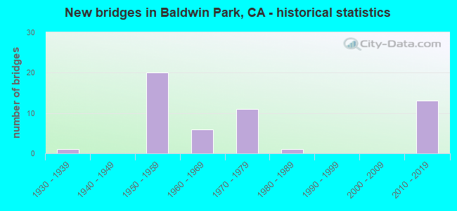
- New bridges - historical statistics
- 11930-1939
- 201950-1959
- 61960-1969
- 111970-1979
- 11980-1989
- 132010-2019
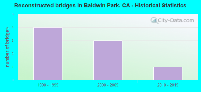
- Reconstructed bridges - Historical Statistics
- 41990-1999
- 32000-2009
- 12010-2019
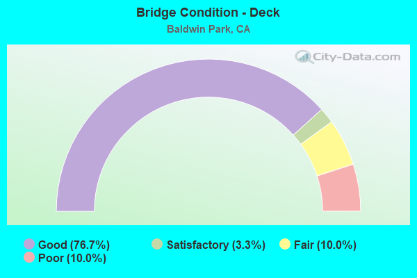
- Bridge Condition - Deck
- 76.7%Good
- 3.3%Satisfactory
- 10.0%Fair
- 10.0%Poor
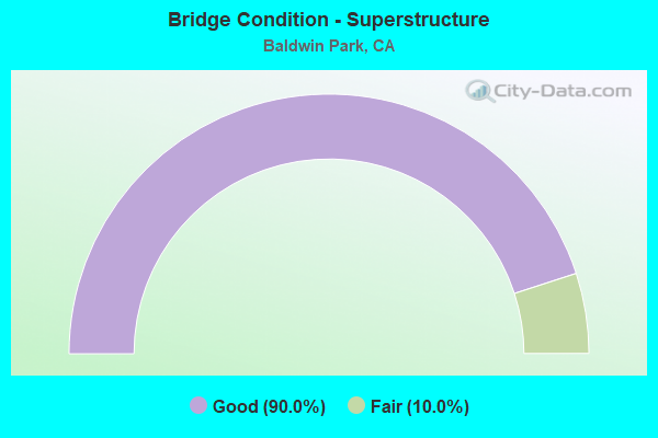
- Bridge Condition - Superstructure
- 90.0%Good
- 10.0%Fair
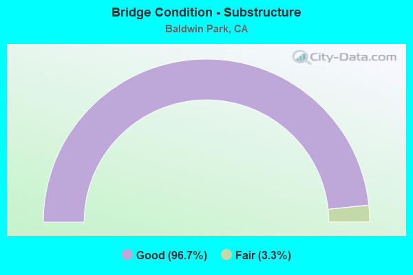
- Bridge Condition - Substructure
- 96.7%Good
- 3.3%Fair
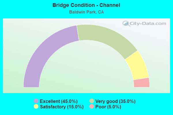
- Bridge Condition - Channel
- 45.0%Excellent
- 35.0%Very good
- 15.0%Satisfactory
- 5.0%Poor
Find on map >> Show street view
Structure Number: 53 0109L, Location: 07-LA-010-30.84-BWP (Lat: 34.065028, Lng: -118.002967), Route carried "on" structure: Interstate 10, Year Built: 1933, Year Reconstructed: 2002, Status: Open, Structure Length: 23.10m (75.79ft), Average Daily Traffic: 116,500 (year 2009), Truck Traffic: 6%, Average Future Daily Traffic: 152,739 (year 2037), Design Load: HS 20, Features Intersected: SAN GABRIEL RIVER
Minimum Vertical Clearance: 30+ m (98+ ft), Kilometerpoint: 30.840, Lanes on structure: 6, Base Highway Network: Yes (, Subroute: 1), Owner: State Highway Agency, Approaching Roadway Width: 30.5m (100.1ft), Skew: 2 degrees, Material/Design: Concrete continuous, Design/Construction: Tee Beam, Number Of Spans In Main Unit: 13, Length of Maximum Span: 19.8m (65.0ft), Curb-To-Curb Width: 30.5m (100.1ft), Out-to-Out Width: 31.4m (103.0ft)
Condition: Deck: Good, Superstructure: Good, Substructure: Good, Channel: Very good, Operating Rating: 59.8 metric tons, Method Used To Determine Operating Rating: Load Factor (LF), Inventory Rating: 35.4 metric tons, Method Used To Determine Inventory Rating: Load Factor (LF), Structural Evaluation: Better than present minimum criteria, Deck Geometry: Superior to present desirable criteria, Waterway Adequacy: Equal to present desirable criteria, Approach Roadway Alignment: Superior to present desirable criteria, Designated Inspection Frequency: Every 48 months, Inspection Date: March 2019, Deck Structure Type: Concrete Cast-file-Place, Wearing Surface/Protective System: Wearing Surface: Bituminous
Find on map >> Show street view
Structure Number: 53 0109R, Location: 07-LA-010-30.84-BWP (Lat: 34.064111, Lng: -118.005539), Route carried "on" structure: Interstate 10, Year Built: 1956, Year Reconstructed: 2004, Status: Open, Structure Length: 20.00m (65.62ft), Average Daily Traffic: 116,500 (year 2017), Truck Traffic: 6%, Average Future Daily Traffic: 152,739 (year 2037), Design Load: HS 20, Features Intersected: SAN GABRIEL RIVER
Minimum Vertical Clearance: 30+ m (98+ ft), Kilometerpoint: 30.840, Lanes on structure: 6, Base Highway Network: Yes (, Subroute: 1), Owner: State Highway Agency, Approaching Roadway Width: 28.8m (94.5ft), Skew: 2 degrees, Material/Design: Concrete continuous, Design/Construction: Tee Beam, Number Of Spans In Main Unit: 10, Length of Maximum Span: 19.8m (65.0ft), Curb-To-Curb Width: 28.8m (94.5ft), Out-to-Out Width: 50.3m (165.0ft)
Condition: Deck: Good, Superstructure: Good, Substructure: Good, Channel: Very good, Operating Rating: 24.9 metric tons, Method Used To Determine Operating Rating: Load and Resistance Factor Rating (LRFR) rating reported by rating factor(RF) method using HL-93 loadings, Inventory Rating: 17.8 metric tons, Method Used To Determine Inventory Rating: Load and Resistance Factor Rating (LRFR) rating reported by rating factor(RF) method using HL-93 loadings, Structural Evaluation: Meets minimum limits, Deck Geometry: Better than present minimum criteria, Waterway Adequacy: Equal to present desirable criteria, Approach Roadway Alignment: Superior to present desirable criteria, Designated Inspection Frequency: Every 48 months, Inspection Date: March 2019, Deck Structure Type: Concrete Cast-file-Place
Find on map >> Show street view
Structure Number: 53 0112, Location: 07-LA-010-32.93-BWP (Lat: 34.068919, Lng: -117.969839), Route carried "on" structure: Interstate 10, Year Built: 1955, Year Reconstructed: 2012, Status: Open, Structure Length: 3.62m (11.88ft), Average Daily Traffic: 209,000 (year 2012), Average Future Daily Traffic: 273,880 (year 2038), Design Load: HS 20, Features Intersected: BIG DALTON WASH
Minimum Vertical Clearance: 30+ m (98+ ft), Kilometerpoint: 32.930, Lanes on structure: 8, Base Highway Network: Yes (, Subroute: 1), Owner: State Highway Agency, Approaching Roadway Width: 48.0m (157.5ft), Skew: 35 degrees, Material/Design: Concrete, Design/Construction: Box Beam or Girders - Multiple, Number Of Spans In Main Unit: 1, Length of Maximum Span: 36.2m (118.8ft), Curb-To-Curb Width: 48.0m (157.5ft), Out-to-Out Width: 49.8m (163.4ft)
Condition: Deck: Good, Superstructure: Good, Substructure: Good, Channel: Very good, Operating Rating: 99.8 metric tons, Method Used To Determine Operating Rating: Load Factor (LF), Inventory Rating: 76.8 metric tons, Method Used To Determine Inventory Rating: Load Factor (LF), Structural Evaluation: Better than present minimum criteria, Deck Geometry: Superior to present desirable criteria, Waterway Adequacy: Equal to present desirable criteria, Approach Roadway Alignment: Superior to present desirable criteria, Designated Inspection Frequency: Every 24 months, Inspection Date: June 2021, Deck Structure Type: Concrete Cast-file-Place
Find on map >> Show street view
Structure Number: 53 0665, Location: 07-LA-010-32.66-BWP (Lat: 34.068342, Lng: -117.973956), Route carried "on" structure: Interstate 10, Year Built: 1956, Year Reconstructed: 2013, Status: Open, Structure Length: 2.71m (8.89ft), Average Daily Traffic: 209,000 (year 2012), Average Future Daily Traffic: 273,880 (year 2040), Design Load: HS 20, Features Intersected: FRANCISQUITO AVE
Minimum Vertical Clearance: 30+ m (98+ ft), Kilometerpoint: 32.660, Lanes on structure: 13, Lanes under structure: 4, Base Highway Network: Yes (, Subroute: 1), Owner: State Highway Agency, Approaching Roadway Width: 58.9m (193.2ft), Skew: 34 degrees, Material/Design: Concrete, Design/Construction: Box Beam or Girders - Multiple, Number Of Spans In Main Unit: 1, Length of Maximum Span: 26.9m (88.3ft), Curb-To-Curb Width: 58.9m (193.2ft), Out-to-Out Width: 60.4m (198.2ft)
Condition: Deck: Good, Superstructure: Good, Substructure: Good, Operating Rating: 98.8 metric tons, Method Used To Determine Operating Rating: Load Factor (LF), Inventory Rating: 59.3 metric tons, Method Used To Determine Inventory Rating: Load Factor (LF), Structural Evaluation: Better than present minimum criteria, Deck Geometry: Superior to present desirable criteria, Underclear: Meets minimum limits, Approach Roadway Alignment: Superior to present desirable criteria, Designated Inspection Frequency: Every 24 months, Inspection Date: June 2021, Deck Structure Type: Concrete Cast-file-Place
Find on map >> Show street view
Structure Number: 53 0666, Location: 07-LA-010-33.35-BWP (Lat: 34.069872, Lng: -117.962525), Route carried "on" structure: Interstate 10, Year Built: 1956, Year Reconstructed: 2019, Status: Open, Structure Length: 3.28m (10.76ft), Average Daily Traffic: 209,000 (year 2012), Average Future Daily Traffic: 373,880 (year 2040), Design Load: HS 20, Features Intersected: PUENTE AVE
Minimum Vertical Clearance: 30+ m (98+ ft), Kilometerpoint: 33.350, Lanes on structure: 10, Lanes under structure: 4, Base Highway Network: Yes (, Subroute: 1), Owner: State Highway Agency, Approaching Roadway Width: 55.5m (182.1ft), Skew: 35 degrees, Material/Design: Concrete, Design/Construction: Box Beam or Girders - Multiple, Number Of Spans In Main Unit: 1, Length of Maximum Span: 30.6m (100.4ft), Curb-To-Curb Width: 56.2m (184.4ft), Out-to-Out Width: 57.7m (189.3ft)
Condition: Deck: Good, Superstructure: Good, Substructure: Good, Operating Rating: 94.9 metric tons, Method Used To Determine Operating Rating: Load Factor (LF), Inventory Rating: 32.4 metric tons, Method Used To Determine Inventory Rating: Load Factor (LF), Structural Evaluation: Better than present minimum criteria, Deck Geometry: Superior to present desirable criteria, Underclear: Meets minimum limits, Approach Roadway Alignment: Superior to present desirable criteria, Designated Inspection Frequency: Every 24 months, Inspection Date: June 2021, Deck Structure Type: Concrete Cast-file-Place
Find on map >> Show street view
Structure Number: 53 0882, Location: 07-LA-010-31.11-BWP (Lat: 34.064756, Lng: -118.000847), Route carried "on" structure: Interstate 10, Year Built: 1956, Year Reconstructed: 2013, Status: Open, Structure Length: 2.01m (6.59ft), Average Daily Traffic: 233,000 (year 2011), Truck Traffic: 6%, Average Future Daily Traffic: 311,639 (year 2043), Design Load: HS 20, Features Intersected: W10-S605 RAMP
Minimum Vertical Clearance: 30+ m (98+ ft), Kilometerpoint: 31.110, Lanes on structure: 11, Lanes under structure: 2, Base Highway Network: Yes (, Subroute: 1), Owner: State Highway Agency, Approaching Roadway Width: 57.5m (188.6ft), Skew: 30 degrees, Material/Design: Concrete, Design/Construction: Box Beam or Girders - Multiple, Number Of Spans In Main Unit: 1, Length of Maximum Span: 20.1m (65.9ft), Curb-To-Curb Width: 57.5m (188.6ft), Out-to-Out Width: 59.1m (193.9ft)
Condition: Deck: Good, Superstructure: Fair, Substructure: Good, Operating Rating: 38.9 metric tons, Method Used To Determine Operating Rating: Load and Resistance Factor Rating (LRFR) rating reported by rating factor(RF) method using HL-93 loadings, Inventory Rating: 30.1 metric tons, Method Used To Determine Inventory Rating: Load and Resistance Factor Rating (LRFR) rating reported by rating factor(RF) method using HL-93 loadings, Structural Evaluation: Somewhat better than minimum adequacy, Deck Geometry: Superior to present desirable criteria, Underclear: Meets minimum limits, Approach Roadway Alignment: Superior to present desirable criteria, Designated Inspection Frequency: Every 24 months, Inspection Date: March 2021, Deck Structure Type: Concrete Cast-file-Place
Find on map >> Show street view
Structure Number: 53 1321M, Location: 07-LA-010-32.85-BWP (Lat: 34.068783, Lng: -117.970786), Route carried "on" structure: Interstate 10, Year Built: 1956, Status: Open, Structure Length: 0.85m (2.79ft), Average Daily Traffic: 209,000 (year 2012), Average Future Daily Traffic: 271,477 (year 2040), Features Intersected: VINELAND ST STORM DRN
Minimum Vertical Clearance: 30+ m (98+ ft), Kilometerpoint: 32.850, Lanes on structure: 10, Base Highway Network: Yes (, Subroute: 1), Owner: State Highway Agency, Approaching Roadway Width: 47.5m (155.8ft), Skew: 31 degrees, Material/Design: Concrete, Design/Construction: Culvert, Number Of Spans In Main Unit: 4, Length of Maximum Span: 2.1m (6.9ft), Curb-To-Curb Width: 47.5m (155.8ft), Out-to-Out Width: 49.2m (161.4ft)
Condition: Channel: Very good, Culverts: Good, Operating Rating: 54.1 metric tons, Method Used To Determine Operating Rating: Field evaluation and documented engineering judgment, Inventory Rating: 32.4 metric tons, Method Used To Determine Inventory Rating: Field evaluation and documented engineering judgment, Structural Evaluation: Better than present minimum criteria, Deck Geometry: Superior to present desirable criteria, Waterway Adequacy: Equal to present desirable criteria, Approach Roadway Alignment: Equal to present desirable criteria, Designated Inspection Frequency: Every 24 months, Inspection Date: August 2021
Find on map >> Show street view
Structure Number: 53 1322M, Location: 07-LA-010-33.05-BWP (Lat: 34.069161, Lng: -117.967894), Route carried "on" structure: Interstate 10, Year Built: 1956, Status: Open, Structure Length: 1.07m (3.51ft), Average Daily Traffic: 209,000 (year 2012), Average Future Daily Traffic: 271,477 (year 2040), Features Intersected: W BIG DALTON AVE STM DRN
Minimum Vertical Clearance: 30+ m (98+ ft), Kilometerpoint: 33.050, Lanes on structure: 8, Base Highway Network: Yes (, Subroute: 1), Owner: State Highway Agency, Approaching Roadway Width: 48.1m (157.8ft), Skew: 35 degrees, Material/Design: Concrete, Design/Construction: Culvert, Number Of Spans In Main Unit: 4, Length of Maximum Span: 2.7m (8.9ft), Curb-To-Curb Width: 48.1m (157.8ft), Out-to-Out Width: 49.9m (163.7ft)
Condition: Channel: Very good, Culverts: Good, Operating Rating: 54.1 metric tons, Method Used To Determine Operating Rating: Field evaluation and documented engineering judgment, Inventory Rating: 32.4 metric tons, Method Used To Determine Inventory Rating: Field evaluation and documented engineering judgment, Structural Evaluation: Better than present minimum criteria, Deck Geometry: Superior to present desirable criteria, Waterway Adequacy: Equal to present desirable criteria, Approach Roadway Alignment: Superior to present desirable criteria, Designated Inspection Frequency: Every 24 months, Inspection Date: August 2021
Find on map >> Show street view
Structure Number: 53 1323M, Location: 07-LA-010-33.09-BWP (Lat: 34.069267, Lng: -117.967294), Route carried "on" structure: Interstate 10, Year Built: 1956, Status: Open, Structure Length: 0.88m (2.89ft), Average Daily Traffic: 209,000 (year 2012), Truck Traffic: 10%, Average Future Daily Traffic: 271,477 (year 2040), Features Intersected: BIG DALTON AVE STORM DRN
Minimum Vertical Clearance: 30+ m (98+ ft), Kilometerpoint: 33.090, Lanes on structure: 8, Base Highway Network: Yes (, Subroute: 1), Owner: State Highway Agency, Approaching Roadway Width: 48.1m (157.8ft), Skew: 35 degrees, Material/Design: Concrete, Design/Construction: Culvert, Number Of Spans In Main Unit: 4, Length of Maximum Span: 2.1m (6.9ft), Curb-To-Curb Width: 48.1m (157.8ft), Out-to-Out Width: 50.0m (164.0ft)
Condition: Channel: Very good, Culverts: Good, Operating Rating: 54.1 metric tons, Method Used To Determine Operating Rating: Field evaluation and documented engineering judgment, Inventory Rating: 32.4 metric tons, Method Used To Determine Inventory Rating: Field evaluation and documented engineering judgment, Structural Evaluation: Better than present minimum criteria, Deck Geometry: Superior to present desirable criteria, Waterway Adequacy: Equal to present desirable criteria, Approach Roadway Alignment: Superior to present desirable criteria, Designated Inspection Frequency: Every 24 months, Inspection Date: August 2021
Find on map >> Show street view
Structure Number: 53 1343, Location: 07-LA-605-R19.85-BWP (Lat: 34.060328, Lng: -118.000911), Route carried "on" structure: Interstate 605, Year Built: 1957, Year Reconstructed: 1995, Status: Open, Structure Length: 14.22m (46.65ft), Average Daily Traffic: 237,090 (year 2015), Truck Traffic: 12%, Average Future Daily Traffic: 274,219 (year 2040), Design Load: HS 20, Features Intersected: WALNUT CREEK
Minimum Vertical Clearance: 30+ m (98+ ft), Kilometerpoint: 19.850, Lanes on structure: 12, Base Highway Network: Yes (Inventory Route: 6, Subroute: 1), Owner: State Highway Agency, Approaching Roadway Width: 48.4m (158.8ft), Skew: 32 degrees, Material/Design: Concrete continuous, Design/Construction: Tee Beam, Number Of Spans In Main Unit: 7, Length of Maximum Span: 21.9m (71.9ft), Curb-To-Curb Width: 48.4m (158.8ft), Out-to-Out Width: 52.0m (170.6ft)
Condition: Deck: Good, Superstructure: Good, Substructure: Good, Channel: Very good, Operating Rating: 71.6 metric tons, Method Used To Determine Operating Rating: Load Factor (LF), Inventory Rating: 43.1 metric tons, Method Used To Determine Inventory Rating: Load Factor (LF), Structural Evaluation: Better than present minimum criteria, Deck Geometry: Meets minimum limits, Waterway Adequacy: Equal to present desirable criteria, Approach Roadway Alignment: Equal to present desirable criteria, Designated Inspection Frequency: Every 24 months, Inspection Date: March 2020, Deck Structure Type: Concrete Cast-file-Place
Find on map >> Show street view
Structure Number: 53 1631, Location: 07-LA-605-R20.09-BWP (Lat: 34.063664, Lng: -118.000003), Route carried "on" structure: Interstate 605, Year Built: 1971, Status: Open, Structure Length: 3.11m (10.20ft), Average Daily Traffic: 230,000 (year 2015), Truck Traffic: 10%, Average Future Daily Traffic: 206,213 (year 2040), Design Load: HS 20, Features Intersected: S605-E10
Minimum Vertical Clearance: 30+ m (98+ ft), Kilometerpoint: 20.090, Lanes on structure: 8, Lanes under structure: 1, Base Highway Network: Yes (Inventory Route: 6, Subroute: 3), Owner: State Highway Agency, Approaching Roadway Width: 34.1m (111.9ft), Skew: 39 degrees, Material/Design: Prestressed concrete, Design/Construction: Box Beam or Girders - Multiple, Number Of Spans In Main Unit: 1, Length of Maximum Span: 31.1m (102.0ft), Curb-To-Curb Width: 34.1m (111.9ft), Out-to-Out Width: 35.4m (116.1ft)
Condition: Deck: Good, Superstructure: Good, Substructure: Good, Operating Rating: 48.6 metric tons, Method Used To Determine Operating Rating: Load and Resistance Factor Rating (LRFR) rating reported by rating factor(RF) method using HL-93 loadings, Inventory Rating: 37.6 metric tons, Method Used To Determine Inventory Rating: Load and Resistance Factor Rating (LRFR) rating reported by rating factor(RF) method using HL-93 loadings, Structural Evaluation: Better than present minimum criteria, Deck Geometry: Somewhat better than minimum adequacy, Underclear: Equal to present desirable criteria, Approach Roadway Alignment: Equal to present desirable criteria, Designated Inspection Frequency: Every 24 months, Inspection Date: March 2020, Deck Structure Type: Concrete Cast-file-Place
Find on map >> Show street view
Structure Number: 53 1631G, Location: 07-LA-605-R20.09-BWP (Lat: 34.063644, Lng: -117.999856), Route carried "on" structure: Ramp Interstate 605, Year Built: 1964, Status: Open, Structure Length: 3.18m (10.43ft), Average Daily Traffic: 23,700 (year 2015), Truck Traffic: 2%, Average Future Daily Traffic: 26,791 (year 2040), Design Load: HS 20, Features Intersected: S605-E10
Minimum Vertical Clearance: 30+ m (98+ ft), Kilometerpoint: 20.090, Lanes on structure: 1, Lanes under structure: 1, Base Highway Network: Yes (Inventory Route: 6, Subroute: 1), Owner: State Highway Agency, Approaching Roadway Width: 10.4m (34.1ft), Material/Design: Concrete continuous, Design/Construction: Tee Beam, Number Of Spans In Main Unit: 3, Length of Maximum Span: 11.5m (37.7ft), Curb or Sidewalk Widths: Left: 0.6m (2.0ft), Right: 0.0m, Curb-To-Curb Width: 10.4m (34.1ft), Out-to-Out Width: 11.7m (38.4ft)
Condition: Deck: Good, Superstructure: Good, Substructure: Good, Operating Rating: 43.7 metric tons, Method Used To Determine Operating Rating: Load and Resistance Factor Rating (LRFR) rating reported by rating factor(RF) method using HL-93 loadings, Inventory Rating: 31.1 metric tons, Method Used To Determine Inventory Rating: Load and Resistance Factor Rating (LRFR) rating reported by rating factor(RF) method using HL-93 loadings, Structural Evaluation: Better than present minimum criteria, Deck Geometry: Superior to present desirable criteria, Underclear: Better than present minimum criteria, Approach Roadway Alignment: Equal to present desirable criteria, Designated Inspection Frequency: Every 24 months, Inspection Date: March 2020, Deck Structure Type: Concrete Cast-file-Place
Find on map >> Show street view
Structure Number: 53 1632, Location: 07-LA-605-R20.17-BWP (Lat: 34.064811, Lng: -117.999978), Route carried "on" structure: Interstate 605, Year Built: 1971, Status: Open, Structure Length: 6.77m (22.21ft), Average Daily Traffic: 230,000 (year 2015), Truck Traffic: 10%, Average Future Daily Traffic: 206,213 (year 2040), Design Load: HS 20, Features Intersected: INTERSTATE 10
Minimum Vertical Clearance: 30+ m (98+ ft), Kilometerpoint: 20.170, Lanes on structure: 8, Lanes under structure: 10, Base Highway Network: Yes (Inventory Route: 6, Subroute: 3), Owner: State Highway Agency, Approaching Roadway Width: 34.2m (112.2ft), Skew: 30 degrees, Material/Design: Prestressed concrete, Design/Construction: Stringer/Multi-beam, Number Of Spans In Main Unit: 2, Length of Maximum Span: 35.7m (117.1ft), Curb-To-Curb Width: 34.2m (112.2ft), Out-to-Out Width: 35.4m (116.1ft)
Condition: Deck: Good, Superstructure: Good, Substructure: Good, Operating Rating: 43.7 metric tons, Method Used To Determine Operating Rating: Load and Resistance Factor Rating (LRFR) rating reported by rating factor(RF) method using HL-93 loadings, Inventory Rating: 20.4 metric tons, Method Used To Determine Inventory Rating: Load and Resistance Factor Rating (LRFR) rating reported by rating factor(RF) method using HL-93 loadings, Structural Evaluation: Somewhat better than minimum adequacy, Deck Geometry: Somewhat better than minimum adequacy, Underclear: High priority of corrective action, Approach Roadway Alignment: Equal to present desirable criteria, Designated Inspection Frequency: Every 24 months, Inspection Date: April 2020, Deck Structure Type: Concrete Cast-file-Place
Find on map >> Show street view
Structure Number: 53 1633, Location: 07-LA-605-20.27-BWP (Lat: 34.066339, Lng: -118.000208), Route carried "on" structure: Interstate 605, Year Built: 1971, Status: Open, Structure Length: 3.81m (12.50ft), Average Daily Traffic: 185,000 (year 2015), Truck Traffic: 7%, Average Future Daily Traffic: 173,350 (year 2040), Design Load: HS 20+Mod, Features Intersected: W10-S605 CONN
Minimum Vertical Clearance: 30+ m (98+ ft), Kilometerpoint: 20.270, Lanes on structure: 7, Lanes under structure: 2, Base Highway Network: Yes (Inventory Route: 6, Subroute: 3), Owner: State Highway Agency, Approaching Roadway Width: 34.2m (112.2ft), Skew: 39 degrees, Material/Design: Prestressed concrete, Design/Construction: Box Beam or Girders - Multiple, Number Of Spans In Main Unit: 1, Length of Maximum Span: 38.1m (125.0ft), Curb-To-Curb Width: 34.2m (112.2ft), Out-to-Out Width: 35.4m (116.1ft)
Condition: Deck: Good, Superstructure: Good, Substructure: Good, Operating Rating: 57.3 metric tons, Method Used To Determine Operating Rating: Load and Resistance Factor Rating (LRFR) rating reported by rating factor(RF) method using HL-93 loadings, Inventory Rating: 39.5 metric tons, Method Used To Determine Inventory Rating: Load and Resistance Factor Rating (LRFR) rating reported by rating factor(RF) method using HL-93 loadings, Structural Evaluation: Better than present minimum criteria, Deck Geometry: Superior to present desirable criteria, Underclear: Equal to present desirable criteria, Approach Roadway Alignment: Superior to present desirable criteria, Designated Inspection Frequency: Every 24 months, Inspection Date: April 2020, Deck Structure Type: Concrete Cast-file-Place
Find on map >> Show street view
Structure Number: 53 1633G, Location: 07-LA-010-31.18-BWP (Lat: 34.066389, Lng: -118.000069), Route carried "on" structure: Ramp Interstate 10, Year Built: 1964, Status: Open, Structure Length: 3.52m (11.55ft), Average Daily Traffic: 13,300 (year 2011), Truck Traffic: 2%, Average Future Daily Traffic: 13,842 (year 2043), Design Load: HS 20+Mod, Features Intersected: W10-S605 CONNECTOR RAMP
Minimum Vertical Clearance: 30+ m (98+ ft), Kilometerpoint: 31.180, Lanes on structure: 1, Lanes under structure: 2, Owner: State Highway Agency, Approaching Roadway Width: 10.4m (34.1ft), Material/Design: Concrete continuous, Design/Construction: Tee Beam, Number Of Spans In Main Unit: 3, Length of Maximum Span: 14.1m (46.3ft), Curb or Sidewalk Widths: Left: 0.6m (2.0ft), Right: 0.0m, Curb-To-Curb Width: 10.4m (34.1ft), Out-to-Out Width: 11.7m (38.4ft)
Condition: Deck: Fair, Superstructure: Good, Substructure: Good, Operating Rating: 33.7 metric tons, Method Used To Determine Operating Rating: Load and Resistance Factor Rating (LRFR) rating reported by rating factor(RF) method using HL-93 loadings, Inventory Rating: 26.2 metric tons, Method Used To Determine Inventory Rating: Load and Resistance Factor Rating (LRFR) rating reported by rating factor(RF) method using HL-93 loadings, Structural Evaluation: Equal to present minimum criteria, Deck Geometry: Superior to present desirable criteria, Underclear: Equal to present desirable criteria, Approach Roadway Alignment: Superior to present desirable criteria, Designated Inspection Frequency: Every 24 months, Inspection Date: March 2021, Deck Structure Type: Concrete Cast-file-Place
Find on map >> Show street view
Structure Number: 53 208, Location: 07-LA-060-R28.04-POM (Lat: 34.024328, Lng: -117.771194), Route carried "on" structure: City street L647, Year Built: 1970, Year Reconstructed: 1995, Status: Open, Structure Length: 9.04m (29.66ft), Average Daily Traffic: 15,300 (year 2015), Truck Traffic: 4%, Average Future Daily Traffic: 23,049 (year 2040), Design Load: HS 20+Mod, Features Intersected: ROUTE 60, Facility Carried by Structure: PHILLIPS RANCH RD
Minimum Vertical Clearance: 30+ m (98+ ft), Kilometerpoint: 0.000, Lanes on structure: 6, Lanes under structure: 12, Owner: State Highway Agency, Approaching Roadway Width: 25.3m (83.0ft), Skew: 9 degrees, Material/Design: Prestressed concrete continuous, Design/Construction: Box Beam or Girders - Single/Spread, Number Of Spans In Main Unit: 2, Length of Maximum Span: 45.7m (149.9ft), Curb or Sidewalk Widths: Left: 2.3m (7.5ft), Right: 1.2m (3.9ft), Curb-To-Curb Width: 25.3m (83.0ft), Out-to-Out Width: 30.0m (98.4ft)
Condition: Deck: Good, Superstructure: Good, Substructure: Good, Operating Rating: 96.6 metric tons, Method Used To Determine Operating Rating: Load Factor (LF), Inventory Rating: 32.4 metric tons, Method Used To Determine Inventory Rating: Load Factor (LF), Structural Evaluation: Better than present minimum criteria, Deck Geometry: Somewhat better than minimum adequacy, Underclear: Better than present minimum criteria, Approach Roadway Alignment: Superior to present desirable criteria, Designated Inspection Frequency: Every 24 months, Inspection Date: Febuary 2021, Deck Structure Type: Concrete Cast-file-Place
Find on map >> Show street view
Structure Number: 53 2086, Location: 07-LA-605-21.07-BWP (Lat: 34.077431, Lng: -117.998428), Route carried "on" structure: City street L371, Year Built: 1971, Status: Open, Structure Length: 6.28m (20.60ft), Average Daily Traffic: 20,300 (year 2015), Truck Traffic: 2%, Average Future Daily Traffic: 25,564 (year 2040), Design Load: HS 20, Features Intersected: INTERSTATE 605, Facility Carried by Structure: WEST RAMONA BLVD
Minimum Vertical Clearance: 30+ m (98+ ft), Kilometerpoint: 0.000, Lanes on structure: 6, Lanes under structure: 10, Owner: State Highway Agency, Approaching Roadway Width: 24.0m (78.7ft), Skew: 22 degrees, Material/Design: Prestressed concrete, Design/Construction: Tee Beam, Number Of Spans In Main Unit: 2, Length of Maximum Span: 31.4m (103.0ft), Curb or Sidewalk Widths: Left: 2.3m (7.5ft), Right: 2.3m (7.5ft), Curb-To-Curb Width: 24.0m (78.7ft), Out-to-Out Width: 30.9m (101.4ft)
Condition: Deck: Good, Superstructure: Good, Substructure: Good, Operating Rating: 52.5 metric tons, Method Used To Determine Operating Rating: Load and Resistance Factor Rating (LRFR) rating reported by rating factor(RF) method using HL-93 loadings, Inventory Rating: 30.1 metric tons, Method Used To Determine Inventory Rating: Load and Resistance Factor Rating (LRFR) rating reported by rating factor(RF) method using HL-93 loadings, Structural Evaluation: Better than present minimum criteria, Deck Geometry: Somewhat better than minimum adequacy, Underclear: Meets minimum limits, Approach Roadway Alignment: Superior to present desirable criteria, Designated Inspection Frequency: Every 24 months, Inspection Date: April 2020, Deck Structure Type: Concrete Cast-file-Place
Find on map >> Show street view
Structure Number: 53 3004, Location: 07-LA-010-31.54-BWP (Lat: 34.065819, Lng: -117.993408), Route carried "on" structure: City street , Year Built: 2012, Status: Open, Structure Length: 8.95m (29.36ft), Average Daily Traffic: 207,800 (year 2017), Truck Traffic: 6%, Average Future Daily Traffic: 208,000 (year 2039), Design Load: HL 93, Features Intersected: INTERSTATE 10, Facility Carried by Structure: AMAR RD
Minimum Vertical Clearance: 30+ m (98+ ft), Kilometerpoint: 0.000, Lanes on structure: 2, Lanes under structure: 12, Owner: State Highway Agency, Approaching Roadway Width: 9.6m (31.5ft), Material/Design: Prestressed concrete, Design/Construction: Box Beam or Girders - Single/Spread, Number Of Spans In Main Unit: 3, Length of Maximum Span: 38.3m (125.7ft), Curb or Sidewalk Widths: Left: 1.5m (4.9ft), Right: 0.0m, Curb-To-Curb Width: 9.6m (31.5ft), Out-to-Out Width: 11.8m (38.7ft)
Condition: Deck: Good, Superstructure: Good, Substructure: Good, Operating Rating: 42.1 metric tons, Method Used To Determine Operating Rating: Assigned ratings based on Load and Resistance Factor Design (LRFD) reported by rating factor (RF) using HL93 loadings, Inventory Rating: 32.4 metric tons, Method Used To Determine Inventory Rating: Assigned ratings based on Load and Resistance Factor Design (LRFD) reported by rating factor (RF) using HL93 loadings, Structural Evaluation: Better than present minimum criteria, Deck Geometry: Meets minimum limits, Underclear: High priority of corrective action, Approach Roadway Alignment: Equal to present desirable criteria, Designated Inspection Frequency: Every 24 months, Inspection Date: March 2021, Deck Structure Type: Concrete Cast-file-Place
Find on map >> Show street view
Structure Number: 53 302, Location: 07-LA-071-1.60 (Lat: 34.053675, Lng: -117.781019), Route carried "on" structure: Alternate City street , Year Built: 2011, Status: Open, Structure Length: 7.50m (24.61ft), Average Daily Traffic: 16,400 (year 2012), Truck Traffic: 3%, Average Future Daily Traffic: 20,100 (year 2040), Design Load: HS 20+Mod, Features Intersected: SR 71, Facility Carried by Structure: MISSION BLVD
Minimum Vertical Clearance: 30+ m (98+ ft), Kilometerpoint: 0.000, Lanes on structure: 8, Lanes under structure: 4, Owner: State Highway Agency, Approaching Roadway Width: 26.5m (86.9ft), Skew: 3 degrees, Material/Design: Prestressed concrete continuous, Design/Construction: Girder and Floorbeam System, Number Of Spans In Main Unit: 2, Length of Maximum Span: 37.7m (123.7ft), Curb or Sidewalk Widths: Left: 1.8m (5.9ft), Right: 1.8m (5.9ft), Curb-To-Curb Width: 33.0m (108.3ft), Out-to-Out Width: 37.2m (122.0ft)
Condition: Deck: Fair, Superstructure: Good, Substructure: Good, Operating Rating: 71.6 metric tons, Method Used To Determine Operating Rating: Load Factor (LF), Inventory Rating: 43.1 metric tons, Method Used To Determine Inventory Rating: Load Factor (LF), Structural Evaluation: Better than present minimum criteria, Deck Geometry: Somewhat better than minimum adequacy, Underclear: Meets minimum limits, Approach Roadway Alignment: Equal to present desirable criteria, Designated Inspection Frequency: Every 24 months, Inspection Date: December 2020, Deck Structure Type: Concrete Cast-file-Place
Find on map >> Show street view
Structure Number: 53 3026, Location: 07-LA-010-32.22-BWP (Lat: 34.066958, Lng: -117.982247), Route carried "on" structure: City street , Year Built: 2012, Status: Open, Structure Length: 14.58m (47.83ft), Average Daily Traffic: 216,600 (year 2011), Truck Traffic: 6%, Average Future Daily Traffic: 221,172 (year 2043), Design Load: HL 93, Features Intersected: INTERSTATE 10, Facility Carried by Structure: BALDWIN PARK BLVD
Minimum Vertical Clearance: 30+ m (98+ ft), Kilometerpoint: 0.000, Lanes on structure: 4, Lanes under structure: 12, Owner: State Highway Agency, Approaching Roadway Width: 18.1m (59.4ft), Skew: 4 degrees, Material/Design: Steel continuous, Design/Construction: Stringer/Multi-beam, Number Of Spans In Main Unit: 4, Length of Maximum Span: 46.6m (152.9ft), Curb or Sidewalk Widths: Left: 1.5m (4.9ft), Right: 1.5m (4.9ft), Curb-To-Curb Width: 18.1m (59.4ft), Out-to-Out Width: 21.8m (71.5ft)
Condition: Deck: Good, Superstructure: Good, Substructure: Good, Operating Rating: 42.1 metric tons, Method Used To Determine Operating Rating: Assigned ratings based on Load and Resistance Factor Design (LRFD) reported by rating factor (RF) using HL93 loadings, Inventory Rating: 32.4 metric tons, Method Used To Determine Inventory Rating: Assigned ratings based on Load and Resistance Factor Design (LRFD) reported by rating factor (RF) using HL93 loadings, Structural Evaluation: Better than present minimum criteria, Deck Geometry: Somewhat better than minimum adequacy, Underclear: High priority of corrective action, Approach Roadway Alignment: Equal to present desirable criteria, Designated Inspection Frequency: Every 24 months, Inspection Date: March 2021, Deck Structure Type: Concrete Cast-file-Place
Find on map >> Show street view
Structure Number: 53 3027H, Location: 07-LA-605-R20.17-BWP (Lat: 34.064856, Lng: -117.999775), Route carried "on" structure: Ramp Interstate 605, Year Built: 2013, Status: Open, Structure Length: 6.30m (20.67ft), Average Daily Traffic: 23,700 (year 2015), Truck Traffic: 2%, Average Future Daily Traffic: 23,900 (year 2040), Design Load: HL 93, Features Intersected: INTERSTATE 10
Minimum Vertical Clearance: 30+ m (98+ ft), Kilometerpoint: 20.170, Lanes on structure: 2, Lanes under structure: 12, Owner: State Highway Agency, Approaching Roadway Width: 17.8m (58.4ft), Material/Design: Prestressed concrete continuous, Design/Construction: Box Beam or Girders - Multiple, Number Of Spans In Main Unit: 2, Length of Maximum Span: 33.3m (109.3ft), Curb-To-Curb Width: 17.8m (58.4ft), Out-to-Out Width: 18.7m (61.4ft)
Condition: Deck: Good, Superstructure: Good, Substructure: Good, Operating Rating: 42.1 metric tons, Method Used To Determine Operating Rating: Assigned ratings based on Load and Resistance Factor Design (LRFD) reported by rating factor (RF) using HL93 loadings, Inventory Rating: 32.4 metric tons, Method Used To Determine Inventory Rating: Assigned ratings based on Load and Resistance Factor Design (LRFD) reported by rating factor (RF) using HL93 loadings, Structural Evaluation: Better than present minimum criteria, Deck Geometry: Superior to present desirable criteria, Underclear: Meets minimum limits, Approach Roadway Alignment: Equal to present desirable criteria, Designated Inspection Frequency: Every 24 months, Inspection Date: April 2020, Deck Structure Type: Concrete Cast-file-Place
Find on map >> Show street view
Structure Number: 53 3047F, Location: 07-LA-605-20.36-BWP (Lat: 34.067569, Lng: -118.001128), Route carried "on" structure: Ramp Interstate 605, Year Built: 2015, Status: Open, Structure Length: 102.53m (336.38ft), Average Daily Traffic: 23,700 (year 2015), Truck Traffic: 12%, Average Future Daily Traffic: 30,707 (year 2040), Design Load: HL 93, Features Intersected: INTERSTATE 10
Minimum Vertical Clearance: 30+ m (98+ ft), Kilometerpoint: 20.360, Lanes on structure: 1, Lanes under structure: 22, Owner: State Highway Agency, Approaching Roadway Width: 8.2m (26.9ft), Material/Design: Prestressed concrete continuous, Design/Construction: Box Beam or Girders - Multiple, Number Of Spans In Main Unit: 17, Length of Maximum Span: 69.5m (228.0ft), Curb-To-Curb Width: 8.2m (26.9ft), Out-to-Out Width: 9.1m (29.9ft)
Condition: Deck: Good, Superstructure: Good, Substructure: Good, Operating Rating: 42.1 metric tons, Method Used To Determine Operating Rating: Assigned ratings based on Load and Resistance Factor Design (LRFD) reported by rating factor (RF) using HL93 loadings, Inventory Rating: 32.4 metric tons, Method Used To Determine Inventory Rating: Assigned ratings based on Load and Resistance Factor Design (LRFD) reported by rating factor (RF) using HL93 loadings, Structural Evaluation: Better than present minimum criteria, Deck Geometry: Superior to present desirable criteria, Underclear: High priority of corrective action, Approach Roadway Alignment: Equal to present desirable criteria, Designated Inspection Frequency: Every 24 months, Inspection Date: April 2020, Deck Structure Type: Concrete Cast-file-Place
Find on map >> Show street view
Structure Number: 53C0157, Location: 0.1MI W/O I-605 FWY (Lat: 34.076831, Lng: -118.001289), Route carried "on" structure: City street L371, Year Built: 1961, Status: Open, Structure Length: 15.85m (52.00ft), Average Daily Traffic: 38,792 (year 2012), Truck Traffic: 2%, Average Future Daily Traffic: 46,550 (year 2041), Design Load: HS 20, Features Intersected: SAN GABRIEL RIV, Facility Carried by Structure: RAMONA BLVD
Minimum Vertical Clearance: 7.62m (25.00ft), Kilometerpoint: 0.000, Lanes on structure: 4, Owner: City or Municipal Highway Agency, Approaching Roadway Width: 15.8m (51.8ft), Skew: 2 degrees, Material/Design: Concrete continuous, Design/Construction: Slab, Number Of Spans In Main Unit: 13, Length of Maximum Span: 20.1m (65.9ft), Curb or Sidewalk Widths: Left: 0.0m, Right: 1.4m (4.6ft), Curb-To-Curb Width: 16.0m (52.5ft), Out-to-Out Width: 18.3m (60.0ft)
Condition: Deck: Good, Superstructure: Good, Substructure: Good, Channel: Satisfactory, Operating Rating: 59.6 metric tons, Method Used To Determine Operating Rating: Load Factor (LF), Inventory Rating: 35.6 metric tons, Method Used To Determine Inventory Rating: Load Factor (LF), Structural Evaluation: Better than present minimum criteria, Deck Geometry: Meets minimum limits, Waterway Adequacy: Equal to present minimum criteria, Approach Roadway Alignment: Equal to present desirable criteria, Designated Inspection Frequency: Every 48 months, Inspection Date: July 2021, Deck Structure Type: Concrete Cast-file-Place, Wearing Surface/Protective System: Wearing Surface: Monolithic Concrete
Find on map >> Show street view
Structure Number: 53C0336, Location: 0.3MI S/O I-10 FWY (Lat: 34.066178, Lng: -117.966150), Route carried "on" structure: City street Q914, Year Built: 1961, Status: Open, Structure Length: 1.65m (5.41ft), Average Daily Traffic: 23,730 (year 2012), Truck Traffic: 2%, Average Future Daily Traffic: 28,476 (year 2041), Design Load: HS 20+Mod, Features Intersected: WALNUT CRK, Facility Carried by Structure: PUENTE AVE
Minimum Vertical Clearance: 30.47m (99.97ft), Kilometerpoint: 0.000, Lanes on structure: 4, Owner: City or Municipal Highway Agency, Approaching Roadway Width: 20.0m (65.6ft), Skew: 21 degrees, Material/Design: Concrete, Design/Construction: Tee Beam, Number Of Spans In Main Unit: 1, Length of Maximum Span: 15.2m (49.9ft), Curb or Sidewalk Widths: Left: 1.2m (3.9ft), Right: 1.2m (3.9ft), Curb-To-Curb Width: 14.6m (47.9ft), Out-to-Out Width: 22.6m (74.1ft)
Condition: Deck: Poor, Superstructure: Good, Substructure: Fair, Channel: Excellent, Operating Rating: 44.4 metric tons, Method Used To Determine Operating Rating: Load Factor (LF), Inventory Rating: 26.9 metric tons, Method Used To Determine Inventory Rating: Load Factor (LF), Structural Evaluation: Somewhat better than minimum adequacy, Deck Geometry: High priority of replacement, Waterway Adequacy: Superior to present desirable criteria, Approach Roadway Alignment: Equal to present desirable criteria, Designated Inspection Frequency: Every 24 months, Inspection Date: July 2021, Bridge Improvement Cost: $372,000, Roadway Improvement Cost: $165,000, Total Project Cost: $1,390,000 ( Estimate for 2017), Deck Structure Type: Concrete Cast-file-Place, Wearing Surface/Protective System: Wearing Surface: Monolithic Concrete
Find on map >> Show street view
Structure Number: 53C0661, Location: 0.5MI W/O PUENTE AVE (Lat: 34.069417, Lng: -117.969342), Route carried "on" structure: City street Q939, Year Built: 1956, Status: Open, Structure Length: 3.62m (11.88ft), Average Daily Traffic: 11,433 (year 2012), Truck Traffic: 2%, Average Future Daily Traffic: 13,148 (year 2041), Design Load: HS 20, Features Intersected: BIG DALTON WASH, Facility Carried by Structure: GARVEY AVE
Minimum Vertical Clearance: 30.47m (99.97ft), Kilometerpoint: 0.000, Lanes on structure: 2, Owner: City or Municipal Highway Agency, Approaching Roadway Width: 9.8m (32.2ft), Skew: 4 degrees, Material/Design: Prestressed concrete, Design/Construction: Box Beam or Girders - Multiple, Number Of Spans In Main Unit: 1, Length of Maximum Span: 35.1m (115.2ft), Curb or Sidewalk Widths: Left: 1.6m (5.2ft), Right: 0.6m (2.0ft), Curb-To-Curb Width: 8.0m (26.2ft), Out-to-Out Width: 10.7m (35.1ft)
Condition: Deck: Good, Superstructure: Good, Substructure: Good, Channel: Excellent, Operating Rating: 82.6 metric tons, Method Used To Determine Operating Rating: Load Factor (LF), Inventory Rating: 49.6 metric tons, Method Used To Determine Inventory Rating: Load Factor (LF), Structural Evaluation: Better than present minimum criteria, Deck Geometry: High priority of replacement, Waterway Adequacy: Superior to present desirable criteria, Approach Roadway Alignment: Better than present minimum criteria, Designated Inspection Frequency: Every 24 months, Inspection Date: July 2021, Deck Structure Type: Concrete Cast-file-Place, Wearing Surface/Protective System: Wearing Surface: Monolithic Concrete
Find on map >> Show street view
Structure Number: 53C0662, Location: 0.1MI S/O I-10 FWY (Lat: 34.066836, Lng: -117.971592), Route carried "on" structure: City street L726, Year Built: 1958, Status: Open, Structure Length: 3.57m (11.71ft), Average Daily Traffic: 31,805 (year 2012), Truck Traffic: 3%, Average Future Daily Traffic: 38,166 (year 2041), Design Load: HS 20, Features Intersected: WALNUT CRK, Facility Carried by Structure: FRANCISQUITO AVE
Minimum Vertical Clearance: 30.47m (99.97ft), Kilometerpoint: 0.000, Lanes on structure: 4, Owner: City or Municipal Highway Agency, Approaching Roadway Width: 18.3m (60.0ft), Material/Design: Steel, Design/Construction: Stringer/Multi-beam, Number Of Spans In Main Unit: 2, Length of Maximum Span: 18.6m (61.0ft), Curb or Sidewalk Widths: Left: 1.5m (4.9ft), Right: 1.5m (4.9ft), Curb-To-Curb Width: 15.8m (51.8ft), Out-to-Out Width: 19.4m (63.6ft)
Condition: Deck: Poor, Superstructure: Fair, Substructure: Good, Channel: Excellent, Operating Rating: 37.9 metric tons, Method Used To Determine Operating Rating: Load Factor (LF), Inventory Rating: 22.7 metric tons, Method Used To Determine Inventory Rating: Load Factor (LF), Structural Evaluation: Somewhat better than minimum adequacy, Deck Geometry: Meets minimum limits, Waterway Adequacy: Superior to present desirable criteria, Approach Roadway Alignment: Equal to present desirable criteria, Designated Inspection Frequency: Every 24 months, Inspection Date: July 2021, Bridge Improvement Cost: $692,000, Roadway Improvement Cost: $342,000, Total Project Cost: $2,880,000 ( Estimate for 2017), Deck Structure Type: Concrete Cast-file-Place, Wearing Surface/Protective System: Wearing Surface: Monolithic Concrete
Find on map >> Show street view
Structure Number: 53C067, Location: 0.5MI S/O ARROW HWY (Lat: 34.100008, Lng: -117.925306), Route carried "on" structure: County highway L378, Year Built: 1959, Status: Open, Structure Length: 1.16m (3.81ft), Average Daily Traffic: 10,094 (year 2012), Truck Traffic: 2%, Average Future Daily Traffic: 11,608 (year 2041), Design Load: HS 20, Features Intersected: LITTLE DALTON WASH, Facility Carried by Structure: VINCENT AVE
Minimum Vertical Clearance: 30+ m (98+ ft), Kilometerpoint: 0.000, Lanes on structure: 4, Owner: County Highway Agency, Approaching Roadway Width: 18.3m (60.0ft), Skew: 2 degrees, Material/Design: Concrete, Design/Construction: Frame, Number Of Spans In Main Unit: 1, Length of Maximum Span: 9.1m (29.9ft), Curb or Sidewalk Widths: Left: 1.5m (4.9ft), Right: 1.5m (4.9ft), Curb-To-Curb Width: 18.4m (60.4ft), Out-to-Out Width: 21.9m (71.9ft)
Condition: Deck: Good, Superstructure: Good, Substructure: Good, Channel: Excellent, Operating Rating: 68.7 metric tons, Method Used To Determine Operating Rating: Load Factor (LF), Inventory Rating: 41.1 metric tons, Method Used To Determine Inventory Rating: Load Factor (LF), Structural Evaluation: Better than present minimum criteria, Deck Geometry: Somewhat better than minimum adequacy, Waterway Adequacy: Superior to present desirable criteria, Approach Roadway Alignment: Equal to present desirable criteria, Designated Inspection Frequency: Every 48 months, Inspection Date: October 2021, Deck Structure Type: Concrete Cast-file-Place, Wearing Surface/Protective System: Wearing Surface: Monolithic Concrete
Find on map >> Show street view
Structure Number: 53C0677, Location: 0.3MI W/O PUENTE AVE (Lat: 34.074331, Lng: -117.963978), Route carried "on" structure: City street L686, Year Built: 1959, Status: Open, Structure Length: 2.01m (6.59ft), Average Daily Traffic: 13,309 (year 2012), Truck Traffic: 1%, Average Future Daily Traffic: 15,305 (year 2041), Design Load: HS 20, Features Intersected: BIG DALTON WASH, Facility Carried by Structure: MERCED AVE
Minimum Vertical Clearance: 30+ m (98+ ft), Kilometerpoint: 0.000, Lanes on structure: 4, Owner: City or Municipal Highway Agency, Approaching Roadway Width: 19.5m (64.0ft), Material/Design: Prestressed concrete, Design/Construction: Stringer/Multi-beam, Number Of Spans In Main Unit: 1, Length of Maximum Span: 18.9m (62.0ft), Curb or Sidewalk Widths: Left: 0.5m (1.6ft), Right: 1.5m (4.9ft), Curb-To-Curb Width: 19.5m (64.0ft), Out-to-Out Width: 22.5m (73.8ft)
Condition: Deck: Good, Superstructure: Good, Substructure: Good, Channel: Excellent, Operating Rating: 65.1 metric tons, Method Used To Determine Operating Rating: Load Factor (LF), Inventory Rating: 36.9 metric tons, Method Used To Determine Inventory Rating: Load Factor (LF), Structural Evaluation: Better than present minimum criteria, Deck Geometry: Better than present minimum criteria, Waterway Adequacy: Superior to present desirable criteria, Approach Roadway Alignment: Equal to present minimum criteria, Designated Inspection Frequency: Every 48 months, Inspection Date: July 2021, Deck Structure Type: Concrete Cast-file-Place, Wearing Surface/Protective System: Wearing Surface: Monolithic Concrete
Find on map >> Show street view
Structure Number: 53C0678, Location: 0.2MI S/O RAMONA BLVD (Lat: 34.087636, Lng: -117.949517), Route carried "on" structure: City street Q914, Year Built: 1959, Status: Open, Structure Length: 3.66m (12.01ft), Average Daily Traffic: 2,137 (year 2012), Truck Traffic: 1%, Average Future Daily Traffic: 2,351 (year 2041), Design Load: HS 20, Features Intersected: BIG DALTON WASH, Facility Carried by Structure: PUENTE AVE
Minimum Vertical Clearance: 30.47m (99.97ft), Kilometerpoint: 0.000, Lanes on structure: 2, Owner: City or Municipal Highway Agency, Approaching Roadway Width: 12.2m (40.0ft), Skew: 5 degrees, Material/Design: Prestressed concrete, Design/Construction: Stringer/Multi-beam, Number Of Spans In Main Unit: 1, Length of Maximum Span: 34.1m (111.9ft), Curb or Sidewalk Widths: Left: 1.4m (4.6ft), Right: 0.5m (1.6ft), Curb-To-Curb Width: 8.6m (28.2ft), Out-to-Out Width: 11.2m (36.7ft)
Condition: Deck: Poor, Superstructure: Good, Substructure: Good, Channel: Excellent, Operating Rating: 85.9 metric tons, Method Used To Determine Operating Rating: Load Factor (LF), Inventory Rating: 35.6 metric tons, Method Used To Determine Inventory Rating: Load Factor (LF), Structural Evaluation: Better than present minimum criteria, Deck Geometry: Meets minimum limits, Waterway Adequacy: Superior to present desirable criteria, Approach Roadway Alignment: Better than present minimum criteria, Designated Inspection Frequency: Every 24 months, Inspection Date: July 2021, Deck Structure Type: Concrete Cast-file-Place, Wearing Surface/Protective System: Wearing Surface: Monolithic Concrete
Find on map >> Show street view
Structure Number: 53C0681, Location: 0.3MI W/O PUENTE AVE (Lat: 34.081831, Lng: -117.955708), Route carried "on" structure: City street Q911, Year Built: 1959, Status: Open, Structure Length: 2.01m (6.59ft), Average Daily Traffic: 23,219 (year 2012), Truck Traffic: 1%, Average Future Daily Traffic: 27,863 (year 2041), Design Load: HS 20, Features Intersected: BIG DALTON WASH, Facility Carried by Structure: PACIFIC AVE
Minimum Vertical Clearance: 30+ m (98+ ft), Kilometerpoint: 0.000, Lanes on structure: 2, Owner: City or Municipal Highway Agency, Approaching Roadway Width: 15.8m (51.8ft), Material/Design: Prestressed concrete, Design/Construction: Stringer/Multi-beam, Number Of Spans In Main Unit: 1, Length of Maximum Span: 18.9m (62.0ft), Curb or Sidewalk Widths: Left: 1.5m (4.9ft), Right: 1.5m (4.9ft), Curb-To-Curb Width: 15.8m (51.8ft), Out-to-Out Width: 19.4m (63.6ft)
Condition: Deck: Fair, Superstructure: Good, Substructure: Good, Channel: Excellent, Operating Rating: 61.9 metric tons, Method Used To Determine Operating Rating: Load Factor (LF), Inventory Rating: 34.0 metric tons, Method Used To Determine Inventory Rating: Load Factor (LF), Structural Evaluation: Better than present minimum criteria, Deck Geometry: Superior to present desirable criteria, Waterway Adequacy: Superior to present desirable criteria, Approach Roadway Alignment: Equal to present desirable criteria, Designated Inspection Frequency: Every 24 months, Inspection Date: July 2021, Deck Structure Type: Concrete Cast-file-Place, Wearing Surface/Protective System: Wearing Surface: Monolithic Concrete
Find on map >> Show street view
Structure Number: 53C0697, Location: 0.3MI S/O I-10 FWY (Lat: 34.064200, Lng: -117.976717), Route carried "on" structure: County highway Q913, Year Built: 1958, Status: Open, Structure Length: 6.95m (22.80ft), Average Daily Traffic: 5,080 (year 2012), Truck Traffic: 1%, Average Future Daily Traffic: 5,842 (year 2040), Design Load: HS 20, Features Intersected: WALNUT CRK, Facility Carried by Structure: VINELAND AVE
Minimum Vertical Clearance: 30.47m (99.97ft), Kilometerpoint: 0.000, Lanes on structure: 2, Owner: County Highway Agency, Approaching Roadway Width: 12.2m (40.0ft), Skew: 5 degrees, Material/Design: Steel, Design/Construction: Stringer/Multi-beam, Number Of Spans In Main Unit: 3, Length of Maximum Span: 22.3m (73.2ft), Curb or Sidewalk Widths: Left: 1.5m (4.9ft), Right: 1.5m (4.9ft), Curb-To-Curb Width: 8.6m (28.2ft), Out-to-Out Width: 12.1m (39.7ft)
Condition: Deck: Satisfactory, Superstructure: Good, Substructure: Good, Channel: Excellent, Operating Rating: 68.0 metric tons, Method Used To Determine Operating Rating: Load Factor (LF), Inventory Rating: 40.8 metric tons, Method Used To Determine Inventory Rating: Load Factor (LF), Structural Evaluation: Better than present minimum criteria, Deck Geometry: Meets minimum limits, Waterway Adequacy: Superior to present desirable criteria, Approach Roadway Alignment: Equal to present desirable criteria, Designated Inspection Frequency: Every 48 months, Inspection Date: November 2020, Deck Structure Type: Concrete Cast-file-Place, Wearing Surface/Protective System: Wearing Surface: Monolithic Concrete
Find on map >> Show street view
Structure Number: 53C0773, Location: 0.1MI N/O FRANCISQUITO AV (Lat: 34.067342, Lng: -117.969242), Route carried "on" structure: City street Q944, Year Built: 1959, Status: Open, Structure Length: 1.80m (5.91ft), Average Daily Traffic: 505 (year 2012), Truck Traffic: 1%, Average Future Daily Traffic: 556 (year 2041), Design Load: HS 20, Features Intersected: WALNUT CRK, Facility Carried by Structure: BIG DALTON AVE
Minimum Vertical Clearance: 30+ m (98+ ft), Kilometerpoint: 0.000, Lanes on structure: 2, Owner: City or Municipal Highway Agency, Approaching Roadway Width: 12.2m (40.0ft), Skew: 2 degrees, Material/Design: Prestressed concrete, Design/Construction: Box Beam or Girders - Multiple, Number Of Spans In Main Unit: 1, Length of Maximum Span: 17.1m (56.1ft), Curb or Sidewalk Widths: Left: 0.5m (1.6ft), Right: 0.5m (1.6ft), Curb-To-Curb Width: 8.5m (27.9ft), Out-to-Out Width: 10.2m (33.5ft)
Condition: Deck: Good, Superstructure: Good, Substructure: Good, Channel: Excellent, Operating Rating: 78.1 metric tons, Method Used To Determine Operating Rating: Load Factor (LF), Inventory Rating: 46.7 metric tons, Method Used To Determine Inventory Rating: Load Factor (LF), Structural Evaluation: Better than present minimum criteria, Deck Geometry: Somewhat better than minimum adequacy, Waterway Adequacy: Superior to present desirable criteria, Approach Roadway Alignment: Equal to present desirable criteria, Designated Inspection Frequency: Every 48 months, Inspection Date: July 2021, Deck Structure Type: Concrete Cast-file-Place, Wearing Surface/Protective System: Wearing Surface: Bituminous
Find on map >> Show street view
Structure Number: 53C1404, Location: 0.3MI E/O FRANCISQUITO AV (Lat: 34.069639, Lng: -117.971350), Route carried "on" structure: City street Q939, Year Built: 1979, Status: Open, Structure Length: 0.94m (3.08ft), Average Daily Traffic: 11,322 (year 2012), Truck Traffic: 2%, Average Future Daily Traffic: 13,020 (year 2041), Features Intersected: STORM DRN, Facility Carried by Structure: GARVEY AVE
Minimum Vertical Clearance: 30.47m (99.97ft), Kilometerpoint: 0.000, Lanes on structure: 2, Owner: City or Municipal Highway Agency, Approaching Roadway Width: 10.1m (33.1ft), Skew: 4 degrees, Material/Design: Concrete, Design/Construction: Culvert, Number Of Spans In Main Unit: 3, Length of Maximum Span: 1.8m (5.9ft), Curb or Sidewalk Widths: Left: 1.2m (3.9ft), Right: 0.2m (0.7ft), Curb-To-Curb Width: 10.0m (32.8ft), Out-to-Out Width: 13.6m (44.6ft)
Condition: Channel: Poor, Culverts: Good, Operating Rating: 54.1 metric tons, Method Used To Determine Operating Rating: Field evaluation and documented engineering judgment, Inventory Rating: 32.4 metric tons, Method Used To Determine Inventory Rating: Field evaluation and documented engineering judgment, Structural Evaluation: Better than present minimum criteria, Deck Geometry: Meets minimum limits, Waterway Adequacy: Better than present minimum criteria, Approach Roadway Alignment: Better than present minimum criteria, Designated Inspection Frequency: Every 24 months, Inspection Date: July 2021
Find on map >> Show street view
Structure Number: 53C1405, Location: 0.1MI E/O FRANCISQUITO AV (Lat: 34.068694, Lng: -117.970708), Route carried "on" structure: City street Q940, Year Built: 1979, Status: Open, Structure Length: 0.85m (2.79ft), Average Daily Traffic: 15,198 (year 2012), Truck Traffic: 2%, Average Future Daily Traffic: 18,238 (year 2041), Features Intersected: STORM DRN, Facility Carried by Structure: DALEWOOD AVE
Minimum Vertical Clearance: 30+ m (98+ ft), Kilometerpoint: 0.000, Lanes on structure: 2, Owner: City or Municipal Highway Agency, Approaching Roadway Width: 9.8m (32.2ft), Skew: 1 degrees, Material/Design: Concrete, Design/Construction: Culvert, Number Of Spans In Main Unit: 4, Length of Maximum Span: 1.8m (5.9ft)
Condition: Channel: Satisfactory, Culverts: Good, Operating Rating: 54.1 metric tons, Method Used To Determine Operating Rating: Field evaluation and documented engineering judgment, Inventory Rating: 32.4 metric tons, Method Used To Determine Inventory Rating: Field evaluation and documented engineering judgment, Structural Evaluation: Better than present minimum criteria, Waterway Adequacy: Equal to present minimum criteria, Approach Roadway Alignment: Better than present minimum criteria, Designated Inspection Frequency: Every 48 months, Inspection Date: July 2021
Find on map >> Show street view
Structure Number: 53C1856, Location: 0.8MI N/O VALLEY BLVD (Lat: 34.060206, Lng: -118.002031), Route carried "on" structure: City street , Year Built: 1985, Status: Open, Structure Length: 12.88m (42.26ft), Average Daily Traffic: 303 (year 2012), Truck Traffic: 5%, Average Future Daily Traffic: 303 (year 2041), Design Load: HS 20, Features Intersected: WALNUT CRK WASH, Facility Carried by Structure: CLOVERLEAF DR
Minimum Vertical Clearance: 30+ m (98+ ft), Kilometerpoint: 0.000, Lanes on structure: 2, Owner: City or Municipal Highway Agency, Approaching Roadway Width: 9.1m (29.9ft), Material/Design: Prestressed concrete, Design/Construction: Stringer/Multi-beam, Number Of Spans In Main Unit: 7, Length of Maximum Span: 19.2m (63.0ft), Curb or Sidewalk Widths: Left: 1.8m (5.9ft), Right: 0.0m, Curb-To-Curb Width: 9.2m (30.2ft), Out-to-Out Width: 11.2m (36.7ft)
Condition: Deck: Good, Superstructure: Fair, Substructure: Good, Channel: Satisfactory, Operating Rating: 56.7 metric tons, Method Used To Determine Operating Rating: Load Factor (LF), Inventory Rating: 34.0 metric tons, Method Used To Determine Inventory Rating: Load Factor (LF), Structural Evaluation: Somewhat better than minimum adequacy, Deck Geometry: Equal to present minimum criteria, Waterway Adequacy: Better than present minimum criteria, Approach Roadway Alignment: Better than present minimum criteria, Designated Inspection Frequency: Every 24 months, Inspection Date: July 2021, Deck Structure Type: Concrete Cast-file-Place, Wearing Surface/Protective System: Wearing Surface: Monolithic Concrete
Find on map >> Show street view
Structure Number: 53 0665, Location: 07-LA-010-32.66-BWP (Lat: 34.068342, Lng: -117.973956), Route carried "under" structure: City street , Year Built: 1956, Structure Length: 0. m, Average Daily Traffic: 11,400 (year 2011), Truck Traffic: 2%, Features Intersected: FRANCISQUITO AVE, Facility Carried by Structure: INTERSTATE 10
Minimum Vertical Clearance: 4.55m (14.93ft), Kilometerpoint: 0.000, Lanes on structure: 13, Lanes under structure: 4, Material/Design: Concrete, Design/Construction: Box Beam or Girders - Multiple, Length of Maximum Span: 26.9m (88.3ft)
Find on map >> Show street view
Structure Number: 53 0666, Location: 07-LA-010-33.35-BWP (Lat: 34.069872, Lng: -117.962525), Route carried "under" structure: City street , Year Built: 1956, Structure Length: 0. m, Average Daily Traffic: 16,600 (year 2012), Truck Traffic: 2%, Features Intersected: PUENTE AVE, Facility Carried by Structure: INTERSTATE 10
Minimum Vertical Clearance: 4.52m (14.83ft), Kilometerpoint: 0.000, Lanes on structure: 10, Lanes under structure: 4, Material/Design: Concrete, Design/Construction: Box Beam or Girders - Multiple, Length of Maximum Span: 30.6m (100.4ft)
Find on map >> Show street view
Structure Number: 53 0882, Location: 07-LA-010-31.11-BWP (Lat: 34.064756, Lng: -118.000847), Route carried "under" structure: Ramp Interstate 10, Year Built: 1956, Structure Length: 0. m, Average Daily Traffic: 207,800 (year 2011), Truck Traffic: 6%, Features Intersected: W10-S605 RAMP
Minimum Vertical Clearance: 4.57m (14.99ft), Kilometerpoint: 31.180, Lanes on structure: 11, Lanes under structure: 2, Material/Design: Concrete, Design/Construction: Box Beam or Girders - Multiple, Length of Maximum Span: 20.1m (65.9ft)
Find on map >> Show street view
Structure Number: 53 1631, Location: 07-LA-605-R20.09-BWP (Lat: 34.063664, Lng: -118.000003), Route carried "under" structure: Ramp Interstate 605, Year Built: 1971, Structure Length: 0. m, Average Daily Traffic: 23,700 (year 2015), Truck Traffic: 12%, Features Intersected: S605-E10
Minimum Vertical Clearance: 5.74m (18.83ft), Kilometerpoint: 20.090, Lanes on structure: 8, Lanes under structure: 1, Material/Design: Prestressed concrete, Design/Construction: Box Beam or Girders - Multiple, Length of Maximum Span: 31.1m (102.0ft)
Find on map >> Show street view
Structure Number: 53 1631G, Location: 07-LA-605-R20.09-BWP (Lat: 34.063644, Lng: -117.999856), Route carried "under" structure: Ramp Interstate 605, Year Built: 1964, Structure Length: 0. m, Average Daily Traffic: 23,000 (year 2015), Truck Traffic: 2%, Features Intersected: S605-E10
Minimum Vertical Clearance: 5.94m (19.49ft), Kilometerpoint: 20.090, Lanes on structure: 1, Lanes under structure: 1, Material/Design: Concrete continuous, Design/Construction: Tee Beam, Length of Maximum Span: 11.5m (37.7ft)
Find on map >> Show street view
Structure Number: 53 1632, Location: 07-LA-605-R20.17-BWP (Lat: 34.064811, Lng: -117.999978), Route carried "under" structure: Interstate 10, Year Built: 1971, Structure Length: 0. m, Average Daily Traffic: 254,780 (year 2015), Truck Traffic: 6%, Features Intersected: INTERSTATE 10, Facility Carried by Structure: INTERSTATE 605
Minimum Vertical Clearance: 5.08m (16.67ft), Kilometerpoint: 31.140, Lanes on structure: 8, Lanes under structure: 10, Material/Design: Prestressed concrete, Design/Construction: Stringer/Multi-beam, Length of Maximum Span: 35.7m (117.1ft)
Find on map >> Show street view
Structure Number: 53 1633, Location: 07-LA-605-20.27-BWP (Lat: 34.066339, Lng: -118.000208), Route carried "under" structure: Ramp Interstate 605, Year Built: 1971, Structure Length: 0. m, Average Daily Traffic: 30,000 (year 2015), Truck Traffic: 3%, Features Intersected: W10-S605 CONN
Minimum Vertical Clearance: 5.74m (18.83ft), Kilometerpoint: 20.270, Lanes on structure: 7, Lanes under structure: 2, Material/Design: Prestressed concrete, Design/Construction: Box Beam or Girders - Multiple, Length of Maximum Span: 38.1m (125.0ft)
Find on map >> Show street view
Structure Number: 53 1633G, Location: 07-LA-010-31.18-BWP (Lat: 34.066389, Lng: -118.000069), Route carried "under" structure: Ramp Interstate 10, Year Built: 1964, Structure Length: 0. m, Average Daily Traffic: 207,800 (year 2011), Truck Traffic: 6%, Features Intersected: W10-S605 CONNECTOR RAMP
Minimum Vertical Clearance: 5.79m (19.00ft), Kilometerpoint: 31.180, Lanes on structure: 1, Lanes under structure: 2, Material/Design: Concrete continuous, Design/Construction: Tee Beam, Length of Maximum Span: 14.1m (46.3ft)
Find on map >> Show street view
Structure Number: 53 2086, Location: 07-LA-605-21.07-BWP (Lat: 34.077431, Lng: -117.998428), Route carried "under" structure: Interstate 605, Year Built: 1971, Structure Length: 0. m, Average Daily Traffic: 185,000 (year 2015), Truck Traffic: 7%, Features Intersected: INTERSTATE 605, Facility Carried by Structure: WEST RAMONA BLVD
Minimum Vertical Clearance: 4.98m (16.34ft), Kilometerpoint: 21.070, Lanes on structure: 6, Lanes under structure: 10, Material/Design: Prestressed concrete, Design/Construction: Tee Beam, Length of Maximum Span: 31.4m (103.0ft)
Find on map >> Show street view
Structure Number: 53 3004, Location: 07-LA-010-31.54-BWP (Lat: 34.065819, Lng: -117.993408), Route carried "under" structure: Interstate 10, Year Built: 2012, Structure Length: 0. m, Average Daily Traffic: 230,000 (year 2017), Features Intersected: INTERSTATE 10, Facility Carried by Structure: AMAR RD
Minimum Vertical Clearance: 5.66m (18.57ft), Kilometerpoint: 31.540, Lanes on structure: 2, Lanes under structure: 12, Material/Design: Prestressed concrete, Design/Construction: Box Beam or Girders - Single/Spread, Length of Maximum Span: 38.3m (125.7ft)
Find on map >> Show street view
Structure Number: 53 3023, Location: 07-LA-010-31.72-BWP (Lat: 34.066714, Lng: -117.990036), Route carried "under" structure: Interstate 10, Year Built: 2013, Structure Length: 0. m, Average Daily Traffic: 230,000 (year 2009), Features Intersected: INTERSTATE 10, Facility Carried by Structure: BESS POC
Minimum Vertical Clearance: 5.89m (19.32ft), Kilometerpoint: 31.720, Lanes under structure: 11, Material/Design: Steel, Design/Construction: Truss - Thru, Length of Maximum Span: 49.0m (160.8ft)
Find on map >> Show street view
Structure Number: 53 3026, Location: 07-LA-010-32.22-BWP (Lat: 34.066958, Lng: -117.982247), Route carried "under" structure: Interstate 10, Year Built: 2012, Structure Length: 0. m, Average Daily Traffic: 224,000 (year 2012), Features Intersected: INTERSTATE 10, Facility Carried by Structure: BALDWIN PARK BLVD
Minimum Vertical Clearance: 5.05m (16.57ft), Kilometerpoint: 32.220, Lanes on structure: 4, Lanes under structure: 12, Material/Design: Steel continuous, Design/Construction: Stringer/Multi-beam, Length of Maximum Span: 46.6m (152.9ft)
Find on map >> Show street view
Structure Number: 53 3027H, Location: 07-LA-605-R20.17-BWP (Lat: 34.064856, Lng: -117.999775), Route carried "under" structure: Interstate 10, Year Built: 2013, Structure Length: 0. m, Average Daily Traffic: 233,000 (year 2015), Truck Traffic: 6%, Features Intersected: INTERSTATE 10
Minimum Vertical Clearance: 5.74m (18.83ft), Kilometerpoint: 31.140, Lanes on structure: 2, Lanes under structure: 12, Material/Design: Prestressed concrete continuous, Design/Construction: Box Beam or Girders - Multiple, Length of Maximum Span: 33.3m (109.3ft)
Find on map >> Show street view
Structure Number: 53 3047F, Location: 07-LA-605-20.36-BWP (Lat: 34.067569, Lng: -118.001128), Route carried "under" structure: Interstate 10, Year Built: 2015, Structure Length: 0. m, Average Daily Traffic: 247,000 (year 2015), Truck Traffic: 7%, Features Intersected: INTERSTATE 10
Minimum Vertical Clearance: 16.69m (54.76ft), Kilometerpoint: 31.210, Lanes on structure: 1, Lanes under structure: 10, Material/Design: Prestressed concrete continuous, Design/Construction: Box Beam or Girders - Multiple, Length of Maximum Span: 69.5m (228.0ft)