Bridge Statistics for Blue Springs, Missouri (MO)
Condition, Traffic, Stress, Structural Evaluation, Project Costs
- National Bridge Inventory (NBI) Statistics
- 30Number of bridges
- 348ft / 106mTotal length
- $832,000Total costs
- 807,970Total average daily traffic
- 152,088Total average daily truck traffic
- National Bridge Inventory (NBI) Registered Bridges for Blue Springs
- No street view available for this location
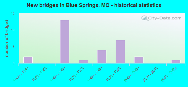
- New bridges - historical statistics
- 21940-1949
- 131960-1969
- 11970-1979
- 41980-1989
- 71990-1999
- 22000-2009
- 12020-2022
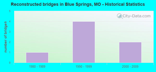
- Reconstructed bridges - Historical Statistics
- 11980-1989
- 41990-1999
- 22000-2009
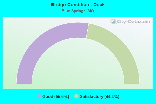
- Bridge Condition - Deck
- 55.6%Good
- 44.4%Satisfactory
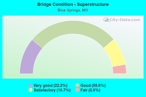
- Bridge Condition - Superstructure
- 22.2%Very good
- 55.6%Good
- 16.7%Satisfactory
- 5.6%Fair
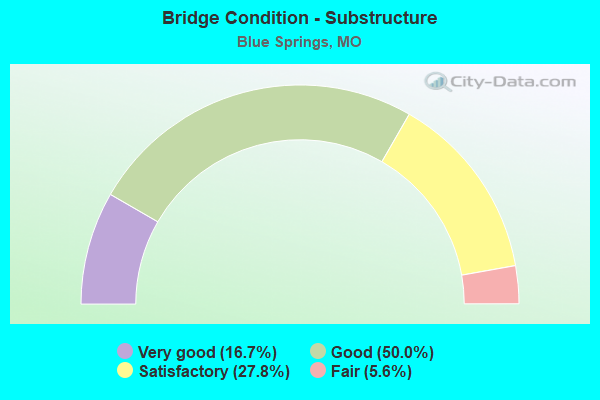
- Bridge Condition - Substructure
- 16.7%Very good
- 50.0%Good
- 27.8%Satisfactory
- 5.6%Fair
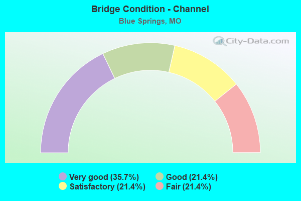
- Bridge Condition - Channel
- 35.7%Very good
- 21.4%Good
- 21.4%Satisfactory
- 21.4%Fair
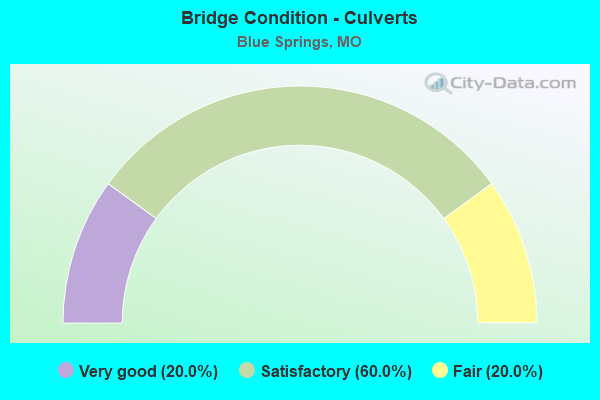
- Bridge Condition - Culverts
- 20.0%Very good
- 60.0%Satisfactory
- 20.0%Fair
Find on map >> Show street view
Structure Number: 1359, Location: S 27 T 26 N R 24 W (Lat: 36.929178, Lng: -93.556028), Route carried "on" structure: State highway A, Year Built: 1966, Year Reconstructed: 2006, Status: Open, Structure Length: 4.91m (16.11ft), Average Daily Traffic: 947 (year 2021), Truck Traffic: 4%, Average Future Daily Traffic: 1,894 (year 2041), Design Load: H 15, Features Intersected: MCCORD BR
Minimum Vertical Clearance: 30+ m (98+ ft), Kilometerpoint: 1.698, Lanes on structure: 2, Owner: State Highway Agency, Approaching Roadway Width: 6.6m (21.7ft), Skew: 1 degrees, Material/Design: Steel continuous, Design/Construction: Stringer/Multi-beam, Number Of Spans In Main Unit: 3, Length of Maximum Span: 18.9m (62.0ft), Curb-To-Curb Width: 8.5m (27.9ft), Out-to-Out Width: 9.4m (30.8ft)
Condition: Deck: Satisfactory, Superstructure: Very good, Substructure: Good, Channel: Good, Operating Rating: 34.2 metric tons, Method Used To Determine Operating Rating: Allowable Stress (AS), Inventory Rating: 21.6 metric tons, Method Used To Determine Inventory Rating: Allowable Stress (AS), Structural Evaluation: Somewhat better than minimum adequacy, Deck Geometry: Somewhat better than minimum adequacy, Waterway Adequacy: Equal to present desirable criteria, Approach Roadway Alignment: Equal to present minimum criteria, Designated Inspection Frequency: Every 24 months, Inspection Date: June 2020, Deck Structure Type: Concrete Cast-file-Place, Wearing Surface/Protective System: Wearing Surface: Epoxy Overlay
Find on map >> Show street view
Structure Number: 1359, Location: S 36 T 49 N R 31 W (Lat: 39.021250, Lng: -94.281364), Route carried "on" structure: City street , Year Built: 1987, Status: Open, Structure Length: 5.33m (17.49ft), Average Daily Traffic: 4,000 (year 2021), Truck Traffic: 10%, Average Future Daily Traffic: 5,200 (year 2041), Features Intersected: KCS RR, Facility Carried by Structure: 15TH ST
Minimum Vertical Clearance: 30+ m (98+ ft), Kilometerpoint: 0.161, Lanes on structure: 2, Owner: City or Municipal Highway Agency, Approaching Roadway Width: 9.8m (32.2ft), Skew: 4 degrees, Material/Design: Steel continuous, Design/Construction: Stringer/Multi-beam, Number Of Spans In Main Unit: 3, Length of Maximum Span: 20.7m (67.9ft), Curb-To-Curb Width: 9.8m (32.2ft), Out-to-Out Width: 13.4m (44.0ft)
Condition: Deck: Good, Superstructure: Satisfactory, Substructure: Fair, Operating Rating: 41.4 metric tons, Method Used To Determine Operating Rating: Allowable Stress (AS), Inventory Rating: 22.5 metric tons, Method Used To Determine Inventory Rating: Allowable Stress (AS), Structural Evaluation: Somewhat better than minimum adequacy, Deck Geometry: Meets minimum limits, Underclear: Superior to present desirable criteria, Approach Roadway Alignment: Equal to present minimum criteria, Designated Inspection Frequency: Every 24 months, Inspection Date: Febuary 2021, Deck Structure Type: Concrete Cast-file-Place, Wearing Surface/Protective System: Wearing Surface: Monolithic Concrete
Find on map >> Show street view
Structure Number: 13591, Location: S 36 T 49 N R 31 W (Lat: 39.016744, Lng: -94.279489), Route carried "on" structure: City street , Year Built: 1987, Status: Open, Structure Length: 4.69m (15.39ft), Average Daily Traffic: 2,000 (year 2021), Truck Traffic: 15%, Average Future Daily Traffic: 2,600 (year 2041), Features Intersected: KCS RR, Facility Carried by Structure: WALNUT ST
Minimum Vertical Clearance: 30+ m (98+ ft), Kilometerpoint: 0.000, Lanes on structure: 2, Owner: City or Municipal Highway Agency, Approaching Roadway Width: 10.1m (33.1ft), Material/Design: Steel continuous, Design/Construction: Stringer/Multi-beam, Number Of Spans In Main Unit: 3, Length of Maximum Span: 18.3m (60.0ft), Curb-To-Curb Width: 9.8m (32.2ft), Out-to-Out Width: 12.2m (40.0ft)
Condition: Deck: Good, Superstructure: Good, Substructure: Good, Operating Rating: 35.1 metric tons, Method Used To Determine Operating Rating: Allowable Stress (AS), Inventory Rating: 17.1 metric tons, Method Used To Determine Inventory Rating: Allowable Stress (AS), Structural Evaluation: Meets minimum limits, Deck Geometry: Somewhat better than minimum adequacy, Underclear: Better than present minimum criteria, Approach Roadway Alignment: Equal to present desirable criteria, Designated Inspection Frequency: Every 24 months, Inspection Date: Febuary 2021, Deck Structure Type: Concrete Cast-file-Place, Wearing Surface/Protective System: Wearing Surface: Monolithic Concrete
Find on map >> Show street view
Structure Number: 19095, Location: S 2 T 48 N R 31 W (Lat: 39.000764, Lng: -94.311744), Route carried "on" structure: County highway 210, Year Built: 1986, Status: Posted for load, Structure Length: 6.49m (21.29ft), Average Daily Traffic: 6,305 (year 2021), Truck Traffic: 15%, Average Future Daily Traffic: 9,458 (year 2041), Design Load: HS 20, Features Intersected: LK BLUE SPR, Facility Carried by Structure: WOODS CHAPEL SB
Minimum Vertical Clearance: 30+ m (98+ ft), Kilometerpoint: 0.966, Lanes on structure: 2, Owner: County Highway Agency, Approaching Roadway Width: 10.7m (35.1ft), Material/Design: Prestressed concrete, Design/Construction: Stringer/Multi-beam, Number Of Spans In Main Unit: 3, Length of Maximum Span: 25.9m (85.0ft), Curb-To-Curb Width: 11.6m (38.1ft), Out-to-Out Width: 12.2m (40.0ft)
Condition: Deck: Good, Superstructure: Very good, Substructure: Very good, Channel: Very good, Operating Rating: 49.5 metric tons, Method Used To Determine Operating Rating: Allowable Stress (AS), Inventory Rating: 27.9 metric tons, Method Used To Determine Inventory Rating: Allowable Stress (AS), Structural Evaluation: Better than present minimum criteria, Deck Geometry: Better than present minimum criteria, Waterway Adequacy: Superior to present desirable criteria, Approach Roadway Alignment: Equal to present desirable criteria, Designated Inspection Frequency: Every 24 months, Inspection Date: Febuary 2021, Deck Structure Type: Concrete Cast-file-Place, Wearing Surface/Protective System: Wearing Surface: Monolithic Concrete
Find on map >> Show street view
Structure Number: 19096, Location: S 2 T 48 N R 31 W (Lat: 39.000797, Lng: -94.311931), Route carried "on" structure: County highway 210, Year Built: 1986, Status: Posted for load, Structure Length: 6.49m (21.29ft), Average Daily Traffic: 5,637 (year 2021), Truck Traffic: 15%, Average Future Daily Traffic: 8,456 (year 2041), Design Load: HS 20, Features Intersected: LK BLUE SPR, Facility Carried by Structure: WOODS CHAPEL NB
Minimum Vertical Clearance: 30+ m (98+ ft), Kilometerpoint: 0.966, Lanes on structure: 2, Owner: County Highway Agency, Approaching Roadway Width: 10.7m (35.1ft), Material/Design: Prestressed concrete, Design/Construction: Stringer/Multi-beam, Number Of Spans In Main Unit: 3, Length of Maximum Span: 25.9m (85.0ft), Curb-To-Curb Width: 11.6m (38.1ft), Out-to-Out Width: 12.2m (40.0ft)
Condition: Deck: Good, Superstructure: Good, Substructure: Very good, Channel: Very good, Operating Rating: 49.5 metric tons, Method Used To Determine Operating Rating: Allowable Stress (AS), Inventory Rating: 27.9 metric tons, Method Used To Determine Inventory Rating: Allowable Stress (AS), Structural Evaluation: Better than present minimum criteria, Deck Geometry: Better than present minimum criteria, Waterway Adequacy: Equal to present desirable criteria, Approach Roadway Alignment: Equal to present desirable criteria, Designated Inspection Frequency: Every 24 months, Inspection Date: Febuary 2021, Deck Structure Type: Concrete Cast-file-Place, Wearing Surface/Protective System: Wearing Surface: Monolithic Concrete
Find on map >> Show street view
Structure Number: 19956, Location: S 34 T 48 N R 31 W (Lat: 38.949919, Lng: -94.230381), Route carried "on" structure: County highway 241, Year Built: 1979, Status: Open, Structure Length: 4.21m (13.81ft), Average Daily Traffic: 224 (year 2021), Truck Traffic: 5%, Average Future Daily Traffic: 336 (year 2041), Design Load: H 20, Features Intersected: PERDUE CR, Facility Carried by Structure: LITCHFORD RD
Minimum Vertical Clearance: 30+ m (98+ ft), Kilometerpoint: 5.150, Lanes on structure: 2, Owner: County Highway Agency, Approaching Roadway Width: 10.4m (34.1ft), Material/Design: Prestressed concrete, Design/Construction: Tee Beam, Number Of Spans In Main Unit: 3, Length of Maximum Span: 13.7m (44.9ft), Curb-To-Curb Width: 8.5m (27.9ft), Out-to-Out Width: 9.1m (29.9ft)
Condition: Deck: Satisfactory, Superstructure: Satisfactory, Substructure: Satisfactory, Channel: Fair, Operating Rating: 44.1 metric tons, Method Used To Determine Operating Rating: Allowable Stress (AS), Inventory Rating: 29.7 metric tons, Method Used To Determine Inventory Rating: Allowable Stress (AS), Structural Evaluation: Equal to present minimum criteria, Deck Geometry: Equal to present minimum criteria, Waterway Adequacy: Better than present minimum criteria, Approach Roadway Alignment: Equal to present desirable criteria, Designated Inspection Frequency: Every 24 months, Inspection Date: Febuary 2021, Deck Structure Type: Concrete Cast-file-Place, Wearing Surface/Protective System: Wearing Surface: Monolithic Concrete
Find on map >> Show street view
Structure Number: 20175, Location: S 22 T 48 N R 30 W (Lat: 38.954100, Lng: -94.210328), Route carried "on" structure: County highway 249, Year Built: 1991, Status: Open, Structure Length: 4.97m (16.31ft), Average Daily Traffic: 3,911 (year 2021), Truck Traffic: 10%, Average Future Daily Traffic: 5,867 (year 2041), Design Load: HS 20, Features Intersected: FK OF SNI-A-BAR CR, Facility Carried by Structure: BUCKNER-TARSNEY RD
Minimum Vertical Clearance: 30+ m (98+ ft), Kilometerpoint: 6.437, Lanes on structure: 2, Owner: County Highway Agency, Approaching Roadway Width: 11.6m (38.1ft), Material/Design: Prestressed concrete, Design/Construction: Stringer/Multi-beam, Number Of Spans In Main Unit: 3, Length of Maximum Span: 16.8m (55.1ft), Curb-To-Curb Width: 12.2m (40.0ft), Out-to-Out Width: 12.8m (42.0ft)
Condition: Deck: Good, Superstructure: Good, Substructure: Satisfactory, Channel: Fair, Operating Rating: 49.5 metric tons, Method Used To Determine Operating Rating: Allowable Stress (AS), Inventory Rating: 32.4 metric tons, Method Used To Determine Inventory Rating: Allowable Stress (AS), Structural Evaluation: Equal to present minimum criteria, Deck Geometry: Equal to present minimum criteria, Waterway Adequacy: Superior to present desirable criteria, Approach Roadway Alignment: Equal to present desirable criteria, Designated Inspection Frequency: Every 24 months, Inspection Date: Febuary 2021, Deck Structure Type: Concrete Cast-file-Place, Wearing Surface/Protective System: Wearing Surface: Monolithic Concrete
Find on map >> Show street view
Structure Number: 28317, Location: S 4 T 47 N R 31 W (Lat: 38.999025, Lng: -94.249897), Route carried "on" structure: City street , Year Built: 1998, Status: Open, Structure Length: 0.69m (2.26ft), Average Daily Traffic: 410 (year 2021), Truck Traffic: 5%, Average Future Daily Traffic: 533 (year 2041), Design Load: HS 20, Features Intersected: E FK LIT BLUE RVR, Facility Carried by Structure: TAYOR RD
Minimum Vertical Clearance: 30+ m (98+ ft), Kilometerpoint: 0.966, Lanes on structure: 2, Owner: County Highway Agency, Approaching Roadway Width: 15.2m (49.9ft), Material/Design: Concrete, Design/Construction: Slab, Number Of Spans In Main Unit: 1, Length of Maximum Span: 6.1m (20.0ft), Curb-To-Curb Width: 8.7m (28.5ft), Out-to-Out Width: 9.8m (32.2ft)
Condition: Deck: Good, Superstructure: Good, Substructure: Good, Channel: Fair, Operating Rating: 46.8 metric tons, Method Used To Determine Operating Rating: Load Factor (LF), Inventory Rating: 27.9 metric tons, Method Used To Determine Inventory Rating: Load Factor (LF), Structural Evaluation: Better than present minimum criteria, Deck Geometry: Somewhat better than minimum adequacy, Waterway Adequacy: Better than present minimum criteria, Approach Roadway Alignment: Equal to present desirable criteria, Designated Inspection Frequency: Every 24 months, Inspection Date: Febuary 2021
Find on map >> Show street view
Structure Number: 2969, Location: S 11 T 48 N R 31 W (Lat: 38.995586, Lng: -94.311867), Route carried "on" structure: County highway 232, Year Built: 2000, Status: Open, Structure Length: 9.63m (31.59ft), Average Daily Traffic: 5,738 (year 2021), Truck Traffic: 10%, Average Future Daily Traffic: 7,459 (year 2041), Features Intersected: DAM SPLWY, Facility Carried by Structure: LIGGETT RD
Minimum Vertical Clearance: 30+ m (98+ ft), Kilometerpoint: 0.483, Lanes on structure: 2, Owner: County Highway Agency, Approaching Roadway Width: 14.6m (47.9ft), Skew: 3 degrees, Material/Design: Prestressed concrete continuous, Design/Construction: Stringer/Multi-beam, Number Of Spans In Main Unit: 4, Length of Maximum Span: 23.8m (78.1ft), Curb-To-Curb Width: 11.2m (36.7ft), Out-to-Out Width: 14.6m (47.9ft)
Condition: Deck: Satisfactory, Superstructure: Good, Substructure: Good, Channel: Good, Inventory Rating: 60.3 metric tons, Method Used To Determine Inventory Rating: Load Factor (LF), Structural Evaluation: Better than present minimum criteria, Deck Geometry: Meets minimum limits, Waterway Adequacy: Superior to present desirable criteria, Approach Roadway Alignment: Equal to present desirable criteria, Designated Inspection Frequency: Every 24 months, Inspection Date: Febuary 2021, Deck Structure Type: Concrete Cast-file-Place, Wearing Surface/Protective System: Wearing Surface: Monolithic Concrete
Find on map >> Show street view
Structure Number: 31001, Location: S 32 T 49 N R 30 W (Lat: 39.011081, Lng: -94.253861), Route carried "on" structure: City street , Year Built: 2004, Status: Open, Structure Length: 1.37m (4.49ft), Average Daily Traffic: 100,000 (year 2021), Truck Traffic: 10%, Average Future Daily Traffic: 130,000 (year 2041), Features Intersected: CREEK, Facility Carried by Structure: ADAMS DIARY ST
Minimum Vertical Clearance: 30+ m (98+ ft), Kilometerpoint: 0.000, Lanes on structure: 4, Owner: City or Municipal Highway Agency, Approaching Roadway Width: 18.3m (60.0ft), Skew: 4 degrees, Material/Design: Concrete continuous, Design/Construction: Culvert, Number Of Spans In Main Unit: 3, Length of Maximum Span: 4.3m (14.1ft)
Condition: Channel: Satisfactory, Culverts: Satisfactory, Operating Rating: 54.0 metric tons, Method Used To Determine Operating Rating: Load Factor (LF), Inventory Rating: 32.4 metric tons, Method Used To Determine Inventory Rating: Load Factor (LF), Structural Evaluation: Equal to present minimum criteria, Waterway Adequacy: Equal to present minimum criteria, Approach Roadway Alignment: Equal to present desirable criteria, Designated Inspection Frequency: Every 24 months, Inspection Date: Febuary 2021, Deck Structure Type: Concrete Cast-file-Place
Find on map >> Show street view
Structure Number: 36412, Location: S 22 T 48 N R 30 W (Lat: 38.950872, Lng: -94.209431), Route carried "on" structure: County highway 421, Year Built: 2020, Status: Posted for load, Structure Length: 1.14m (3.74ft), Average Daily Traffic: 518 (year 2021), Truck Traffic: 2%, Average Future Daily Traffic: 777 (year 2041), Design Load: HS 20, Features Intersected: SPLWY FOR TARSNEY, Facility Carried by Structure: BEACH DR
Minimum Vertical Clearance: 30+ m (98+ ft), Kilometerpoint: 0.161, Lanes on structure: 2, Owner: County Highway Agency, Approaching Roadway Width: 4.6m (15.1ft), Material/Design: Concrete continuous, Design/Construction: Culvert, Number Of Spans In Main Unit: 3, Length of Maximum Span: 3.7m (12.1ft), Curb-To-Curb Width: 9.0m (29.5ft), Out-to-Out Width: 11.0m (36.1ft)
Condition: Channel: Very good, Culverts: Very good, Inventory Rating: 62.1 metric tons, Method Used To Determine Inventory Rating: Load Factor (LF), Structural Evaluation: Equal to present desirable criteria, Deck Geometry: Somewhat better than minimum adequacy, Waterway Adequacy: Superior to present desirable criteria, Approach Roadway Alignment: Equal to present desirable criteria, Designated Inspection Frequency: Every 24 months, Inspection Date: October 2021, Deck Structure Type: Concrete Cast-file-Place, Wearing Surface/Protective System: Wearing Surface: Bituminous
Find on map >> Show street view
Structure Number: 4088, Location: S 29 T 49 N R 30 W (Lat: 39.027436, Lng: -94.249117), Route carried "on" structure: Interstate 70, Year Built: 1992, Status: Open, Structure Length: 5.82m (19.09ft), Average Daily Traffic: 61,833 (year 2021), Truck Traffic: 24%, Average Future Daily Traffic: 83,475 (year 2041), Design Load: HS 20+Mod, Features Intersected: CST ADAMS DAIRY PKWY
Minimum Vertical Clearance: 30+ m (98+ ft), Kilometerpoint: 34.768, Lanes on structure: 4, Lanes under structure: 7, Base Highway Network: Yes, Owner: State Highway Agency, Approaching Roadway Width: 33.5m (109.9ft), Skew: 11 degrees, Material/Design: Steel continuous, Design/Construction: Stringer/Multi-beam, Number Of Spans In Main Unit: 3, Length of Maximum Span: 32.9m (107.9ft), Curb or Sidewalk Widths: Left: 0.2m (0.7ft), Right: 0.2m (0.7ft), Curb-To-Curb Width: 32.6m (107.0ft), Out-to-Out Width: 33.4m (109.6ft)
Condition: Deck: Satisfactory, Superstructure: Good, Substructure: Good, Operating Rating: 60.3 metric tons, Method Used To Determine Operating Rating: Load Factor (LF), Inventory Rating: 36.0 metric tons, Method Used To Determine Inventory Rating: Load Factor (LF), Structural Evaluation: Better than present minimum criteria, Deck Geometry: Superior to present desirable criteria, Underclear: Somewhat better than minimum adequacy, Approach Roadway Alignment: Equal to present desirable criteria, Designated Inspection Frequency: Every 24 months, Inspection Date: October 2021, Deck Structure Type: Concrete Cast-file-Place, Wearing Surface/Protective System: Wearing Surface: Monolithic Concrete, Deck Protection: Epoxy Coated Reinforcing
Find on map >> Show street view
Structure Number: 41, Location: S 28 T 49 N R 31 W (Lat: 39.040017, Lng: -94.349575), Route carried "on" structure: Interstate 70, Year Built: 1964, Year Reconstructed: 2004, Status: Posted for load, Structure Length: 6.64m (21.78ft), Average Daily Traffic: 48,773 (year 2021), Truck Traffic: 24%, Average Future Daily Traffic: 65,844 (year 2041), Design Load: HS 20+Mod, Features Intersected: LIT BLUE RVR
Minimum Vertical Clearance: 30+ m (98+ ft), Kilometerpoint: 25.952, Lanes on structure: 4, Base Highway Network: Yes, Owner: State Highway Agency, Approaching Roadway Width: 16.5m (54.1ft), Skew: 2 degrees, Material/Design: Steel continuous, Design/Construction: Stringer/Multi-beam, Number Of Spans In Main Unit: 3, Length of Maximum Span: 24.4m (80.1ft), Curb or Sidewalk Widths: Left: 0.2m (0.7ft), Right: 0.2m (0.7ft), Curb-To-Curb Width: 15.8m (51.8ft), Out-to-Out Width: 16.6m (54.5ft)
Condition: Deck: Good, Superstructure: Very good, Substructure: Good, Channel: Very good, Operating Rating: 52.2 metric tons, Method Used To Determine Operating Rating: Load Factor (LF), Inventory Rating: 31.5 metric tons, Method Used To Determine Inventory Rating: Load Factor (LF), Structural Evaluation: Better than present minimum criteria, Deck Geometry: Meets minimum limits, Waterway Adequacy: Equal to present desirable criteria, Approach Roadway Alignment: Equal to present desirable criteria, Designated Inspection Frequency: Every 24 months, Inspection Date: October 2021, Deck Structure Type: Concrete Cast-file-Place, Wearing Surface/Protective System: Wearing Surface: Monolithic Concrete
Find on map >> Show street view
Structure Number: 43, Location: S 28 T 49 N R 30 W (Lat: 39.026256, Lng: -94.239192), Route carried "on" structure: Interstate 70, Year Built: 1963, Status: Open, Structure Length: 0.88m (2.89ft), Average Daily Traffic: 63,066 (year 2021), Truck Traffic: 24%, Average Future Daily Traffic: 85,139 (year 2041), Design Load: HS 20, Features Intersected: SNI CR
Minimum Vertical Clearance: 30+ m (98+ ft), Kilometerpoint: 35.670, Lanes on structure: 8, Base Highway Network: Yes, Owner: State Highway Agency, Approaching Roadway Width: 32.9m (107.9ft), Skew: 23 degrees, Material/Design: Concrete continuous, Design/Construction: Culvert, Number Of Spans In Main Unit: 2, Length of Maximum Span: 3.7m (12.1ft)
Condition: Channel: Very good, Culverts: Fair, Structural Evaluation: Somewhat better than minimum adequacy, Waterway Adequacy: Equal to present desirable criteria, Approach Roadway Alignment: Equal to present desirable criteria, Designated Inspection Frequency: Every 24 months, Inspection Date: November 2021
Find on map >> Show street view
Structure Number: 4398, Location: S 28 T 49 N R 31 W (Lat: 39.038939, Lng: -94.341114), Route carried "on" structure: City street , Year Built: 1997, Status: Open, Structure Length: 9.42m (30.91ft), Average Daily Traffic: 22,116 (year 2021), Truck Traffic: 5%, Average Future Daily Traffic: 29,857 (year 2041), Design Load: HS 20+Mod, Features Intersected: IS 70, Facility Carried by Structure: LITTLE BLUE PKWY S
Minimum Vertical Clearance: 30+ m (98+ ft), Kilometerpoint: 12.487, Lanes on structure: 6, Lanes under structure: 6, Base Highway Network: Yes, Owner: State Highway Agency, Approaching Roadway Width: 26.5m (86.9ft), Skew: 20 degrees, Material/Design: Steel continuous, Design/Construction: Stringer/Multi-beam, Number Of Spans In Main Unit: 2, Length of Maximum Span: 42.3m (138.8ft), Curb or Sidewalk Widths: Left: 1.7m (5.6ft), Right: 1.7m (5.6ft), Curb-To-Curb Width: 29.4m (96.5ft), Out-to-Out Width: 34.4m (112.9ft)
Condition: Deck: Good, Superstructure: Very good, Substructure: Good, Operating Rating: 63.0 metric tons, Method Used To Determine Operating Rating: Load Factor (LF), Inventory Rating: 37.8 metric tons, Method Used To Determine Inventory Rating: Load Factor (LF), Structural Evaluation: Better than present minimum criteria, Deck Geometry: Better than present minimum criteria, Underclear: High priority of corrective action, Approach Roadway Alignment: Equal to present desirable criteria, Designated Inspection Frequency: Every 24 months, Inspection Date: October 2021, Deck Structure Type: Concrete Cast-file-Place, Wearing Surface/Protective System: Wearing Surface: Monolithic Concrete, Deck Protection: Epoxy Coated Reinforcing
Find on map >> Show street view
Structure Number: 6091, Location: S 32 T 49 N R 30 W (Lat: 39.012928, Lng: -94.258169), Route carried "on" structure: US 40, Year Built: 1948, Status: Open, Structure Length: 0.81m (2.66ft), Average Daily Traffic: 10,192 (year 2021), Truck Traffic: 8%, Average Future Daily Traffic: 13,759 (year 2041), Design Load: H 20, Features Intersected: BR BLUE CR
Minimum Vertical Clearance: 30+ m (98+ ft), Kilometerpoint: 35.845, Lanes on structure: 2, Owner: State Highway Agency, Approaching Roadway Width: 12.2m (40.0ft), Skew: 3 degrees, Material/Design: Concrete continuous, Design/Construction: Culvert, Number Of Spans In Main Unit: 2, Length of Maximum Span: 3.4m (11.2ft)
Condition: Channel: Good, Culverts: Satisfactory, Operating Rating: 72.0 metric tons, Method Used To Determine Operating Rating: Field evaluation and documented engineering judgment, Inventory Rating: 43.2 metric tons, Method Used To Determine Inventory Rating: Field evaluation and documented engineering judgment, Structural Evaluation: Equal to present minimum criteria, Waterway Adequacy: Equal to present minimum criteria, Approach Roadway Alignment: Equal to present desirable criteria, Designated Inspection Frequency: Every 24 months, Inspection Date: November 2021
Find on map >> Show street view
Structure Number: 6092, Location: S 33 T 49 N R 30 W (Lat: 39.013936, Lng: -94.235550), Route carried "on" structure: US 40, Year Built: 1948, Status: Open, Structure Length: 0.67m (2.20ft), Average Daily Traffic: 6,666 (year 2021), Truck Traffic: 4%, Average Future Daily Traffic: 8,999 (year 2041), Design Load: H 20, Features Intersected: BLUE BR TRIB
Minimum Vertical Clearance: 30+ m (98+ ft), Kilometerpoint: 37.808, Lanes on structure: 2, Owner: State Highway Agency, Approaching Roadway Width: 13.4m (44.0ft), Material/Design: Concrete, Design/Construction: Culvert, Number Of Spans In Main Unit: 1, Length of Maximum Span: 6.7m (22.0ft)
Condition: Channel: Satisfactory, Culverts: Satisfactory, Operating Rating: 95.4 metric tons, Method Used To Determine Operating Rating: Load Factor (LF), Inventory Rating: 57.6 metric tons, Method Used To Determine Inventory Rating: Load Factor (LF), Structural Evaluation: Equal to present minimum criteria, Waterway Adequacy: Equal to present desirable criteria, Approach Roadway Alignment: Equal to present desirable criteria, Designated Inspection Frequency: Every 24 months, Inspection Date: November 2021
Find on map >> Show street view
Structure Number: 6645, Location: S 28 T 49 N R 31 W (Lat: 39.037781, Lng: -94.333281), Route carried "on" structure: Interstate 70, Year Built: 1963, Year Reconstructed: 2004, Status: Open, Structure Length: 5.00m (16.40ft), Average Daily Traffic: 48,851 (year 2021), Truck Traffic: 23%, Average Future Daily Traffic: 65,949 (year 2041), Design Load: HS 20+Mod, Features Intersected: KCS RR
Minimum Vertical Clearance: 30+ m (98+ ft), Kilometerpoint: 27.402, Lanes on structure: 3, Base Highway Network: Yes, Owner: State Highway Agency, Approaching Roadway Width: 16.5m (54.1ft), Skew: 2 degrees, Material/Design: Steel continuous, Design/Construction: Stringer/Multi-beam, Number Of Spans In Main Unit: 3, Length of Maximum Span: 18.3m (60.0ft), Curb or Sidewalk Widths: Left: 0.2m (0.7ft), Right: 0.2m (0.7ft), Curb-To-Curb Width: 18.3m (60.0ft), Out-to-Out Width: 19.1m (62.7ft)
Condition: Deck: Good, Superstructure: Good, Substructure: Good, Operating Rating: 53.1 metric tons, Method Used To Determine Operating Rating: Load Factor (LF), Inventory Rating: 32.4 metric tons, Method Used To Determine Inventory Rating: Load Factor (LF), Structural Evaluation: Better than present minimum criteria, Deck Geometry: Better than present minimum criteria, Underclear: Superior to present desirable criteria, Approach Roadway Alignment: Equal to present desirable criteria, Designated Inspection Frequency: Every 24 months, Inspection Date: October 2021, Deck Structure Type: Concrete Cast-file-Place, Wearing Surface/Protective System: Wearing Surface: Other
Find on map >> Show street view
Structure Number: 6646, Location: S 28 T 49 N R 31 W (Lat: 39.037964, Lng: -94.333303), Route carried "on" structure: Interstate 70, Year Built: 1963, Year Reconstructed: 2004, Status: Open, Structure Length: 5.00m (16.40ft), Average Daily Traffic: 53,434 (year 2021), Truck Traffic: 24%, Average Future Daily Traffic: 72,136 (year 2041), Design Load: HS 20+Mod, Features Intersected: KCS RR
Minimum Vertical Clearance: 30+ m (98+ ft), Kilometerpoint: 374.865, Lanes on structure: 3, Base Highway Network: Yes, Owner: State Highway Agency, Approaching Roadway Width: 16.5m (54.1ft), Skew: 2 degrees, Material/Design: Steel continuous, Design/Construction: Stringer/Multi-beam, Number Of Spans In Main Unit: 3, Length of Maximum Span: 18.3m (60.0ft), Curb or Sidewalk Widths: Left: 0.2m (0.7ft), Right: 0.2m (0.7ft), Curb-To-Curb Width: 15.8m (51.8ft), Out-to-Out Width: 16.6m (54.5ft)
Condition: Deck: Satisfactory, Superstructure: Good, Substructure: Good, Operating Rating: 53.1 metric tons, Method Used To Determine Operating Rating: Load Factor (LF), Inventory Rating: 32.4 metric tons, Method Used To Determine Inventory Rating: Load Factor (LF), Structural Evaluation: Better than present minimum criteria, Deck Geometry: Somewhat better than minimum adequacy, Underclear: Superior to present desirable criteria, Approach Roadway Alignment: Equal to present desirable criteria, Designated Inspection Frequency: Every 24 months, Inspection Date: October 2021, Deck Structure Type: Concrete Cast-file-Place, Wearing Surface/Protective System: Wearing Surface: Other
Find on map >> Show street view
Structure Number: 6647, Location: S 26 T 49 N R 31 W (Lat: 39.034131, Lng: -94.305367), Route carried "on" structure: City street , Year Built: 1963, Year Reconstructed: 2012, Status: Posted for load, Structure Length: 6.28m (20.60ft), Average Daily Traffic: 10,296 (year 2021), Truck Traffic: 5%, Average Future Daily Traffic: 13,900 (year 2041), Design Load: HS 20+Mod, Features Intersected: IS 70, Facility Carried by Structure: WOODS CHAPEL RD S
Minimum Vertical Clearance: 30+ m (98+ ft), Kilometerpoint: 0.156, Lanes on structure: 5, Lanes under structure: 6, Owner: State Highway Agency, Approaching Roadway Width: 18.9m (62.0ft), Skew: 1 degrees, Material/Design: Steel continuous, Design/Construction: Stringer/Multi-beam, Number Of Spans In Main Unit: 4, Length of Maximum Span: 17.4m (57.1ft), Curb-To-Curb Width: 22.2m (72.8ft), Out-to-Out Width: 23.0m (75.5ft)
Condition: Deck: Good, Superstructure: Fair, Substructure: Very good, Operating Rating: 43.2 metric tons, Method Used To Determine Operating Rating: Load Factor (LF), Inventory Rating: 26.1 metric tons, Method Used To Determine Inventory Rating: Load Factor (LF), Structural Evaluation: Somewhat better than minimum adequacy, Deck Geometry: Equal to present minimum criteria, Underclear: Meets minimum limits, Approach Roadway Alignment: Equal to present desirable criteria, Designated Inspection Frequency: Every 24 months, Inspection Date: October 2021, Deck Structure Type: Concrete Cast-file-Place, Wearing Surface/Protective System: Wearing Surface: Epoxy Overlay, Deck Protection: Epoxy Coated Reinforcing
Find on map >> Show street view
Structure Number: 6648, Location: S 30 T 49 N R 30 W (Lat: 39.030306, Lng: -94.271742), Route carried "on" structure: Interstate 70, Year Built: 1963, Year Reconstructed: 1994, Status: Posted for load, Structure Length: 4.88m (16.01ft), Average Daily Traffic: 30,821 (year 2021), Truck Traffic: 24%, Average Future Daily Traffic: 41,608 (year 2041), Design Load: HS 20, Features Intersected: MO 7
Minimum Vertical Clearance: 30+ m (98+ ft), Kilometerpoint: 369.471, Lanes on structure: 2, Lanes under structure: 7, Base Highway Network: Yes, Owner: State Highway Agency, Approaching Roadway Width: 16.5m (54.1ft), Skew: 10 degrees, Material/Design: Steel continuous, Design/Construction: Stringer/Multi-beam, Number Of Spans In Main Unit: 3, Length of Maximum Span: 20.7m (67.9ft), Curb or Sidewalk Widths: Left: 0.2m (0.7ft), Right: 0.2m (0.7ft), Curb-To-Curb Width: 16.0m (52.5ft), Out-to-Out Width: 16.9m (55.4ft)
Condition: Deck: Satisfactory, Superstructure: Good, Substructure: Satisfactory, Operating Rating: 54.9 metric tons, Method Used To Determine Operating Rating: Load Factor (LF), Inventory Rating: 32.4 metric tons, Method Used To Determine Inventory Rating: Load Factor (LF), Structural Evaluation: Equal to present minimum criteria, Deck Geometry: Superior to present desirable criteria, Underclear: High priority of corrective action, Approach Roadway Alignment: Equal to present desirable criteria, Designated Inspection Frequency: Every 24 months, Inspection Date: October 2021, Deck Structure Type: Concrete Cast-file-Place, Wearing Surface/Protective System: Wearing Surface: Monolithic Concrete, Deck Protection: Epoxy Coated Reinforcing
Find on map >> Show street view
Structure Number: 669, Location: S 20 T 29 N R 14 E (Lat: 37.167050, Lng: -89.537522), Route carried "on" structure: Interstate 55, Year Built: 1962, Status: Open, Structure Length: 5.73m (18.80ft), Average Daily Traffic: 10,623 (year 2021), Truck Traffic: 31%, Average Future Daily Traffic: 20,184 (year 2041), Design Load: HS 20+Mod, Features Intersected: RAMSEY CR
Minimum Vertical Clearance: 30+ m (98+ ft), Kilometerpoint: 198.587, Lanes on structure: 2, Base Highway Network: Yes, Owner: State Highway Agency, Approaching Roadway Width: 11.6m (38.1ft), Skew: 11 degrees, Material/Design: Steel continuous, Design/Construction: Stringer/Multi-beam, Number Of Spans In Main Unit: 3, Length of Maximum Span: 21.9m (71.9ft), Curb-To-Curb Width: 9.1m (29.9ft), Out-to-Out Width: 10.2m (33.5ft)
Condition: Deck: Satisfactory, Superstructure: Satisfactory, Substructure: Satisfactory, Channel: Satisfactory, Operating Rating: 43.2 metric tons, Method Used To Determine Operating Rating: Load Factor (LF), Inventory Rating: 26.1 metric tons, Method Used To Determine Inventory Rating: Load Factor (LF), Structural Evaluation: Equal to present minimum criteria, Deck Geometry: High priority of replacement, Waterway Adequacy: Equal to present desirable criteria, Approach Roadway Alignment: Equal to present desirable criteria, Length Of Structure Improvement: 0.68m (2.23ft), Designated Inspection Frequency: Every 24 months, Inspection Date: Febuary 2021, Bridge Improvement Cost: $555,000, Roadway Improvement Cost: $55,000, Total Project Cost: $832,000 ( Estimate for 2022), Deck Structure Type: Concrete Cast-file-Place, Wearing Surface/Protective System: Wearing Surface: Bituminous
Find on map >> Show street view
Structure Number: 669, Location: S 30 T 49 N R 30 W (Lat: 39.030153, Lng: -94.271769), Route carried "on" structure: Interstate 70, Year Built: 1963, Year Reconstructed: 1996, Status: Posted for load, Structure Length: 4.88m (16.01ft), Average Daily Traffic: 41,013 (year 2021), Truck Traffic: 24%, Average Future Daily Traffic: 55,368 (year 2041), Design Load: HS 20, Features Intersected: MO 7
Minimum Vertical Clearance: 30+ m (98+ ft), Kilometerpoint: 32.797, Lanes on structure: 2, Lanes under structure: 7, Base Highway Network: Yes, Owner: State Highway Agency, Approaching Roadway Width: 15.8m (51.8ft), Material/Design: Steel continuous, Design/Construction: Stringer/Multi-beam, Number Of Spans In Main Unit: 3, Length of Maximum Span: 20.7m (67.9ft), Curb or Sidewalk Widths: Left: 0.2m (0.7ft), Right: 0.2m (0.7ft), Curb-To-Curb Width: 16.0m (52.5ft), Out-to-Out Width: 16.9m (55.4ft)
Condition: Deck: Satisfactory, Superstructure: Good, Substructure: Satisfactory, Operating Rating: 54.0 metric tons, Method Used To Determine Operating Rating: Load Factor (LF), Inventory Rating: 32.4 metric tons, Method Used To Determine Inventory Rating: Load Factor (LF), Structural Evaluation: Equal to present minimum criteria, Deck Geometry: Superior to present desirable criteria, Underclear: High priority of corrective action, Approach Roadway Alignment: Equal to present desirable criteria, Designated Inspection Frequency: Every 24 months, Inspection Date: October 2021, Deck Structure Type: Concrete Cast-file-Place, Wearing Surface/Protective System: Wearing Surface: Monolithic Concrete, Deck Protection: Epoxy Coated Reinforcing
Find on map >> Show street view
Structure Number: 4088, Location: S 29 T 49 N R 30 W (Lat: 39.027436, Lng: -94.249117), Route carried "under" structure: City street , Year Built: 1992, Structure Length: 0. m, Average Daily Traffic: 15,679 (year 2021), Truck Traffic: 5%, Features Intersected: CST ADAMS DAIRY PKWY, Facility Carried by Structure: IS 70 E
Minimum Vertical Clearance: 5.05m (16.57ft), Kilometerpoint: 1.986, Lanes on structure: 4, Lanes under structure: 7, Material/Design: Steel continuous, Design/Construction: Stringer/Multi-beam, Length of Maximum Span: 32.9m (107.9ft)
Find on map >> Show street view
Structure Number: 4398, Location: S 28 T 49 N R 31 W (Lat: 39.038939, Lng: -94.341114), Route carried "under" structure: Interstate 70, Year Built: 1997, Structure Length: 0. m, Average Daily Traffic: 53,434 (year 2021), Truck Traffic: 24%, Features Intersected: IS 70, Facility Carried by Structure: LITTLE BLUE PKWY S
Minimum Vertical Clearance: 5.28m (17.32ft), Kilometerpoint: 375.560, Lanes on structure: 6, Lanes under structure: 3, Material/Design: Steel continuous, Design/Construction: Stringer/Multi-beam, Length of Maximum Span: 42.3m (138.8ft)
Find on map >> Show street view
Structure Number: 4398, Location: S 28 T 49 N R 31 W (Lat: 39.038939, Lng: -94.341114), Route carried "under" structure: Interstate 70, Year Built: 1997, Structure Length: 0. m, Average Daily Traffic: 48,773 (year 2021), Truck Traffic: 24%, Features Intersected: IS 70, Facility Carried by Structure: LITTLE BLUE PKWY S
Minimum Vertical Clearance: 5.84m (19.16ft), Kilometerpoint: 26.755, Lanes on structure: 6, Lanes under structure: 3, Material/Design: Steel continuous, Design/Construction: Stringer/Multi-beam, Length of Maximum Span: 42.3m (138.8ft)
Find on map >> Show street view
Structure Number: 6647, Location: S 26 T 49 N R 31 W (Lat: 39.034131, Lng: -94.305367), Route carried "under" structure: Interstate 70, Year Built: 1963, Structure Length: 0. m, Average Daily Traffic: 41,295 (year 2021), Truck Traffic: 24%, Features Intersected: IS 70, Facility Carried by Structure: WOODS CHAPEL RD S
Minimum Vertical Clearance: 5.02m (16.47ft), Kilometerpoint: 372.433, Lanes on structure: 5, Lanes under structure: 3, Material/Design: Steel continuous, Design/Construction: Stringer/Multi-beam, Length of Maximum Span: 17.4m (57.1ft)
Find on map >> Show street view
Structure Number: 6647, Location: S 26 T 49 N R 31 W (Lat: 39.034131, Lng: -94.305367), Route carried "under" structure: Interstate 70, Year Built: 1963, Structure Length: 0. m, Average Daily Traffic: 48,851 (year 2021), Truck Traffic: 23%, Features Intersected: IS 70, Facility Carried by Structure: WOODS CHAPEL RD S
Minimum Vertical Clearance: 5.03m (16.50ft), Kilometerpoint: 29.886, Lanes on structure: 5, Lanes under structure: 3, Material/Design: Steel continuous, Design/Construction: Stringer/Multi-beam, Length of Maximum Span: 17.4m (57.1ft)
Find on map >> Show street view
Structure Number: 6648, Location: S 30 T 49 N R 30 W (Lat: 39.030306, Lng: -94.271742), Route carried "under" structure: State highway 7, Year Built: 1963, Structure Length: 0. m, Average Daily Traffic: 31,542 (year 2021), Truck Traffic: 5%, Features Intersected: MO 7
Minimum Vertical Clearance: 4.62m (15.16ft), Kilometerpoint: 12.521, Lanes on structure: 2, Lanes under structure: 7, Material/Design: Steel continuous, Design/Construction: Stringer/Multi-beam, Length of Maximum Span: 20.7m (67.9ft)
Find on map >> Show street view
Structure Number: 669, Location: S 30 T 49 N R 30 W (Lat: 39.030153, Lng: -94.271769), Route carried "under" structure: State highway 7, Year Built: 1963, Structure Length: 0. m, Average Daily Traffic: 31,022 (year 2021), Truck Traffic: 5%, Features Intersected: MO 7
Minimum Vertical Clearance: 4.60m (15.09ft), Kilometerpoint: 12.538, Lanes on structure: 2, Lanes under structure: 7, Material/Design: Steel continuous, Design/Construction: Stringer/Multi-beam, Length of Maximum Span: 20.7m (67.9ft)