Bridge Statistics for Buffalo, New York (NY)
Condition, Traffic, Stress, Structural Evaluation, Project Costs
- National Bridge Inventory (NBI) Statistics
- 314Number of bridges
- 5,945ft / 1,812mTotal length
- $1,983,481,000Total costs
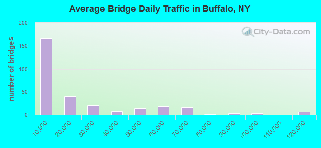
- 6,044,286Total average daily traffic
- 185,043Total average daily truck traffic
- National Bridge Inventory (NBI) Registered Bridges for Buffalo
- No street view available for this location
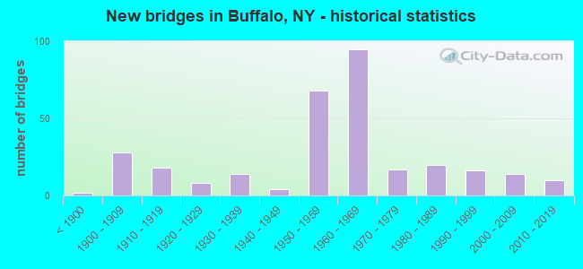
- New bridges - historical statistics
- 2Before 1900
- 281900-1909
- 181910-1919
- 81920-1929
- 141930-1939
- 41940-1949
- 681950-1959
- 951960-1969
- 171970-1979
- 201980-1989
- 161990-1999
- 142000-2009
- 102010-2019
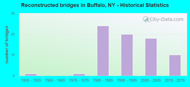
- Reconstructed bridges - Historical Statistics
- 11950-1959
- 01960-1969
- 11970-1979
- 241980-1989
- 201990-1999
- 182000-2009
- 102010-2019

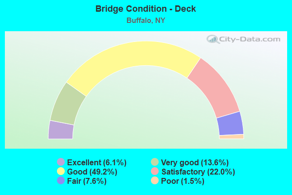
- Bridge Condition - Deck
- 6.1%Excellent
- 13.6%Very good
- 49.2%Good
- 22.0%Satisfactory
- 7.6%Fair
- 1.5%Poor
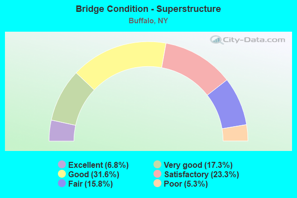
- Bridge Condition - Superstructure
- 6.8%Excellent
- 17.3%Very good
- 31.6%Good
- 23.3%Satisfactory
- 15.8%Fair
- 5.3%Poor
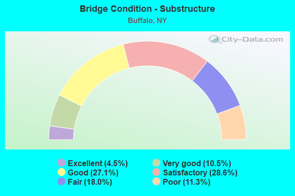
- Bridge Condition - Substructure
- 4.5%Excellent
- 10.5%Very good
- 27.1%Good
- 28.6%Satisfactory
- 18.0%Fair
- 11.3%Poor
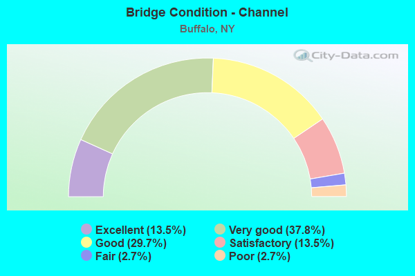
- Bridge Condition - Channel
- 13.5%Excellent
- 37.8%Very good
- 29.7%Good
- 13.5%Satisfactory
- 2.7%Fair
- 2.7%Poor
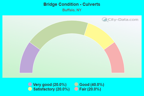
- Bridge Condition - Culverts
- 20.0%Very good
- 40.0%Good
- 20.0%Satisfactory
- 20.0%Fair
Find on map >> Show street view
Structure Number: 100152, Location: 3.1 MI N JCT NY5 & 179 (Lat: 42.833778, Lng: -78.853933), Route carried "on" structure: State highway 5, Year Built: 1991, Year Reconstructed: 2000, Status: Open, Structure Length: 8.53m (27.99ft), Average Daily Traffic: 21,487 (year 2019), Truck Traffic: 5%, Average Future Daily Traffic: 24,899 (year 2040), Design Load: HS 25 or greater, Features Intersected: COMMERCE STREET, UNION S
Minimum Vertical Clearance: 30+ m (98+ ft), Kilometerpoint: 38.922, Lanes on structure: 4, Lanes under structure: 4, Base Highway Network: Yes, Owner: State Highway Agency, Approaching Roadway Width: 25.0m (82.0ft), Skew: 20 degrees, Navigation Control: Yes ( Vertical Clearance: 7.3m (24.0ft), Horizontal Clearance: 15.2m (49.9ft)), Material/Design: Steel continuous, Design/Construction: Stringer/Multi-beam, Number Of Spans In Main Unit: 3, Length of Maximum Span: 27.7m (90.9ft), Curb-To-Curb Width: 24.8m (81.4ft), Out-to-Out Width: 25.8m (84.6ft)
Condition: Deck: Good, Superstructure: Very good, Substructure: Very good, Channel: Very good, Operating Rating: 88.9 metric tons, Method Used To Determine Operating Rating: Load Factor (LF), Inventory Rating: 48.1 metric tons, Method Used To Determine Inventory Rating: Load Factor (LF), Structural Evaluation: Equal to present desirable criteria, Deck Geometry: Superior to present desirable criteria, Underclear: High priority of corrective action, Waterway Adequacy: Equal to present desirable criteria, Approach Roadway Alignment: Equal to present desirable criteria, Length Of Structure Improvement: 8.53m (27.99ft), Designated Inspection Frequency: Every 24 months, Inspection Date: September 2020, Bridge Improvement Cost: $7,939,000, Roadway Improvement Cost: $4,649,000, Total Project Cost: $12,589,000 ( Estimate for 2021), Deck Structure Type: Concrete Cast-file-Place, Wearing Surface/Protective System: Wearing Surface: Integral Concrete, Deck Protection: Epoxy Coated Reinforcing
Find on map >> Show street view
Structure Number: 1001549, Location: 2.1 M SOUTH OF RTE I-90 & (Lat: 42.853028, Lng: -78.864086), Route carried "on" structure: State highway 5, Year Built: 2009, Status: Open, Structure Length: 1.89m (6.20ft), Average Daily Traffic: 28,661 (year 2020), Truck Traffic: 7%, Average Future Daily Traffic: 33,212 (year 2040), Design Load: HS 20+Mod, Features Intersected: OHIO ST
Minimum Vertical Clearance: 30+ m (98+ ft), Kilometerpoint: 41.223, Lanes on structure: 4, Lanes under structure: 3, Base Highway Network: Yes, Owner: State Highway Agency, Approaching Roadway Width: 22.9m (75.1ft), Skew: 20 degrees, Material/Design: Concrete, Design/Construction: Culvert, Number Of Spans In Main Unit: 1, Length of Maximum Span: 18.2m (59.7ft), Curb-To-Curb Width: 22.9m (75.1ft), Out-to-Out Width: 24.6m (80.7ft)
Condition: Culverts: Good, Operating Rating: 80.7 metric tons, Method Used To Determine Operating Rating: Load Factor (LF), Inventory Rating: 48.1 metric tons, Method Used To Determine Inventory Rating: Load Factor (LF), Structural Evaluation: Better than present minimum criteria, Deck Geometry: Superior to present desirable criteria, Underclear: Meets minimum limits, Approach Roadway Alignment: Equal to present desirable criteria, Length Of Structure Improvement: 1.88m (6.17ft), Designated Inspection Frequency: Every 24 months, Inspection Date: September 2021, Bridge Improvement Cost: $2,460,000, Roadway Improvement Cost: $1,441,000, Total Project Cost: $3,901,000 ( Estimate for 2021), Wearing Surface/Protective System: Wearing Surface: Bituminous, Membrane: Other
Find on map >> Show street view
Structure Number: 1001559, Location: 2.4 MI S JCT SH 5 & SH 16 (Lat: 42.855297, Lng: -78.866497), Route carried "on" structure: State highway 5, Year Built: 1965, Year Reconstructed: 1991, Status: Open, Structure Length: 6.55m (21.49ft), Average Daily Traffic: 28,661 (year 2020), Truck Traffic: 7%, Average Future Daily Traffic: 33,212 (year 2040), Design Load: HS 20+Mod, Features Intersected: ABD BUFFALO CREEK RR
Minimum Vertical Clearance: 30+ m (98+ ft), Kilometerpoint: 41.512, Lanes on structure: 4, Base Highway Network: Yes, Owner: State Highway Agency, Approaching Roadway Width: 23.8m (78.1ft), Skew: 24 degrees, Material/Design: Steel, Design/Construction: Stringer/Multi-beam, Number Of Spans In Main Unit: 3, Length of Maximum Span: 21.3m (69.9ft), Curb or Sidewalk Widths: Left: 0.5m (1.6ft), Right: 0.5m (1.6ft), Curb-To-Curb Width: 18.9m (62.0ft), Out-to-Out Width: 20.5m (67.3ft)
Condition: Deck: Satisfactory, Superstructure: Good, Substructure: Fair, Operating Rating: 62.6 metric tons, Method Used To Determine Operating Rating: Load Factor (LF), Inventory Rating: 36.3 metric tons, Method Used To Determine Inventory Rating: Load Factor (LF), Structural Evaluation: Somewhat better than minimum adequacy, Deck Geometry: Meets minimum limits, Approach Roadway Alignment: Somewhat better than minimum adequacy, Length Of Structure Improvement: 6.55m (21.49ft), Designated Inspection Frequency: Every 24 months, Inspection Date: November 2020, Bridge Improvement Cost: $5,007,000, Roadway Improvement Cost: $2,932,000, Total Project Cost: $7,939,000 ( Estimate for 2021), Deck Structure Type: Concrete Cast-file-Place, Wearing Surface/Protective System: Wearing Surface: Integral Concrete
Find on map >> Show street view
Structure Number: 1001579, Location: JCT OF RTS 5 & I-190 (Lat: 42.879917, Lng: -78.878889), Route carried "on" structure: State highway 5, Year Built: 1956, Year Reconstructed: 2019, Status: Open, Structure Length: 176.91m (580.41ft), Average Daily Traffic: 22,644 (year 2020), Truck Traffic: 6%, Average Future Daily Traffic: 26,239 (year 2040), Design Load: HS 20, Features Intersected: 190IX SB, RTE I190, BUFF
Minimum Vertical Clearance: 30+ m (98+ ft), Kilometerpoint: 43.105, Lanes on structure: 4, Lanes under structure: 10, Base Highway Network: Yes, Owner: State Highway Agency, Approaching Roadway Width: 17.4m (57.1ft), Skew: 20 degrees, Navigation Control: Yes ( Vertical Clearance: 30.4m (99.7ft), Horizontal Clearance: 65.5m (214.9ft)), Material/Design: Steel, Design/Construction: Girder and Floorbeam System, Number Of Spans In Main Unit: 49, Length of Maximum Span: 106.1m (348.1ft), Curb-To-Curb Width: 17.3m (56.8ft), Out-to-Out Width: 18.3m (60.0ft)
Condition: Deck: Good, Superstructure: Fair, Substructure: Satisfactory, Channel: Satisfactory, Operating Rating: 81.5 metric tons, Method Used To Determine Operating Rating: Field evaluation and documented engineering judgment, Inventory Rating: 32.7 metric tons, Method Used To Determine Inventory Rating: Field evaluation and documented engineering judgment, Structural Evaluation: Somewhat better than minimum adequacy, Deck Geometry: Meets minimum limits, Underclear: High priority of corrective action, Waterway Adequacy: Meets minimum limits, Approach Roadway Alignment: Equal to present desirable criteria, Length Of Structure Improvement: 176.90m (580.38ft), Designated Inspection Frequency: Every 24 months, Critical Feature Inspection Frequency: Every 24 months, Underwater Inspection Frequency: Every 60 months, Inspection Date: December 2021, Critical Feature Inspection Date: December 2021, Underwater Inspection Date: September 2021, Bridge Improvement Cost: $105,190,000, Roadway Improvement Cost: $61,600,000, Total Project Cost: $166,790,000 ( Estimate for 2021), Deck Structure Type: Concrete Cast-file-Place, Wearing Surface/Protective System: Wearing Surface: Integral Concrete
Find on map >> Show street view
Structure Number: 100157A, Location: JCT OF SH 5 & I190 (Lat: 42.879231, Lng: -78.877878), Route carried "on" structure: Ramp Interstate , Year Built: 1958, Year Reconstructed: 1996, Status: Open, Structure Length: 18.35m (60.20ft), Average Daily Traffic: 3,941 (year 2017), Truck Traffic: 7%, Average Future Daily Traffic: 4,416 (year 2040), Design Load: HS 20+Mod, Features Intersected: PERRY BLVD, PEARL ST, Facility Carried by Structure: SKYWAY RAMP "B" TO
Minimum Vertical Clearance: 30+ m (98+ ft), Kilometerpoint: 0.097, Lanes on structure: 1, Lanes under structure: 4, Owner: State Toll Authority, Approaching Roadway Width: 11.9m (39.0ft), Material/Design: Steel, Design/Construction: Girder and Floorbeam System, Number Of Spans In Main Unit: 4, Number Of Approach Spans: 4, Length of Maximum Span: 37.2m (122.0ft), Curb-To-Curb Width: 8.6m (28.2ft), Out-to-Out Width: 9.4m (30.8ft)
Condition: Deck: Satisfactory, Superstructure: Satisfactory, Substructure: Fair, Operating Rating: 49.9 metric tons, Method Used To Determine Operating Rating: Load Factor (LF), Inventory Rating: 36.3 metric tons, Method Used To Determine Inventory Rating: Load Factor (LF), Structural Evaluation: Somewhat better than minimum adequacy, Deck Geometry: Superior to present desirable criteria, Underclear: High priority of corrective action, Approach Roadway Alignment: Equal to present minimum criteria, Length Of Structure Improvement: 18.34m (60.17ft), Designated Inspection Frequency: Every 24 months, Critical Feature Inspection Frequency: Every 12 months, Inspection Date: October 2021, Critical Feature Inspection Date: October 2021, Bridge Improvement Cost: $5,910,000, Roadway Improvement Cost: $3,461,000, Total Project Cost: $9,371,000 ( Estimate for 2021), Deck Structure Type: Concrete Cast-file-Place, Wearing Surface/Protective System: Wearing Surface: Integral Concrete, Deck Protection: Epoxy Coated Reinforcing
Find on map >> Show street view
Structure Number: 100157B, Location: JCT. OF RTS 5 + I190 (Lat: 42.880753, Lng: -78.878314), Route carried "on" structure: Ramp State highway , Year Built: 1955, Status: Open, Structure Length: 7.19m (23.59ft), Average Daily Traffic: 453 (year 2020), Truck Traffic: 1%, Average Future Daily Traffic: 524 (year 2040), Design Load: HS 20, Features Intersected: FRANKLIN STREET, Facility Carried by Structure: PEARL ST OFF RAMP
Minimum Vertical Clearance: 30+ m (98+ ft), Kilometerpoint: 0.113, Lanes on structure: 2, Lanes under structure: 3, Owner: State Highway Agency, Approaching Roadway Width: 7.3m (24.0ft), Material/Design: Steel continuous, Design/Construction: Stringer/Multi-beam, Number Of Spans In Main Unit: 5, Length of Maximum Span: 14.6m (47.9ft), Curb-To-Curb Width: 8.4m (27.6ft), Out-to-Out Width: 9.4m (30.8ft)
Condition: Deck: Good, Superstructure: Good, Substructure: Good, Operating Rating: 88.9 metric tons, Method Used To Determine Operating Rating: Load Factor (LF), Inventory Rating: 52.6 metric tons, Method Used To Determine Inventory Rating: Load Factor (LF), Structural Evaluation: Better than present minimum criteria, Deck Geometry: High priority of corrective action, Underclear: High priority of corrective action, Approach Roadway Alignment: Better than present minimum criteria, Length Of Structure Improvement: 7.19m (23.59ft), Designated Inspection Frequency: Every 24 months, Critical Feature Inspection Frequency: Every 24 months, Inspection Date: November 2020, Critical Feature Inspection Date: November 2020, Bridge Improvement Cost: $2,375,000, Roadway Improvement Cost: $1,391,000, Total Project Cost: $3,766,000 ( Estimate for 2021), Deck Structure Type: Concrete Cast-file-Place, Wearing Surface/Protective System: Wearing Surface: Monolithic Concrete
Find on map >> Show street view
Structure Number: 100157C, Location: JCT OF SH 5 & I190 (Lat: 42.880586, Lng: -78.878364), Route carried "on" structure: Ramp Interstate 951K, Year Built: 1969, Year Reconstructed: 2018, Status: Open, Structure Length: 28.41m (93.21ft), Average Daily Traffic: 7,990 (year 2020), Truck Traffic: 10%, Average Future Daily Traffic: 8,027 (year 2040), Design Load: HS 20, Features Intersected: BUFFALO SKYWAY, LOWER TE
Minimum Vertical Clearance: 4.45m (14.60ft), Kilometerpoint: 0.032, Lanes on structure: 1, Lanes under structure: 10, Base Highway Network: Yes, Owner: State Highway Agency, Approaching Roadway Width: 7.3m (24.0ft), Material/Design: Steel continuous, Design/Construction: Stringer/Multi-beam, Number Of Spans In Main Unit: 15, Length of Maximum Span: 27.1m (88.9ft), Curb-To-Curb Width: 6.2m (20.3ft), Out-to-Out Width: 8.8m (28.9ft)
Condition: Deck: Good, Superstructure: Good, Substructure: Satisfactory, Operating Rating: 82.7 metric tons, Method Used To Determine Operating Rating: Field evaluation and documented engineering judgment, Inventory Rating: 32.7 metric tons, Method Used To Determine Inventory Rating: Field evaluation and documented engineering judgment, Structural Evaluation: Equal to present minimum criteria, Deck Geometry: Somewhat better than minimum adequacy, Underclear: High priority of corrective action, Approach Roadway Alignment: Better than present minimum criteria, Length Of Structure Improvement: 28.40m (93.18ft), Designated Inspection Frequency: Every 24 months, Critical Feature Inspection Frequency: Every 24 months, Inspection Date: November 2020, Critical Feature Inspection Date: November 2020, Bridge Improvement Cost: $8,470,000, Roadway Improvement Cost: $4,960,000, Total Project Cost: $13,430,000 ( Estimate for 2021), Deck Structure Type: Concrete Cast-file-Place, Wearing Surface/Protective System: Wearing Surface: Integral Concrete
Find on map >> Show street view
Structure Number: 100159, Location: JCT SH 5 & SH 198 (Lat: 42.927956, Lng: -78.851186), Route carried "on" structure: State highway 5, Year Built: 1952, Year Reconstructed: 1991, Status: Open, Structure Length: 3.14m (10.30ft), Average Daily Traffic: 13,262 (year 2020), Truck Traffic: 3%, Average Future Daily Traffic: 13,324 (year 2040), Design Load: HS 20, Features Intersected: 198 198 53011029 WB, RTE
Minimum Vertical Clearance: 30+ m (98+ ft), Kilometerpoint: 51.231, Lanes on structure: 5, Lanes under structure: 6, Base Highway Network: Yes, Owner: State Highway Agency, Approaching Roadway Width: 18.3m (60.0ft), Material/Design: Steel continuous, Design/Construction: Stringer/Multi-beam, Number Of Spans In Main Unit: 2, Length of Maximum Span: 15.2m (49.9ft), Curb or Sidewalk Widths: Left: 2.1m (6.9ft), Right: 2.1m (6.9ft), Curb-To-Curb Width: 18.3m (60.0ft), Out-to-Out Width: 23.1m (75.8ft)
Condition: Deck: Fair, Superstructure: Fair, Substructure: Fair, Operating Rating: 66.2 metric tons, Method Used To Determine Operating Rating: Load Factor (LF), Inventory Rating: 53.5 metric tons, Method Used To Determine Inventory Rating: Load Factor (LF), Structural Evaluation: Somewhat better than minimum adequacy, Deck Geometry: High priority of replacement, Underclear: High priority of corrective action, Approach Roadway Alignment: Equal to present desirable criteria, Length Of Structure Improvement: 3.13m (10.27ft), Designated Inspection Frequency: Every 24 months, Inspection Date: October 2021, Bridge Improvement Cost: $4,050,000, Roadway Improvement Cost: $2,372,000, Total Project Cost: $6,422,000 ( Estimate for 2021), Deck Structure Type: Concrete Cast-file-Place, Wearing Surface/Protective System: Wearing Surface: Integral Concrete, Deck Protection: Epoxy Coated Reinforcing
Find on map >> Show street view
Structure Number: 102257, Location: 1.0 MI NE JCT RTS 33 + 5 (Lat: 42.897464, Lng: -78.853964), Route carried "on" structure: City street , Year Built: 1963, Year Reconstructed: 2015, Status: Open, Structure Length: 4.69m (15.39ft), Average Daily Traffic: 7,621 (year 2020), Truck Traffic: 2%, Average Future Daily Traffic: 8,047 (year 2040), Design Load: HS 20+Mod, Features Intersected: 33 33 53011020, RTE 33, Facility Carried by Structure: JEFFERSON AVENUE
Minimum Vertical Clearance: 30+ m (98+ ft), Kilometerpoint: 2.172, Lanes on structure: 4, Lanes under structure: 6, Owner: State Highway Agency, Approaching Roadway Width: 15.2m (49.9ft), Skew: 3 degrees, Material/Design: Steel, Design/Construction: Stringer/Multi-beam, Number Of Spans In Main Unit: 2, Length of Maximum Span: 22.8m (74.8ft), Curb or Sidewalk Widths: Left: 2.3m (7.5ft), Right: 2.3m (7.5ft), Curb-To-Curb Width: 14.9m (48.9ft), Out-to-Out Width: 20.1m (65.9ft)
Condition: Deck: Good, Superstructure: Poor, Substructure: Good, Operating Rating: 78.0 metric tons, Method Used To Determine Operating Rating: Load Factor (LF), Inventory Rating: 46.3 metric tons, Method Used To Determine Inventory Rating: Load Factor (LF), Structural Evaluation: Meets minimum limits, Deck Geometry: High priority of replacement, Underclear: High priority of corrective action, Approach Roadway Alignment: Equal to present desirable criteria, Length Of Structure Improvement: 4.69m (15.39ft), Designated Inspection Frequency: Every 24 months, Inspection Date: June 2020, Bridge Improvement Cost: $3,676,000, Roadway Improvement Cost: $2,152,000, Total Project Cost: $5,828,000 ( Estimate for 2021), Deck Structure Type: Concrete Cast-file-Place, Wearing Surface/Protective System: Wearing Surface: Integral Concrete, Deck Protection: Epoxy Coated Reinforcing
Find on map >> Show street view
Structure Number: 102259, Location: 1.4 MI NE JCT RTS 33 + 5 (Lat: 42.900156, Lng: -78.848803), Route carried "on" structure: City street , Year Built: 1963, Status: Open, Structure Length: 4.82m (15.81ft), Average Daily Traffic: 1,553 (year 2016), Truck Traffic: 4%, Average Future Daily Traffic: 2,174 (year 2036), Design Load: HS 20, Features Intersected: 33 33 53011024, RTE 33, Facility Carried by Structure: HIGH STREET
Minimum Vertical Clearance: 30+ m (98+ ft), Kilometerpoint: 1.689, Lanes on structure: 4, Lanes under structure: 9, Owner: State Highway Agency, Approaching Roadway Width: 14.9m (48.9ft), Skew: 4 degrees, Material/Design: Steel, Design/Construction: Stringer/Multi-beam, Number Of Spans In Main Unit: 2, Length of Maximum Span: 23.1m (75.8ft), Curb or Sidewalk Widths: Left: 2.3m (7.5ft), Right: 2.3m (7.5ft), Curb-To-Curb Width: 14.9m (48.9ft), Out-to-Out Width: 20.1m (65.9ft)
Condition: Deck: Good, Superstructure: Good, Substructure: Fair, Operating Rating: 65.1 metric tons, Method Used To Determine Operating Rating: Load and Resistance Factor Rating (LRFR) rating reported by rating factor(RF) method using HL-93 loadings, Inventory Rating: 50.2 metric tons, Method Used To Determine Inventory Rating: Load and Resistance Factor Rating (LRFR) rating reported by rating factor(RF) method using HL-93 loadings, Structural Evaluation: Somewhat better than minimum adequacy, Deck Geometry: High priority of replacement, Underclear: High priority of corrective action, Approach Roadway Alignment: Equal to present minimum criteria, Length Of Structure Improvement: 4.81m (15.78ft), Designated Inspection Frequency: Every 24 months, Inspection Date: June 2020, Bridge Improvement Cost: $5,005,000, Roadway Improvement Cost: $2,931,000, Total Project Cost: $7,935,000 ( Estimate for 2021), Deck Structure Type: Concrete Cast-file-Place, Wearing Surface/Protective System: Wearing Surface: Bituminous, Membrane: Other
Find on map >> Show street view
Structure Number: 1022609, Location: 1.6 MI NE JCT RTS 33 + 5 (Lat: 42.903731, Lng: -78.845767), Route carried "on" structure: City street , Year Built: 1963, Status: Open, Structure Length: 5.58m (18.31ft), Average Daily Traffic: 9,542 (year 2020), Truck Traffic: 6%, Average Future Daily Traffic: 10,076 (year 2040), Design Load: HS 20+Mod, Features Intersected: 33 33 53011026, RTE 33, Facility Carried by Structure: BEST STREET
Minimum Vertical Clearance: 30+ m (98+ ft), Kilometerpoint: 1.754, Lanes on structure: 6, Lanes under structure: 6, Owner: State Highway Agency, Approaching Roadway Width: 24.4m (80.1ft), Skew: 22 degrees, Material/Design: Steel, Design/Construction: Stringer/Multi-beam, Number Of Spans In Main Unit: 4, Length of Maximum Span: 17.3m (56.8ft), Curb or Sidewalk Widths: Left: 1.5m (4.9ft), Right: 1.5m (4.9ft), Curb-To-Curb Width: 21.9m (71.9ft), Out-to-Out Width: 28.0m (91.9ft)
Condition: Deck: Fair, Superstructure: Poor, Substructure: Poor, Operating Rating: 50.8 metric tons, Method Used To Determine Operating Rating: Load Factor (LF), Inventory Rating: 29.9 metric tons, Method Used To Determine Inventory Rating: Load Factor (LF), Structural Evaluation: Meets minimum limits, Deck Geometry: High priority of corrective action, Underclear: High priority of corrective action, Approach Roadway Alignment: Better than present minimum criteria, Length Of Structure Improvement: 5.57m (18.27ft), Designated Inspection Frequency: Every 24 months, Inspection Date: October 2020, Bridge Improvement Cost: $5,621,000, Roadway Improvement Cost: $3,292,000, Total Project Cost: $8,913,000 ( Estimate for 2021), Deck Structure Type: Concrete Cast-file-Place, Wearing Surface/Protective System: Wearing Surface: Bituminous, Membrane: Other
Find on map >> Show street view
Structure Number: 102261, Location: 1.7 MI NE JCT RTS 33 + 5 (Lat: 42.905281, Lng: -78.844894), Route carried "on" structure: City street , Year Built: 1963, Status: Open, Structure Length: 4.63m (15.19ft), Average Daily Traffic: 1,807 (year 2016), Truck Traffic: 1%, Average Future Daily Traffic: 2,530 (year 2036), Design Load: HS 20+Mod, Features Intersected: 33 33 53011027, RTE 33, Facility Carried by Structure: DODGE STREET
Minimum Vertical Clearance: 30+ m (98+ ft), Kilometerpoint: 1.850, Lanes on structure: 2, Lanes under structure: 8, Owner: State Highway Agency, Approaching Roadway Width: 9.1m (29.9ft), Skew: 1 degrees, Material/Design: Steel, Design/Construction: Stringer/Multi-beam, Number Of Spans In Main Unit: 2, Length of Maximum Span: 22.5m (73.8ft), Curb or Sidewalk Widths: Left: 1.6m (5.2ft), Right: 1.6m (5.2ft), Curb-To-Curb Width: 9.1m (29.9ft), Out-to-Out Width: 12.8m (42.0ft)
Condition: Deck: Fair, Superstructure: Fair, Substructure: Satisfactory, Operating Rating: 52.5 metric tons, Method Used To Determine Operating Rating: Load and Resistance Factor Rating (LRFR) rating reported by rating factor(RF) method using HL-93 loadings, Inventory Rating: 40.5 metric tons, Method Used To Determine Inventory Rating: Load and Resistance Factor Rating (LRFR) rating reported by rating factor(RF) method using HL-93 loadings, Structural Evaluation: Somewhat better than minimum adequacy, Deck Geometry: Somewhat better than minimum adequacy, Underclear: High priority of corrective action, Approach Roadway Alignment: Better than present minimum criteria, Length Of Structure Improvement: 4.63m (15.19ft), Designated Inspection Frequency: Every 24 months, Inspection Date: June 2020, Bridge Improvement Cost: $3,239,000, Roadway Improvement Cost: $1,896,000, Total Project Cost: $5,135,000 ( Estimate for 2021), Deck Structure Type: Concrete Cast-file-Place, Wearing Surface/Protective System: Wearing Surface: Bituminous, Membrane: Other
Find on map >> Show street view
Structure Number: 102262, Location: 1.9 MI NE JCT RTS 33 + 5 (Lat: 42.907339, Lng: -78.843992), Route carried "on" structure: City street , Year Built: 1963, Year Reconstructed: 2015, Status: Open, Structure Length: 3.63m (11.91ft), Average Daily Traffic: 1,744 (year 2017), Truck Traffic: 3%, Average Future Daily Traffic: 2,442 (year 2037), Design Load: HS 20+Mod, Features Intersected: 33 33 53011029, RTE 33, Facility Carried by Structure: NORTHAMPTON ST
Minimum Vertical Clearance: 30+ m (98+ ft), Kilometerpoint: 1.866, Lanes on structure: 4, Lanes under structure: 6, Owner: State Highway Agency, Approaching Roadway Width: 14.6m (47.9ft), Skew: 1 degrees, Material/Design: Steel, Design/Construction: Stringer/Multi-beam, Number Of Spans In Main Unit: 2, Length of Maximum Span: 17.3m (56.8ft), Curb or Sidewalk Widths: Left: 2.1m (6.9ft), Right: 2.1m (6.9ft), Curb-To-Curb Width: 14.6m (47.9ft), Out-to-Out Width: 19.5m (64.0ft)
Condition: Deck: Good, Superstructure: Fair, Substructure: Good, Operating Rating: 75.3 metric tons, Method Used To Determine Operating Rating: Load Factor (LF), Inventory Rating: 45.4 metric tons, Method Used To Determine Inventory Rating: Load Factor (LF), Structural Evaluation: Somewhat better than minimum adequacy, Deck Geometry: High priority of replacement, Underclear: High priority of corrective action, Approach Roadway Alignment: Better than present minimum criteria, Length Of Structure Improvement: 3.62m (11.88ft), Designated Inspection Frequency: Every 24 months, Inspection Date: August 2020, Bridge Improvement Cost: $3,756,000, Roadway Improvement Cost: $2,200,000, Total Project Cost: $5,956,000 ( Estimate for 2021), Deck Structure Type: Concrete Cast-file-Place, Wearing Surface/Protective System: Wearing Surface: Integral Concrete
Find on map >> Show street view
Structure Number: 102263, Location: 2.1 MI NE JCT RTS 33 + 5 (Lat: 42.910983, Lng: -78.843489), Route carried "on" structure: City street , Year Built: 1970, Status: Open, Structure Length: 3.35m (10.99ft), Average Daily Traffic: 3,259 (year 2019), Truck Traffic: 5%, Average Future Daily Traffic: 3,441 (year 2040), Design Load: HS 20+Mod, Features Intersected: 33 33 53011032, RTE 33, Facility Carried by Structure: EAST UTICA ST
Minimum Vertical Clearance: 30+ m (98+ ft), Kilometerpoint: 1.818, Lanes on structure: 4, Lanes under structure: 6, Owner: State Highway Agency, Approaching Roadway Width: 15.8m (51.8ft), Material/Design: Steel, Design/Construction: Stringer/Multi-beam, Number Of Spans In Main Unit: 2, Length of Maximum Span: 16.1m (52.8ft), Curb or Sidewalk Widths: Left: 1.5m (4.9ft), Right: 1.5m (4.9ft), Curb-To-Curb Width: 15.8m (51.8ft), Out-to-Out Width: 19.5m (64.0ft)
Condition: Deck: Good, Superstructure: Satisfactory, Substructure: Poor, Operating Rating: 49.9 metric tons, Method Used To Determine Operating Rating: Load Factor (LF), Inventory Rating: 28.1 metric tons, Method Used To Determine Inventory Rating: Load Factor (LF), Structural Evaluation: Meets minimum limits, Deck Geometry: Meets minimum limits, Underclear: High priority of corrective action, Approach Roadway Alignment: Better than present minimum criteria, Length Of Structure Improvement: 3.35m (10.99ft), Designated Inspection Frequency: Every 24 months, Inspection Date: August 2020, Bridge Improvement Cost: $3,520,000, Roadway Improvement Cost: $2,061,000, Total Project Cost: $5,581,000 ( Estimate for 2021), Deck Structure Type: Concrete Cast-file-Place, Wearing Surface/Protective System: Wearing Surface: Integral Concrete
Find on map >> Show street view
Structure Number: 102264, Location: 2.4 MI NE JCT RTS 33 + 5 (Lat: 42.914669, Lng: -78.843497), Route carried "on" structure: City street , Year Built: 1970, Year Reconstructed: 2015, Status: Open, Structure Length: 3.35m (10.99ft), Average Daily Traffic: 7,166 (year 2017), Truck Traffic: 5%, Average Future Daily Traffic: 7,567 (year 2040), Design Load: HS 20+Mod, Features Intersected: 33 33 53011034, RTE 33, Facility Carried by Structure: EAST FERRY ST
Minimum Vertical Clearance: 30+ m (98+ ft), Kilometerpoint: 1.722, Lanes on structure: 4, Lanes under structure: 6, Owner: State Highway Agency, Approaching Roadway Width: 15.8m (51.8ft), Material/Design: Steel, Design/Construction: Stringer/Multi-beam, Number Of Spans In Main Unit: 2, Length of Maximum Span: 15.8m (51.8ft), Curb or Sidewalk Widths: Left: 1.5m (4.9ft), Right: 1.5m (4.9ft), Curb-To-Curb Width: 15.8m (51.8ft), Out-to-Out Width: 19.5m (64.0ft)
Condition: Deck: Good, Superstructure: Good, Substructure: Poor, Operating Rating: 55.4 metric tons, Method Used To Determine Operating Rating: Load and Resistance Factor Rating (LRFR) rating reported by rating factor(RF) method using HL-93 loadings, Inventory Rating: 42.8 metric tons, Method Used To Determine Inventory Rating: Load and Resistance Factor Rating (LRFR) rating reported by rating factor(RF) method using HL-93 loadings, Structural Evaluation: Meets minimum limits, Deck Geometry: Meets minimum limits, Underclear: High priority of corrective action, Approach Roadway Alignment: Better than present minimum criteria, Length Of Structure Improvement: 3.35m (10.99ft), Designated Inspection Frequency: Every 24 months, Inspection Date: August 2020, Bridge Improvement Cost: $3,482,000, Roadway Improvement Cost: $2,039,000, Total Project Cost: $5,520,000 ( Estimate for 2021), Deck Structure Type: Concrete Cast-file-Place, Wearing Surface/Protective System: Wearing Surface: Monolithic Concrete
Find on map >> Show street view
Structure Number: 102266, Location: 2.9 MI NE JCT RTS 33 + 5 (Lat: 42.921925, Lng: -78.843478), Route carried "on" structure: City street , Year Built: 1965, Year Reconstructed: 2013, Status: Open, Structure Length: 5.85m (19.19ft), Average Daily Traffic: 5,923 (year 2017), Truck Traffic: 6%, Average Future Daily Traffic: 6,254 (year 2040), Design Load: HS 20, Features Intersected: RTE 33, 33 33 53011039, Facility Carried by Structure: DELEVAN AVENUE
Minimum Vertical Clearance: 4.60m (15.09ft), Kilometerpoint: 1.062, Lanes on structure: 4, Lanes under structure: 6, Owner: State Highway Agency, Approaching Roadway Width: 15.2m (49.9ft), Material/Design: Steel, Design/Construction: Stringer/Multi-beam, Number Of Spans In Main Unit: 3, Length of Maximum Span: 21.3m (69.9ft), Curb or Sidewalk Widths: Left: 1.9m (6.2ft), Right: 1.9m (6.2ft), Curb-To-Curb Width: 16.8m (55.1ft), Out-to-Out Width: 21.3m (69.9ft)
Condition: Deck: Very good, Superstructure: Satisfactory, Substructure: Good, Operating Rating: 68.7 metric tons, Method Used To Determine Operating Rating: Load and Resistance Factor Rating (LRFR) rating reported by rating factor(RF) method using HL-93 loadings, Inventory Rating: 52.8 metric tons, Method Used To Determine Inventory Rating: Load and Resistance Factor Rating (LRFR) rating reported by rating factor(RF) method using HL-93 loadings, Structural Evaluation: Equal to present minimum criteria, Deck Geometry: Somewhat better than minimum adequacy, Underclear: High priority of corrective action, Approach Roadway Alignment: Better than present minimum criteria, Length Of Structure Improvement: 5.85m (19.19ft), Designated Inspection Frequency: Every 24 months, Inspection Date: August 2021, Bridge Improvement Cost: $4,529,000, Roadway Improvement Cost: $2,652,000, Total Project Cost: $7,182,000 ( Estimate for 2021), Deck Structure Type: Concrete Cast-file-Place, Wearing Surface/Protective System: Wearing Surface: Integral Concrete, Deck Protection: Epoxy Coated Reinforcing
Find on map >> Show street view
Structure Number: 102267, Location: 2.9 MI NE JCT RTS 33 + 5 (Lat: 42.922089, Lng: -78.843464), Route carried "on" structure: Ramp State highway , Year Built: 1965, Status: Open, Structure Length: 7.65m (25.10ft), Average Daily Traffic: 11,149 (year 2019), Truck Traffic: 4%, Average Future Daily Traffic: 12,919 (year 2040), Design Load: HS 20, Features Intersected: 198 198 53011035, 33 33, Facility Carried by Structure: EAST BOUND RAMP
Minimum Vertical Clearance: 5.54m (18.18ft), Kilometerpoint: 0.531, Lanes on structure: 1, Lanes under structure: 8, Owner: State Highway Agency, Approaching Roadway Width: 4.6m (15.1ft), Skew: 5 degrees, Material/Design: Steel, Design/Construction: Stringer/Multi-beam, Number Of Spans In Main Unit: 3, Length of Maximum Span: 32.6m (107.0ft), Curb-To-Curb Width: 7.3m (24.0ft), Out-to-Out Width: 9.4m (30.8ft)
Condition: Deck: Good, Superstructure: Satisfactory, Substructure: Satisfactory, Operating Rating: 56.1 metric tons, Method Used To Determine Operating Rating: Load and Resistance Factor Rating (LRFR) rating reported by rating factor(RF) method using HL-93 loadings, Inventory Rating: 43.1 metric tons, Method Used To Determine Inventory Rating: Load and Resistance Factor Rating (LRFR) rating reported by rating factor(RF) method using HL-93 loadings, Structural Evaluation: Equal to present minimum criteria, Deck Geometry: Better than present minimum criteria, Underclear: High priority of corrective action, Approach Roadway Alignment: Equal to present minimum criteria, Length Of Structure Improvement: 7.65m (25.10ft), Designated Inspection Frequency: Every 24 months, Inspection Date: June 2020, Bridge Improvement Cost: $2,839,000, Roadway Improvement Cost: $1,662,000, Total Project Cost: $4,501,000 ( Estimate for 2021), Deck Structure Type: Concrete Cast-file-Place, Wearing Surface/Protective System: Wearing Surface: Integral Concrete
Find on map >> Show street view
Structure Number: 102268, Location: 2.9 MI NE JCT RTS 33 + 5 (Lat: 42.922675, Lng: -78.843319), Route carried "on" structure: Ramp State highway 33, Year Built: 1965, Year Reconstructed: 2010, Status: Open, Structure Length: 14.05m (46.10ft), Average Daily Traffic: 7,817 (year 2019), Truck Traffic: 4%, Average Future Daily Traffic: 9,058 (year 2040), Design Load: HS 20, Features Intersected: 33 33 53011040, RTE 33,
Minimum Vertical Clearance: 30+ m (98+ ft), Kilometerpoint: 0.788, Lanes on structure: 2, Lanes under structure: 7, Owner: State Highway Agency, Approaching Roadway Width: 11.9m (39.0ft), Skew: 2 degrees, Material/Design: Steel, Design/Construction: Stringer/Multi-beam, Number Of Spans In Main Unit: 6, Length of Maximum Span: 33.8m (110.9ft), Curb-To-Curb Width: 13.0m (42.7ft), Out-to-Out Width: 14.0m (45.9ft)
Condition: Deck: Good, Superstructure: Satisfactory, Substructure: Very good, Operating Rating: 90.7 metric tons, Method Used To Determine Operating Rating: Load Factor (LF), Inventory Rating: 54.4 metric tons, Method Used To Determine Inventory Rating: Load Factor (LF), Structural Evaluation: Equal to present minimum criteria, Deck Geometry: Superior to present desirable criteria, Underclear: High priority of corrective action, Approach Roadway Alignment: Equal to present desirable criteria, Length Of Structure Improvement: 14.05m (46.10ft), Designated Inspection Frequency: Every 24 months, Inspection Date: November 2020, Bridge Improvement Cost: $7,236,000, Roadway Improvement Cost: $4,237,000, Total Project Cost: $11,473,000 ( Estimate for 2021), Deck Structure Type: Concrete Cast-file-Place, Wearing Surface/Protective System: Wearing Surface: Integral Concrete, Deck Protection: Epoxy Coated Reinforcing
Find on map >> Show street view
Structure Number: 10227, Location: 3.3 MI NE JCT RTS 33 + 5 (Lat: 42.926069, Lng: -78.839319), Route carried "on" structure: City street , Year Built: 1965, Status: Open, Structure Length: 5.70m (18.70ft), Average Daily Traffic: 6,763 (year 2017), Truck Traffic: 6%, Average Future Daily Traffic: 7,141 (year 2040), Design Load: HS 20, Features Intersected: 33 33 53011043, RTE 33, Facility Carried by Structure: FILLMORE AVENUE
Minimum Vertical Clearance: 30+ m (98+ ft), Kilometerpoint: 5.873, Lanes on structure: 4, Lanes under structure: 6, Owner: State Highway Agency, Approaching Roadway Width: 16.8m (55.1ft), Skew: 24 degrees, Material/Design: Steel, Design/Construction: Stringer/Multi-beam, Number Of Spans In Main Unit: 2, Length of Maximum Span: 27.4m (89.9ft), Curb or Sidewalk Widths: Left: 1.4m (4.6ft), Right: 1.5m (4.9ft), Curb-To-Curb Width: 16.8m (55.1ft), Out-to-Out Width: 20.4m (66.9ft)
Condition: Deck: Satisfactory, Superstructure: Fair, Substructure: Poor, Operating Rating: 59.9 metric tons, Method Used To Determine Operating Rating: Load and Resistance Factor Rating (LRFR) rating reported by rating factor(RF) method using HL-93 loadings, Inventory Rating: 46.3 metric tons, Method Used To Determine Inventory Rating: Load and Resistance Factor Rating (LRFR) rating reported by rating factor(RF) method using HL-93 loadings, Structural Evaluation: Meets minimum limits, Deck Geometry: Somewhat better than minimum adequacy, Underclear: High priority of corrective action, Approach Roadway Alignment: Equal to present minimum criteria, Length Of Structure Improvement: 5.69m (18.67ft), Designated Inspection Frequency: Every 24 months, Inspection Date: September 2020, Bridge Improvement Cost: $4,301,000, Roadway Improvement Cost: $2,519,000, Total Project Cost: $6,820,000 ( Estimate for 2021), Deck Structure Type: Concrete Cast-file-Place, Wearing Surface/Protective System: Wearing Surface: Bituminous, Membrane: Other
Find on map >> Show street view
Structure Number: 102271, Location: 3.7 MI NE JCT RTS 33 + 5 (Lat: 42.929344, Lng: -78.832578), Route carried "on" structure: ServiceOther road , Year Built: 1968, Status: Open, Structure Length: 5.39m (17.68ft), Average Daily Traffic: 1,409 (year 2020), Truck Traffic: 2%, Average Future Daily Traffic: 1,973 (year 2040), Design Load: HS 20, Features Intersected: 33 33 53011047, RTE 33, Facility Carried by Structure: HOSPITAL DRIVE
Minimum Vertical Clearance: 30+ m (98+ ft), Kilometerpoint: 0.080, Lanes on structure: 2, Lanes under structure: 8, Owner: State Highway Agency, Approaching Roadway Width: 7.3m (24.0ft), Skew: 1 degrees, Material/Design: Steel, Design/Construction: Stringer/Multi-beam, Number Of Spans In Main Unit: 2, Length of Maximum Span: 26.2m (86.0ft), Curb or Sidewalk Widths: Left: 1.6m (5.2ft), Right: 1.6m (5.2ft), Curb-To-Curb Width: 7.3m (24.0ft), Out-to-Out Width: 11.0m (36.1ft)
Condition: Deck: Excellent, Superstructure: Good, Substructure: Good, Operating Rating: 65.4 metric tons, Method Used To Determine Operating Rating: Load and Resistance Factor Rating (LRFR) rating reported by rating factor(RF) method using HL-93 loadings, Inventory Rating: 50.5 metric tons, Method Used To Determine Inventory Rating: Load and Resistance Factor Rating (LRFR) rating reported by rating factor(RF) method using HL-93 loadings, Structural Evaluation: Better than present minimum criteria, Deck Geometry: Meets minimum limits, Underclear: High priority of corrective action, Approach Roadway Alignment: Better than present minimum criteria, Length Of Structure Improvement: 5.39m (17.68ft), Designated Inspection Frequency: Every 24 months, Inspection Date: September 2020, Bridge Improvement Cost: $2,130,000, Roadway Improvement Cost: $1,247,000, Total Project Cost: $3,377,000 ( Estimate for 2021), Deck Structure Type: Concrete Cast-file-Place, Wearing Surface/Protective System: Wearing Surface: Bituminous, Membrane: Other
Find on map >> Show street view
Structure Number: 102272, Location: 3.9 MI NE JCT RTS 33 + 5 (Lat: 42.929747, Lng: -78.829167), Route carried "on" structure: City street , Year Built: 1968, Year Reconstructed: 2008, Status: Open, Structure Length: 4.21m (13.81ft), Average Daily Traffic: 7,333 (year 2018), Truck Traffic: 3%, Average Future Daily Traffic: 7,743 (year 2040), Design Load: HS 20, Features Intersected: 33 33 53011049 WB, RTE 3, Facility Carried by Structure: GRIDER STREET
Minimum Vertical Clearance: 30+ m (98+ ft), Kilometerpoint: 1.657, Lanes on structure: 4, Lanes under structure: 6, Owner: State Highway Agency, Approaching Roadway Width: 16.8m (55.1ft), Material/Design: Steel, Design/Construction: Stringer/Multi-beam, Number Of Spans In Main Unit: 2, Length of Maximum Span: 19.8m (65.0ft), Curb or Sidewalk Widths: Left: 1.8m (5.9ft), Right: 1.8m (5.9ft), Curb-To-Curb Width: 16.8m (55.1ft), Out-to-Out Width: 21.3m (69.9ft)
Condition: Deck: Fair, Superstructure: Good, Substructure: Poor, Operating Rating: 72.6 metric tons, Method Used To Determine Operating Rating: Load and Resistance Factor Rating (LRFR) rating reported by rating factor(RF) method using HL-93 loadings, Inventory Rating: 56.1 metric tons, Method Used To Determine Inventory Rating: Load and Resistance Factor Rating (LRFR) rating reported by rating factor(RF) method using HL-93 loadings, Structural Evaluation: Meets minimum limits, Deck Geometry: Somewhat better than minimum adequacy, Underclear: High priority of corrective action, Approach Roadway Alignment: Better than present minimum criteria, Length Of Structure Improvement: 4.20m (13.78ft), Designated Inspection Frequency: Every 24 months, Inspection Date: December 2021, Bridge Improvement Cost: $3,305,000, Roadway Improvement Cost: $1,936,000, Total Project Cost: $5,241,000 ( Estimate for 2021), Deck Structure Type: Concrete Cast-file-Place, Wearing Surface/Protective System: Wearing Surface: Integral Concrete
Find on map >> Show street view
Structure Number: 102273, Location: 4.0 MI NE JCT RTS 33 + 5 (Lat: 42.929756, Lng: -78.826747), Route carried "on" structure: City street , Year Built: 1968, Status: Open, Structure Length: 4.11m (13.48ft), Average Daily Traffic: 4,903 (year 2018), Truck Traffic: 2%, Average Future Daily Traffic: 6,066 (year 2040), Design Load: HS 20, Features Intersected: 33 33 53011050, RTE 33, Facility Carried by Structure: DEERFIELD AVENVE
Minimum Vertical Clearance: 30+ m (98+ ft), Kilometerpoint: 0.805, Lanes on structure: 2, Lanes under structure: 6, Owner: State Highway Agency, Approaching Roadway Width: 12.2m (40.0ft), Material/Design: Steel, Design/Construction: Stringer/Multi-beam, Number Of Spans In Main Unit: 2, Length of Maximum Span: 19.8m (65.0ft), Curb or Sidewalk Widths: Left: 1.5m (4.9ft), Right: 1.5m (4.9ft), Curb-To-Curb Width: 12.2m (40.0ft), Out-to-Out Width: 15.8m (51.8ft)
Condition: Deck: Excellent, Superstructure: Very good, Substructure: Good, Operating Rating: 65.8 metric tons, Method Used To Determine Operating Rating: Load and Resistance Factor Rating (LRFR) rating reported by rating factor(RF) method using HL-93 loadings, Inventory Rating: 50.5 metric tons, Method Used To Determine Inventory Rating: Load and Resistance Factor Rating (LRFR) rating reported by rating factor(RF) method using HL-93 loadings, Structural Evaluation: Better than present minimum criteria, Deck Geometry: Equal to present minimum criteria, Underclear: High priority of corrective action, Approach Roadway Alignment: Better than present minimum criteria, Length Of Structure Improvement: 4.11m (13.48ft), Designated Inspection Frequency: Every 24 months, Inspection Date: September 2020, Bridge Improvement Cost: $2,409,000, Roadway Improvement Cost: $1,411,000, Total Project Cost: $3,820,000 ( Estimate for 2021), Deck Structure Type: Concrete Cast-file-Place, Wearing Surface/Protective System: Wearing Surface: Bituminous
Find on map >> Show street view
Structure Number: 1022741, Location: 3.5 MI NE JCT RTS 33 & 5 (Lat: 42.929997, Lng: -78.821314), Route carried "on" structure: State highway 33, Year Built: 1967, Year Reconstructed: 1990, Status: Open, Structure Length: 3.17m (10.40ft), Average Daily Traffic: 32,470 (year 2018), Truck Traffic: 3%, Average Future Daily Traffic: 37,625 (year 2040), Design Load: HS 20, Features Intersected: W L GAITER AVENUE
Minimum Vertical Clearance: 30+ m (98+ ft), Kilometerpoint: 6.613, Lanes on structure: 4, Lanes under structure: 2, Base Highway Network: Yes, Owner: State Highway Agency, Approaching Roadway Width: 18.6m (61.0ft), Skew: 1 degrees, Material/Design: Steel, Design/Construction: Stringer/Multi-beam, Number Of Spans In Main Unit: 2, Length of Maximum Span: 16.1m (52.8ft), Curb-To-Curb Width: 17.6m (57.7ft), Out-to-Out Width: 18.7m (61.4ft)
Condition: Deck: Very good, Superstructure: Good, Substructure: Satisfactory, Operating Rating: 66.2 metric tons, Method Used To Determine Operating Rating: Load Factor (LF), Inventory Rating: 40.8 metric tons, Method Used To Determine Inventory Rating: Load Factor (LF), Structural Evaluation: Equal to present minimum criteria, Deck Geometry: Meets minimum limits, Underclear: Equal to present minimum criteria, Approach Roadway Alignment: Equal to present desirable criteria, Length Of Structure Improvement: 3.16m (10.37ft), Designated Inspection Frequency: Every 24 months, Inspection Date: September 2021, Bridge Improvement Cost: $4,165,000, Roadway Improvement Cost: $2,439,000, Total Project Cost: $6,603,000 ( Estimate for 2021), Deck Structure Type: Concrete Cast-file-Place, Wearing Surface/Protective System: Wearing Surface: Integral Concrete, Deck Protection: Epoxy Coated Reinforcing
Find on map >> Show street view
Structure Number: 1022742, Location: 3.5 MI NE JCT RTS 33 & 5 (Lat: 42.929875, Lng: -78.821158), Route carried "on" structure: State highway 33, Year Built: 1967, Year Reconstructed: 1990, Status: Open, Structure Length: 3.17m (10.40ft), Average Daily Traffic: 32,470 (year 2018), Truck Traffic: 3%, Average Future Daily Traffic: 37,625 (year 2040), Design Load: HS 20, Features Intersected: W L GAITER AVENUE
Minimum Vertical Clearance: 30+ m (98+ ft), Kilometerpoint: 6.613, Lanes on structure: 4, Lanes under structure: 2, Base Highway Network: Yes, Owner: State Highway Agency, Approaching Roadway Width: 18.6m (61.0ft), Skew: 1 degrees, Material/Design: Steel, Design/Construction: Stringer/Multi-beam, Number Of Spans In Main Unit: 2, Length of Maximum Span: 16.4m (53.8ft), Curb-To-Curb Width: 17.8m (58.4ft), Out-to-Out Width: 18.8m (61.7ft)
Condition: Deck: Good, Superstructure: Good, Substructure: Satisfactory, Operating Rating: 66.2 metric tons, Method Used To Determine Operating Rating: Load Factor (LF), Inventory Rating: 40.8 metric tons, Method Used To Determine Inventory Rating: Load Factor (LF), Structural Evaluation: Equal to present minimum criteria, Deck Geometry: Meets minimum limits, Underclear: Equal to present minimum criteria, Approach Roadway Alignment: Equal to present desirable criteria, Length Of Structure Improvement: 3.16m (10.37ft), Designated Inspection Frequency: Every 24 months, Inspection Date: September 2021, Bridge Improvement Cost: $4,165,000, Roadway Improvement Cost: $2,439,000, Total Project Cost: $6,603,000 ( Estimate for 2021), Deck Structure Type: Concrete Cast-file-Place, Wearing Surface/Protective System: Wearing Surface: Integral Concrete, Deck Protection: Epoxy Coated Reinforcing
Find on map >> Show street view
Structure Number: 102275, Location: 3.7 MI NE JCT SH5 & SH33 (Lat: 42.930700, Lng: -78.818425), Route carried "on" structure: State highway 33, Year Built: 1967, Year Reconstructed: 1990, Status: Open, Structure Length: 2.53m (8.30ft), Average Daily Traffic: 58,964 (year 2018), Truck Traffic: 3%, Average Future Daily Traffic: 68,327 (year 2040), Design Load: HS 20, Features Intersected: OLYMPIC AVENUE
Minimum Vertical Clearance: 30+ m (98+ ft), Kilometerpoint: 6.854, Lanes on structure: 6, Lanes under structure: 4, Base Highway Network: Yes, Owner: State Highway Agency, Approaching Roadway Width: 31.1m (102.0ft), Skew: 22 degrees, Material/Design: Steel, Design/Construction: Stringer/Multi-beam, Number Of Spans In Main Unit: 1, Length of Maximum Span: 24.6m (80.7ft), Curb-To-Curb Width: 27.2m (89.2ft), Out-to-Out Width: 29.0m (95.1ft)
Condition: Deck: Good, Superstructure: Very good, Substructure: Satisfactory, Operating Rating: 73.5 metric tons, Method Used To Determine Operating Rating: Load Factor (LF), Inventory Rating: 43.5 metric tons, Method Used To Determine Inventory Rating: Load Factor (LF), Structural Evaluation: Equal to present minimum criteria, Deck Geometry: Equal to present minimum criteria, Underclear: Meets minimum limits, Approach Roadway Alignment: Equal to present desirable criteria, Length Of Structure Improvement: 2.52m (8.27ft), Designated Inspection Frequency: Every 24 months, Inspection Date: April 2020, Bridge Improvement Cost: $5,010,000, Roadway Improvement Cost: $2,934,000, Total Project Cost: $7,944,000 ( Estimate for 2021), Deck Structure Type: Concrete Cast-file-Place, Wearing Surface/Protective System: Wearing Surface: Integral Concrete, Deck Protection: Epoxy Coated Reinforcing
Find on map >> Show street view
Structure Number: 102276, Location: 4.1 MI NE JCT SH5 & SH33 (Lat: 42.933075, Lng: -78.810456), Route carried "on" structure: State highway 33, Year Built: 1966, Year Reconstructed: 1990, Status: Open, Structure Length: 4.48m (14.70ft), Average Daily Traffic: 59,970 (year 2020), Truck Traffic: 3%, Average Future Daily Traffic: 69,493 (year 2040), Design Load: HS 20, Features Intersected: SUFFOLK STREET
Minimum Vertical Clearance: 30+ m (98+ ft), Kilometerpoint: 7.562, Lanes on structure: 6, Lanes under structure: 4, Base Highway Network: Yes, Owner: State Highway Agency, Approaching Roadway Width: 31.1m (102.0ft), Skew: 20 degrees, Material/Design: Steel, Design/Construction: Stringer/Multi-beam, Number Of Spans In Main Unit: 3, Length of Maximum Span: 23.4m (76.8ft), Curb-To-Curb Width: 27.2m (89.2ft), Out-to-Out Width: 29.0m (95.1ft)
Condition: Deck: Very good, Superstructure: Good, Substructure: Good, Operating Rating: 66.2 metric tons, Method Used To Determine Operating Rating: Load Factor (LF), Inventory Rating: 39.0 metric tons, Method Used To Determine Inventory Rating: Load Factor (LF), Structural Evaluation: Better than present minimum criteria, Deck Geometry: Equal to present minimum criteria, Underclear: Equal to present minimum criteria, Approach Roadway Alignment: Equal to present desirable criteria, Length Of Structure Improvement: 4.48m (14.70ft), Designated Inspection Frequency: Every 24 months, Inspection Date: April 2020, Bridge Improvement Cost: $4,970,000, Roadway Improvement Cost: $2,910,000, Total Project Cost: $7,880,000 ( Estimate for 2021), Deck Structure Type: Concrete Cast-file-Place, Wearing Surface/Protective System: Wearing Surface: Integral Concrete, Deck Protection: Epoxy Coated Reinforcing
Find on map >> Show street view
Structure Number: 102278, Location: 5.3 MI NE JCT RTS 33 + 5 (Lat: 42.933089, Lng: -78.802114), Route carried "on" structure: City street , Year Built: 1967, Status: Open, Structure Length: 5.36m (17.59ft), Average Daily Traffic: 2,690 (year 2016), Truck Traffic: 4%, Average Future Daily Traffic: 3,766 (year 2036), Design Load: HS 20, Features Intersected: 33 33 53011063, RTE 33, Facility Carried by Structure: EDISON STREET
Minimum Vertical Clearance: 30+ m (98+ ft), Kilometerpoint: 1.207, Lanes on structure: 2, Lanes under structure: 8, Owner: State Highway Agency, Approaching Roadway Width: 12.2m (40.0ft), Material/Design: Steel, Design/Construction: Stringer/Multi-beam, Number Of Spans In Main Unit: 2, Length of Maximum Span: 25.9m (85.0ft), Curb or Sidewalk Widths: Left: 1.6m (5.2ft), Right: 1.6m (5.2ft), Curb-To-Curb Width: 12.2m (40.0ft), Out-to-Out Width: 15.8m (51.8ft)
Condition: Deck: Satisfactory, Superstructure: Satisfactory, Substructure: Fair, Operating Rating: 60.8 metric tons, Method Used To Determine Operating Rating: Load Factor (LF), Inventory Rating: 36.3 metric tons, Method Used To Determine Inventory Rating: Load Factor (LF), Structural Evaluation: Somewhat better than minimum adequacy, Deck Geometry: Equal to present minimum criteria, Underclear: High priority of corrective action, Approach Roadway Alignment: Better than present minimum criteria, Length Of Structure Improvement: 5.36m (17.59ft), Designated Inspection Frequency: Every 24 months, Inspection Date: July 2020, Bridge Improvement Cost: $3,388,000, Roadway Improvement Cost: $1,984,000, Total Project Cost: $5,372,000 ( Estimate for 2021), Deck Structure Type: Concrete Cast-file-Place, Wearing Surface/Protective System: Wearing Surface: Bituminous
Find on map >> Show street view
Structure Number: 102279, Location: 5.4 MI NE JCT RTS 33 + 5 (Lat: 42.933089, Lng: -78.799017), Route carried "on" structure: City street , Year Built: 1968, Year Reconstructed: 2015, Status: Open, Structure Length: 5.33m (17.49ft), Average Daily Traffic: 11,557 (year 2020), Truck Traffic: 2%, Average Future Daily Traffic: 12,204 (year 2040), Features Intersected: 33 33 53012000, RTE 33, Facility Carried by Structure: EGGERT ROAD
Minimum Vertical Clearance: 30+ m (98+ ft), Kilometerpoint: 0.322, Lanes on structure: 5, Lanes under structure: 6, Owner: State Highway Agency, Approaching Roadway Width: 18.3m (60.0ft), Material/Design: Steel, Design/Construction: Stringer/Multi-beam, Number Of Spans In Main Unit: 4, Length of Maximum Span: 16.4m (53.8ft), Curb or Sidewalk Widths: Left: 1.5m (4.9ft), Right: 1.5m (4.9ft), Curb-To-Curb Width: 18.9m (62.0ft), Out-to-Out Width: 22.5m (73.8ft)
Condition: Deck: Good, Superstructure: Satisfactory, Substructure: Good, Operating Rating: 69.9 metric tons, Method Used To Determine Operating Rating: Load Factor (LF), Inventory Rating: 41.7 metric tons, Method Used To Determine Inventory Rating: Load Factor (LF), Structural Evaluation: Equal to present minimum criteria, Deck Geometry: Meets minimum limits, Underclear: High priority of corrective action, Approach Roadway Alignment: Better than present minimum criteria, Length Of Structure Improvement: 5.33m (17.49ft), Designated Inspection Frequency: Every 24 months, Inspection Date: July 2020, Bridge Improvement Cost: $4,389,000, Roadway Improvement Cost: $2,570,000, Total Project Cost: $6,960,000 ( Estimate for 2021), Deck Structure Type: Concrete Cast-file-Place, Wearing Surface/Protective System: Wearing Surface: Integral Concrete
Find on map >> Show street view
Structure Number: 103988, Location: JCT RTS 198 + I-190 (Lat: 42.928961, Lng: -78.897025), Route carried "on" structure: Ramp State highway 198, Year Built: 1960, Status: Open, Structure Length: 1.39m (4.56ft), Average Daily Traffic: 1,174 (year 2017), Truck Traffic: 3%, Average Future Daily Traffic: 1,360 (year 2040), Features Intersected: SCAJAQUADA CR
Minimum Vertical Clearance: 30+ m (98+ ft), Kilometerpoint: 0.048, Lanes on structure: 2, Owner: State Highway Agency, Approaching Roadway Width: 11.3m (37.1ft), Material/Design: Concrete continuous, Design/Construction: Culvert, Number Of Spans In Main Unit: 2, Length of Maximum Span: 6.1m (20.0ft), Curb-To-Curb Width: 9.8m (32.2ft), Out-to-Out Width: 14.5m (47.6ft)
Condition: Channel: Very good, Culverts: Satisfactory, Operating Rating: 76.9 metric tons, Method Used To Determine Operating Rating: Field evaluation and documented engineering judgment, Inventory Rating: 32.7 metric tons, Method Used To Determine Inventory Rating: Field evaluation and documented engineering judgment, Structural Evaluation: Equal to present minimum criteria, Deck Geometry: Equal to present minimum criteria, Waterway Adequacy: Equal to present minimum criteria, Approach Roadway Alignment: Somewhat better than minimum adequacy, Length Of Structure Improvement: 1.38m (4.53ft), Designated Inspection Frequency: Every 24 months, Underwater Inspection Frequency: Every 60 months, Inspection Date: July 2020, Underwater Inspection Date: August 2021, Bridge Improvement Cost: $1,432,000, Roadway Improvement Cost: $839,000, Total Project Cost: $2,271,000 ( Estimate for 2021)
Find on map >> Show street view
Structure Number: 1039899, Location: JCT.RTS.198 & I-190 (Lat: 42.929986, Lng: -78.895472), Route carried "on" structure: State highway 198, Year Built: 1963, Year Reconstructed: 2007, Status: Open, Structure Length: 51.27m (168.21ft), Average Daily Traffic: 20,598 (year 2018), Truck Traffic: 4%, Average Future Daily Traffic: 23,868 (year 2040), Design Load: HS 20, Features Intersected: WEST AVENUE, SCAJAQUADA
Minimum Vertical Clearance: 30+ m (98+ ft), Kilometerpoint: 0.000, Lanes on structure: 4, Lanes under structure: 2, Base Highway Network: Yes, Owner: State Highway Agency, Approaching Roadway Width: 17.1m (56.1ft), Skew: 30 degrees, Navigation Control: Yes ( Vertical Clearance: 13.4m (44.0ft), Horizontal Clearance: 9.7m (31.8ft)), Material/Design: Steel, Design/Construction: Stringer/Multi-beam, Number Of Spans In Main Unit: 27, Length of Maximum Span: 29.0m (95.1ft), Curb-To-Curb Width: 17.1m (56.1ft), Out-to-Out Width: 19.3m (63.3ft)
Condition: Deck: Satisfactory, Superstructure: Fair, Substructure: Fair, Channel: Very good, Operating Rating: 41.7 metric tons, Method Used To Determine Operating Rating: Load Factor (LF), Inventory Rating: 25.4 metric tons, Method Used To Determine Inventory Rating: Load Factor (LF), Structural Evaluation: Somewhat better than minimum adequacy, Deck Geometry: Meets minimum limits, Underclear: Equal to present minimum criteria, Waterway Adequacy: Meets minimum limits, Approach Roadway Alignment: Equal to present minimum criteria, Length Of Structure Improvement: 51.26m (168.18ft), Designated Inspection Frequency: Every 24 months, Critical Feature Inspection Frequency: Every 24 months, Underwater Inspection Frequency: Every 60 months, Inspection Date: October 2020, Critical Feature Inspection Date: October 2020, Underwater Inspection Date: September 2021, Bridge Improvement Cost: $32,451,000, Roadway Improvement Cost: $19,003,000, Total Project Cost: $51,454,000 ( Estimate for 2021), Deck Structure Type: Concrete Cast-file-Place, Wearing Surface/Protective System: Wearing Surface: Monolithic Concrete
Find on map >> Show street view
Structure Number: 103989A, Location: JCT.RTS.198 & I-190 (Lat: 42.928556, Lng: -78.897536), Route carried "on" structure: State highway , Year Built: 1963, Year Reconstructed: 2007, Status: Open, Structure Length: 30.94m (101.51ft), Average Daily Traffic: 5,820 (year 2019), Truck Traffic: 4%, Average Future Daily Traffic: 6,522 (year 2040), Design Load: HS 20, Features Intersected: Ramp to 198E, Shoreline, Facility Carried by Structure: 198 WB to 190I NB
Minimum Vertical Clearance: 30+ m (98+ ft), Kilometerpoint: 0.000, Lanes on structure: 1, Lanes under structure: 6, Owner: State Highway Agency, Approaching Roadway Width: 8.5m (27.9ft), Navigation Control: Yes ( Vertical Clearance: 13.4m (44.0ft), Horizontal Clearance: 9.7m (31.8ft)), Material/Design: Steel, Design/Construction: Stringer/Multi-beam, Number Of Spans In Main Unit: 18, Length of Maximum Span: 26.2m (86.0ft), Curb-To-Curb Width: 6.7m (22.0ft), Out-to-Out Width: 7.7m (25.3ft)
Condition: Deck: Good, Superstructure: Fair, Substructure: Good, Channel: Very good, Operating Rating: 66.2 metric tons, Method Used To Determine Operating Rating: Load Factor (LF), Inventory Rating: 39.9 metric tons, Method Used To Determine Inventory Rating: Load Factor (LF), Structural Evaluation: Somewhat better than minimum adequacy, Deck Geometry: High priority of replacement, Underclear: Meets minimum limits, Waterway Adequacy: Superior to present desirable criteria, Approach Roadway Alignment: Equal to present minimum criteria, Length Of Structure Improvement: 30.93m (101.48ft), Designated Inspection Frequency: Every 24 months, Underwater Inspection Frequency: Every 60 months, Inspection Date: December 2020, Underwater Inspection Date: August 2021, Bridge Improvement Cost: $7,720,000, Roadway Improvement Cost: $4,521,000, Total Project Cost: $12,241,000 ( Estimate for 2021), Deck Structure Type: Concrete Cast-file-Place, Wearing Surface/Protective System: Wearing Surface: Monolithic Concrete
Find on map >> Show street view
Structure Number: 103989B, Location: JCT.RTS.198 & I-190 (Lat: 42.928300, Lng: -78.898586), Route carried "on" structure: Interstate , Year Built: 1963, Year Reconstructed: 2007, Status: Open, Structure Length: 32.67m (107.19ft), Average Daily Traffic: 5,820 (year 2019), Truck Traffic: 4%, Average Future Daily Traffic: 6,522 (year 2040), Design Load: HS 20, Features Intersected: 190IX SB, RTE I190, CSXT, Facility Carried by Structure: 190IX SB ON-RAMP E
Minimum Vertical Clearance: 30+ m (98+ ft), Kilometerpoint: 0.032, Lanes on structure: 1, Lanes under structure: 5, Owner: State Highway Agency, Maintenance Responsibility: State Toll Authority, Approaching Roadway Width: 7.6m (24.9ft), Material/Design: Steel, Design/Construction: Stringer/Multi-beam, Number Of Spans In Main Unit: 19, Length of Maximum Span: 19.5m (64.0ft), Curb-To-Curb Width: 6.7m (22.0ft), Out-to-Out Width: 7.7m (25.3ft)
Condition: Deck: Good, Superstructure: Good, Substructure: Good, Operating Rating: 53.5 metric tons, Method Used To Determine Operating Rating: Load and Resistance Factor Rating (LRFR) rating reported by rating factor(RF) method using HL-93 loadings, Inventory Rating: 41.1 metric tons, Method Used To Determine Inventory Rating: Load and Resistance Factor Rating (LRFR) rating reported by rating factor(RF) method using HL-93 loadings, Structural Evaluation: Better than present minimum criteria, Deck Geometry: High priority of replacement, Underclear: High priority of corrective action, Approach Roadway Alignment: Equal to present minimum criteria, Length Of Structure Improvement: 32.67m (107.19ft), Designated Inspection Frequency: Every 24 months, Inspection Date: September 2021, Bridge Improvement Cost: $8,194,000, Roadway Improvement Cost: $4,799,000, Total Project Cost: $12,993,000 ( Estimate for 2021), Deck Structure Type: Concrete Cast-file-Place, Wearing Surface/Protective System: Wearing Surface: Latex Concrete
Find on map >> Show street view
Structure Number: 103989C, Location: JCT.RTS.198 & I-190 (Lat: 42.928122, Lng: -78.898564), Route carried "on" structure: State highway , Year Built: 1963, Year Reconstructed: 2007, Status: Open, Structure Length: 45.54m (149.41ft), Average Daily Traffic: 5,364 (year 2019), Truck Traffic: 4%, Average Future Daily Traffic: 6,011 (year 2040), Design Load: HS 20, Features Intersected: 190I X, SCAJAQUADA CREEK, Facility Carried by Structure: 190I SB to 198 EB
Minimum Vertical Clearance: 30+ m (98+ ft), Kilometerpoint: 0.145, Lanes on structure: 1, Lanes under structure: 11, Owner: State Highway Agency, Approaching Roadway Width: 6.7m (22.0ft), Navigation Control: Yes ( Vertical Clearance: 8.8m (28.9ft), Horizontal Clearance: 10.3m (33.8ft)), Material/Design: Steel, Design/Construction: Stringer/Multi-beam, Number Of Spans In Main Unit: 26, Number Of Approach Spans: 1, Length of Maximum Span: 31.0m (101.7ft), Curb-To-Curb Width: 6.7m (22.0ft), Out-to-Out Width: 7.7m (25.3ft)
Condition: Deck: Satisfactory, Superstructure: Satisfactory, Substructure: Satisfactory, Channel: Very good, Operating Rating: 45.4 metric tons, Method Used To Determine Operating Rating: Load and Resistance Factor Rating (LRFR) rating reported by rating factor(RF) method using HL-93 loadings, Inventory Rating: 35.0 metric tons, Method Used To Determine Inventory Rating: Load and Resistance Factor Rating (LRFR) rating reported by rating factor(RF) method using HL-93 loadings, Structural Evaluation: Equal to present minimum criteria, Deck Geometry: High priority of replacement, Underclear: High priority of corrective action, Waterway Adequacy: High priority of corrective action, Approach Roadway Alignment: Equal to present minimum criteria, Length Of Structure Improvement: 45.53m (149.38ft), Designated Inspection Frequency: Every 24 months, Underwater Inspection Frequency: Every 60 months, Inspection Date: December 2020, Underwater Inspection Date: August 2021, Bridge Improvement Cost: $11,478,000, Roadway Improvement Cost: $6,722,000, Total Project Cost: $18,200,000 ( Estimate for 2021), Deck Structure Type: Concrete Cast-file-Place, Wearing Surface/Protective System: Wearing Surface: Monolithic Concrete
Find on map >> Show street view
Structure Number: 103989D, Location: JCT.RTS.198 & I-190 (Lat: 42.927767, Lng: -78.898150), Route carried "on" structure: State highway , Year Built: 1963, Status: Open, Structure Length: 19.20m (62.99ft), Average Daily Traffic: 5,165 (year 2019), Truck Traffic: 4%, Average Future Daily Traffic: 5,788 (year 2040), Design Load: HS 20+Mod, Features Intersected: CSX TRANS/AMTRAK, Facility Carried by Structure: 190IX (NB) RAMP B
Minimum Vertical Clearance: 30+ m (98+ ft), Kilometerpoint: 0.306, Lanes on structure: 1, Owner: State Highway Agency, Maintenance Responsibility: State Toll Authority, Approaching Roadway Width: 6.7m (22.0ft), Material/Design: Steel, Design/Construction: Stringer/Multi-beam, Number Of Spans In Main Unit: 11, Length of Maximum Span: 20.7m (67.9ft), Curb-To-Curb Width: 6.7m (22.0ft), Out-to-Out Width: 7.7m (25.3ft)
Condition: Deck: Satisfactory, Superstructure: Satisfactory, Substructure: Satisfactory, Operating Rating: 55.7 metric tons, Method Used To Determine Operating Rating: Load and Resistance Factor Rating (LRFR) rating reported by rating factor(RF) method using HL-93 loadings, Inventory Rating: 42.8 metric tons, Method Used To Determine Inventory Rating: Load and Resistance Factor Rating (LRFR) rating reported by rating factor(RF) method using HL-93 loadings, Structural Evaluation: Equal to present minimum criteria, Deck Geometry: High priority of replacement, Underclear: Somewhat better than minimum adequacy, Approach Roadway Alignment: Equal to present minimum criteria, Length Of Structure Improvement: 19.20m (62.99ft), Designated Inspection Frequency: Every 24 months, Critical Feature Inspection Frequency: Every 24 months, Inspection Date: October 2020, Critical Feature Inspection Date: October 2020, Bridge Improvement Cost: $5,317,000, Roadway Improvement Cost: $3,114,000, Total Project Cost: $8,431,000 ( Estimate for 2021), Deck Structure Type: Concrete Cast-file-Place, Wearing Surface/Protective System: Wearing Surface: Monolithic Concrete
Find on map >> Show street view
Structure Number: 103989E, Location: JCT.RTS.198 & I-190 (Lat: 42.929203, Lng: -78.896722), Route carried "on" structure: State highway , Year Built: 1963, Year Reconstructed: 2007, Status: Open, Structure Length: 11.00m (36.09ft), Average Daily Traffic: 1,044 (year 2017), Truck Traffic: 1%, Average Future Daily Traffic: 1,209 (year 2040), Design Load: HS 20, Features Intersected: SCAJAQUADA CREEK, Facility Carried by Structure: 198 WB off Ramp
Minimum Vertical Clearance: 30+ m (98+ ft), Kilometerpoint: 0.064, Lanes on structure: 1, Owner: State Highway Agency, Approaching Roadway Width: 6.7m (22.0ft), Skew: 2 degrees, Material/Design: Steel, Design/Construction: Stringer/Multi-beam, Number Of Spans In Main Unit: 7, Length of Maximum Span: 15.8m (51.8ft), Curb-To-Curb Width: 6.7m (22.0ft), Out-to-Out Width: 7.7m (25.3ft)
Condition: Deck: Good, Superstructure: Satisfactory, Substructure: Satisfactory, Channel: Good, Operating Rating: 57.7 metric tons, Method Used To Determine Operating Rating: Load and Resistance Factor Rating (LRFR) rating reported by rating factor(RF) method using HL-93 loadings, Inventory Rating: 44.4 metric tons, Method Used To Determine Inventory Rating: Load and Resistance Factor Rating (LRFR) rating reported by rating factor(RF) method using HL-93 loadings, Structural Evaluation: Equal to present minimum criteria, Deck Geometry: High priority of corrective action, Waterway Adequacy: Equal to present minimum criteria, Approach Roadway Alignment: Equal to present minimum criteria, Length Of Structure Improvement: 11.00m (36.09ft), Designated Inspection Frequency: Every 24 months, Underwater Inspection Frequency: Every 60 months, Inspection Date: November 2020, Underwater Inspection Date: September 2021, Bridge Improvement Cost: $2,877,000, Roadway Improvement Cost: $1,685,000, Total Project Cost: $4,561,000 ( Estimate for 2021), Deck Structure Type: Concrete Cast-file-Place, Wearing Surface/Protective System: Wearing Surface: Monolithic Concrete