Bridge Statistics for Bunnell, Florida (FL)
Condition, Traffic, Stress, Structural Evaluation, Project Costs
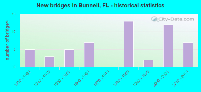
- New bridges - historical statistics
- 51930-1939
- 31940-1949
- 51950-1959
- 71960-1969
- 131980-1989
- 21990-1999
- 122000-2009
- 72010-2019

- Reconstructed bridges - Historical Statistics
- 11970-1979
- 11980-1989
- 71990-1999
- 02000-2009
- 12010-2019


- Bridge Condition - Deck
- 11.1%Very good
- 72.2%Good
- 13.9%Satisfactory
- 2.8%Fair

- Bridge Condition - Superstructure
- 16.7%Very good
- 58.3%Good
- 19.4%Satisfactory
- 5.6%Fair

- Bridge Condition - Substructure
- 13.9%Very good
- 63.9%Good
- 16.7%Satisfactory
- 5.6%Fair

- Bridge Condition - Channel
- 13.5%Very good
- 53.8%Good
- 21.2%Satisfactory
- 11.5%Fair

- Bridge Condition - Culverts
- 41.2%Good
- 58.8%Satisfactory
Find on map >> Show street view
Structure Number: 734085, Location: 3.7 miles North of CR-304 (Lat: 29.397269, Lng: -81.354003), Route carried "on" structure: County highway 305, Year Built: 2010, Status: Open, Structure Length: 1.52m (4.99ft), Average Daily Traffic: 700 (year 2019), Truck Traffic: 10%, Average Future Daily Traffic: 1,215 (year 2041), Design Load: HL 93, Features Intersected: Haw Creek
Minimum Vertical Clearance: 30.45m (99.90ft), Kilometerpoint: 5.998, Lanes on structure: 2, Owner: County Highway Agency, Approaching Roadway Width: 13.4m (44.0ft), Material/Design: Prestressed concrete, Design/Construction: Tee Beam, Number Of Spans In Main Unit: 1, Length of Maximum Span: 15.2m (49.9ft), Curb-To-Curb Width: 13.4m (44.0ft), Out-to-Out Width: 14.4m (47.2ft)
Condition: Deck: Good, Superstructure: Good, Substructure: Good, Channel: Good, Operating Rating: 65.7 metric tons, Method Used To Determine Operating Rating: Load and Resistance Factor (LRFR), Inventory Rating: 58.8 metric tons, Method Used To Determine Inventory Rating: Load and Resistance Factor (LRFR), Structural Evaluation: Better than present minimum criteria, Deck Geometry: Superior to present desirable criteria, Waterway Adequacy: Equal to present desirable criteria, Approach Roadway Alignment: Equal to present desirable criteria, Designated Inspection Frequency: Every 24 months, Inspection Date: October 2020, Deck Structure Type: Concrete Cast-file-Place
Find on map >> Show street view
Structure Number: 734086, Location: AT 3.1 MI N/O CR 304 (Lat: 29.386889, Lng: -81.353722), Route carried "on" structure: County highway 305, Year Built: 2014, Status: Open, Structure Length: 10.67m (35.01ft), Average Daily Traffic: 700 (year 2019), Truck Traffic: 60%, Average Future Daily Traffic: 1,045 (year 2034), Design Load: HL 93, Features Intersected: MIDDLE HAW CREEK
Minimum Vertical Clearance: 30+ m (98+ ft), Kilometerpoint: 4.807, Lanes on structure: 2, Owner: County Highway Agency, Approaching Roadway Width: 13.4m (44.0ft), Material/Design: Prestressed concrete, Design/Construction: Stringer/Multi-beam, Number Of Spans In Main Unit: 7, Length of Maximum Span: 15.2m (49.9ft), Curb-To-Curb Width: 13.4m (44.0ft), Out-to-Out Width: 14.3m (46.9ft)
Condition: Deck: Very good, Superstructure: Very good, Substructure: Very good, Channel: Very good, Operating Rating: 61.7 metric tons, Method Used To Determine Operating Rating: Load and Resistance Factor (LRFR), Inventory Rating: 54.9 metric tons, Method Used To Determine Inventory Rating: Load and Resistance Factor (LRFR), Structural Evaluation: Equal to present desirable criteria, Deck Geometry: Superior to present desirable criteria, Waterway Adequacy: Better than present minimum criteria, Approach Roadway Alignment: Equal to present desirable criteria, Designated Inspection Frequency: Every 24 months, Underwater Inspection Frequency: Every 24 months, Inspection Date: December 2020, Underwater Inspection Date: December 2020, Deck Structure Type: Concrete Cast-file-Place
Find on map >> Show street view
Structure Number: 760021, Location: 3.5 MI. SE. OF US-17 (Lat: 29.570000, Lng: -81.548889), Route carried "on" structure: State highway 100, Year Built: 1933, Year Reconstructed: 2001, Status: Open, Structure Length: 0.64m (2.10ft), Average Daily Traffic: 4,800 (year 2020), Truck Traffic: 14%, Average Future Daily Traffic: 8,328 (year 2042), Design Load: HS 20+Mod, Features Intersected: CANAL
Minimum Vertical Clearance: 30+ m (98+ ft), Kilometerpoint: 5.440, Lanes on structure: 2, Owner: State Highway Agency, Approaching Roadway Width: 10.5m (34.4ft), Material/Design: Concrete, Design/Construction: Culvert, Number Of Spans In Main Unit: 2, Length of Maximum Span: 3.4m (11.2ft)
Condition: Channel: Good, Culverts: Satisfactory, Operating Rating: 54.6 metric tons, Method Used To Determine Operating Rating: Load Factor (LF), Inventory Rating: 32.7 metric tons, Method Used To Determine Inventory Rating: Load Factor (LF), Structural Evaluation: Equal to present minimum criteria, Waterway Adequacy: Equal to present desirable criteria, Approach Roadway Alignment: Equal to present desirable criteria, Designated Inspection Frequency: Every 24 months, Inspection Date: Febuary 2022
Find on map >> Show street view
Structure Number: 790017, Location: 0.6 Mi W of SR-11 (Lat: 29.221953, Lng: -81.330042), Route carried "on" structure: State highway 40, Year Built: 1965, Status: Open, Structure Length: 0.88m (2.89ft), Average Daily Traffic: 6,700 (year 2020), Truck Traffic: 12%, Average Future Daily Traffic: 11,625 (year 2042), Design Load: HS 20+Mod, Features Intersected: Canal
Minimum Vertical Clearance: 30+ m (98+ ft), Kilometerpoint: 20.180, Lanes on structure: 2, Base Highway Network: Yes, Owner: State Highway Agency, Approaching Roadway Width: 10.1m (33.1ft), Material/Design: Concrete, Design/Construction: Culvert, Number Of Spans In Main Unit: 3, Length of Maximum Span: 2.7m (8.9ft)
Condition: Channel: Good, Culverts: Good, Operating Rating: 63.6 metric tons, Method Used To Determine Operating Rating: Load Factor (LF), Inventory Rating: 38.1 metric tons, Method Used To Determine Inventory Rating: Load Factor (LF), Structural Evaluation: Better than present minimum criteria, Waterway Adequacy: Equal to present desirable criteria, Approach Roadway Alignment: Equal to present desirable criteria, Length Of Structure Improvement: 1.87m (6.14ft), Designated Inspection Frequency: Every 24 months, Inspection Date: July 2021, Bridge Improvement Cost: $35,000, Total Project Cost: $313,000
Find on map >> Show street view
Structure Number: 790018, Location: SR-40 - Little Haw Creek (Lat: 29.226672, Lng: -81.311033), Route carried "on" structure: State highway 40, Year Built: 1965, Status: Open, Structure Length: 4.63m (15.19ft), Average Daily Traffic: 6,700 (year 2020), Truck Traffic: 13%, Average Future Daily Traffic: 11,624 (year 2042), Design Load: H 20, Features Intersected: Little Haw Creek
Minimum Vertical Clearance: 30+ m (98+ ft), Kilometerpoint: 22.120, Lanes on structure: 2, Base Highway Network: Yes, Owner: State Highway Agency, Approaching Roadway Width: 9.6m (31.5ft), Material/Design: Concrete, Design/Construction: Slab, Number Of Spans In Main Unit: 5, Length of Maximum Span: 9.1m (29.9ft), Curb-To-Curb Width: 13.0m (42.7ft), Out-to-Out Width: 14.1m (46.3ft)
Condition: Deck: Good, Superstructure: Good, Substructure: Satisfactory, Channel: Good, Operating Rating: 41.8 metric tons, Method Used To Determine Operating Rating: Load and Resistance Factor (LRFR), Inventory Rating: 32.3 metric tons, Method Used To Determine Inventory Rating: Load and Resistance Factor (LRFR), Structural Evaluation: Equal to present minimum criteria, Deck Geometry: Somewhat better than minimum adequacy, Waterway Adequacy: Equal to present desirable criteria, Approach Roadway Alignment: Equal to present desirable criteria, Designated Inspection Frequency: Every 24 months, Underwater Inspection Frequency: Every 24 months, Inspection Date: Febuary 2021, Underwater Inspection Date: March 2021, Deck Structure Type: Concrete Cast-file-Place, Wearing Surface/Protective System: Wearing Surface: Monolithic Concrete
Find on map >> Show street view
Structure Number: 790019, Location: SR-40 - Middle Haw Creek (Lat: 29.241131, Lng: -81.230083), Route carried "on" structure: State highway 40, Year Built: 1965, Status: Open, Structure Length: 3.72m (12.20ft), Average Daily Traffic: 6,700 (year 2020), Truck Traffic: 13%, Average Future Daily Traffic: 11,624 (year 2042), Design Load: HS 20, Features Intersected: Middle Haw Creek
Minimum Vertical Clearance: 30+ m (98+ ft), Kilometerpoint: 30.252, Lanes on structure: 2, Base Highway Network: Yes, Owner: State Highway Agency, Approaching Roadway Width: 9.6m (31.5ft), Material/Design: Concrete, Design/Construction: Slab, Number Of Spans In Main Unit: 4, Length of Maximum Span: 9.1m (29.9ft), Curb-To-Curb Width: 13.0m (42.7ft), Out-to-Out Width: 14.0m (45.9ft)
Condition: Deck: Satisfactory, Superstructure: Satisfactory, Substructure: Satisfactory, Channel: Good, Operating Rating: 66.8 metric tons, Method Used To Determine Operating Rating: Load Factor (LF), Inventory Rating: 40.0 metric tons, Method Used To Determine Inventory Rating: Load Factor (LF), Structural Evaluation: Equal to present minimum criteria, Deck Geometry: Somewhat better than minimum adequacy, Waterway Adequacy: Equal to present desirable criteria, Approach Roadway Alignment: Equal to present desirable criteria, Designated Inspection Frequency: Every 24 months, Underwater Inspection Frequency: Every 24 months, Inspection Date: January 2021, Underwater Inspection Date: January 2021, Deck Structure Type: Concrete Cast-file-Place, Wearing Surface/Protective System: Wearing Surface: Monolithic Concrete
Find on map >> Show street view
Structure Number: 790095, Location: 0.6 Mi S of Flagler Co. (Lat: 29.254347, Lng: -81.327150), Route carried "on" structure: State highway 11, Year Built: 1959, Status: Open, Structure Length: 0.64m (2.10ft), Average Daily Traffic: 3,900 (year 2020), Truck Traffic: 12%, Average Future Daily Traffic: 6,766 (year 2042), Design Load: H 15, Features Intersected: Creek
Minimum Vertical Clearance: 30+ m (98+ ft), Kilometerpoint: 21.927, Lanes on structure: 2, Owner: State Highway Agency, Approaching Roadway Width: 10.3m (33.8ft), Material/Design: Concrete, Design/Construction: Culvert, Number Of Spans In Main Unit: 2, Length of Maximum Span: 3.0m (9.8ft)
Condition: Channel: Good, Culverts: Satisfactory, Operating Rating: 60.4 metric tons, Method Used To Determine Operating Rating: Load Factor (LF), Inventory Rating: 36.2 metric tons, Method Used To Determine Inventory Rating: Load Factor (LF), Structural Evaluation: Equal to present minimum criteria, Waterway Adequacy: Equal to present desirable criteria, Approach Roadway Alignment: Equal to present desirable criteria, Designated Inspection Frequency: Every 24 months, Inspection Date: March 2020
Find on map >> Show street view
Structure Number: 795, Location: 0.3 Mi. S. of Mason Ave. (Lat: 29.225331, Lng: -81.023261), Route carried "on" structure: City street 4011, Year Built: 1955, Status: Posted for load, Structure Length: 1.01m (3.31ft), Average Daily Traffic: 4,100 (year 2021), Truck Traffic: 5%, Average Future Daily Traffic: 7,113 (year 2042), Features Intersected: Daytona Canal, Facility Carried by Structure: Ballough Street
Minimum Vertical Clearance: 30+ m (98+ ft), Kilometerpoint: 1.986, Lanes on structure: 2, Owner: City or Municipal Highway Agency, Approaching Roadway Width: 12.2m (40.0ft), Material/Design: Concrete, Design/Construction: Frame, Number Of Spans In Main Unit: 1, Length of Maximum Span: 10.1m (33.1ft), Curb or Sidewalk Widths: Left: 1.6m (5.2ft), Right: 1.6m (5.2ft), Curb-To-Curb Width: 12.2m (40.0ft), Out-to-Out Width: 16.2m (53.1ft)
Condition: Deck: Fair, Superstructure: Fair, Substructure: Fair, Channel: Good, Operating Rating: 22.6 metric tons, Method Used To Determine Operating Rating: Load Factor (LF), Inventory Rating: 13.5 metric tons, Method Used To Determine Inventory Rating: Load Factor (LF), Structural Evaluation: Meets minimum limits, Deck Geometry: Equal to present minimum criteria, Waterway Adequacy: Equal to present desirable criteria, Approach Roadway Alignment: Equal to present desirable criteria, Bridge Posting: Required (Relationship of Operating Rating to Maximum Legal Load: > 39.9% below), Designated Inspection Frequency: Every 24 months, Other Special Inspection Frequency: Every 12 months, Inspection Date: May 2020, Other Special Inspection Date: May 2021, Deck Structure Type: Concrete Cast-file-Place
Find on map >> Show street view
Structure Number: 730068, Location: SR-100 over US-1 (Lat: 29.472153, Lng: -81.266786), Route carried "under" structure: US 5, Year Built: 2002, Structure Length: 0. m, Average Daily Traffic: 17,100 (year 2020), Truck Traffic: 11%, Features Intersected: US-1, Facility Carried by Structure: SR-100
Minimum Vertical Clearance: 6.46m (21.19ft), Kilometerpoint: 17.724, Lanes on structure: 2, Lanes under structure: 4, Material/Design: Prestressed concrete, Design/Construction: Stringer/Multi-beam, Length of Maximum Span: 42.7m (140.1ft)