Bridge Statistics for Canton, Georgia (GA)
Condition, Traffic, Stress, Structural Evaluation, Project Costs
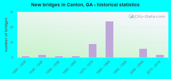
- New bridges - historical statistics
- 11930-1939
- 21940-1949
- 11950-1959
- 11960-1969
- 91970-1979
- 241980-1989
- 62000-2009
- 22010-2019
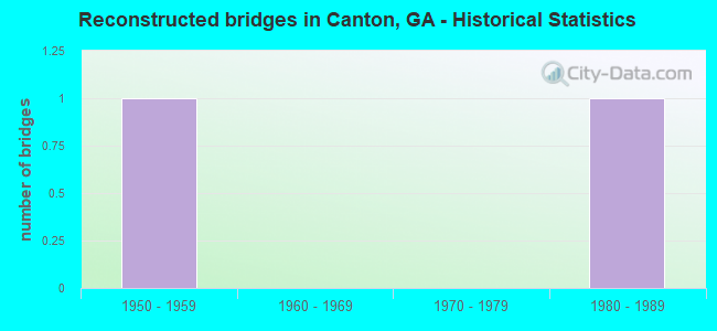
- Reconstructed bridges - Historical Statistics
- 11950-1959
- 01960-1969
- 01970-1979
- 11980-1989
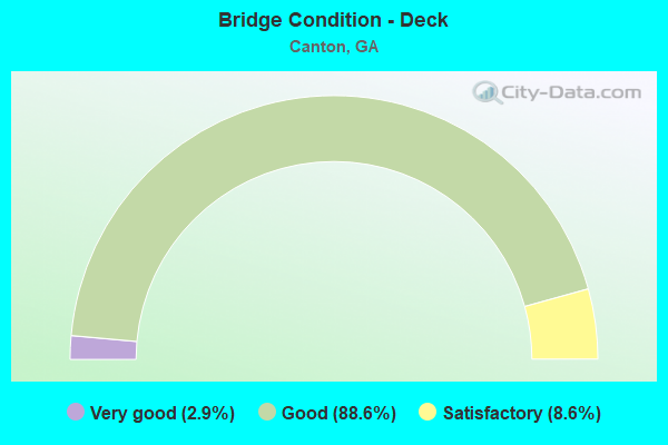
- Bridge Condition - Deck
- 2.9%Very good
- 88.6%Good
- 8.6%Satisfactory
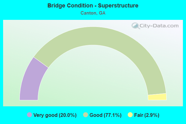
- Bridge Condition - Superstructure
- 20.0%Very good
- 77.1%Good
- 2.9%Fair
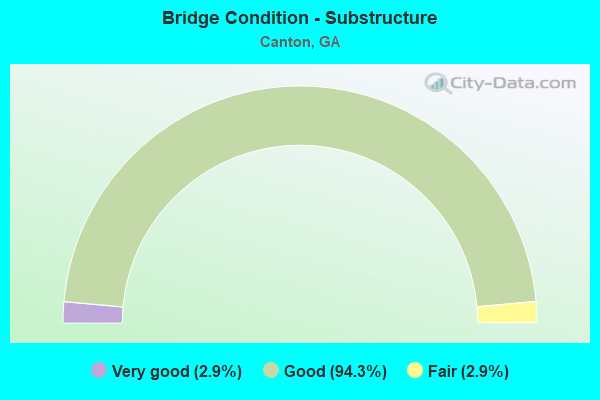
- Bridge Condition - Substructure
- 2.9%Very good
- 94.3%Good
- 2.9%Fair
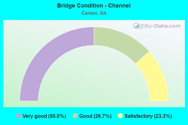
- Bridge Condition - Channel
- 50.0%Very good
- 26.7%Good
- 23.3%Satisfactory

- Bridge Condition - Culverts
- 63.6%Good
- 18.2%Satisfactory
- 18.2%Fair
Find on map >> Show street view
Structure Number: 575088, Location: 3.0 MI W OF HOLLY SPRINGS (Lat: 34.199597, Lng: -84.540678), Route carried "on" structure: County highway 2568, Year Built: 2001, Status: Open, Structure Length: 1.86m (6.10ft), Average Daily Traffic: 2,202 (year 2011), Truck Traffic: 1%, Average Future Daily Traffic: 3,303 (year 2031), Design Load: H 15, Features Intersected: DOWNING CREEK, Facility Carried by Structure: GOLD BRIDGE CROSSI
Minimum Vertical Clearance: 30+ m (98+ ft), Kilometerpoint: 0.000, Lanes on structure: 2, Base Highway Network: Yes, Owner: County Highway Agency, Approaching Roadway Width: 7.0m (23.0ft), Material/Design: Steel, Design/Construction: Stringer/Multi-beam, Number Of Spans In Main Unit: 1, Length of Maximum Span: 18.6m (61.0ft), Curb-To-Curb Width: 8.8m (28.9ft), Out-to-Out Width: 9.6m (31.5ft)
Condition: Deck: Very good, Superstructure: Very good, Substructure: Good, Channel: Very good, Operating Rating: 73.4 metric tons, Method Used To Determine Operating Rating: Load Factor (LF), Inventory Rating: 44.4 metric tons, Method Used To Determine Inventory Rating: Load Factor (LF), Structural Evaluation: Better than present minimum criteria, Deck Geometry: Meets minimum limits, Waterway Adequacy: Equal to present desirable criteria, Approach Roadway Alignment: Equal to present desirable criteria, Designated Inspection Frequency: Every 24 months, Inspection Date: March 2020, Bridge Improvement Cost: $238,000, Roadway Improvement Cost: $24,000, Total Project Cost: $358,000, Deck Structure Type: Concrete Cast-file-Place, Wearing Surface/Protective System: Wearing Surface: Bituminous
Find on map >> Show street view
Structure Number: 575089, Location: 2.8 MI W OF HOLLY SPRINGS (Lat: 34.182028, Lng: -84.551258), Route carried "on" structure: County highway 2496, Year Built: 2003, Status: Open, Structure Length: 0.64m (2.10ft), Average Daily Traffic: 9,520 (year 2011), Truck Traffic: 3%, Average Future Daily Traffic: 14,280 (year 2031), Design Load: H 15, Features Intersected: ALLATOONA CREEK TRIB, Facility Carried by Structure: BRIDGE MILL AVENUE
Minimum Vertical Clearance: 30+ m (98+ ft), Kilometerpoint: 3.219, Lanes on structure: 2, Base Highway Network: Yes, Owner: County Highway Agency, Approaching Roadway Width: 7.0m (23.0ft), Material/Design: Concrete, Design/Construction: Culvert, Number Of Spans In Main Unit: 2, Length of Maximum Span: 3.0m (9.8ft), Curb or Sidewalk Widths: Left: 2.4m (7.9ft), Right: 0.0m
Condition: Channel: Very good, Culverts: Good, Structural Evaluation: Better than present minimum criteria, Waterway Adequacy: Equal to present desirable criteria, Approach Roadway Alignment: Equal to present desirable criteria, Designated Inspection Frequency: Every 24 months, Inspection Date: March 2020, Bridge Improvement Cost: $82,000, Roadway Improvement Cost: $8,000, Total Project Cost: $123,000
Find on map >> Show street view
Structure Number: 575095, Location: IN EAST CANTON (Lat: 34.236519, Lng: -84.464444), Route carried "on" structure: Ramp Interstate 575, Year Built: 2007, Status: Open, Structure Length: 11.06m (36.29ft), Average Daily Traffic: 17,280 (year 2008), Truck Traffic: 1%, Average Future Daily Traffic: 25,920 (year 2031), Design Load: HS 20+Mod, Features Intersected: CANTON CREEK TRIB, Facility Carried by Structure: RAMP TO SR 20 EBL
Minimum Vertical Clearance: 30+ m (98+ ft), Kilometerpoint: 0.000, Lanes on structure: 1, Owner: State Highway Agency, Approaching Roadway Width: 10.4m (34.1ft), Material/Design: Prestressed concrete, Design/Construction: Stringer/Multi-beam, Number Of Spans In Main Unit: 3, Length of Maximum Span: 36.9m (121.1ft), Curb-To-Curb Width: 10.4m (34.1ft), Out-to-Out Width: 11.2m (36.7ft)
Condition: Deck: Good, Superstructure: Very good, Substructure: Good, Channel: Very good, Operating Rating: 89.8 metric tons, Method Used To Determine Operating Rating: Load Factor (LF), Inventory Rating: 22.6 metric tons, Method Used To Determine Inventory Rating: Load Factor (LF), Structural Evaluation: Somewhat better than minimum adequacy, Deck Geometry: Superior to present desirable criteria, Waterway Adequacy: Equal to present desirable criteria, Approach Roadway Alignment: Better than present minimum criteria, Designated Inspection Frequency: Every 24 months, Inspection Date: May 2020, Bridge Improvement Cost: $1,032,000, Roadway Improvement Cost: $103,000, Total Project Cost: $1,547,000, Deck Structure Type: Concrete Cast-file-Place
Find on map >> Show street view
Structure Number: 575108, Location: 1.6 MI E OF CANTON (Lat: 34.230100, Lng: -84.460131), Route carried "on" structure: Alternate County highway 621, Year Built: 2013, Status: Open, Structure Length: 11.06m (36.29ft), Average Daily Traffic: 26,640 (year 2007), Truck Traffic: 3%, Average Future Daily Traffic: 30,000 (year 2012), Design Load: HS 20+Mod, Features Intersected: CANTON CREEK, Facility Carried by Structure: NORTHSIDE CHEROKEE
Minimum Vertical Clearance: 30+ m (98+ ft), Kilometerpoint: 1.609, Lanes on structure: 2, Owner: State Highway Agency, Approaching Roadway Width: 8.5m (27.9ft), Skew: 1 degrees, Material/Design: Prestressed concrete, Design/Construction: Stringer/Multi-beam, Number Of Spans In Main Unit: 3, Length of Maximum Span: 42.1m (138.1ft), Curb or Sidewalk Widths: Left: 1.8m (5.9ft), Right: 0.0m, Curb-To-Curb Width: 9.1m (29.9ft), Out-to-Out Width: 12.5m (41.0ft)
Condition: Deck: Good, Superstructure: Very good, Substructure: Good, Channel: Very good, Operating Rating: 44.4 metric tons, Method Used To Determine Operating Rating: Load Factor (LF), Inventory Rating: 26.3 metric tons, Method Used To Determine Inventory Rating: Load Factor (LF), Structural Evaluation: Equal to present minimum criteria, Deck Geometry: High priority of corrective action, Waterway Adequacy: Superior to present desirable criteria, Approach Roadway Alignment: Better than present minimum criteria, Length Of Structure Improvement: 13.29m (43.60ft), Designated Inspection Frequency: Every 24 months, Inspection Date: May 2020, Bridge Improvement Cost: $32,264,000, Roadway Improvement Cost: $3,226,000, Total Project Cost: $48,396,000 ( Estimate for 2018), Deck Structure Type: Concrete Cast-file-Place
Find on map >> Show street view
Structure Number: 575109, Location: 1.6 MI E OF CANTON (Lat: 34.229847, Lng: -84.459981), Route carried "on" structure: Alternate County highway 621, Year Built: 2013, Status: Open, Structure Length: 11.06m (36.29ft), Average Daily Traffic: 26,640 (year 2007), Truck Traffic: 3%, Average Future Daily Traffic: 30,000 (year 2012), Design Load: HS 20+Mod, Features Intersected: CANTON CREEK, Facility Carried by Structure: NORTHSIDE CHEROKEE
Minimum Vertical Clearance: 30+ m (98+ ft), Kilometerpoint: 1.609, Lanes on structure: 2, Owner: State Highway Agency, Approaching Roadway Width: 8.5m (27.9ft), Skew: 1 degrees, Material/Design: Prestressed concrete, Design/Construction: Stringer/Multi-beam, Number Of Spans In Main Unit: 3, Length of Maximum Span: 42.1m (138.1ft), Curb or Sidewalk Widths: Left: 0.0m, Right: 1.8m (5.9ft), Curb-To-Curb Width: 9.1m (29.9ft), Out-to-Out Width: 12.5m (41.0ft)
Condition: Deck: Good, Superstructure: Very good, Substructure: Good, Channel: Very good, Operating Rating: 45.3 metric tons, Method Used To Determine Operating Rating: Load Factor (LF), Inventory Rating: 27.2 metric tons, Method Used To Determine Inventory Rating: Load Factor (LF), Structural Evaluation: Equal to present minimum criteria, Deck Geometry: High priority of corrective action, Waterway Adequacy: Superior to present desirable criteria, Approach Roadway Alignment: Better than present minimum criteria, Length Of Structure Improvement: 13.29m (43.60ft), Designated Inspection Frequency: Every 24 months, Inspection Date: May 2020, Bridge Improvement Cost: $32,264,000, Roadway Improvement Cost: $3,226,000, Total Project Cost: $48,396,000 ( Estimate for 2018), Deck Structure Type: Concrete Cast-file-Place
Find on map >> Show street view
Structure Number: 570006, Location: 1.9 MI NE OF CANTON (Lat: 34.254058, Lng: -84.467169), Route carried "under" structure: Interstate 575, Structure Length: 0. m, Average Daily Traffic: 19,600 (year 1999), Truck Traffic: 1%, Features Intersected: SR 5 BUSINESS, Facility Carried by Structure: SR 5 BUSINESS
Minimum Vertical Clearance: 5.56m (18.24ft), Kilometerpoint: 32.187, Lanes on structure: 5, Length of Maximum Span: 0.0m
Find on map >> Show street view
Structure Number: 570011, Location: LEVEL 2 OF TRI-LEVEL (Lat: 34.219439, Lng: -84.489378), Route carried "under" structure: Interstate 575, Structure Length: 0. m, Average Daily Traffic: 34,300 (year 1999), Truck Traffic: 1%, Features Intersected: SR 20 (EBL) (A-588), Facility Carried by Structure: SR20 (EBL) (A-588)
Minimum Vertical Clearance: 5.51m (18.08ft), Kilometerpoint: 27.359, Lanes on structure: 2, Length of Maximum Span: 0.0m
Find on map >> Show street view
Structure Number: 570012, Location: IN EAST CANTON (Lat: 34.238058, Lng: -84.466069), Route carried "under" structure: Ramp Interstate 575, Structure Length: 0. m, Average Daily Traffic: 32,200 (year 2007), Truck Traffic: 1%, Features Intersected: SR 20 EBL, Facility Carried by Structure: SR 20 (EBL)
Minimum Vertical Clearance: 5.51m (18.08ft), Kilometerpoint: 30.578, Lanes on structure: 2, Length of Maximum Span: 0.0m
Find on map >> Show street view
Structure Number: 570012, Location: IN EAST CANTON (Lat: 34.238058, Lng: -84.466069), Route carried "under" structure: Ramp Interstate 575, Structure Length: 0. m, Average Daily Traffic: 32,200 (year 2007), Truck Traffic: 1%, Features Intersected: SR 20 EBL, Facility Carried by Structure: SR 20 (EBL)
Minimum Vertical Clearance: 6.42m (21.06ft), Kilometerpoint: 30.578, Lanes on structure: 2, Length of Maximum Span: 0.0m
Find on map >> Show street view
Structure Number: 570012, Location: IN EAST CANTON (Lat: 34.238058, Lng: -84.466069), Route carried "under" structure: Interstate 575, Structure Length: 0. m, Average Daily Traffic: 32,200 (year 2007), Truck Traffic: 1%, Features Intersected: SR 20 EBL, Facility Carried by Structure: SR 20 (EBL)
Minimum Vertical Clearance: 5.81m (19.06ft), Kilometerpoint: 30.578, Lanes on structure: 2, Length of Maximum Span: 0.0m
Find on map >> Show street view
Structure Number: 570013, Location: IN EAST CANTON (Lat: 34.238319, Lng: -84.466008), Route carried "under" structure: Ramp Interstate 575, Structure Length: 0. m, Average Daily Traffic: 20,500 (year 2007), Truck Traffic: 8%, Features Intersected: SR 20 WBL, Facility Carried by Structure: SR 20 (WBL)
Minimum Vertical Clearance: 5.63m (18.47ft), Kilometerpoint: 30.578, Lanes on structure: 2, Length of Maximum Span: 0.0m
Find on map >> Show street view
Structure Number: 570013, Location: IN EAST CANTON (Lat: 34.238319, Lng: -84.466008), Route carried "under" structure: Interstate 575, Structure Length: 0. m, Average Daily Traffic: 20,500 (year 2007), Truck Traffic: 8%, Features Intersected: SR 20 WBL, Facility Carried by Structure: SR 20 (WBL)
Minimum Vertical Clearance: 5.53m (18.14ft), Kilometerpoint: 30.578, Lanes on structure: 2, Length of Maximum Span: 0.0m
Find on map >> Show street view
Structure Number: 570013, Location: IN EAST CANTON (Lat: 34.238319, Lng: -84.466008), Route carried "under" structure: Ramp Interstate 575, Structure Length: 0. m, Average Daily Traffic: 20,500 (year 2007), Truck Traffic: 8%, Features Intersected: SR 20 WBL, Facility Carried by Structure: SR 20 (WBL)
Minimum Vertical Clearance: 5.84m (19.16ft), Kilometerpoint: 30.578, Lanes on structure: 2, Length of Maximum Span: 0.0m
Find on map >> Show street view
Structure Number: 570031, Location: 1.5 MI N OF HOLLY SPRGS (Lat: 34.197400, Lng: -84.501528), Route carried "under" structure: Interstate 575, Structure Length: 0. m, Average Daily Traffic: 34,300 (year 1999), Truck Traffic: 1%, Features Intersected: CR 309 UNIVETER ROAD, Facility Carried by Structure: UNIVETER ROAD
Minimum Vertical Clearance: 5.41m (17.75ft), Kilometerpoint: 24.140, Lanes on structure: 2, Length of Maximum Span: 0.0m
Find on map >> Show street view
Structure Number: 570032, Location: IN SOUTH CANTON (Lat: 34.219997, Lng: -84.491439), Route carried "under" structure: State highway 20, Structure Length: 0. m, Average Daily Traffic: 16,400 (year 1999), Truck Traffic: 1%, Features Intersected: CR 341 KILLIAN STREET, Facility Carried by Structure: KILLIAN STREET
Minimum Vertical Clearance: 7.11m (23.33ft), Kilometerpoint: 16.093, Lanes on structure: 2, Length of Maximum Span: 0.0m
Find on map >> Show street view
Structure Number: 570032, Location: IN SOUTH CANTON (Lat: 34.219997, Lng: -84.491439), Route carried "under" structure: Ramp State highway 20, Structure Length: 0. m, Average Daily Traffic: 2,200 (year 1990), Truck Traffic: 1%, Features Intersected: CR 341 KILLIAN STREET, Facility Carried by Structure: KILLIAN STREET
Minimum Vertical Clearance: 5.74m (18.83ft), Kilometerpoint: 16.093, Lanes on structure: 2, Length of Maximum Span: 0.0m
Find on map >> Show street view
Structure Number: 570033, Location: 1.7 MI S OF CANTON (Lat: 34.211158, Lng: -84.491989), Route carried "under" structure: Interstate 575, Structure Length: 0. m, Average Daily Traffic: 34,300 (year 1999), Truck Traffic: 1%, Features Intersected: CR 333 MCHELEN ROAD, Facility Carried by Structure: BRICK MILL ROAD
Minimum Vertical Clearance: 5.66m (18.57ft), Kilometerpoint: 25.750, Lanes on structure: 2, Length of Maximum Span: 0.0m
Find on map >> Show street view
Structure Number: 570046, Location: IN SOUTH CANTON (Lat: 34.223519, Lng: -84.484228), Route carried "under" structure: State highway 140, Structure Length: 0. m, Average Daily Traffic: 6,550 (year 1999), Truck Traffic: 1%, Features Intersected: SR 417 (I-575) NBL, Facility Carried by Structure: I-575 (NBL)
Minimum Vertical Clearance: 5.13m (16.83ft), Kilometerpoint: 25.750, Lanes on structure: 3, Length of Maximum Span: 0.0m
Find on map >> Show street view
Structure Number: 570047, Location: IN SOUTH CANTON (Lat: 34.223689, Lng: -84.484469), Route carried "under" structure: State highway 140, Structure Length: 0. m, Average Daily Traffic: 6,550 (year 1995), Truck Traffic: 1%, Features Intersected: SR 417 (I-575) SBL, Facility Carried by Structure: I-575 (SBL)
Minimum Vertical Clearance: 5.33m (17.49ft), Kilometerpoint: 25.750, Lanes on structure: 3, Length of Maximum Span: 0.0m
Find on map >> Show street view
Structure Number: 570055, Location: TOP OF TRI LEVEL (Lat: 34.219569, Lng: -84.489339), Route carried "under" structure: State highway 20, Structure Length: 0. m, Average Daily Traffic: 2,810 (year 1999), Truck Traffic: 1%, Features Intersected: RMP I-575 TO SR 20 WBL
Minimum Vertical Clearance: 5.41m (17.75ft), Kilometerpoint: 17.703, Lanes on structure: 1, Length of Maximum Span: 0.0m
Find on map >> Show street view
Structure Number: 570071, Location: IN SOUTH CANTON (Lat: 34.220889, Lng: -84.496308), Route carried "under" structure: State highway 20, Structure Length: 0. m, Average Daily Traffic: 16,400 (year 1999), Truck Traffic: 1%, Features Intersected: FAS 1375 MARIETTA STREET, Facility Carried by Structure: MARIETTA STREET
Minimum Vertical Clearance: 9.52m (31.23ft), Kilometerpoint: 16.093, Lanes on structure: 2, Length of Maximum Span: 0.0m
Find on map >> Show street view
Structure Number: 570076, Location: 4.9 MI NE OF CANTON (Lat: 34.292228, Lng: -84.436339), Route carried "under" structure: Interstate 575, Structure Length: 0. m, Average Daily Traffic: 19,600 (year 1999), Truck Traffic: 1%, Features Intersected: CR 55 LOWER BETHANY RD, Facility Carried by Structure: LOWER BETHANY RD
Minimum Vertical Clearance: 7.95m (26.08ft), Kilometerpoint: 37.015, Lanes on structure: 2, Length of Maximum Span: 0.0m
Find on map >> Show street view
Structure Number: 570077, Location: 3.8 MI NE OF CANTON (Lat: 34.280878, Lng: -84.450528), Route carried "under" structure: Interstate 575, Structure Length: 0. m, Average Daily Traffic: 19,600 (year 1999), Truck Traffic: 1%, Features Intersected: CR 86 OLD PAGE PLACE RD, Facility Carried by Structure: OLD PAGE PLACE RD
Minimum Vertical Clearance: 5.43m (17.81ft), Kilometerpoint: 35.406, Lanes on structure: 2, Length of Maximum Span: 0.0m
Find on map >> Show street view
Structure Number: 570078, Location: 3.8 MI NE OF CANTON (Lat: 34.282389, Lng: -84.450939), Route carried "under" structure: Interstate 575, Structure Length: 0. m, Average Daily Traffic: 19,600 (year 1999), Truck Traffic: 1%, Features Intersected: CR 86 OLD PAGE PLACE RD., Facility Carried by Structure: OLD PAGE PLACE RD
Minimum Vertical Clearance: 6.22m (20.41ft), Kilometerpoint: 35.406, Lanes on structure: 2, Length of Maximum Span: 0.0m
Find on map >> Show street view
Structure Number: 570079, Location: 3.2 MI NE OF CANTON (Lat: 34.276039, Lng: -84.459619), Route carried "under" structure: Interstate 575, Structure Length: 0. m, Average Daily Traffic: 19,600 (year 1999), Truck Traffic: 1%, Features Intersected: CR100 CHARLIE BURGESS DR, Facility Carried by Structure: OLD VANDIEVER DR
Minimum Vertical Clearance: 5.30m (17.39ft), Kilometerpoint: 35.406, Lanes on structure: 2, Length of Maximum Span: 0.0m
Find on map >> Show street view
Structure Number: 57008, Location: 3.2 MI NE OF CANTON (Lat: 34.274408, Lng: -84.458978), Route carried "under" structure: Interstate 575, Structure Length: 0. m, Average Daily Traffic: 19,600 (year 1999), Truck Traffic: 1%, Features Intersected: CR100 CHARLIE BURGESS DR, Facility Carried by Structure: OLD VANDIEVER DR
Minimum Vertical Clearance: 5.20m (17.06ft), Kilometerpoint: 35.406, Lanes on structure: 2, Length of Maximum Span: 0.0m