Bridge Statistics for Ceres, California (CA)
Condition, Traffic, Stress, Structural Evaluation, Project Costs
- National Bridge Inventory (NBI) Statistics
- 35Number of bridges
- 413ft / 126mTotal length
- $3,028,000Total costs
- 888,897Total average daily traffic
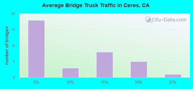
- 111,593Total average daily truck traffic
- National Bridge Inventory (NBI) Registered Bridges for Ceres
- No street view available for this location
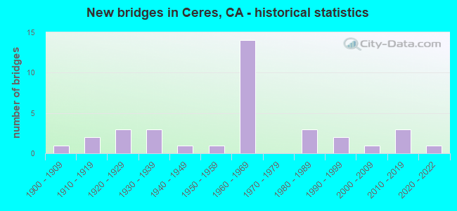
- New bridges - historical statistics
- 11900-1909
- 21910-1919
- 31920-1929
- 31930-1939
- 11940-1949
- 11950-1959
- 141960-1969
- 31980-1989
- 21990-1999
- 12000-2009
- 32010-2019
- 12020-2022
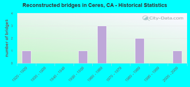
- Reconstructed bridges - Historical Statistics
- 11920-1929
- 01930-1939
- 01940-1949
- 11950-1959
- 31960-1969
- 01970-1979
- 21980-1989
- 01990-1999
- 12000-2009

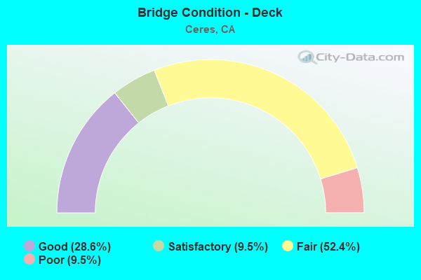
- Bridge Condition - Deck
- 28.6%Good
- 9.5%Satisfactory
- 52.4%Fair
- 9.5%Poor
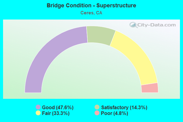
- Bridge Condition - Superstructure
- 47.6%Good
- 14.3%Satisfactory
- 33.3%Fair
- 4.8%Poor
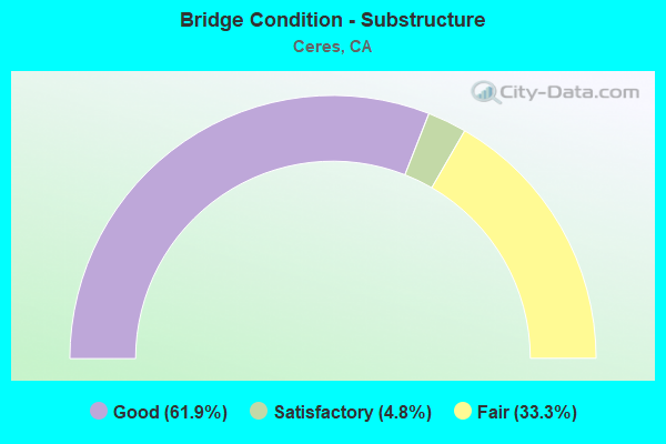
- Bridge Condition - Substructure
- 61.9%Good
- 4.8%Satisfactory
- 33.3%Fair
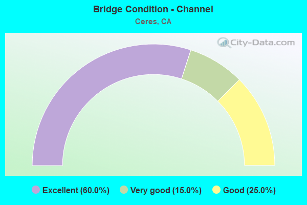
- Bridge Condition - Channel
- 60.0%Excellent
- 15.0%Very good
- 25.0%Good
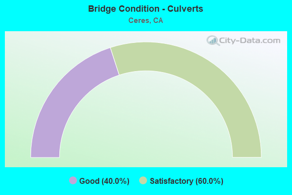
- Bridge Condition - Culverts
- 40.0%Good
- 60.0%Satisfactory
Find on map >> Show street view
Structure Number: 38 0007, Location: 10-STA-099-R10.03 (Lat: 37.574647, Lng: -120.937047), Route carried "on" structure: State highway 99, Year Built: 1941, Year Reconstructed: 1965, Status: Open, Structure Length: 1.00m (3.28ft), Average Daily Traffic: 96,000 (year 2011), Truck Traffic: 17%, Average Future Daily Traffic: 125,511 (year 2038), Design Load: HS 20, Features Intersected: CERES MAIN CANAL
Minimum Vertical Clearance: 30+ m (98+ ft), Kilometerpoint: 10.030, Lanes on structure: 6, Base Highway Network: Yes (, Subroute: 1), Owner: State Highway Agency, Approaching Roadway Width: 32.8m (107.6ft), Skew: 30 degrees, Material/Design: Concrete, Design/Construction: Slab, Number Of Spans In Main Unit: 1, Length of Maximum Span: 9.4m (30.8ft), Curb-To-Curb Width: 32.8m (107.6ft), Out-to-Out Width: 34.3m (112.5ft)
Condition: Deck: Satisfactory, Superstructure: Satisfactory, Substructure: Good, Channel: Good, Operating Rating: 66.7 metric tons, Method Used To Determine Operating Rating: Allowable Stress (AS), Inventory Rating: 38.6 metric tons, Method Used To Determine Inventory Rating: Allowable Stress (AS), Structural Evaluation: Equal to present minimum criteria, Deck Geometry: Superior to present desirable criteria, Waterway Adequacy: Equal to present desirable criteria, Approach Roadway Alignment: Equal to present desirable criteria, Designated Inspection Frequency: Every 24 months, Inspection Date: January 2021, Deck Structure Type: Concrete Cast-file-Place
Find on map >> Show street view
Structure Number: 38 0007K, Location: 10-STA-099-R10.03 (Lat: 37.574344, Lng: -120.937475), Route carried "on" structure: Ramp State highway 99, Year Built: 1912, Year Reconstructed: 1927, Status: Open, Structure Length: 0.92m (3.02ft), Average Daily Traffic: 7,400 (year 2000), Truck Traffic: 2%, Average Future Daily Traffic: 11,984 (year 2043), Features Intersected: CERES MAIN CANAL
Minimum Vertical Clearance: 30+ m (98+ ft), Kilometerpoint: 10.030, Lanes on structure: 1, Owner: State Highway Agency, Approaching Roadway Width: 7.0m (23.0ft), Material/Design: Concrete, Design/Construction: Slab, Number Of Spans In Main Unit: 2, Length of Maximum Span: 4.6m (15.1ft), Curb-To-Curb Width: 9.4m (30.8ft), Out-to-Out Width: 10.4m (34.1ft)
Condition: Deck: Good, Superstructure: Satisfactory, Substructure: Satisfactory, Channel: Good, Operating Rating: 26.9 metric tons, Method Used To Determine Operating Rating: Field evaluation and documented engineering judgment, Inventory Rating: 16.2 metric tons, Method Used To Determine Inventory Rating: Field evaluation and documented engineering judgment, Structural Evaluation: Meets minimum limits, Deck Geometry: Superior to present desirable criteria, Waterway Adequacy: Equal to present desirable criteria, Approach Roadway Alignment: Equal to present desirable criteria, Length Of Structure Improvement: 0.91m (2.99ft), Designated Inspection Frequency: Every 24 months, Inspection Date: January 2021, Deck Structure Type: Concrete Cast-file-Place, Wearing Surface/Protective System: Wearing Surface: Bituminous
Find on map >> Show street view
Structure Number: 38 0007S, Location: 10-STA-099-R10.03 (Lat: 37.574758, Lng: -120.936889), Route carried "on" structure: Ramp State highway 99, Year Built: 1965, Status: Open, Structure Length: 1.01m (3.31ft), Average Daily Traffic: 7,400 (year 2011), Truck Traffic: 2%, Average Future Daily Traffic: 11,747 (year 2041), Design Load: HS 20, Features Intersected: CERES MAIN CANAL
Minimum Vertical Clearance: 30+ m (98+ ft), Kilometerpoint: 10.030, Lanes on structure: 1, Owner: State Highway Agency, Approaching Roadway Width: 6.7m (22.0ft), Skew: 1 degrees, Material/Design: Concrete, Design/Construction: Slab, Number Of Spans In Main Unit: 1, Length of Maximum Span: 9.4m (30.8ft), Curb-To-Curb Width: 7.3m (24.0ft), Out-to-Out Width: 8.3m (27.2ft)
Condition: Deck: Satisfactory, Superstructure: Satisfactory, Substructure: Good, Channel: Very good, Operating Rating: 44.4 metric tons, Method Used To Determine Operating Rating: Load and Resistance Factor Rating (LRFR) rating reported by rating factor(RF) method using HL-93 loadings, Inventory Rating: 34.3 metric tons, Method Used To Determine Inventory Rating: Load and Resistance Factor Rating (LRFR) rating reported by rating factor(RF) method using HL-93 loadings, Structural Evaluation: Equal to present minimum criteria, Deck Geometry: Better than present minimum criteria, Waterway Adequacy: Equal to present desirable criteria, Approach Roadway Alignment: Equal to present desirable criteria, Designated Inspection Frequency: Every 48 months, Inspection Date: January 2021, Deck Structure Type: Concrete Cast-file-Place
Find on map >> Show street view
Structure Number: 38 0073, Location: 10-STA-099-R11.62-CER (Lat: 37.591481, Lng: -120.956331), Route carried "on" structure: State highway 99, Year Built: 1965, Status: Open, Structure Length: 4.69m (15.39ft), Average Daily Traffic: 101,000 (year 2011), Truck Traffic: 13%, Average Future Daily Traffic: 158,705 (year 2038), Design Load: HS 20, Features Intersected: SB 99-NORTH ST OFF RAMP
Minimum Vertical Clearance: 30+ m (98+ ft), Kilometerpoint: 11.620, Lanes on structure: 6, Lanes under structure: 2, Base Highway Network: Yes (, Subroute: 1), Owner: State Highway Agency, Approaching Roadway Width: 33.5m (109.9ft), Skew: 34 degrees, Material/Design: Concrete continuous, Design/Construction: Tee Beam, Number Of Spans In Main Unit: 3, Length of Maximum Span: 20.4m (66.9ft), Curb or Sidewalk Widths: Left: 0.0m, Right: 0.6m (2.0ft), Curb-To-Curb Width: 34.7m (113.8ft), Out-to-Out Width: 36.1m (118.4ft)
Condition: Deck: Poor, Superstructure: Good, Substructure: Good, Operating Rating: 43.4 metric tons, Method Used To Determine Operating Rating: Load and Resistance Factor Rating (LRFR) rating reported by rating factor(RF) method using HL-93 loadings, Inventory Rating: 30.8 metric tons, Method Used To Determine Inventory Rating: Load and Resistance Factor Rating (LRFR) rating reported by rating factor(RF) method using HL-93 loadings, Structural Evaluation: Better than present minimum criteria, Deck Geometry: Superior to present desirable criteria, Underclear: High priority of corrective action, Approach Roadway Alignment: Equal to present desirable criteria, Length Of Structure Improvement: 4.69m (15.39ft), Designated Inspection Frequency: Every 24 months, Inspection Date: March 2021, Bridge Improvement Cost: $1,692,000, Roadway Improvement Cost: $338,000, Total Project Cost: $2,842,000 ( Estimate for 2018), Deck Structure Type: Concrete Cast-file-Place
Find on map >> Show street view
Structure Number: 38 0074, Location: 10-STA-099-R11.30-CER (Lat: 37.587619, Lng: -120.953522), Route carried "on" structure: City street , Year Built: 1965, Status: Open, Structure Length: 11.64m (38.19ft), Average Daily Traffic: 12,000 (year 2011), Truck Traffic: 3%, Average Future Daily Traffic: 19,993 (year 2041), Design Load: HS 20+Mod, Features Intersected: SR 99,RAMP,STREET,UP RR, Facility Carried by Structure: PINE STREET
Minimum Vertical Clearance: 30+ m (98+ ft), Kilometerpoint: 0.000, Lanes on structure: 2, Lanes under structure: 9, Owner: State Highway Agency, Approaching Roadway Width: 14.3m (46.9ft), Skew: 1 degrees, Material/Design: Prestressed concrete continuous, Design/Construction: Stringer/Multi-beam, Number Of Spans In Main Unit: 4, Number Of Approach Spans: 2, Length of Maximum Span: 26.8m (87.9ft), Curb or Sidewalk Widths: Left: 1.5m (4.9ft), Right: 0.1m (0.3ft), Curb-To-Curb Width: 9.7m (31.8ft), Out-to-Out Width: 12.3m (40.4ft)
Condition: Deck: Good, Superstructure: Good, Substructure: Good, Operating Rating: 28.2 metric tons, Method Used To Determine Operating Rating: Load and Resistance Factor Rating (LRFR) rating reported by rating factor(RF) method using HL-93 loadings, Inventory Rating: 21.7 metric tons, Method Used To Determine Inventory Rating: Load and Resistance Factor Rating (LRFR) rating reported by rating factor(RF) method using HL-93 loadings, Structural Evaluation: Somewhat better than minimum adequacy, Deck Geometry: Meets minimum limits, Underclear: Equal to present minimum criteria, Approach Roadway Alignment: Superior to present desirable criteria, Designated Inspection Frequency: Every 24 months, Inspection Date: March 2021, Deck Structure Type: Concrete Cast-file-Place
Find on map >> Show street view
Structure Number: 38 0093, Location: 10-STA-099-R10.16 (Lat: 37.576186, Lng: -120.938561), Route carried "on" structure: State highway 99, Year Built: 1965, Status: Open, Structure Length: 4.88m (16.01ft), Average Daily Traffic: 96,000 (year 2009), Truck Traffic: 17%, Average Future Daily Traffic: 125,511 (year 2038), Design Load: HS 20+Mod, Features Intersected: MITCHELL RD
Minimum Vertical Clearance: 30+ m (98+ ft), Kilometerpoint: 10.160, Lanes on structure: 6, Lanes under structure: 2, Base Highway Network: Yes (, Subroute: 1), Owner: State Highway Agency, Approaching Roadway Width: 33.5m (109.9ft), Skew: 34 degrees, Material/Design: Concrete continuous, Design/Construction: Tee Beam, Number Of Spans In Main Unit: 3, Length of Maximum Span: 21.6m (70.9ft), Curb-To-Curb Width: 32.9m (107.9ft), Out-to-Out Width: 34.3m (112.5ft)
Condition: Deck: Fair, Superstructure: Good, Substructure: Good, Operating Rating: 41.5 metric tons, Method Used To Determine Operating Rating: Load and Resistance Factor Rating (LRFR) rating reported by rating factor(RF) method using HL-93 loadings, Inventory Rating: 32.1 metric tons, Method Used To Determine Inventory Rating: Load and Resistance Factor Rating (LRFR) rating reported by rating factor(RF) method using HL-93 loadings, Structural Evaluation: Better than present minimum criteria, Deck Geometry: Superior to present desirable criteria, Underclear: Meets minimum limits, Approach Roadway Alignment: Equal to present desirable criteria, Designated Inspection Frequency: Every 24 months, Inspection Date: March 2021, Deck Structure Type: Concrete Cast-file-Place
Find on map >> Show street view
Structure Number: 38 0094, Location: 10-STA-099-R10.58 (Lat: 37.580186, Lng: -120.944950), Route carried "on" structure: County highway , Year Built: 1965, Status: Open, Structure Length: 12.25m (40.19ft), Average Daily Traffic: 10,400 (year 2011), Truck Traffic: 3%, Average Future Daily Traffic: 15,862 (year 2038), Design Load: HS 20, Features Intersected: STATE ROUTE 99 & UP RR, Facility Carried by Structure: SERVICE RD
Minimum Vertical Clearance: 30+ m (98+ ft), Kilometerpoint: 0.000, Lanes on structure: 2, Lanes under structure: 6, Owner: State Highway Agency, Approaching Roadway Width: 10.1m (33.1ft), Skew: 4 degrees, Material/Design: Prestressed concrete continuous, Design/Construction: Stringer/Multi-beam, Number Of Spans In Main Unit: 4, Number Of Approach Spans: 2, Length of Maximum Span: 28.7m (94.2ft), Curb or Sidewalk Widths: Left: 1.5m (4.9ft), Right: 0.0m, Curb-To-Curb Width: 9.8m (32.2ft), Out-to-Out Width: 12.3m (40.4ft)
Condition: Deck: Fair, Superstructure: Good, Substructure: Good, Operating Rating: 34.3 metric tons, Method Used To Determine Operating Rating: Load and Resistance Factor Rating (LRFR) rating reported by rating factor(RF) method using HL-93 loadings, Inventory Rating: 26.6 metric tons, Method Used To Determine Inventory Rating: Load and Resistance Factor Rating (LRFR) rating reported by rating factor(RF) method using HL-93 loadings, Structural Evaluation: Equal to present minimum criteria, Deck Geometry: Meets minimum limits, Underclear: Equal to present minimum criteria, Approach Roadway Alignment: Superior to present desirable criteria, Designated Inspection Frequency: Every 24 months, Inspection Date: March 2021, Deck Structure Type: Concrete Cast-file-Place
Find on map >> Show street view
Structure Number: 38 0169, Location: 10-STA-099-R11.92 (Lat: 37.594494, Lng: -120.961194), Route carried "on" structure: City street , Year Built: 2011, Status: Open, Structure Length: 12.15m (39.86ft), Average Daily Traffic: 12,000 (year 2006), Truck Traffic: 3%, Average Future Daily Traffic: 20,329 (year 2041), Design Load: HS 20, Features Intersected: ST RTE 99, RAMP, & UP RR, Facility Carried by Structure: WHITMORE AVENUE
Minimum Vertical Clearance: 30+ m (98+ ft), Kilometerpoint: 0.000, Lanes on structure: 5, Lanes under structure: 8, Owner: State Highway Agency, Approaching Roadway Width: 28.2m (92.5ft), Skew: 4 degrees, Material/Design: Prestressed concrete continuous, Design/Construction: Box Beam or Girders - Multiple, Number Of Spans In Main Unit: 3, Length of Maximum Span: 42.0m (137.8ft), Curb or Sidewalk Widths: Left: 1.5m (4.9ft), Right: 1.8m (5.9ft), Curb-To-Curb Width: 24.3m (79.7ft), Out-to-Out Width: 28.2m (92.5ft)
Condition: Deck: Good, Superstructure: Good, Substructure: Good, Operating Rating: 54.1 metric tons, Method Used To Determine Operating Rating: Assigned rating based on Load Factor Design (LFD) reported in metric tons, Inventory Rating: 32.4 metric tons, Method Used To Determine Inventory Rating: Assigned rating based on Load Factor Design (LFD) reported in metric tons, Structural Evaluation: Better than present minimum criteria, Deck Geometry: Superior to present desirable criteria, Underclear: Somewhat better than minimum adequacy, Approach Roadway Alignment: Equal to present desirable criteria, Designated Inspection Frequency: Every 24 months, Inspection Date: March 2021, Deck Structure Type: Concrete Cast-file-Place
Find on map >> Show street view
Structure Number: 38C0044, Location: 0.55 MI S FINCH RD (Lat: 37.616056, Lng: -120.938511), Route carried "on" structure: County highway , Year Built: 1958, Year Reconstructed: 1988, Status: Open, Structure Length: 20.03m (65.72ft), Average Daily Traffic: 37,377 (year 2005), Truck Traffic: 17%, Average Future Daily Traffic: 55,432 (year 2043), Design Load: HS 20+Mod, Features Intersected: TUOLUMNE RIVER, Facility Carried by Structure: MITCHELL ROAD
Minimum Vertical Clearance: 30+ m (98+ ft), Kilometerpoint: 0.000, Lanes on structure: 4, Base Highway Network: Yes, Owner: County Highway Agency, Approaching Roadway Width: 21.9m (71.9ft), Skew: 30 degrees, Material/Design: Concrete continuous, Design/Construction: Box Beam or Girders - Multiple, Number Of Spans In Main Unit: 7, Length of Maximum Span: 30.5m (100.1ft), Curb or Sidewalk Widths: Left: 1.5m (4.9ft), Right: 1.5m (4.9ft), Curb-To-Curb Width: 21.4m (70.2ft), Out-to-Out Width: 26.8m (87.9ft)
Condition: Deck: Poor, Superstructure: Good, Substructure: Good, Channel: Good, Operating Rating: 54.1 metric tons, Method Used To Determine Operating Rating: Assigned rating based on Load Factor Design (LFD) reported in metric tons, Inventory Rating: 32.4 metric tons, Method Used To Determine Inventory Rating: Assigned rating based on Load Factor Design (LFD) reported in metric tons, Structural Evaluation: Better than present minimum criteria, Deck Geometry: Superior to present desirable criteria, Waterway Adequacy: Better than present minimum criteria, Approach Roadway Alignment: Equal to present desirable criteria, Designated Inspection Frequency: Every 24 months, Inspection Date: September 2021, Deck Structure Type: Concrete Cast-file-Place
Find on map >> Show street view
Structure Number: 38C0052, Location: 0.4 MI SE/O MITCHELL RD (Lat: 37.574856, Lng: -120.936739), Route carried "on" structure: County highway , Year Built: 1964, Year Reconstructed: 1980, Status: Open, Structure Length: 1.01m (3.31ft), Average Daily Traffic: 4,328 (year 2006), Truck Traffic: 8%, Average Future Daily Traffic: 2,116 (year 2038), Features Intersected: T.I.D. CERES MAIN CANAL, Facility Carried by Structure: ROHDE ROAD
Minimum Vertical Clearance: 30+ m (98+ ft), Kilometerpoint: 0.000, Lanes on structure: 2, Owner: County Highway Agency, Approaching Roadway Width: 9.8m (32.2ft), Skew: 1 degrees, Material/Design: Concrete, Design/Construction: Slab, Number Of Spans In Main Unit: 1, Length of Maximum Span: 9.5m (31.2ft), Curb-To-Curb Width: 9.8m (32.2ft), Out-to-Out Width: 10.8m (35.4ft)
Condition: Deck: Good, Superstructure: Good, Substructure: Good, Channel: Excellent, Operating Rating: 42.8 metric tons, Method Used To Determine Operating Rating: Load and Resistance Factor Rating (LRFR) rating reported by rating factor(RF) method using HL-93 loadings, Inventory Rating: 33.0 metric tons, Method Used To Determine Inventory Rating: Load and Resistance Factor Rating (LRFR) rating reported by rating factor(RF) method using HL-93 loadings, Structural Evaluation: Better than present minimum criteria, Deck Geometry: Meets minimum limits, Waterway Adequacy: Superior to present desirable criteria, Approach Roadway Alignment: Equal to present desirable criteria, Designated Inspection Frequency: Every 48 months, Inspection Date: October 2018, Deck Structure Type: Concrete Cast-file-Place
Find on map >> Show street view
Structure Number: 38C008, Location: 0.68 MI S/E LONE TREE RD (Lat: 37.820411, Lng: -120.902256), Route carried "on" structure: County highway , Year Built: 1934, Status: Open, Structure Length: 1.16m (3.81ft), Average Daily Traffic: 3,796 (year 2016), Truck Traffic: 17%, Average Future Daily Traffic: 4,400 (year 2039), Features Intersected: LONE TREE CREEK, Facility Carried by Structure: VALLEY HOME ROAD
Minimum Vertical Clearance: 30+ m (98+ ft), Kilometerpoint: 0.000, Lanes on structure: 2, Owner: County Highway Agency, Approaching Roadway Width: 8.3m (27.2ft), Material/Design: Steel, Design/Construction: Stringer/Multi-beam, Number Of Spans In Main Unit: 1, Length of Maximum Span: 11.3m (37.1ft), Curb-To-Curb Width: 8.3m (27.2ft), Out-to-Out Width: 9.3m (30.5ft)
Condition: Deck: Fair, Superstructure: Fair, Substructure: Good, Channel: Good, Operating Rating: 32.4 metric tons, Method Used To Determine Operating Rating: Load Factor (LF), Inventory Rating: 19.4 metric tons, Method Used To Determine Inventory Rating: Load Factor (LF), Structural Evaluation: Somewhat better than minimum adequacy, Deck Geometry: High priority of corrective action, Waterway Adequacy: Equal to present desirable criteria, Approach Roadway Alignment: Equal to present desirable criteria, Designated Inspection Frequency: Every 24 months, Inspection Date: August 2021, Deck Structure Type: Concrete Cast-file-Place
Find on map >> Show street view
Structure Number: 38C0088, Location: 0.15 MI E/O MITCHELL RD (Lat: 37.594622, Lng: -120.936358), Route carried "on" structure: City street , Year Built: 1982, Status: Open, Structure Length: 0.82m (2.69ft), Average Daily Traffic: 13,900 (year 2008), Truck Traffic: 4%, Average Future Daily Traffic: 14,964 (year 2038), Features Intersected: T.I.D. CERES MAIN CANAL, Facility Carried by Structure: WHITMORE AVENUE
Minimum Vertical Clearance: 30+ m (98+ ft), Kilometerpoint: 0.000, Lanes on structure: 3, Owner: City or Municipal Highway Agency, Approaching Roadway Width: 21.3m (69.9ft), Material/Design: Concrete continuous, Design/Construction: Culvert, Number Of Spans In Main Unit: 2, Length of Maximum Span: 4.0m (13.1ft), Curb or Sidewalk Widths: Left: 1.6m (5.2ft), Right: 1.6m (5.2ft), Curb-To-Curb Width: 22.6m (74.1ft), Out-to-Out Width: 26.4m (86.6ft)
Condition: Channel: Excellent, Culverts: Satisfactory, Operating Rating: 54.1 metric tons, Method Used To Determine Operating Rating: Field evaluation and documented engineering judgment, Inventory Rating: 32.4 metric tons, Method Used To Determine Inventory Rating: Field evaluation and documented engineering judgment, Structural Evaluation: Equal to present minimum criteria, Deck Geometry: Superior to present desirable criteria, Waterway Adequacy: Superior to present desirable criteria, Approach Roadway Alignment: Equal to present desirable criteria, Designated Inspection Frequency: Every 48 months, Inspection Date: October 2018, Deck Structure Type: Concrete Cast-file-Place, Wearing Surface/Protective System: Wearing Surface: Bituminous
Find on map >> Show street view
Structure Number: 38C0125, Location: W/O FAITH HOME ROAD (Lat: 37.609186, Lng: -120.920589), Route carried "on" structure: City street , Year Built: 1916, Year Reconstructed: 2007, Status: Open, Structure Length: 0.67m (2.20ft), Average Daily Traffic: 11,486 (year 2016), Truck Traffic: 11%, Average Future Daily Traffic: 13,262 (year 2042), Features Intersected: CERES MAIN SPWY, Facility Carried by Structure: HATCH ROAD
Minimum Vertical Clearance: 30+ m (98+ ft), Kilometerpoint: 0.000, Lanes on structure: 2, Owner: City or Municipal Highway Agency, Approaching Roadway Width: 15.4m (50.5ft), Material/Design: Concrete, Design/Construction: Slab, Number Of Spans In Main Unit: 2, Length of Maximum Span: 3.4m (11.2ft), Curb-To-Curb Width: 26.1m (85.6ft), Out-to-Out Width: 27.0m (88.6ft)
Condition: Deck: Good, Superstructure: Fair, Substructure: Fair, Channel: Good, Operating Rating: 53.5 metric tons, Method Used To Determine Operating Rating: Field evaluation and documented engineering judgment, Inventory Rating: 32.6 metric tons, Method Used To Determine Inventory Rating: Field evaluation and documented engineering judgment, Structural Evaluation: Somewhat better than minimum adequacy, Deck Geometry: Superior to present desirable criteria, Waterway Adequacy: Better than present minimum criteria, Approach Roadway Alignment: Equal to present desirable criteria, Designated Inspection Frequency: Every 24 months, Inspection Date: October 2020, Deck Structure Type: Concrete Cast-file-Place, Wearing Surface/Protective System: Wearing Surface: Bituminous
Find on map >> Show street view
Structure Number: 38C0141, Location: 0.1 MI N MERCED CO LINE (Lat: 37.484486, Lng: -120.836375), Route carried "on" structure: County highway , Year Built: 1938, Status: Open, Structure Length: 38.13m (125.10ft), Average Daily Traffic: 10,000 (year 2010), Truck Traffic: 2%, Average Future Daily Traffic: 17,739 (year 2043), Design Load: H 15, Features Intersected: UP RR, GOLDEN STATE, Facility Carried by Structure: GOLDEN STATE BLVD
Minimum Vertical Clearance: 30+ m (98+ ft), Kilometerpoint: 0.000, Lanes on structure: 4, Lanes under structure: 2, Owner: County Highway Agency, Approaching Roadway Width: 15.2m (49.9ft), Skew: 9 degrees, Material/Design: Steel, Design/Construction: Stringer/Multi-beam, Number Of Spans In Main Unit: 23, Length of Maximum Span: 25.6m (84.0ft), Curb-To-Curb Width: 15.2m (49.9ft), Out-to-Out Width: 17.4m (57.1ft)
Condition: Deck: Fair, Superstructure: Good, Substructure: Good, Operating Rating: 28.8 metric tons, Method Used To Determine Operating Rating: Load and Resistance Factor Rating (LRFR) rating reported by rating factor(RF) method using HL-93 loadings, Inventory Rating: 22.4 metric tons, Method Used To Determine Inventory Rating: Load and Resistance Factor Rating (LRFR) rating reported by rating factor(RF) method using HL-93 loadings, Structural Evaluation: Somewhat better than minimum adequacy, Deck Geometry: High priority of corrective action, Underclear: High priority of corrective action, Approach Roadway Alignment: Equal to present minimum criteria, Designated Inspection Frequency: Every 24 months, Critical Feature Inspection Frequency: Every 24 months, Other Special Inspection Frequency: Every 48 months, Inspection Date: September 2021, Critical Feature Inspection Date: April 2021, Other Special Inspection Date: April 2021, Deck Structure Type: Concrete Cast-file-Place, Wearing Surface/Protective System: Wearing Surface: Bituminous
Find on map >> Show street view
Structure Number: 38C0148, Location: 50' S/O HATCH ROAD (Lat: 37.609058, Lng: -120.931314), Route carried "on" structure: City street , Year Built: 1989, Status: Open, Structure Length: 1.01m (3.31ft), Average Daily Traffic: 4,800 (year 2005), Truck Traffic: 3%, Average Future Daily Traffic: 6,413 (year 2038), Features Intersected: T.I.D. CERES MAIN CANAL, Facility Carried by Structure: BOOTHE ROAD
Minimum Vertical Clearance: 30+ m (98+ ft), Kilometerpoint: 0.000, Lanes on structure: 2, Owner: City or Municipal Highway Agency, Approaching Roadway Width: 12.2m (40.0ft), Material/Design: Concrete continuous, Design/Construction: Culvert, Number Of Spans In Main Unit: 3, Length of Maximum Span: 3.4m (11.2ft), Curb or Sidewalk Widths: Left: 1.6m (5.2ft), Right: 1.6m (5.2ft), Curb-To-Curb Width: 12.2m (40.0ft), Out-to-Out Width: 16.0m (52.5ft)
Condition: Channel: Excellent, Culverts: Good, Operating Rating: 54.1 metric tons, Method Used To Determine Operating Rating: Field evaluation and documented engineering judgment, Inventory Rating: 32.4 metric tons, Method Used To Determine Inventory Rating: Field evaluation and documented engineering judgment, Structural Evaluation: Better than present minimum criteria, Deck Geometry: Equal to present minimum criteria, Waterway Adequacy: Superior to present desirable criteria, Approach Roadway Alignment: Equal to present desirable criteria, Designated Inspection Frequency: Every 48 months, Inspection Date: October 2020, Deck Structure Type: Concrete Cast-file-Place, Wearing Surface/Protective System: Wearing Surface: Bituminous
Find on map >> Show street view
Structure Number: 38C0149, Location: S/O HATCH RD (Lat: 37.609056, Lng: -120.920433), Route carried "on" structure: County highway , Year Built: 1991, Status: Open, Structure Length: 1.43m (4.69ft), Average Daily Traffic: 1,800 (year 2005), Truck Traffic: 3%, Average Future Daily Traffic: 5,345 (year 2038), Design Load: HS 20+Mod, Features Intersected: T.I.D. CERES MAIN CANAL, Facility Carried by Structure: FAITH HOME ROAD
Minimum Vertical Clearance: 30+ m (98+ ft), Kilometerpoint: 0.000, Lanes on structure: 2, Owner: City or Municipal Highway Agency, Approaching Roadway Width: 9.8m (32.2ft), Material/Design: Concrete continuous, Design/Construction: Slab, Number Of Spans In Main Unit: 2, Length of Maximum Span: 7.0m (23.0ft), Curb-To-Curb Width: 9.8m (32.2ft), Out-to-Out Width: 10.8m (35.4ft)
Condition: Deck: Fair, Superstructure: Fair, Substructure: Good, Channel: Excellent, Operating Rating: 54.1 metric tons, Method Used To Determine Operating Rating: Assigned rating based on Load Factor Design (LFD) reported in metric tons, Inventory Rating: 32.4 metric tons, Method Used To Determine Inventory Rating: Assigned rating based on Load Factor Design (LFD) reported in metric tons, Structural Evaluation: Somewhat better than minimum adequacy, Deck Geometry: Somewhat better than minimum adequacy, Waterway Adequacy: Superior to present desirable criteria, Approach Roadway Alignment: Equal to present desirable criteria, Designated Inspection Frequency: Every 24 months, Inspection Date: October 2020, Deck Structure Type: Concrete Cast-file-Place
Find on map >> Show street view
Structure Number: 38C0194, Location: JCT WITH GNDRNG RD (Lat: 37.570694, Lng: -120.938989), Route carried "on" structure: County highway , Year Built: 1920, Status: Open, Structure Length: 0.70m (2.30ft), Average Daily Traffic: 86 (year 2011), Truck Traffic: 9%, Average Future Daily Traffic: 102 (year 2042), Features Intersected: T.I.D. LOWER LATERAL #2, Facility Carried by Structure: MITCHELL ROAD
Minimum Vertical Clearance: 30+ m (98+ ft), Kilometerpoint: 0.000, Lanes on structure: 2, Owner: County Highway Agency, Approaching Roadway Width: 4.0m (13.1ft), Material/Design: Concrete continuous, Design/Construction: Slab, Number Of Spans In Main Unit: 2, Length of Maximum Span: 3.4m (11.2ft), Curb or Sidewalk Widths: Left: 0.1m (0.3ft), Right: 0.6m (2.0ft), Curb-To-Curb Width: 7.3m (24.0ft), Out-to-Out Width: 8.1m (26.6ft)
Condition: Deck: Good, Superstructure: Good, Substructure: Fair, Channel: Excellent, Operating Rating: 26.9 metric tons, Method Used To Determine Operating Rating: Field evaluation and documented engineering judgment, Inventory Rating: 16.2 metric tons, Method Used To Determine Inventory Rating: Field evaluation and documented engineering judgment, Structural Evaluation: Somewhat better than minimum adequacy, Deck Geometry: Equal to present minimum criteria, Waterway Adequacy: Superior to present desirable criteria, Approach Roadway Alignment: Equal to present desirable criteria, Designated Inspection Frequency: Every 24 months, Inspection Date: October 2020, Deck Structure Type: Concrete Cast-file-Place, Wearing Surface/Protective System: Wearing Surface: Bituminous
Find on map >> Show street view
Structure Number: 38C0222, Location: 80' W/O MOORE ROAD (Lat: 37.580186, Lng: -120.936294), Route carried "on" structure: City street , Year Built: 1921, Year Reconstructed: 1961, Status: Open, Structure Length: 1.01m (3.31ft), Average Daily Traffic: 4,119 (year 2013), Truck Traffic: 7%, Average Future Daily Traffic: 5,000 (year 2038), Design Load: H 10, Features Intersected: T.I.D. CERES MAIN CANAL, Facility Carried by Structure: SERVICE ROAD
Minimum Vertical Clearance: 30+ m (98+ ft), Kilometerpoint: 0.000, Lanes on structure: 2, Owner: City or Municipal Highway Agency, Approaching Roadway Width: 7.0m (23.0ft), Material/Design: Concrete continuous, Design/Construction: Tee Beam, Number Of Spans In Main Unit: 2, Length of Maximum Span: 4.9m (16.1ft), Curb or Sidewalk Widths: Left: 0.2m (0.7ft), Right: 0.2m (0.7ft), Curb-To-Curb Width: 10.4m (34.1ft), Out-to-Out Width: 11.0m (36.1ft)
Condition: Deck: Fair, Superstructure: Poor, Substructure: Fair, Channel: Excellent, Operating Rating: 32.7 metric tons, Method Used To Determine Operating Rating: Load Factor (LF), Inventory Rating: 19.8 metric tons, Method Used To Determine Inventory Rating: Load Factor (LF), Structural Evaluation: Meets minimum limits, Deck Geometry: Somewhat better than minimum adequacy, Waterway Adequacy: Superior to present desirable criteria, Approach Roadway Alignment: Equal to present desirable criteria, Length Of Structure Improvement: 1.01m (3.31ft), Designated Inspection Frequency: Every 24 months, Inspection Date: October 2020, Bridge Improvement Cost: $111,000, Roadway Improvement Cost: $22,000, Total Project Cost: $186,000 ( Estimate for 2021), Deck Structure Type: Concrete Cast-file-Place, Wearing Surface/Protective System: Wearing Surface: Bituminous
Find on map >> Show street view
Structure Number: 38C024, Location: 1.1 MI S HAMILTON ROAD (Lat: 37.548933, Lng: -121.268928), Route carried "on" structure: County highway , Year Built: 1966, Status: Open, Structure Length: 5.08m (16.67ft), Average Daily Traffic: 296 (year 2018), Truck Traffic: 21%, Average Future Daily Traffic: 350 (year 2042), Design Load: HS 20, Features Intersected: CALIFORNIA AQUEDUCT, Facility Carried by Structure: MCCRACKEN ROAD
Minimum Vertical Clearance: 30+ m (98+ ft), Kilometerpoint: 0.000, Lanes on structure: 2, Owner: State Agenciy, Maintenance Responsibility: County Highway Agency, Approaching Roadway Width: 9.8m (32.2ft), Skew: 2 degrees, Material/Design: Concrete continuous, Design/Construction: Tee Beam, Number Of Spans In Main Unit: 2, Length of Maximum Span: 25.3m (83.0ft), Curb or Sidewalk Widths: Left: 0.2m (0.7ft), Right: 0.2m (0.7ft), Curb-To-Curb Width: 9.8m (32.2ft), Out-to-Out Width: 10.4m (34.1ft)
Condition: Deck: Fair, Superstructure: Good, Substructure: Fair, Channel: Very good, Operating Rating: 36.9 metric tons, Method Used To Determine Operating Rating: Load and Resistance Factor Rating (LRFR) rating reported by rating factor(RF) method using HL-93 loadings, Inventory Rating: 28.5 metric tons, Method Used To Determine Inventory Rating: Load and Resistance Factor Rating (LRFR) rating reported by rating factor(RF) method using HL-93 loadings, Structural Evaluation: Somewhat better than minimum adequacy, Deck Geometry: Better than present minimum criteria, Waterway Adequacy: Superior to present desirable criteria, Approach Roadway Alignment: Equal to present desirable criteria, Designated Inspection Frequency: Every 24 months, Underwater Inspection Frequency: Every 72 months, Inspection Date: September 2020, Underwater Inspection Date: Febuary 2018, Deck Structure Type: Concrete Cast-file-Place, Wearing Surface/Protective System: Wearing Surface: Bituminous
Find on map >> Show street view
Structure Number: 38C0245, Location: 80' W/O MOORE ROAD (Lat: 37.587444, Lng: -120.936333), Route carried "on" structure: County highway , Year Built: 1900, Status: Open, Structure Length: 1.04m (3.41ft), Average Daily Traffic: 2,500 (year 2005), Truck Traffic: 3%, Average Future Daily Traffic: 3,197 (year 2038), Design Load: H 10, Features Intersected: T.I.D. CERES MAIN CANAL, Facility Carried by Structure: ROEDING ROAD
Minimum Vertical Clearance: 30+ m (98+ ft), Kilometerpoint: 0.000, Lanes on structure: 2, Owner: City or Municipal Highway Agency, Approaching Roadway Width: 6.1m (20.0ft), Material/Design: Concrete continuous, Design/Construction: Slab, Number Of Spans In Main Unit: 3, Length of Maximum Span: 3.4m (11.2ft), Curb-To-Curb Width: 7.2m (23.6ft), Out-to-Out Width: 8.0m (26.2ft)
Condition: Deck: Fair, Superstructure: Fair, Substructure: Fair, Channel: Excellent, Operating Rating: 43.7 metric tons, Method Used To Determine Operating Rating: Load Factor (LF), Inventory Rating: 26.2 metric tons, Method Used To Determine Inventory Rating: Load Factor (LF), Structural Evaluation: Somewhat better than minimum adequacy, Deck Geometry: High priority of replacement, Waterway Adequacy: Superior to present desirable criteria, Approach Roadway Alignment: Equal to present desirable criteria, Designated Inspection Frequency: Every 24 months, Inspection Date: October 2020, Deck Structure Type: Concrete Cast-file-Place
Find on map >> Show street view
Structure Number: 38C029, Location: 1.45 MI N/O SR 132 (Lat: 37.662928, Lng: -120.701117), Route carried "on" structure: County highway , Year Built: 1927, Year Reconstructed: 1965, Status: Open, Structure Length: 0.73m (2.40ft), Average Daily Traffic: 318 (year 2013), Truck Traffic: 14%, Average Future Daily Traffic: 408 (year 2043), Features Intersected: MID LOWR WATERFORD CANAL, Facility Carried by Structure: HAZELDEAN ROAD
Minimum Vertical Clearance: 30+ m (98+ ft), Kilometerpoint: 0.000, Lanes on structure: 2, Owner: County Highway Agency, Approaching Roadway Width: 7.6m (24.9ft), Skew: 3 degrees, Material/Design: Concrete continuous, Design/Construction: Slab, Number Of Spans In Main Unit: 2, Length of Maximum Span: 3.1m (10.2ft), Curb-To-Curb Width: 16.3m (53.5ft), Out-to-Out Width: 16.5m (54.1ft)
Condition: Deck: Fair, Superstructure: Fair, Substructure: Fair, Channel: Very good, Operating Rating: 34.0 metric tons, Method Used To Determine Operating Rating: Load Factor (LF), Inventory Rating: 20.4 metric tons, Method Used To Determine Inventory Rating: Load Factor (LF), Structural Evaluation: Somewhat better than minimum adequacy, Deck Geometry: Superior to present desirable criteria, Waterway Adequacy: Equal to present desirable criteria, Approach Roadway Alignment: Equal to present desirable criteria, Length Of Structure Improvement: 0.73m (2.40ft), Designated Inspection Frequency: Every 24 months, Inspection Date: Febuary 2021, Deck Structure Type: Concrete Cast-file-Place
Find on map >> Show street view
Structure Number: 38C0295, Location: 0.6 MI S/O SERVICE RD (Lat: 37.571542, Lng: -120.975269), Route carried "on" structure: County highway , Year Built: 1930, Year Reconstructed: 1965, Status: Open, Structure Length: 0.73m (2.40ft), Average Daily Traffic: 3,300 (year 2008), Truck Traffic: 3%, Average Future Daily Traffic: 4,261 (year 2038), Features Intersected: T.I.D. LOWER LATERAL #2, Facility Carried by Structure: MORGAN ROAD
Minimum Vertical Clearance: 30+ m (98+ ft), Kilometerpoint: 0.000, Lanes on structure: 2, Owner: City or Municipal Highway Agency, Approaching Roadway Width: 7.4m (24.3ft), Material/Design: Concrete continuous, Design/Construction: Slab, Number Of Spans In Main Unit: 2, Length of Maximum Span: 3.4m (11.2ft), Curb-To-Curb Width: 12.2m (40.0ft), Out-to-Out Width: 13.0m (42.7ft)
Condition: Deck: Fair, Superstructure: Fair, Substructure: Fair, Channel: Excellent, Operating Rating: 26.9 metric tons, Method Used To Determine Operating Rating: Field evaluation and documented engineering judgment, Inventory Rating: 16.2 metric tons, Method Used To Determine Inventory Rating: Field evaluation and documented engineering judgment, Structural Evaluation: Meets minimum limits, Deck Geometry: Equal to present minimum criteria, Waterway Adequacy: Superior to present desirable criteria, Approach Roadway Alignment: Equal to present desirable criteria, Designated Inspection Frequency: Every 24 months, Inspection Date: October 2020, Deck Structure Type: Concrete Cast-file-Place, Wearing Surface/Protective System: Wearing Surface: Bituminous
Find on map >> Show street view
Structure Number: 38C0321, Location: E/O SR 9 (Lat: 37.574044, Lng: -120.937847), Route carried "on" structure: County highway , Year Built: 1994, Status: Open, Structure Length: 1.28m (4.20ft), Average Daily Traffic: 521 (year 2011), Truck Traffic: 14%, Average Future Daily Traffic: 1,000 (year 2038), Design Load: HS 20+Mod, Features Intersected: T.I.D. CERES MAIN CANAL, Facility Carried by Structure: LUCAS ROAD
Minimum Vertical Clearance: 30+ m (98+ ft), Kilometerpoint: 0.000, Lanes on structure: 2, Owner: County Highway Agency, Approaching Roadway Width: 9.8m (32.2ft), Material/Design: Concrete, Design/Construction: Slab, Number Of Spans In Main Unit: 1, Length of Maximum Span: 12.8m (42.0ft), Curb-To-Curb Width: 9.8m (32.2ft), Out-to-Out Width: 10.7m (35.1ft)
Condition: Deck: Fair, Superstructure: Fair, Substructure: Good, Channel: Excellent, Operating Rating: 54.1 metric tons, Method Used To Determine Operating Rating: Assigned rating based on Load Factor Design (LFD) reported in metric tons, Inventory Rating: 32.4 metric tons, Method Used To Determine Inventory Rating: Assigned rating based on Load Factor Design (LFD) reported in metric tons, Structural Evaluation: Somewhat better than minimum adequacy, Deck Geometry: Equal to present minimum criteria, Waterway Adequacy: Superior to present desirable criteria, Approach Roadway Alignment: Equal to present desirable criteria, Designated Inspection Frequency: Every 24 months, Inspection Date: October 2020, Deck Structure Type: Concrete Cast-file-Place
Find on map >> Show street view
Structure Number: 38C0333, Location: W OF LARKSPUR LANE (Lat: 37.601217, Lng: -120.936356), Route carried "on" structure: Business City street , Year Built: 1985, Status: Open, Structure Length: 0.80m (2.62ft), Average Daily Traffic: 3,000 (year 2009), Truck Traffic: 3%, Average Future Daily Traffic: 4,177 (year 2038), Features Intersected: T.I.D. CERES MAIN CANAL, Facility Carried by Structure: FOWLER ROAD
Minimum Vertical Clearance: 30+ m (98+ ft), Kilometerpoint: 0.000, Lanes on structure: 2, Owner: City or Municipal Highway Agency, Approaching Roadway Width: 12.2m (40.0ft), Material/Design: Concrete continuous, Design/Construction: Culvert, Number Of Spans In Main Unit: 2, Length of Maximum Span: 4.0m (13.1ft), Curb or Sidewalk Widths: Left: 1.4m (4.6ft), Right: 1.6m (5.2ft), Curb-To-Curb Width: 12.2m (40.0ft), Out-to-Out Width: 15.8m (51.8ft)
Condition: Channel: Excellent, Culverts: Satisfactory, Operating Rating: 54.1 metric tons, Method Used To Determine Operating Rating: Field evaluation and documented engineering judgment, Inventory Rating: 32.4 metric tons, Method Used To Determine Inventory Rating: Field evaluation and documented engineering judgment, Structural Evaluation: Equal to present minimum criteria, Deck Geometry: Equal to present minimum criteria, Waterway Adequacy: Equal to present minimum criteria, Approach Roadway Alignment: Equal to present desirable criteria, Designated Inspection Frequency: Every 48 months, Underwater Inspection Frequency: Every 72 months, Inspection Date: October 2020, Underwater Inspection Date: December 2020
Find on map >> Show street view
Structure Number: 38C0334, Location: W APTOS ST (Lat: 37.609075, Lng: -120.926411), Route carried "on" structure: Business City street , Year Built: 2005, Status: Open, Structure Length: 0.66m (2.17ft), Average Daily Traffic: 2,000 (year 2009), Truck Traffic: 3%, Average Future Daily Traffic: 3,133 (year 2038), Features Intersected: T.I.D. CERES MAIN CANAL, Facility Carried by Structure: EASTGATE BLVD
Minimum Vertical Clearance: 30+ m (98+ ft), Kilometerpoint: 0.000, Lanes on structure: 4, Owner: City or Municipal Highway Agency, Approaching Roadway Width: 18.3m (60.0ft), Skew: 30 degrees, Material/Design: Concrete continuous, Design/Construction: Culvert, Number Of Spans In Main Unit: 3, Length of Maximum Span: 3.3m (10.8ft), Curb or Sidewalk Widths: Left: 4.5m (14.8ft), Right: 4.8m (15.7ft), Curb-To-Curb Width: 18.0m (59.1ft), Out-to-Out Width: 29.4m (96.5ft)
Condition: Channel: Excellent, Culverts: Satisfactory, Operating Rating: 54.1 metric tons, Method Used To Determine Operating Rating: Field evaluation and documented engineering judgment, Inventory Rating: 32.4 metric tons, Method Used To Determine Inventory Rating: Field evaluation and documented engineering judgment, Structural Evaluation: Equal to present minimum criteria, Deck Geometry: Somewhat better than minimum adequacy, Waterway Adequacy: Equal to present minimum criteria, Approach Roadway Alignment: Equal to present desirable criteria, Designated Inspection Frequency: Every 48 months, Underwater Inspection Frequency: Every 72 months, Inspection Date: October 2020, Underwater Inspection Date: December 2020
Find on map >> Show street view
Structure Number: 38C0348, Location: AT HATCH ROAD (Lat: 37.609053, Lng: -120.915497), Route carried "on" structure: County highway , Year Built: 2021, Status: Open, Structure Length: 1.52m (4.99ft), Average Daily Traffic: 420 (year 2011), Truck Traffic: 3%, Average Future Daily Traffic: 577 (year 2043), Design Load: HL 93, Features Intersected: T.I.D. CERES MAIN CANAL, Facility Carried by Structure: GILBERT ROAD
Minimum Vertical Clearance: 30+ m (98+ ft), Kilometerpoint: 0.000, Lanes on structure: 2, Owner: County Highway Agency, Approaching Roadway Width: 9.5m (31.2ft), Material/Design: Concrete continuous, Design/Construction: Culvert, Number Of Spans In Main Unit: 2, Length of Maximum Span: 7.5m (24.6ft), Curb-To-Curb Width: 9.5m (31.2ft), Out-to-Out Width: 10.6m (34.8ft)
Condition: Channel: Excellent, Culverts: Good, Operating Rating: 54.1 metric tons, Method Used To Determine Operating Rating: Field evaluation and documented engineering judgment, Inventory Rating: 32.4 metric tons, Method Used To Determine Inventory Rating: Field evaluation and documented engineering judgment, Structural Evaluation: Better than present minimum criteria, Deck Geometry: Equal to present minimum criteria, Waterway Adequacy: Superior to present desirable criteria, Approach Roadway Alignment: Equal to present desirable criteria, Designated Inspection Frequency: Every 24 months, Inspection Date: September 2021, Deck Structure Type: Concrete Cast-file-Place
Find on map >> Show street view
Structure Number: 38 0072, Location: 10-STA-099-R11.55-CER (Lat: 37.590894, Lng: -120.955678), Route carried "under" structure: Ramp State highway 99, Year Built: 1965, Structure Length: 0. m, Average Daily Traffic: 2,200 (year 2000), Truck Traffic: 4%, Features Intersected: SECOND ST-SB 99 ON RAMP
Minimum Vertical Clearance: 5.10m (16.73ft), Kilometerpoint: 11.550, Lanes on structure: 6, Lanes under structure: 2, Material/Design: Concrete continuous, Design/Construction: Tee Beam, Length of Maximum Span: 19.5m (64.0ft)
Find on map >> Show street view
Structure Number: 38 0073, Location: 10-STA-099-R11.62-CER (Lat: 37.591481, Lng: -120.956331), Route carried "under" structure: Ramp State highway 99, Year Built: 1965, Structure Length: 0. m, Average Daily Traffic: 6,600 (year 2011), Truck Traffic: 4%, Features Intersected: SB 99-NORTH ST OFF RAMP
Minimum Vertical Clearance: 4.69m (15.39ft), Kilometerpoint: 11.620, Lanes on structure: 6, Lanes under structure: 2, Material/Design: Concrete continuous, Design/Construction: Tee Beam, Length of Maximum Span: 20.4m (66.9ft)
Find on map >> Show street view
Structure Number: 38 0074, Location: 10-STA-099-R11.30-CER (Lat: 37.587619, Lng: -120.953522), Route carried "under" structure: State highway 99, Year Built: 1965, Structure Length: 0. m, Average Daily Traffic: 101,000 (year 2011), Truck Traffic: 13%, Features Intersected: SR 99,RAMP,STREET,UP RR, Facility Carried by Structure: PINE STREET
Minimum Vertical Clearance: 6.40m (21.00ft), Kilometerpoint: 11.300, Lanes on structure: 2, Lanes under structure: 6, Material/Design: Prestressed concrete continuous, Design/Construction: Stringer/Multi-beam, Length of Maximum Span: 26.8m (87.9ft)
Find on map >> Show street view
Structure Number: 38 0074, Location: 10-STA-099-R11.30-CER (Lat: 37.587619, Lng: -120.953522), Route carried "under" structure: Ramp State highway 99, Year Built: 1965, Structure Length: 0. m, Average Daily Traffic: 1,050 (year 2011), Truck Traffic: 17%, Features Intersected: SR 99,RAMP,STREET,UP RR, Facility Carried by Structure: PINE STREET
Minimum Vertical Clearance: 5.56m (18.24ft), Kilometerpoint: 11.300, Lanes on structure: 2, Lanes under structure: 1, Material/Design: Prestressed concrete continuous, Design/Construction: Stringer/Multi-beam, Length of Maximum Span: 26.8m (87.9ft)
Find on map >> Show street view
Structure Number: 38 0081, Location: 10-STA-099-R13.26-CER (Lat: 37.609194, Lng: -120.976783), Route carried "under" structure: State highway 99, Year Built: 1962, Structure Length: 0. m, Average Daily Traffic: 101,000 (year 2009), Truck Traffic: 13%, Features Intersected: STATE ROUTE 99, Facility Carried by Structure: HATCH ROAD
Minimum Vertical Clearance: 4.62m (15.16ft), Kilometerpoint: 13.260, Lanes on structure: 4, Lanes under structure: 6, Material/Design: Concrete continuous, Design/Construction: Box Beam or Girders - Multiple, Length of Maximum Span: 29.6m (97.1ft)
Find on map >> Show street view
Structure Number: 38 0093, Location: 10-STA-099-R10.16 (Lat: 37.576186, Lng: -120.938561), Route carried "under" structure: County highway , Year Built: 1965, Structure Length: 0. m, Average Daily Traffic: 21,000 (year 2002), Truck Traffic: 4%, Features Intersected: MITCHELL RD, Facility Carried by Structure: STATE ROUTE 99
Minimum Vertical Clearance: 4.60m (15.09ft), Kilometerpoint: 0.000, Lanes on structure: 6, Lanes under structure: 2, Material/Design: Concrete continuous, Design/Construction: Tee Beam, Length of Maximum Span: 21.6m (70.9ft)
Find on map >> Show street view
Structure Number: 38 0094, Location: 10-STA-099-R10.58 (Lat: 37.580186, Lng: -120.944950), Route carried "under" structure: State highway 99, Year Built: 1965, Structure Length: 0. m, Average Daily Traffic: 101,000 (year 2011), Truck Traffic: 13%, Features Intersected: STATE ROUTE 99 & UP RR, Facility Carried by Structure: SERVICE RD
Minimum Vertical Clearance: 5.13m (16.83ft), Kilometerpoint: 10.580, Lanes on structure: 2, Lanes under structure: 6, Material/Design: Prestressed concrete continuous, Design/Construction: Stringer/Multi-beam, Length of Maximum Span: 28.7m (94.2ft)
Find on map >> Show street view
Structure Number: 38 0169, Location: 10-STA-099-R11.92 (Lat: 37.594494, Lng: -120.961194), Route carried "under" structure: State highway 99, Year Built: 2011, Structure Length: 0. m, Average Daily Traffic: 101,000 (year 2009), Truck Traffic: 13%, Features Intersected: ST RTE 99, RAMP, & UP RR, Facility Carried by Structure: WHITMORE AVENUE
Minimum Vertical Clearance: 5.61m (18.41ft), Kilometerpoint: 11.920, Lanes on structure: 5, Lanes under structure: 7, Material/Design: Prestressed concrete continuous, Design/Construction: Box Beam or Girders - Multiple, Length of Maximum Span: 42.0m (137.8ft)
Find on map >> Show street view
Structure Number: 38 0169, Location: 10-STA-099-R11.92 (Lat: 37.594494, Lng: -120.961194), Route carried "under" structure: Ramp State highway 99, Year Built: 2011, Structure Length: 0. m, Average Daily Traffic: 7,800 (year 2006), Truck Traffic: 3%, Features Intersected: ST RTE 99, RAMP, & UP RR, Facility Carried by Structure: WHITMORE AVENUE
Minimum Vertical Clearance: 4.82m (15.81ft), Kilometerpoint: 11.920, Lanes on structure: 5, Lanes under structure: 1, Material/Design: Prestressed concrete continuous, Design/Construction: Box Beam or Girders - Multiple, Length of Maximum Span: 42.0m (137.8ft)