Bridge Statistics for Chantilly, Virginia (VA)
Condition, Traffic, Stress, Structural Evaluation, Project Costs
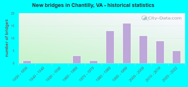
- New bridges - historical statistics
- 11930-1939
- 31960-1969
- 11970-1979
- 131980-1989
- 161990-1999
- 112000-2009
- 92010-2019
- 52020-2022
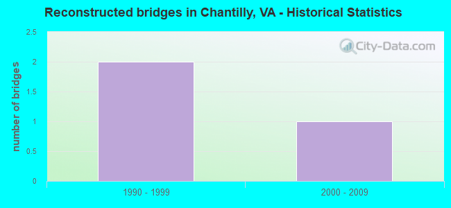
- Reconstructed bridges - Historical Statistics
- 21990-1999
- 12000-2009
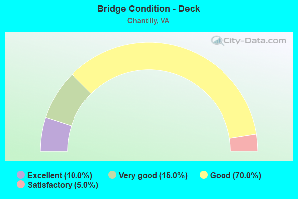
- Bridge Condition - Deck
- 10.0%Excellent
- 15.0%Very good
- 70.0%Good
- 5.0%Satisfactory
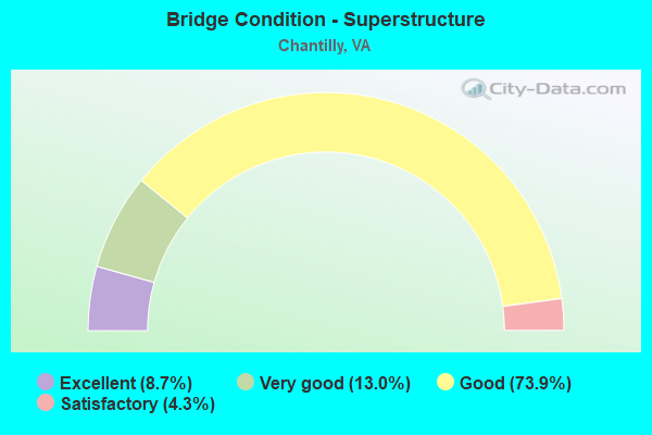
- Bridge Condition - Superstructure
- 8.7%Excellent
- 13.0%Very good
- 73.9%Good
- 4.3%Satisfactory
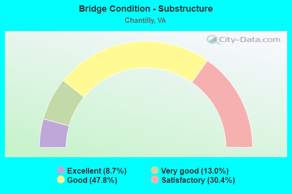
- Bridge Condition - Substructure
- 8.7%Excellent
- 13.0%Very good
- 47.8%Good
- 30.4%Satisfactory
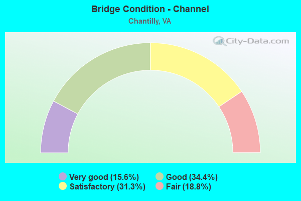
- Bridge Condition - Channel
- 15.6%Very good
- 34.4%Good
- 31.3%Satisfactory
- 18.8%Fair
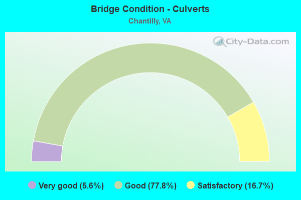
- Bridge Condition - Culverts
- 5.6%Very good
- 77.8%Good
- 16.7%Satisfactory
Find on map >> Show street view
Structure Number: 6256, Location: 03.88FR I-66/03.60TO608 (Lat: 38.897106, Lng: -77.439372), Route carried "under" structure: US 50, Year Built: 1990, Structure Length: 0. m, Average Daily Traffic: 397,070 (year 2003), Truck Traffic: 4%, Features Intersected: Route 50, Facility Carried by Structure: SULLY ROAD
Minimum Vertical Clearance: 5.33m (17.49ft), Kilometerpoint: 0.000, Lanes on structure: 10, Lanes under structure: 4, Material/Design: Steel, Design/Construction: Stringer/Multi-beam, Length of Maximum Span: 37.8m (124.0ft)
Find on map >> Show street view
Structure Number: 6256, Location: 03.88FR I-66/03.60TO608 (Lat: 38.897106, Lng: -77.439372), Route carried "under" structure: US 50, Year Built: 1990, Structure Length: 0. m, Average Daily Traffic: 66,980 (year 2008), Truck Traffic: 4%, Features Intersected: Route 50, Facility Carried by Structure: SULLY ROAD
Minimum Vertical Clearance: 5.24m (17.19ft), Kilometerpoint: 102.542, Lanes on structure: 10, Lanes under structure: 4, Material/Design: Steel, Design/Construction: Stringer/Multi-beam, Length of Maximum Span: 37.8m (124.0ft)
Find on map >> Show street view
Structure Number: 7089, Location: 00.28FR7700/00.35TO66 (Lat: 38.859089, Lng: -77.387350), Route carried "under" structure: County highway 7701, Year Built: 1986, Structure Length: 0. m, Average Daily Traffic: 250 (year 1994), Features Intersected: FAIR LAKES CIRCLE, Facility Carried by Structure: FAIRFAX CO. PKWY.
Minimum Vertical Clearance: 5.16m (16.93ft), Kilometerpoint: 0.000, Lanes on structure: 8, Lanes under structure: 4, Material/Design: Steel, Design/Construction: Stringer/Multi-beam, Length of Maximum Span: 32.9m (107.9ft)
Find on map >> Show street view
Structure Number: 2409, Location: 02.54FR.28/02.16TO50 (Lat: 38.854900, Lng: -77.389019), Route carried "under" structure: State highway 286, Year Built: 1994, Structure Length: 0. m, Average Daily Traffic: 65,728 (year 2008), Truck Traffic: 1%, Features Intersected: FAIRFAX COUNTY PARKWAY, Facility Carried by Structure: ROUTE 66; WB-CD RD
Minimum Vertical Clearance: 5.92m (19.42ft), Kilometerpoint: 0.113, Lanes on structure: 6, Lanes under structure: 4, Material/Design: Steel continuous, Design/Construction: Stringer/Multi-beam, Length of Maximum Span: 31.1m (102.0ft)
Find on map >> Show street view
Structure Number: 2409, Location: 02.54FR.28/02.16TO50 (Lat: 38.854900, Lng: -77.389019), Route carried "under" structure: State highway 286, Year Built: 1994, Structure Length: 0. m, Average Daily Traffic: 65,728 (year 2008), Truck Traffic: 1%, Features Intersected: FAIRFAX COUNTY PARKWAY, Facility Carried by Structure: ROUTE 66; WB-CD RD
Minimum Vertical Clearance: 7.24m (23.75ft), Kilometerpoint: 0.113, Lanes on structure: 6, Lanes under structure: 4, Material/Design: Steel continuous, Design/Construction: Stringer/Multi-beam, Length of Maximum Span: 31.1m (102.0ft)
Find on map >> Show street view
Structure Number: 24366, Location: 01.44FR66/00.45TO750 (Lat: 38.875278, Lng: -77.383397), Route carried "under" structure: US 50, Year Built: 1995, Structure Length: 0. m, Average Daily Traffic: 26,000 (year 1994), Features Intersected: RTE. 50-LEE JACKSON MEM., Facility Carried by Structure: FFX CO. PKWY.NB-SB
Minimum Vertical Clearance: 5.16m (16.93ft), Kilometerpoint: 0.000, Lanes on structure: 6, Lanes under structure: 4, Material/Design: Steel continuous, Design/Construction: Stringer/Multi-beam, Length of Maximum Span: 33.5m (109.9ft)
Find on map >> Show street view
Structure Number: 24366, Location: 01.44FR66/00.45TO750 (Lat: 38.875278, Lng: -77.383397), Route carried "under" structure: US 50, Year Built: 1995, Structure Length: 0. m, Average Daily Traffic: 26,000 (year 1994), Features Intersected: RTE. 50-LEE JACKSON MEM., Facility Carried by Structure: FFX CO. PKWY.NB-SB
Minimum Vertical Clearance: 5.84m (19.16ft), Kilometerpoint: 0.000, Lanes on structure: 6, Lanes under structure: 4, Material/Design: Steel continuous, Design/Construction: Stringer/Multi-beam, Length of Maximum Span: 33.5m (109.9ft)
Find on map >> Show street view
Structure Number: 26731, Location: 00.00FR00000/00.00TO00000 (Lat: 38.915100, Lng: -77.430800), Route carried "under" structure: State highway 28, Year Built: 2003, Structure Length: 0. m, Average Daily Traffic: 29,000 (year 2004), Features Intersected: ROUTE 28 - SULLY ROAD, Facility Carried by Structure: SASM ACCESS ROAD
Minimum Vertical Clearance: 5.23m (17.16ft), Kilometerpoint: 0.000, Lanes on structure: 6, Lanes under structure: 3, Material/Design: Steel continuous, Design/Construction: Stringer/Multi-beam, Length of Maximum Span: 41.8m (137.1ft)
Find on map >> Show street view
Structure Number: 26731, Location: 00.00FR00000/00.00TO00000 (Lat: 38.915100, Lng: -77.430800), Route carried "under" structure: State highway 28, Year Built: 2003, Structure Length: 0. m, Average Daily Traffic: 28,000 (year 2004), Features Intersected: ROUTE 28 - SULLY ROAD, Facility Carried by Structure: SASM ACCESS ROAD
Minimum Vertical Clearance: 5.66m (18.57ft), Kilometerpoint: 0.000, Lanes on structure: 6, Lanes under structure: 4, Material/Design: Steel continuous, Design/Construction: Stringer/Multi-beam, Length of Maximum Span: 41.8m (137.1ft)
Find on map >> Show street view
Structure Number: 26731, Location: 00.00FR00000/00.00TO00000 (Lat: 38.915100, Lng: -77.430800), Route carried "under" structure: Ramp State highway 28, Year Built: 2003, Structure Length: 0. m, Average Daily Traffic: 8,000 (year 2004), Features Intersected: ROUTE 28 - SULLY ROAD, Facility Carried by Structure: SASM ACCESS ROAD
Minimum Vertical Clearance: 5.33m (17.49ft), Kilometerpoint: 0.000, Lanes on structure: 6, Lanes under structure: 2, Material/Design: Steel continuous, Design/Construction: Stringer/Multi-beam, Length of Maximum Span: 41.8m (137.1ft)
Find on map >> Show street view
Structure Number: 26731, Location: 00.00FR00000/00.00TO00000 (Lat: 38.915100, Lng: -77.430800), Route carried "under" structure: Ramp State highway 28, Year Built: 2003, Structure Length: 0. m, Average Daily Traffic: 10,000 (year 2004), Features Intersected: ROUTE 28 - SULLY ROAD, Facility Carried by Structure: SASM ACCESS ROAD
Minimum Vertical Clearance: 5.94m (19.49ft), Kilometerpoint: 0.000, Lanes on structure: 6, Lanes under structure: 2, Material/Design: Steel continuous, Design/Construction: Stringer/Multi-beam, Length of Maximum Span: 41.8m (137.1ft)
Find on map >> Show street view
Structure Number: 28501, Location: 00.60FR657/00.25TO661 (Lat: 38.885850, Lng: -77.447614), Route carried "under" structure: State highway 28, Year Built: 2009, Structure Length: 0. m, Average Daily Traffic: 65,000 (year 2009), Truck Traffic: 1%, Features Intersected: Rte. 28 Sully Rd., Facility Carried by Structure: Willard Rd.
Minimum Vertical Clearance: 5.31m (17.42ft), Kilometerpoint: 0.000, Lanes on structure: 6, Lanes under structure: 3, Material/Design: Steel continuous, Design/Construction: Stringer/Multi-beam, Length of Maximum Span: 30.2m (99.1ft)
Find on map >> Show street view
Structure Number: 28501, Location: 00.60FR657/00.25TO661 (Lat: 38.885850, Lng: -77.447614), Route carried "under" structure: Bypass US 28, Year Built: 2009, Structure Length: 0. m, Average Daily Traffic: 69,000 (year 2009), Truck Traffic: 1%, Features Intersected: Rte. 28 Sully Rd., Facility Carried by Structure: Willard Rd.
Minimum Vertical Clearance: 5.54m (18.18ft), Kilometerpoint: 0.000, Lanes on structure: 6, Lanes under structure: 3, Material/Design: Steel continuous, Design/Construction: Stringer/Multi-beam, Length of Maximum Span: 30.2m (99.1ft)
Find on map >> Show street view
Structure Number: 29443, Location: 0.20 fr 7700 0.70 to 50 (Lat: 38.865156, Lng: -77.381972), Route carried "under" structure: Alternate County highway 7969, Year Built: 2012, Structure Length: 0. m, Average Daily Traffic: 8,000 (year 2012), Truck Traffic: 2%, Features Intersected: Monument Dr., Facility Carried by Structure: Rte 286
Minimum Vertical Clearance: 5.64m (18.50ft), Kilometerpoint: 0.000, Lanes on structure: 6, Lanes under structure: 4, Material/Design: Prestressed concrete, Design/Construction: Stringer/Multi-beam, Length of Maximum Span: 34.1m (111.9ft)
Find on map >> Show street view
Structure Number: 29444, Location: 0.80 fr 66 0.12 to 7969 (Lat: 38.862967, Lng: -77.382133), Route carried "under" structure: Alternate County highway 7700, Year Built: 2010, Structure Length: 0. m, Average Daily Traffic: 15,000 (year 2012), Truck Traffic: 3%, Features Intersected: 7700 Fairlakes Pkwy., Facility Carried by Structure: Rte 286
Minimum Vertical Clearance: 5.74m (18.83ft), Kilometerpoint: 0.000, Lanes on structure: 6, Lanes under structure: 8, Material/Design: Prestressed concrete, Design/Construction: Stringer/Multi-beam, Length of Maximum Span: 42.1m (138.1ft)
Find on map >> Show street view
Structure Number: 30952, Location: .55 FR 28 1.61 TO 50 (Lat: 38.852008, Lng: -77.402967), Route carried "under" structure: County highway 645, Year Built: 2021, Structure Length: 0. m, Features Intersected: STRINGFELLOW RD, Facility Carried by Structure: I-66 WB
Minimum Vertical Clearance: 5.59m (18.34ft), Kilometerpoint: 0.000, Lanes on structure: 6, Lanes under structure: 3, Material/Design: Concrete, Design/Construction: Stringer/Multi-beam, Length of Maximum Span: 35.7m (117.1ft)
Find on map >> Show street view
Structure Number: 30952, Location: .55 FR 28 1.61 TO 50 (Lat: 38.852008, Lng: -77.402967), Route carried "under" structure: County highway 645, Year Built: 2021, Structure Length: 0. m, Features Intersected: STRINGFELLOW RD, Facility Carried by Structure: I-66 WB
Minimum Vertical Clearance: 5.23m (17.16ft), Kilometerpoint: 0.000, Lanes on structure: 6, Lanes under structure: 3, Material/Design: Concrete, Design/Construction: Stringer/Multi-beam, Length of Maximum Span: 35.7m (117.1ft)
Find on map >> Show street view
Structure Number: 31051, Location: 00.40fr66 00.04to620 (Lat: 38.850525, Lng: -77.432961), Route carried "under" structure: Ramp County highway 28, Year Built: 2020, Structure Length: 0. m, Features Intersected: ROUTE 28 NB CD, Facility Carried by Structure: ROUTE 620
Minimum Vertical Clearance: 5.64m (18.50ft), Kilometerpoint: 0.000, Lanes on structure: 2, Lanes under structure: 2, Material/Design: Concrete continuous, Design/Construction: Stringer/Multi-beam, Length of Maximum Span: 38.1m (125.0ft)