Bridge Statistics for Corvallis, Oregon (OR)
Condition, Traffic, Stress, Structural Evaluation, Project Costs
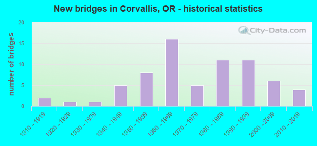
- New bridges - historical statistics
- 21910-1919
- 11920-1929
- 11930-1939
- 51940-1949
- 81950-1959
- 161960-1969
- 51970-1979
- 111980-1989
- 111990-1999
- 62000-2009
- 42010-2019
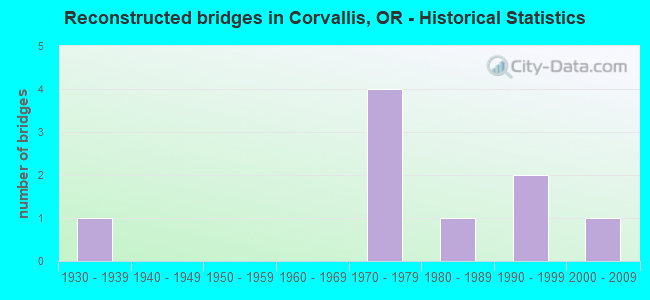
- Reconstructed bridges - Historical Statistics
- 11930-1939
- 01940-1949
- 01950-1959
- 01960-1969
- 41970-1979
- 11980-1989
- 21990-1999
- 12000-2009
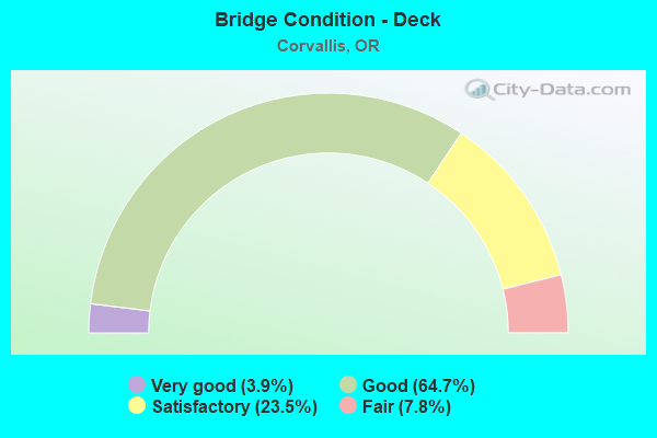
- Bridge Condition - Deck
- 3.9%Very good
- 64.7%Good
- 23.5%Satisfactory
- 7.8%Fair
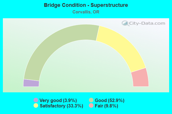
- Bridge Condition - Superstructure
- 3.9%Very good
- 52.9%Good
- 33.3%Satisfactory
- 9.8%Fair
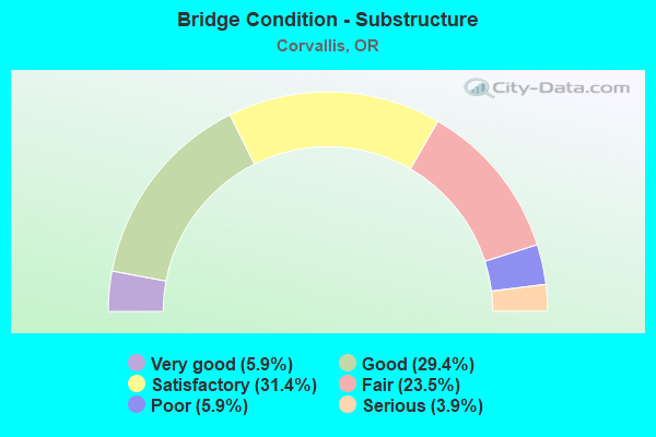
- Bridge Condition - Substructure
- 5.9%Very good
- 29.4%Good
- 31.4%Satisfactory
- 23.5%Fair
- 5.9%Poor
- 3.9%Serious
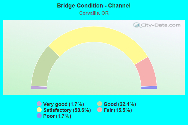
- Bridge Condition - Channel
- 1.7%Very good
- 22.4%Good
- 58.6%Satisfactory
- 15.5%Fair
- 1.7%Poor
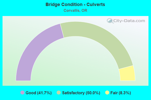
- Bridge Condition - Culverts
- 41.7%Good
- 50.0%Satisfactory
- 8.3%Fair
Find on map >> Show street view
Structure Number: 3C32000000195, Location: 20 NW OF SW 53RD ST-WALNU (Lat: 44.572089, Lng: -123.320011), Route carried "on" structure: County highway , Year Built: 1984, Status: Open, Structure Length: 0.73m (2.40ft), Average Daily Traffic: 1,393 (year 2020), Truck Traffic: 10%, Average Future Daily Traffic: 1,967 (year 2040), Design Load: HS 20, Features Intersected: OAK CREEK, Facility Carried by Structure: NW OAK CREEK DR
Minimum Vertical Clearance: 30+ m (98+ ft), Kilometerpoint: 3.138, Lanes on structure: 2, Owner: County Highway Agency, Approaching Roadway Width: 11.9m (39.0ft), Skew: 3 degrees, Material/Design: Steel, Design/Construction: Culvert, Number Of Spans In Main Unit: 1, Length of Maximum Span: 7.3m (24.0ft), Curb-To-Curb Width: 11.3m (37.1ft), Out-to-Out Width: 11.3m (37.1ft)
Condition: Channel: Satisfactory, Culverts: Satisfactory, Operating Rating: 46.3 metric tons, Method Used To Determine Operating Rating: Load and Resistance Factor Rating (LRFR) rating reported by rating factor(RF) method using HL-93 loadings, Inventory Rating: 35.6 metric tons, Method Used To Determine Inventory Rating: Load and Resistance Factor Rating (LRFR) rating reported by rating factor(RF) method using HL-93 loadings, Structural Evaluation: Equal to present minimum criteria, Deck Geometry: Equal to present minimum criteria, Waterway Adequacy: Equal to present desirable criteria, Approach Roadway Alignment: Equal to present desirable criteria, Designated Inspection Frequency: Every 24 months, Inspection Date: July 2020
Find on map >> Show street view
Structure Number: 420A01W 07997, Location: 004 MI N CORVALLIS (Lat: 44.614061, Lng: -123.244664), Route carried "on" structure: State highway 99, Year Built: 1919, Year Reconstructed: 1942, Status: Open, Structure Length: 0.85m (2.79ft), Average Daily Traffic: 13,294 (year 2020), Truck Traffic: 5%, Average Future Daily Traffic: 17,900 (year 2040), Design Load: H 15, Features Intersected: Jackson Creek
Minimum Vertical Clearance: 30+ m (98+ ft), Kilometerpoint: 128.699, Lanes on structure: 2, Base Highway Network: Yes, Owner: State Highway Agency, Approaching Roadway Width: 11.9m (39.0ft), Material/Design: Concrete continuous, Design/Construction: Slab, Number Of Spans In Main Unit: 2, Length of Maximum Span: 4.3m (14.1ft), Curb-To-Curb Width: 11.6m (38.1ft), Out-to-Out Width: 12.2m (40.0ft)
Condition: Deck: Good, Superstructure: Good, Substructure: Good, Channel: Good, Operating Rating: 28.4 metric tons, Method Used To Determine Operating Rating: Field evaluation and documented engineering judgment, Inventory Rating: 21.9 metric tons, Method Used To Determine Inventory Rating: Field evaluation and documented engineering judgment, Structural Evaluation: Somewhat better than minimum adequacy, Deck Geometry: Somewhat better than minimum adequacy, Waterway Adequacy: Equal to present desirable criteria, Approach Roadway Alignment: Equal to present desirable criteria, Designated Inspection Frequency: Every 24 months, Underwater Inspection Frequency: Every 60 months, Inspection Date: April 2021, Underwater Inspection Date: May 2019, Deck Structure Type: Concrete Cast-file-Place, Wearing Surface/Protective System: Wearing Surface: Bituminous
Find on map >> Show street view
Structure Number: 706 01W 08414, Location: IN CORVALLIS (Lat: 44.556575, Lng: -123.264625), Route carried "on" structure: State highway 99, Year Built: 1933, Year Reconstructed: 1997, Status: Open, Structure Length: 9.38m (30.77ft), Average Daily Traffic: 10,568 (year 2020), Truck Traffic: 4%, Average Future Daily Traffic: 18,000 (year 2040), Design Load: H 15, Features Intersected: Marys River
Minimum Vertical Clearance: 4.50m (14.76ft), Kilometerpoint: 135.410, Lanes on structure: 2, Base Highway Network: Yes, Owner: State Highway Agency, Approaching Roadway Width: 7.3m (24.0ft), Material/Design: Steel, Design/Construction: Truss - Thru, Number Of Spans In Main Unit: 1, Number Of Approach Spans: 7, Length of Maximum Span: 45.7m (149.9ft), Curb or Sidewalk Widths: Left: 2.1m (6.9ft), Right: 2.1m (6.9ft), Curb-To-Curb Width: 7.3m (24.0ft), Out-to-Out Width: 12.3m (40.4ft)
Condition: Deck: Fair, Superstructure: Fair, Substructure: Fair, Channel: Fair, Operating Rating: 22.7 metric tons, Method Used To Determine Operating Rating: Load and Resistance Factor Rating (LRFR) rating reported by rating factor(RF) method using HL-93 loadings, Inventory Rating: 17.5 metric tons, Method Used To Determine Inventory Rating: Load and Resistance Factor Rating (LRFR) rating reported by rating factor(RF) method using HL-93 loadings, Structural Evaluation: Meets minimum limits, Deck Geometry: High priority of replacement, Waterway Adequacy: Equal to present desirable criteria, Approach Roadway Alignment: Equal to present desirable criteria, Length Of Structure Improvement: 9.40m (30.84ft), Designated Inspection Frequency: Every 24 months, Critical Feature Inspection Frequency: Every 24 months, Underwater Inspection Frequency: Every 60 months, Inspection Date: April 2021, Critical Feature Inspection Date: April 2021, Underwater Inspection Date: May 2020, Bridge Improvement Cost: $986,000, Roadway Improvement Cost: $99,000, Total Project Cost: $1,577,000, Deck Structure Type: Concrete Cast-file-Place, Wearing Surface/Protective System: Wearing Surface: Epoxy Overlay
Find on map >> Show street view
Structure Number: 2701A01W 08476, Location: 1/2 MI S OF MARY'S RV (Lat: 44.547964, Lng: -123.265583), Route carried "on" structure: State highway 99, Year Built: 1992, Status: Open, Structure Length: 2.13m (6.99ft), Average Daily Traffic: 19,152 (year 2020), Truck Traffic: 5%, Average Future Daily Traffic: 35,100 (year 2040), Design Load: HS 25 or greater, Features Intersected: Creek
Minimum Vertical Clearance: 30+ m (98+ ft), Kilometerpoint: 136.408, Lanes on structure: 4, Base Highway Network: Yes, Owner: State Highway Agency, Approaching Roadway Width: 22.6m (74.1ft), Skew: 3 degrees, Material/Design: Prestressed concrete, Design/Construction: Slab, Number Of Spans In Main Unit: 1, Length of Maximum Span: 21.3m (69.9ft), Curb or Sidewalk Widths: Left: 1.7m (5.6ft), Right: 1.7m (5.6ft), Curb-To-Curb Width: 22.6m (74.1ft), Out-to-Out Width: 26.8m (87.9ft)
Condition: Deck: Good, Superstructure: Good, Substructure: Good, Channel: Very good, Operating Rating: 39.5 metric tons, Method Used To Determine Operating Rating: Load and Resistance Factor Rating (LRFR) rating reported by rating factor(RF) method using HL-93 loadings, Inventory Rating: 30.5 metric tons, Method Used To Determine Inventory Rating: Load and Resistance Factor Rating (LRFR) rating reported by rating factor(RF) method using HL-93 loadings, Structural Evaluation: Better than present minimum criteria, Deck Geometry: Superior to present desirable criteria, Waterway Adequacy: Equal to present desirable criteria, Approach Roadway Alignment: Equal to present desirable criteria, Designated Inspection Frequency: Every 24 months, Inspection Date: April 2021, Deck Structure Type: Concrete Precast Panels, Wearing Surface/Protective System: Wearing Surface: Bituminous, Membrane: Preformed Fabric, Deck Protection: Epoxy Coated Reinforcing
Find on map >> Show street view
Structure Number: 2728 210 00013, Location: 001 E HWY 31 & 210 JCT (Lat: 44.565431, Lng: -123.256533), Route carried "on" structure: State highway 34, Year Built: 1913, Year Reconstructed: 1998, Status: Posted for load, Structure Length: 21.74m (71.33ft), Average Daily Traffic: 9,913 (year 2020), Truck Traffic: 7%, Average Future Daily Traffic: 13,400 (year 2040), Design Load: H 15, Features Intersected: Willamette River, Facility Carried by Structure: HWY 210 EB
Minimum Vertical Clearance: 5.18m (16.99ft), Kilometerpoint: 0.209, Lanes on structure: 1, Base Highway Network: Yes, Owner: State Highway Agency, Approaching Roadway Width: 6.4m (21.0ft), Navigation Control: Yes ( Vertical Clearance: 10.7m (35.1ft), Horizontal Clearance: 31.1m (102.0ft)), Material/Design: Steel, Design/Construction: Truss - Thru, Number Of Spans In Main Unit: 4, Number Of Approach Spans: 12, Length of Maximum Span: 52.7m (172.9ft), Curb or Sidewalk Widths: Left: 0.0m, Right: 1.5m (4.9ft), Curb-To-Curb Width: 5.3m (17.4ft), Out-to-Out Width: 7.9m (25.9ft)
Condition: Deck: Satisfactory, Superstructure: Fair, Substructure: Poor, Channel: Satisfactory, Operating Rating: 7.1 metric tons, Method Used To Determine Operating Rating: Load and Resistance Factor Rating (LRFR) rating reported by rating factor(RF) method using HL-93 loadings, Inventory Rating: 5.5 metric tons, Method Used To Determine Inventory Rating: Load and Resistance Factor Rating (LRFR) rating reported by rating factor(RF) method using HL-93 loadings, Structural Evaluation: High priority of corrective action, Deck Geometry: High priority of replacement, Waterway Adequacy: Equal to present desirable criteria, Approach Roadway Alignment: Equal to present desirable criteria, Bridge Posting: Required (Relationship of Operating Rating to Maximum Legal Load: > 39.9% below), Length Of Structure Improvement: 21.70m (71.19ft), Designated Inspection Frequency: Every 12 months, Critical Feature Inspection Frequency: Every 24 months, Underwater Inspection Frequency: Every 24 months, Inspection Date: June 2021, Critical Feature Inspection Date: June 2020, Underwater Inspection Date: September 2021, Bridge Improvement Cost: $2,284,000, Roadway Improvement Cost: $228,000, Total Project Cost: $3,655,000, Deck Structure Type: Wood or Timber, Wearing Surface/Protective System: Wearing Surface: Bituminous, Membrane: Preformed Fabric
Find on map >> Show street view
Structure Number: 3C04, Location: 001 MILE W OF NW 23RD ST (Lat: 44.587761, Lng: -123.279950), Route carried "on" structure: City street , Year Built: 1987, Status: Open, Structure Length: 0.76m (2.49ft), Average Daily Traffic: 563 (year 2020), Truck Traffic: 10%, Average Future Daily Traffic: 984 (year 2040), Design Load: HS 25 or greater, Features Intersected: DIXON CREEK, Facility Carried by Structure: NW ELMWOOD DRIVE
Minimum Vertical Clearance: 30+ m (98+ ft), Kilometerpoint: 0.000, Lanes on structure: 2, Owner: City or Municipal Highway Agency, Approaching Roadway Width: 10.4m (34.1ft), Skew: 3 degrees, Material/Design: Prestressed concrete, Design/Construction: Slab, Number Of Spans In Main Unit: 1, Length of Maximum Span: 7.3m (24.0ft), Curb or Sidewalk Widths: Left: 1.8m (5.9ft), Right: 1.8m (5.9ft), Curb-To-Curb Width: 10.4m (34.1ft), Out-to-Out Width: 14.6m (47.9ft)
Condition: Deck: Good, Superstructure: Good, Substructure: Good, Channel: Satisfactory, Operating Rating: 82.6 metric tons, Method Used To Determine Operating Rating: Load Factor (LF), Inventory Rating: 49.9 metric tons, Method Used To Determine Inventory Rating: Load Factor (LF), Structural Evaluation: Better than present minimum criteria, Deck Geometry: Equal to present minimum criteria, Waterway Adequacy: Equal to present desirable criteria, Approach Roadway Alignment: Equal to present desirable criteria, Designated Inspection Frequency: Every 24 months, Inspection Date: July 2020, Deck Structure Type: Other, Wearing Surface/Protective System: Wearing Surface: Bituminous
Find on map >> Show street view
Structure Number: 3C08, Location: 00.1 MI W OF NW 17TH ST (Lat: 44.583000, Lng: -123.272589), Route carried "on" structure: City street , Year Built: 1958, Status: Open, Structure Length: 1.13m (3.71ft), Average Daily Traffic: 3,374 (year 2020), Truck Traffic: 5%, Average Future Daily Traffic: 5,463 (year 2040), Design Load: H 15, Features Intersected: DIXON CR, Facility Carried by Structure: NW GARFIELD AVE
Minimum Vertical Clearance: 30+ m (98+ ft), Kilometerpoint: 1.287, Lanes on structure: 2, Owner: City or Municipal Highway Agency, Approaching Roadway Width: 12.2m (40.0ft), Material/Design: Wood or Timber, Design/Construction: Slab, Number Of Spans In Main Unit: 1, Number Of Approach Spans: 2, Length of Maximum Span: 7.0m (23.0ft), Curb or Sidewalk Widths: Left: 1.7m (5.6ft), Right: 1.7m (5.6ft), Curb-To-Curb Width: 12.1m (39.7ft), Out-to-Out Width: 16.8m (55.1ft)
Condition: Deck: Fair, Superstructure: Fair, Substructure: Fair, Channel: Satisfactory, Operating Rating: 39.9 metric tons, Method Used To Determine Operating Rating: Allowable Stress (AS), Inventory Rating: 24.5 metric tons, Method Used To Determine Inventory Rating: Allowable Stress (AS), Structural Evaluation: Somewhat better than minimum adequacy, Deck Geometry: Somewhat better than minimum adequacy, Waterway Adequacy: Equal to present desirable criteria, Approach Roadway Alignment: Equal to present desirable criteria, Designated Inspection Frequency: Every 24 months, Inspection Date: July 2020, Deck Structure Type: Wood or Timber, Wearing Surface/Protective System: Wearing Surface: Bituminous
Find on map >> Show street view
Structure Number: 3C11A, Location: AT 16TH STREET (Lat: 44.578169, Lng: -123.269911), Route carried "on" structure: City street , Year Built: 1984, Status: Open, Structure Length: 0.88m (2.89ft), Average Daily Traffic: 1,769 (year 2020), Truck Traffic: 10%, Average Future Daily Traffic: 3,713 (year 2040), Design Load: HS 20, Features Intersected: DIXON CR, Facility Carried by Structure: NW BECA AVE
Minimum Vertical Clearance: 30+ m (98+ ft), Kilometerpoint: 0.000, Lanes on structure: 2, Owner: City or Municipal Highway Agency, Approaching Roadway Width: 12.2m (40.0ft), Skew: 1 degrees, Material/Design: Prestressed concrete, Design/Construction: Slab, Number Of Spans In Main Unit: 1, Length of Maximum Span: 8.8m (28.9ft), Curb or Sidewalk Widths: Left: 1.5m (4.9ft), Right: 1.5m (4.9ft), Curb-To-Curb Width: 12.2m (40.0ft), Out-to-Out Width: 15.8m (51.8ft)
Condition: Deck: Good, Superstructure: Satisfactory, Substructure: Satisfactory, Channel: Satisfactory, Operating Rating: 59.0 metric tons, Method Used To Determine Operating Rating: Load Factor (LF), Inventory Rating: 35.4 metric tons, Method Used To Determine Inventory Rating: Load Factor (LF), Structural Evaluation: Equal to present minimum criteria, Deck Geometry: Better than present minimum criteria, Waterway Adequacy: Equal to present desirable criteria, Approach Roadway Alignment: Equal to present desirable criteria, Designated Inspection Frequency: Every 24 months, Inspection Date: July 2020, Deck Structure Type: Other, Wearing Surface/Protective System: Wearing Surface: Bituminous
Find on map >> Show street view
Structure Number: 3C13A, Location: .2 MI S OF BUCHANAN AVE (Lat: 44.575161, Lng: -123.265100), Route carried "on" structure: City street , Year Built: 1981, Status: Open, Structure Length: 0.85m (2.79ft), Average Daily Traffic: 2,393 (year 2020), Truck Traffic: 10%, Average Future Daily Traffic: 3,448 (year 2040), Design Load: HS 20, Features Intersected: DIXON CR, Facility Carried by Structure: NW 11TH ST
Minimum Vertical Clearance: 30+ m (98+ ft), Kilometerpoint: 0.000, Lanes on structure: 2, Owner: City or Municipal Highway Agency, Approaching Roadway Width: 12.2m (40.0ft), Material/Design: Prestressed concrete, Design/Construction: Slab, Number Of Spans In Main Unit: 1, Length of Maximum Span: 8.5m (27.9ft), Curb or Sidewalk Widths: Left: 1.8m (5.9ft), Right: 1.8m (5.9ft), Curb-To-Curb Width: 12.2m (40.0ft), Out-to-Out Width: 16.2m (53.1ft)
Condition: Deck: Good, Superstructure: Good, Substructure: Satisfactory, Channel: Good, Operating Rating: 58.1 metric tons, Method Used To Determine Operating Rating: Load Factor (LF), Inventory Rating: 34.5 metric tons, Method Used To Determine Inventory Rating: Load Factor (LF), Structural Evaluation: Equal to present minimum criteria, Deck Geometry: Equal to present minimum criteria, Waterway Adequacy: Equal to present desirable criteria, Approach Roadway Alignment: Equal to present desirable criteria, Designated Inspection Frequency: Every 24 months, Inspection Date: July 2020, Deck Structure Type: Other, Wearing Surface/Protective System: Wearing Surface: Bituminous
Find on map >> Show street view
Structure Number: 3C14A, Location: .2 MI S OF BUCHANAN AVE (Lat: 44.574811, Lng: -123.264069), Route carried "on" structure: City street , Year Built: 1984, Status: Open, Structure Length: 0.88m (2.89ft), Average Daily Traffic: 2,393 (year 2020), Truck Traffic: 5%, Average Future Daily Traffic: 3,501 (year 2040), Design Load: HS 20, Features Intersected: DIXON CR, Facility Carried by Structure: NW 10TH ST
Minimum Vertical Clearance: 30+ m (98+ ft), Kilometerpoint: 0.000, Lanes on structure: 2, Owner: City or Municipal Highway Agency, Approaching Roadway Width: 10.4m (34.1ft), Material/Design: Prestressed concrete, Design/Construction: Slab, Number Of Spans In Main Unit: 1, Length of Maximum Span: 8.5m (27.9ft), Curb or Sidewalk Widths: Left: 1.5m (4.9ft), Right: 1.5m (4.9ft), Curb-To-Curb Width: 10.4m (34.1ft), Out-to-Out Width: 14.0m (45.9ft)
Condition: Deck: Satisfactory, Superstructure: Satisfactory, Substructure: Satisfactory, Channel: Satisfactory, Operating Rating: 89.7 metric tons, Method Used To Determine Operating Rating: Load and Resistance Factor Rating (LRFR) rating reported by rating factor(RF) method using HL-93 loadings, Inventory Rating: 69.0 metric tons, Method Used To Determine Inventory Rating: Load and Resistance Factor Rating (LRFR) rating reported by rating factor(RF) method using HL-93 loadings, Structural Evaluation: Equal to present minimum criteria, Deck Geometry: Somewhat better than minimum adequacy, Waterway Adequacy: Equal to present desirable criteria, Approach Roadway Alignment: Equal to present desirable criteria, Designated Inspection Frequency: Every 24 months, Inspection Date: July 2020, Deck Structure Type: Other, Wearing Surface/Protective System: Wearing Surface: Bituminous
Find on map >> Show street view
Structure Number: 3C155000000004, Location: 0.4 MILES W OF 53RD ST (Lat: 44.588389, Lng: -123.337681), Route carried "on" structure: County highway , Year Built: 1984, Status: Open, Structure Length: 0.70m (2.30ft), Average Daily Traffic: 2,893 (year 2020), Truck Traffic: 10%, Average Future Daily Traffic: 3,939 (year 2040), Design Load: HS 20, Features Intersected: OAK CREEK, Facility Carried by Structure: NW OAK CREEK DR
Minimum Vertical Clearance: 30+ m (98+ ft), Kilometerpoint: 0.644, Lanes on structure: 2, Owner: County Highway Agency, Approaching Roadway Width: 11.9m (39.0ft), Skew: 4 degrees, Material/Design: Steel, Design/Construction: Culvert, Number Of Spans In Main Unit: 1, Length of Maximum Span: 7.0m (23.0ft), Curb-To-Curb Width: 11.9m (39.0ft), Out-to-Out Width: 11.9m (39.0ft)
Condition: Channel: Satisfactory, Culverts: Satisfactory, Operating Rating: 59.3 metric tons, Method Used To Determine Operating Rating: Load and Resistance Factor Rating (LRFR) rating reported by rating factor(RF) method using HL-93 loadings, Inventory Rating: 45.7 metric tons, Method Used To Determine Inventory Rating: Load and Resistance Factor Rating (LRFR) rating reported by rating factor(RF) method using HL-93 loadings, Structural Evaluation: Equal to present minimum criteria, Deck Geometry: Somewhat better than minimum adequacy, Waterway Adequacy: Equal to present desirable criteria, Approach Roadway Alignment: Equal to present minimum criteria, Designated Inspection Frequency: Every 24 months, Inspection Date: July 2020
Find on map >> Show street view
Structure Number: 3C18, Location: BETWEEN NW 3RD AND 4TH ST (Lat: 44.572981, Lng: -123.257369), Route carried "on" structure: City street , Year Built: 1972, Status: Open, Structure Length: 0.76m (2.49ft), Average Daily Traffic: 4,785 (year 2020), Truck Traffic: 10%, Average Future Daily Traffic: 6,790 (year 2040), Design Load: HS 20, Features Intersected: DIXON CR, Facility Carried by Structure: NW BUCHANAN AVE
Minimum Vertical Clearance: 30+ m (98+ ft), Kilometerpoint: 0.000, Lanes on structure: 2, Owner: City or Municipal Highway Agency, Approaching Roadway Width: 12.4m (40.7ft), Skew: 4 degrees, Material/Design: Concrete continuous, Design/Construction: Culvert, Number Of Spans In Main Unit: 2, Length of Maximum Span: 3.4m (11.2ft), Curb-To-Curb Width: 12.4m (40.7ft), Out-to-Out Width: 12.4m (40.7ft)
Condition: Channel: Satisfactory, Culverts: Satisfactory, Operating Rating: 46.3 metric tons, Method Used To Determine Operating Rating: Load and Resistance Factor Rating (LRFR) rating reported by rating factor(RF) method using HL-93 loadings, Inventory Rating: 35.6 metric tons, Method Used To Determine Inventory Rating: Load and Resistance Factor Rating (LRFR) rating reported by rating factor(RF) method using HL-93 loadings, Structural Evaluation: Equal to present minimum criteria, Deck Geometry: Equal to present minimum criteria, Waterway Adequacy: Equal to present desirable criteria, Approach Roadway Alignment: Equal to present desirable criteria, Designated Inspection Frequency: Every 24 months, Inspection Date: July 2020, Deck Structure Type: Concrete Cast-file-Place
Find on map >> Show street view
Structure Number: 3C26, Location: 0.20 S.OF HWY 20/34 (Lat: 44.552750, Lng: -123.279600), Route carried "on" structure: City street , Year Built: 1987, Status: Open, Structure Length: 1.25m (4.10ft), Average Daily Traffic: 1,795 (year 2020), Truck Traffic: 10%, Average Future Daily Traffic: 2,546 (year 2040), Design Load: HS 25 or greater, Features Intersected: DUNAWI CREEK, Facility Carried by Structure: SW BROOKLANE DR.
Minimum Vertical Clearance: 30+ m (98+ ft), Kilometerpoint: 0.322, Lanes on structure: 2, Owner: City or Municipal Highway Agency, Approaching Roadway Width: 11.0m (36.1ft), Material/Design: Prestressed concrete, Design/Construction: Slab, Number Of Spans In Main Unit: 1, Length of Maximum Span: 12.2m (40.0ft), Curb or Sidewalk Widths: Left: 1.5m (4.9ft), Right: 1.5m (4.9ft), Curb-To-Curb Width: 11.0m (36.1ft), Out-to-Out Width: 14.6m (47.9ft)
Condition: Deck: Good, Superstructure: Good, Substructure: Good, Channel: Good, Operating Rating: 89.7 metric tons, Method Used To Determine Operating Rating: Load and Resistance Factor Rating (LRFR) rating reported by rating factor(RF) method using HL-93 loadings, Inventory Rating: 69.0 metric tons, Method Used To Determine Inventory Rating: Load and Resistance Factor Rating (LRFR) rating reported by rating factor(RF) method using HL-93 loadings, Structural Evaluation: Better than present minimum criteria, Deck Geometry: Equal to present minimum criteria, Waterway Adequacy: Equal to present desirable criteria, Approach Roadway Alignment: Equal to present desirable criteria, Designated Inspection Frequency: Every 24 months, Inspection Date: July 2020, Deck Structure Type: Other, Wearing Surface/Protective System: Wearing Surface: Bituminous
Find on map >> Show street view
Structure Number: 3C27, Location: E OF HWY 99W (Lat: 44.549856, Lng: -123.264642), Route carried "on" structure: City street , Year Built: 1965, Status: Posted for load, Structure Length: 1.37m (4.49ft), Average Daily Traffic: 1,114 (year 2021), Truck Traffic: 5%, Average Future Daily Traffic: 1,697 (year 2041), Features Intersected: MILL RACE, Facility Carried by Structure: SE BRIDGEWAY AVE
Minimum Vertical Clearance: 30+ m (98+ ft), Kilometerpoint: 0.080, Lanes on structure: 2, Owner: City or Municipal Highway Agency, Approaching Roadway Width: 7.3m (24.0ft), Skew: 2 degrees, Material/Design: Wood or Timber, Design/Construction: Slab, Number Of Spans In Main Unit: 2, Length of Maximum Span: 6.7m (22.0ft), Curb or Sidewalk Widths: Left: 0.0m, Right: 1.4m (4.6ft), Curb-To-Curb Width: 8.1m (26.6ft), Out-to-Out Width: 10.1m (33.1ft)
Condition: Deck: Good, Superstructure: Satisfactory, Substructure: Fair, Channel: Satisfactory, Operating Rating: 31.8 metric tons, Method Used To Determine Operating Rating: Allowable Stress (AS), Inventory Rating: 22.7 metric tons, Method Used To Determine Inventory Rating: Allowable Stress (AS), Structural Evaluation: Somewhat better than minimum adequacy, Deck Geometry: Meets minimum limits, Waterway Adequacy: Equal to present desirable criteria, Approach Roadway Alignment: Equal to present desirable criteria, Bridge Posting: Required (Relationship of Operating Rating to Maximum Legal Load: 20.0 - 29.9% below), Designated Inspection Frequency: Every 12 months, Inspection Date: July 2021, Deck Structure Type: Wood or Timber, Wearing Surface/Protective System: Wearing Surface: Bituminous
Find on map >> Show street view
Structure Number: 4267A210 00245, Location: 2.45 MI E CORVALLIS (Lat: 44.564075, Lng: -123.209636), Route carried "on" structure: State highway 34, Year Built: 1965, Status: Open, Structure Length: 3.66m (12.01ft), Average Daily Traffic: 27,056 (year 2020), Truck Traffic: 7%, Average Future Daily Traffic: 39,300 (year 2040), Design Load: HS 20, Features Intersected: Owl Creek
Minimum Vertical Clearance: 30+ m (98+ ft), Kilometerpoint: 3.943, Lanes on structure: 4, Base Highway Network: Yes, Owner: State Highway Agency, Approaching Roadway Width: 21.9m (71.9ft), Material/Design: Prestressed concrete, Design/Construction: Slab, Number Of Spans In Main Unit: 4, Length of Maximum Span: 9.1m (29.9ft), Curb-To-Curb Width: 21.9m (71.9ft), Out-to-Out Width: 22.5m (73.8ft)
Condition: Deck: Satisfactory, Superstructure: Satisfactory, Substructure: Satisfactory, Channel: Good, Operating Rating: 70.6 metric tons, Method Used To Determine Operating Rating: Load and Resistance Factor Rating (LRFR) rating reported by rating factor(RF) method using HL-93 loadings, Inventory Rating: 54.4 metric tons, Method Used To Determine Inventory Rating: Load and Resistance Factor Rating (LRFR) rating reported by rating factor(RF) method using HL-93 loadings, Structural Evaluation: Equal to present minimum criteria, Deck Geometry: Superior to present desirable criteria, Waterway Adequacy: Equal to present desirable criteria, Approach Roadway Alignment: Equal to present desirable criteria, Designated Inspection Frequency: Every 24 months, Inspection Date: October 2020, Deck Structure Type: Concrete Precast Panels, Wearing Surface/Protective System: Wearing Surface: Bituminous
Find on map >> Show street view
Structure Number: 7019 01W 08421, Location: IN CORVALLIS (Lat: 44.555839, Lng: -123.265667), Route carried "on" structure: State highway 99, Year Built: 1949, Year Reconstructed: 1992, Status: Open, Structure Length: 12.37m (40.58ft), Average Daily Traffic: 22,595 (year 2020), Truck Traffic: 5%, Average Future Daily Traffic: 38,600 (year 2040), Design Load: HS 15, Features Intersected: Marys River
Minimum Vertical Clearance: 30+ m (98+ ft), Kilometerpoint: 135.523, Lanes on structure: 3, Lanes under structure: 1, Base Highway Network: Yes, Owner: State Highway Agency, Approaching Roadway Width: 13.1m (43.0ft), Material/Design: Concrete continuous, Design/Construction: Tee Beam, Number Of Spans In Main Unit: 8, Length of Maximum Span: 21.3m (69.9ft), Curb or Sidewalk Widths: Left: 0.0m, Right: 1.5m (4.9ft), Curb-To-Curb Width: 13.1m (43.0ft), Out-to-Out Width: 15.3m (50.2ft)
Condition: Deck: Satisfactory, Superstructure: Satisfactory, Substructure: Fair, Channel: Satisfactory, Operating Rating: 39.9 metric tons, Method Used To Determine Operating Rating: Load Factor (LF), Inventory Rating: 24.5 metric tons, Method Used To Determine Inventory Rating: Load Factor (LF), Structural Evaluation: Somewhat better than minimum adequacy, Deck Geometry: Meets minimum limits, Underclear: High priority of corrective action, Waterway Adequacy: Equal to present desirable criteria, Approach Roadway Alignment: Equal to present desirable criteria, Length Of Structure Improvement: 12.40m (40.68ft), Designated Inspection Frequency: Every 24 months, Underwater Inspection Frequency: Every 36 months, Inspection Date: April 2021, Underwater Inspection Date: May 2021, Bridge Improvement Cost: $1,300,000, Roadway Improvement Cost: $130,000, Total Project Cost: $2,080,000, Deck Structure Type: Concrete Cast-file-Place, Wearing Surface/Protective System: Wearing Surface: Epoxy Overlay, Deck Protection: Epoxy Coated Reinforcing
Find on map >> Show street view
Structure Number: 7321 01W 08261, Location: 007 MI S CORVALLIS (Lat: 44.577494, Lng: -123.257911), Route carried "on" structure: State highway 99, Year Built: 1954, Status: Open, Structure Length: 7.64m (25.07ft), Average Daily Traffic: 9,160 (year 2020), Truck Traffic: 3%, Average Future Daily Traffic: 11,800 (year 2040), Design Load: HS 20, Features Intersected: WPRR
Minimum Vertical Clearance: 30+ m (98+ ft), Kilometerpoint: 132.948, Lanes on structure: 4, Lanes under structure: 2, Base Highway Network: Yes, Owner: State Highway Agency, Approaching Roadway Width: 17.7m (58.1ft), Skew: 4 degrees, Material/Design: Concrete continuous, Design/Construction: Tee Beam, Number Of Spans In Main Unit: 4, Length of Maximum Span: 24.8m (81.4ft), Curb or Sidewalk Widths: Left: 1.1m (3.6ft), Right: 1.1m (3.6ft), Curb-To-Curb Width: 17.7m (58.1ft), Out-to-Out Width: 20.5m (67.3ft)
Condition: Deck: Fair, Superstructure: Fair, Substructure: Satisfactory, Operating Rating: 22.7 metric tons, Method Used To Determine Operating Rating: Load and Resistance Factor Rating (LRFR) rating reported by rating factor(RF) method using HL-93 loadings, Inventory Rating: 17.5 metric tons, Method Used To Determine Inventory Rating: Load and Resistance Factor Rating (LRFR) rating reported by rating factor(RF) method using HL-93 loadings, Structural Evaluation: Meets minimum limits, Deck Geometry: Somewhat better than minimum adequacy, Underclear: Equal to present minimum criteria, Approach Roadway Alignment: Equal to present desirable criteria, Designated Inspection Frequency: Every 24 months, Inspection Date: April 2021, Deck Structure Type: Concrete Cast-file-Place, Wearing Surface/Protective System: Wearing Surface: Epoxy Overlay
Find on map >> Show street view
Structure Number: 7T05 000000265, Location: W OF NW 23RD (Lat: 44.586369, Lng: -123.278681), Route carried "on" structure: City street , Year Built: 1996, Status: Posted for load, Structure Length: 0.79m (2.59ft), Average Daily Traffic: 8,322 (year 2020), Truck Traffic: 10%, Average Future Daily Traffic: 12,200 (year 2040), Design Load: HS 25 or greater, Features Intersected: DIXON CREEK, Facility Carried by Structure: NW CIRCLE BLVD.
Minimum Vertical Clearance: 30+ m (98+ ft), Kilometerpoint: 4.265, Lanes on structure: 4, Owner: City or Municipal Highway Agency, Approaching Roadway Width: 18.3m (60.0ft), Material/Design: Concrete continuous, Design/Construction: Culvert, Number Of Spans In Main Unit: 2, Length of Maximum Span: 3.7m (12.1ft), Curb or Sidewalk Widths: Left: 1.7m (5.6ft), Right: 1.7m (5.6ft), Curb-To-Curb Width: 18.4m (60.4ft), Out-to-Out Width: 21.9m (71.9ft)
Condition: Channel: Satisfactory, Culverts: Satisfactory, Operating Rating: 25.2 metric tons, Method Used To Determine Operating Rating: Field evaluation and documented engineering judgment, Inventory Rating: 19.5 metric tons, Method Used To Determine Inventory Rating: Field evaluation and documented engineering judgment, Structural Evaluation: Meets minimum limits, Deck Geometry: Somewhat better than minimum adequacy, Waterway Adequacy: Equal to present desirable criteria, Approach Roadway Alignment: Equal to present desirable criteria, Bridge Posting: Required (Relationship of Operating Rating to Maximum Legal Load: 0.1 - 9.9% below), Designated Inspection Frequency: Every 24 months, Inspection Date: July 2020, Wearing Surface/Protective System: Wearing Surface: Bituminous
Find on map >> Show street view
Structure Number: 7T06, Location: 0.08 ML SO OF CIRCLE BLVD (Lat: 44.585350, Lng: -123.276000), Route carried "on" structure: City street , Year Built: 1991, Status: Open, Structure Length: 0.67m (2.20ft), Average Daily Traffic: 15,709 (year 2020), Truck Traffic: 10%, Average Future Daily Traffic: 22,279 (year 2040), Design Load: HS 25 or greater, Features Intersected: DIXON CREEK, Facility Carried by Structure: KINGS BLVD
Minimum Vertical Clearance: 30+ m (98+ ft), Kilometerpoint: 0.000, Lanes on structure: 2, Owner: City or Municipal Highway Agency, Approaching Roadway Width: 13.4m (44.0ft), Material/Design: Concrete continuous, Design/Construction: Culvert, Number Of Spans In Main Unit: 2, Length of Maximum Span: 3.0m (9.8ft), Curb or Sidewalk Widths: Left: 2.8m (9.2ft), Right: 3.0m (9.8ft), Curb-To-Curb Width: 14.8m (48.6ft), Out-to-Out Width: 20.6m (67.6ft)
Condition: Channel: Satisfactory, Culverts: Satisfactory, Operating Rating: 37.9 metric tons, Method Used To Determine Operating Rating: Load and Resistance Factor Rating (LRFR) rating reported by rating factor(RF) method using HL-93 loadings, Inventory Rating: 29.2 metric tons, Method Used To Determine Inventory Rating: Load and Resistance Factor Rating (LRFR) rating reported by rating factor(RF) method using HL-93 loadings, Structural Evaluation: Equal to present minimum criteria, Deck Geometry: Superior to present desirable criteria, Waterway Adequacy: Equal to present desirable criteria, Approach Roadway Alignment: Equal to present desirable criteria, Designated Inspection Frequency: Every 24 months, Inspection Date: July 2020, Wearing Surface/Protective System: Wearing Surface: Bituminous
Find on map >> Show street view
Structure Number: 7T10 000 0003, Location: E OF NW 17TH ST (Lat: 44.579569, Lng: -123.269811), Route carried "on" structure: City street , Year Built: 1967, Status: Open, Structure Length: 0.73m (2.40ft), Average Daily Traffic: 4,525 (year 2020), Truck Traffic: 10%, Average Future Daily Traffic: 5,517 (year 2040), Design Load: H 20, Features Intersected: DIXON CR, Facility Carried by Structure: NW GRANT ST
Minimum Vertical Clearance: 30+ m (98+ ft), Kilometerpoint: 0.483, Lanes on structure: 2, Owner: City or Municipal Highway Agency, Approaching Roadway Width: 12.2m (40.0ft), Material/Design: Prestressed concrete, Design/Construction: Slab, Number Of Spans In Main Unit: 1, Length of Maximum Span: 7.0m (23.0ft), Curb or Sidewalk Widths: Left: 1.2m (3.9ft), Right: 1.2m (3.9ft), Curb-To-Curb Width: 12.2m (40.0ft), Out-to-Out Width: 14.8m (48.6ft)
Condition: Deck: Good, Superstructure: Good, Substructure: Fair, Channel: Fair, Operating Rating: 59.0 metric tons, Method Used To Determine Operating Rating: Load Factor (LF), Inventory Rating: 36.3 metric tons, Method Used To Determine Inventory Rating: Load Factor (LF), Structural Evaluation: Somewhat better than minimum adequacy, Deck Geometry: Equal to present minimum criteria, Waterway Adequacy: Better than present minimum criteria, Approach Roadway Alignment: Equal to present desirable criteria, Designated Inspection Frequency: Every 24 months, Inspection Date: July 2020, Deck Structure Type: Other, Wearing Surface/Protective System: Wearing Surface: Bituminous
Find on map >> Show street view
Structure Number: 7T12A, Location: W OF NW 13TH ST (Lat: 44.576100, Lng: -123.267589), Route carried "on" structure: City street , Year Built: 1981, Status: Open, Structure Length: 1.19m (3.90ft), Average Daily Traffic: 7,698 (year 2020), Truck Traffic: 10%, Average Future Daily Traffic: 9,548 (year 2040), Design Load: HS 20, Features Intersected: DIXON CREEK, Facility Carried by Structure: NW BUCHANAN AVE
Minimum Vertical Clearance: 30+ m (98+ ft), Kilometerpoint: 0.000, Lanes on structure: 2, Owner: City or Municipal Highway Agency, Approaching Roadway Width: 12.2m (40.0ft), Skew: 3 degrees, Material/Design: Prestressed concrete, Design/Construction: Slab, Number Of Spans In Main Unit: 1, Length of Maximum Span: 11.0m (36.1ft), Curb or Sidewalk Widths: Left: 1.8m (5.9ft), Right: 1.8m (5.9ft), Curb-To-Curb Width: 12.2m (40.0ft), Out-to-Out Width: 16.6m (54.5ft)
Condition: Deck: Good, Superstructure: Good, Substructure: Satisfactory, Channel: Satisfactory, Operating Rating: 57.2 metric tons, Method Used To Determine Operating Rating: Load Factor (LF), Inventory Rating: 34.5 metric tons, Method Used To Determine Inventory Rating: Load Factor (LF), Structural Evaluation: Equal to present minimum criteria, Deck Geometry: Somewhat better than minimum adequacy, Waterway Adequacy: Equal to present desirable criteria, Approach Roadway Alignment: Equal to present desirable criteria, Designated Inspection Frequency: Every 24 months, Inspection Date: July 2020, Deck Structure Type: Other, Wearing Surface/Protective System: Wearing Surface: Bituminous
Find on map >> Show street view
Structure Number: 7T15A000 00084, Location: 002 MI S OF BUCHANAN AVE (Lat: 44.573381, Lng: -123.263411), Route carried "on" structure: City street , Year Built: 1985, Status: Open, Structure Length: 1.01m (3.31ft), Average Daily Traffic: 20,182 (year 2020), Truck Traffic: 10%, Average Future Daily Traffic: 29,175 (year 2040), Design Load: HS 20, Features Intersected: DIXON CR, Facility Carried by Structure: NW 9TH ST
Minimum Vertical Clearance: 30+ m (98+ ft), Kilometerpoint: 1.352, Lanes on structure: 5, Owner: City or Municipal Highway Agency, Approaching Roadway Width: 18.9m (62.0ft), Material/Design: Prestressed concrete, Design/Construction: Slab, Number Of Spans In Main Unit: 1, Length of Maximum Span: 9.8m (32.2ft), Curb or Sidewalk Widths: Left: 2.3m (7.5ft), Right: 2.3m (7.5ft), Curb-To-Curb Width: 18.9m (62.0ft), Out-to-Out Width: 23.8m (78.1ft)
Condition: Deck: Good, Superstructure: Good, Substructure: Good, Channel: Good, Operating Rating: 63.5 metric tons, Method Used To Determine Operating Rating: Load Factor (LF), Inventory Rating: 38.1 metric tons, Method Used To Determine Inventory Rating: Load Factor (LF), Structural Evaluation: Better than present minimum criteria, Deck Geometry: Meets minimum limits, Waterway Adequacy: Equal to present desirable criteria, Approach Roadway Alignment: Equal to present desirable criteria, Designated Inspection Frequency: Every 24 months, Inspection Date: July 2020, Deck Structure Type: Other, Wearing Surface/Protective System: Wearing Surface: Bituminous
Find on map >> Show street view
Structure Number: 7T17, Location: S OF BUCHANAN (Lat: 44.572950, Lng: -123.258900), Route carried "on" structure: City street , Year Built: 1972, Status: Open, Structure Length: 0.73m (2.40ft), Average Daily Traffic: 7,178 (year 2020), Truck Traffic: 10%, Average Future Daily Traffic: 10,185 (year 2040), Design Load: HS 20, Features Intersected: DIXON CR, Facility Carried by Structure: NW 5TH ST.
Minimum Vertical Clearance: 30+ m (98+ ft), Kilometerpoint: 0.000, Lanes on structure: 2, Owner: City or Municipal Highway Agency, Approaching Roadway Width: 12.2m (40.0ft), Skew: 1 degrees, Material/Design: Concrete, Design/Construction: Culvert, Number Of Spans In Main Unit: 2, Length of Maximum Span: 3.0m (9.8ft), Curb or Sidewalk Widths: Left: 1.5m (4.9ft), Right: 1.5m (4.9ft), Curb-To-Curb Width: 12.2m (40.0ft), Out-to-Out Width: 16.5m (54.1ft)
Condition: Channel: Satisfactory, Culverts: Good, Operating Rating: 25.2 metric tons, Method Used To Determine Operating Rating: Field evaluation and documented engineering judgment, Inventory Rating: 19.5 metric tons, Method Used To Determine Inventory Rating: Field evaluation and documented engineering judgment, Structural Evaluation: Meets minimum limits, Deck Geometry: Somewhat better than minimum adequacy, Waterway Adequacy: Equal to present desirable criteria, Approach Roadway Alignment: Equal to present desirable criteria, Designated Inspection Frequency: Every 24 months, Inspection Date: July 2020, Deck Structure Type: Concrete Cast-file-Place
Find on map >> Show street view
Structure Number: 7T19, Location: 00.1 MI N OF NW CIRCLE BL (Lat: 44.590539, Lng: -123.253919), Route carried "on" structure: City street , Year Built: 1940, Year Reconstructed: 1978, Status: Posted for load, Structure Length: 0.82m (2.69ft), Average Daily Traffic: 19,662 (year 2020), Truck Traffic: 10%, Average Future Daily Traffic: 28,644 (year 2040), Design Load: HS 20, Features Intersected: SEQUOIA CREEK, Facility Carried by Structure: NW 9TH STREET
Minimum Vertical Clearance: 30+ m (98+ ft), Kilometerpoint: 2.559, Lanes on structure: 5, Owner: City or Municipal Highway Agency, Approaching Roadway Width: 20.4m (66.9ft), Material/Design: Concrete, Design/Construction: Culvert, Number Of Spans In Main Unit: 4, Length of Maximum Span: 2.4m (7.9ft), Curb or Sidewalk Widths: Left: 2.1m (6.9ft), Right: 2.1m (6.9ft), Curb-To-Curb Width: 20.4m (66.9ft), Out-to-Out Width: 25.3m (83.0ft)
Condition: Channel: Satisfactory, Culverts: Satisfactory, Operating Rating: 19.6 metric tons, Method Used To Determine Operating Rating: Field evaluation and documented engineering judgment, Inventory Rating: 15.1 metric tons, Method Used To Determine Inventory Rating: Field evaluation and documented engineering judgment, Structural Evaluation: High priority of corrective action, Deck Geometry: Somewhat better than minimum adequacy, Waterway Adequacy: Equal to present desirable criteria, Approach Roadway Alignment: Equal to present desirable criteria, Bridge Posting: Required (Relationship of Operating Rating to Maximum Legal Load: 0.1 - 9.9% below), Designated Inspection Frequency: Every 24 months, Inspection Date: July 2020
Find on map >> Show street view
Structure Number: 7T22A000 00122, Location: 00.1 S OF WASHINGTON WAY (Lat: 0.012378, Lng: -0.023133), Route carried "on" structure: City street , Year Built: 1978, Status: Open, Structure Length: 1.52m (4.99ft), Average Daily Traffic: 5,930 (year 2020), Truck Traffic: 10%, Average Future Daily Traffic: 7,957 (year 2040), Design Load: HS 20, Features Intersected: OAK CR, Facility Carried by Structure: SW 35TH ST
Minimum Vertical Clearance: 30+ m (98+ ft), Kilometerpoint: 1.963, Lanes on structure: 2, Owner: City or Municipal Highway Agency, Approaching Roadway Width: 9.1m (29.9ft), Skew: 3 degrees, Material/Design: Prestressed concrete, Design/Construction: Slab, Number Of Spans In Main Unit: 1, Length of Maximum Span: 15.2m (49.9ft), Curb or Sidewalk Widths: Left: 2.2m (7.2ft), Right: 1.6m (5.2ft), Curb-To-Curb Width: 13.5m (44.3ft), Out-to-Out Width: 17.1m (56.1ft)
Condition: Deck: Good, Superstructure: Satisfactory, Substructure: Satisfactory, Channel: Fair, Operating Rating: 59.0 metric tons, Method Used To Determine Operating Rating: Load Factor (LF), Inventory Rating: 29.0 metric tons, Method Used To Determine Inventory Rating: Load Factor (LF), Structural Evaluation: Equal to present minimum criteria, Deck Geometry: Superior to present desirable criteria, Waterway Adequacy: Equal to present desirable criteria, Approach Roadway Alignment: Equal to present desirable criteria, Designated Inspection Frequency: Every 24 months, Inspection Date: July 2020, Deck Structure Type: Other, Wearing Surface/Protective System: Wearing Surface: Bituminous
Find on map >> Show street view
Structure Number: 7T23A000 00129, Location: N OF KNOLLBROOK AVE (Lat: 44.549739, Lng: -123.289619), Route carried "on" structure: City street , Year Built: 1977, Status: Open, Structure Length: 0.79m (2.59ft), Average Daily Traffic: 5,410 (year 2020), Truck Traffic: 10%, Average Future Daily Traffic: 7,745 (year 2040), Design Load: HS 20, Features Intersected: DUNAWI CREEK, Facility Carried by Structure: SW 35TH ST
Minimum Vertical Clearance: 30+ m (98+ ft), Kilometerpoint: 2.076, Lanes on structure: 2, Owner: City or Municipal Highway Agency, Approaching Roadway Width: 11.0m (36.1ft), Material/Design: Prestressed concrete, Design/Construction: Slab, Number Of Spans In Main Unit: 1, Length of Maximum Span: 7.6m (24.9ft), Curb or Sidewalk Widths: Left: 2.8m (9.2ft), Right: 1.6m (5.2ft), Curb-To-Curb Width: 11.0m (36.1ft), Out-to-Out Width: 15.2m (49.9ft)
Condition: Deck: Good, Superstructure: Satisfactory, Substructure: Fair, Channel: Fair, Operating Rating: 71.7 metric tons, Method Used To Determine Operating Rating: Load Factor (LF), Inventory Rating: 43.5 metric tons, Method Used To Determine Inventory Rating: Load Factor (LF), Structural Evaluation: Somewhat better than minimum adequacy, Deck Geometry: Meets minimum limits, Waterway Adequacy: Equal to present desirable criteria, Approach Roadway Alignment: Equal to present desirable criteria, Designated Inspection Frequency: Every 24 months, Inspection Date: July 2020, Deck Structure Type: Other, Wearing Surface/Protective System: Wearing Surface: Bituminous
Find on map >> Show street view
Structure Number: 7T24 000 00086, Location: W OF SW 26TH ST (Lat: 44.556981, Lng: -123.282000), Route carried "on" structure: City street , Year Built: 1925, Status: Open, Structure Length: 1.31m (4.30ft), Average Daily Traffic: 9,363 (year 2020), Truck Traffic: 10%, Average Future Daily Traffic: 14,206 (year 2040), Features Intersected: OAK CR, Facility Carried by Structure: SW WESTERN BLVD
Minimum Vertical Clearance: 30+ m (98+ ft), Kilometerpoint: 1.384, Lanes on structure: 2, Owner: City or Municipal Highway Agency, Approaching Roadway Width: 9.1m (29.9ft), Material/Design: Concrete, Design/Construction: Tee Beam, Number Of Spans In Main Unit: 1, Length of Maximum Span: 12.2m (40.0ft), Curb or Sidewalk Widths: Left: 1.5m (4.9ft), Right: 1.5m (4.9ft), Curb-To-Curb Width: 9.2m (30.2ft), Out-to-Out Width: 12.8m (42.0ft)
Condition: Deck: Good, Superstructure: Good, Substructure: Fair, Channel: Satisfactory, Operating Rating: 19.4 metric tons, Method Used To Determine Operating Rating: Load and Resistance Factor Rating (LRFR) rating reported by rating factor(RF) method using HL-93 loadings, Inventory Rating: 14.9 metric tons, Method Used To Determine Inventory Rating: Load and Resistance Factor Rating (LRFR) rating reported by rating factor(RF) method using HL-93 loadings, Structural Evaluation: High priority of corrective action, Deck Geometry: High priority of corrective action, Waterway Adequacy: Equal to present desirable criteria, Approach Roadway Alignment: Equal to present desirable criteria, Bridge Posting: Required (Relationship of Operating Rating to Maximum Legal Load: 30.0 - 39.9% below), Length Of Structure Improvement: 1.30m (4.27ft), Designated Inspection Frequency: Every 24 months, Inspection Date: July 2020, Bridge Improvement Cost: $138,000, Roadway Improvement Cost: $14,000, Total Project Cost: $220,000, Deck Structure Type: Concrete Cast-file-Place, Wearing Surface/Protective System: Wearing Surface: Bituminous
Find on map >> Show street view
Structure Number: 7T32, Location: .2 MILE E OF HWY 99W (Lat: 44.551950, Lng: -123.262750), Route carried "on" structure: City street , Year Built: 1985, Status: Open, Structure Length: 1.16m (3.81ft), Average Daily Traffic: 3,017 (year 2020), Truck Traffic: 15%, Average Future Daily Traffic: 5,082 (year 2040), Design Load: HS 20, Features Intersected: MILL RACE, Facility Carried by Structure: SE CRYSTAL LAKE DR
Minimum Vertical Clearance: 30+ m (98+ ft), Kilometerpoint: 0.322, Lanes on structure: 2, Owner: City or Municipal Highway Agency, Approaching Roadway Width: 10.4m (34.1ft), Skew: 1 degrees, Material/Design: Prestressed concrete, Design/Construction: Slab, Number Of Spans In Main Unit: 1, Length of Maximum Span: 10.4m (34.1ft), Curb or Sidewalk Widths: Left: 1.6m (5.2ft), Right: 1.9m (6.2ft), Curb-To-Curb Width: 10.4m (34.1ft), Out-to-Out Width: 14.6m (47.9ft)
Condition: Deck: Good, Superstructure: Good, Substructure: Good, Channel: Good, Operating Rating: 72.6 metric tons, Method Used To Determine Operating Rating: Load Factor (LF), Inventory Rating: 43.5 metric tons, Method Used To Determine Inventory Rating: Load Factor (LF), Structural Evaluation: Better than present minimum criteria, Deck Geometry: Somewhat better than minimum adequacy, Waterway Adequacy: Equal to present desirable criteria, Approach Roadway Alignment: Equal to present desirable criteria, Designated Inspection Frequency: Every 24 months, Inspection Date: July 2020, Deck Structure Type: Other, Wearing Surface/Protective System: Wearing Surface: Bituminous
Find on map >> Show street view
Structure Number: 8616 033 05586, Location: AT JCT OF HWY 1W (Lat: 44.556275, Lng: -123.265942), Route carried "on" structure: Ramp US 20, Year Built: 1960, Status: Open, Structure Length: 14.36m (47.11ft), Average Daily Traffic: 2,781 (year 2020), Truck Traffic: 8%, Average Future Daily Traffic: 3,300 (year 2030), Design Load: HS 20, Features Intersected: Hwy 91 SB
Minimum Vertical Clearance: 30+ m (98+ ft), Kilometerpoint: 89.898, Lanes on structure: 1, Lanes under structure: 3, Base Highway Network: Yes, Owner: State Highway Agency, Approaching Roadway Width: 6.1m (20.0ft), Material/Design: Steel, Design/Construction: Stringer/Multi-beam, Number Of Spans In Main Unit: 1, Number Of Approach Spans: 7, Length of Maximum Span: 20.1m (65.9ft), Curb-To-Curb Width: 6.1m (20.0ft), Out-to-Out Width: 7.7m (25.3ft)
Condition: Deck: Fair, Superstructure: Fair, Substructure: Satisfactory, Operating Rating: 28.5 metric tons, Method Used To Determine Operating Rating: Load and Resistance Factor Rating (LRFR) rating reported by rating factor(RF) method using HL-93 loadings, Inventory Rating: 22.0 metric tons, Method Used To Determine Inventory Rating: Load and Resistance Factor Rating (LRFR) rating reported by rating factor(RF) method using HL-93 loadings, Structural Evaluation: Somewhat better than minimum adequacy, Deck Geometry: Somewhat better than minimum adequacy, Underclear: High priority of corrective action, Approach Roadway Alignment: Equal to present minimum criteria, Length Of Structure Improvement: 14.40m (47.24ft), Designated Inspection Frequency: Every 24 months, Inspection Date: May 2021, Bridge Improvement Cost: $1,508,000, Roadway Improvement Cost: $151,000, Total Project Cost: $2,413,000, Deck Structure Type: Concrete Cast-file-Place
Find on map >> Show street view
Structure Number: 8617 033 05573, Location: 003 MI W OF HWY 1W JCT (Lat: 44.556333, Lng: -123.268611), Route carried "on" structure: US 20, Year Built: 1960, Status: Open, Structure Length: 5.33m (17.49ft), Average Daily Traffic: 14,763 (year 2020), Truck Traffic: 8%, Average Future Daily Traffic: 21,200 (year 2040), Design Load: HS 20, Features Intersected: WPRR
Minimum Vertical Clearance: 30+ m (98+ ft), Kilometerpoint: 89.689, Lanes on structure: 3, Base Highway Network: Yes, Owner: State Highway Agency, Approaching Roadway Width: 23.1m (75.8ft), Skew: 1 degrees, Material/Design: Concrete continuous, Design/Construction: Tee Beam, Number Of Spans In Main Unit: 4, Length of Maximum Span: 19.8m (65.0ft), Curb-To-Curb Width: 23.1m (75.8ft), Out-to-Out Width: 24.6m (80.7ft)
Condition: Deck: Satisfactory, Superstructure: Satisfactory, Substructure: Good, Operating Rating: 20.4 metric tons, Method Used To Determine Operating Rating: Load and Resistance Factor Rating (LRFR) rating reported by rating factor(RF) method using HL-93 loadings, Inventory Rating: 15.6 metric tons, Method Used To Determine Inventory Rating: Load and Resistance Factor Rating (LRFR) rating reported by rating factor(RF) method using HL-93 loadings, Structural Evaluation: High priority of corrective action, Deck Geometry: Superior to present desirable criteria, Underclear: Somewhat better than minimum adequacy, Approach Roadway Alignment: Equal to present desirable criteria, Designated Inspection Frequency: Every 24 months, Inspection Date: May 2021, Deck Structure Type: Concrete Cast-file-Place, Wearing Surface/Protective System: Wearing Surface: Bituminous
Find on map >> Show street view
Structure Number: 8628 033 05516, Location: 005 MI E OF CORVALLIS WCL (Lat: 44.555147, Lng: -123.279544), Route carried "on" structure: US 20, Year Built: 1960, Status: Open, Structure Length: 0.73m (2.40ft), Average Daily Traffic: 20,175 (year 2020), Truck Traffic: 8%, Average Future Daily Traffic: 25,200 (year 2040), Design Load: HS 20, Features Intersected: Oak Creek
Minimum Vertical Clearance: 30+ m (98+ ft), Kilometerpoint: 88.771, Lanes on structure: 3, Base Highway Network: Yes, Owner: State Highway Agency, Approaching Roadway Width: 12.2m (40.0ft), Material/Design: Concrete continuous, Design/Construction: Culvert, Number Of Spans In Main Unit: 2, Length of Maximum Span: 3.7m (12.1ft)
Condition: Channel: Satisfactory, Culverts: Fair, Operating Rating: 35.0 metric tons, Method Used To Determine Operating Rating: Load and Resistance Factor Rating (LRFR) rating reported by rating factor(RF) method using HL-93 loadings, Inventory Rating: 26.9 metric tons, Method Used To Determine Inventory Rating: Load and Resistance Factor Rating (LRFR) rating reported by rating factor(RF) method using HL-93 loadings, Structural Evaluation: Somewhat better than minimum adequacy, Waterway Adequacy: Equal to present desirable criteria, Approach Roadway Alignment: Equal to present desirable criteria, Designated Inspection Frequency: Every 24 months, Inspection Date: July 2020
Find on map >> Show street view
Structure Number: 9179 210 00013, Location: ON LINN BENTON CO LN (Lat: 44.566086, Lng: -123.256117), Route carried "on" structure: State highway 34, Year Built: 1964, Status: Open, Structure Length: 27.10m (88.91ft), Average Daily Traffic: 9,913 (year 2020), Truck Traffic: 7%, Average Future Daily Traffic: 13,400 (year 2040), Design Load: HS 20, Features Intersected: Willamette River
Minimum Vertical Clearance: 30+ m (98+ ft), Kilometerpoint: 0.209, Lanes on structure: 2, Lanes under structure: 2, Base Highway Network: Yes, Owner: State Highway Agency, Approaching Roadway Width: 9.1m (29.9ft), Navigation Control: Yes ( Vertical Clearance: 7.6m (24.9ft), Horizontal Clearance: 56.1m (184.1ft)), Material/Design: Steel, Design/Construction: Stringer/Multi-beam, Number Of Spans In Main Unit: 3, Number Of Approach Spans: 7, Length of Maximum Span: 57.9m (190.0ft), Curb or Sidewalk Widths: Left: 1.5m (4.9ft), Right: 0.0m, Curb-To-Curb Width: 9.1m (29.9ft), Out-to-Out Width: 11.7m (38.4ft)
Condition: Deck: Satisfactory, Superstructure: Satisfactory, Substructure: Satisfactory, Channel: Good, Operating Rating: 23.0 metric tons, Method Used To Determine Operating Rating: Load and Resistance Factor Rating (LRFR) rating reported by rating factor(RF) method using HL-93 loadings, Inventory Rating: 17.8 metric tons, Method Used To Determine Inventory Rating: Load and Resistance Factor Rating (LRFR) rating reported by rating factor(RF) method using HL-93 loadings, Structural Evaluation: Meets minimum limits, Deck Geometry: Meets minimum limits, Underclear: Meets minimum limits, Waterway Adequacy: Equal to present desirable criteria, Approach Roadway Alignment: Equal to present desirable criteria, Length Of Structure Improvement: 27.10m (88.91ft), Designated Inspection Frequency: Every 24 months, Underwater Inspection Frequency: Every 24 months, Inspection Date: October 2020, Underwater Inspection Date: September 2021, Bridge Improvement Cost: $2,847,000, Roadway Improvement Cost: $285,000, Total Project Cost: $4,555,000, Deck Structure Type: Concrete Cast-file-Place
Find on map >> Show street view
Structure Number: 12244A012200414, Location: 007 MI EAST CR 2 (Lat: 44.532764, Lng: -123.195247), Route carried "on" structure: County highway C0122, Year Built: 1980, Status: Temporarily open, Structure Length: 3.14m (10.30ft), Average Daily Traffic: 232 (year 2021), Truck Traffic: 10%, Average Future Daily Traffic: 721 (year 2041), Design Load: HS 20, Features Intersected: OWL CREEK, Facility Carried by Structure: TANGENT DR
Minimum Vertical Clearance: 30+ m (98+ ft), Kilometerpoint: 6.663, Lanes on structure: 2, Owner: County Highway Agency, Approaching Roadway Width: 9.1m (29.9ft), Material/Design: Prestressed concrete, Design/Construction: Slab, Number Of Spans In Main Unit: 3, Length of Maximum Span: 10.1m (33.1ft), Curb-To-Curb Width: 9.6m (31.5ft), Out-to-Out Width: 9.6m (31.5ft)
Condition: Deck: Good, Superstructure: Satisfactory, Substructure: Serious, Channel: Fair, Operating Rating: 28.2 metric tons, Method Used To Determine Operating Rating: Load and Resistance Factor Rating (LRFR) rating reported by rating factor(RF) method using HL-93 loadings, Inventory Rating: 21.7 metric tons, Method Used To Determine Inventory Rating: Load and Resistance Factor Rating (LRFR) rating reported by rating factor(RF) method using HL-93 loadings, Structural Evaluation: High priority of corrective action, Deck Geometry: Equal to present minimum criteria, Waterway Adequacy: Equal to present desirable criteria, Approach Roadway Alignment: Equal to present desirable criteria, Designated Inspection Frequency: Every 12 months, Underwater Inspection Frequency: Every 60 months, Inspection Date: July 2021, Underwater Inspection Date: April 2021, Deck Structure Type: Other, Wearing Surface/Protective System: Wearing Surface: Bituminous
Find on map >> Show street view
Structure Number: 12257A011800131, Location: 013 MI SOUTH HWY 34 (Lat: 44.545228, Lng: -123.203206), Route carried "on" structure: County highway C0118, Year Built: 1978, Status: Temporarily open, Structure Length: 3.66m (12.01ft), Average Daily Traffic: 742 (year 2021), Truck Traffic: 10%, Average Future Daily Traffic: 1,030 (year 2041), Design Load: HS 20, Features Intersected: OWL CREEK, Facility Carried by Structure: WHITE OAK RD
Minimum Vertical Clearance: 30+ m (98+ ft), Kilometerpoint: 2.108, Lanes on structure: 2, Owner: County Highway Agency, Approaching Roadway Width: 8.5m (27.9ft), Material/Design: Prestressed concrete, Design/Construction: Slab, Number Of Spans In Main Unit: 4, Length of Maximum Span: 8.8m (28.9ft), Curb or Sidewalk Widths: Left: 0.2m (0.7ft), Right: 0.2m (0.7ft), Curb-To-Curb Width: 9.2m (30.2ft), Out-to-Out Width: 9.8m (32.2ft)
Condition: Deck: Good, Superstructure: Good, Substructure: Poor, Channel: Satisfactory, Operating Rating: 76.2 metric tons, Method Used To Determine Operating Rating: Load Factor (LF), Inventory Rating: 29.9 metric tons, Method Used To Determine Inventory Rating: Load Factor (LF), Structural Evaluation: Meets minimum limits, Deck Geometry: Equal to present minimum criteria, Waterway Adequacy: Equal to present desirable criteria, Approach Roadway Alignment: Equal to present desirable criteria, Length Of Structure Improvement: 4.00m (13.12ft), Designated Inspection Frequency: Every 24 months, Inspection Date: June 2021, Bridge Improvement Cost: $422,000, Roadway Improvement Cost: $42,000, Total Project Cost: $676,000, Deck Structure Type: Other, Wearing Surface/Protective System: Wearing Surface: Bituminous
Find on map >> Show street view
Structure Number: 12260 000200306, Location: 030 MI S. HWY. 34 (Lat: 44.529331, Lng: -123.202781), Route carried "on" structure: County highway A0475, Year Built: 1961, Status: Temporarily open, Structure Length: 0.70m (2.30ft), Average Daily Traffic: 3,450 (year 2021), Truck Traffic: 12%, Average Future Daily Traffic: 5,150 (year 2041), Design Load: HS 20, Features Intersected: SLOUGH, Facility Carried by Structure: PEORIA RD
Minimum Vertical Clearance: 30+ m (98+ ft), Kilometerpoint: 4.925, Lanes on structure: 2, Owner: County Highway Agency, Approaching Roadway Width: 9.4m (30.8ft), Material/Design: Prestressed concrete, Design/Construction: Slab, Number Of Spans In Main Unit: 1, Length of Maximum Span: 6.4m (21.0ft), Curb or Sidewalk Widths: Left: 0.4m (1.3ft), Right: 0.4m (1.3ft), Curb-To-Curb Width: 8.9m (29.2ft), Out-to-Out Width: 10.2m (33.5ft)
Condition: Deck: Good, Superstructure: Good, Substructure: Serious, Channel: Satisfactory, Operating Rating: 1.0 metric tons, Method Used To Determine Operating Rating: Load and Resistance Factor Rating (LRFR) rating reported by rating factor(RF) method using HL-93 loadings, Inventory Rating: 0.6 metric tons, Method Used To Determine Inventory Rating: Load and Resistance Factor Rating (LRFR) rating reported by rating factor(RF) method using HL-93 loadings, Structural Evaluation: High priority of replacement, Deck Geometry: Meets minimum limits, Waterway Adequacy: Equal to present desirable criteria, Approach Roadway Alignment: Equal to present desirable criteria, Length Of Structure Improvement: 0.90m (2.95ft), Designated Inspection Frequency: Every 12 months, Inspection Date: July 2021, Bridge Improvement Cost: $96,000, Roadway Improvement Cost: $10,000, Total Project Cost: $153,000, Deck Structure Type: Other, Wearing Surface/Protective System: Wearing Surface: Bituminous
Find on map >> Show street view
Structure Number: 12261 000200323, Location: 032 MI S STATE HWY 34 (Lat: 44.526950, Lng: -123.203631), Route carried "on" structure: County highway A0475, Year Built: 1969, Status: Open, Structure Length: 4.88m (16.01ft), Average Daily Traffic: 3,090 (year 2021), Truck Traffic: 12%, Average Future Daily Traffic: 4,326 (year 2041), Design Load: HS 20, Features Intersected: MUDDY CREEK, Facility Carried by Structure: PEORIA RD
Minimum Vertical Clearance: 30+ m (98+ ft), Kilometerpoint: 5.198, Lanes on structure: 2, Owner: County Highway Agency, Approaching Roadway Width: 10.4m (34.1ft), Material/Design: Prestressed concrete, Design/Construction: Slab, Number Of Spans In Main Unit: 4, Length of Maximum Span: 12.2m (40.0ft), Curb-To-Curb Width: 12.2m (40.0ft), Out-to-Out Width: 12.3m (40.4ft)
Condition: Deck: Good, Superstructure: Good, Substructure: Good, Channel: Satisfactory, Operating Rating: 66.2 metric tons, Method Used To Determine Operating Rating: Allowable Stress (AS), Inventory Rating: 39.9 metric tons, Method Used To Determine Inventory Rating: Allowable Stress (AS), Structural Evaluation: Better than present minimum criteria, Deck Geometry: Equal to present minimum criteria, Waterway Adequacy: Equal to present desirable criteria, Approach Roadway Alignment: Equal to present desirable criteria, Designated Inspection Frequency: Every 24 months, Underwater Inspection Frequency: Every 60 months, Inspection Date: May 2021, Underwater Inspection Date: December 2020, Deck Structure Type: Other, Wearing Surface/Protective System: Wearing Surface: Bituminous
Find on map >> Show street view
Structure Number: 14400 000 0024, Location: 0239 MI W OF HWY 99-W (Lat: 44.477600, Lng: -123.321300), Route carried "on" structure: County highway , Year Built: 1959, Status: Open, Structure Length: 1.19m (3.90ft), Average Daily Traffic: 437 (year 2020), Truck Traffic: 5%, Average Future Daily Traffic: 721 (year 2040), Features Intersected: MUDDY CREEK OVERFLOW, Facility Carried by Structure: LLEWELLYN RD
Minimum Vertical Clearance: 30+ m (98+ ft), Kilometerpoint: 3.846, Lanes on structure: 2, Owner: County Highway Agency, Approaching Roadway Width: 7.9m (25.9ft), Material/Design: Wood or Timber, Design/Construction: Slab, Number Of Spans In Main Unit: 2, Length of Maximum Span: 5.8m (19.0ft), Curb-To-Curb Width: 9.8m (32.2ft), Out-to-Out Width: 9.9m (32.5ft)
Condition: Deck: Good, Superstructure: Good, Substructure: Satisfactory, Channel: Satisfactory, Operating Rating: 64.4 metric tons, Method Used To Determine Operating Rating: Allowable Stress (AS), Inventory Rating: 46.3 metric tons, Method Used To Determine Inventory Rating: Allowable Stress (AS), Structural Evaluation: Equal to present minimum criteria, Deck Geometry: Equal to present minimum criteria, Waterway Adequacy: Equal to present minimum criteria, Approach Roadway Alignment: Equal to present minimum criteria, Designated Inspection Frequency: Every 24 months, Inspection Date: July 2020, Deck Structure Type: Wood or Timber, Wearing Surface/Protective System: Wearing Surface: Bituminous, Membrane: Preformed Fabric
Find on map >> Show street view
Structure Number: 14411 000 0007, Location: 0071 MI E OF HWY 99-W (Lat: 44.475061, Lng: -123.258989), Route carried "on" structure: County highway , Year Built: 1963, Status: Posted for load, Structure Length: 1.71m (5.61ft), Average Daily Traffic: 224 (year 2020), Truck Traffic: 15%, Average Future Daily Traffic: 328 (year 2040), Design Load: H 15, Features Intersected: SLOUGH, Facility Carried by Structure: SMITH LOOP
Minimum Vertical Clearance: 30+ m (98+ ft), Kilometerpoint: 1.143, Lanes on structure: 2, Owner: County Highway Agency, Approaching Roadway Width: 6.7m (22.0ft), Material/Design: Wood or Timber, Design/Construction: Stringer/Multi-beam, Number Of Spans In Main Unit: 2, Length of Maximum Span: 8.5m (27.9ft), Curb-To-Curb Width: 7.3m (24.0ft), Out-to-Out Width: 7.6m (24.9ft)
Condition: Deck: Good, Superstructure: Satisfactory, Substructure: Satisfactory, Channel: Satisfactory, Operating Rating: 13.9 metric tons, Method Used To Determine Operating Rating: Load and Resistance Factor Rating (LRFR) rating reported by rating factor(RF) method using HL-93 loadings, Inventory Rating: 10.7 metric tons, Method Used To Determine Inventory Rating: Load and Resistance Factor Rating (LRFR) rating reported by rating factor(RF) method using HL-93 loadings, Structural Evaluation: High priority of corrective action, Deck Geometry: Somewhat better than minimum adequacy, Waterway Adequacy: Equal to present desirable criteria, Approach Roadway Alignment: Equal to present desirable criteria, Bridge Posting: Required (Relationship of Operating Rating to Maximum Legal Load: 20.0 - 29.9% below), Designated Inspection Frequency: Every 24 months, Inspection Date: July 2020, Deck Structure Type: Wood or Timber, Wearing Surface/Protective System: Wearing Surface: Bituminous, Deck Protection: Epoxy Coated Reinforcing