Bridge Statistics for Davie, Florida (FL)
Condition, Traffic, Stress, Structural Evaluation, Project Costs
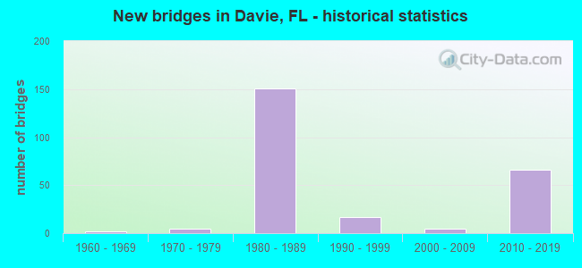
- New bridges - historical statistics
- 21960-1969
- 51970-1979
- 1511980-1989
- 171990-1999
- 52000-2009
- 662010-2019
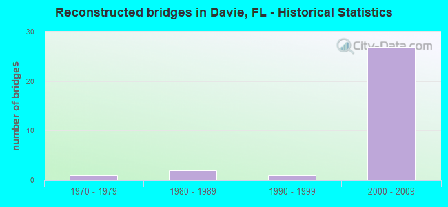
- Reconstructed bridges - Historical Statistics
- 11970-1979
- 21980-1989
- 11990-1999
- 272000-2009
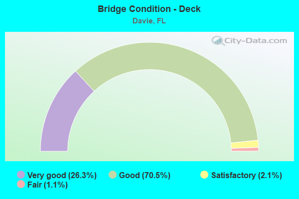
- Bridge Condition - Deck
- 26.3%Very good
- 70.5%Good
- 2.1%Satisfactory
- 1.1%Fair
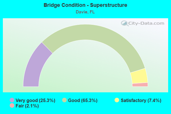
- Bridge Condition - Superstructure
- 25.3%Very good
- 65.3%Good
- 7.4%Satisfactory
- 2.1%Fair
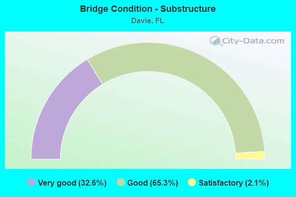
- Bridge Condition - Substructure
- 32.6%Very good
- 65.3%Good
- 2.1%Satisfactory
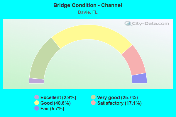
- Bridge Condition - Channel
- 2.9%Excellent
- 25.7%Very good
- 48.6%Good
- 17.1%Satisfactory
- 5.7%Fair
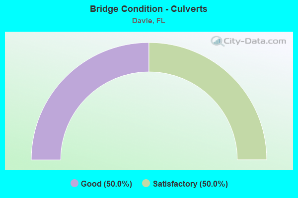
- Bridge Condition - Culverts
- 50.0%Good
- 50.0%Satisfactory
Find on map >> Show street view
Structure Number: 860433, Location: 0.2mi W of US-441 (Lat: 26.046267, Lng: -80.215131), Route carried "on" structure: State highway 848, Year Built: 1983, Status: Open, Structure Length: 8.41m (27.59ft), Average Daily Traffic: 19,500 (year 2020), Truck Traffic: 3%, Average Future Daily Traffic: 33,832 (year 2042), Design Load: HS 20, Features Intersected: Fl. Tpk. (SR-91), Facility Carried by Structure: EB Stirling Rd.
Minimum Vertical Clearance: 30+ m (98+ ft), Kilometerpoint: 3.660, Lanes on structure: 3, Lanes under structure: 8, Base Highway Network: Yes, Owner: State Highway Agency, Approaching Roadway Width: 12.3m (40.4ft), Material/Design: Prestressed concrete, Design/Construction: Stringer/Multi-beam, Number Of Spans In Main Unit: 4, Length of Maximum Span: 23.8m (78.1ft), Curb or Sidewalk Widths: Left: 0.0m, Right: 2.1m (6.9ft), Curb-To-Curb Width: 12.3m (40.4ft), Out-to-Out Width: 16.9m (55.4ft)
Condition: Deck: Good, Superstructure: Good, Substructure: Good, Operating Rating: 58.8 metric tons, Method Used To Determine Operating Rating: Load and Resistance Factor (LRFR), Inventory Rating: 45.4 metric tons, Method Used To Determine Inventory Rating: Load and Resistance Factor (LRFR), Structural Evaluation: Better than present minimum criteria, Deck Geometry: Meets minimum limits, Underclear: Equal to present minimum criteria, Approach Roadway Alignment: Equal to present desirable criteria, Designated Inspection Frequency: Every 24 months, Inspection Date: July 2021, Deck Structure Type: Concrete Cast-file-Place
Find on map >> Show street view
Structure Number: 860468, Location: I595 - SR-7 Interchange (Lat: 26.085117, Lng: -80.199583), Route carried "on" structure: Ramp Interstate 595, Year Built: 1988, Status: Open, Structure Length: 10.03m (32.91ft), Average Daily Traffic: 17,500 (year 2020), Truck Traffic: 6%, Average Future Daily Traffic: 30,362 (year 2042), Design Load: HS 20, Features Intersected: SR 84 EXIT RAMP TO SR 7
Minimum Vertical Clearance: 30+ m (98+ ft), Kilometerpoint: 0.175, Lanes on structure: 2, Lanes under structure: 1, Owner: State Highway Agency, Approaching Roadway Width: 12.2m (40.0ft), Skew: 9 degrees, Material/Design: Steel continuous, Design/Construction: Stringer/Multi-beam, Number Of Spans In Main Unit: 3, Length of Maximum Span: 47.6m (156.2ft), Curb-To-Curb Width: 12.2m (40.0ft), Out-to-Out Width: 13.0m (42.7ft)
Condition: Deck: Good, Superstructure: Good, Substructure: Good, Operating Rating: 46.1 metric tons, Method Used To Determine Operating Rating: Load Factor (LF), Inventory Rating: 27.7 metric tons, Method Used To Determine Inventory Rating: Load Factor (LF), Structural Evaluation: Equal to present minimum criteria, Deck Geometry: Superior to present desirable criteria, Underclear: Equal to present minimum criteria, Approach Roadway Alignment: Equal to present desirable criteria, Designated Inspection Frequency: Every 24 months, Inspection Date: September 2021, Deck Structure Type: Concrete Cast-file-Place
Find on map >> Show street view
Structure Number: 860469, Location: I-595 / SR-7 Interchange (Lat: 26.084289, Lng: -80.196039), Route carried "on" structure: Ramp Interstate 595, Year Built: 1988, Status: Open, Structure Length: 19.44m (63.78ft), Average Daily Traffic: 10,000 (year 2020), Truck Traffic: 6%, Average Future Daily Traffic: 17,350 (year 2042), Design Load: HS 20, Features Intersected: I-595 Ramps
Minimum Vertical Clearance: 5.49m (18.01ft), Kilometerpoint: 0.061, Lanes on structure: 2, Lanes under structure: 4, Owner: State Highway Agency, Approaching Roadway Width: 12.2m (40.0ft), Skew: 9 degrees, Material/Design: Steel continuous, Design/Construction: Stringer/Multi-beam, Number Of Spans In Main Unit: 5, Length of Maximum Span: 69.5m (228.0ft), Curb-To-Curb Width: 12.2m (40.0ft), Out-to-Out Width: 13.0m (42.7ft)
Condition: Deck: Good, Superstructure: Good, Substructure: Good, Operating Rating: 53.9 metric tons, Method Used To Determine Operating Rating: Load Factor (LF), Inventory Rating: 32.4 metric tons, Method Used To Determine Inventory Rating: Load Factor (LF), Structural Evaluation: Better than present minimum criteria, Deck Geometry: Superior to present desirable criteria, Underclear: Equal to present minimum criteria, Approach Roadway Alignment: Equal to present desirable criteria, Designated Inspection Frequency: Every 24 months, Inspection Date: August 2020, Deck Structure Type: Concrete Cast-file-Place
Find on map >> Show street view
Structure Number: 860475, Location: I-595 & SR-7 INTERCHANGE (Lat: 26.087200, Lng: -80.205083), Route carried "on" structure: State highway 84, Year Built: 1988, Year Reconstructed: 2012, Status: Open, Structure Length: 5.43m (17.81ft), Average Daily Traffic: 10,250 (year 2020), Truck Traffic: 7%, Average Future Daily Traffic: 17,784 (year 2042), Design Load: HL 93, Features Intersected: SR 7 SB RAMP TO SR 84 WB
Minimum Vertical Clearance: 30+ m (98+ ft), Kilometerpoint: 1.294, Lanes on structure: 3, Lanes under structure: 1, Owner: State Highway Agency, Approaching Roadway Width: 15.8m (51.8ft), Skew: 4 degrees, Material/Design: Prestressed concrete, Design/Construction: Stringer/Multi-beam, Number Of Spans In Main Unit: 3, Length of Maximum Span: 26.2m (86.0ft), Curb-To-Curb Width: 15.8m (51.8ft), Out-to-Out Width: 16.7m (54.8ft)
Condition: Deck: Good, Superstructure: Good, Substructure: Good, Operating Rating: 47.4 metric tons, Method Used To Determine Operating Rating: Load and Resistance Factor (LRFR), Inventory Rating: 42.8 metric tons, Method Used To Determine Inventory Rating: Load and Resistance Factor (LRFR), Structural Evaluation: Better than present minimum criteria, Deck Geometry: Better than present minimum criteria, Underclear: Better than present minimum criteria, Approach Roadway Alignment: Equal to present desirable criteria, Designated Inspection Frequency: Every 24 months, Inspection Date: September 2021, Deck Structure Type: Concrete Cast-file-Place
Find on map >> Show street view
Structure Number: 860476, Location: I-595 / US441 Interchange (Lat: 26.085692, Lng: -80.203231), Route carried "on" structure: Ramp Interstate 595, Year Built: 1988, Status: Open, Structure Length: 60.61m (198.85ft), Average Daily Traffic: 12,000 (year 2020), Truck Traffic: 6%, Average Future Daily Traffic: 20,820 (year 2042), Design Load: HS 20, Features Intersected: SR-869 & EB to NB ramp
Minimum Vertical Clearance: 5.00m (16.40ft), Kilometerpoint: 0.497, Lanes on structure: 2, Lanes under structure: 19, Owner: State Highway Agency, Approaching Roadway Width: 12.2m (40.0ft), Material/Design: Prestressed concrete continuous, Design/Construction: Segmental Box Girder, Number Of Spans In Main Unit: 13, Length of Maximum Span: 68.2m (223.8ft), Curb-To-Curb Width: 12.2m (40.0ft), Out-to-Out Width: 13.1m (43.0ft)
Condition: Deck: Good, Superstructure: Fair, Substructure: Good, Operating Rating: 57.2 metric tons, Method Used To Determine Operating Rating: Load Testing, Inventory Rating: 34.5 metric tons, Method Used To Determine Inventory Rating: Load Testing, Structural Evaluation: Somewhat better than minimum adequacy, Deck Geometry: Somewhat better than minimum adequacy, Underclear: Meets minimum limits, Approach Roadway Alignment: Equal to present desirable criteria, Designated Inspection Frequency: Every 24 months, Inspection Date: June 2021, Deck Structure Type: Concrete Cast-file-Place, Wearing Surface/Protective System: Wearing Surface: Epoxy Overlay
Find on map >> Show street view
Structure Number: 860477, Location: I-595 / SR-7 Interchange (Lat: 26.085778, Lng: -80.202353), Route carried "on" structure: Ramp Interstate 595, Year Built: 1988, Status: Open, Structure Length: 66.65m (218.67ft), Average Daily Traffic: 8,200 (year 2020), Truck Traffic: 8%, Average Future Daily Traffic: 14,227 (year 2042), Design Load: HS 20+Mod, Features Intersected: I-595, SR-7 & Connectors
Minimum Vertical Clearance: 30+ m (98+ ft), Kilometerpoint: 0.414, Lanes on structure: 2, Lanes under structure: 11, Owner: State Highway Agency, Approaching Roadway Width: 12.5m (41.0ft), Navigation Control: Yes ( Vertical Clearance: 9.4m (30.8ft), Horizontal Clearance: 12.2m (40.0ft)), Material/Design: Prestressed concrete continuous, Design/Construction: Segmental Box Girder, Number Of Spans In Main Unit: 13, Length of Maximum Span: 68.2m (223.8ft), Curb-To-Curb Width: 12.2m (40.0ft), Out-to-Out Width: 13.1m (43.0ft)
Condition: Deck: Good, Superstructure: Satisfactory, Substructure: Good, Channel: Very good, Operating Rating: 57.2 metric tons, Method Used To Determine Operating Rating: Load Testing, Inventory Rating: 34.5 metric tons, Method Used To Determine Inventory Rating: Load Testing, Structural Evaluation: Equal to present minimum criteria, Deck Geometry: Superior to present desirable criteria, Underclear: Meets minimum limits, Waterway Adequacy: Superior to present desirable criteria, Approach Roadway Alignment: Equal to present desirable criteria, Designated Inspection Frequency: Every 24 months, Underwater Inspection Frequency: Every 24 months, Inspection Date: June 2021, Underwater Inspection Date: June 2021, Deck Structure Type: Concrete Cast-file-Place, Wearing Surface/Protective System: Wearing Surface: Epoxy Overlay
Find on map >> Show street view
Structure Number: 860507, Location: .2 mi W of US-441 (Lat: 26.046572, Lng: -80.214328), Route carried "on" structure: State highway 848, Year Built: 1983, Status: Open, Structure Length: 8.41m (27.59ft), Average Daily Traffic: 19,500 (year 2020), Truck Traffic: 3%, Average Future Daily Traffic: 33,832 (year 2042), Design Load: HS 20, Features Intersected: Fl Tpk. (SR-91), Facility Carried by Structure: WB Stirling Rd.
Minimum Vertical Clearance: 30+ m (98+ ft), Kilometerpoint: 3.660, Lanes on structure: 3, Lanes under structure: 8, Owner: State Highway Agency, Approaching Roadway Width: 12.3m (40.4ft), Material/Design: Prestressed concrete, Design/Construction: Stringer/Multi-beam, Number Of Spans In Main Unit: 4, Length of Maximum Span: 23.8m (78.1ft), Curb or Sidewalk Widths: Left: 2.1m (6.9ft), Right: 0.0m, Curb-To-Curb Width: 12.3m (40.4ft), Out-to-Out Width: 16.9m (55.4ft)
Condition: Deck: Good, Superstructure: Satisfactory, Substructure: Good, Operating Rating: 58.8 metric tons, Method Used To Determine Operating Rating: Load and Resistance Factor (LRFR), Inventory Rating: 45.4 metric tons, Method Used To Determine Inventory Rating: Load and Resistance Factor (LRFR), Structural Evaluation: Equal to present minimum criteria, Deck Geometry: Meets minimum limits, Underclear: Equal to present minimum criteria, Approach Roadway Alignment: Equal to present desirable criteria, Designated Inspection Frequency: Every 24 months, Inspection Date: July 2021, Deck Structure Type: Concrete Cast-file-Place
Find on map >> Show street view
Structure Number: 86051, Location: I-75/SR869/I-595 Interchg (Lat: 26.122128, Lng: -80.342917), Route carried "on" structure: Ramp Interstate 75, Year Built: 1988, Status: Open, Structure Length: 15.21m (49.90ft), Average Daily Traffic: 13,000 (year 2020), Truck Traffic: 10%, Average Future Daily Traffic: 22,555 (year 2042), Design Load: HS 20, Features Intersected: WB SR84 & New River Cnl, Facility Carried by Structure: WB 595 TO NB SR869
Minimum Vertical Clearance: 30+ m (98+ ft), Kilometerpoint: 0.528, Lanes on structure: 2, Lanes under structure: 2, Owner: State Highway Agency, Approaching Roadway Width: 12.2m (40.0ft), Skew: 9 degrees, Material/Design: Prestressed concrete continuous, Design/Construction: Segmental Box Girder, Number Of Spans In Main Unit: 4, Length of Maximum Span: 55.5m (182.1ft), Curb-To-Curb Width: 12.2m (40.0ft), Out-to-Out Width: 13.0m (42.7ft)
Condition: Deck: Good, Superstructure: Satisfactory, Substructure: Very good, Channel: Very good, Operating Rating: 60.4 metric tons, Method Used To Determine Operating Rating: Load Testing, Inventory Rating: 35.9 metric tons, Method Used To Determine Inventory Rating: Load Testing, Structural Evaluation: Equal to present minimum criteria, Deck Geometry: Superior to present desirable criteria, Underclear: Superior to present desirable criteria, Waterway Adequacy: Superior to present desirable criteria, Approach Roadway Alignment: Equal to present desirable criteria, Designated Inspection Frequency: Every 24 months, Inspection Date: August 2021, Deck Structure Type: Concrete Cast-file-Place, Wearing Surface/Protective System: Wearing Surface: Epoxy Overlay
Find on map >> Show street view
Structure Number: 860519, Location: I-75/I-595 INTERCHANGE (Lat: 26.122822, Lng: -80.343950), Route carried "on" structure: Ramp Interstate 75, Year Built: 1988, Status: Open, Structure Length: 11.79m (38.68ft), Average Daily Traffic: 40,000 (year 2020), Truck Traffic: 6%, Average Future Daily Traffic: 69,400 (year 2042), Design Load: HS 20, Features Intersected: SR-84 WB and New River
Minimum Vertical Clearance: 6.86m (22.51ft), Kilometerpoint: 1.186, Lanes on structure: 3, Lanes under structure: 2, Owner: State Highway Agency, Approaching Roadway Width: 17.1m (56.1ft), Material/Design: Prestressed concrete continuous, Design/Construction: Segmental Box Girder, Number Of Spans In Main Unit: 4, Length of Maximum Span: 42.8m (140.4ft), Curb-To-Curb Width: 17.1m (56.1ft), Out-to-Out Width: 18.0m (59.1ft)
Condition: Deck: Good, Superstructure: Good, Substructure: Very good, Channel: Good, Operating Rating: 67.0 metric tons, Method Used To Determine Operating Rating: Load Testing, Inventory Rating: 39.2 metric tons, Method Used To Determine Inventory Rating: Load Testing, Structural Evaluation: Better than present minimum criteria, Deck Geometry: Superior to present desirable criteria, Underclear: Superior to present desirable criteria, Waterway Adequacy: Superior to present desirable criteria, Approach Roadway Alignment: Equal to present desirable criteria, Designated Inspection Frequency: Every 24 months, Inspection Date: August 2021, Deck Structure Type: Concrete Cast-file-Place, Wearing Surface/Protective System: Wearing Surface: Epoxy Overlay
Find on map >> Show street view
Structure Number: 860533, Location: 5.6 MILES NORTH OF SR-820 (Lat: 26.091231, Lng: -80.216647), Route carried "on" structure: State highway 91, Year Built: 1988, Year Reconstructed: 2014, Status: Open, Structure Length: 17.62m (57.81ft), Average Daily Traffic: 130,100 (year 2021), Truck Traffic: 13%, Average Future Daily Traffic: 225,724 (year 2042), Design Load: HS 20, Features Intersected: I-595 (SR-862) & CANAL
Minimum Vertical Clearance: 30+ m (98+ ft), Kilometerpoint: 13.609, Lanes on structure: 10, Lanes under structure: 16, Base Highway Network: Yes, Toll: On toll road, Owner: State Toll Authority, Approaching Roadway Width: 53.6m (175.9ft), Skew: 2 degrees, Material/Design: Prestressed concrete, Design/Construction: Stringer/Multi-beam, Number Of Spans In Main Unit: 5, Length of Maximum Span: 46.2m (151.6ft), Curb-To-Curb Width: 53.6m (175.9ft), Out-to-Out Width: 55.5m (182.1ft)
Condition: Deck: Good, Superstructure: Satisfactory, Substructure: Good, Channel: Good, Operating Rating: 39.8 metric tons, Method Used To Determine Operating Rating: Load and Resistance Factor (LRFR), Inventory Rating: 18.4 metric tons, Method Used To Determine Inventory Rating: Load and Resistance Factor (LRFR), Structural Evaluation: Meets minimum limits, Deck Geometry: Superior to present desirable criteria, Underclear: Meets minimum limits, Waterway Adequacy: Superior to present desirable criteria, Approach Roadway Alignment: Equal to present desirable criteria, Designated Inspection Frequency: Every 24 months, Underwater Inspection Frequency: Every 24 months, Inspection Date: September 2021, Underwater Inspection Date: September 2021, Deck Structure Type: Concrete Cast-file-Place
Find on map >> Show street view
Structure Number: 860559, Location: SR-91-I-595 INTERCHANGE (Lat: 26.082917, Lng: -80.216467), Route carried "on" structure: Ramp State highway 91, Year Built: 1989, Year Reconstructed: 2014, Status: Open, Structure Length: 35.45m (116.31ft), Average Daily Traffic: 17,500 (year 2020), Truck Traffic: 13%, Average Future Daily Traffic: 30,362 (year 2042), Design Load: HS 20+Mod, Features Intersected: SR-91 & RAMPS
Minimum Vertical Clearance: 30+ m (98+ ft), Kilometerpoint: 0.378, Lanes on structure: 2, Lanes under structure: 17, Toll: On toll road, Owner: State Toll Authority, Maintenance Responsibility: State Highway Agency, Approaching Roadway Width: 13.4m (44.0ft), Skew: 9 degrees, Material/Design: Prestressed concrete, Design/Construction: Stringer/Multi-beam, Number Of Spans In Main Unit: 14, Length of Maximum Span: 27.7m (90.9ft), Curb-To-Curb Width: 14.5m (47.6ft), Out-to-Out Width: 15.0m (49.2ft)
Condition: Deck: Good, Superstructure: Good, Substructure: Good, Operating Rating: 45.6 metric tons, Method Used To Determine Operating Rating: Load Factor (LF), Inventory Rating: 27.9 metric tons, Method Used To Determine Inventory Rating: Load Factor (LF), Structural Evaluation: Better than present minimum criteria, Deck Geometry: Superior to present desirable criteria, Underclear: Meets minimum limits, Approach Roadway Alignment: Meets minimum limits, Designated Inspection Frequency: Every 24 months, Inspection Date: May 2020, Deck Structure Type: Concrete Cast-file-Place
Find on map >> Show street view
Structure Number: 86056, Location: SR-91 I-595 INTERCHANGE (Lat: 26.088158, Lng: -80.210611), Route carried "on" structure: Ramp State highway 91, Year Built: 1990, Year Reconstructed: 2012, Status: Open, Structure Length: 23.62m (77.49ft), Average Daily Traffic: 1,600 (year 2020), Truck Traffic: 13%, Average Future Daily Traffic: 2,776 (year 2042), Design Load: HS 20, Features Intersected: None
Minimum Vertical Clearance: 30+ m (98+ ft), Kilometerpoint: 0.373, Lanes on structure: 3, Toll: On toll road, Owner: State Toll Authority, Maintenance Responsibility: State Highway Agency, Approaching Roadway Width: 17.6m (57.7ft), Material/Design: Concrete, Design/Construction: Slab, Number Of Spans In Main Unit: 9, Length of Maximum Span: 27.9m (91.5ft), Curb-To-Curb Width: 17.6m (57.7ft), Out-to-Out Width: 18.8m (61.7ft)
Condition: Deck: Good, Superstructure: Good, Substructure: Good, Operating Rating: 59.7 metric tons, Method Used To Determine Operating Rating: Load Factor (LF), Inventory Rating: 35.9 metric tons, Method Used To Determine Inventory Rating: Load Factor (LF), Structural Evaluation: Better than present minimum criteria, Deck Geometry: Superior to present desirable criteria, Approach Roadway Alignment: Better than present minimum criteria, Designated Inspection Frequency: Every 24 months, Inspection Date: August 2021, Deck Structure Type: Concrete Cast-file-Place
Find on map >> Show street view
Structure Number: 860561, Location: I-595-SR-91 INTERCHANGE (Lat: 26.089744, Lng: -80.212667), Route carried "on" structure: Ramp State highway 91, Year Built: 1990, Status: Open, Structure Length: 32.83m (107.71ft), Average Daily Traffic: 18,500 (year 2020), Truck Traffic: 13%, Average Future Daily Traffic: 32,098 (year 2042), Design Load: HS 20+Mod, Features Intersected: I-595-SR-91 ENT RAMP
Minimum Vertical Clearance: 6.22m (20.41ft), Kilometerpoint: 0.898, Lanes on structure: 2, Lanes under structure: 13, Toll: On toll road, Owner: State Toll Authority, Maintenance Responsibility: State Highway Agency, Approaching Roadway Width: 13.7m (44.9ft), Material/Design: Steel continuous, Design/Construction: Box Beam or Girders - Single/Spread, Number Of Spans In Main Unit: 7, Length of Maximum Span: 55.2m (181.1ft), Curb-To-Curb Width: 13.4m (44.0ft), Out-to-Out Width: 14.2m (46.6ft)
Condition: Deck: Good, Superstructure: Good, Substructure: Good, Inventory Rating: 60.1 metric tons, Method Used To Determine Inventory Rating: Load Factor (LF), Structural Evaluation: Better than present minimum criteria, Deck Geometry: Superior to present desirable criteria, Underclear: High priority of corrective action, Approach Roadway Alignment: Equal to present desirable criteria, Designated Inspection Frequency: Every 24 months, Critical Feature Inspection Frequency: Every 24 months, Inspection Date: September 2020, Critical Feature Inspection Date: September 2020, Deck Structure Type: Concrete Cast-file-Place
Find on map >> Show street view
Structure Number: 860563, Location: SR-91/I-595 INTERCHANGE (Lat: 26.089681, Lng: -80.212294), Route carried "on" structure: Ramp State highway 91, Year Built: 1990, Status: Open, Structure Length: 23.80m (78.08ft), Average Daily Traffic: 18,500 (year 2020), Truck Traffic: 13%, Average Future Daily Traffic: 32,098 (year 2042), Design Load: HS 20+Mod, Features Intersected: I-595, Facility Carried by Structure: I595 WB 55.343
Minimum Vertical Clearance: 5.21m (17.09ft), Kilometerpoint: 0.462, Lanes on structure: 2, Lanes under structure: 11, Toll: On toll road, Owner: State Toll Authority, Maintenance Responsibility: State Highway Agency, Approaching Roadway Width: 13.4m (44.0ft), Material/Design: Steel continuous, Design/Construction: Box Beam or Girders - Single/Spread, Number Of Spans In Main Unit: 3, Number Of Approach Spans: 1, Length of Maximum Span: 49.8m (163.4ft), Curb-To-Curb Width: 13.4m (44.0ft), Out-to-Out Width: 14.2m (46.6ft)
Condition: Deck: Satisfactory, Superstructure: Good, Substructure: Good, Operating Rating: 73.8 metric tons, Method Used To Determine Operating Rating: Load Factor (LF), Inventory Rating: 44.5 metric tons, Method Used To Determine Inventory Rating: Load Factor (LF), Structural Evaluation: Better than present minimum criteria, Deck Geometry: Superior to present desirable criteria, Underclear: Equal to present minimum criteria, Approach Roadway Alignment: Equal to present desirable criteria, Designated Inspection Frequency: Every 24 months, Critical Feature Inspection Frequency: Every 12 months, Inspection Date: November 2021, Critical Feature Inspection Date: November 2021, Deck Structure Type: Concrete Cast-file-Place
Find on map >> Show street view
Structure Number: 860565, Location: .2 mi W of Univ/SR 817 (Lat: 26.065081, Lng: -80.256939), Route carried "on" structure: Ramp State highway 818, Year Built: 1992, Status: Open, Structure Length: 3.11m (10.20ft), Average Daily Traffic: 900 (year 2020), Truck Traffic: 5%, Average Future Daily Traffic: 33,600 (year 2040), Design Load: HS 20+Mod, Features Intersected: C-11 Canal, Facility Carried by Structure: Griffin/Orange Con
Minimum Vertical Clearance: 30+ m (98+ ft), Kilometerpoint: 0.031, Lanes on structure: 4, Owner: State Highway Agency, Approaching Roadway Width: 6.8m (22.3ft), Skew: 20 degrees, Material/Design: Concrete continuous, Design/Construction: Slab, Number Of Spans In Main Unit: 3, Length of Maximum Span: 10.4m (34.1ft), Curb or Sidewalk Widths: Left: 2.4m (7.9ft), Right: 0.0m, Curb-To-Curb Width: 22.6m (74.1ft), Out-to-Out Width: 23.4m (76.8ft)
Condition: Deck: Good, Superstructure: Good, Substructure: Good, Channel: Satisfactory, Operating Rating: 55.3 metric tons, Method Used To Determine Operating Rating: Load Factor (LF), Inventory Rating: 33.6 metric tons, Method Used To Determine Inventory Rating: Load Factor (LF), Structural Evaluation: Better than present minimum criteria, Deck Geometry: Superior to present desirable criteria, Waterway Adequacy: Superior to present desirable criteria, Approach Roadway Alignment: Equal to present desirable criteria, Designated Inspection Frequency: Every 24 months, Underwater Inspection Frequency: Every 24 months, Inspection Date: April 2020, Underwater Inspection Date: April 2020, Deck Structure Type: Concrete Cast-file-Place
Find on map >> Show street view
Structure Number: 860566, Location: 0.2 mi east of University (Lat: 26.065078, Lng: -80.248900), Route carried "on" structure: Ramp State highway 818, Year Built: 1992, Status: Open, Structure Length: 3.11m (10.20ft), Average Daily Traffic: 1,879 (year 2020), Truck Traffic: 5%, Average Future Daily Traffic: 3,260 (year 2040), Design Load: HS 20+Mod, Features Intersected: C-11 Canal, Facility Carried by Structure: Griffin/Orange Con
Minimum Vertical Clearance: 30+ m (98+ ft), Kilometerpoint: 0.032, Lanes on structure: 4, Owner: State Highway Agency, Approaching Roadway Width: 6.8m (22.3ft), Skew: 20 degrees, Material/Design: Concrete continuous, Design/Construction: Slab, Number Of Spans In Main Unit: 3, Length of Maximum Span: 10.4m (34.1ft), Curb or Sidewalk Widths: Left: 2.4m (7.9ft), Right: 0.0m, Curb-To-Curb Width: 22.6m (74.1ft), Out-to-Out Width: 23.4m (76.8ft)
Condition: Deck: Good, Superstructure: Good, Substructure: Good, Channel: Good, Operating Rating: 55.3 metric tons, Method Used To Determine Operating Rating: Load Factor (LF), Inventory Rating: 33.6 metric tons, Method Used To Determine Inventory Rating: Load Factor (LF), Structural Evaluation: Better than present minimum criteria, Deck Geometry: Superior to present desirable criteria, Waterway Adequacy: Superior to present desirable criteria, Approach Roadway Alignment: Equal to present desirable criteria, Designated Inspection Frequency: Every 24 months, Underwater Inspection Frequency: Every 24 months, Inspection Date: April 2020, Underwater Inspection Date: April 2020, Deck Structure Type: Concrete Cast-file-Place
Find on map >> Show street view
Structure Number: 860567, Location: 1 mile North of SR-838 (Lat: 26.151250, Lng: -80.140847), Route carried "on" structure: State highway 811, Year Built: 2000, Status: Open, Structure Length: 1.76m (5.77ft), Average Daily Traffic: 13,900 (year 2020), Truck Traffic: 4%, Average Future Daily Traffic: 24,116 (year 2042), Design Load: HS 25 or greater, Features Intersected: S. Fork of Middle River
Minimum Vertical Clearance: 30+ m (98+ ft), Kilometerpoint: 1.574, Lanes on structure: 4, Owner: State Highway Agency, Approaching Roadway Width: 18.3m (60.0ft), Navigation Control: Yes ( Vertical Clearance: 1.9m (6.2ft), Horizontal Clearance: 7.5m (24.6ft)), Material/Design: Concrete continuous, Design/Construction: Slab, Number Of Spans In Main Unit: 2, Number Of Approach Spans: 2, Length of Maximum Span: 8.8m (28.9ft), Curb or Sidewalk Widths: Left: 1.8m (5.9ft), Right: 1.8m (5.9ft), Curb-To-Curb Width: 18.7m (61.4ft), Out-to-Out Width: 22.9m (75.1ft)
Condition: Deck: Good, Superstructure: Good, Substructure: Good, Channel: Good, Operating Rating: 84.1 metric tons, Method Used To Determine Operating Rating: Load Factor (LF), Inventory Rating: 50.4 metric tons, Method Used To Determine Inventory Rating: Load Factor (LF), Structural Evaluation: Better than present minimum criteria, Deck Geometry: Equal to present minimum criteria, Waterway Adequacy: Equal to present desirable criteria, Approach Roadway Alignment: Equal to present desirable criteria, Designated Inspection Frequency: Every 24 months, Underwater Inspection Frequency: Every 24 months, Inspection Date: July 2020, Underwater Inspection Date: July 2020, Deck Structure Type: Concrete Cast-file-Place
Find on map >> Show street view
Structure Number: 860571, Location: 50' WEST OF TURNPIKE (Lat: 26.065794, Lng: -80.215811), Route carried "on" structure: Ramp State highway 91, Year Built: 1989, Status: Open, Structure Length: 2.65m (8.69ft), Average Daily Traffic: 6,500 (year 2021), Truck Traffic: 11%, Average Future Daily Traffic: 11,278 (year 2042), Design Load: HS 20+Mod, Features Intersected: S NEW RIVER CANAL C-11, Facility Carried by Structure: TPK SB GRIF 53.95
Minimum Vertical Clearance: 30+ m (98+ ft), Kilometerpoint: 0.000, Lanes on structure: 3, Owner: State Toll Authority, Approaching Roadway Width: 11.6m (38.1ft), Material/Design: Concrete, Design/Construction: Slab, Number Of Spans In Main Unit: 3, Length of Maximum Span: 9.8m (32.2ft), Curb or Sidewalk Widths: Left: 1.4m (4.6ft), Right: 0.0m, Curb-To-Curb Width: 13.1m (43.0ft), Out-to-Out Width: 14.2m (46.6ft)
Condition: Deck: Good, Superstructure: Good, Substructure: Good, Channel: Good, Operating Rating: 43.5 metric tons, Method Used To Determine Operating Rating: Load Factor (LF), Inventory Rating: 26.3 metric tons, Method Used To Determine Inventory Rating: Load Factor (LF), Structural Evaluation: Equal to present minimum criteria, Deck Geometry: Somewhat better than minimum adequacy, Waterway Adequacy: Superior to present desirable criteria, Approach Roadway Alignment: Equal to present minimum criteria, Designated Inspection Frequency: Every 24 months, Underwater Inspection Frequency: Every 24 months, Inspection Date: September 2021, Underwater Inspection Date: September 2021, Deck Structure Type: Concrete Cast-file-Place
Find on map >> Show street view
Structure Number: 860572, Location: 50' EAST OF TURNPIKE (Lat: 26.065822, Lng: -80.215042), Route carried "on" structure: Ramp State highway 91, Year Built: 1989, Status: Open, Structure Length: 2.65m (8.69ft), Average Daily Traffic: 8,100 (year 2021), Truck Traffic: 11%, Average Future Daily Traffic: 14,054 (year 2042), Design Load: HS 20+Mod, Features Intersected: S NEW RIVER CANAL C-11, Facility Carried by Structure: TPK NB GRIF 53.95
Minimum Vertical Clearance: 30+ m (98+ ft), Kilometerpoint: 0.000, Lanes on structure: 3, Owner: State Toll Authority, Approaching Roadway Width: 11.6m (38.1ft), Material/Design: Concrete, Design/Construction: Slab, Number Of Spans In Main Unit: 3, Length of Maximum Span: 9.8m (32.2ft), Curb or Sidewalk Widths: Left: 0.0m, Right: 1.4m (4.6ft), Curb-To-Curb Width: 12.5m (41.0ft), Out-to-Out Width: 15.1m (49.5ft)
Condition: Deck: Good, Superstructure: Good, Substructure: Good, Channel: Good, Operating Rating: 43.5 metric tons, Method Used To Determine Operating Rating: Load Factor (LF), Inventory Rating: 26.3 metric tons, Method Used To Determine Inventory Rating: Load Factor (LF), Structural Evaluation: Equal to present minimum criteria, Deck Geometry: Meets minimum limits, Waterway Adequacy: Superior to present desirable criteria, Approach Roadway Alignment: Equal to present minimum criteria, Designated Inspection Frequency: Every 24 months, Underwater Inspection Frequency: Every 24 months, Inspection Date: September 2021, Underwater Inspection Date: September 2021, Deck Structure Type: Concrete Cast-file-Place
Find on map >> Show street view
Structure Number: 860573, Location: I-595 & SR-817 Interchang (Lat: 26.096861, Lng: -80.250667), Route carried "on" structure: Ramp State highway 817, Year Built: 1989, Status: Open, Structure Length: 13.59m (44.59ft), Average Daily Traffic: 6,900 (year 2020), Truck Traffic: 4%, Average Future Daily Traffic: 11,972 (year 2042), Design Load: HS 20, Features Intersected: Plaza Drive
Minimum Vertical Clearance: 30+ m (98+ ft), Kilometerpoint: 0.192, Lanes on structure: 1, Lanes under structure: 6, Owner: State Highway Agency, Approaching Roadway Width: 8.2m (26.9ft), Material/Design: Prestressed concrete, Design/Construction: Stringer/Multi-beam, Number Of Spans In Main Unit: 7, Length of Maximum Span: 20.7m (67.9ft), Curb-To-Curb Width: 8.2m (26.9ft), Out-to-Out Width: 9.2m (30.2ft)
Condition: Deck: Very good, Superstructure: Good, Substructure: Good, Operating Rating: 49.1 metric tons, Method Used To Determine Operating Rating: Load Factor (LF), Inventory Rating: 43.5 metric tons, Method Used To Determine Inventory Rating: Load Factor (LF), Structural Evaluation: Better than present minimum criteria, Deck Geometry: Superior to present desirable criteria, Underclear: High priority of corrective action, Approach Roadway Alignment: Equal to present desirable criteria, Designated Inspection Frequency: Every 24 months, Inspection Date: Febuary 2020, Deck Structure Type: Concrete Cast-file-Place
Find on map >> Show street view
Structure Number: 860581, Location: SR 823 over C-11 Canal. (Lat: 26.063806, Lng: -80.313475), Route carried "on" structure: State highway 823, Year Built: 1990, Status: Open, Structure Length: 3.66m (12.01ft), Average Daily Traffic: 38,000 (year 2020), Truck Traffic: 4%, Average Future Daily Traffic: 65,930 (year 2042), Design Load: HS 20+Mod, Features Intersected: C-11 CANAL
Minimum Vertical Clearance: 30+ m (98+ ft), Kilometerpoint: 11.856, Lanes on structure: 10, Base Highway Network: Yes, Owner: State Highway Agency, Approaching Roadway Width: 32.0m (105.0ft), Skew: 20 degrees, Material/Design: Prestressed concrete, Design/Construction: Stringer/Multi-beam, Number Of Spans In Main Unit: 3, Length of Maximum Span: 12.2m (40.0ft), Curb or Sidewalk Widths: Left: 1.5m (4.9ft), Right: 1.8m (5.9ft), Curb-To-Curb Width: 47.2m (154.9ft), Out-to-Out Width: 51.1m (167.7ft)
Condition: Deck: Good, Superstructure: Good, Substructure: Good, Channel: Good, Operating Rating: 58.4 metric tons, Method Used To Determine Operating Rating: Load Factor (LF), Inventory Rating: 44.9 metric tons, Method Used To Determine Inventory Rating: Load Factor (LF), Structural Evaluation: Better than present minimum criteria, Deck Geometry: Superior to present desirable criteria, Waterway Adequacy: Superior to present desirable criteria, Approach Roadway Alignment: Equal to present desirable criteria, Designated Inspection Frequency: Every 24 months, Underwater Inspection Frequency: Every 24 months, Inspection Date: March 2020, Underwater Inspection Date: March 2020, Deck Structure Type: Concrete Cast-file-Place
Find on map >> Show street view
Structure Number: 860582, Location: 0.5 MI W OF FLAMINGO ROAD (Lat: 26.063736, Lng: -80.317386), Route carried "on" structure: Ramp State highway 818, Year Built: 1990, Status: Open, Structure Length: 3.20m (10.50ft), Average Daily Traffic: 3,900 (year 2020), Truck Traffic: 5%, Average Future Daily Traffic: 15,600 (year 2040), Design Load: HS 20+Mod, Features Intersected: C-11 Canal
Minimum Vertical Clearance: 30+ m (98+ ft), Kilometerpoint: 0.023, Lanes on structure: 4, Owner: State Highway Agency, Approaching Roadway Width: 14.6m (47.9ft), Skew: 20 degrees, Material/Design: Concrete continuous, Design/Construction: Slab, Number Of Spans In Main Unit: 3, Length of Maximum Span: 10.7m (35.1ft), Curb or Sidewalk Widths: Left: 2.4m (7.9ft), Right: 0.0m, Curb-To-Curb Width: 22.6m (74.1ft), Out-to-Out Width: 23.4m (76.8ft)
Condition: Deck: Good, Superstructure: Good, Substructure: Good, Channel: Satisfactory, Operating Rating: 67.0 metric tons, Method Used To Determine Operating Rating: Load Factor (LF), Inventory Rating: 40.2 metric tons, Method Used To Determine Inventory Rating: Load Factor (LF), Structural Evaluation: Better than present minimum criteria, Deck Geometry: Superior to present desirable criteria, Waterway Adequacy: Superior to present desirable criteria, Approach Roadway Alignment: Equal to present desirable criteria, Designated Inspection Frequency: Every 24 months, Underwater Inspection Frequency: Every 24 months, Inspection Date: March 2020, Underwater Inspection Date: March 2020, Deck Structure Type: Concrete Cast-file-Place
Find on map >> Show street view
Structure Number: 860583, Location: 2 MI East of I-75 (Lat: 26.063753, Lng: -80.310422), Route carried "on" structure: Ramp State highway 818, Year Built: 1990, Status: Open, Structure Length: 3.20m (10.50ft), Average Daily Traffic: 3,900 (year 2018), Truck Traffic: 5%, Average Future Daily Traffic: 27,200 (year 2040), Design Load: HS 20+Mod, Features Intersected: C-11 Canal, Facility Carried by Structure: Griffin Rd/ Orange
Minimum Vertical Clearance: 30+ m (98+ ft), Kilometerpoint: 0.032, Lanes on structure: 4, Owner: State Highway Agency, Approaching Roadway Width: 12.8m (42.0ft), Skew: 20 degrees, Material/Design: Concrete continuous, Design/Construction: Slab, Number Of Spans In Main Unit: 3, Length of Maximum Span: 10.7m (35.1ft), Curb or Sidewalk Widths: Left: 2.4m (7.9ft), Right: 0.0m, Curb-To-Curb Width: 22.6m (74.1ft), Out-to-Out Width: 23.4m (76.8ft)
Condition: Deck: Good, Superstructure: Good, Substructure: Good, Channel: Satisfactory, Operating Rating: 67.0 metric tons, Method Used To Determine Operating Rating: Load Factor (LF), Inventory Rating: 40.2 metric tons, Method Used To Determine Inventory Rating: Load Factor (LF), Structural Evaluation: Better than present minimum criteria, Deck Geometry: Superior to present desirable criteria, Waterway Adequacy: Superior to present desirable criteria, Approach Roadway Alignment: Equal to present desirable criteria, Designated Inspection Frequency: Every 24 months, Underwater Inspection Frequency: Every 24 months, Inspection Date: Febuary 2022, Underwater Inspection Date: Febuary 2022, Deck Structure Type: Concrete Cast-file-Place
Find on map >> Show street view
Structure Number: 860584, Location: 0.2 MI EAST OF SR-823 (Lat: 26.063706, Lng: -80.309431), Route carried "on" structure: State highway 818, Year Built: 1990, Status: Open, Structure Length: 3.66m (12.01ft), Average Daily Traffic: 30,000 (year 2020), Truck Traffic: 6%, Average Future Daily Traffic: 52,050 (year 2042), Design Load: HS 20+Mod, Features Intersected: Spur Canal 11-S
Minimum Vertical Clearance: 30+ m (98+ ft), Kilometerpoint: 0.375, Lanes on structure: 7, Base Highway Network: Yes, Owner: State Highway Agency, Approaching Roadway Width: 27.4m (89.9ft), Skew: 20 degrees, Material/Design: Concrete continuous, Design/Construction: Slab, Number Of Spans In Main Unit: 3, Length of Maximum Span: 12.2m (40.0ft), Curb or Sidewalk Widths: Left: 0.0m, Right: 1.8m (5.9ft), Curb-To-Curb Width: 41.5m (136.2ft), Out-to-Out Width: 42.6m (139.8ft)
Condition: Deck: Good, Superstructure: Good, Substructure: Good, Channel: Satisfactory, Operating Rating: 54.3 metric tons, Method Used To Determine Operating Rating: Load Factor (LF), Inventory Rating: 32.6 metric tons, Method Used To Determine Inventory Rating: Load Factor (LF), Structural Evaluation: Better than present minimum criteria, Deck Geometry: Superior to present desirable criteria, Waterway Adequacy: Superior to present desirable criteria, Approach Roadway Alignment: Equal to present desirable criteria, Designated Inspection Frequency: Every 24 months, Underwater Inspection Frequency: Every 24 months, Inspection Date: March 2020, Underwater Inspection Date: March 2020, Deck Structure Type: Concrete Cast-file-Place
Find on map >> Show street view
Structure Number: 860597, Location: 0.4 mi. West of Davie Rd. (Lat: 26.065278, Lng: -80.237500), Route carried "on" structure: Ramp State highway 818, Year Built: 1999, Status: Open, Structure Length: 2.96m (9.71ft), Average Daily Traffic: 7,100 (year 2021), Truck Traffic: 4%, Average Future Daily Traffic: 8,400 (year 2042), Design Load: HS 25 or greater, Features Intersected: C-11 Canal, Facility Carried by Structure: Griffin-Orange Con
Minimum Vertical Clearance: 30+ m (98+ ft), Kilometerpoint: 0.021, Lanes on structure: 4, Owner: State Highway Agency, Approaching Roadway Width: 20.1m (65.9ft), Skew: 20 degrees, Material/Design: Concrete continuous, Design/Construction: Slab, Number Of Spans In Main Unit: 3, Length of Maximum Span: 11.7m (38.4ft), Curb or Sidewalk Widths: Left: 2.4m (7.9ft), Right: 0.0m, Curb-To-Curb Width: 20.1m (65.9ft), Out-to-Out Width: 23.5m (77.1ft)
Condition: Deck: Satisfactory, Superstructure: Good, Substructure: Good, Channel: Very good, Operating Rating: 65.6 metric tons, Method Used To Determine Operating Rating: Load Factor (LF), Inventory Rating: 39.3 metric tons, Method Used To Determine Inventory Rating: Load Factor (LF), Structural Evaluation: Better than present minimum criteria, Deck Geometry: Superior to present desirable criteria, Waterway Adequacy: Better than present minimum criteria, Approach Roadway Alignment: Equal to present desirable criteria, Designated Inspection Frequency: Every 24 months, Underwater Inspection Frequency: Every 24 months, Inspection Date: April 2021, Underwater Inspection Date: April 2021, Deck Structure Type: Concrete Cast-file-Place
Find on map >> Show street view
Structure Number: 860626, Location: 0.3 mi W of Pine Island (Lat: 26.064778, Lng: -80.265208), Route carried "on" structure: Ramp State highway 818, Year Built: 2002, Status: Open, Structure Length: 3.33m (10.93ft), Average Daily Traffic: 10,000 (year 2020), Truck Traffic: 5%, Average Future Daily Traffic: 20,000 (year 2042), Design Load: HS 20+Mod, Features Intersected: C-11 Canal, Facility Carried by Structure: Griffin/Orange Con
Minimum Vertical Clearance: 30+ m (98+ ft), Kilometerpoint: 0.024, Lanes on structure: 4, Owner: State Highway Agency, Approaching Roadway Width: 8.2m (26.9ft), Skew: 20 degrees, Material/Design: Concrete continuous, Design/Construction: Slab, Number Of Spans In Main Unit: 3, Length of Maximum Span: 11.7m (38.4ft), Curb or Sidewalk Widths: Left: 1.8m (5.9ft), Right: 1.8m (5.9ft), Curb-To-Curb Width: 23.1m (75.8ft), Out-to-Out Width: 27.6m (90.6ft)
Condition: Deck: Very good, Superstructure: Very good, Substructure: Good, Channel: Fair, Operating Rating: 80.3 metric tons, Method Used To Determine Operating Rating: Load Factor (LF), Inventory Rating: 48.2 metric tons, Method Used To Determine Inventory Rating: Load Factor (LF), Structural Evaluation: Better than present minimum criteria, Deck Geometry: Superior to present desirable criteria, Waterway Adequacy: Superior to present desirable criteria, Approach Roadway Alignment: Equal to present desirable criteria, Designated Inspection Frequency: Every 24 months, Underwater Inspection Frequency: Every 24 months, Inspection Date: August 2020, Underwater Inspection Date: August 2020, Deck Structure Type: Concrete Cast-file-Place
Find on map >> Show street view
Structure Number: 860627, Location: 1 mile South of I 595 (Lat: 26.066111, Lng: -80.207778), Route carried "on" structure: US 441, Year Built: 2001, Status: Open, Structure Length: 3.20m (10.50ft), Average Daily Traffic: 51,000 (year 2021), Truck Traffic: 7%, Average Future Daily Traffic: 88,485 (year 2042), Design Load: HS 25 or greater, Features Intersected: Dania Cut Off Canal
Minimum Vertical Clearance: 30+ m (98+ ft), Kilometerpoint: 10.366, Lanes on structure: 7, Base Highway Network: Yes, Owner: State Highway Agency, Approaching Roadway Width: 31.2m (102.4ft), Skew: 20 degrees, Material/Design: Concrete continuous, Design/Construction: Slab, Number Of Spans In Main Unit: 3, Length of Maximum Span: 10.7m (35.1ft), Curb or Sidewalk Widths: Left: 1.8m (5.9ft), Right: 1.8m (5.9ft), Curb-To-Curb Width: 31.2m (102.4ft), Out-to-Out Width: 36.6m (120.1ft)
Condition: Deck: Good, Superstructure: Good, Substructure: Good, Channel: Good, Operating Rating: 78.4 metric tons, Method Used To Determine Operating Rating: Load Factor (LF), Inventory Rating: 47.0 metric tons, Method Used To Determine Inventory Rating: Load Factor (LF), Structural Evaluation: Better than present minimum criteria, Deck Geometry: Better than present minimum criteria, Waterway Adequacy: Superior to present desirable criteria, Approach Roadway Alignment: Equal to present desirable criteria, Designated Inspection Frequency: Every 24 months, Underwater Inspection Frequency: Every 24 months, Inspection Date: October 2021, Underwater Inspection Date: October 2021, Deck Structure Type: Concrete Cast-file-Place
Find on map >> Show street view
Structure Number: 860639, Location: 0.5 Mi. East of I-75 (Lat: 26.063306, Lng: -80.342000), Route carried "on" structure: County highway , Year Built: 2009, Status: Open, Structure Length: 2.83m (9.28ft), Average Daily Traffic: 3,900 (year 2021), Truck Traffic: 5%, Average Future Daily Traffic: 15,600 (year 2042), Design Load: HL 93, Features Intersected: C-11 Canal, Facility Carried by Structure: 818/OrangeAve.conn
Minimum Vertical Clearance: 30+ m (98+ ft), Kilometerpoint: 0.014, Lanes on structure: 4, Owner: County Highway Agency, Approaching Roadway Width: 20.0m (65.6ft), Skew: 20 degrees, Material/Design: Concrete continuous, Design/Construction: Slab, Number Of Spans In Main Unit: 3, Length of Maximum Span: 9.4m (30.8ft), Curb or Sidewalk Widths: Left: 3.7m (12.1ft), Right: 1.5m (4.9ft), Curb-To-Curb Width: 20.0m (65.6ft), Out-to-Out Width: 24.4m (80.1ft)
Condition: Deck: Very good, Superstructure: Very good, Substructure: Very good, Channel: Good, Operating Rating: 62.9 metric tons, Method Used To Determine Operating Rating: Load and Resistance Factor (LRFR), Inventory Rating: 48.4 metric tons, Method Used To Determine Inventory Rating: Load and Resistance Factor (LRFR), Structural Evaluation: Equal to present desirable criteria, Deck Geometry: Better than present minimum criteria, Waterway Adequacy: Equal to present desirable criteria, Approach Roadway Alignment: Equal to present desirable criteria, Designated Inspection Frequency: Every 24 months, Underwater Inspection Frequency: Every 24 months, Inspection Date: July 2021, Underwater Inspection Date: July 2021, Deck Structure Type: Concrete Cast-file-Place
Find on map >> Show street view
Structure Number: 860645, Location: Pine Island Rd. & SR84 WB (Lat: 26.103547, Lng: -80.266711), Route carried "on" structure: Ramp Interstate 595, Year Built: 2010, Status: Open, Structure Length: 16.50m (54.13ft), Average Daily Traffic: 12,500 (year 2020), Truck Traffic: 2%, Average Future Daily Traffic: 21,688 (year 2042), Design Load: HL 93, Features Intersected: WB SR-84
Minimum Vertical Clearance: 30+ m (98+ ft), Kilometerpoint: 0.000, Lanes on structure: 2, Lanes under structure: 2, Owner: State Highway Agency, Approaching Roadway Width: 12.2m (40.0ft), Material/Design: Steel continuous, Design/Construction: Stringer/Multi-beam, Number Of Spans In Main Unit: 4, Length of Maximum Span: 50.3m (165.0ft), Curb-To-Curb Width: 12.2m (40.0ft), Out-to-Out Width: 13.1m (43.0ft)
Condition: Deck: Very good, Superstructure: Very good, Substructure: Very good, Operating Rating: 51.6 metric tons, Method Used To Determine Operating Rating: Load and Resistance Factor (LRFR), Inventory Rating: 39.6 metric tons, Method Used To Determine Inventory Rating: Load and Resistance Factor (LRFR), Structural Evaluation: Equal to present desirable criteria, Deck Geometry: Superior to present desirable criteria, Underclear: Meets minimum limits, Approach Roadway Alignment: Better than present minimum criteria, Designated Inspection Frequency: Every 24 months, Inspection Date: May 2021, Deck Structure Type: Concrete Cast-file-Place
Find on map >> Show street view
Structure Number: 860648, Location: I-595 and Pine Island Rd. (Lat: 26.103058, Lng: -80.265428), Route carried "on" structure: Interstate 595, Year Built: 2010, Status: Open, Structure Length: 11.78m (38.65ft), Average Daily Traffic: 55,500 (year 2020), Truck Traffic: 11%, Average Future Daily Traffic: 96,293 (year 2042), Design Load: HL 93, Features Intersected: Pine Island Road
Minimum Vertical Clearance: 30+ m (98+ ft), Kilometerpoint: 6.692, Lanes on structure: 5, Lanes under structure: 10, Base Highway Network: Yes, Owner: State Highway Agency, Approaching Roadway Width: 24.4m (80.1ft), Material/Design: Steel continuous, Design/Construction: Stringer/Multi-beam, Number Of Spans In Main Unit: 3, Length of Maximum Span: 47.2m (154.9ft), Curb-To-Curb Width: 24.4m (80.1ft), Out-to-Out Width: 25.4m (83.3ft)
Condition: Deck: Good, Superstructure: Very good, Substructure: Very good, Operating Rating: 59.1 metric tons, Method Used To Determine Operating Rating: Load and Resistance Factor (LRFR), Inventory Rating: 38.6 metric tons, Method Used To Determine Inventory Rating: Load and Resistance Factor (LRFR), Structural Evaluation: Equal to present desirable criteria, Deck Geometry: Equal to present minimum criteria, Underclear: Somewhat better than minimum adequacy, Approach Roadway Alignment: Equal to present desirable criteria, Designated Inspection Frequency: Every 24 months, Inspection Date: May 2021, Deck Structure Type: Concrete Cast-file-Place
Find on map >> Show street view
Structure Number: 860649, Location: 1Mi W of University Dr. (Lat: 26.102858, Lng: -80.265539), Route carried "on" structure: Interstate 595, Year Built: 2010, Status: Open, Structure Length: 10.24m (33.60ft), Average Daily Traffic: 7,108 (year 2020), Truck Traffic: 4%, Average Future Daily Traffic: 12,332 (year 2042), Design Load: HL 93, Features Intersected: Pine Island Road
Minimum Vertical Clearance: 30+ m (98+ ft), Kilometerpoint: 7.997, Lanes on structure: 3, Lanes under structure: 12, Base Highway Network: Yes, Toll: On toll road, Owner: State Highway Agency, Approaching Roadway Width: 17.1m (56.1ft), Material/Design: Steel continuous, Design/Construction: Stringer/Multi-beam, Number Of Spans In Main Unit: 3, Length of Maximum Span: 48.2m (158.1ft), Curb-To-Curb Width: 17.1m (56.1ft), Out-to-Out Width: 18.0m (59.1ft)
Condition: Deck: Very good, Superstructure: Very good, Substructure: Very good, Operating Rating: 43.5 metric tons, Method Used To Determine Operating Rating: Load and Resistance Factor (LRFR), Inventory Rating: 33.3 metric tons, Method Used To Determine Inventory Rating: Load and Resistance Factor (LRFR), Structural Evaluation: Equal to present desirable criteria, Deck Geometry: Equal to present minimum criteria, Underclear: Equal to present minimum criteria, Approach Roadway Alignment: Equal to present desirable criteria, Designated Inspection Frequency: Every 24 months, Inspection Date: March 2021, Deck Structure Type: Concrete Cast-file-Place
Find on map >> Show street view
Structure Number: 86065, Location: 1Mi W of University Dr. (Lat: 26.102472, Lng: -80.265581), Route carried "on" structure: Ramp Interstate 595, Year Built: 2011, Status: Open, Structure Length: 12.44m (40.81ft), Average Daily Traffic: 10,000 (year 2020), Truck Traffic: 4%, Average Future Daily Traffic: 17,350 (year 2042), Design Load: HL 93, Features Intersected: Pine Island Road
Minimum Vertical Clearance: 30+ m (98+ ft), Kilometerpoint: 1.028, Lanes on structure: 1, Lanes under structure: 10, Owner: State Highway Agency, Approaching Roadway Width: 8.2m (26.9ft), Material/Design: Steel continuous, Design/Construction: Stringer/Multi-beam, Number Of Spans In Main Unit: 3, Length of Maximum Span: 48.2m (158.1ft), Curb-To-Curb Width: 8.2m (26.9ft), Out-to-Out Width: 9.2m (30.2ft)
Condition: Deck: Very good, Superstructure: Very good, Substructure: Good, Operating Rating: 44.1 metric tons, Method Used To Determine Operating Rating: Load and Resistance Factor (LRFR), Inventory Rating: 33.9 metric tons, Method Used To Determine Inventory Rating: Load and Resistance Factor (LRFR), Structural Evaluation: Better than present minimum criteria, Deck Geometry: Superior to present desirable criteria, Underclear: Meets minimum limits, Approach Roadway Alignment: Equal to present desirable criteria, Designated Inspection Frequency: Every 24 months, Inspection Date: August 2021, Deck Structure Type: Concrete Cast-file-Place
Find on map >> Show street view
Structure Number: 860651, Location: 1.2Mi. W of University Dr (Lat: 26.104083, Lng: -80.271994), Route carried "on" structure: Ramp Interstate 595, Year Built: 2013, Status: Open, Structure Length: 16.76m (54.99ft), Average Daily Traffic: 10,000 (year 2020), Truck Traffic: 4%, Average Future Daily Traffic: 17,350 (year 2042), Design Load: HL 93, Features Intersected: SR84 EB to I595 EB
Minimum Vertical Clearance: 30+ m (98+ ft), Kilometerpoint: 0.357, Lanes on structure: 1, Lanes under structure: 1, Owner: State Highway Agency, Approaching Roadway Width: 8.2m (26.9ft), Material/Design: Steel continuous, Design/Construction: Stringer/Multi-beam, Number Of Spans In Main Unit: 3, Length of Maximum Span: 70.1m (230.0ft), Curb-To-Curb Width: 8.2m (26.9ft), Out-to-Out Width: 9.1m (29.9ft)
Condition: Deck: Very good, Superstructure: Very good, Substructure: Very good, Operating Rating: 52.3 metric tons, Method Used To Determine Operating Rating: Load and Resistance Factor (LRFR), Inventory Rating: 40.2 metric tons, Method Used To Determine Inventory Rating: Load and Resistance Factor (LRFR), Structural Evaluation: Equal to present desirable criteria, Deck Geometry: Superior to present desirable criteria, Underclear: Somewhat better than minimum adequacy, Approach Roadway Alignment: Equal to present desirable criteria, Designated Inspection Frequency: Every 24 months, Critical Feature Inspection Frequency: Every 24 months, Inspection Date: September 2021, Critical Feature Inspection Date: September 2021, Deck Structure Type: Concrete Cast-file-Place
Find on map >> Show street view
Structure Number: 860652, Location: Direct Conn. E. of Davie (Lat: 26.091781, Lng: -80.220117), Route carried "on" structure: Ramp Other road 595, Year Built: 2013, Status: Open, Structure Length: 12.22m (40.09ft), Average Daily Traffic: 1,700 (year 2020), Truck Traffic: 10%, Average Future Daily Traffic: 2,950 (year 2042), Design Load: HL 93, Features Intersected: I-595, Facility Carried by Structure: Express Lane Ramp
Minimum Vertical Clearance: 30+ m (98+ ft), Kilometerpoint: 0.217, Lanes on structure: 2, Lanes under structure: 5, Toll: On toll road, Owner: State Highway Agency, Approaching Roadway Width: 17.3m (56.8ft), Material/Design: Steel continuous, Design/Construction: Box Beam or Girders - Single/Spread, Number Of Spans In Main Unit: 2, Length of Maximum Span: 72.9m (239.2ft), Curb-To-Curb Width: 17.3m (56.8ft), Out-to-Out Width: 18.2m (59.7ft)
Condition: Deck: Very good, Superstructure: Very good, Substructure: Very good, Operating Rating: 44.5 metric tons, Method Used To Determine Operating Rating: Load and Resistance Factor (LRFR), Inventory Rating: 34.3 metric tons, Method Used To Determine Inventory Rating: Load and Resistance Factor (LRFR), Structural Evaluation: Equal to present desirable criteria, Deck Geometry: Superior to present desirable criteria, Underclear: Meets minimum limits, Approach Roadway Alignment: Equal to present desirable criteria, Designated Inspection Frequency: Every 24 months, Critical Feature Inspection Frequency: Every 24 months, Inspection Date: November 2021, Critical Feature Inspection Date: November 2021, Deck Structure Type: Concrete Cast-file-Place
Find on map >> Show street view
Structure Number: 860653, Location: I595 Exp. ramp R-9 To TPK (Lat: 26.089211, Lng: -80.216425), Route carried "on" structure: Ramp Interstate 595, Year Built: 2013, Status: Open, Structure Length: 63.79m (209.28ft), Average Daily Traffic: 1,700 (year 2020), Truck Traffic: 10%, Average Future Daily Traffic: 2,950 (year 2042), Design Load: HL 93, Features Intersected: TPK SB SR84 EB I595EB
Minimum Vertical Clearance: 30+ m (98+ ft), Kilometerpoint: 0.333, Lanes on structure: 1, Lanes under structure: 12, Toll: On toll road, Owner: State Highway Agency, Approaching Roadway Width: 10.1m (33.1ft), Material/Design: Steel continuous, Design/Construction: Box Beam or Girders - Single/Spread, Number Of Spans In Main Unit: 9, Length of Maximum Span: 92.7m (304.1ft), Curb-To-Curb Width: 10.1m (33.1ft), Out-to-Out Width: 11.0m (36.1ft)
Condition: Deck: Very good, Superstructure: Very good, Substructure: Very good, Operating Rating: 43.1 metric tons, Method Used To Determine Operating Rating: Load and Resistance Factor (LRFR), Inventory Rating: 33.3 metric tons, Method Used To Determine Inventory Rating: Load and Resistance Factor (LRFR), Structural Evaluation: Equal to present desirable criteria, Deck Geometry: Superior to present desirable criteria, Underclear: Meets minimum limits, Approach Roadway Alignment: Equal to present desirable criteria, Designated Inspection Frequency: Every 24 months, Critical Feature Inspection Frequency: Every 24 months, Inspection Date: November 2021, Critical Feature Inspection Date: November 2021, Deck Structure Type: Concrete Cast-file-Place
Find on map >> Show street view
Structure Number: 860654, Location: I595 Exp. Lane Conn. TPK (Lat: 26.092561, Lng: -80.216986), Route carried "on" structure: Ramp Interstate 595, Year Built: 2013, Status: Open, Structure Length: 51.54m (169.09ft), Average Daily Traffic: 1,600 (year 2020), Truck Traffic: 10%, Average Future Daily Traffic: 2,776 (year 2042), Design Load: HL 93, Features Intersected: New River Canal
Minimum Vertical Clearance: 30+ m (98+ ft), Kilometerpoint: 0.227, Lanes on structure: 1, Lanes under structure: 24, Toll: On toll road, Owner: State Highway Agency, Approaching Roadway Width: 10.1m (33.1ft), Material/Design: Steel continuous, Design/Construction: Box Beam or Girders - Single/Spread, Number Of Spans In Main Unit: 7, Length of Maximum Span: 91.7m (300.9ft), Curb-To-Curb Width: 10.1m (33.1ft), Out-to-Out Width: 11.0m (36.1ft)
Condition: Deck: Very good, Superstructure: Very good, Substructure: Very good, Channel: Very good, Operating Rating: 44.5 metric tons, Method Used To Determine Operating Rating: Load and Resistance Factor (LRFR), Inventory Rating: 34.3 metric tons, Method Used To Determine Inventory Rating: Load and Resistance Factor (LRFR), Structural Evaluation: Equal to present desirable criteria, Deck Geometry: Superior to present desirable criteria, Underclear: High priority of corrective action, Approach Roadway Alignment: Equal to present desirable criteria, Designated Inspection Frequency: Every 24 months, Critical Feature Inspection Frequency: Every 24 months, Underwater Inspection Frequency: Every 24 months, Inspection Date: November 2021, Critical Feature Inspection Date: November 2021, Underwater Inspection Date: November 2021, Deck Structure Type: Concrete Cast-file-Place, Wearing Surface/Protective System: Wearing Surface: Integral Concrete
Find on map >> Show street view
Structure Number: 860655, Location: 0.8 Mile W. of US-441 (Lat: 26.091628, Lng: -80.216069), Route carried "on" structure: Ramp US 441, Year Built: 2011, Status: Open, Structure Length: 21.70m (71.19ft), Average Daily Traffic: 18,000 (year 2020), Truck Traffic: 3%, Average Future Daily Traffic: 31,230 (year 2042), Design Load: HL 93, Features Intersected: SR84 TPK Ramp New River
Minimum Vertical Clearance: 30+ m (98+ ft), Kilometerpoint: 0.254, Lanes on structure: 2, Lanes under structure: 4, Owner: State Highway Agency, Approaching Roadway Width: 12.2m (40.0ft), Navigation Control: Yes ( Vertical Clearance: 9.3m (30.5ft), Horizontal Clearance: 15.0m (49.2ft)), Material/Design: Steel continuous, Design/Construction: Stringer/Multi-beam, Number Of Spans In Main Unit: 4, Length of Maximum Span: 66.4m (217.8ft), Curb-To-Curb Width: 12.2m (40.0ft), Out-to-Out Width: 13.1m (43.0ft)
Condition: Deck: Good, Superstructure: Good, Substructure: Good, Channel: Excellent, Operating Rating: 47.7 metric tons, Method Used To Determine Operating Rating: Load and Resistance Factor (LRFR), Inventory Rating: 36.9 metric tons, Method Used To Determine Inventory Rating: Load and Resistance Factor (LRFR), Structural Evaluation: Better than present minimum criteria, Deck Geometry: Superior to present desirable criteria, Underclear: Somewhat better than minimum adequacy, Waterway Adequacy: Superior to present desirable criteria, Approach Roadway Alignment: Better than present minimum criteria, Designated Inspection Frequency: Every 24 months, Critical Feature Inspection Frequency: Every 24 months, Underwater Inspection Frequency: Every 24 months, Inspection Date: June 2021, Critical Feature Inspection Date: June 2021, Underwater Inspection Date: June 2021, Deck Structure Type: Concrete Cast-file-Place
Find on map >> Show street view
Structure Number: 860656, Location: 0.4mi W of US-441 (Lat: 26.088853, Lng: -80.208442), Route carried "on" structure: Ramp State highway 91, Year Built: 2011, Status: Open, Structure Length: 10.82m (35.50ft), Average Daily Traffic: 18,500 (year 2020), Truck Traffic: 13%, Average Future Daily Traffic: 32,098 (year 2042), Design Load: HL 93, Features Intersected: US441 NB to SR84 WB, Facility Carried by Structure: I595 WB to TPK SB
Minimum Vertical Clearance: 30+ m (98+ ft), Kilometerpoint: 0.071, Lanes on structure: 1, Lanes under structure: 1, Owner: State Highway Agency, Approaching Roadway Width: 8.2m (26.9ft), Skew: 2 degrees, Material/Design: Steel continuous, Design/Construction: Stringer/Multi-beam, Number Of Spans In Main Unit: 2, Length of Maximum Span: 55.2m (181.1ft), Curb-To-Curb Width: 8.2m (26.9ft), Out-to-Out Width: 9.2m (30.2ft)
Condition: Deck: Good, Superstructure: Good, Substructure: Good, Operating Rating: 50.0 metric tons, Method Used To Determine Operating Rating: Load and Resistance Factor (LRFR), Inventory Rating: 38.6 metric tons, Method Used To Determine Inventory Rating: Load and Resistance Factor (LRFR), Structural Evaluation: Better than present minimum criteria, Deck Geometry: Superior to present desirable criteria, Underclear: Equal to present minimum criteria, Approach Roadway Alignment: Equal to present desirable criteria, Designated Inspection Frequency: Every 24 months, Inspection Date: June 2021, Deck Structure Type: Concrete Cast-file-Place
Find on map >> Show street view
Structure Number: 860657, Location: I-595 & SR7 Interchange (Lat: 26.084722, Lng: -80.205222), Route carried "on" structure: Ramp Interstate 595, Year Built: 2013, Status: Open, Structure Length: 2.64m (8.66ft), Average Daily Traffic: 28,500 (year 2020), Truck Traffic: 6%, Average Future Daily Traffic: 49,448 (year 2042), Design Load: HL 93, Features Intersected: I595 Ramp to SR7
Minimum Vertical Clearance: 30+ m (98+ ft), Kilometerpoint: 0.093, Lanes on structure: 1, Lanes under structure: 1, Owner: State Highway Agency, Approaching Roadway Width: 8.2m (26.9ft), Skew: 3 degrees, Material/Design: Prestressed concrete, Design/Construction: Stringer/Multi-beam, Number Of Spans In Main Unit: 1, Length of Maximum Span: 26.4m (86.6ft), Curb-To-Curb Width: 8.2m (26.9ft), Out-to-Out Width: 9.2m (30.2ft)
Condition: Deck: Very good, Superstructure: Very good, Substructure: Very good, Operating Rating: 40.2 metric tons, Method Used To Determine Operating Rating: Load and Resistance Factor (LRFR), Inventory Rating: 35.9 metric tons, Method Used To Determine Inventory Rating: Load and Resistance Factor (LRFR), Structural Evaluation: Equal to present desirable criteria, Deck Geometry: Superior to present desirable criteria, Underclear: Equal to present minimum criteria, Approach Roadway Alignment: Better than present minimum criteria, Designated Inspection Frequency: Every 24 months, Inspection Date: May 2021, Deck Structure Type: Concrete Cast-file-Place
Find on map >> Show street view
Structure Number: 860658, Location: 0.5 Mi E of University Dr (Lat: 26.096422, Lng: -80.241489), Route carried "on" structure: Ramp Interstate 595, Year Built: 2012, Status: Open, Structure Length: 16.64m (54.59ft), Average Daily Traffic: 8,200 (year 2020), Truck Traffic: 7%, Average Future Daily Traffic: 14,227 (year 2042), Design Load: HL 93, Features Intersected: SR84 EB ramp to I595 EB
Minimum Vertical Clearance: 30+ m (98+ ft), Kilometerpoint: 0.282, Lanes on structure: 1, Lanes under structure: 2, Owner: State Highway Agency, Approaching Roadway Width: 8.2m (26.9ft), Material/Design: Steel continuous, Design/Construction: Stringer/Multi-beam, Number Of Spans In Main Unit: 3, Length of Maximum Span: 61.0m (200.1ft), Curb-To-Curb Width: 8.2m (26.9ft), Out-to-Out Width: 9.1m (29.9ft)
Condition: Deck: Good, Superstructure: Good, Substructure: Very good, Operating Rating: 50.6 metric tons, Method Used To Determine Operating Rating: Load and Resistance Factor (LRFR), Inventory Rating: 38.8 metric tons, Method Used To Determine Inventory Rating: Load and Resistance Factor (LRFR), Structural Evaluation: Better than present minimum criteria, Deck Geometry: Superior to present desirable criteria, Underclear: Somewhat better than minimum adequacy, Approach Roadway Alignment: Equal to present desirable criteria, Designated Inspection Frequency: Every 24 months, Critical Feature Inspection Frequency: Every 24 months, Inspection Date: June 2021, Critical Feature Inspection Date: June 2021, Deck Structure Type: Concrete Cast-file-Place
Find on map >> Show street view
Structure Number: 860659, Location: 0.5 Mile W of Davie Road (Lat: 26.095928, Lng: -80.235667), Route carried "on" structure: Ramp Interstate 595, Year Built: 2011, Status: Open, Structure Length: 20.73m (68.01ft), Average Daily Traffic: 19,500 (year 2020), Truck Traffic: 3%, Average Future Daily Traffic: 33,832 (year 2042), Design Load: HL 93, Features Intersected: I595 WB ramp to SR84 WB
Minimum Vertical Clearance: 30+ m (98+ ft), Kilometerpoint: 0.167, Lanes on structure: 1, Lanes under structure: 2, Owner: State Highway Agency, Approaching Roadway Width: 8.2m (26.9ft), Material/Design: Steel continuous, Design/Construction: Stringer/Multi-beam, Number Of Spans In Main Unit: 4, Length of Maximum Span: 64.6m (211.9ft), Curb-To-Curb Width: 8.2m (26.9ft), Out-to-Out Width: 9.1m (29.9ft)
Condition: Deck: Very good, Superstructure: Good, Substructure: Good, Operating Rating: 56.4 metric tons, Method Used To Determine Operating Rating: Load and Resistance Factor (LRFR), Inventory Rating: 43.7 metric tons, Method Used To Determine Inventory Rating: Load and Resistance Factor (LRFR), Structural Evaluation: Better than present minimum criteria, Deck Geometry: Superior to present desirable criteria, Underclear: Equal to present minimum criteria, Approach Roadway Alignment: Equal to present desirable criteria, Designated Inspection Frequency: Every 24 months, Critical Feature Inspection Frequency: Every 24 months, Inspection Date: June 2021, Critical Feature Inspection Date: June 2021, Deck Structure Type: Concrete Cast-file-Place