Bridge Statistics for Daytona Beach, Florida (FL)
Condition, Traffic, Stress, Structural Evaluation, Project Costs
- National Bridge Inventory (NBI) Statistics
- 86Number of bridges
- 2,119ft / 646mTotal length
- $17,201,000Total costs
- 1,986,881Total average daily traffic
- 264,547Total average daily truck traffic
- National Bridge Inventory (NBI) Registered Bridges for Daytona Beach
- No street view available for this location
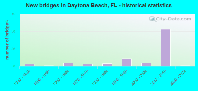
- New bridges - historical statistics
- 31940-1949
- 11950-1959
- 51960-1969
- 31970-1979
- 41980-1989
- 111990-1999
- 52000-2009
- 532010-2019
- 12020-2022

- Reconstructed bridges - Historical Statistics
- 11960-1969
- 01970-1979
- 01980-1989
- 11990-1999
- 12000-2009
- 12010-2019


- Bridge Condition - Deck
- 11.4%Excellent
- 48.6%Very good
- 31.4%Good
- 2.9%Satisfactory
- 5.7%Fair

- Bridge Condition - Superstructure
- 25.7%Very good
- 65.7%Good
- 2.9%Satisfactory
- 5.7%Fair

- Bridge Condition - Substructure
- 25.7%Excellent
- 37.1%Very good
- 28.6%Good
- 5.7%Satisfactory
- 2.9%Fair

- Bridge Condition - Channel
- 4.0%Very good
- 48.0%Good
- 48.0%Satisfactory

- Bridge Condition - Culverts
- 42.9%Good
- 50.0%Satisfactory
- 7.1%Fair
Find on map >> Show street view
Structure Number: 794038, Location: 0.4 Mile West of I-95 (Lat: 29.217208, Lng: -81.109453), Route carried "on" structure: County highway , Year Built: 1968, Status: Open, Structure Length: 7.63m (25.03ft), Average Daily Traffic: 10,300 (year 2020), Truck Traffic: 10%, Average Future Daily Traffic: 17,871 (year 2042), Design Load: HS 20, Features Intersected: Tomoka River, Facility Carried by Structure: LPGA Blvd
Minimum Vertical Clearance: 30+ m (98+ ft), Kilometerpoint: 8.124, Lanes on structure: 2, Owner: County Highway Agency, Approaching Roadway Width: 8.6m (28.2ft), Material/Design: Prestressed concrete, Design/Construction: Stringer/Multi-beam, Number Of Spans In Main Unit: 5, Length of Maximum Span: 15.3m (50.2ft), Curb or Sidewalk Widths: Left: 0.5m (1.6ft), Right: 0.5m (1.6ft), Curb-To-Curb Width: 8.5m (27.9ft), Out-to-Out Width: 10.0m (32.8ft)
Condition: Deck: Good, Superstructure: Good, Substructure: Good, Channel: Satisfactory, Operating Rating: 71.6 metric tons, Method Used To Determine Operating Rating: Load Factor (LF), Inventory Rating: 44.5 metric tons, Method Used To Determine Inventory Rating: Load Factor (LF), Structural Evaluation: Better than present minimum criteria, Deck Geometry: Meets minimum limits, Waterway Adequacy: Equal to present desirable criteria, Approach Roadway Alignment: Equal to present desirable criteria, Designated Inspection Frequency: Every 24 months, Underwater Inspection Frequency: Every 24 months, Inspection Date: April 2020, Underwater Inspection Date: April 2020, Deck Structure Type: Concrete Cast-file-Place
Find on map >> Show street view
Structure Number: 794042, Location: 0.1Mi S of LPGA Blvd (Lat: 29.245989, Lng: -81.036514), Route carried "on" structure: County highway , Year Built: 1970, Status: Open, Structure Length: 0.96m (3.15ft), Average Daily Traffic: 6,700 (year 2020), Truck Traffic: 5%, Average Future Daily Traffic: 11,625 (year 2042), Design Load: HS 20, Features Intersected: Halifax Canal, Facility Carried by Structure: Riverside Dr
Minimum Vertical Clearance: 30+ m (98+ ft), Kilometerpoint: 2.182, Lanes on structure: 2, Owner: City or Municipal Highway Agency, Approaching Roadway Width: 6.7m (22.0ft), Material/Design: Concrete, Design/Construction: Culvert, Number Of Spans In Main Unit: 3, Length of Maximum Span: 3.0m (9.8ft)
Condition: Channel: Good, Culverts: Satisfactory, Operating Rating: 58.4 metric tons, Method Used To Determine Operating Rating: Load Factor (LF), Inventory Rating: 35.1 metric tons, Method Used To Determine Inventory Rating: Load Factor (LF), Structural Evaluation: Equal to present minimum criteria, Waterway Adequacy: Equal to present desirable criteria, Approach Roadway Alignment: Equal to present desirable criteria, Designated Inspection Frequency: Every 24 months, Underwater Inspection Frequency: Every 24 months, Inspection Date: April 2020, Underwater Inspection Date: April 2020
Find on map >> Show street view
Structure Number: 794096, Location: 1.4 miles North of US-92 (Lat: 29.214928, Lng: -81.090986), Route carried "on" structure: City street , Year Built: 1994, Status: Open, Structure Length: 1.24m (4.07ft), Average Daily Traffic: 22,500 (year 2020), Truck Traffic: 2%, Average Future Daily Traffic: 39,038 (year 2042), Design Load: HS 20, Features Intersected: 11th Street Canal, Facility Carried by Structure: Williamson Blvd
Minimum Vertical Clearance: 30+ m (98+ ft), Kilometerpoint: 0.016, Lanes on structure: 4, Owner: County Highway Agency, Approaching Roadway Width: 23.9m (78.4ft), Skew: 4 degrees, Material/Design: Concrete, Design/Construction: Culvert, Number Of Spans In Main Unit: 3, Length of Maximum Span: 3.7m (12.1ft)
Condition: Channel: Satisfactory, Culverts: Satisfactory, Structural Evaluation: Equal to present minimum criteria, Waterway Adequacy: Equal to present desirable criteria, Approach Roadway Alignment: Equal to present desirable criteria, Designated Inspection Frequency: Every 24 months, Underwater Inspection Frequency: Every 24 months, Inspection Date: April 2020, Underwater Inspection Date: April 2020
Find on map >> Show street view
Structure Number: 79412, Location: 0.25 Mi E of US-1 SR-5 (Lat: 29.208672, Lng: -81.016683), Route carried "on" structure: County highway , Year Built: 1989, Status: Open, Structure Length: 5.04m (16.54ft), Average Daily Traffic: 7,900 (year 2020), Truck Traffic: 5%, Average Future Daily Traffic: 13,707 (year 2042), Design Load: HS 20, Features Intersected: Halifax River, Facility Carried by Structure: Orange Avenue
Minimum Vertical Clearance: 30+ m (98+ ft), Kilometerpoint: 2.250, Lanes on structure: 4, Owner: County Highway Agency, Approaching Roadway Width: 20.3m (66.6ft), Material/Design: Concrete continuous, Design/Construction: Slab, Number Of Spans In Main Unit: 5, Length of Maximum Span: 10.5m (34.4ft), Curb or Sidewalk Widths: Left: 2.1m (6.9ft), Right: 2.1m (6.9ft), Curb-To-Curb Width: 20.3m (66.6ft), Out-to-Out Width: 25.5m (83.7ft)
Condition: Deck: Good, Superstructure: Good, Substructure: Good, Channel: Good, Operating Rating: 60.9 metric tons, Method Used To Determine Operating Rating: Load Factor (LF), Inventory Rating: 36.6 metric tons, Method Used To Determine Inventory Rating: Load Factor (LF), Structural Evaluation: Better than present minimum criteria, Deck Geometry: Equal to present desirable criteria, Waterway Adequacy: Superior to present desirable criteria, Approach Roadway Alignment: Equal to present desirable criteria, Designated Inspection Frequency: Every 24 months, Underwater Inspection Frequency: Every 24 months, Inspection Date: April 2020, Underwater Inspection Date: April 2020, Deck Structure Type: Concrete Cast-file-Place
Find on map >> Show street view
Structure Number: 794189, Location: 2.0 MI N of US-92 on I-95 (Lat: 29.197983, Lng: -81.095794), Route carried "on" structure: County highway , Year Built: 2011, Status: Open, Structure Length: 13.38m (43.90ft), Average Daily Traffic: 4,900 (year 2020), Truck Traffic: 9%, Average Future Daily Traffic: 8,502 (year 2042), Design Load: HL 93, Features Intersected: I-95, Facility Carried by Structure: Dunn Avenue
Minimum Vertical Clearance: 30+ m (98+ ft), Kilometerpoint: 0.327, Lanes on structure: 2, Lanes under structure: 8, Owner: County Highway Agency, Approaching Roadway Width: 10.2m (33.5ft), Skew: 5 degrees, Material/Design: Prestressed concrete, Design/Construction: Stringer/Multi-beam, Number Of Spans In Main Unit: 4, Length of Maximum Span: 37.5m (123.0ft), Curb or Sidewalk Widths: Left: 2.4m (7.9ft), Right: 0.0m, Curb-To-Curb Width: 13.4m (44.0ft), Out-to-Out Width: 17.1m (56.1ft)
Condition: Deck: Very good, Superstructure: Very good, Substructure: Very good, Operating Rating: 55.5 metric tons, Method Used To Determine Operating Rating: Load and Resistance Factor (LRFR), Inventory Rating: 42.8 metric tons, Method Used To Determine Inventory Rating: Load and Resistance Factor (LRFR), Structural Evaluation: Equal to present desirable criteria, Deck Geometry: Better than present minimum criteria, Underclear: Equal to present minimum criteria, Approach Roadway Alignment: Equal to present desirable criteria, Designated Inspection Frequency: Every 24 months, Inspection Date: July 2021, Deck Structure Type: Concrete Cast-file-Place
Find on map >> Show street view
Structure Number: 794198, Location: 0.4Mi. West of SR-A1A (Lat: 29.211125, Lng: -81.011131), Route carried "on" structure: County highway 4050, Year Built: 2020, Status: Open, Structure Length: 57.45m (188.48ft), Average Daily Traffic: 7,900 (year 2020), Truck Traffic: 4%, Average Future Daily Traffic: 13,706 (year 2042), Design Load: HL 93, Features Intersected: Halifax River
Minimum Vertical Clearance: 30+ m (98+ ft), Kilometerpoint: 2.763, Lanes on structure: 2, Owner: County Highway Agency, Approaching Roadway Width: 9.8m (32.2ft), Navigation Control: Yes ( Vertical Clearance: 19.8m (65.0ft), Horizontal Clearance: 38.1m (125.0ft)), Material/Design: Concrete, Design/Construction: Arch - Thru, Number Of Spans In Main Unit: 1, Number Of Approach Spans: 14, Length of Maximum Span: 67.4m (221.1ft), Curb or Sidewalk Widths: Left: 2.4m (7.9ft), Right: 2.4m (7.9ft), Curb-To-Curb Width: 9.8m (32.2ft), Out-to-Out Width: 16.2m (53.1ft)
Condition: Deck: Very good, Superstructure: Good, Substructure: Very good, Channel: Good, Operating Rating: 42.1 metric tons, Method Used To Determine Operating Rating: Load and Resistance Factor (LRFR), Inventory Rating: 33.3 metric tons, Method Used To Determine Inventory Rating: Load and Resistance Factor (LRFR), Structural Evaluation: Better than present minimum criteria, Deck Geometry: Meets minimum limits, Waterway Adequacy: Equal to present desirable criteria, Approach Roadway Alignment: Equal to present desirable criteria, Designated Inspection Frequency: Every 23 months, Underwater Inspection Frequency: Every 23 months, Inspection Date: May 2020, Underwater Inspection Date: May 2020, Deck Structure Type: Concrete Cast-file-Place
Find on map >> Show street view
Structure Number: 795001, Location: 10ft. East of Nova Road (Lat: 29.183861, Lng: -81.029692), Route carried "on" structure: City street , Year Built: 1986, Status: Open, Structure Length: 0.74m (2.43ft), Average Daily Traffic: 1,082 (year 2020), Truck Traffic: 5%, Average Future Daily Traffic: 1,878 (year 2042), Design Load: H 10, Features Intersected: Nova Canal, Facility Carried by Structure: Woodcliff Drive
Minimum Vertical Clearance: 30+ m (98+ ft), Kilometerpoint: 0.024, Lanes on structure: 2, Owner: City or Municipal Highway Agency, Approaching Roadway Width: 7.9m (25.9ft), Skew: 1 degrees, Material/Design: Concrete, Design/Construction: Culvert, Number Of Spans In Main Unit: 2, Length of Maximum Span: 3.0m (9.8ft)
Condition: Channel: Satisfactory, Culverts: Good, Operating Rating: 35.9 metric tons, Method Used To Determine Operating Rating: Load Factor (LF), Inventory Rating: 21.6 metric tons, Method Used To Determine Inventory Rating: Load Factor (LF), Structural Evaluation: Somewhat better than minimum adequacy, Waterway Adequacy: Equal to present desirable criteria, Approach Roadway Alignment: Equal to present desirable criteria, Designated Inspection Frequency: Every 24 months, Underwater Inspection Frequency: Every 24 months, Inspection Date: May 2020, Underwater Inspection Date: May 2020
Find on map >> Show street view
Structure Number: 790171, Location: LPGA Blvd. at I-95 (Lat: 29.219964, Lng: -81.103117), Route carried "under" structure: Interstate 95, Year Built: 1995, Structure Length: 0. m, Average Daily Traffic: 74,500 (year 2020), Truck Traffic: 18%, Features Intersected: I-95, Facility Carried by Structure: LPGA Blvd
Minimum Vertical Clearance: 5.00m (16.40ft), Kilometerpoint: 52.444, Lanes on structure: 6, Lanes under structure: 8, Material/Design: Prestressed concrete, Design/Construction: Stringer/Multi-beam, Length of Maximum Span: 33.9m (111.2ft)
Find on map >> Show street view
Structure Number: 790174, Location: SR-430 WB - Halifax River (Lat: 29.231194, Lng: -81.022419), Route carried "under" structure: Business City street , Year Built: 1997, Structure Length: 0. m, Average Daily Traffic: 100 (year 2002), Truck Traffic: 1%, Features Intersected: IWW Halifax River, Facility Carried by Structure: SR-430 WB
Minimum Vertical Clearance: 4.51m (14.80ft), Kilometerpoint: 0.002, Lanes on structure: 2, Lanes under structure: 2, Material/Design: Prestressed concrete continuous, Design/Construction: Segmental Box Girder, Length of Maximum Span: 75.3m (247.0ft)
Find on map >> Show street view
Structure Number: 790174, Location: SR-430 WB - Halifax River (Lat: 29.231194, Lng: -81.022419), Route carried "under" structure: Business City street , Year Built: 1997, Structure Length: 0. m, Average Daily Traffic: 4,100 (year 2020), Truck Traffic: 5%, Features Intersected: IWW Halifax River, Facility Carried by Structure: SR-430 WB
Minimum Vertical Clearance: 6.46m (21.19ft), Kilometerpoint: 2.496, Lanes on structure: 2, Lanes under structure: 2, Material/Design: Prestressed concrete continuous, Design/Construction: Segmental Box Girder, Length of Maximum Span: 75.3m (247.0ft)
Find on map >> Show street view
Structure Number: 790175, Location: SR-430 EB - Halifax River (Lat: 29.230319, Lng: -81.021817), Route carried "under" structure: Business City street , Year Built: 1997, Structure Length: 0. m, Average Daily Traffic: 4,100 (year 2020), Truck Traffic: 5%, Features Intersected: IWW Halifax River, Facility Carried by Structure: SR-430 EB
Minimum Vertical Clearance: 6.55m (21.49ft), Kilometerpoint: 2.464, Lanes on structure: 2, Lanes under structure: 2, Material/Design: Prestressed concrete continuous, Design/Construction: Segmental Box Girder, Length of Maximum Span: 75.3m (247.0ft)
Find on map >> Show street view
Structure Number: 790192, Location: I-4/I-95 Intchg (Lat: 29.155736, Lng: -81.075828), Route carried "under" structure: Ramp Interstate , Year Built: 2019, Structure Length: 0. m, Average Daily Traffic: 2,450 (year 2020), Truck Traffic: 9%, Features Intersected: I-95, Facility Carried by Structure: I-4 WB
Minimum Vertical Clearance: 7.28m (23.88ft), Kilometerpoint: 2.873, Lanes on structure: 4, Lanes under structure: 2, Material/Design: Prestressed concrete, Design/Construction: Stringer/Multi-beam, Length of Maximum Span: 41.3m (135.5ft)
Find on map >> Show street view
Structure Number: 790192, Location: I-4/I-95 Intchg (Lat: 29.155736, Lng: -81.075828), Route carried "under" structure: Ramp Interstate , Year Built: 2019, Structure Length: 0. m, Average Daily Traffic: 2,450 (year 2020), Truck Traffic: 9%, Features Intersected: I-95, Facility Carried by Structure: I-4 WB
Minimum Vertical Clearance: 18.17m (59.61ft), Kilometerpoint: 0.410, Lanes on structure: 4, Lanes under structure: 2, Material/Design: Prestressed concrete, Design/Construction: Stringer/Multi-beam, Length of Maximum Span: 41.3m (135.5ft)
Find on map >> Show street view
Structure Number: 790192, Location: I-4/I-95 Intchg (Lat: 29.155736, Lng: -81.075828), Route carried "under" structure: Interstate 95, Year Built: 2019, Structure Length: 0. m, Average Daily Traffic: 74,500 (year 2020), Truck Traffic: 17%, Features Intersected: I-95, Facility Carried by Structure: I-4 WB
Minimum Vertical Clearance: 6.52m (21.39ft), Kilometerpoint: 43.549, Lanes on structure: 4, Lanes under structure: 6, Material/Design: Prestressed concrete, Design/Construction: Stringer/Multi-beam, Length of Maximum Span: 41.3m (135.5ft)
Find on map >> Show street view
Structure Number: 790208, Location: I-4 EB Ramp A to US-92 (Lat: 29.136944, Lng: -81.118611), Route carried "under" structure: Interstate 4, Year Built: 2015, Structure Length: 0. m, Average Daily Traffic: 25,500 (year 2020), Truck Traffic: 19%, Features Intersected: I-4
Minimum Vertical Clearance: 7.86m (25.79ft), Kilometerpoint: 39.939, Lanes on structure: 2, Lanes under structure: 6, Material/Design: Prestressed concrete, Design/Construction: Stringer/Multi-beam, Length of Maximum Span: 49.1m (161.1ft)
Find on map >> Show street view
Structure Number: 79023, Location: I-4/I-95 Interchange (Lat: 29.155083, Lng: -81.075472), Route carried "under" structure: Interstate 95, Year Built: 2018, Structure Length: 0. m, Average Daily Traffic: 74,500 (year 2020), Truck Traffic: 18%, Features Intersected: I-95, Facility Carried by Structure: I-4 Eastbound
Minimum Vertical Clearance: 5.79m (19.00ft), Kilometerpoint: 44.820, Lanes on structure: 3, Lanes under structure: 6, Material/Design: Prestressed concrete, Design/Construction: Stringer/Multi-beam, Length of Maximum Span: 40.0m (131.2ft)
Find on map >> Show street view
Structure Number: 79023, Location: I-4/I-95 Interchange (Lat: 29.155083, Lng: -81.075472), Route carried "under" structure: Ramp Interstate 95, Year Built: 2018, Structure Length: 0. m, Average Daily Traffic: 2,450 (year 2020), Truck Traffic: 9%, Features Intersected: I-95, Facility Carried by Structure: I-4 Eastbound
Minimum Vertical Clearance: 6.98m (22.90ft), Kilometerpoint: 2.953, Lanes on structure: 3, Lanes under structure: 2, Material/Design: Prestressed concrete, Design/Construction: Stringer/Multi-beam, Length of Maximum Span: 40.0m (131.2ft)
Find on map >> Show street view
Structure Number: 79023, Location: I-4/I-95 Interchange (Lat: 29.155083, Lng: -81.075472), Route carried "under" structure: Ramp Interstate 95, Year Built: 2018, Structure Length: 0. m, Average Daily Traffic: 2,450 (year 2020), Truck Traffic: 9%, Features Intersected: I-95, Facility Carried by Structure: I-4 Eastbound
Minimum Vertical Clearance: 5.79m (19.00ft), Kilometerpoint: 0.335, Lanes on structure: 3, Lanes under structure: 2, Material/Design: Prestressed concrete, Design/Construction: Stringer/Multi-beam, Length of Maximum Span: 40.0m (131.2ft)
Find on map >> Show street view
Structure Number: 790231, Location: I-4/I-95 Interchange (Lat: 29.157258, Lng: -81.076758), Route carried "under" structure: Interstate 95, Year Built: 2017, Structure Length: 0. m, Average Daily Traffic: 74,500 (year 2020), Truck Traffic: 18%, Features Intersected: I-95
Minimum Vertical Clearance: 5.36m (17.59ft), Kilometerpoint: 45.123, Lanes on structure: 2, Lanes under structure: 6, Material/Design: Prestressed concrete, Design/Construction: Stringer/Multi-beam, Length of Maximum Span: 51.5m (169.0ft)
Find on map >> Show street view
Structure Number: 790231, Location: I-4/I-95 Interchange (Lat: 29.157258, Lng: -81.076758), Route carried "under" structure: Ramp Interstate 95, Year Built: 2017, Structure Length: 0. m, Average Daily Traffic: 2,450 (year 2020), Truck Traffic: 9%, Features Intersected: I-95
Minimum Vertical Clearance: 5.43m (17.81ft), Kilometerpoint: 2.375, Lanes on structure: 2, Lanes under structure: 2, Material/Design: Prestressed concrete, Design/Construction: Stringer/Multi-beam, Length of Maximum Span: 51.5m (169.0ft)
Find on map >> Show street view
Structure Number: 790232, Location: I-4/I-95 Interchange (Lat: 29.154778, Lng: -81.078528), Route carried "under" structure: Ramp Interstate 4, Year Built: 2018, Structure Length: 0. m, Average Daily Traffic: 15,500 (year 2020), Truck Traffic: 21%, Features Intersected: I-4 WB, Facility Carried by Structure: Ramp AC
Minimum Vertical Clearance: 5.30m (17.39ft), Kilometerpoint: 0.225, Lanes on structure: 2, Lanes under structure: 2, Material/Design: Prestressed concrete, Design/Construction: Stringer/Multi-beam, Length of Maximum Span: 54.0m (177.2ft)
Find on map >> Show street view
Structure Number: 790233, Location: I-4/I-95 Interchange (Lat: 29.154056, Lng: -81.077583), Route carried "under" structure: Ramp Interstate 95, Year Built: 2018, Structure Length: 0. m, Average Daily Traffic: 3,000 (year 2020), Truck Traffic: 18%, Features Intersected: Ramp F2 & Ramp H1, Facility Carried by Structure: I-4 Eastbound
Minimum Vertical Clearance: 6.28m (20.60ft), Kilometerpoint: 0.193, Lanes on structure: 2, Lanes under structure: 1, Material/Design: Prestressed concrete, Design/Construction: Stringer/Multi-beam, Length of Maximum Span: 50.0m (164.0ft)
Find on map >> Show street view
Structure Number: 790233, Location: I-4/I-95 Interchange (Lat: 29.154056, Lng: -81.077583), Route carried "under" structure: Ramp Interstate 95, Year Built: 2018, Structure Length: 0. m, Average Daily Traffic: 2,000 (year 2020), Truck Traffic: 18%, Features Intersected: Ramp F2 & Ramp H1, Facility Carried by Structure: I-4 Eastbound
Minimum Vertical Clearance: 5.21m (17.09ft), Kilometerpoint: 44.339, Lanes on structure: 2, Lanes under structure: 1, Material/Design: Prestressed concrete, Design/Construction: Stringer/Multi-beam, Length of Maximum Span: 50.0m (164.0ft)
Find on map >> Show street view
Structure Number: 790234, Location: I-95 SB over US-92 (Lat: 29.171825, Lng: -81.084514), Route carried "under" structure: US 92, Year Built: 2017, Structure Length: 0. m, Average Daily Traffic: 30,000 (year 2020), Truck Traffic: 5%, Features Intersected: US-92, Facility Carried by Structure: I-95 SB
Minimum Vertical Clearance: 7.53m (24.70ft), Kilometerpoint: 25.606, Lanes on structure: 3, Lanes under structure: 7, Material/Design: Prestressed concrete, Design/Construction: Stringer/Multi-beam, Length of Maximum Span: 45.8m (150.3ft)
Find on map >> Show street view
Structure Number: 790235, Location: I-95 NB over US-92 (Lat: 29.171997, Lng: -81.084339), Route carried "under" structure: US 92, Year Built: 2018, Structure Length: 0. m, Average Daily Traffic: 30,000 (year 2020), Truck Traffic: 5%, Features Intersected: US-92, Facility Carried by Structure: I-95 NB
Minimum Vertical Clearance: 7.62m (25.00ft), Kilometerpoint: 25.629, Lanes on structure: 3, Lanes under structure: 7, Material/Design: Prestressed concrete, Design/Construction: Stringer/Multi-beam, Length of Maximum Span: 45.4m (149.0ft)
Find on map >> Show street view
Structure Number: 790236, Location: I-95 SBCD over US-92 (Lat: 29.171653, Lng: -81.084611), Route carried "under" structure: US 92, Year Built: 2017, Structure Length: 0. m, Average Daily Traffic: 30,000 (year 2020), Truck Traffic: 5%, Features Intersected: US-92, Facility Carried by Structure: I-95 SBCD
Minimum Vertical Clearance: 7.92m (25.98ft), Kilometerpoint: 25.595, Lanes on structure: 2, Lanes under structure: 7, Material/Design: Prestressed concrete, Design/Construction: Stringer/Multi-beam, Length of Maximum Span: 46.3m (151.9ft)
Find on map >> Show street view
Structure Number: 790237, Location: I-95 NB over US-92 (Lat: 29.172225, Lng: -81.084269), Route carried "under" structure: US 92, Year Built: 2018, Structure Length: 0. m, Average Daily Traffic: 30,000 (year 2020), Truck Traffic: 5%, Features Intersected: US-92, Facility Carried by Structure: I-95 NB
Minimum Vertical Clearance: 7.65m (25.10ft), Kilometerpoint: 25.647, Lanes on structure: 3, Lanes under structure: 7, Material/Design: Prestressed concrete, Design/Construction: Stringer/Multi-beam, Length of Maximum Span: 45.9m (150.6ft)
Find on map >> Show street view
Structure Number: 790238, Location: I-95/US-92 Interchange (Lat: 29.171389, Lng: -81.084761), Route carried "under" structure: US 92, Year Built: 2018, Structure Length: 0. m, Average Daily Traffic: 5,700 (year 2018), Truck Traffic: 18%, Features Intersected: I-95 & US-92, Facility Carried by Structure: Ramp J2 & K2
Minimum Vertical Clearance: 7.59m (24.90ft), Kilometerpoint: 0.000, Lanes on structure: 2, Lanes under structure: 7, Material/Design: Prestressed concrete, Design/Construction: Stringer/Multi-beam, Length of Maximum Span: 41.9m (137.5ft)
Find on map >> Show street view
Structure Number: 790239, Location: I95NB over I95SB On Ramp (Lat: 29.173644, Lng: -81.085181), Route carried "under" structure: Ramp US 92, Year Built: 2018, Structure Length: 0. m, Average Daily Traffic: 6,100 (year 2020), Truck Traffic: 5%, Features Intersected: Ramp J2, Facility Carried by Structure: I-95 NB CD
Minimum Vertical Clearance: 7.50m (24.61ft), Kilometerpoint: 0.153, Lanes on structure: 3, Lanes under structure: 1, Material/Design: Prestressed concrete, Design/Construction: Stringer/Multi-beam, Length of Maximum Span: 20.4m (66.9ft)
Find on map >> Show street view
Structure Number: 79024, Location: Tomoka Farms Rd over I-4 (Lat: 29.152222, Lng: -81.082778), Route carried "under" structure: Interstate 4, Year Built: 2018, Structure Length: 0. m, Average Daily Traffic: 51,000 (year 2020), Truck Traffic: 19%, Features Intersected: I-4, Facility Carried by Structure: Tomoka Farms Road
Minimum Vertical Clearance: 7.28m (23.88ft), Kilometerpoint: 43.830, Lanes on structure: 2, Lanes under structure: 9, Material/Design: Prestressed concrete, Design/Construction: Stringer/Multi-beam, Length of Maximum Span: 39.9m (130.9ft)
Find on map >> Show street view
Structure Number: 790241, Location: Bellevue Avenue over I-95 (Lat: 29.167778, Lng: -81.082778), Route carried "under" structure: Ramp Interstate 95, Year Built: 2016, Structure Length: 0. m, Average Daily Traffic: 2,450 (year 2020), Truck Traffic: 9%, Features Intersected: I-95, Facility Carried by Structure: Bellevue Avenue
Minimum Vertical Clearance: 7.25m (23.79ft), Kilometerpoint: 1.933, Lanes on structure: 2, Lanes under structure: 3, Material/Design: Prestressed concrete, Design/Construction: Stringer/Multi-beam, Length of Maximum Span: 44.9m (147.3ft)
Find on map >> Show street view
Structure Number: 790241, Location: Bellevue Avenue over I-95 (Lat: 29.167778, Lng: -81.082778), Route carried "under" structure: Ramp Interstate 95, Year Built: 2016, Structure Length: 0. m, Average Daily Traffic: 2,450 (year 2020), Truck Traffic: 9%, Features Intersected: I-95, Facility Carried by Structure: Bellevue Avenue
Minimum Vertical Clearance: 7.44m (24.41ft), Kilometerpoint: 1.363, Lanes on structure: 2, Lanes under structure: 3, Material/Design: Prestressed concrete, Design/Construction: Stringer/Multi-beam, Length of Maximum Span: 44.9m (147.3ft)
Find on map >> Show street view
Structure Number: 790241, Location: Bellevue Avenue over I-95 (Lat: 29.167778, Lng: -81.082778), Route carried "under" structure: Interstate 95, Year Built: 2016, Structure Length: 0. m, Average Daily Traffic: 74,500 (year 2020), Truck Traffic: 18%, Features Intersected: I-95, Facility Carried by Structure: Bellevue Avenue
Minimum Vertical Clearance: 5.76m (18.90ft), Kilometerpoint: 46.347, Lanes on structure: 2, Lanes under structure: 6, Material/Design: Prestressed concrete, Design/Construction: Stringer/Multi-beam, Length of Maximum Span: 44.9m (147.3ft)
Find on map >> Show street view
Structure Number: 790244, Location: I95SB over I95SB On Ramp (Lat: 29.173194, Lng: -81.085569), Route carried "under" structure: Ramp US 92, Year Built: 2017, Structure Length: 0. m, Average Daily Traffic: 6,100 (year 2020), Truck Traffic: 5%, Features Intersected: Ramp J2, Facility Carried by Structure: I-95 SBCD
Minimum Vertical Clearance: 6.95m (22.80ft), Kilometerpoint: 0.214, Lanes on structure: 2, Lanes under structure: 1, Material/Design: Prestressed concrete, Design/Construction: Stringer/Multi-beam, Length of Maximum Span: 26.1m (85.6ft)
Find on map >> Show street view
Structure Number: 790248, Location: I-4 Connector over US-92 (Lat: 29.144431, Lng: -81.118278), Route carried "under" structure: Interstate 92, Year Built: 2013, Structure Length: 0. m, Average Daily Traffic: 18,900 (year 2020), Truck Traffic: 7%, Features Intersected: US 92, Facility Carried by Structure: I-4 Ramp B
Minimum Vertical Clearance: 6.61m (21.69ft), Kilometerpoint: 21.127, Lanes on structure: 2, Lanes under structure: 4, Material/Design: Prestressed concrete, Design/Construction: Stringer/Multi-beam, Length of Maximum Span: 55.6m (182.4ft)
Find on map >> Show street view
Structure Number: 790252, Location: I95SB over I95SB On Ramp (Lat: 29.173342, Lng: -81.085500), Route carried "under" structure: Ramp US 92, Year Built: 2017, Structure Length: 0. m, Average Daily Traffic: 6,100 (year 2020), Truck Traffic: 5%, Features Intersected: Ramp J2, Facility Carried by Structure: I-95 SB
Minimum Vertical Clearance: 7.41m (24.31ft), Kilometerpoint: 0.192, Lanes on structure: 3, Lanes under structure: 1, Material/Design: Prestressed concrete, Design/Construction: Stringer/Multi-beam, Length of Maximum Span: 24.4m (80.1ft)
Find on map >> Show street view
Structure Number: 790253, Location: I-95NB over I-95SB OnRamp (Lat: 29.173528, Lng: -81.085333), Route carried "under" structure: Ramp US 92, Year Built: 2017, Structure Length: 0. m, Average Daily Traffic: 6,100 (year 2020), Truck Traffic: 18%, Features Intersected: Ramp J2, Facility Carried by Structure: I-95 NB
Minimum Vertical Clearance: 7.44m (24.41ft), Kilometerpoint: 0.169, Lanes on structure: 3, Lanes under structure: 1, Material/Design: Prestressed concrete, Design/Construction: Stringer/Multi-beam, Length of Maximum Span: 20.4m (66.9ft)
Find on map >> Show street view
Structure Number: 794097, Location: 0.5 mile South of US-92 (Lat: 29.190972, Lng: -81.049139), Route carried "under" structure: State highway 483, Year Built: 1998, Structure Length: 0. m, Average Daily Traffic: 32,000 (year 2020), Truck Traffic: 5%, Features Intersected: Clyde Morris Blvd., Facility Carried by Structure: Pedestrian Ovrpass
Minimum Vertical Clearance: 5.36m (17.59ft), Kilometerpoint: 2.620, Lanes under structure: 4, Material/Design: Prestressed concrete, Design/Construction: Stringer/Multi-beam, Length of Maximum Span: 219.5m (720.1ft)
Find on map >> Show street view
Structure Number: 794187, Location: Ocean Walk Ped Br - AIA (Lat: 29.231111, Lng: -81.010833), Route carried "under" structure: State highway A1A, Year Built: 2002, Structure Length: 0. m, Average Daily Traffic: 26,000 (year 2020), Truck Traffic: 6%, Features Intersected: SR-A1A, Facility Carried by Structure: Pedestrian Bridge
Minimum Vertical Clearance: 5.55m (18.21ft), Kilometerpoint: 3.376, Lanes under structure: 4, Material/Design: Steel, Design/Construction: Truss - Thru, Length of Maximum Span: 28.0m (91.9ft)
Find on map >> Show street view
Structure Number: 794189, Location: 2.0 MI N of US-92 on I-95 (Lat: 29.197983, Lng: -81.095794), Route carried "under" structure: Interstate 5, Year Built: 2011, Structure Length: 0. m, Average Daily Traffic: 74,500 (year 2020), Truck Traffic: 18%, Features Intersected: I-95, Facility Carried by Structure: Dunn Avenue
Minimum Vertical Clearance: 5.06m (16.60ft), Kilometerpoint: 50.043, Lanes on structure: 2, Lanes under structure: 6, Material/Design: Prestressed concrete, Design/Construction: Stringer/Multi-beam, Length of Maximum Span: 37.5m (123.0ft)
Find on map >> Show street view
Structure Number: 794189, Location: 2.0 MI N of US-92 on I-95 (Lat: 29.197983, Lng: -81.095794), Route carried "under" structure: County highway , Year Built: 2011, Structure Length: 0. m, Average Daily Traffic: 9,900 (year 2020), Truck Traffic: 9%, Features Intersected: I-95, Facility Carried by Structure: Dunn Avenue
Minimum Vertical Clearance: 5.18m (16.99ft), Kilometerpoint: 3.508, Lanes on structure: 2, Lanes under structure: 2, Material/Design: Prestressed concrete, Design/Construction: Stringer/Multi-beam, Length of Maximum Span: 37.5m (123.0ft)
Find on map >> Show street view
Structure Number: 79509, Location: 500ft W of Indust Pkwy (Lat: 29.191083, Lng: -81.072028), Route carried "under" structure: US 92, Year Built: 2001, Structure Length: 0. m, Average Daily Traffic: 43,760 (year 2020), Truck Traffic: 5%, Features Intersected: US-92 Int Spdwy Bl, Facility Carried by Structure: Pedestrian Overpas
Minimum Vertical Clearance: 5.46m (17.91ft), Kilometerpoint: 28.147, Lanes under structure: 8, Material/Design: Steel, Design/Construction: Truss - Thru, Length of Maximum Span: 64.0m (210.0ft)
Find on map >> Show street view
Structure Number: 795091, Location: 750' W Bill France Blvd (Lat: 29.192214, Lng: -81.069042), Route carried "under" structure: ServiceOther road , Year Built: 2015, Structure Length: 0. m, Average Daily Traffic: 20 (year 2018), Features Intersected: US-92 Int Speedway Blvd, Facility Carried by Structure: Pedestrian Overpas
Minimum Vertical Clearance: 5.70m (18.70ft), Kilometerpoint: 0.000, Lanes under structure: 2, Material/Design: Steel, Design/Construction: Truss - Thru, Length of Maximum Span: 55.5m (182.1ft)
Find on map >> Show street view
Structure Number: 795091, Location: 750' W Bill France Blvd (Lat: 29.192214, Lng: -81.069042), Route carried "under" structure: US 92, Year Built: 2015, Structure Length: 0. m, Average Daily Traffic: 45,000 (year 2020), Truck Traffic: 6%, Features Intersected: US-92 Int Speedway Blvd, Facility Carried by Structure: Pedestrian Overpas
Minimum Vertical Clearance: 5.82m (19.09ft), Kilometerpoint: 28.469, Lanes under structure: 8, Material/Design: Steel, Design/Construction: Truss - Thru, Length of Maximum Span: 55.5m (182.1ft)