Bridge Statistics for Delano, California (CA)
Condition, Traffic, Stress, Structural Evaluation, Project Costs
- National Bridge Inventory (NBI) Statistics
- 23Number of bridges
- 269ft / 82.2mTotal length
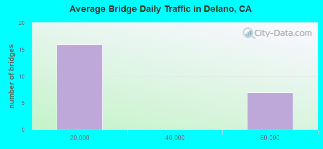
- 445,452Total average daily traffic
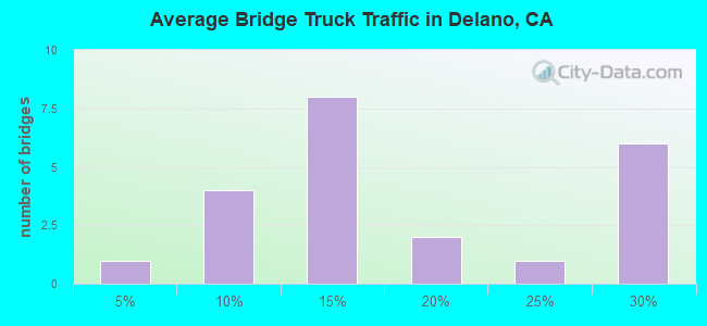
- 95,300Total average daily truck traffic
- National Bridge Inventory (NBI) Registered Bridges for Delano
- No street view available for this location
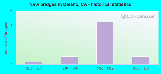
- New bridges - historical statistics
- 11930-1939
- 31940-1949
- 161950-1959
- 31960-1969
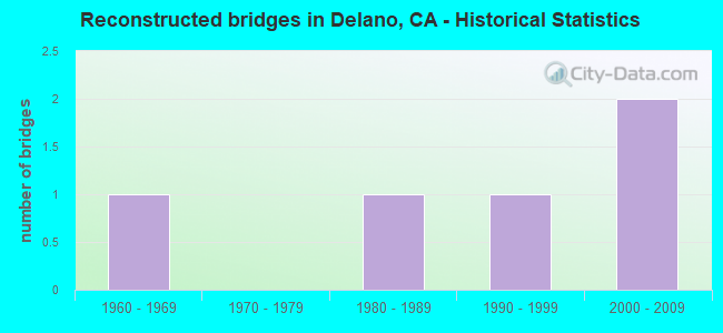
- Reconstructed bridges - Historical Statistics
- 11960-1969
- 01970-1979
- 11980-1989
- 11990-1999
- 22000-2009
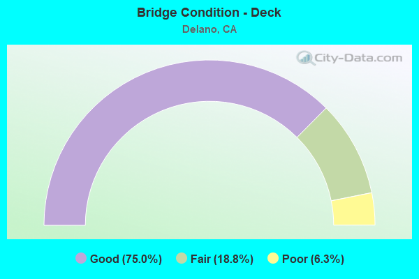
- Bridge Condition - Deck
- 75.0%Good
- 18.8%Fair
- 6.3%Poor
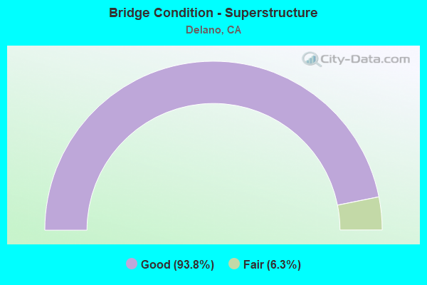
- Bridge Condition - Superstructure
- 93.8%Good
- 6.3%Fair
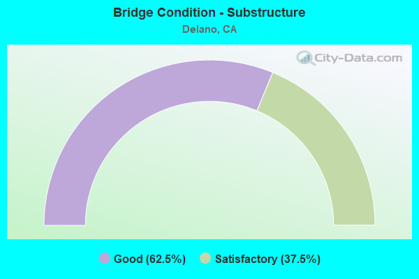
- Bridge Condition - Substructure
- 62.5%Good
- 37.5%Satisfactory
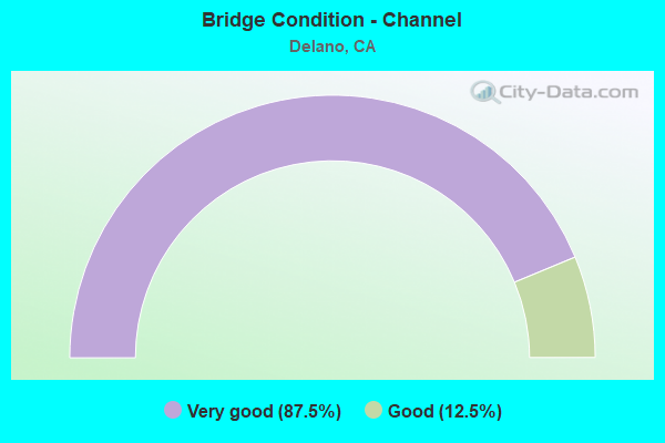
- Bridge Condition - Channel
- 87.5%Very good
- 12.5%Good
Find on map >> Show street view
Structure Number: 46C0322, Location: AT ROAD 176 (Lat: 35.805089, Lng: -119.178506), Route carried "on" structure: County highway , Year Built: 1950, Status: Open, Structure Length: 2.48m (8.14ft), Average Daily Traffic: 500 (year 1978), Truck Traffic: 10%, Average Future Daily Traffic: 804 (year 2040), Features Intersected: FRIANT-KERN CANAL, Facility Carried by Structure: AVENUE 8
Minimum Vertical Clearance: 30+ m (98+ ft), Kilometerpoint: 0.000, Lanes on structure: 2, Owner: County Highway Agency, Approaching Roadway Width: 7.3m (24.0ft), Material/Design: Concrete, Design/Construction: Tee Beam, Number Of Spans In Main Unit: 2, Length of Maximum Span: 11.9m (39.0ft), Curb or Sidewalk Widths: Left: 0.3m (1.0ft), Right: 0.3m (1.0ft), Curb-To-Curb Width: 7.9m (25.9ft), Out-to-Out Width: 8.5m (27.9ft)
Condition: Deck: Good, Superstructure: Good, Substructure: Good, Channel: Very good, Operating Rating: 31.1 metric tons, Method Used To Determine Operating Rating: Field evaluation and documented engineering judgment, Inventory Rating: 18.8 metric tons, Method Used To Determine Inventory Rating: Field evaluation and documented engineering judgment, Structural Evaluation: Somewhat better than minimum adequacy, Deck Geometry: Somewhat better than minimum adequacy, Waterway Adequacy: Superior to present desirable criteria, Approach Roadway Alignment: Equal to present desirable criteria, Designated Inspection Frequency: Every 24 months, Inspection Date: November 2020, Deck Structure Type: Concrete Cast-file-Place, Wearing Surface/Protective System: Wearing Surface: Bituminous
Find on map >> Show street view
Structure Number: 50 021, Location: 06-KER-099-54.48-DLN (Lat: 35.746856, Lng: -119.244097), Route carried "on" structure: City street , Year Built: 1955, Year Reconstructed: 2011, Status: Open, Structure Length: 6.04m (19.82ft), Average Daily Traffic: 10,745 (year 2017), Truck Traffic: 15%, Average Future Daily Traffic: 15,303 (year 2042), Design Load: HS 20, Features Intersected: STATE ROUTE 99, Facility Carried by Structure: WOOLLOMES AVE
Minimum Vertical Clearance: 30+ m (98+ ft), Kilometerpoint: 0.000, Lanes on structure: 2, Lanes under structure: 4, Owner: State Highway Agency, Approaching Roadway Width: 14.0m (45.9ft), Skew: 1 degrees, Material/Design: Concrete continuous, Design/Construction: Box Beam or Girders - Multiple, Number Of Spans In Main Unit: 4, Length of Maximum Span: 18.3m (60.0ft), Curb or Sidewalk Widths: Left: 1.5m (4.9ft), Right: 0.0m, Curb-To-Curb Width: 14.0m (45.9ft), Out-to-Out Width: 16.4m (53.8ft)
Condition: Deck: Good, Superstructure: Good, Substructure: Good, Operating Rating: 30.5 metric tons, Method Used To Determine Operating Rating: Load and Resistance Factor Rating (LRFR) rating reported by rating factor(RF) method using HL-93 loadings, Inventory Rating: 22.4 metric tons, Method Used To Determine Inventory Rating: Load and Resistance Factor Rating (LRFR) rating reported by rating factor(RF) method using HL-93 loadings, Structural Evaluation: Somewhat better than minimum adequacy, Deck Geometry: Superior to present desirable criteria, Underclear: High priority of corrective action, Approach Roadway Alignment: Equal to present desirable criteria, Designated Inspection Frequency: Every 24 months, Inspection Date: March 2022, Deck Structure Type: Concrete Cast-file-Place, Wearing Surface/Protective System: Wearing Surface: Integral Concrete
Find on map >> Show street view
Structure Number: 50 0211, Location: 06-KER-099-56.10-DLN (Lat: 35.769472, Lng: -119.251264), Route carried "on" structure: City street Z222, Year Built: 1955, Status: Open, Structure Length: 5.88m (19.29ft), Average Daily Traffic: 10,796 (year 2014), Truck Traffic: 5%, Average Future Daily Traffic: 14,282 (year 2042), Design Load: HS 20, Features Intersected: STATE ROUTE 99, Facility Carried by Structure: ELEVENTH AVE
Minimum Vertical Clearance: 30+ m (98+ ft), Kilometerpoint: 0.000, Lanes on structure: 2, Lanes under structure: 4, Owner: State Highway Agency, Approaching Roadway Width: 17.1m (56.1ft), Material/Design: Concrete continuous, Design/Construction: Box Beam or Girders - Multiple, Number Of Spans In Main Unit: 4, Length of Maximum Span: 18.3m (60.0ft), Curb or Sidewalk Widths: Left: 1.2m (3.9ft), Right: 1.2m (3.9ft), Curb-To-Curb Width: 17.1m (56.1ft), Out-to-Out Width: 20.1m (65.9ft)
Condition: Deck: Good, Superstructure: Good, Substructure: Good, Operating Rating: 37.6 metric tons, Method Used To Determine Operating Rating: Load and Resistance Factor Rating (LRFR) rating reported by rating factor(RF) method using HL-93 loadings, Inventory Rating: 29.2 metric tons, Method Used To Determine Inventory Rating: Load and Resistance Factor Rating (LRFR) rating reported by rating factor(RF) method using HL-93 loadings, Structural Evaluation: Better than present minimum criteria, Deck Geometry: Superior to present desirable criteria, Underclear: Meets minimum limits, Approach Roadway Alignment: Equal to present desirable criteria, Designated Inspection Frequency: Every 24 months, Inspection Date: March 2022, Deck Structure Type: Concrete Cast-file-Place
Find on map >> Show street view
Structure Number: 50 0212, Location: 06-KER-155-0.41-DLN (Lat: 35.761364, Lng: -119.249372), Route carried "on" structure: State highway 155, Year Built: 1955, Status: Open, Structure Length: 5.88m (19.29ft), Average Daily Traffic: 10,300 (year 2009), Truck Traffic: 5%, Average Future Daily Traffic: 14,378 (year 2042), Design Load: HS 20, Features Intersected: SR 99
Minimum Vertical Clearance: 30+ m (98+ ft), Kilometerpoint: 0.410, Lanes on structure: 2, Lanes under structure: 6, Base Highway Network: Yes (Inventory Route: 1, Subroute: 1), Owner: State Highway Agency, Approaching Roadway Width: 12.2m (40.0ft), Skew: 1 degrees, Material/Design: Concrete continuous, Design/Construction: Box Beam or Girders - Multiple, Number Of Spans In Main Unit: 4, Length of Maximum Span: 18.3m (60.0ft), Curb or Sidewalk Widths: Left: 1.2m (3.9ft), Right: 1.2m (3.9ft), Curb-To-Curb Width: 8.5m (27.9ft), Out-to-Out Width: 11.5m (37.7ft)
Condition: Deck: Good, Superstructure: Good, Substructure: Good, Operating Rating: 41.8 metric tons, Method Used To Determine Operating Rating: Load and Resistance Factor Rating (LRFR) rating reported by rating factor(RF) method using HL-93 loadings, Inventory Rating: 29.5 metric tons, Method Used To Determine Inventory Rating: Load and Resistance Factor Rating (LRFR) rating reported by rating factor(RF) method using HL-93 loadings, Structural Evaluation: Better than present minimum criteria, Deck Geometry: High priority of replacement, Underclear: Equal to present minimum criteria, Approach Roadway Alignment: Better than present minimum criteria, Designated Inspection Frequency: Every 24 months, Inspection Date: November 2020, Deck Structure Type: Concrete Cast-file-Place
Find on map >> Show street view
Structure Number: 50 0213, Location: 06-KER-099-56.54-DLN (Lat: 35.775842, Lng: -119.252739), Route carried "on" structure: City street Z221, Year Built: 1955, Year Reconstructed: 1968, Status: Open, Structure Length: 5.88m (19.29ft), Average Daily Traffic: 6,796 (year 2007), Truck Traffic: 5%, Average Future Daily Traffic: 8,161 (year 2042), Design Load: HS 20, Features Intersected: STATE ROUTE 99, Facility Carried by Structure: CECIL AVE
Minimum Vertical Clearance: 30+ m (98+ ft), Kilometerpoint: 0.000, Lanes on structure: 4, Lanes under structure: 4, Owner: State Highway Agency, Approaching Roadway Width: 19.5m (64.0ft), Skew: 1 degrees, Material/Design: Concrete continuous, Design/Construction: Box Beam or Girders - Multiple, Number Of Spans In Main Unit: 4, Length of Maximum Span: 18.3m (60.0ft), Curb or Sidewalk Widths: Left: 1.5m (4.9ft), Right: 1.2m (3.9ft), Curb-To-Curb Width: 19.5m (64.0ft), Out-to-Out Width: 22.8m (74.8ft)
Condition: Deck: Good, Superstructure: Good, Substructure: Good, Operating Rating: 74.3 metric tons, Method Used To Determine Operating Rating: Load Factor (LF), Inventory Rating: 32.6 metric tons, Method Used To Determine Inventory Rating: Load Factor (LF), Structural Evaluation: Better than present minimum criteria, Deck Geometry: Better than present minimum criteria, Underclear: Meets minimum limits, Approach Roadway Alignment: Equal to present desirable criteria, Designated Inspection Frequency: Every 48 months, Inspection Date: April 2020, Deck Structure Type: Concrete Cast-file-Place
Find on map >> Show street view
Structure Number: 50 0214, Location: 06-KER-099-57.10-DLN (Lat: 35.783586, Lng: -119.251975), Route carried "on" structure: State highway 99, Year Built: 1955, Year Reconstructed: 2000, Status: Open, Structure Length: 20.30m (66.60ft), Average Daily Traffic: 53,000 (year 2009), Truck Traffic: 28%, Average Future Daily Traffic: 105,814 (year 2042), Design Load: HS 20, Features Intersected: HIGH ST & UP RR
Minimum Vertical Clearance: 30+ m (98+ ft), Kilometerpoint: 57.100, Lanes on structure: 5, Lanes under structure: 4, Base Highway Network: Yes (, Subroute: 1), Owner: State Highway Agency, Approaching Roadway Width: 34.7m (113.8ft), Skew: 35 degrees, Material/Design: Steel, Design/Construction: Stringer/Multi-beam, Number Of Spans In Main Unit: 6, Length of Maximum Span: 33.5m (109.9ft), Curb-To-Curb Width: 34.0m (111.5ft), Out-to-Out Width: 35.8m (117.5ft)
Condition: Deck: Poor, Superstructure: Good, Substructure: Good, Operating Rating: 52.2 metric tons, Method Used To Determine Operating Rating: Load and Resistance Factor Rating (LRFR) rating reported by rating factor(RF) method using HL-93 loadings, Inventory Rating: 27.9 metric tons, Method Used To Determine Inventory Rating: Load and Resistance Factor Rating (LRFR) rating reported by rating factor(RF) method using HL-93 loadings, Structural Evaluation: Better than present minimum criteria, Deck Geometry: Superior to present desirable criteria, Underclear: Superior to present desirable criteria, Approach Roadway Alignment: Equal to present minimum criteria, Designated Inspection Frequency: Every 24 months, Inspection Date: March 2022, Deck Structure Type: Concrete Cast-file-Place
Find on map >> Show street view
Structure Number: 50 0215, Location: 06-KER-099-57.58-DLN (Lat: 35.790392, Lng: -119.251133), Route carried "on" structure: City street Z219, Year Built: 1955, Year Reconstructed: 2004, Status: Open, Structure Length: 6.80m (22.31ft), Average Daily Traffic: 15,475 (year 2017), Truck Traffic: 10%, Average Future Daily Traffic: 20,540 (year 2044), Design Load: HS 20, Features Intersected: STATE ROUTE 99, Facility Carried by Structure: COUNTY LINE ROAD
Minimum Vertical Clearance: 30+ m (98+ ft), Kilometerpoint: 0.000, Lanes on structure: 2, Lanes under structure: 4, Owner: State Highway Agency, Approaching Roadway Width: 12.0m (39.4ft), Skew: 2 degrees, Material/Design: Concrete continuous, Design/Construction: Box Beam or Girders - Multiple, Number Of Spans In Main Unit: 4, Length of Maximum Span: 23.5m (77.1ft), Curb or Sidewalk Widths: Left: 1.5m (4.9ft), Right: 0.0m, Curb-To-Curb Width: 12.0m (39.4ft), Out-to-Out Width: 14.4m (47.2ft)
Condition: Deck: Good, Superstructure: Good, Substructure: Good, Operating Rating: 54.1 metric tons, Method Used To Determine Operating Rating: Assigned rating based on Load Factor Design (LFD) reported in metric tons, Inventory Rating: 32.4 metric tons, Method Used To Determine Inventory Rating: Assigned rating based on Load Factor Design (LFD) reported in metric tons, Structural Evaluation: Better than present minimum criteria, Deck Geometry: Somewhat better than minimum adequacy, Underclear: High priority of corrective action, Approach Roadway Alignment: Equal to present desirable criteria, Designated Inspection Frequency: Every 48 months, Inspection Date: March 2022, Deck Structure Type: Concrete Cast-file-Place
Find on map >> Show street view
Structure Number: 50 0234, Location: 06-KER-099-52.45 (Lat: 35.718017, Lng: -119.237517), Route carried "on" structure: County highway W259, Year Built: 1960, Status: Open, Structure Length: 5.94m (19.49ft), Average Daily Traffic: 660 (year 2007), Truck Traffic: 10%, Average Future Daily Traffic: 1,095 (year 2042), Design Load: HS 20+Mod, Features Intersected: STATE ROUTE 99, Facility Carried by Structure: POND ROAD
Minimum Vertical Clearance: 30+ m (98+ ft), Kilometerpoint: 0.000, Lanes on structure: 2, Lanes under structure: 4, Base Highway Network: Yes, Owner: State Highway Agency, Approaching Roadway Width: 12.2m (40.0ft), Skew: 1 degrees, Material/Design: Prestressed concrete, Design/Construction: Stringer/Multi-beam, Number Of Spans In Main Unit: 2, Number Of Approach Spans: 2, Length of Maximum Span: 22.3m (73.2ft), Curb or Sidewalk Widths: Left: 1.5m (4.9ft), Right: 0.0m, Curb-To-Curb Width: 12.2m (40.0ft), Out-to-Out Width: 14.7m (48.2ft)
Condition: Deck: Fair, Superstructure: Good, Substructure: Good, Operating Rating: 37.9 metric tons, Method Used To Determine Operating Rating: Load and Resistance Factor Rating (LRFR) rating reported by rating factor(RF) method using HL-93 loadings, Inventory Rating: 24.0 metric tons, Method Used To Determine Inventory Rating: Load and Resistance Factor Rating (LRFR) rating reported by rating factor(RF) method using HL-93 loadings, Structural Evaluation: Equal to present minimum criteria, Deck Geometry: Equal to present desirable criteria, Underclear: Meets minimum limits, Approach Roadway Alignment: Better than present minimum criteria, Designated Inspection Frequency: Every 24 months, Inspection Date: March 2022, Deck Structure Type: Concrete Cast-file-Place
Find on map >> Show street view
Structure Number: 50 0368, Location: 06-KER-155-R4.06 (Lat: 35.761478, Lng: -119.176886), Route carried "on" structure: State highway 155, Year Built: 1950, Status: Open, Structure Length: 2.47m (8.10ft), Average Daily Traffic: 1,450 (year 2009), Truck Traffic: 23%, Average Future Daily Traffic: 7,673 (year 2037), Design Load: H 15, Features Intersected: FRIANT-KERN CANAL
Minimum Vertical Clearance: 30+ m (98+ ft), Kilometerpoint: 4.060, Lanes on structure: 2, Owner: State Highway Agency, Approaching Roadway Width: 6.7m (22.0ft), Material/Design: Concrete, Design/Construction: Tee Beam, Number Of Spans In Main Unit: 2, Length of Maximum Span: 11.9m (39.0ft), Curb or Sidewalk Widths: Left: 0.5m (1.6ft), Right: 0.5m (1.6ft), Curb-To-Curb Width: 7.9m (25.9ft), Out-to-Out Width: 9.1m (29.9ft)
Condition: Deck: Good, Superstructure: Good, Substructure: Good, Channel: Very good, Operating Rating: 25.3 metric tons, Method Used To Determine Operating Rating: Load and Resistance Factor Rating (LRFR) rating reported by rating factor(RF) method using HL-93 loadings, Inventory Rating: 17.5 metric tons, Method Used To Determine Inventory Rating: Load and Resistance Factor Rating (LRFR) rating reported by rating factor(RF) method using HL-93 loadings, Structural Evaluation: Meets minimum limits, Deck Geometry: Meets minimum limits, Waterway Adequacy: Equal to present desirable criteria, Approach Roadway Alignment: Equal to present desirable criteria, Designated Inspection Frequency: Every 24 months, Inspection Date: November 2020, Deck Structure Type: Concrete Cast-file-Place, Wearing Surface/Protective System: Wearing Surface: Bituminous
Find on map >> Show street view
Structure Number: 50C0033, Location: WEST SHAFTER AVE (Lat: 35.558164, Lng: -119.278483), Route carried "on" structure: County highway , Year Built: 1958, Status: Open, Structure Length: 3.07m (10.07ft), Average Daily Traffic: 2,970 (year 2002), Truck Traffic: 15%, Average Future Daily Traffic: 5,345 (year 2040), Design Load: HS 20, Features Intersected: CALLOWAY CANAL, Facility Carried by Structure: KIMBERLINA RD
Minimum Vertical Clearance: 30+ m (98+ ft), Kilometerpoint: 0.000, Lanes on structure: 2, Owner: County Highway Agency, Approaching Roadway Width: 9.7m (31.8ft), Skew: 3 degrees, Material/Design: Concrete continuous, Design/Construction: Slab, Number Of Spans In Main Unit: 4, Length of Maximum Span: 8.5m (27.9ft), Curb-To-Curb Width: 11.0m (36.1ft), Out-to-Out Width: 11.2m (36.7ft)
Condition: Deck: Good, Superstructure: Good, Substructure: Good, Channel: Good, Operating Rating: 54.1 metric tons, Method Used To Determine Operating Rating: Load Factor (LF), Inventory Rating: 32.4 metric tons, Method Used To Determine Inventory Rating: Load Factor (LF), Structural Evaluation: Better than present minimum criteria, Deck Geometry: Somewhat better than minimum adequacy, Waterway Adequacy: Equal to present desirable criteria, Approach Roadway Alignment: Equal to present desirable criteria, Designated Inspection Frequency: Every 24 months, Inspection Date: November 2020, Deck Structure Type: Concrete Cast-file-Place, Wearing Surface/Protective System: Wearing Surface: Bituminous
Find on map >> Show street view
Structure Number: 50C0036, Location: 19.4 MI E OF CORCORAN RD (Lat: 35.718017, Lng: -119.236292), Route carried "on" structure: County highway , Year Built: 1960, Status: Open, Structure Length: 4.27m (14.01ft), Average Daily Traffic: 3,970 (year 2002), Truck Traffic: 2%, Average Future Daily Traffic: 7,354 (year 2038), Design Load: HS 20, Features Intersected: UP RR, Facility Carried by Structure: POND ROAD
Minimum Vertical Clearance: 30+ m (98+ ft), Kilometerpoint: 0.000, Lanes on structure: 2, Owner: County Highway Agency, Approaching Roadway Width: 12.2m (40.0ft), Skew: 1 degrees, Material/Design: Prestressed concrete, Design/Construction: Slab, Number Of Spans In Main Unit: 3, Length of Maximum Span: 14.3m (46.9ft), Curb or Sidewalk Widths: Left: 1.5m (4.9ft), Right: 0.0m, Curb-To-Curb Width: 12.2m (40.0ft), Out-to-Out Width: 14.9m (48.9ft)
Condition: Deck: Fair, Superstructure: Fair, Substructure: Satisfactory, Operating Rating: 73.2 metric tons, Method Used To Determine Operating Rating: Load Factor (LF), Inventory Rating: 32.4 metric tons, Method Used To Determine Inventory Rating: Load Factor (LF), Structural Evaluation: Somewhat better than minimum adequacy, Deck Geometry: Equal to present minimum criteria, Underclear: Superior to present desirable criteria, Approach Roadway Alignment: Equal to present desirable criteria, Designated Inspection Frequency: Every 24 months, Inspection Date: March 2020, Deck Structure Type: Concrete Cast-file-Place, Wearing Surface/Protective System: Wearing Surface: Bituminous
Find on map >> Show street view
Structure Number: 50C0089, Location: 0.5 MI EAST OF ZACHARY AV (Lat: 35.775922, Lng: -119.178256), Route carried "on" structure: County highway , Year Built: 1949, Status: Open, Structure Length: 2.47m (8.10ft), Average Daily Traffic: 2,260 (year 2005), Truck Traffic: 10%, Average Future Daily Traffic: 4,190 (year 2037), Design Load: HS 20, Features Intersected: FRIANT-KERN CANAL, Facility Carried by Structure: CECIL AVE
Minimum Vertical Clearance: 30+ m (98+ ft), Kilometerpoint: 0.000, Lanes on structure: 2, Owner: County Highway Agency, Approaching Roadway Width: 7.3m (24.0ft), Material/Design: Concrete, Design/Construction: Tee Beam, Number Of Spans In Main Unit: 2, Length of Maximum Span: 11.7m (38.4ft), Curb or Sidewalk Widths: Left: 0.4m (1.3ft), Right: 0.4m (1.3ft), Curb-To-Curb Width: 11.0m (36.1ft), Out-to-Out Width: 12.6m (41.3ft)
Condition: Deck: Good, Superstructure: Good, Substructure: Satisfactory, Channel: Very good, Operating Rating: 32.1 metric tons, Method Used To Determine Operating Rating: Load and Resistance Factor Rating (LRFR) rating reported by rating factor(RF) method using HL-93 loadings, Inventory Rating: 22.7 metric tons, Method Used To Determine Inventory Rating: Load and Resistance Factor Rating (LRFR) rating reported by rating factor(RF) method using HL-93 loadings, Structural Evaluation: Equal to present minimum criteria, Deck Geometry: Somewhat better than minimum adequacy, Waterway Adequacy: Superior to present desirable criteria, Approach Roadway Alignment: Equal to present desirable criteria, Designated Inspection Frequency: Every 24 months, Inspection Date: March 2020, Deck Structure Type: Concrete Cast-file-Place, Wearing Surface/Protective System: Wearing Surface: Bituminous
Find on map >> Show street view
Structure Number: 50C013, Location: 0.3 MI EAST OF ZACHARY AV (Lat: 35.717864, Lng: -119.182408), Route carried "on" structure: County highway , Year Built: 1950, Year Reconstructed: 1989, Status: Open, Structure Length: 2.47m (8.10ft), Average Daily Traffic: 660 (year 2007), Truck Traffic: 10%, Average Future Daily Traffic: 644 (year 2037), Design Load: HS 15, Features Intersected: FRIANT-KERN CANAL, Facility Carried by Structure: POND RD
Minimum Vertical Clearance: 30+ m (98+ ft), Kilometerpoint: 0.000, Lanes on structure: 2, Owner: County Highway Agency, Approaching Roadway Width: 7.7m (25.3ft), Material/Design: Concrete, Design/Construction: Tee Beam, Number Of Spans In Main Unit: 2, Length of Maximum Span: 12.3m (40.4ft), Curb-To-Curb Width: 12.2m (40.0ft), Out-to-Out Width: 13.3m (43.6ft)
Condition: Deck: Good, Superstructure: Good, Substructure: Satisfactory, Channel: Very good, Operating Rating: 19.4 metric tons, Method Used To Determine Operating Rating: Load and Resistance Factor Rating (LRFR) rating reported by rating factor(RF) method using HL-93 loadings, Inventory Rating: 15.2 metric tons, Method Used To Determine Inventory Rating: Load and Resistance Factor Rating (LRFR) rating reported by rating factor(RF) method using HL-93 loadings, Structural Evaluation: Meets minimum limits, Deck Geometry: Equal to present desirable criteria, Waterway Adequacy: Equal to present desirable criteria, Approach Roadway Alignment: Equal to present desirable criteria, Designated Inspection Frequency: Every 24 months, Inspection Date: March 2020, Deck Structure Type: Concrete Cast-file-Place, Wearing Surface/Protective System: Wearing Surface: Bituminous
Find on map >> Show street view
Structure Number: 50C0265, Location: 0.6 MI EAST OF ZACHARY AV (Lat: 35.768686, Lng: -119.176950), Route carried "on" structure: County highway , Year Built: 1955, Status: Open, Structure Length: 2.47m (8.10ft), Average Daily Traffic: 390 (year 2007), Truck Traffic: 10%, Average Future Daily Traffic: 533 (year 2037), Design Load: H 15, Features Intersected: FRIANT-KERN CANAL, Facility Carried by Structure: 9TH AVE
Minimum Vertical Clearance: 30+ m (98+ ft), Kilometerpoint: 0.000, Lanes on structure: 2, Owner: County Highway Agency, Approaching Roadway Width: 7.1m (23.3ft), Material/Design: Concrete, Design/Construction: Tee Beam, Number Of Spans In Main Unit: 2, Length of Maximum Span: 11.9m (39.0ft), Curb or Sidewalk Widths: Left: 0.4m (1.3ft), Right: 0.4m (1.3ft), Curb-To-Curb Width: 7.9m (25.9ft), Out-to-Out Width: 8.9m (29.2ft)
Condition: Deck: Good, Superstructure: Good, Substructure: Satisfactory, Channel: Very good, Operating Rating: 21.4 metric tons, Method Used To Determine Operating Rating: Load and Resistance Factor Rating (LRFR) rating reported by rating factor(RF) method using HL-93 loadings, Inventory Rating: 16.5 metric tons, Method Used To Determine Inventory Rating: Load and Resistance Factor Rating (LRFR) rating reported by rating factor(RF) method using HL-93 loadings, Structural Evaluation: Somewhat better than minimum adequacy, Deck Geometry: Somewhat better than minimum adequacy, Waterway Adequacy: Superior to present desirable criteria, Approach Roadway Alignment: Equal to present desirable criteria, Designated Inspection Frequency: Every 24 months, Inspection Date: March 2020, Deck Structure Type: Concrete Cast-file-Place
Find on map >> Show street view
Structure Number: 50C0266, Location: 0.3 MI EAST OF ZACHARY AV (Lat: 35.746908, Lng: -119.182589), Route carried "on" structure: County highway , Year Built: 1949, Status: Open, Structure Length: 3.21m (10.53ft), Average Daily Traffic: 470 (year 2007), Truck Traffic: 10%, Average Future Daily Traffic: 959 (year 2037), Design Load: H 15, Features Intersected: FRIANT-KERN CANAL, Facility Carried by Structure: WOOLLOMES AVE
Minimum Vertical Clearance: 30+ m (98+ ft), Kilometerpoint: 0.000, Lanes on structure: 2, Owner: County Highway Agency, Approaching Roadway Width: 7.3m (24.0ft), Material/Design: Concrete, Design/Construction: Tee Beam, Number Of Spans In Main Unit: 2, Length of Maximum Span: 15.5m (50.9ft), Curb or Sidewalk Widths: Left: 0.4m (1.3ft), Right: 0.4m (1.3ft), Curb-To-Curb Width: 7.9m (25.9ft), Out-to-Out Width: 8.9m (29.2ft)
Condition: Deck: Good, Superstructure: Good, Substructure: Satisfactory, Channel: Very good, Operating Rating: 15.6 metric tons, Method Used To Determine Operating Rating: Load and Resistance Factor Rating (LRFR) rating reported by rating factor(RF) method using HL-93 loadings, Inventory Rating: 10.4 metric tons, Method Used To Determine Inventory Rating: Load and Resistance Factor Rating (LRFR) rating reported by rating factor(RF) method using HL-93 loadings, Structural Evaluation: High priority of corrective action, Deck Geometry: Somewhat better than minimum adequacy, Waterway Adequacy: Superior to present desirable criteria, Approach Roadway Alignment: Equal to present desirable criteria, Designated Inspection Frequency: Every 24 months, Inspection Date: March 2020, Deck Structure Type: Concrete Cast-file-Place, Wearing Surface/Protective System: Wearing Surface: Bituminous
Find on map >> Show street view
Structure Number: 50C0267, Location: 0.4 MI SOUTH OF POND RD (Lat: 35.711739, Lng: -119.187133), Route carried "on" structure: County highway , Year Built: 1949, Status: Open, Structure Length: 2.55m (8.37ft), Average Daily Traffic: 150 (year 2007), Truck Traffic: 10%, Average Future Daily Traffic: 159 (year 2037), Design Load: H 15, Features Intersected: FRIANT-KERN CANAL, Facility Carried by Structure: ZACHARY AVE
Minimum Vertical Clearance: 30+ m (98+ ft), Kilometerpoint: 0.000, Lanes on structure: 2, Owner: County Highway Agency, Approaching Roadway Width: 6.5m (21.3ft), Skew: 1 degrees, Material/Design: Concrete, Design/Construction: Tee Beam, Number Of Spans In Main Unit: 2, Length of Maximum Span: 12.2m (40.0ft), Curb or Sidewalk Widths: Left: 0.4m (1.3ft), Right: 0.4m (1.3ft), Curb-To-Curb Width: 7.9m (25.9ft), Out-to-Out Width: 8.9m (29.2ft)
Condition: Deck: Fair, Superstructure: Good, Substructure: Satisfactory, Channel: Very good, Operating Rating: 21.4 metric tons, Method Used To Determine Operating Rating: Load and Resistance Factor Rating (LRFR) rating reported by rating factor(RF) method using HL-93 loadings, Inventory Rating: 16.5 metric tons, Method Used To Determine Inventory Rating: Load and Resistance Factor Rating (LRFR) rating reported by rating factor(RF) method using HL-93 loadings, Structural Evaluation: Somewhat better than minimum adequacy, Deck Geometry: Somewhat better than minimum adequacy, Waterway Adequacy: Superior to present desirable criteria, Approach Roadway Alignment: Equal to present desirable criteria, Designated Inspection Frequency: Every 24 months, Inspection Date: March 2020, Deck Structure Type: Concrete Cast-file-Place
Find on map >> Show street view
Structure Number: 50 021, Location: 06-KER-099-54.48-DLN (Lat: 35.746856, Lng: -119.244097), Route carried "under" structure: State highway 99, Year Built: 1955, Structure Length: 0. m, Average Daily Traffic: 53,000 (year 2009), Truck Traffic: 28%, Features Intersected: STATE ROUTE 99, Facility Carried by Structure: WOOLLOMES AVE
Minimum Vertical Clearance: 4.90m (16.08ft), Kilometerpoint: 54.480, Lanes on structure: 2, Lanes under structure: 4, Material/Design: Concrete continuous, Design/Construction: Box Beam or Girders - Multiple, Length of Maximum Span: 18.3m (60.0ft)
Find on map >> Show street view
Structure Number: 50 0211, Location: 06-KER-099-56.10-DLN (Lat: 35.769472, Lng: -119.251264), Route carried "under" structure: State highway 99, Year Built: 1955, Structure Length: 0. m, Average Daily Traffic: 53,000 (year 2009), Truck Traffic: 28%, Features Intersected: STATE ROUTE 99, Facility Carried by Structure: ELEVENTH AVE
Minimum Vertical Clearance: 4.67m (15.32ft), Kilometerpoint: 56.100, Lanes on structure: 2, Lanes under structure: 4, Material/Design: Concrete continuous, Design/Construction: Box Beam or Girders - Multiple, Length of Maximum Span: 18.3m (60.0ft)
Find on map >> Show street view
Structure Number: 50 0212, Location: 06-KER-155-0.41-DLN (Lat: 35.761364, Lng: -119.249372), Route carried "under" structure: State highway 99, Year Built: 1955, Structure Length: 0. m, Average Daily Traffic: 53,000 (year 2009), Truck Traffic: 28%, Features Intersected: SR 99, Facility Carried by Structure: SR 155 (GARCES HWY
Minimum Vertical Clearance: 5.05m (16.57ft), Kilometerpoint: 55.520, Lanes on structure: 2, Lanes under structure: 6, Material/Design: Concrete continuous, Design/Construction: Box Beam or Girders - Multiple, Length of Maximum Span: 18.3m (60.0ft)
Find on map >> Show street view
Structure Number: 50 0213, Location: 06-KER-099-56.54-DLN (Lat: 35.775842, Lng: -119.252739), Route carried "under" structure: State highway 99, Year Built: 1955, Structure Length: 0. m, Average Daily Traffic: 53,000 (year 2009), Truck Traffic: 28%, Features Intersected: STATE ROUTE 99, Facility Carried by Structure: CECIL AVE
Minimum Vertical Clearance: 4.82m (15.81ft), Kilometerpoint: 56.540, Lanes on structure: 4, Lanes under structure: 4, Material/Design: Concrete continuous, Design/Construction: Box Beam or Girders - Multiple, Length of Maximum Span: 18.3m (60.0ft)
Find on map >> Show street view
Structure Number: 50 0215, Location: 06-KER-099-57.58-DLN (Lat: 35.790392, Lng: -119.251133), Route carried "under" structure: State highway 99, Year Built: 1955, Structure Length: 0. m, Average Daily Traffic: 53,000 (year 2009), Truck Traffic: 28%, Features Intersected: STATE ROUTE 99, Facility Carried by Structure: COUNTY LINE ROAD
Minimum Vertical Clearance: 4.90m (16.08ft), Kilometerpoint: 57.580, Lanes on structure: 2, Lanes under structure: 4, Material/Design: Concrete continuous, Design/Construction: Box Beam or Girders - Multiple, Length of Maximum Span: 23.5m (77.1ft)
Find on map >> Show street view
Structure Number: 50 0234, Location: 06-KER-099-52.45 (Lat: 35.718017, Lng: -119.237517), Route carried "under" structure: State highway 99, Year Built: 1960, Structure Length: 0. m, Average Daily Traffic: 53,000 (year 2009), Features Intersected: STATE ROUTE 99, Facility Carried by Structure: POND ROAD
Minimum Vertical Clearance: 5.18m (16.99ft), Kilometerpoint: 52.450, Lanes on structure: 2, Lanes under structure: 4, Material/Design: Prestressed concrete, Design/Construction: Stringer/Multi-beam, Length of Maximum Span: 22.3m (73.2ft)
Find on map >> Show street view
Structure Number: 50C0032, Location: 0.3 MI SOUTH OF MAIN ST. (Lat: 35.753703, Lng: -119.244308), Route carried "under" structure: City street , Year Built: 1935, Structure Length: 0. m, Average Daily Traffic: 6,860 (year 2002), Truck Traffic: 5%, Features Intersected: HIGH STREET, Facility Carried by Structure: UP RR
Minimum Vertical Clearance: 4.76m (15.62ft), Kilometerpoint: 0.000, Lanes under structure: 2, Material/Design: Steel, Design/Construction: Girder and Floorbeam System, Length of Maximum Span: 28.0m (91.9ft)