Bridge Statistics for Doylestown, Pennsylvania (PA)
Condition, Traffic, Stress, Structural Evaluation, Project Costs
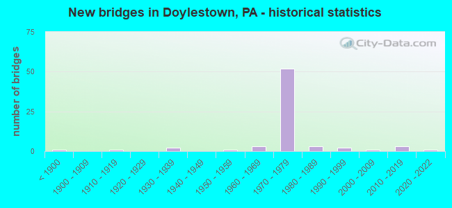
- New bridges - historical statistics
- 1Before 1900
- 11910-1919
- 21930-1939
- 11950-1959
- 31960-1969
- 521970-1979
- 31980-1989
- 21990-1999
- 12000-2009
- 32010-2019
- 12020-2022
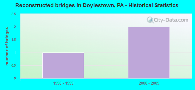
- Reconstructed bridges - Historical Statistics
- 11990-1999
- 22000-2009
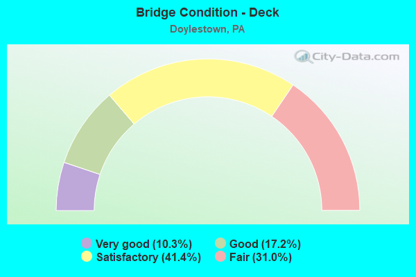
- Bridge Condition - Deck
- 10.3%Very good
- 17.2%Good
- 41.4%Satisfactory
- 31.0%Fair
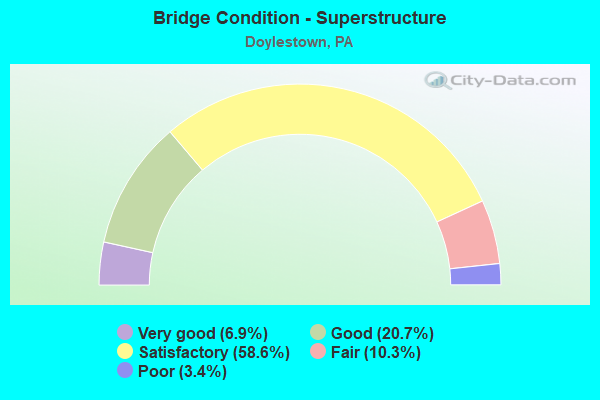
- Bridge Condition - Superstructure
- 6.9%Very good
- 20.7%Good
- 58.6%Satisfactory
- 10.3%Fair
- 3.4%Poor
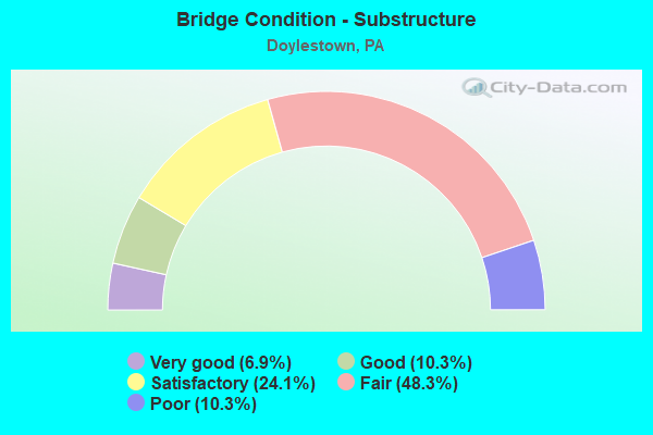
- Bridge Condition - Substructure
- 6.9%Very good
- 10.3%Good
- 24.1%Satisfactory
- 48.3%Fair
- 10.3%Poor
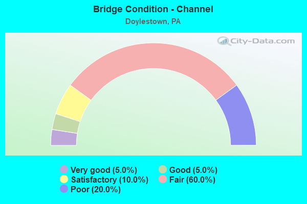
- Bridge Condition - Channel
- 5.0%Very good
- 5.0%Good
- 10.0%Satisfactory
- 60.0%Fair
- 20.0%Poor
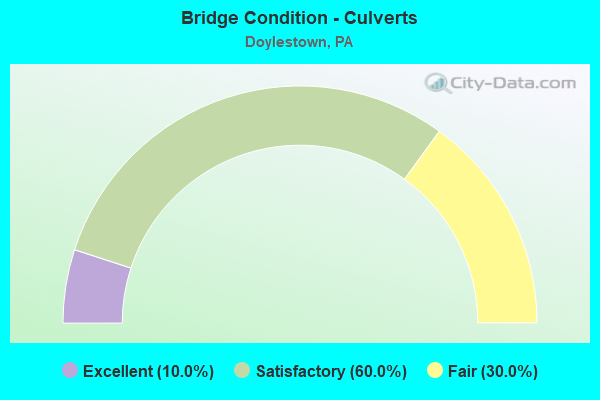
- Bridge Condition - Culverts
- 10.0%Excellent
- 60.0%Satisfactory
- 30.0%Fair
Find on map >> Show street view
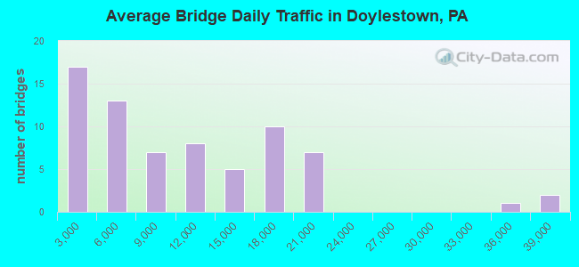
Structure Number: 692, Location: 1.2MI.N.EASTON RD. 28J01 (Lat: 40.297728, Lng: -75.145061), Route carried "under" structure: State highway , Year Built: 1973, Structure Length: 0. m, Average Daily Traffic: 5,244 (year 2022), Truck Traffic: 4%, Features Intersected: SEPTA, & LR 09041, Facility Carried by Structure: DOYLESTOWN BY-PASS
Minimum Vertical Clearance: 5.27m (17.29ft), Kilometerpoint: 6.970, Lanes on structure: 3, Lanes under structure: 2, Material/Design: Prestressed concrete, Design/Construction: Stringer/Multi-beam, Length of Maximum Span: 26.5m (86.9ft)
Find on map >> Show street view
Structure Number: 6921, Location: 611 BY-PASS 28K02 (Lat: 40.293456, Lng: -75.138081), Route carried "under" structure: State highway 611, Year Built: 1973, Structure Length: 0. m, Average Daily Traffic: 16,857 (year 2021), Truck Traffic: 4%, Features Intersected: LR 1068 (611 BY-PASS), Facility Carried by Structure: DOYLESTWN BYPAS NB
Minimum Vertical Clearance: 5.89m (19.32ft), Kilometerpoint: 9.720, Lanes on structure: 2, Lanes under structure: 3, Material/Design: Prestressed concrete, Design/Construction: Stringer/Multi-beam, Length of Maximum Span: 28.7m (94.2ft)
Find on map >> Show street view
Structure Number: 6921, Location: 611 BY-PASS 28K02 (Lat: 40.293456, Lng: -75.138081), Route carried "under" structure: State highway 611, Year Built: 1973, Structure Length: 0. m, Average Daily Traffic: 16,951 (year 2021), Truck Traffic: 4%, Features Intersected: LR 1068 (611 BY-PASS), Facility Carried by Structure: DOYLESTWN BYPAS NB
Minimum Vertical Clearance: 5.61m (18.41ft), Kilometerpoint: 9.682, Lanes on structure: 2, Lanes under structure: 3, Material/Design: Prestressed concrete, Design/Construction: Stringer/Multi-beam, Length of Maximum Span: 28.7m (94.2ft)
Find on map >> Show street view
Structure Number: 6922, Location: 611 BY-PASS 28K02 (Lat: 40.293689, Lng: -75.138125), Route carried "under" structure: State highway 611, Year Built: 1973, Structure Length: 0. m, Average Daily Traffic: 16,857 (year 2021), Truck Traffic: 4%, Features Intersected: 611 BY-PASS (LR1068), Facility Carried by Structure: DOYLESTWN BYPAS SB
Minimum Vertical Clearance: 4.85m (15.91ft), Kilometerpoint: 9.720, Lanes on structure: 1, Lanes under structure: 3, Material/Design: Prestressed concrete, Design/Construction: Stringer/Multi-beam, Length of Maximum Span: 28.7m (94.2ft)
Find on map >> Show street view
Structure Number: 6922, Location: 611 BY-PASS 28K02 (Lat: 40.293689, Lng: -75.138125), Route carried "under" structure: State highway 611, Year Built: 1973, Structure Length: 0. m, Average Daily Traffic: 16,951 (year 2021), Truck Traffic: 4%, Features Intersected: 611 BY-PASS (LR1068), Facility Carried by Structure: DOYLESTWN BYPAS SB
Minimum Vertical Clearance: 4.50m (14.76ft), Kilometerpoint: 9.682, Lanes on structure: 1, Lanes under structure: 3, Material/Design: Prestressed concrete, Design/Construction: Stringer/Multi-beam, Length of Maximum Span: 28.7m (94.2ft)
Find on map >> Show street view
Structure Number: 6926, Location: 1.2MI.EAST PA-611 23C13 (Lat: 40.301994, Lng: -75.118722), Route carried "under" structure: State highway , Year Built: 1973, Structure Length: 0. m, Average Daily Traffic: 5,036 (year 2022), Truck Traffic: 2%, Features Intersected: PEBBLE HILL ROAD, Facility Carried by Structure: DOYLESTWN BYPAS NB
Minimum Vertical Clearance: 5.00m (16.40ft), Kilometerpoint: 3.415, Lanes on structure: 2, Lanes under structure: 2, Material/Design: Prestressed concrete, Design/Construction: Stringer/Multi-beam, Length of Maximum Span: 26.5m (86.9ft)
Find on map >> Show street view
Structure Number: 6927, Location: 1.2MI.EAST PA-611 23C13 (Lat: 40.302117, Lng: -75.118925), Route carried "under" structure: State highway , Year Built: 1973, Structure Length: 0. m, Average Daily Traffic: 5,036 (year 2022), Truck Traffic: 2%, Features Intersected: PEBBLE HILL ROAD, Facility Carried by Structure: DOYLESTWN BYPAS SB
Minimum Vertical Clearance: 4.39m (14.40ft), Kilometerpoint: 3.415, Lanes on structure: 2, Lanes under structure: 2, Material/Design: Prestressed concrete, Design/Construction: Stringer/Multi-beam, Length of Maximum Span: 26.5m (86.9ft)
Find on map >> Show street view
Structure Number: 6928, Location: S.E.DOYLESTOWN 23D12 (Lat: 40.309950, Lng: -75.111217), Route carried "under" structure: Bypass US 202, Year Built: 1973, Structure Length: 0. m, Average Daily Traffic: 10,079 (year 2022), Truck Traffic: 10%, Features Intersected: DOYLESTOWN BYPASS(US202), Facility Carried by Structure: EAST ROAD (T350)
Minimum Vertical Clearance: 5.23m (17.16ft), Kilometerpoint: 11.206, Lanes on structure: 2, Lanes under structure: 2, Material/Design: Prestressed concrete, Design/Construction: Stringer/Multi-beam, Length of Maximum Span: 29.9m (98.1ft)
Find on map >> Show street view
Structure Number: 6928, Location: S.E.DOYLESTOWN 23D12 (Lat: 40.309950, Lng: -75.111217), Route carried "under" structure: Bypass US 202, Year Built: 1973, Structure Length: 0. m, Average Daily Traffic: 10,255 (year 2022), Truck Traffic: 9%, Features Intersected: DOYLESTOWN BYPASS(US202), Facility Carried by Structure: EAST ROAD (T350)
Minimum Vertical Clearance: 5.26m (17.26ft), Kilometerpoint: 11.219, Lanes on structure: 2, Lanes under structure: 2, Material/Design: Prestressed concrete, Design/Construction: Stringer/Multi-beam, Length of Maximum Span: 29.9m (98.1ft)
Find on map >> Show street view
Structure Number: 6983, Location: NORTH DOYLESTOWN 22K08 (Lat: 40.331508, Lng: -75.135106), Route carried "under" structure: State highway 611, Year Built: 1973, Structure Length: 0. m, Average Daily Traffic: 8,152 (year 2022), Truck Traffic: 13%, Features Intersected: DOYLESTOWN BYPASS, Facility Carried by Structure: SWAMP ROAD
Minimum Vertical Clearance: 4.62m (15.16ft), Kilometerpoint: 14.629, Lanes on structure: 5, Lanes under structure: 2, Material/Design: Prestressed concrete, Design/Construction: Stringer/Multi-beam, Length of Maximum Span: 24.1m (79.1ft)
Find on map >> Show street view
Structure Number: 6983, Location: NORTH DOYLESTOWN 22K08 (Lat: 40.331508, Lng: -75.135106), Route carried "under" structure: State highway 611, Year Built: 1973, Structure Length: 0. m, Average Daily Traffic: 8,381 (year 2022), Truck Traffic: 15%, Features Intersected: DOYLESTOWN BYPASS, Facility Carried by Structure: SWAMP ROAD
Minimum Vertical Clearance: 4.65m (15.26ft), Kilometerpoint: 14.623, Lanes on structure: 5, Lanes under structure: 2, Material/Design: Prestressed concrete, Design/Construction: Stringer/Multi-beam, Length of Maximum Span: 24.1m (79.1ft)
Find on map >> Show street view
Structure Number: 7065, Location: TURK RD;EASTON BYP.29B03 (Lat: 40.286697, Lng: -75.127028), Route carried "under" structure: City street 7205, Year Built: 1973, Structure Length: 0. m, Average Daily Traffic: 350 (year 1980), Truck Traffic: 3%, Features Intersected: TURK ROAD (TWP-389), Facility Carried by Structure: DOYLESTOWN BY-PASS
Minimum Vertical Clearance: 4.63m (15.19ft), Kilometerpoint: 0.000, Lanes on structure: 4, Lanes under structure: 2, Material/Design: Prestressed concrete, Design/Construction: Stringer/Multi-beam, Length of Maximum Span: 17.7m (58.1ft)
Find on map >> Show street view
Structure Number: 7066, Location: SOUTH DOYLESTOWN 29A02 (Lat: 40.290972, Lng: -75.133194), Route carried "under" structure: Bypass State highway 611, Year Built: 1973, Structure Length: 0. m, Average Daily Traffic: 16,987 (year 2022), Truck Traffic: 12%, Features Intersected: DOYLESTOWN BYPASS, Facility Carried by Structure: NEW BRITAIN ROAD
Minimum Vertical Clearance: 4.54m (14.90ft), Kilometerpoint: 9.225, Lanes on structure: 2, Lanes under structure: 2, Material/Design: Steel, Design/Construction: Stringer/Multi-beam, Length of Maximum Span: 32.9m (107.9ft)
Find on map >> Show street view
Structure Number: 7066, Location: SOUTH DOYLESTOWN 29A02 (Lat: 40.290972, Lng: -75.133194), Route carried "under" structure: Bypass State highway 611, Year Built: 1973, Structure Length: 0. m, Average Daily Traffic: 18,004 (year 2022), Truck Traffic: 10%, Features Intersected: DOYLESTOWN BYPASS, Facility Carried by Structure: NEW BRITAIN ROAD
Minimum Vertical Clearance: 4.45m (14.60ft), Kilometerpoint: 9.191, Lanes on structure: 2, Lanes under structure: 3, Material/Design: Steel, Design/Construction: Stringer/Multi-beam, Length of Maximum Span: 32.9m (107.9ft)
Find on map >> Show street view
Structure Number: 7068, Location: N.END DOYLESTOWN 22J10 (Lat: 40.321269, Lng: -75.142542), Route carried "under" structure: Bypass State highway 611, Year Built: 1973, Structure Length: 0. m, Average Daily Traffic: 13,689 (year 2020), Truck Traffic: 9%, Features Intersected: DOYLESTOWN BYPASS, Facility Carried by Structure: BROAD STREET(T350)
Minimum Vertical Clearance: 4.57m (14.99ft), Kilometerpoint: 13.317, Lanes on structure: 2, Lanes under structure: 2, Material/Design: Prestressed concrete, Design/Construction: Stringer/Multi-beam, Length of Maximum Span: 24.7m (81.0ft)
Find on map >> Show street view
Structure Number: 7068, Location: N.END DOYLESTOWN 22J10 (Lat: 40.321269, Lng: -75.142542), Route carried "under" structure: Bypass State highway 611, Year Built: 1973, Structure Length: 0. m, Average Daily Traffic: 13,652 (year 2020), Truck Traffic: 8%, Features Intersected: DOYLESTOWN BYPASS, Facility Carried by Structure: BROAD STREET(T350)
Minimum Vertical Clearance: 4.42m (14.50ft), Kilometerpoint: 13.316, Lanes on structure: 2, Lanes under structure: 2, Material/Design: Prestressed concrete, Design/Construction: Stringer/Multi-beam, Length of Maximum Span: 24.7m (81.0ft)
Find on map >> Show street view
Structure Number: 707, Location: .4MI.S.LR 156 23A07 (Lat: 40.337878, Lng: -75.134036), Route carried "under" structure: State highway , Year Built: 1973, Structure Length: 0. m, Average Daily Traffic: 750 (year 1980), Truck Traffic: 7%, Features Intersected: SAW MILL ROAD(T401), Facility Carried by Structure: DOYLESTWN BYPAS NB
Minimum Vertical Clearance: 4.72m (15.49ft), Kilometerpoint: 0.000, Lanes on structure: 2, Lanes under structure: 2, Material/Design: Prestressed concrete, Design/Construction: Stringer/Multi-beam, Length of Maximum Span: 26.2m (86.0ft)
Find on map >> Show street view
Structure Number: 7071, Location: .4MI.SOUTH LR156 23A07 (Lat: 40.337658, Lng: -75.134281), Route carried "under" structure: State highway , Year Built: 1973, Structure Length: 0. m, Average Daily Traffic: 750 (year 1980), Truck Traffic: 7%, Features Intersected: SAW MILL ROAD(T401), Facility Carried by Structure: DOYLESTWN BYPAS SB
Minimum Vertical Clearance: 4.88m (16.01ft), Kilometerpoint: 0.000, Lanes on structure: 2, Lanes under structure: 2, Material/Design: Prestressed concrete, Design/Construction: Stringer/Multi-beam, Length of Maximum Span: 23.5m (77.1ft)
Find on map >> Show street view
Structure Number: 7072, Location: DOYLESTOWN 23A06 (Lat: 40.343333, Lng: -75.133333), Route carried "under" structure: State highway , Year Built: 1973, Structure Length: 0. m, Average Daily Traffic: 7,188 (year 2021), Truck Traffic: 6%, Features Intersected: EASTON ROAD, Facility Carried by Structure: DOYLESTWN BYPAS NB
Minimum Vertical Clearance: 4.37m (14.34ft), Kilometerpoint: 6.202, Lanes on structure: 2, Lanes under structure: 3, Material/Design: Prestressed concrete, Design/Construction: Stringer/Multi-beam, Length of Maximum Span: 30.2m (99.1ft)
Find on map >> Show street view
Structure Number: 7093, Location: US 611 BYPASS 29B03 (Lat: 40.287306, Lng: -75.127167), Route carried "under" structure: City street , Year Built: 1973, Structure Length: 0. m, Average Daily Traffic: 350 (year 1980), Truck Traffic: 1%, Features Intersected: TURK ROAD(T389), Facility Carried by Structure: EASTON ROAD
Minimum Vertical Clearance: 6.58m (21.59ft), Kilometerpoint: 0.000, Lanes on structure: 1, Lanes under structure: 2, Material/Design: Prestressed concrete, Design/Construction: Stringer/Multi-beam, Length of Maximum Span: 20.1m (65.9ft)
Find on map >> Show street view
Structure Number: 7094, Location: US 611 BYPASS 29A03 (Lat: 40.289308, Lng: -75.129744), Route carried "under" structure: State highway 611, Year Built: 1973, Structure Length: 0. m, Average Daily Traffic: 16,987 (year 2022), Truck Traffic: 12%, Features Intersected: 611 BY-PASS, Facility Carried by Structure: EASTON ROAD
Minimum Vertical Clearance: 4.54m (14.90ft), Kilometerpoint: 8.541, Lanes on structure: 1, Lanes under structure: 2, Material/Design: Prestressed concrete, Design/Construction: Stringer/Multi-beam, Length of Maximum Span: 27.7m (90.9ft)
Find on map >> Show street view
Structure Number: 7094, Location: US 611 BYPASS 29A03 (Lat: 40.289308, Lng: -75.129744), Route carried "under" structure: State highway 611, Year Built: 1973, Structure Length: 0. m, Average Daily Traffic: 18,004 (year 2022), Truck Traffic: 10%, Features Intersected: 611 BY-PASS, Facility Carried by Structure: EASTON ROAD
Minimum Vertical Clearance: 4.72m (15.49ft), Kilometerpoint: 8.507, Lanes on structure: 1, Lanes under structure: 2, Material/Design: Prestressed concrete, Design/Construction: Stringer/Multi-beam, Length of Maximum Span: 27.7m (90.9ft)
Find on map >> Show street view
Structure Number: 7095, Location: SOUTH DOYLESTOWN 29B01 (Lat: 40.298806, Lng: -75.127933), Route carried "under" structure: Bypass US 202, Year Built: 1973, Structure Length: 0. m, Average Daily Traffic: 10,255 (year 2022), Truck Traffic: 9%, Features Intersected: US 202 BY-PASS, Facility Carried by Structure: SOUTH MAIN STREET
Minimum Vertical Clearance: 5.56m (18.24ft), Kilometerpoint: 8.721, Lanes on structure: 2, Lanes under structure: 2, Material/Design: Prestressed concrete, Design/Construction: Stringer/Multi-beam, Length of Maximum Span: 24.4m (80.1ft)
Find on map >> Show street view
Structure Number: 7095, Location: SOUTH DOYLESTOWN 29B01 (Lat: 40.298806, Lng: -75.127933), Route carried "under" structure: Bypass US 202, Year Built: 1973, Structure Length: 0. m, Average Daily Traffic: 5,339 (year 2020), Truck Traffic: 10%, Features Intersected: US 202 BY-PASS, Facility Carried by Structure: SOUTH MAIN STREET
Minimum Vertical Clearance: 4.70m (15.42ft), Kilometerpoint: 8.721, Lanes on structure: 2, Lanes under structure: 2, Material/Design: Prestressed concrete, Design/Construction: Stringer/Multi-beam, Length of Maximum Span: 24.4m (80.1ft)
Find on map >> Show street view
Structure Number: 7116, Location: DANBORO 22K05 (Lat: 40.350986, Lng: -75.136847), Route carried "under" structure: State highway 611, Year Built: 1973, Structure Length: 0. m, Average Daily Traffic: 15,977 (year 2020), Truck Traffic: 5%, Features Intersected: EASTON ROAD, Facility Carried by Structure: FERRY ROAD
Minimum Vertical Clearance: 4.52m (14.83ft), Kilometerpoint: 16.953, Lanes on structure: 2, Lanes under structure: 4, Material/Design: Prestressed concrete, Design/Construction: Stringer/Multi-beam, Length of Maximum Span: 30.2m (99.1ft)
Find on map >> Show street view
Structure Number: 7371, Location: WEST DOYLESTOWN 22J11 (Lat: 40.314331, Lng: -75.147236), Route carried "under" structure: Bypass State highway 611, Year Built: 1973, Structure Length: 0. m, Average Daily Traffic: 13,689 (year 2020), Truck Traffic: 9%, Features Intersected: PA 611 BY-PASS(LR1068), Facility Carried by Structure: LIMEKILN ROAD
Minimum Vertical Clearance: 4.51m (14.80ft), Kilometerpoint: 12.450, Lanes on structure: 2, Lanes under structure: 2, Material/Design: Prestressed concrete, Design/Construction: Stringer/Multi-beam, Length of Maximum Span: 24.1m (79.1ft)
Find on map >> Show street view
Structure Number: 7371, Location: WEST DOYLESTOWN 22J11 (Lat: 40.314331, Lng: -75.147236), Route carried "under" structure: Bypass State highway 611, Year Built: 1973, Structure Length: 0. m, Average Daily Traffic: 13,652 (year 2020), Truck Traffic: 8%, Features Intersected: PA 611 BY-PASS(LR1068), Facility Carried by Structure: LIMEKILN ROAD
Minimum Vertical Clearance: 4.72m (15.49ft), Kilometerpoint: 12.447, Lanes on structure: 2, Lanes under structure: 2, Material/Design: Prestressed concrete, Design/Construction: Stringer/Multi-beam, Length of Maximum Span: 24.1m (79.1ft)
Find on map >> Show street view
Structure Number: 7374, Location: NORTH DOYLESTOWN 22K09 (Lat: 40.326992, Lng: -75.138717), Route carried "under" structure: Bypass State highway 611, Year Built: 1973, Structure Length: 0. m, Average Daily Traffic: 18,600 (year 2022), Truck Traffic: 11%, Features Intersected: TR 611 BY-PASS, Facility Carried by Structure: OLD DUBLIN PIKE
Minimum Vertical Clearance: 4.98m (16.34ft), Kilometerpoint: 14.032, Lanes on structure: 2, Lanes under structure: 2, Material/Design: Prestressed concrete, Design/Construction: Stringer/Multi-beam, Length of Maximum Span: 23.8m (78.1ft)
Find on map >> Show street view
Structure Number: 7374, Location: NORTH DOYLESTOWN 22K09 (Lat: 40.326992, Lng: -75.138717), Route carried "under" structure: Bypass State highway 611, Year Built: 1973, Structure Length: 0. m, Average Daily Traffic: 18,158 (year 2022), Truck Traffic: 12%, Features Intersected: TR 611 BY-PASS, Facility Carried by Structure: OLD DUBLIN PIKE
Minimum Vertical Clearance: 4.65m (15.26ft), Kilometerpoint: 14.025, Lanes on structure: 2, Lanes under structure: 2, Material/Design: Prestressed concrete, Design/Construction: Stringer/Multi-beam, Length of Maximum Span: 23.8m (78.1ft)
Find on map >> Show street view
Structure Number: 46945, Location: .25 MI. S. PA 611 3034H04 (Lat: 40.291611, Lng: -75.141689), Route carried "under" structure: City street , Year Built: 2012, Structure Length: 0. m, Average Daily Traffic: 1,500 (year 2012), Features Intersected: NEW BRITAIN ROAD, Facility Carried by Structure: US 202 PARKWAY
Minimum Vertical Clearance: 4.44m (14.57ft), Kilometerpoint: 0.000, Lanes on structure: 3, Lanes under structure: 2, Material/Design: Prestressed concrete, Design/Construction: Box Beam or Girders - Single/Spread, Length of Maximum Span: 19.5m (64.0ft)