Bridge Statistics for Duncannon, Pennsylvania (PA)
Condition, Traffic, Stress, Structural Evaluation, Project Costs
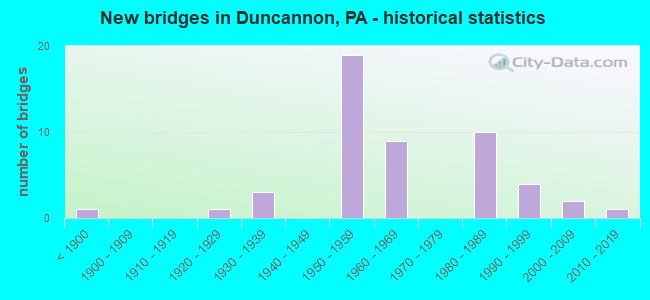
- New bridges - historical statistics
- 1Before 1900
- 11920-1929
- 31930-1939
- 191950-1959
- 91960-1969
- 101980-1989
- 41990-1999
- 22000-2009
- 12010-2019
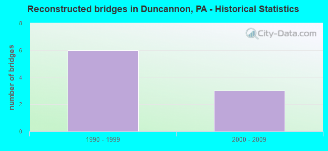
- Reconstructed bridges - Historical Statistics
- 61990-1999
- 32000-2009
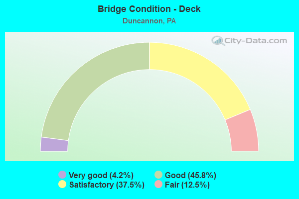
- Bridge Condition - Deck
- 4.2%Very good
- 45.8%Good
- 37.5%Satisfactory
- 12.5%Fair
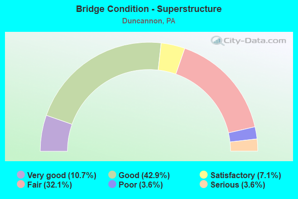
- Bridge Condition - Superstructure
- 10.7%Very good
- 42.9%Good
- 7.1%Satisfactory
- 32.1%Fair
- 3.6%Poor
- 3.6%Serious
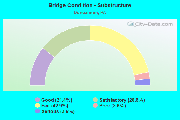
- Bridge Condition - Substructure
- 21.4%Good
- 28.6%Satisfactory
- 42.9%Fair
- 3.6%Poor
- 3.6%Serious
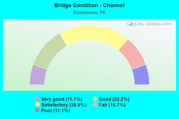
- Bridge Condition - Channel
- 11.1%Very good
- 22.2%Good
- 38.9%Satisfactory
- 16.7%Fair
- 11.1%Poor
Find on map >> Show street view
Structure Number: 14142, Location: NEAR AMITY HALL (Lat: 40.418889, Lng: -77.016806), Route carried "on" structure: US 11, Year Built: 1959, Year Reconstructed: 2007, Status: Open, Structure Length: 39.75m (130.41ft), Average Daily Traffic: 7,326 (year 2021), Truck Traffic: 9%, Average Future Daily Traffic: 8,987 (year 2032), Design Load: HS 25 or greater, Features Intersected: Juniata River;Norfolk So
Minimum Vertical Clearance: 30+ m (98+ ft), Kilometerpoint: 0.000, Lanes on structure: 4, Base Highway Network: Yes, Owner: State Highway Agency, Approaching Roadway Width: 21.6m (70.9ft), Material/Design: Steel continuous, Design/Construction: Girder and Floorbeam System, Number Of Spans In Main Unit: 12, Length of Maximum Span: 35.1m (115.2ft), Curb or Sidewalk Widths: Left: 0.2m (0.7ft), Right: 0.2m (0.7ft), Curb-To-Curb Width: 17.7m (58.1ft), Out-to-Out Width: 19.7m (64.6ft)
Condition: Deck: Fair, Superstructure: Good, Substructure: Satisfactory, Channel: Fair, Operating Rating: 63.5 metric tons, Method Used To Determine Operating Rating: Load Factor (LF), Inventory Rating: 38.1 metric tons, Method Used To Determine Inventory Rating: Load Factor (LF), Structural Evaluation: Equal to present minimum criteria, Deck Geometry: Somewhat better than minimum adequacy, Underclear: High priority of corrective action, Waterway Adequacy: Superior to present desirable criteria, Approach Roadway Alignment: Equal to present desirable criteria, Length Of Structure Improvement: 41.30m (135.50ft), Designated Inspection Frequency: Every 24 months, Critical Feature Inspection Frequency: Every 24 months, Underwater Inspection Frequency: Every 60 months, Inspection Date: March 2021, Critical Feature Inspection Date: March 2021, Underwater Inspection Date: September 2020, Bridge Improvement Cost: $863,000, Roadway Improvement Cost: $2,543,000, Total Project Cost: $11,654,000, Deck Structure Type: Concrete Cast-file-Place, Wearing Surface/Protective System: Wearing Surface: Latex Concrete
Find on map >> Show street view
Structure Number: 14144, Location: CLARKS FERRY (Lat: 40.400425, Lng: -77.009611), Route carried "on" structure: US 22, Year Built: 1986, Status: Open, Structure Length: 33.80m (110.89ft), Average Daily Traffic: 21,289 (year 2022), Truck Traffic: 12%, Average Future Daily Traffic: 27,632 (year 2032), Design Load: HS 25 or greater, Features Intersected: SUSQUEHANNA RIVER
Minimum Vertical Clearance: 30+ m (98+ ft), Kilometerpoint: 2.681, Lanes on structure: 2, Base Highway Network: Yes, Owner: State Highway Agency, Approaching Roadway Width: 11.6m (38.1ft), Skew: 10 degrees, Material/Design: Prestressed concrete, Design/Construction: Stringer/Multi-beam, Number Of Spans In Main Unit: 8, Length of Maximum Span: 42.4m (139.1ft), Curb or Sidewalk Widths: Left: 0.2m (0.7ft), Right: 1.2m (3.9ft), Curb-To-Curb Width: 11.5m (37.7ft), Out-to-Out Width: 14.2m (46.6ft)
Condition: Deck: Good, Superstructure: Good, Substructure: Fair, Channel: Satisfactory, Inventory Rating: 40.8 metric tons, Method Used To Determine Inventory Rating: Load Factor (LF), Structural Evaluation: Somewhat better than minimum adequacy, Deck Geometry: Equal to present minimum criteria, Waterway Adequacy: Superior to present desirable criteria, Approach Roadway Alignment: Equal to present desirable criteria, Length Of Structure Improvement: 34.30m (112.53ft), Designated Inspection Frequency: Every 24 months, Underwater Inspection Frequency: Every 60 months, Inspection Date: October 2020, Underwater Inspection Date: September 2020, Deck Structure Type: Concrete Cast-file-Place, Wearing Surface/Protective System: Wearing Surface: Monolithic Concrete, Deck Protection: Epoxy Coated Reinforcing
Find on map >> Show street view
Structure Number: 14146, Location: CLARKS FERRY (Lat: 40.395647, Lng: -77.009428), Route carried "on" structure: US 22, Year Built: 1986, Status: Open, Structure Length: 41.12m (134.91ft), Average Daily Traffic: 21,289 (year 2022), Truck Traffic: 12%, Average Future Daily Traffic: 27,632 (year 2032), Design Load: HS 25 or greater, Features Intersected: SUSQ R; SR 0147 SB, RP
Minimum Vertical Clearance: 30+ m (98+ ft), Kilometerpoint: 2.681, Lanes on structure: 2, Lanes under structure: 2, Base Highway Network: Yes, Owner: State Highway Agency, Approaching Roadway Width: 11.6m (38.1ft), Skew: 10 degrees, Material/Design: Steel continuous, Design/Construction: Stringer/Multi-beam, Number Of Spans In Main Unit: 9, Length of Maximum Span: 49.7m (163.1ft), Curb or Sidewalk Widths: Left: 0.2m (0.7ft), Right: 1.2m (3.9ft), Curb-To-Curb Width: 11.5m (37.7ft), Out-to-Out Width: 12.6m (41.3ft)
Condition: Deck: Satisfactory, Superstructure: Good, Substructure: Satisfactory, Channel: Satisfactory, Operating Rating: 57.2 metric tons, Method Used To Determine Operating Rating: Load Factor (LF), Inventory Rating: 34.5 metric tons, Method Used To Determine Inventory Rating: Load Factor (LF), Structural Evaluation: Equal to present minimum criteria, Deck Geometry: Equal to present minimum criteria, Underclear: High priority of corrective action, Waterway Adequacy: Superior to present desirable criteria, Approach Roadway Alignment: Better than present minimum criteria, Length Of Structure Improvement: 41.60m (136.48ft), Designated Inspection Frequency: Every 24 months, Underwater Inspection Frequency: Every 60 months, Inspection Date: October 2020, Underwater Inspection Date: September 2020, Deck Structure Type: Concrete Cast-file-Place, Wearing Surface/Protective System: Wearing Surface: Monolithic Concrete, Deck Protection: Epoxy Coated Reinforcing
Find on map >> Show street view
Structure Number: 14291, Location: QUARTER MI S OF INGLENOOK (Lat: 40.409803, Lng: -76.984131), Route carried "on" structure: State highway 147, Year Built: 1860, Status: Open, Structure Length: 2.44m (8.01ft), Average Daily Traffic: 6,521 (year 2022), Truck Traffic: 9%, Average Future Daily Traffic: 8,276 (year 2032), Features Intersected: POWELLS CREEK
Minimum Vertical Clearance: 30+ m (98+ ft), Kilometerpoint: 2.472, Lanes on structure: 2, Base Highway Network: Yes, Owner: State Highway Agency, Approaching Roadway Width: 8.5m (27.9ft), Material/Design: Masonry, Design/Construction: Arch - Deck, Number Of Spans In Main Unit: 3, Length of Maximum Span: 7.3m (24.0ft), Curb or Sidewalk Widths: Left: 0.9m (3.0ft), Right: 0.9m (3.0ft), Curb-To-Curb Width: 17.9m (58.7ft), Out-to-Out Width: 19.8m (65.0ft)
Condition: Superstructure: Serious, Substructure: Poor, Channel: Satisfactory, Operating Rating: 49.0 metric tons, Method Used To Determine Operating Rating: Field evaluation and documented engineering judgment, Inventory Rating: 32.7 metric tons, Method Used To Determine Inventory Rating: Field evaluation and documented engineering judgment, Structural Evaluation: High priority of corrective action, Deck Geometry: Superior to present desirable criteria, Waterway Adequacy: Better than present minimum criteria, Approach Roadway Alignment: Equal to present desirable criteria, Length Of Structure Improvement: 3.20m (10.50ft), Designated Inspection Frequency: Every 24 months, Other Special Inspection Frequency: Every 12 months, Inspection Date: April 2020, Other Special Inspection Date: April 2021, Bridge Improvement Cost: $15,000, Roadway Improvement Cost: $43,000, Total Project Cost: $199,000
Find on map >> Show street view
Structure Number: 14293, Location: OVER R.R. @ INGLENOOK (Lat: 40.413086, Lng: -76.981403), Route carried "on" structure: State highway 147, Year Built: 1984, Status: Open, Structure Length: 6.40m (21.00ft), Average Daily Traffic: 6,521 (year 2022), Truck Traffic: 9%, Average Future Daily Traffic: 8,276 (year 2032), Design Load: HS 25 or greater, Features Intersected: Norfolk Southern RR
Minimum Vertical Clearance: 30+ m (98+ ft), Kilometerpoint: 2.472, Lanes on structure: 2, Base Highway Network: Yes, Owner: State Highway Agency, Approaching Roadway Width: 11.6m (38.1ft), Material/Design: Steel continuous, Design/Construction: Stringer/Multi-beam, Number Of Spans In Main Unit: 2, Length of Maximum Span: 31.4m (103.0ft), Curb or Sidewalk Widths: Left: 0.2m (0.7ft), Right: 0.2m (0.7ft), Curb-To-Curb Width: 12.2m (40.0ft), Out-to-Out Width: 13.3m (43.6ft)
Condition: Deck: Good, Superstructure: Good, Substructure: Fair, Operating Rating: 78.0 metric tons, Method Used To Determine Operating Rating: Load Factor (LF), Inventory Rating: 47.2 metric tons, Method Used To Determine Inventory Rating: Load Factor (LF), Structural Evaluation: Somewhat better than minimum adequacy, Deck Geometry: Somewhat better than minimum adequacy, Underclear: High priority of corrective action, Approach Roadway Alignment: Somewhat better than minimum adequacy, Length Of Structure Improvement: 7.40m (24.28ft), Designated Inspection Frequency: Every 24 months, Critical Feature Inspection Frequency: Every 24 months, Inspection Date: September 2020, Critical Feature Inspection Date: September 2020, Deck Structure Type: Concrete Cast-file-Place, Wearing Surface/Protective System: Wearing Surface: Monolithic Concrete, Deck Protection: Epoxy Coated Reinforcing
Find on map >> Show street view
Structure Number: 14418, Location: N. DUNCANNON (Lat: 40.402661, Lng: -77.013253), Route carried "on" structure: State highway 849, Year Built: 1922, Status: Open, Structure Length: 19.81m (64.99ft), Average Daily Traffic: 4,047 (year 2020), Truck Traffic: 6%, Average Future Daily Traffic: 6,880 (year 2036), Features Intersected: Juniata River
Minimum Vertical Clearance: 30+ m (98+ ft), Kilometerpoint: 0.000, Lanes on structure: 2, Owner: State Highway Agency, Approaching Roadway Width: 8.2m (26.9ft), Material/Design: Concrete, Design/Construction: Arch - Deck, Number Of Spans In Main Unit: 5, Length of Maximum Span: 39.6m (129.9ft), Curb or Sidewalk Widths: Left: 1.7m (5.6ft), Right: 0.2m (0.7ft), Curb-To-Curb Width: 6.1m (20.0ft), Out-to-Out Width: 8.8m (28.9ft)
Condition: Superstructure: Fair, Substructure: Fair, Channel: Poor, Operating Rating: 49.0 metric tons, Method Used To Determine Operating Rating: Field evaluation and documented engineering judgment, Inventory Rating: 32.7 metric tons, Method Used To Determine Inventory Rating: Field evaluation and documented engineering judgment, Structural Evaluation: Somewhat better than minimum adequacy, Deck Geometry: High priority of replacement, Waterway Adequacy: Equal to present desirable criteria, Approach Roadway Alignment: Equal to present desirable criteria, Length Of Structure Improvement: 20.50m (67.26ft), Designated Inspection Frequency: Every 24 months, Underwater Inspection Frequency: Every 24 months, Inspection Date: October 2020, Underwater Inspection Date: September 2020, Bridge Improvement Cost: $209,000, Roadway Improvement Cost: $615,000, Total Project Cost: $2,819,000
Find on map >> Show street view
Structure Number: 14768, Location: CLARKS FERRY (Lat: 40.397406, Lng: -77.008614), Route carried "on" structure: Ramp State highway , Year Built: 1986, Status: Open, Structure Length: 23.74m (77.89ft), Average Daily Traffic: 1,175 (year 2022), Truck Traffic: 7%, Average Future Daily Traffic: 1,387 (year 2032), Design Load: HS 25 or greater, Features Intersected: SUSQUEHANNA RIVER, Facility Carried by Structure: SR 8004, RAMP-B,EB
Minimum Vertical Clearance: 4.77m (15.65ft), Kilometerpoint: 0.000, Lanes on structure: 1, Owner: State Highway Agency, Approaching Roadway Width: 12.2m (40.0ft), Skew: 9 degrees, Material/Design: Steel continuous, Design/Construction: Stringer/Multi-beam, Number Of Spans In Main Unit: 6, Length of Maximum Span: 47.9m (157.2ft), Curb or Sidewalk Widths: Left: 0.2m (0.7ft), Right: 1.2m (3.9ft), Curb-To-Curb Width: 6.4m (21.0ft), Out-to-Out Width: 9.3m (30.5ft)
Condition: Deck: Satisfactory, Superstructure: Satisfactory, Substructure: Fair, Channel: Satisfactory, Operating Rating: 66.2 metric tons, Method Used To Determine Operating Rating: Load Factor (LF), Inventory Rating: 39.9 metric tons, Method Used To Determine Inventory Rating: Load Factor (LF), Structural Evaluation: Somewhat better than minimum adequacy, Deck Geometry: Somewhat better than minimum adequacy, Waterway Adequacy: Superior to present desirable criteria, Approach Roadway Alignment: Equal to present desirable criteria, Length Of Structure Improvement: 24.20m (79.40ft), Designated Inspection Frequency: Every 24 months, Critical Feature Inspection Frequency: Every 24 months, Underwater Inspection Frequency: Every 60 months, Inspection Date: October 2020, Critical Feature Inspection Date: October 2020, Underwater Inspection Date: September 2020, Deck Structure Type: Concrete Cast-file-Place, Wearing Surface/Protective System: Wearing Surface: Monolithic Concrete, Deck Protection: Epoxy Coated Reinforcing
Find on map >> Show street view
Structure Number: 14769, Location: RAMP A; CLARKS FERRY BR. (Lat: 40.397775, Lng: -77.007925), Route carried "on" structure: Ramp State highway , Year Built: 1986, Status: Open, Structure Length: 16.89m (55.41ft), Average Daily Traffic: 1,154 (year 2022), Truck Traffic: 7%, Average Future Daily Traffic: 1,365 (year 2032), Design Load: HS 25 or greater, Features Intersected: SUSQUEHANNA RIVER, Facility Carried by Structure: WB RP A;SR 8004
Minimum Vertical Clearance: 30+ m (98+ ft), Kilometerpoint: 0.000, Lanes on structure: 1, Owner: State Highway Agency, Approaching Roadway Width: 12.2m (40.0ft), Material/Design: Steel continuous, Design/Construction: Stringer/Multi-beam, Number Of Spans In Main Unit: 4, Length of Maximum Span: 43.0m (141.1ft), Curb or Sidewalk Widths: Left: 0.2m (0.7ft), Right: 0.2m (0.7ft), Curb-To-Curb Width: 6.4m (21.0ft), Out-to-Out Width: 7.8m (25.6ft)
Condition: Deck: Good, Superstructure: Good, Substructure: Satisfactory, Channel: Satisfactory, Operating Rating: 78.9 metric tons, Method Used To Determine Operating Rating: Load Factor (LF), Inventory Rating: 47.2 metric tons, Method Used To Determine Inventory Rating: Load Factor (LF), Structural Evaluation: Equal to present minimum criteria, Deck Geometry: Somewhat better than minimum adequacy, Waterway Adequacy: Superior to present desirable criteria, Approach Roadway Alignment: Meets minimum limits, Length Of Structure Improvement: 17.60m (57.74ft), Designated Inspection Frequency: Every 24 months, Critical Feature Inspection Frequency: Every 24 months, Underwater Inspection Frequency: Every 60 months, Inspection Date: October 2020, Critical Feature Inspection Date: October 2020, Underwater Inspection Date: September 2020, Deck Structure Type: Concrete Cast-file-Place, Wearing Surface/Protective System: Wearing Surface: Monolithic Concrete, Deck Protection: Epoxy Coated Reinforcing
Find on map >> Show street view
Structure Number: 14782, Location: 2 MILES N.OF CLARKS FERRY (Lat: 40.428333, Lng: -77.016667), Route carried "on" structure: Ramp State highway , Year Built: 1959, Status: Open, Structure Length: 2.71m (8.89ft), Average Daily Traffic: 150 (year 2015), Truck Traffic: 7%, Average Future Daily Traffic: 251 (year 2032), Design Load: HS 20, Features Intersected: US11&15, Facility Carried by Structure: SR 8037 NB
Minimum Vertical Clearance: 30+ m (98+ ft), Kilometerpoint: 0.000, Lanes on structure: 1, Lanes under structure: 8, Owner: State Highway Agency, Approaching Roadway Width: 8.5m (27.9ft), Skew: 3 degrees, Material/Design: Prestressed concrete, Design/Construction: Box Beam or Girders - Multiple, Number Of Spans In Main Unit: 1, Length of Maximum Span: 26.2m (86.0ft), Curb or Sidewalk Widths: Left: 0.2m (0.7ft), Right: 0.2m (0.7ft), Curb-To-Curb Width: 8.5m (27.9ft), Out-to-Out Width: 9.6m (31.5ft)
Condition: Deck: Satisfactory, Superstructure: Fair, Substructure: Fair, Operating Rating: 89.8 metric tons, Method Used To Determine Operating Rating: Load Factor (LF), Inventory Rating: 41.7 metric tons, Method Used To Determine Inventory Rating: Load Factor (LF), Structural Evaluation: Somewhat better than minimum adequacy, Deck Geometry: Superior to present desirable criteria, Underclear: Equal to present minimum criteria, Approach Roadway Alignment: Equal to present desirable criteria, Length Of Structure Improvement: 3.60m (11.81ft), Designated Inspection Frequency: Every 24 months, Inspection Date: September 2020, Bridge Improvement Cost: $8,000, Roadway Improvement Cost: $24,000, Total Project Cost: $109,000, Deck Structure Type: Concrete Cast-file-Place, Wearing Surface/Protective System: Wearing Surface: Latex Concrete
Find on map >> Show street view
Structure Number: 29429, Location: NEAR DUNCANNON BORO (Lat: 40.383306, Lng: -77.028992), Route carried "on" structure: US 11, Year Built: 1959, Year Reconstructed: 1995, Status: Open, Structure Length: 13.44m (44.09ft), Average Daily Traffic: 8,682 (year 2020), Truck Traffic: 9%, Average Future Daily Traffic: 14,694 (year 2032), Design Load: HS 25 or greater, Features Intersected: SHERMANS CREEK; T-309
Minimum Vertical Clearance: 30+ m (98+ ft), Kilometerpoint: 13.570, Lanes on structure: 4, Lanes under structure: 2, Base Highway Network: Yes, Owner: State Highway Agency, Approaching Roadway Width: 20.7m (67.9ft), Skew: 31 degrees, Material/Design: Prestressed concrete, Design/Construction: Box Beam or Girders - Multiple, Number Of Spans In Main Unit: 5, Length of Maximum Span: 29.9m (98.1ft), Curb or Sidewalk Widths: Left: 0.2m (0.7ft), Right: 0.2m (0.7ft), Curb-To-Curb Width: 18.0m (59.1ft), Out-to-Out Width: 20.0m (65.6ft)
Condition: Deck: Fair, Superstructure: Fair, Substructure: Fair, Channel: Satisfactory, Inventory Rating: 29.0 metric tons, Method Used To Determine Inventory Rating: Load Factor (LF), Structural Evaluation: Somewhat better than minimum adequacy, Deck Geometry: Somewhat better than minimum adequacy, Underclear: High priority of corrective action, Waterway Adequacy: Superior to present desirable criteria, Approach Roadway Alignment: Equal to present desirable criteria, Length Of Structure Improvement: 14.40m (47.24ft), Designated Inspection Frequency: Every 24 months, Underwater Inspection Frequency: Every 60 months, Inspection Date: May 2021, Underwater Inspection Date: August 2020, Deck Structure Type: Concrete Cast-file-Place, Wearing Surface/Protective System: Wearing Surface: Monolithic Concrete, Deck Protection: Epoxy Coated Reinforcing
Find on map >> Show street view
Structure Number: 29431, Location: NEAR DUNCANNON BORO (Lat: 40.387344, Lng: -77.031225), Route carried "on" structure: US 11, Year Built: 1959, Year Reconstructed: 1995, Status: Open, Structure Length: 1.68m (5.51ft), Average Daily Traffic: 7,797 (year 2021), Truck Traffic: 9%, Average Future Daily Traffic: 8,862 (year 2032), Design Load: HS 20, Features Intersected: FISHER STREET (RAMP)
Minimum Vertical Clearance: 0.00m, Kilometerpoint: 13.570, Lanes on structure: 2, Lanes under structure: 1, Base Highway Network: Yes, Owner: State Highway Agency, Approaching Roadway Width: 20.4m (66.9ft), Skew: 34 degrees, Material/Design: Prestressed concrete, Design/Construction: Box Beam or Girders - Multiple, Number Of Spans In Main Unit: 1, Length of Maximum Span: 15.5m (50.9ft), Curb or Sidewalk Widths: Left: 0.2m (0.7ft), Right: 0.2m (0.7ft), Curb-To-Curb Width: 20.8m (68.2ft), Out-to-Out Width: 22.9m (75.1ft)
Condition: Deck: Satisfactory, Superstructure: Fair, Substructure: Fair, Operating Rating: 89.8 metric tons, Method Used To Determine Operating Rating: Load Factor (LF), Inventory Rating: 58.1 metric tons, Method Used To Determine Inventory Rating: Load Factor (LF), Structural Evaluation: Somewhat better than minimum adequacy, Deck Geometry: Superior to present desirable criteria, Underclear: Better than present minimum criteria, Approach Roadway Alignment: Equal to present desirable criteria, Length Of Structure Improvement: 2.40m (7.87ft), Designated Inspection Frequency: Every 24 months, Inspection Date: May 2021, Deck Structure Type: Concrete Cast-file-Place, Wearing Surface/Protective System: Wearing Surface: Monolithic Concrete, Membrane: Epoxy, Deck Protection: Epoxy Coated Reinforcing
Find on map >> Show street view
Structure Number: 29432, Location: DUNCANNON BORO (Lat: 40.388289, Lng: -77.031742), Route carried "on" structure: US 11, Year Built: 1959, Year Reconstructed: 1995, Status: Open, Structure Length: 6.13m (20.11ft), Average Daily Traffic: 7,797 (year 2021), Truck Traffic: 9%, Average Future Daily Traffic: 8,862 (year 2032), Design Load: HS 25 or greater, Features Intersected: PA 274;SR 0274
Minimum Vertical Clearance: 30+ m (98+ ft), Kilometerpoint: 14.043, Lanes on structure: 4, Lanes under structure: 2, Base Highway Network: Yes, Owner: State Highway Agency, Approaching Roadway Width: 19.8m (65.0ft), Skew: 30 degrees, Material/Design: Prestressed concrete, Design/Construction: Box Beam or Girders - Multiple, Number Of Spans In Main Unit: 3, Length of Maximum Span: 25.3m (83.0ft), Curb or Sidewalk Widths: Left: 0.5m (1.6ft), Right: 0.5m (1.6ft), Curb-To-Curb Width: 8.7m (28.5ft), Out-to-Out Width: 20.0m (65.6ft)
Condition: Deck: Satisfactory, Superstructure: Fair, Substructure: Fair, Inventory Rating: 44.5 metric tons, Method Used To Determine Inventory Rating: Load Factor (LF), Structural Evaluation: Somewhat better than minimum adequacy, Deck Geometry: High priority of replacement, Underclear: High priority of corrective action, Approach Roadway Alignment: Equal to present desirable criteria, Length Of Structure Improvement: 7.00m (22.97ft), Designated Inspection Frequency: Every 24 months, Inspection Date: April 2021, Bridge Improvement Cost: $66,000, Roadway Improvement Cost: $195,000, Total Project Cost: $894,000, Deck Structure Type: Concrete Cast-file-Place, Wearing Surface/Protective System: Wearing Surface: Monolithic Concrete, Deck Protection: Epoxy Coated Reinforcing
Find on map >> Show street view
Structure Number: 29434, Location: DUNCANNON (Lat: 40.394425, Lng: -77.035631), Route carried "on" structure: US 11, Year Built: 1959, Year Reconstructed: 1995, Status: Open, Structure Length: 14.57m (47.80ft), Average Daily Traffic: 7,797 (year 2021), Truck Traffic: 9%, Average Future Daily Traffic: 8,862 (year 2032), Design Load: HS 25 or greater, Features Intersected: T508; LITTLE JUNIATA CR
Minimum Vertical Clearance: 30+ m (98+ ft), Kilometerpoint: 14.856, Lanes on structure: 4, Lanes under structure: 2, Base Highway Network: Yes, Owner: State Highway Agency, Approaching Roadway Width: 17.7m (58.1ft), Skew: 30 degrees, Material/Design: Prestressed concrete, Design/Construction: Box Beam or Girders - Multiple, Number Of Spans In Main Unit: 6, Length of Maximum Span: 24.4m (80.1ft), Curb or Sidewalk Widths: Left: 0.2m (0.7ft), Right: 0.2m (0.7ft), Curb-To-Curb Width: 17.7m (58.1ft), Out-to-Out Width: 19.6m (64.3ft)
Condition: Deck: Satisfactory, Superstructure: Fair, Substructure: Fair, Channel: Satisfactory, Operating Rating: 69.9 metric tons, Method Used To Determine Operating Rating: Load Factor (LF), Inventory Rating: 1.8 metric tons, Method Used To Determine Inventory Rating: Load Factor (LF), Structural Evaluation: High priority of corrective action, Deck Geometry: Somewhat better than minimum adequacy, Underclear: High priority of corrective action, Waterway Adequacy: Superior to present desirable criteria, Approach Roadway Alignment: Equal to present desirable criteria, Length Of Structure Improvement: 15.50m (50.85ft), Designated Inspection Frequency: Every 24 months, Inspection Date: May 2021, Bridge Improvement Cost: $229,000, Roadway Improvement Cost: $676,000, Total Project Cost: $3,096,000, Deck Structure Type: Concrete Cast-file-Place, Wearing Surface/Protective System: Wearing Surface: Monolithic Concrete, Deck Protection: Epoxy Coated Reinforcing
Find on map >> Show street view
Structure Number: 29435, Location: 1MI WEST OF DUNCANNON (Lat: 40.403033, Lng: -77.032369), Route carried "on" structure: US 11, Year Built: 1959, Year Reconstructed: 1996, Status: Open, Structure Length: 1.62m (5.31ft), Average Daily Traffic: 7,797 (year 2021), Truck Traffic: 9%, Average Future Daily Traffic: 8,862 (year 2032), Design Load: HS 25 or greater, Features Intersected: T-510; BUTCHERSHOP RD
Minimum Vertical Clearance: 30+ m (98+ ft), Kilometerpoint: 15.971, Lanes on structure: 4, Lanes under structure: 2, Base Highway Network: Yes, Owner: State Highway Agency, Approaching Roadway Width: 20.7m (67.9ft), Skew: 4 degrees, Material/Design: Prestressed concrete, Design/Construction: Box Beam or Girders - Multiple, Number Of Spans In Main Unit: 1, Length of Maximum Span: 13.7m (44.9ft), Curb or Sidewalk Widths: Left: 0.2m (0.7ft), Right: 0.2m (0.7ft), Curb-To-Curb Width: 31.6m (103.7ft), Out-to-Out Width: 32.7m (107.3ft)
Condition: Deck: Satisfactory, Superstructure: Fair, Substructure: Fair, Operating Rating: 89.8 metric tons, Method Used To Determine Operating Rating: Load Factor (LF), Inventory Rating: 49.0 metric tons, Method Used To Determine Inventory Rating: Load Factor (LF), Structural Evaluation: Somewhat better than minimum adequacy, Deck Geometry: Superior to present desirable criteria, Underclear: Equal to present minimum criteria, Approach Roadway Alignment: Equal to present desirable criteria, Length Of Structure Improvement: 2.30m (7.55ft), Designated Inspection Frequency: Every 24 months, Inspection Date: March 2021, Bridge Improvement Cost: $88,000, Roadway Improvement Cost: $259,000, Total Project Cost: $1,187,000, Deck Structure Type: Concrete Cast-file-Place, Wearing Surface/Protective System: Wearing Surface: Monolithic Concrete, Deck Protection: Epoxy Coated Reinforcing
Find on map >> Show street view
Structure Number: 29492, Location: 3 MI.N. OF AMITY HALL (Lat: 40.450364, Lng: -77.021000), Route carried "on" structure: US 22, Year Built: 1964, Year Reconstructed: 2011, Status: Open, Structure Length: 3.17m (10.40ft), Average Daily Traffic: 11,854 (year 2022), Truck Traffic: 23%, Average Future Daily Traffic: 16,445 (year 2032), Design Load: HS 20, Features Intersected: SR1028 Huggins Rd
Minimum Vertical Clearance: 30+ m (98+ ft), Kilometerpoint: 20.630, Lanes on structure: 2, Lanes under structure: 2, Base Highway Network: Yes, Owner: State Highway Agency, Approaching Roadway Width: 11.6m (38.1ft), Material/Design: Prestressed concrete, Design/Construction: Box Beam or Girders - Single/Spread, Number Of Spans In Main Unit: 3, Length of Maximum Span: 11.6m (38.1ft), Curb or Sidewalk Widths: Left: 0.2m (0.7ft), Right: 0.2m (0.7ft), Curb-To-Curb Width: 12.2m (40.0ft), Out-to-Out Width: 13.9m (45.6ft)
Condition: Deck: Good, Superstructure: Good, Substructure: Satisfactory, Operating Rating: 59.9 metric tons, Method Used To Determine Operating Rating: Load Factor (LF), Inventory Rating: 35.4 metric tons, Method Used To Determine Inventory Rating: Load Factor (LF), Structural Evaluation: Equal to present minimum criteria, Deck Geometry: Better than present minimum criteria, Underclear: Superior to present desirable criteria, Approach Roadway Alignment: Equal to present desirable criteria, Length Of Structure Improvement: 3.90m (12.80ft), Designated Inspection Frequency: Every 24 months, Inspection Date: Febuary 2021, Bridge Improvement Cost: $46,000, Roadway Improvement Cost: $135,000, Total Project Cost: $619,000, Deck Structure Type: Concrete Cast-file-Place, Wearing Surface/Protective System: Wearing Surface: Monolithic Concrete, Deck Protection: Epoxy Coated Reinforcing
Find on map >> Show street view
Structure Number: 29493, Location: 0.8 MI.N.OF AMITY HALL (Lat: 40.433250, Lng: -77.012858), Route carried "on" structure: US 22, Year Built: 1963, Status: Open, Structure Length: 1.13m (3.71ft), Average Daily Traffic: 11,473 (year 2022), Truck Traffic: 20%, Average Future Daily Traffic: 15,387 (year 2032), Design Load: HS 20, Features Intersected: AMITY RD.
Minimum Vertical Clearance: 30+ m (98+ ft), Kilometerpoint: 22.653, Lanes on structure: 2, Lanes under structure: 2, Base Highway Network: Yes, Owner: State Highway Agency, Approaching Roadway Width: 11.6m (38.1ft), Skew: 12 degrees, Material/Design: Prestressed concrete, Design/Construction: Box Beam or Girders - Single/Spread, Number Of Spans In Main Unit: 1, Length of Maximum Span: 10.7m (35.1ft), Curb or Sidewalk Widths: Left: 0.5m (1.6ft), Right: 0.5m (1.6ft), Curb-To-Curb Width: 12.2m (40.0ft), Out-to-Out Width: 13.9m (45.6ft)
Condition: Deck: Fair, Superstructure: Satisfactory, Substructure: Satisfactory, Operating Rating: 68.0 metric tons, Method Used To Determine Operating Rating: Load Factor (LF), Inventory Rating: 28.1 metric tons, Method Used To Determine Inventory Rating: Load Factor (LF), Structural Evaluation: Equal to present minimum criteria, Deck Geometry: Better than present minimum criteria, Underclear: Better than present minimum criteria, Approach Roadway Alignment: Equal to present desirable criteria, Length Of Structure Improvement: 1.70m (5.58ft), Designated Inspection Frequency: Every 24 months, Inspection Date: April 2021, Bridge Improvement Cost: $10,000, Roadway Improvement Cost: $28,000, Total Project Cost: $129,000, Deck Structure Type: Concrete Cast-file-Place, Wearing Surface/Protective System: Wearing Surface: Bituminous, Membrane: Preformed Fabric
Find on map >> Show street view
Structure Number: 29494, Location: AMITY HALL (Lat: 40.426714, Lng: -77.010597), Route carried "on" structure: US 22, Year Built: 1963, Status: Open, Structure Length: 2.74m (8.99ft), Average Daily Traffic: 23,327 (year 2022), Truck Traffic: 22%, Average Future Daily Traffic: 31,832 (year 2032), Design Load: HS 20, Features Intersected: SR 8039; EB & WB RAMP
Minimum Vertical Clearance: 30+ m (98+ ft), Kilometerpoint: 22.653, Lanes on structure: 4, Lanes under structure: 4, Base Highway Network: Yes, Owner: State Highway Agency, Approaching Roadway Width: 21.9m (71.9ft), Skew: 22 degrees, Material/Design: Prestressed concrete, Design/Construction: Box Beam or Girders - Multiple, Number Of Spans In Main Unit: 1, Length of Maximum Span: 27.1m (88.9ft), Curb or Sidewalk Widths: Left: 0.2m (0.7ft), Right: 0.2m (0.7ft), Curb-To-Curb Width: 21.3m (69.9ft), Out-to-Out Width: 23.6m (77.4ft)
Condition: Deck: Satisfactory, Superstructure: Good, Substructure: Satisfactory, Inventory Rating: 18.1 metric tons, Method Used To Determine Inventory Rating: Load Factor (LF), Structural Evaluation: Meets minimum limits, Deck Geometry: Superior to present desirable criteria, Underclear: Meets minimum limits, Approach Roadway Alignment: Equal to present desirable criteria, Length Of Structure Improvement: 3.50m (11.48ft), Designated Inspection Frequency: Every 24 months, Inspection Date: May 2021, Bridge Improvement Cost: $33,000, Roadway Improvement Cost: $98,000, Total Project Cost: $448,000, Deck Structure Type: Concrete Cast-file-Place, Wearing Surface/Protective System: Wearing Surface: Bituminous, Membrane: Preformed Fabric
Find on map >> Show street view
Structure Number: 29495, Location: .5 MI N OF AMITY HALL (Lat: 40.433139, Lng: -77.012558), Route carried "on" structure: US 22, Year Built: 1963, Status: Open, Structure Length: 1.13m (3.71ft), Average Daily Traffic: 11,854 (year 2022), Truck Traffic: 23%, Average Future Daily Traffic: 16,445 (year 2032), Design Load: HS 20, Features Intersected: TWP RD 526
Minimum Vertical Clearance: 30+ m (98+ ft), Kilometerpoint: 22.684, Lanes on structure: 2, Lanes under structure: 2, Base Highway Network: Yes, Owner: State Highway Agency, Approaching Roadway Width: 11.6m (38.1ft), Skew: 12 degrees, Material/Design: Prestressed concrete, Design/Construction: Box Beam or Girders - Single/Spread, Number Of Spans In Main Unit: 1, Length of Maximum Span: 10.7m (35.1ft), Curb or Sidewalk Widths: Left: 0.5m (1.6ft), Right: 0.5m (1.6ft), Curb-To-Curb Width: 12.2m (40.0ft), Out-to-Out Width: 13.9m (45.6ft)
Condition: Deck: Satisfactory, Superstructure: Good, Substructure: Satisfactory, Operating Rating: 68.0 metric tons, Method Used To Determine Operating Rating: Load Factor (LF), Inventory Rating: 28.1 metric tons, Method Used To Determine Inventory Rating: Load Factor (LF), Structural Evaluation: Equal to present minimum criteria, Deck Geometry: Better than present minimum criteria, Underclear: Somewhat better than minimum adequacy, Approach Roadway Alignment: Equal to present desirable criteria, Length Of Structure Improvement: 1.80m (5.91ft), Designated Inspection Frequency: Every 24 months, Inspection Date: April 2021, Deck Structure Type: Concrete Cast-file-Place, Wearing Surface/Protective System: Wearing Surface: Bituminous, Membrane: Preformed Fabric
Find on map >> Show street view
Structure Number: 29558, Location: 1MI WEST OF DUCANNON (Lat: 40.411342, Lng: -77.025994), Route carried "on" structure: State highway 849, Year Built: 1959, Year Reconstructed: 1995, Status: Open, Structure Length: 6.25m (20.51ft), Average Daily Traffic: 1,398 (year 2020), Truck Traffic: 8%, Average Future Daily Traffic: 2,327 (year 2032), Design Load: HS 25 or greater, Features Intersected: US 11; SR 0011
Minimum Vertical Clearance: 30+ m (98+ ft), Kilometerpoint: 36.242, Lanes on structure: 2, Lanes under structure: 8, Owner: State Highway Agency, Approaching Roadway Width: 8.5m (27.9ft), Skew: 3 degrees, Material/Design: Prestressed concrete, Design/Construction: Box Beam or Girders - Multiple, Number Of Spans In Main Unit: 4, Length of Maximum Span: 18.9m (62.0ft), Curb or Sidewalk Widths: Left: 0.2m (0.7ft), Right: 0.2m (0.7ft), Curb-To-Curb Width: 9.1m (29.9ft), Out-to-Out Width: 10.1m (33.1ft)
Condition: Deck: Good, Superstructure: Fair, Substructure: Fair, Operating Rating: 96.2 metric tons, Method Used To Determine Operating Rating: Load Factor (LF), Inventory Rating: 52.6 metric tons, Method Used To Determine Inventory Rating: Load Factor (LF), Structural Evaluation: Somewhat better than minimum adequacy, Deck Geometry: Somewhat better than minimum adequacy, Underclear: Superior to present desirable criteria, Approach Roadway Alignment: Equal to present desirable criteria, Length Of Structure Improvement: 7.20m (23.62ft), Designated Inspection Frequency: Every 24 months, Inspection Date: June 2021, Deck Structure Type: Concrete Cast-file-Place, Wearing Surface/Protective System: Wearing Surface: Monolithic Concrete, Deck Protection: Epoxy Coated Reinforcing
Find on map >> Show street view
Structure Number: 29632, Location: DUNCANNON BORO (Lat: 40.388464, Lng: -77.031178), Route carried "on" structure: State highway 274, Year Built: 1932, Year Reconstructed: 2014, Status: Open, Structure Length: 1.71m (5.61ft), Average Daily Traffic: 5,677 (year 2020), Truck Traffic: 6%, Average Future Daily Traffic: 8,208 (year 2032), Design Load: HL 93, Features Intersected: LITTLE JUNIATA CREEK, Facility Carried by Structure: FISHER ST.
Minimum Vertical Clearance: 30+ m (98+ ft), Kilometerpoint: 59.266, Lanes on structure: 2, Owner: State Highway Agency, Approaching Roadway Width: 7.0m (23.0ft), Material/Design: Prestressed concrete continuous, Design/Construction: Box Beam or Girders - Single/Spread, Number Of Spans In Main Unit: 1, Length of Maximum Span: 16.5m (54.1ft), Curb or Sidewalk Widths: Left: 1.5m (4.9ft), Right: 0.2m (0.7ft), Curb-To-Curb Width: 11.6m (38.1ft), Out-to-Out Width: 11.6m (38.1ft)
Condition: Deck: Good, Superstructure: Very good, Substructure: Satisfactory, Channel: Good, Operating Rating: 59.0 metric tons, Method Used To Determine Operating Rating: Load and Resistance Factor (LRFR), Inventory Rating: 46.3 metric tons, Method Used To Determine Inventory Rating: Load and Resistance Factor (LRFR), Structural Evaluation: Equal to present minimum criteria, Deck Geometry: Somewhat better than minimum adequacy, Waterway Adequacy: Better than present minimum criteria, Approach Roadway Alignment: Somewhat better than minimum adequacy, Length Of Structure Improvement: 1.80m (5.91ft), Designated Inspection Frequency: Every 24 months, Inspection Date: June 2021, Bridge Improvement Cost: $33,000, Roadway Improvement Cost: $97,000, Total Project Cost: $444,000, Deck Structure Type: Concrete Cast-file-Place, Wearing Surface/Protective System: Wearing Surface: Monolithic Concrete, Deck Protection: Epoxy Coated Reinforcing
Find on map >> Show street view
Structure Number: 29633, Location: DUNCANON (Lat: 40.383767, Lng: -77.030939), Route carried "on" structure: State highway , Year Built: 1930, Status: Open, Structure Length: 10.15m (33.30ft), Average Daily Traffic: 369 (year 2020), Truck Traffic: 2%, Average Future Daily Traffic: 500 (year 2032), Features Intersected: SHERMANS CREEK, Facility Carried by Structure: T-310; RDWY TURNBK
Minimum Vertical Clearance: 30+ m (98+ ft), Kilometerpoint: 0.000, Lanes on structure: 2, Owner: State Highway Agency, Approaching Roadway Width: 5.5m (18.0ft), Material/Design: Concrete, Design/Construction: Arch - Deck, Number Of Spans In Main Unit: 3, Length of Maximum Span: 26.2m (86.0ft), Curb or Sidewalk Widths: Left: 1.5m (4.9ft), Right: 0.2m (0.7ft), Curb-To-Curb Width: 9.1m (29.9ft), Out-to-Out Width: 11.7m (38.4ft)
Condition: Superstructure: Fair, Substructure: Fair, Channel: Fair, Operating Rating: 49.0 metric tons, Method Used To Determine Operating Rating: Field evaluation and documented engineering judgment, Inventory Rating: 32.7 metric tons, Method Used To Determine Inventory Rating: Field evaluation and documented engineering judgment, Structural Evaluation: Somewhat better than minimum adequacy, Deck Geometry: Equal to present minimum criteria, Waterway Adequacy: Superior to present desirable criteria, Approach Roadway Alignment: Equal to present desirable criteria, Length Of Structure Improvement: 11.10m (36.42ft), Designated Inspection Frequency: Every 24 months, Underwater Inspection Frequency: Every 24 months, Inspection Date: March 2021, Underwater Inspection Date: August 2021, Bridge Improvement Cost: $98,000, Roadway Improvement Cost: $289,000, Total Project Cost: $1,325,000
Find on map >> Show street view
Structure Number: 29726, Location: 1.5 NW DUNCANNON/L.JUNIAT (Lat: 40.411375, Lng: -77.048817), Route carried "on" structure: City street , Year Built: 1930, Status: Posted for load, Structure Length: 0.88m (2.89ft), Average Daily Traffic: 350 (year 2020), Average Future Daily Traffic: 425 (year 2040), Features Intersected: LITTLE JUNIATA CREEK, Facility Carried by Structure: LINTON HILL ROAD
Minimum Vertical Clearance: 30+ m (98+ ft), Kilometerpoint: 0.000, Lanes on structure: 1, Owner: Town or Township Highway Agency, Approaching Roadway Width: 5.8m (19.0ft), Material/Design: Masonry, Design/Construction: Arch - Deck, Number Of Spans In Main Unit: 1, Length of Maximum Span: 8.8m (28.9ft), Curb or Sidewalk Widths: Left: 0.2m (0.7ft), Right: 0.2m (0.7ft), Curb-To-Curb Width: 3.5m (11.5ft), Out-to-Out Width: 4.8m (15.7ft)
Condition: Superstructure: Poor, Substructure: Serious, Channel: Poor, Operating Rating: 8.2 metric tons, Method Used To Determine Operating Rating: Field evaluation and documented engineering judgment, Inventory Rating: 5.4 metric tons, Method Used To Determine Inventory Rating: Field evaluation and documented engineering judgment, Structural Evaluation: High priority of replacement, Deck Geometry: High priority of replacement, Waterway Adequacy: Better than present minimum criteria, Approach Roadway Alignment: Equal to present desirable criteria, Bridge Posting: Required (Relationship of Operating Rating to Maximum Legal Load: > 39.9% below), Length Of Structure Improvement: 1.50m (4.92ft), Designated Inspection Frequency: Every 24 months, Underwater Inspection Frequency: Every 24 months, Other Special Inspection Frequency: Every 12 months, Inspection Date: April 2021, Underwater Inspection Date: August 2020, Other Special Inspection Date: April 2021, Bridge Improvement Cost: $35,000, Roadway Improvement Cost: $103,000, Total Project Cost: $473,000
Find on map >> Show street view
Structure Number: 29727, Location: 1 NW DUNCANNON/L.JUNIATA (Lat: 40.401186, Lng: -77.041006), Route carried "on" structure: City street , Year Built: 1985, Status: Open, Structure Length: 1.95m (6.40ft), Average Daily Traffic: 225 (year 2019), Truck Traffic: 2%, Average Future Daily Traffic: 315 (year 2039), Design Load: HS 25 or greater, Features Intersected: LITTLE JUNIATA CREEK, Facility Carried by Structure: GAMBERS CORNER RD
Minimum Vertical Clearance: 30+ m (98+ ft), Kilometerpoint: 0.000, Lanes on structure: 2, Owner: County Highway Agency, Approaching Roadway Width: 7.9m (25.9ft), Skew: 3 degrees, Material/Design: Prestressed concrete, Design/Construction: Box Beam or Girders - Single/Spread, Number Of Spans In Main Unit: 1, Length of Maximum Span: 18.9m (62.0ft), Curb or Sidewalk Widths: Left: 0.2m (0.7ft), Right: 0.2m (0.7ft), Curb-To-Curb Width: 7.9m (25.9ft), Out-to-Out Width: 9.0m (29.5ft)
Condition: Deck: Good, Superstructure: Good, Substructure: Good, Channel: Fair, Operating Rating: 55.3 metric tons, Method Used To Determine Operating Rating: Load Factor (LF), Inventory Rating: 40.8 metric tons, Method Used To Determine Inventory Rating: Load Factor (LF), Structural Evaluation: Better than present minimum criteria, Deck Geometry: Somewhat better than minimum adequacy, Waterway Adequacy: Better than present minimum criteria, Approach Roadway Alignment: Equal to present desirable criteria, Length Of Structure Improvement: 2.70m (8.86ft), Designated Inspection Frequency: Every 24 months, Inspection Date: December 2019, Deck Structure Type: Concrete Cast-file-Place, Wearing Surface/Protective System: Wearing Surface: Monolithic Concrete, Deck Protection: Epoxy Coated Reinforcing
Find on map >> Show street view
Structure Number: 41121, Location: WEST OF CLARKS FERRY (Lat: 40.378478, Lng: -77.005375), Route carried "on" structure: US 22, Year Built: 1999, Status: Open, Structure Length: 4.82m (15.81ft), Average Daily Traffic: 21,890 (year 2022), Truck Traffic: 18%, Average Future Daily Traffic: 28,874 (year 2032), Design Load: HS 25 or greater, Features Intersected: SR 0325 & Trib Susquehan
Minimum Vertical Clearance: 30+ m (98+ ft), Kilometerpoint: 6.101, Lanes on structure: 2, Lanes under structure: 2, Base Highway Network: Yes, Owner: State Highway Agency, Approaching Roadway Width: 12.2m (40.0ft), Skew: 10 degrees, Material/Design: Prestressed concrete continuous, Design/Construction: Box Beam or Girders - Single/Spread, Number Of Spans In Main Unit: 2, Length of Maximum Span: 24.1m (79.1ft), Curb or Sidewalk Widths: Left: 0.2m (0.7ft), Right: 0.2m (0.7ft), Curb-To-Curb Width: 12.2m (40.0ft), Out-to-Out Width: 13.2m (43.3ft)
Condition: Deck: Good, Superstructure: Good, Substructure: Good, Channel: Very good, Operating Rating: 68.9 metric tons, Method Used To Determine Operating Rating: Load Factor (LF), Inventory Rating: 41.7 metric tons, Method Used To Determine Inventory Rating: Load Factor (LF), Structural Evaluation: Better than present minimum criteria, Deck Geometry: Better than present minimum criteria, Underclear: Equal to present minimum criteria, Waterway Adequacy: Superior to present desirable criteria, Approach Roadway Alignment: Equal to present desirable criteria, Length Of Structure Improvement: 5.70m (18.70ft), Designated Inspection Frequency: Every 24 months, Inspection Date: October 2020, Deck Structure Type: Concrete Cast-file-Place, Wearing Surface/Protective System: Wearing Surface: Monolithic Concrete, Deck Protection: Epoxy Coated Reinforcing
Find on map >> Show street view
Structure Number: 41139, Location: WEST OF CLARKS FERRY (Lat: 40.378569, Lng: -77.005300), Route carried "on" structure: US 22, Year Built: 1999, Status: Open, Structure Length: 4.82m (15.81ft), Average Daily Traffic: 16,452 (year 2022), Truck Traffic: 26%, Average Future Daily Traffic: 32,034 (year 2032), Design Load: HS 25 or greater, Features Intersected: PA325/Trib to Susque Riv
Minimum Vertical Clearance: 30+ m (98+ ft), Kilometerpoint: 6.072, Lanes on structure: 2, Lanes under structure: 2, Base Highway Network: Yes, Owner: State Highway Agency, Approaching Roadway Width: 12.2m (40.0ft), Skew: 10 degrees, Material/Design: Prestressed concrete continuous, Design/Construction: Box Beam or Girders - Single/Spread, Number Of Spans In Main Unit: 2, Length of Maximum Span: 24.1m (79.1ft), Curb-To-Curb Width: 12.2m (40.0ft), Out-to-Out Width: 13.2m (43.3ft)
Condition: Deck: Good, Superstructure: Very good, Substructure: Good, Channel: Very good, Operating Rating: 70.8 metric tons, Method Used To Determine Operating Rating: Load Factor (LF), Inventory Rating: 42.6 metric tons, Method Used To Determine Inventory Rating: Load Factor (LF), Structural Evaluation: Better than present minimum criteria, Deck Geometry: Better than present minimum criteria, Underclear: Superior to present desirable criteria, Waterway Adequacy: Superior to present desirable criteria, Approach Roadway Alignment: Equal to present desirable criteria, Length Of Structure Improvement: 5.70m (18.70ft), Designated Inspection Frequency: Every 24 months, Inspection Date: October 2020, Deck Structure Type: Concrete Cast-file-Place, Wearing Surface/Protective System: Wearing Surface: Monolithic Concrete, Deck Protection: Epoxy Coated Reinforcing
Find on map >> Show street view
Structure Number: 43399, Location: 1.5 MI.E. OF DELLVILLE (Lat: 40.380433, Lng: -77.082092), Route carried "on" structure: State highway , Year Built: 2006, Status: Open, Structure Length: 4.91m (16.11ft), Average Daily Traffic: 1,223 (year 2021), Truck Traffic: 5%, Average Future Daily Traffic: 1,461 (year 2032), Design Load: HL 93, Features Intersected: SHERMANS CREEK, Facility Carried by Structure: SR 2002
Minimum Vertical Clearance: 30+ m (98+ ft), Kilometerpoint: 7.170, Lanes on structure: 2, Owner: State Highway Agency, Approaching Roadway Width: 9.1m (29.9ft), Material/Design: Prestressed concrete, Design/Construction: Box Beam or Girders - Single/Spread, Number Of Spans In Main Unit: 2, Length of Maximum Span: 24.1m (79.1ft), Curb or Sidewalk Widths: Left: 0.2m (0.7ft), Right: 0.2m (0.7ft), Curb-To-Curb Width: 9.1m (29.9ft), Out-to-Out Width: 10.2m (33.5ft)
Condition: Deck: Good, Superstructure: Good, Substructure: Good, Channel: Good, Operating Rating: 63.5 metric tons, Method Used To Determine Operating Rating: Load and Resistance Factor (LRFR), Inventory Rating: 39.0 metric tons, Method Used To Determine Inventory Rating: Load and Resistance Factor (LRFR), Structural Evaluation: Better than present minimum criteria, Deck Geometry: Somewhat better than minimum adequacy, Waterway Adequacy: Equal to present desirable criteria, Approach Roadway Alignment: Meets minimum limits, Designated Inspection Frequency: Every 48 months, Inspection Date: May 2019, Deck Structure Type: Concrete Cast-file-Place, Wearing Surface/Protective System: Wearing Surface: Monolithic Concrete, Deck Protection: Epoxy Coated Reinforcing
Find on map >> Show street view
Structure Number: 45183, Location: 1.0 miles E.of DELLVILLE (Lat: 40.378783, Lng: -77.088200), Route carried "on" structure: State highway , Year Built: 2008, Status: Open, Structure Length: 9.20m (30.18ft), Average Daily Traffic: 840 (year 2021), Truck Traffic: 9%, Average Future Daily Traffic: 700 (year 2032), Design Load: HL 93, Features Intersected: Shermans Creek, Facility Carried by Structure: DELLVILLE RD.
Minimum Vertical Clearance: 30.45m (99.90ft), Kilometerpoint: 6.387, Lanes on structure: 2, Owner: State Highway Agency, Approaching Roadway Width: 9.1m (29.9ft), Material/Design: Prestressed concrete, Design/Construction: Stringer/Multi-beam, Number Of Spans In Main Unit: 3, Length of Maximum Span: 30.8m (101.0ft), Curb or Sidewalk Widths: Left: 0.2m (0.7ft), Right: 0.2m (0.7ft), Curb-To-Curb Width: 10.2m (33.5ft), Out-to-Out Width: 10.7m (35.1ft)
Condition: Deck: Very good, Superstructure: Good, Substructure: Good, Channel: Good, Operating Rating: 59.6 metric tons, Method Used To Determine Operating Rating: Assigned ratings based on Load and Resistance Factor Design (LRFD) reported by rating factor (RF) using HL93 loadings, Inventory Rating: 37.3 metric tons, Method Used To Determine Inventory Rating: Assigned ratings based on Load and Resistance Factor Design (LRFD) reported by rating factor (RF) using HL93 loadings, Structural Evaluation: Better than present minimum criteria, Deck Geometry: Equal to present minimum criteria, Waterway Adequacy: Better than present minimum criteria, Approach Roadway Alignment: Somewhat better than minimum adequacy, Designated Inspection Frequency: Every 24 months, Inspection Date: May 2021, Deck Structure Type: Concrete Cast-file-Place, Wearing Surface/Protective System: Wearing Surface: Monolithic Concrete, Deck Protection: Epoxy Coated Reinforcing
Find on map >> Show street view
Structure Number: 54428, Location: 2 NW Ducannon/L. juniata (Lat: 40.420744, Lng: -77.051753), Route carried "on" structure: City street , Year Built: 2016, Status: Open, Structure Length: 1.95m (6.40ft), Average Daily Traffic: 100 (year 2019), Truck Traffic: 10%, Average Future Daily Traffic: 175 (year 2039), Design Load: HL 93, Features Intersected: Little Juniata, Facility Carried by Structure: Sulphur Springs Rd
Minimum Vertical Clearance: 30+ m (98+ ft), Kilometerpoint: 0.000, Lanes on structure: 2, Owner: Town or Township Highway Agency, Approaching Roadway Width: 7.0m (23.0ft), Skew: 3 degrees, Material/Design: Prestressed concrete, Design/Construction: Box Beam or Girders - Single/Spread, Number Of Spans In Main Unit: 1, Length of Maximum Span: 18.9m (62.0ft), Curb-To-Curb Width: 6.9m (22.6ft), Out-to-Out Width: 7.8m (25.6ft)
Condition: Deck: Good, Superstructure: Very good, Substructure: Good, Channel: Good, Operating Rating: 63.2 metric tons, Method Used To Determine Operating Rating: Assigned ratings based on Load and Resistance Factor Design (LRFD) reported by rating factor (RF) using HL93 loadings, Inventory Rating: 46.0 metric tons, Method Used To Determine Inventory Rating: Assigned ratings based on Load and Resistance Factor Design (LRFD) reported by rating factor (RF) using HL93 loadings, Structural Evaluation: Better than present minimum criteria, Deck Geometry: Somewhat better than minimum adequacy, Waterway Adequacy: Superior to present desirable criteria, Approach Roadway Alignment: Somewhat better than minimum adequacy, Designated Inspection Frequency: Every 24 months, Inspection Date: June 2021, Deck Structure Type: Concrete Cast-file-Place, Wearing Surface/Protective System: Wearing Surface: Monolithic Concrete, Deck Protection: Epoxy Coated Reinforcing
Find on map >> Show street view
Structure Number: 14143, Location: 2 MI N OF CLARKS FERRY (Lat: 40.421736, Lng: -77.010317), Route carried "under" structure: US 22, Year Built: 1959, Structure Length: 0. m, Average Daily Traffic: 15,118 (year 2020), Truck Traffic: 32%, Features Intersected: US 22 & 322, SR 0022, Facility Carried by Structure: US 11 & 15,SR 0011
Minimum Vertical Clearance: 4.47m (14.67ft), Kilometerpoint: 0.502, Lanes on structure: 5, Lanes under structure: 5, Material/Design: Steel, Design/Construction: Stringer/Multi-beam, Length of Maximum Span: 33.5m (109.9ft)
Find on map >> Show street view
Structure Number: 14143, Location: 2 MI N OF CLARKS FERRY (Lat: 40.421736, Lng: -77.010317), Route carried "under" structure: US 22, Year Built: 1959, Structure Length: 0. m, Average Daily Traffic: 16,876 (year 2020), Truck Traffic: 30%, Features Intersected: US 22 & 322, SR 0022, Facility Carried by Structure: US 11 & 15,SR 0011
Minimum Vertical Clearance: 4.54m (14.90ft), Kilometerpoint: 0.510, Lanes on structure: 5, Lanes under structure: 5, Material/Design: Steel, Design/Construction: Stringer/Multi-beam, Length of Maximum Span: 33.5m (109.9ft)
Find on map >> Show street view
Structure Number: 14146, Location: CLARKS FERRY (Lat: 40.395647, Lng: -77.009428), Route carried "under" structure: State highway 147, Year Built: 1986, Structure Length: 0. m, Average Daily Traffic: 3,146 (year 2019), Truck Traffic: 14%, Features Intersected: SUSQ R; SR 0147 SB, RP, Facility Carried by Structure: US 22/322 EB;SR 22
Minimum Vertical Clearance: 4.72m (15.49ft), Kilometerpoint: 0.000, Lanes on structure: 2, Lanes under structure: 1, Material/Design: Steel continuous, Design/Construction: Stringer/Multi-beam, Length of Maximum Span: 49.7m (163.1ft)
Find on map >> Show street view
Structure Number: 14146, Location: CLARKS FERRY (Lat: 40.395647, Lng: -77.009428), Route carried "under" structure: Ramp State highway , Year Built: 1986, Structure Length: 0. m, Average Daily Traffic: 301 (year 2022), Truck Traffic: 10%, Features Intersected: SUSQ R; SR 0147 SB, RP, Facility Carried by Structure: US 22/322 EB;SR 22
Minimum Vertical Clearance: 4.75m (15.58ft), Kilometerpoint: 0.000, Lanes on structure: 2, Lanes under structure: 1, Material/Design: Steel continuous, Design/Construction: Stringer/Multi-beam, Length of Maximum Span: 49.7m (163.1ft)
Find on map >> Show street view
Structure Number: 14151, Location: .5 MI. EAST OF DUNCANNON (Lat: 40.395386, Lng: -77.009697), Route carried "under" structure: State highway 147, Year Built: 1986, Structure Length: 0. m, Average Daily Traffic: 3,146 (year 2019), Truck Traffic: 14%, Features Intersected: SUSQ. R.; SR 0147 SB, RP, Facility Carried by Structure: US 22/322 WB;SR 22
Minimum Vertical Clearance: 5.79m (19.00ft), Kilometerpoint: 0.000, Lanes on structure: 2, Lanes under structure: 1, Material/Design: Steel continuous, Design/Construction: Stringer/Multi-beam, Length of Maximum Span: 47.9m (157.2ft)
Find on map >> Show street view
Structure Number: 14151, Location: .5 MI. EAST OF DUNCANNON (Lat: 40.395386, Lng: -77.009697), Route carried "under" structure: Ramp State highway , Year Built: 1986, Structure Length: 0. m, Average Daily Traffic: 301 (year 2022), Truck Traffic: 10%, Features Intersected: SUSQ. R.; SR 0147 SB, RP, Facility Carried by Structure: US 22/322 WB;SR 22
Minimum Vertical Clearance: 5.58m (18.31ft), Kilometerpoint: 0.000, Lanes on structure: 2, Lanes under structure: 1, Material/Design: Steel continuous, Design/Construction: Stringer/Multi-beam, Length of Maximum Span: 47.9m (157.2ft)
Find on map >> Show street view
Structure Number: 14782, Location: 2 MILES N.OF CLARKS FERRY (Lat: 40.428333, Lng: -77.016667), Route carried "under" structure: US 11, Year Built: 1959, Structure Length: 0. m, Average Daily Traffic: 8,151 (year 2020), Truck Traffic: 19%, Features Intersected: US11&15, Facility Carried by Structure: SR 8037 NB
Minimum Vertical Clearance: 5.03m (16.50ft), Kilometerpoint: 0.398, Lanes on structure: 1, Lanes under structure: 4, Material/Design: Prestressed concrete, Design/Construction: Box Beam or Girders - Multiple, Length of Maximum Span: 26.2m (86.0ft)
Find on map >> Show street view
Structure Number: 14782, Location: 2 MILES N.OF CLARKS FERRY (Lat: 40.428333, Lng: -77.016667), Route carried "under" structure: US 11, Year Built: 1959, Structure Length: 0. m, Average Daily Traffic: 8,476 (year 2020), Truck Traffic: 21%, Features Intersected: US11&15, Facility Carried by Structure: SR 8037 NB
Minimum Vertical Clearance: 4.65m (15.26ft), Kilometerpoint: 0.398, Lanes on structure: 1, Lanes under structure: 4, Material/Design: Prestressed concrete, Design/Construction: Box Beam or Girders - Multiple, Length of Maximum Span: 26.2m (86.0ft)
Find on map >> Show street view
Structure Number: 29429, Location: NEAR DUNCANNON BORO (Lat: 40.383306, Lng: -77.028992), Route carried "under" structure: City street , Year Built: 1959, Structure Length: 0. m, Average Daily Traffic: 25 (year 1980), Features Intersected: SHERMANS CREEK; T-309, Facility Carried by Structure: US 11&15; SR 0011
Minimum Vertical Clearance: 4.95m (16.24ft), Kilometerpoint: 0.000, Lanes on structure: 4, Lanes under structure: 2, Material/Design: Prestressed concrete, Design/Construction: Box Beam or Girders - Multiple, Length of Maximum Span: 29.9m (98.1ft)
Find on map >> Show street view
Structure Number: 29431, Location: NEAR DUNCANNON BORO (Lat: 40.387344, Lng: -77.031225), Route carried "under" structure: Ramp State highway , Year Built: 1959, Structure Length: 0. m, Average Daily Traffic: 3,587 (year 2022), Truck Traffic: 7%, Features Intersected: FISHER STREET (RAMP), Facility Carried by Structure: US 11&15; SR 0011
Minimum Vertical Clearance: 4.95m (16.24ft), Kilometerpoint: 0.000, Lanes on structure: 2, Lanes under structure: 1, Material/Design: Prestressed concrete, Design/Construction: Box Beam or Girders - Multiple, Length of Maximum Span: 15.5m (50.9ft)
Find on map >> Show street view
Structure Number: 29432, Location: DUNCANNON BORO (Lat: 40.388289, Lng: -77.031742), Route carried "under" structure: State highway 274, Year Built: 1959, Structure Length: 0. m, Average Daily Traffic: 5,677 (year 2020), Truck Traffic: 6%, Features Intersected: PA 274;SR 0274, Facility Carried by Structure: US 11&15; SR 0011
Minimum Vertical Clearance: 4.24m (13.91ft), Kilometerpoint: 59.266, Lanes on structure: 4, Lanes under structure: 2, Material/Design: Prestressed concrete, Design/Construction: Box Beam or Girders - Multiple, Length of Maximum Span: 25.3m (83.0ft)
Find on map >> Show street view
Structure Number: 29434, Location: DUNCANNON (Lat: 40.394425, Lng: -77.035631), Route carried "under" structure: City street , Year Built: 1959, Structure Length: 0. m, Average Daily Traffic: 1 (year 2003), Features Intersected: T508; LITTLE JUNIATA CR, Facility Carried by Structure: US 11&15; SR 0011
Minimum Vertical Clearance: 4.34m (14.24ft), Kilometerpoint: 0.000, Lanes on structure: 4, Lanes under structure: 2, Material/Design: Prestressed concrete, Design/Construction: Box Beam or Girders - Multiple, Length of Maximum Span: 24.4m (80.1ft)
Find on map >> Show street view
Structure Number: 29435, Location: 1MI WEST OF DUNCANNON (Lat: 40.403033, Lng: -77.032369), Route carried "under" structure: City street , Year Built: 1959, Structure Length: 0. m, Average Daily Traffic: 1 (year 2003), Features Intersected: T-510; BUTCHERSHOP RD, Facility Carried by Structure: US 11&15; SR 0011
Minimum Vertical Clearance: 4.65m (15.26ft), Kilometerpoint: 0.000, Lanes on structure: 4, Lanes under structure: 2, Material/Design: Prestressed concrete, Design/Construction: Box Beam or Girders - Multiple, Length of Maximum Span: 13.7m (44.9ft)
Find on map >> Show street view
Structure Number: 29492, Location: 3 MI.N. OF AMITY HALL (Lat: 40.450364, Lng: -77.021000), Route carried "under" structure: State highway , Year Built: 1964, Structure Length: 0. m, Average Daily Traffic: 335 (year 2022), Truck Traffic: 5%, Features Intersected: SR1028 Huggins Rd, Facility Carried by Structure: US 22/322; SR 0022
Minimum Vertical Clearance: 5.89m (19.32ft), Kilometerpoint: 0.000, Lanes on structure: 2, Lanes under structure: 2, Material/Design: Prestressed concrete, Design/Construction: Box Beam or Girders - Single/Spread, Length of Maximum Span: 11.6m (38.1ft)
Find on map >> Show street view
Structure Number: 29493, Location: 0.8 MI.N.OF AMITY HALL (Lat: 40.433250, Lng: -77.012858), Route carried "under" structure: City street , Year Built: 1963, Structure Length: 0. m, Average Daily Traffic: 500 (year 1980), Truck Traffic: 1%, Features Intersected: AMITY RD., Facility Carried by Structure: US 22-322;SR 0022
Minimum Vertical Clearance: 4.80m (15.75ft), Kilometerpoint: 0.000, Lanes on structure: 2, Lanes under structure: 2, Material/Design: Prestressed concrete, Design/Construction: Box Beam or Girders - Single/Spread, Length of Maximum Span: 10.7m (35.1ft)
Find on map >> Show street view
Structure Number: 29494, Location: AMITY HALL (Lat: 40.426714, Lng: -77.010597), Route carried "under" structure: Ramp State highway , Year Built: 1963, Structure Length: 0. m, Average Daily Traffic: 239 (year 2022), Truck Traffic: 7%, Features Intersected: SR 8039; EB & WB RAMP, Facility Carried by Structure: US 22/322; SR 0022
Minimum Vertical Clearance: 4.34m (14.24ft), Kilometerpoint: 0.000, Lanes on structure: 4, Lanes under structure: 2, Material/Design: Prestressed concrete, Design/Construction: Box Beam or Girders - Multiple, Length of Maximum Span: 27.1m (88.9ft)
Find on map >> Show street view
Structure Number: 29494, Location: AMITY HALL (Lat: 40.426714, Lng: -77.010597), Route carried "under" structure: Ramp State highway , Year Built: 1963, Structure Length: 0. m, Average Daily Traffic: 150 (year 2015), Truck Traffic: 7%, Features Intersected: SR 8039; EB & WB RAMP, Facility Carried by Structure: US 22/322; SR 0022
Minimum Vertical Clearance: 4.34m (14.24ft), Kilometerpoint: 0.000, Lanes on structure: 4, Lanes under structure: 2, Material/Design: Prestressed concrete, Design/Construction: Box Beam or Girders - Multiple, Length of Maximum Span: 27.1m (88.9ft)
Find on map >> Show street view
Structure Number: 29495, Location: .5 MI N OF AMITY HALL (Lat: 40.433139, Lng: -77.012558), Route carried "under" structure: City street , Year Built: 1963, Structure Length: 0. m, Average Daily Traffic: 500 (year 1980), Truck Traffic: 1%, Features Intersected: TWP RD 526, Facility Carried by Structure: US 22; SR 0022 WB
Minimum Vertical Clearance: 4.37m (14.34ft), Kilometerpoint: 0.000, Lanes on structure: 2, Lanes under structure: 2, Material/Design: Prestressed concrete, Design/Construction: Box Beam or Girders - Single/Spread, Length of Maximum Span: 10.7m (35.1ft)
Find on map >> Show street view
Structure Number: 29558, Location: 1MI WEST OF DUCANNON (Lat: 40.411342, Lng: -77.025994), Route carried "under" structure: US 11, Year Built: 1959, Structure Length: 0. m, Average Daily Traffic: 3,930 (year 2021), Truck Traffic: 12%, Features Intersected: US 11; SR 0011, Facility Carried by Structure: PA 849; SR 0849
Minimum Vertical Clearance: 5.11m (16.77ft), Kilometerpoint: 17.043, Lanes on structure: 2, Lanes under structure: 4, Material/Design: Prestressed concrete, Design/Construction: Box Beam or Girders - Multiple, Length of Maximum Span: 18.9m (62.0ft)
Find on map >> Show street view
Structure Number: 29558, Location: 1MI WEST OF DUCANNON (Lat: 40.411342, Lng: -77.025994), Route carried "under" structure: US 11, Year Built: 1959, Structure Length: 0. m, Average Daily Traffic: 3,867 (year 2021), Truck Traffic: 7%, Features Intersected: US 11; SR 0011, Facility Carried by Structure: PA 849; SR 0849
Minimum Vertical Clearance: 5.36m (17.59ft), Kilometerpoint: 17.056, Lanes on structure: 2, Lanes under structure: 4, Material/Design: Prestressed concrete, Design/Construction: Box Beam or Girders - Multiple, Length of Maximum Span: 18.9m (62.0ft)
Find on map >> Show street view
Structure Number: 41121, Location: WEST OF CLARKS FERRY (Lat: 40.378478, Lng: -77.005375), Route carried "under" structure: State highway 325, Year Built: 1999, Structure Length: 0. m, Average Daily Traffic: 478 (year 2022), Truck Traffic: 3%, Features Intersected: SR 0325 & Trib Susquehan, Facility Carried by Structure: US 22/322 EB
Minimum Vertical Clearance: 4.62m (15.16ft), Kilometerpoint: 0.000, Lanes on structure: 2, Lanes under structure: 2, Material/Design: Prestressed concrete continuous, Design/Construction: Box Beam or Girders - Single/Spread, Length of Maximum Span: 24.1m (79.1ft)