Bridge Statistics for Duxbury, Vermont (VT)
Condition, Traffic, Stress, Structural Evaluation, Project Costs
- National Bridge Inventory (NBI) Statistics
- 10Number of bridges
- 49ft / 14.8mTotal length
- $2,429,000Total costs
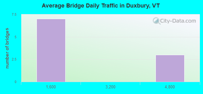
- 13,360Total average daily traffic
- 883Total average daily truck traffic
- 14,030Total future (year 2028) average daily traffic
- National Bridge Inventory (NBI) Registered Bridges for Duxbury
- No street view available for this location
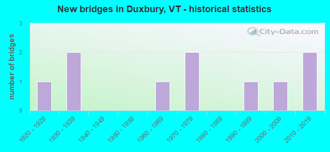
- New bridges - historical statistics
- 11920-1929
- 21930-1939
- 11960-1969
- 21970-1979
- 11990-1999
- 12000-2009
- 22010-2019
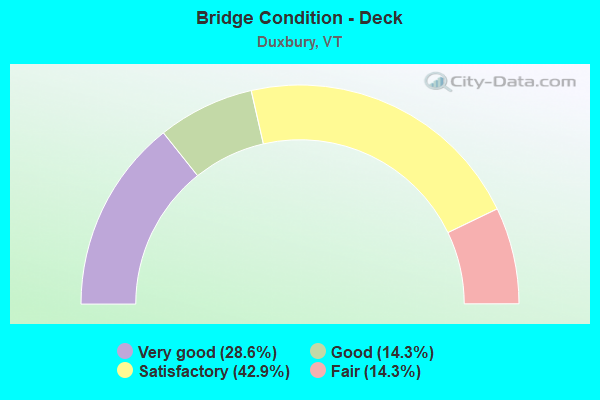
- Bridge Condition - Deck
- 28.6%Very good
- 14.3%Good
- 42.9%Satisfactory
- 14.3%Fair
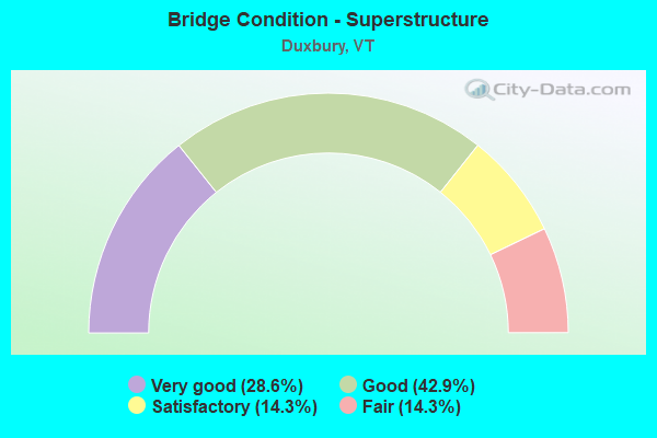
- Bridge Condition - Superstructure
- 28.6%Very good
- 42.9%Good
- 14.3%Satisfactory
- 14.3%Fair
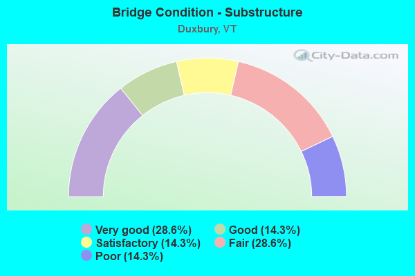
- Bridge Condition - Substructure
- 28.6%Very good
- 14.3%Good
- 14.3%Satisfactory
- 28.6%Fair
- 14.3%Poor
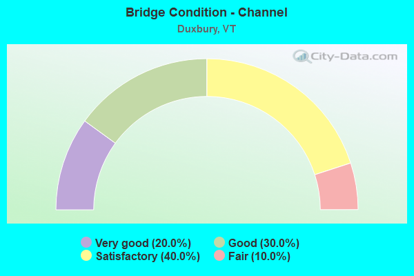
- Bridge Condition - Channel
- 20.0%Very good
- 30.0%Good
- 40.0%Satisfactory
- 10.0%Fair
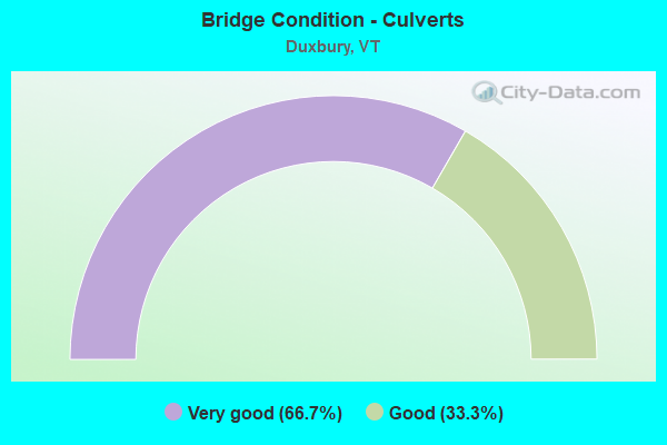
- Bridge Condition - Culverts
- 66.7%Very good
- 33.3%Good
Find on map >> Show street view
Structure Number: 101206000612061, Location: 0.2 MI TO JCT W CL3 TH12 (Lat: 44.357639, Lng: -72.826897), Route carried "on" structure: Other road C2001, Year Built: 1997, Status: Open, Structure Length: 1.65m (5.41ft), Average Daily Traffic: 370 (year 2019), Truck Traffic: 3%, Average Future Daily Traffic: 389 (year 2029), Design Load: HS 25 or greater, Features Intersected: RIDLEY BROOK
Minimum Vertical Clearance: 30+ m (98+ ft), Kilometerpoint: 0.000, Lanes on structure: 2, Owner: Town or Township Highway Agency, Approaching Roadway Width: 7.3m (24.0ft), Skew: 4 degrees, Material/Design: Steel, Design/Construction: Stringer/Multi-beam, Number Of Spans In Main Unit: 1, Length of Maximum Span: 15.5m (50.9ft), Curb or Sidewalk Widths: Left: 0.1m (0.3ft), Right: 0.1m (0.3ft), Curb-To-Curb Width: 7.1m (23.3ft), Out-to-Out Width: 7.9m (25.9ft)
Condition: Deck: Very good, Superstructure: Very good, Substructure: Good, Channel: Good, Operating Rating: 72.6 metric tons, Method Used To Determine Operating Rating: Allowable Stress (AS), Inventory Rating: 41.7 metric tons, Method Used To Determine Inventory Rating: Allowable Stress (AS), Structural Evaluation: Better than present minimum criteria, Deck Geometry: Meets minimum limits, Waterway Adequacy: Better than present minimum criteria, Approach Roadway Alignment: Equal to present desirable criteria, Designated Inspection Frequency: Every 24 months, Inspection Date: August 2020, Deck Structure Type: Concrete Cast-file-Place, Wearing Surface/Protective System: Wearing Surface: Bituminous, Membrane: Preformed Fabric, Deck Protection: Epoxy Coated Reinforcing
Find on map >> Show street view
Structure Number: 101206000712061, Location: 0.1 MI TO JCT W CL3 TH7 (Lat: 44.320903, Lng: -72.761044), Route carried "on" structure: Other road C3037, Year Built: 1974, Status: Open, Structure Length: 1.28m (4.20ft), Average Daily Traffic: 10 (year 2019), Truck Traffic: 2%, Average Future Daily Traffic: 11 (year 2029), Design Load: H 20, Features Intersected: CROSSETT BROOK
Minimum Vertical Clearance: 30+ m (98+ ft), Kilometerpoint: 0.000, Lanes on structure: 1, Owner: Town or Township Highway Agency, Approaching Roadway Width: 4.0m (13.1ft), Material/Design: Steel, Design/Construction: Stringer/Multi-beam, Number Of Spans In Main Unit: 1, Length of Maximum Span: 12.2m (40.0ft), Curb or Sidewalk Widths: Left: 0.2m (0.7ft), Right: 0.2m (0.7ft), Curb-To-Curb Width: 4.5m (14.8ft), Out-to-Out Width: 4.7m (15.4ft)
Condition: Deck: Fair, Superstructure: Good, Substructure: Very good, Channel: Satisfactory, Operating Rating: 20.9 metric tons, Method Used To Determine Operating Rating: Allowable Stress (AS), Inventory Rating: 15.4 metric tons, Method Used To Determine Inventory Rating: Allowable Stress (AS), Structural Evaluation: Meets minimum limits, Deck Geometry: Equal to present minimum criteria, Waterway Adequacy: Equal to present minimum criteria, Approach Roadway Alignment: Equal to present desirable criteria, Length Of Structure Improvement: 1.28m (4.20ft), Designated Inspection Frequency: Every 12 months, Inspection Date: April 2021, Bridge Improvement Cost: $225,000, Roadway Improvement Cost: $50,000, Total Project Cost: $275,000 ( Estimate for 2020), Deck Structure Type: Wood or Timber, Wearing Surface/Protective System: Wearing Surface: Wood or Timber, Deck Protection: Internally Sealed
Find on map >> Show street view
Structure Number: 101206003512061, Location: 0.1 MI S JCT TH14 (Lat: 44.321092, Lng: -72.782125), Route carried "on" structure: Other road C3004, Year Built: 2013, Status: Open, Structure Length: 0.73m (2.40ft), Average Daily Traffic: 130 (year 2019), Truck Traffic: 2%, Average Future Daily Traffic: 137 (year 2029), Design Load: HL 93, Features Intersected: CROSSETT BROOK
Minimum Vertical Clearance: 30+ m (98+ ft), Kilometerpoint: 0.000, Lanes on structure: 2, Owner: Town or Township Highway Agency, Approaching Roadway Width: 7.0m (23.0ft), Skew: 3 degrees, Material/Design: Steel, Design/Construction: Culvert, Number Of Spans In Main Unit: 1, Length of Maximum Span: 7.3m (24.0ft)
Condition: Channel: Good, Culverts: Very good, Operating Rating: 54.4 metric tons, Method Used To Determine Operating Rating: Field evaluation and documented engineering judgment, Inventory Rating: 32.7 metric tons, Method Used To Determine Inventory Rating: Field evaluation and documented engineering judgment, Structural Evaluation: Equal to present desirable criteria, Waterway Adequacy: Equal to present minimum criteria, Approach Roadway Alignment: Equal to present desirable criteria, Designated Inspection Frequency: Every 24 months, Inspection Date: August 2020
Find on map >> Show street view
Structure Number: 101206003712061, Location: 0.5 MI TO JCT W CL3 TH5 (Lat: 44.337650, Lng: -72.833061), Route carried "on" structure: Other road C3012, Year Built: 1967, Status: Open, Structure Length: 1.01m (3.31ft), Average Daily Traffic: 200 (year 2019), Truck Traffic: 2%, Average Future Daily Traffic: 210 (year 2029), Features Intersected: RIDLEY BROOK
Minimum Vertical Clearance: 30+ m (98+ ft), Kilometerpoint: 0.000, Lanes on structure: 2, Owner: Town or Township Highway Agency, Approaching Roadway Width: 6.1m (20.0ft), Skew: 1 degrees, Material/Design: Steel, Design/Construction: Stringer/Multi-beam, Number Of Spans In Main Unit: 1, Length of Maximum Span: 9.1m (29.9ft), Curb-To-Curb Width: 6.6m (21.7ft), Out-to-Out Width: 6.9m (22.6ft)
Condition: Deck: Satisfactory, Superstructure: Satisfactory, Substructure: Poor, Channel: Fair, Operating Rating: 61.7 metric tons, Method Used To Determine Operating Rating: Allowable Stress (AS), Inventory Rating: 41.7 metric tons, Method Used To Determine Inventory Rating: Allowable Stress (AS), Structural Evaluation: Meets minimum limits, Deck Geometry: Meets minimum limits, Waterway Adequacy: Equal to present minimum criteria, Approach Roadway Alignment: Equal to present minimum criteria, Length Of Structure Improvement: 1.62m (5.31ft), Designated Inspection Frequency: Every 12 months, Inspection Date: April 2021, Bridge Improvement Cost: $400,000, Roadway Improvement Cost: $150,000, Total Project Cost: $550,000 ( Estimate for 2020), Deck Structure Type: Concrete Precast Panels
Find on map >> Show street view
Structure Number: 101206003912061, Location: 0.01 MI TO JCT W CL3 TH6 (Lat: 44.328011, Lng: -72.835903), Route carried "on" structure: Other road C3012, Year Built: 1939, Status: Open, Structure Length: 1.95m (6.40ft), Average Daily Traffic: 150 (year 2019), Truck Traffic: 2%, Average Future Daily Traffic: 158 (year 2029), Design Load: H 15, Features Intersected: RIDLEY BROOK
Minimum Vertical Clearance: 30+ m (98+ ft), Kilometerpoint: 0.000, Lanes on structure: 2, Owner: Town or Township Highway Agency, Approaching Roadway Width: 7.3m (24.0ft), Skew: 4 degrees, Material/Design: Steel, Design/Construction: Stringer/Multi-beam, Number Of Spans In Main Unit: 1, Length of Maximum Span: 18.9m (62.0ft), Curb or Sidewalk Widths: Left: 0.1m (0.3ft), Right: 0.1m (0.3ft), Curb-To-Curb Width: 6.0m (19.7ft), Out-to-Out Width: 7.0m (23.0ft)
Condition: Deck: Satisfactory, Superstructure: Good, Substructure: Fair, Channel: Satisfactory, Operating Rating: 54.4 metric tons, Method Used To Determine Operating Rating: Allowable Stress (AS), Inventory Rating: 34.5 metric tons, Method Used To Determine Inventory Rating: Allowable Stress (AS), Structural Evaluation: Somewhat better than minimum adequacy, Deck Geometry: High priority of corrective action, Waterway Adequacy: Better than present minimum criteria, Approach Roadway Alignment: Equal to present desirable criteria, Length Of Structure Improvement: 1.95m (6.40ft), Designated Inspection Frequency: Every 24 months, Inspection Date: August 2020, Bridge Improvement Cost: $515,000, Roadway Improvement Cost: $50,000, Total Project Cost: $565,000 ( Estimate for 2020), Deck Structure Type: Concrete Cast-file-Place
Find on map >> Show street view
Structure Number: 101206004012061, Location: 0.18 MI TO JCT W CL3 TH6 (Lat: 44.331408, Lng: -72.836775), Route carried "on" structure: Other road C3012, Year Built: 1939, Status: Open, Structure Length: 1.95m (6.40ft), Average Daily Traffic: 200 (year 2019), Truck Traffic: 2%, Average Future Daily Traffic: 210 (year 2029), Design Load: H 15, Features Intersected: RIDLEY BROOK
Minimum Vertical Clearance: 30+ m (98+ ft), Kilometerpoint: 0.000, Lanes on structure: 2, Owner: Town or Township Highway Agency, Approaching Roadway Width: 7.3m (24.0ft), Skew: 3 degrees, Material/Design: Steel, Design/Construction: Stringer/Multi-beam, Number Of Spans In Main Unit: 1, Length of Maximum Span: 18.6m (61.0ft), Curb or Sidewalk Widths: Left: 0.1m (0.3ft), Right: 0.1m (0.3ft), Curb-To-Curb Width: 6.0m (19.7ft), Out-to-Out Width: 7.0m (23.0ft)
Condition: Deck: Good, Superstructure: Good, Substructure: Fair, Channel: Satisfactory, Operating Rating: 59.9 metric tons, Method Used To Determine Operating Rating: Allowable Stress (AS), Inventory Rating: 38.1 metric tons, Method Used To Determine Inventory Rating: Allowable Stress (AS), Structural Evaluation: Somewhat better than minimum adequacy, Deck Geometry: High priority of corrective action, Waterway Adequacy: Equal to present minimum criteria, Approach Roadway Alignment: Somewhat better than minimum adequacy, Length Of Structure Improvement: 1.95m (6.40ft), Designated Inspection Frequency: Every 24 months, Inspection Date: August 2020, Bridge Improvement Cost: $515,000, Roadway Improvement Cost: $50,000, Total Project Cost: $565,000 ( Estimate for 2020), Deck Structure Type: Concrete Cast-file-Place
Find on map >> Show street view
Structure Number: 101206004112061, Location: 0.02 MI TO JCT W CL3 TH5 (Lat: 44.341444, Lng: -72.833489), Route carried "on" structure: Other road C3012, Year Built: 1921, Year Reconstructed: 1938, Status: Open, Structure Length: 2.04m (6.69ft), Average Daily Traffic: 200 (year 2019), Truck Traffic: 2%, Average Future Daily Traffic: 210 (year 2029), Design Load: H 10, Features Intersected: RIDLEY BROOK
Minimum Vertical Clearance: 30+ m (98+ ft), Kilometerpoint: 0.000, Lanes on structure: 2, Owner: Town or Township Highway Agency, Approaching Roadway Width: 5.5m (18.0ft), Skew: 3 degrees, Material/Design: Steel, Design/Construction: Girder and Floorbeam System, Number Of Spans In Main Unit: 1, Length of Maximum Span: 19.2m (63.0ft), Curb or Sidewalk Widths: Left: 0.1m (0.3ft), Right: 0.1m (0.3ft), Curb-To-Curb Width: 5.2m (17.1ft), Out-to-Out Width: 5.5m (18.0ft)
Condition: Deck: Satisfactory, Superstructure: Fair, Substructure: Satisfactory, Channel: Satisfactory, Operating Rating: 38.1 metric tons, Method Used To Determine Operating Rating: Allowable Stress (AS), Inventory Rating: 24.5 metric tons, Method Used To Determine Inventory Rating: Allowable Stress (AS), Structural Evaluation: Somewhat better than minimum adequacy, Deck Geometry: High priority of replacement, Waterway Adequacy: Better than present minimum criteria, Approach Roadway Alignment: Somewhat better than minimum adequacy, Length Of Structure Improvement: 2.04m (6.69ft), Designated Inspection Frequency: Every 24 months, Critical Feature Inspection Frequency: Every 24 months, Inspection Date: August 2020, Critical Feature Inspection Date: August 2020, Bridge Improvement Cost: $424,000, Roadway Improvement Cost: $50,000, Total Project Cost: $474,000 ( Estimate for 2020), Deck Structure Type: Concrete Cast-file-Place
Find on map >> Show street view
Structure Number: 200013018712062, Location: 0.9 MI N JCT. VT.100B (Lat: 44.248956, Lng: -72.786217), Route carried "on" structure: State highway 100, Year Built: 2006, Status: Open, Structure Length: 2.10m (6.89ft), Average Daily Traffic: 3,900 (year 2018), Truck Traffic: 6%, Average Future Daily Traffic: 4,095 (year 2028), Design Load: HS 25 or greater, Features Intersected: DOWSVILLE BROOK
Minimum Vertical Clearance: 30+ m (98+ ft), Kilometerpoint: 218.951, Lanes on structure: 2, Base Highway Network: Yes (Inventory Route: 2300001, Subroute: 1), Owner: State Highway Agency, Approaching Roadway Width: 9.1m (29.9ft), Material/Design: Steel, Design/Construction: Stringer/Multi-beam, Number Of Spans In Main Unit: 1, Length of Maximum Span: 20.1m (65.9ft), Curb or Sidewalk Widths: Left: 0.2m (0.7ft), Right: 0.2m (0.7ft), Curb-To-Curb Width: 9.9m (32.5ft), Out-to-Out Width: 11.1m (36.4ft)
Condition: Deck: Very good, Superstructure: Very good, Substructure: Very good, Channel: Very good, Operating Rating: 63.5 metric tons, Method Used To Determine Operating Rating: Load Factor (LF), Inventory Rating: 38.1 metric tons, Method Used To Determine Inventory Rating: Load Factor (LF), Structural Evaluation: Equal to present desirable criteria, Deck Geometry: Meets minimum limits, Waterway Adequacy: Better than present minimum criteria, Approach Roadway Alignment: Equal to present desirable criteria, Designated Inspection Frequency: Every 24 months, Inspection Date: August 2021, Deck Structure Type: Concrete Cast-file-Place, Wearing Surface/Protective System: Wearing Surface: Bituminous, Membrane: Preformed Fabric, Deck Protection: Epoxy Coated Reinforcing
Find on map >> Show street view
Structure Number: 200013019312062, Location: 0.6 MI S JCT US 2 (Lat: 44.321592, Lng: -72.757678), Route carried "on" structure: State highway 100, Year Built: 2016, Status: Open, Structure Length: 1.46m (4.79ft), Average Daily Traffic: 3,900 (year 2018), Truck Traffic: 6%, Average Future Daily Traffic: 4,095 (year 2028), Design Load: HL 93, Features Intersected: CROSSETT BROOK
Minimum Vertical Clearance: 30+ m (98+ ft), Kilometerpoint: 227.672, Lanes on structure: 2, Base Highway Network: Yes (Inventory Route: 2300001, Subroute: 1), Owner: State Highway Agency, Approaching Roadway Width: 13.4m (44.0ft), Skew: 3 degrees, Material/Design: Concrete, Design/Construction: Culvert, Number Of Spans In Main Unit: 1, Length of Maximum Span: 14.6m (47.9ft)
Condition: Channel: Very good, Culverts: Very good, Operating Rating: 45.4 metric tons, Method Used To Determine Operating Rating: Load and Resistance Factor (LRFR), Inventory Rating: 34.5 metric tons, Method Used To Determine Inventory Rating: Load and Resistance Factor (LRFR), Structural Evaluation: Equal to present desirable criteria, Waterway Adequacy: Better than present minimum criteria, Approach Roadway Alignment: Equal to present desirable criteria, Designated Inspection Frequency: Every 24 months, Inspection Date: August 2021
Find on map >> Show street view
Structure Number: 200013019412062, Location: 0.2 MI S JCT US 2 (Lat: 44.325825, Lng: -72.746942), Route carried "on" structure: State highway 100, Year Built: 1977, Status: Open, Structure Length: 0.67m (2.20ft), Average Daily Traffic: 4,300 (year 2018), Truck Traffic: 9%, Average Future Daily Traffic: 4,515 (year 2028), Design Load: HS 20, Features Intersected: CROSSETT BROOK
Minimum Vertical Clearance: 30+ m (98+ ft), Kilometerpoint: 228.718, Lanes on structure: 2, Base Highway Network: Yes (Inventory Route: 2300001, Subroute: 1), Owner: State Highway Agency, Approaching Roadway Width: 13.4m (44.0ft), Material/Design: Concrete, Design/Construction: Culvert, Number Of Spans In Main Unit: 1, Length of Maximum Span: 6.1m (20.0ft), Curb or Sidewalk Widths: Left: 0.2m (0.7ft), Right: 0.2m (0.7ft)
Condition: Channel: Good, Culverts: Good, Operating Rating: 54.4 metric tons, Method Used To Determine Operating Rating: Field evaluation and documented engineering judgment, Inventory Rating: 32.7 metric tons, Method Used To Determine Inventory Rating: Field evaluation and documented engineering judgment, Structural Evaluation: Better than present minimum criteria, Waterway Adequacy: Better than present minimum criteria, Approach Roadway Alignment: Equal to present desirable criteria, Designated Inspection Frequency: Every 24 months, Inspection Date: August 2021, Deck Structure Type: Concrete Cast-file-Place, Wearing Surface/Protective System: Wearing Surface: Bituminous