Bridge Statistics for Easton, Pennsylvania (PA)
Condition, Traffic, Stress, Structural Evaluation, Project Costs
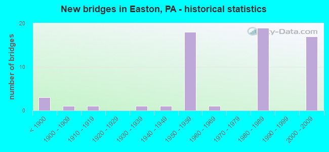
- New bridges - historical statistics
- 3Before 1900
- 11900-1909
- 11910-1919
- 11930-1939
- 11940-1949
- 181950-1959
- 11960-1969
- 191980-1989
- 172000-2009
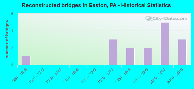
- Reconstructed bridges - Historical Statistics
- 11920-1929
- 01930-1939
- 01940-1949
- 01950-1959
- 01960-1969
- 31970-1979
- 21980-1989
- 21990-1999
- 52000-2009
- 32010-2019
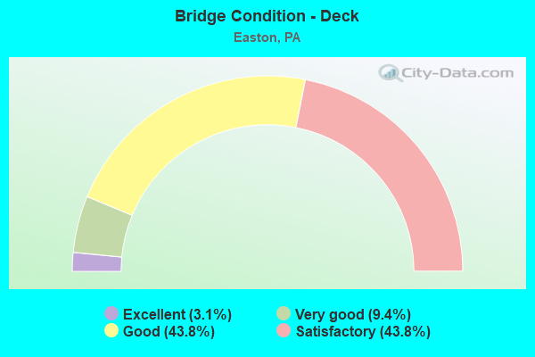
- Bridge Condition - Deck
- 3.1%Excellent
- 9.4%Very good
- 43.8%Good
- 43.8%Satisfactory
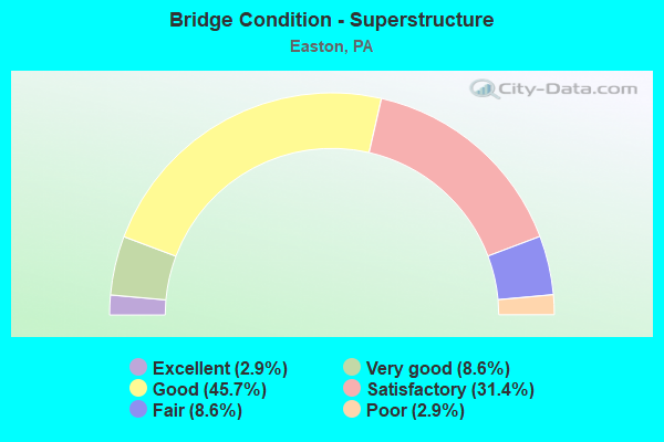
- Bridge Condition - Superstructure
- 2.9%Excellent
- 8.6%Very good
- 45.7%Good
- 31.4%Satisfactory
- 8.6%Fair
- 2.9%Poor
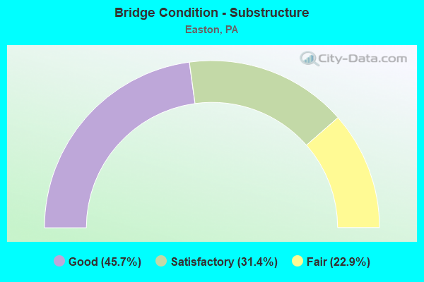
- Bridge Condition - Substructure
- 45.7%Good
- 31.4%Satisfactory
- 22.9%Fair
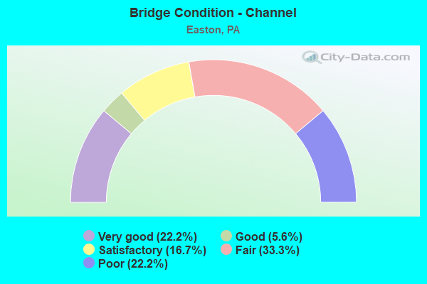
- Bridge Condition - Channel
- 22.2%Very good
- 5.6%Good
- 16.7%Satisfactory
- 33.3%Fair
- 22.2%Poor
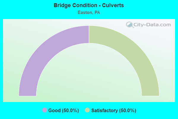
- Bridge Condition - Culverts
- 50.0%Good
- 50.0%Satisfactory
Find on map >> Show street view
Structure Number: 28488, Location: 13TH ST.INTERCHANGE (Lat: 40.695233, Lng: -75.228306), Route carried "under" structure: State highway , Year Built: 1954, Structure Length: 0. m, Average Daily Traffic: 13,682 (year 2021), Truck Traffic: 3%, Features Intersected: SR 2019 (LR 48021), Facility Carried by Structure: US 22
Minimum Vertical Clearance: 4.63m (15.19ft), Kilometerpoint: 0.431, Lanes on structure: 4, Lanes under structure: 2, Material/Design: Concrete, Design/Construction: Tee Beam, Length of Maximum Span: 18.0m (59.1ft)
Find on map >> Show street view
Structure Number: 28491, Location: 0.25 MI.W.PA.611 EXIT (Lat: 40.695944, Lng: -75.215439), Route carried "under" structure: ServiceOther road , Year Built: 1954, Structure Length: 0. m, Average Daily Traffic: 5 (year 1994), Truck Traffic: 1%, Features Intersected: BUSHKILL DR.,CEM. DR.,CK, Facility Carried by Structure: US 22(LR 773)
Minimum Vertical Clearance: 7.26m (23.82ft), Kilometerpoint: 0.000, Lanes on structure: 4, Lanes under structure: 4, Material/Design: Steel, Design/Construction: Girder and Floorbeam System, Length of Maximum Span: 36.6m (120.1ft)
Find on map >> Show street view
Structure Number: 28491, Location: 0.25 MI.W.PA.611 EXIT (Lat: 40.695944, Lng: -75.215439), Route carried "under" structure: City street LOCL, Year Built: 1954, Structure Length: 0. m, Average Daily Traffic: 1,250 (year 1994), Truck Traffic: 1%, Features Intersected: BUSHKILL DR.,CEM. DR.,CK, Facility Carried by Structure: US 22(LR 773)
Minimum Vertical Clearance: 4.19m (13.75ft), Kilometerpoint: 0.000, Lanes on structure: 4, Lanes under structure: 4, Material/Design: Steel, Design/Construction: Girder and Floorbeam System, Length of Maximum Span: 36.6m (120.1ft)
Find on map >> Show street view
Structure Number: 28492, Location: PA 611 EXIT (Lat: 40.694217, Lng: -75.212981), Route carried "under" structure: City street , Year Built: 1954, Structure Length: 0. m, Average Daily Traffic: 350 (year 1994), Truck Traffic: 1%, Features Intersected: BUSHKILL CREEK & DRIVE, Facility Carried by Structure: US 22 (LR 773)
Minimum Vertical Clearance: 4.54m (14.90ft), Kilometerpoint: 0.000, Lanes on structure: 4, Lanes under structure: 2, Material/Design: Steel continuous, Design/Construction: Stringer/Multi-beam, Length of Maximum Span: 25.6m (84.0ft)
Find on map >> Show street view
Structure Number: 28545, Location: OVER REDINGTON RD. (Lat: 40.631953, Lng: -75.278097), Route carried "under" structure: State highway , Year Built: 1987, Structure Length: 0. m, Average Daily Traffic: 276 (year 2021), Truck Traffic: 8%, Features Intersected: SR 2014(LR 48090), Facility Carried by Structure: SR 78EB(LR 1045)
Minimum Vertical Clearance: 5.36m (17.59ft), Kilometerpoint: 7.469, Lanes on structure: 2, Lanes under structure: 2, Material/Design: Prestressed concrete, Design/Construction: Box Beam or Girders - Multiple, Length of Maximum Span: 14.3m (46.9ft)
Find on map >> Show street view
Structure Number: 28549, Location: OVER ISLAND PK.RD. (Lat: 40.645617, Lng: -75.256889), Route carried "under" structure: State highway , Year Built: 1987, Structure Length: 0. m, Average Daily Traffic: 1,853 (year 2020), Truck Traffic: 7%, Features Intersected: SR 2012(LR 48010), Facility Carried by Structure: I-78 W.B.(LR 1045)
Minimum Vertical Clearance: 10.15m (33.30ft), Kilometerpoint: 8.352, Lanes on structure: 2, Lanes under structure: 2, Material/Design: Prestressed concrete, Design/Construction: Stringer/Multi-beam, Length of Maximum Span: 39.3m (128.9ft)
Find on map >> Show street view
Structure Number: 28709, Location: MORGAN HILL ROAD (Lat: 40.670097, Lng: -75.214397), Route carried "under" structure: Interstate 78, Year Built: 1985, Structure Length: 0. m, Average Daily Traffic: 53,400 (year 2020), Truck Traffic: 24%, Features Intersected: I-78(TOLL RD.DRJTBC), Facility Carried by Structure: SR 2005
Minimum Vertical Clearance: 5.18m (16.99ft), Kilometerpoint: 121.425, Lanes on structure: 4, Lanes under structure: 4, Material/Design: Prestressed concrete continuous, Design/Construction: Box Beam or Girders - Single/Spread, Length of Maximum Span: 33.2m (108.9ft)
Find on map >> Show street view
Structure Number: 28719, Location: APPLEBUTTER RD. OVER I-78 (Lat: 40.624344, Lng: -75.282753), Route carried "under" structure: Interstate 78, Year Built: 1987, Structure Length: 0. m, Average Daily Traffic: 35,449 (year 2021), Truck Traffic: 13%, Features Intersected: SR 78(LR 1045), Facility Carried by Structure: SR 2012 (LR 48010)
Minimum Vertical Clearance: 12.98m (42.59ft), Kilometerpoint: 11.207, Lanes on structure: 2, Lanes under structure: 5, Material/Design: Steel continuous, Design/Construction: Stringer/Multi-beam, Length of Maximum Span: 50.0m (164.0ft)
Find on map >> Show street view
Structure Number: 28719, Location: APPLEBUTTER RD. OVER I-78 (Lat: 40.624344, Lng: -75.282753), Route carried "under" structure: Interstate 78, Year Built: 1987, Structure Length: 0. m, Average Daily Traffic: 34,942 (year 2021), Truck Traffic: 20%, Features Intersected: SR 78(LR 1045), Facility Carried by Structure: SR 2012 (LR 48010)
Minimum Vertical Clearance: 10.71m (35.14ft), Kilometerpoint: 11.230, Lanes on structure: 2, Lanes under structure: 5, Material/Design: Steel continuous, Design/Construction: Stringer/Multi-beam, Length of Maximum Span: 50.0m (164.0ft)
Find on map >> Show street view
Structure Number: 28728, Location: CEDARVILLE RD. (Lat: 40.676097, Lng: -75.194197), Route carried "under" structure: Interstate 78, Year Built: 1985, Structure Length: 0. m, Average Daily Traffic: 53,400 (year 2020), Truck Traffic: 24%, Features Intersected: I-78, Facility Carried by Structure: SR 2016(LR 48121)
Minimum Vertical Clearance: 6.40m (21.00ft), Kilometerpoint: 123.195, Lanes on structure: 2, Lanes under structure: 6, Material/Design: Prestressed concrete, Design/Construction: Stringer/Multi-beam, Length of Maximum Span: 34.1m (111.9ft)
Find on map >> Show street view
Structure Number: 28729, Location: 13TH ST.INTERCHANGE (Lat: 40.694839, Lng: -75.230297), Route carried "under" structure: US 22, Year Built: 1954, Structure Length: 0. m, Average Daily Traffic: 16,689 (year 2022), Truck Traffic: 5%, Features Intersected: SR 22 (LR 773), Facility Carried by Structure: SR 2017 (LR 48019)
Minimum Vertical Clearance: 4.42m (14.50ft), Kilometerpoint: 16.282, Lanes on structure: 4, Lanes under structure: 4, Material/Design: Steel, Design/Construction: Stringer/Multi-beam, Length of Maximum Span: 28.3m (92.8ft)
Find on map >> Show street view
Structure Number: 28729, Location: 13TH ST.INTERCHANGE (Lat: 40.694839, Lng: -75.230297), Route carried "under" structure: US 22, Year Built: 1954, Structure Length: 0. m, Average Daily Traffic: 13,784 (year 2020), Truck Traffic: 6%, Features Intersected: SR 22 (LR 773), Facility Carried by Structure: SR 2017 (LR 48019)
Minimum Vertical Clearance: 4.63m (15.19ft), Kilometerpoint: 16.319, Lanes on structure: 4, Lanes under structure: 4, Material/Design: Steel, Design/Construction: Stringer/Multi-beam, Length of Maximum Span: 28.3m (92.8ft)
Find on map >> Show street view
Structure Number: 28916, Location: CITY OF EASTON (Lat: 40.695000, Lng: -75.204997), Route carried "under" structure: State highway 611, Year Built: 1950, Structure Length: 0. m, Average Daily Traffic: 4,137 (year 2020), Truck Traffic: 5%, Features Intersected: PA 611(SR0611), Facility Carried by Structure: US 22
Minimum Vertical Clearance: 4.88m (16.01ft), Kilometerpoint: 12.405, Lanes on structure: 4, Lanes under structure: 2, Material/Design: Steel, Design/Construction: Stringer/Multi-beam, Length of Maximum Span: 10.1m (33.1ft)
Find on map >> Show street view
Structure Number: 28917, Location: CITY OF EASTON (Lat: 40.694447, Lng: -75.209392), Route carried "under" structure: State highway , Year Built: 1950, Structure Length: 0. m, Average Daily Traffic: 12,331 (year 2022), Truck Traffic: 2%, Features Intersected: N. 3RD ST (SR 2023), Facility Carried by Structure: US 22
Minimum Vertical Clearance: 5.21m (17.09ft), Kilometerpoint: 0.000, Lanes on structure: 4, Lanes under structure: 4, Material/Design: Steel, Design/Construction: Stringer/Multi-beam, Length of Maximum Span: 25.3m (83.0ft)
Find on map >> Show street view
Structure Number: 41043, Location: W.B.OVER REDINGTON RD. (Lat: 40.632061, Lng: -75.278469), Route carried "under" structure: State highway , Year Built: 2000, Structure Length: 0. m, Average Daily Traffic: 276 (year 2021), Truck Traffic: 8%, Features Intersected: SR 2014(LR 48090), Facility Carried by Structure: I-78 WB (LR 1045)
Minimum Vertical Clearance: 6.64m (21.78ft), Kilometerpoint: 7.469, Lanes on structure: 4, Lanes under structure: 2, Material/Design: Prestressed concrete, Design/Construction: Stringer/Multi-beam, Length of Maximum Span: 25.9m (85.0ft)
Find on map >> Show street view
Structure Number: 41127, Location: W.B.OVER SR 8018 (Lat: 40.638975, Lng: -75.272231), Route carried "under" structure: Ramp State highway , Year Built: 2001, Structure Length: 0. m, Average Daily Traffic: 9,443 (year 2021), Truck Traffic: 8%, Features Intersected: RAMPS A&B SR8018, Facility Carried by Structure: I-78 WB (LR 1045)
Minimum Vertical Clearance: 10.15m (33.30ft), Kilometerpoint: 0.000, Lanes on structure: 3, Lanes under structure: 1, Material/Design: Prestressed concrete, Design/Construction: Stringer/Multi-beam, Length of Maximum Span: 39.9m (130.9ft)
Find on map >> Show street view
Structure Number: 41127, Location: W.B.OVER SR 8018 (Lat: 40.638975, Lng: -75.272231), Route carried "under" structure: Ramp State highway , Year Built: 2001, Structure Length: 0. m, Average Daily Traffic: 9,229 (year 2021), Truck Traffic: 8%, Features Intersected: RAMPS A&B SR8018, Facility Carried by Structure: I-78 WB (LR 1045)
Minimum Vertical Clearance: 9.05m (29.69ft), Kilometerpoint: 0.000, Lanes on structure: 3, Lanes under structure: 1, Material/Design: Prestressed concrete, Design/Construction: Stringer/Multi-beam, Length of Maximum Span: 39.9m (130.9ft)
Find on map >> Show street view
Structure Number: 41283, Location: E.B. OVER SR 8018 (Lat: 40.638533, Lng: -75.272386), Route carried "under" structure: Ramp State highway , Year Built: 2001, Structure Length: 0. m, Average Daily Traffic: 9,443 (year 2021), Truck Traffic: 8%, Features Intersected: RAMPS A&B SR 8018, Facility Carried by Structure: I-78 EB (LR 1045)
Minimum Vertical Clearance: 7.59m (24.90ft), Kilometerpoint: 0.000, Lanes on structure: 3, Lanes under structure: 1, Material/Design: Prestressed concrete, Design/Construction: Stringer/Multi-beam, Length of Maximum Span: 39.9m (130.9ft)
Find on map >> Show street view
Structure Number: 41283, Location: E.B. OVER SR 8018 (Lat: 40.638533, Lng: -75.272386), Route carried "under" structure: Ramp State highway , Year Built: 2001, Structure Length: 0. m, Average Daily Traffic: 9,229 (year 2021), Truck Traffic: 8%, Features Intersected: RAMPS A&B SR 8018, Facility Carried by Structure: I-78 EB (LR 1045)
Minimum Vertical Clearance: 6.06m (19.88ft), Kilometerpoint: 0.000, Lanes on structure: 3, Lanes under structure: 1, Material/Design: Prestressed concrete, Design/Construction: Stringer/Multi-beam, Length of Maximum Span: 39.9m (130.9ft)
Find on map >> Show street view
Structure Number: 41299, Location: OVER HOPE ROAD (Lat: 40.648514, Lng: -75.284089), Route carried "under" structure: State highway , Year Built: 2001, Structure Length: 0. m, Average Daily Traffic: 122 (year 2019), Truck Traffic: 5%, Features Intersected: SR 2007, Facility Carried by Structure: PA 33 NB
Minimum Vertical Clearance: 10.18m (33.40ft), Kilometerpoint: 0.000, Lanes on structure: 2, Lanes under structure: 2, Material/Design: Steel, Design/Construction: Stringer/Multi-beam, Length of Maximum Span: 73.2m (240.2ft)
Find on map >> Show street view
Structure Number: 413, Location: OVER HOPE ROAD (Lat: 40.648281, Lng: -75.284278), Route carried "under" structure: State highway , Year Built: 2001, Structure Length: 0. m, Average Daily Traffic: 122 (year 2019), Truck Traffic: 5%, Features Intersected: SR 2007, Facility Carried by Structure: PA 33 SB
Minimum Vertical Clearance: 11.22m (36.81ft), Kilometerpoint: 0.000, Lanes on structure: 2, Lanes under structure: 2, Material/Design: Steel, Design/Construction: Stringer/Multi-beam, Length of Maximum Span: 73.2m (240.2ft)
Find on map >> Show street view
Structure Number: 41306, Location: FREEMANSBURG AVE INTER. (Lat: 40.652794, Lng: -75.287356), Route carried "under" structure: State highway 33, Year Built: 2001, Structure Length: 0. m, Average Daily Traffic: 31,228 (year 2022), Truck Traffic: 18%, Features Intersected: PA 33, Facility Carried by Structure: SR 2018
Minimum Vertical Clearance: 5.51m (18.08ft), Kilometerpoint: 1.790, Lanes on structure: 5, Lanes under structure: 5, Design/Construction: Stringer/Multi-beam, Length of Maximum Span: 25.9m (85.0ft)
Find on map >> Show street view
Structure Number: 41306, Location: FREEMANSBURG AVE INTER. (Lat: 40.652794, Lng: -75.287356), Route carried "under" structure: State highway 33, Year Built: 2001, Structure Length: 0. m, Average Daily Traffic: 31,053 (year 2022), Truck Traffic: 19%, Features Intersected: PA 33, Facility Carried by Structure: SR 2018
Minimum Vertical Clearance: 5.28m (17.32ft), Kilometerpoint: 1.846, Lanes on structure: 5, Lanes under structure: 5, Design/Construction: Stringer/Multi-beam, Length of Maximum Span: 25.9m (85.0ft)
Find on map >> Show street view
Structure Number: 45614, Location: 0.25 MI NW OF DELAWARE R. (Lat: 40.675600, Lng: -75.180800), Route carried "under" structure: State highway 611, Year Built: 1986, Structure Length: 0. m, Average Daily Traffic: 3,100 (year 2020), Truck Traffic: 8%, Features Intersected: SR 611, Facility Carried by Structure: I-78 WB
Minimum Vertical Clearance: 7.59m (24.90ft), Kilometerpoint: 9.151, Lanes on structure: 3, Lanes under structure: 2, Material/Design: Prestressed concrete, Design/Construction: Box Beam or Girders - Single/Spread, Length of Maximum Span: 24.7m (81.0ft)
Find on map >> Show street view
Structure Number: 45615, Location: 0.24 MI NW OF DELAWARE R. (Lat: 40.675300, Lng: -75.181100), Route carried "under" structure: State highway 611, Year Built: 1986, Structure Length: 0. m, Average Daily Traffic: 3,100 (year 2020), Truck Traffic: 8%, Features Intersected: SR 611, Facility Carried by Structure: I-78 EB
Minimum Vertical Clearance: 8.60m (28.22ft), Kilometerpoint: 9.151, Lanes on structure: 3, Lanes under structure: 2, Material/Design: Prestressed concrete, Design/Construction: Box Beam or Girders - Single/Spread, Length of Maximum Span: 21.0m (68.9ft)