Bridge Statistics for Elkridge, Maryland (MD)
Condition, Traffic, Stress, Structural Evaluation, Project Costs
- National Bridge Inventory (NBI) Statistics
- 57Number of bridges
- 1,060ft / 323mTotal length
- $4,899,000Total costs
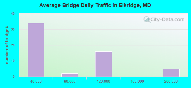
- 2,739,215Total average daily traffic
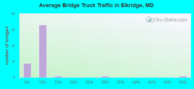
- 148,084Total average daily truck traffic
- National Bridge Inventory (NBI) Registered Bridges for Elkridge
- No street view available for this location
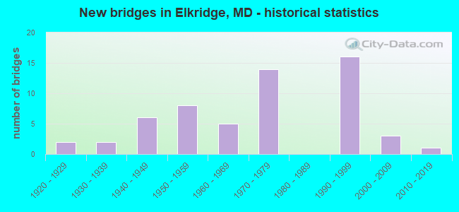
- New bridges - historical statistics
- 21920-1929
- 21930-1939
- 61940-1949
- 81950-1959
- 51960-1969
- 141970-1979
- 161990-1999
- 32000-2009
- 12010-2019
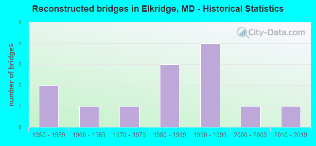
- Reconstructed bridges - Historical Statistics
- 21950-1959
- 11960-1969
- 11970-1979
- 31980-1989
- 41990-1999
- 12000-2009
- 12010-2019
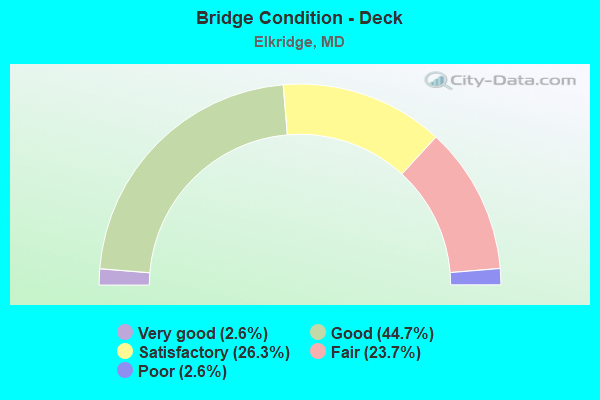
- Bridge Condition - Deck
- 2.6%Very good
- 44.7%Good
- 26.3%Satisfactory
- 23.7%Fair
- 2.6%Poor
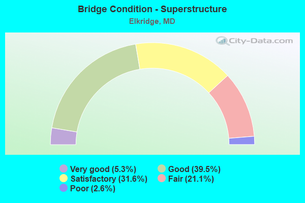
- Bridge Condition - Superstructure
- 5.3%Very good
- 39.5%Good
- 31.6%Satisfactory
- 21.1%Fair
- 2.6%Poor
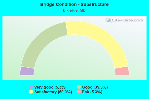
- Bridge Condition - Substructure
- 5.3%Very good
- 39.5%Good
- 50.0%Satisfactory
- 5.3%Fair
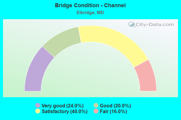
- Bridge Condition - Channel
- 24.0%Very good
- 20.0%Good
- 40.0%Satisfactory
- 16.0%Fair
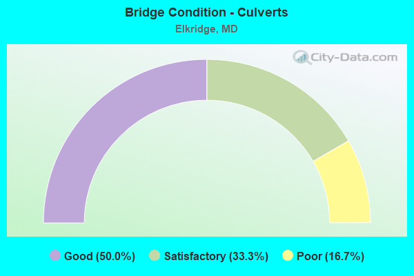
- Bridge Condition - Culverts
- 50.0%Good
- 33.3%Satisfactory
- 16.7%Poor
Find on map >> Show street view
Structure Number: 100000020020041, Location: 0.43 M N OF BR NO 0202100 (Lat: 39.187369, Lng: -76.715278), Route carried "on" structure: State highway 295, Year Built: 1950, Status: Open, Structure Length: 1.25m (4.10ft), Average Daily Traffic: 42,696 (year 2006), Truck Traffic: 8%, Average Future Daily Traffic: 49,228 (year 2026), Design Load: HS 20, Features Intersected: HANOVER ROAD
Minimum Vertical Clearance: 30+ m (98+ ft), Kilometerpoint: 16.718, Lanes on structure: 2, Lanes under structure: 2, Base Highway Network: Yes, Owner: State Highway Agency, Approaching Roadway Width: 12.2m (40.0ft), Material/Design: Concrete, Design/Construction: Frame, Number Of Spans In Main Unit: 1, Length of Maximum Span: 11.0m (36.1ft), Curb-To-Curb Width: 15.2m (49.9ft), Out-to-Out Width: 16.6m (54.5ft)
Condition: Deck: Satisfactory, Superstructure: Satisfactory, Substructure: Satisfactory, Operating Rating: 46.7 metric tons, Method Used To Determine Operating Rating: Load Factor (LF), Inventory Rating: 28.1 metric tons, Method Used To Determine Inventory Rating: Load Factor (LF), Structural Evaluation: Equal to present minimum criteria, Deck Geometry: Superior to present desirable criteria, Underclear: Meets minimum limits, Approach Roadway Alignment: Equal to present minimum criteria, Designated Inspection Frequency: Every 24 months, Inspection Date: April 2021, Deck Structure Type: Concrete Cast-file-Place, Wearing Surface/Protective System: Wearing Surface: Bituminous
Find on map >> Show street view
Structure Number: 100000020020042, Location: 0.43 M N OF BR NO 0202100 (Lat: 39.187683, Lng: -76.715578), Route carried "on" structure: State highway 295, Year Built: 1950, Status: Open, Structure Length: 1.25m (4.10ft), Average Daily Traffic: 42,696 (year 2006), Truck Traffic: 8%, Average Future Daily Traffic: 49,228 (year 2026), Design Load: HS 20, Features Intersected: HANOVER ROAD
Minimum Vertical Clearance: 30+ m (98+ ft), Kilometerpoint: 16.711, Lanes on structure: 2, Lanes under structure: 2, Base Highway Network: Yes, Owner: State Highway Agency, Approaching Roadway Width: 12.2m (40.0ft), Material/Design: Concrete, Design/Construction: Frame, Number Of Spans In Main Unit: 1, Length of Maximum Span: 11.0m (36.1ft), Curb-To-Curb Width: 15.2m (49.9ft), Out-to-Out Width: 16.6m (54.5ft)
Condition: Deck: Satisfactory, Superstructure: Satisfactory, Substructure: Satisfactory, Operating Rating: 46.7 metric tons, Method Used To Determine Operating Rating: Load Factor (LF), Inventory Rating: 28.1 metric tons, Method Used To Determine Inventory Rating: Load Factor (LF), Structural Evaluation: Equal to present minimum criteria, Deck Geometry: Superior to present desirable criteria, Underclear: Meets minimum limits, Approach Roadway Alignment: Equal to present desirable criteria, Designated Inspection Frequency: Every 24 months, Inspection Date: April 2021, Deck Structure Type: Concrete Cast-file-Place, Wearing Surface/Protective System: Wearing Surface: Bituminous
Find on map >> Show street view
Structure Number: 10000002002102, Location: 0.43 M S OF BR NO 0202000 (Lat: 39.182369, Lng: -76.719786), Route carried "on" structure: State highway 295, Year Built: 1950, Status: Open, Structure Length: 0.88m (2.89ft), Average Daily Traffic: 88,882 (year 2009), Truck Traffic: 8%, Average Future Daily Traffic: 98,457 (year 2026), Design Load: HS 20, Features Intersected: PINEY RUN
Minimum Vertical Clearance: 30+ m (98+ ft), Kilometerpoint: 16.026, Lanes on structure: 4, Base Highway Network: Yes, Owner: State Highway Agency, Approaching Roadway Width: 51.5m (169.0ft), Skew: 3 degrees, Material/Design: Concrete, Design/Construction: Culvert, Length of Maximum Span: 4.3m (14.1ft)
Condition: Channel: Fair, Culverts: Satisfactory, Structural Evaluation: Equal to present minimum criteria, Waterway Adequacy: Equal to present desirable criteria, Approach Roadway Alignment: Equal to present desirable criteria, Designated Inspection Frequency: Every 24 months, Inspection Date: April 2020
Find on map >> Show street view
Structure Number: 10000002004901, Location: 0.16 MI S OF HOWARD CO (Lat: 39.177611, Lng: -76.744606), Route carried "on" structure: State highway 176, Year Built: 1949, Status: Open, Structure Length: 0.76m (2.49ft), Average Daily Traffic: 8,191 (year 2009), Truck Traffic: 8%, Average Future Daily Traffic: 10,470 (year 2026), Design Load: H 20, Features Intersected: BRANCH OF DEEP RUN, Facility Carried by Structure: MD 103
Minimum Vertical Clearance: 30+ m (98+ ft), Kilometerpoint: 1.078, Lanes on structure: 2, Owner: State Highway Agency, Approaching Roadway Width: 13.4m (44.0ft), Skew: 3 degrees, Material/Design: Concrete, Design/Construction: Tee Beam, Number Of Spans In Main Unit: 1, Length of Maximum Span: 6.7m (22.0ft), Curb or Sidewalk Widths: Left: 1.6m (5.2ft), Right: 1.6m (5.2ft), Curb-To-Curb Width: 13.4m (44.0ft), Out-to-Out Width: 16.5m (54.1ft)
Condition: Deck: Fair, Superstructure: Fair, Substructure: Satisfactory, Channel: Satisfactory, Operating Rating: 49.0 metric tons, Method Used To Determine Operating Rating: Load Factor (LF), Inventory Rating: 29.5 metric tons, Method Used To Determine Inventory Rating: Load Factor (LF), Structural Evaluation: Somewhat better than minimum adequacy, Deck Geometry: Equal to present minimum criteria, Waterway Adequacy: Superior to present desirable criteria, Approach Roadway Alignment: Equal to present desirable criteria, Designated Inspection Frequency: Every 12 months, Inspection Date: January 2022, Deck Structure Type: Concrete Cast-file-Place, Wearing Surface/Protective System: Wearing Surface: Bituminous
Find on map >> Show street view
Structure Number: 100000020129013, Location: 0.96 MI N OF MD 295 (Lat: 39.211372, Lng: -76.694586), Route carried "on" structure: Interstate 195, Year Built: 1990, Status: Open, Structure Length: 67.21m (220.51ft), Average Daily Traffic: 39,015 (year 2009), Truck Traffic: 8%, Average Future Daily Traffic: 22,432 (year 2026), Design Load: HS 20+Mod, Features Intersected: AMTRAK, PATAPSCO RIVER
Minimum Vertical Clearance: 30+ m (98+ ft), Kilometerpoint: 3.760, Lanes on structure: 2, Lanes under structure: 2, Base Highway Network: Yes, Owner: State Highway Agency, Approaching Roadway Width: 14.0m (45.9ft), Skew: 9 degrees, Material/Design: Steel continuous, Design/Construction: Stringer/Multi-beam, Number Of Spans In Main Unit: 15, Length of Maximum Span: 74.7m (245.1ft), Curb-To-Curb Width: 12.2m (40.0ft), Out-to-Out Width: 12.3m (40.4ft)
Condition: Deck: Good, Superstructure: Satisfactory, Substructure: Satisfactory, Channel: Very good, Operating Rating: 75.7 metric tons, Method Used To Determine Operating Rating: Load Factor (LF), Inventory Rating: 45.4 metric tons, Method Used To Determine Inventory Rating: Load Factor (LF), Structural Evaluation: Equal to present minimum criteria, Deck Geometry: Better than present minimum criteria, Underclear: Better than present minimum criteria, Waterway Adequacy: Equal to present desirable criteria, Approach Roadway Alignment: Equal to present desirable criteria, Designated Inspection Frequency: Every 24 months, Inspection Date: January 2021, Deck Structure Type: Concrete Cast-file-Place, Wearing Surface/Protective System: Wearing Surface: Monolithic Concrete, Deck Protection: Epoxy Coated Reinforcing
Find on map >> Show street view
Structure Number: 10000002017001, Location: HOWARD COUNTY LINE (Lat: 39.179825, Lng: -76.736731), Route carried "on" structure: State highway 100M, Year Built: 1996, Status: Open, Structure Length: 9.45m (31.00ft), Average Daily Traffic: 9,784 (year 2006), Truck Traffic: 8%, Average Future Daily Traffic: 11,281 (year 2026), Design Load: HS 20, Features Intersected: DEEP RUN
Minimum Vertical Clearance: 30+ m (98+ ft), Kilometerpoint: 0.547, Lanes on structure: 4, Owner: State Highway Agency, Approaching Roadway Width: 16.5m (54.1ft), Material/Design: Steel continuous, Design/Construction: Stringer/Multi-beam, Number Of Spans In Main Unit: 2, Length of Maximum Span: 46.3m (151.9ft), Curb-To-Curb Width: 16.5m (54.1ft), Out-to-Out Width: 17.7m (58.1ft)
Condition: Deck: Satisfactory, Superstructure: Good, Substructure: Good, Channel: Very good, Operating Rating: 82.5 metric tons, Method Used To Determine Operating Rating: Load Factor (LF), Inventory Rating: 49.4 metric tons, Method Used To Determine Inventory Rating: Load Factor (LF), Structural Evaluation: Better than present minimum criteria, Deck Geometry: Meets minimum limits, Waterway Adequacy: Equal to present desirable criteria, Approach Roadway Alignment: Equal to present desirable criteria, Designated Inspection Frequency: Every 24 months, Inspection Date: May 2021, Deck Structure Type: Concrete Cast-file-Place, Wearing Surface/Protective System: Wearing Surface: Monolithic Concrete, Deck Protection: Epoxy Coated Reinforcing
Find on map >> Show street view
Structure Number: 100000020178013, Location: ON HOWARD COUNTY LINE (Lat: 39.180697, Lng: -76.742897), Route carried "on" structure: State highway 100, Year Built: 1996, Status: Open, Structure Length: 26.15m (85.79ft), Average Daily Traffic: 83,402 (year 2009), Truck Traffic: 8%, Average Future Daily Traffic: 50,515 (year 2026), Design Load: HS 20, Features Intersected: DEEP RUN
Minimum Vertical Clearance: 30+ m (98+ ft), Kilometerpoint: 11.903, Lanes on structure: 3, Base Highway Network: Yes, Owner: State Highway Agency, Approaching Roadway Width: 15.2m (49.9ft), Skew: 9 degrees, Material/Design: Steel continuous, Design/Construction: Stringer/Multi-beam, Number Of Spans In Main Unit: 5, Length of Maximum Span: 73.2m (240.2ft), Curb-To-Curb Width: 15.2m (49.9ft), Out-to-Out Width: 16.5m (54.1ft)
Condition: Deck: Satisfactory, Superstructure: Good, Substructure: Good, Channel: Very good, Operating Rating: 70.7 metric tons, Method Used To Determine Operating Rating: Load Factor (LF), Inventory Rating: 42.6 metric tons, Method Used To Determine Inventory Rating: Load Factor (LF), Structural Evaluation: Better than present minimum criteria, Deck Geometry: Meets minimum limits, Waterway Adequacy: Superior to present desirable criteria, Approach Roadway Alignment: Equal to present desirable criteria, Designated Inspection Frequency: Every 24 months, Inspection Date: April 2020, Deck Structure Type: Concrete Cast-file-Place, Wearing Surface/Protective System: Wearing Surface: Monolithic Concrete, Deck Protection: Epoxy Coated Reinforcing
Find on map >> Show street view
Structure Number: 100000020178014, Location: ON HOWARD COUNTY LINE (Lat: 39.179172, Lng: -76.740572), Route carried "on" structure: State highway 100, Year Built: 1996, Status: Open, Structure Length: 26.15m (85.79ft), Average Daily Traffic: 83,402 (year 2009), Truck Traffic: 8%, Average Future Daily Traffic: 50,515 (year 2026), Design Load: HS 20, Features Intersected: DEEP RUN
Minimum Vertical Clearance: 30+ m (98+ ft), Kilometerpoint: 11.903, Lanes on structure: 3, Base Highway Network: Yes, Owner: State Highway Agency, Approaching Roadway Width: 15.2m (49.9ft), Skew: 9 degrees, Material/Design: Steel continuous, Design/Construction: Stringer/Multi-beam, Number Of Spans In Main Unit: 5, Length of Maximum Span: 73.2m (240.2ft), Curb-To-Curb Width: 15.2m (49.9ft), Out-to-Out Width: 16.5m (54.1ft)
Condition: Deck: Satisfactory, Superstructure: Good, Substructure: Good, Channel: Good, Operating Rating: 70.3 metric tons, Method Used To Determine Operating Rating: Load Factor (LF), Inventory Rating: 42.2 metric tons, Method Used To Determine Inventory Rating: Load Factor (LF), Structural Evaluation: Better than present minimum criteria, Deck Geometry: Meets minimum limits, Waterway Adequacy: Superior to present desirable criteria, Approach Roadway Alignment: Equal to present desirable criteria, Designated Inspection Frequency: Every 24 months, Inspection Date: April 2020, Deck Structure Type: Concrete Cast-file-Place, Wearing Surface/Protective System: Wearing Surface: Monolithic Concrete, Deck Protection: Epoxy Coated Reinforcing
Find on map >> Show street view
Structure Number: 10000002017901, Location: 0.13 MILE NORTH OF MD 103 (Lat: 39.178303, Lng: -76.738317), Route carried "on" structure: State highway 100M, Year Built: 1996, Status: Open, Structure Length: 6.25m (20.51ft), Average Daily Traffic: 9,784 (year 0006), Truck Traffic: 8%, Average Future Daily Traffic: 11,281 (year 0026), Design Load: HS 20, Features Intersected: MD 100
Minimum Vertical Clearance: 30+ m (98+ ft), Kilometerpoint: 0.209, Lanes on structure: 4, Lanes under structure: 4, Owner: State Highway Agency, Approaching Roadway Width: 18.9m (62.0ft), Material/Design: Steel continuous, Design/Construction: Stringer/Multi-beam, Number Of Spans In Main Unit: 2, Length of Maximum Span: 32.9m (107.9ft), Curb-To-Curb Width: 18.9m (62.0ft), Out-to-Out Width: 20.1m (65.9ft)
Condition: Deck: Good, Superstructure: Good, Substructure: Good, Operating Rating: 70.7 metric tons, Method Used To Determine Operating Rating: Load Factor (LF), Inventory Rating: 42.2 metric tons, Method Used To Determine Inventory Rating: Load Factor (LF), Structural Evaluation: Better than present minimum criteria, Deck Geometry: Equal to present minimum criteria, Underclear: Somewhat better than minimum adequacy, Approach Roadway Alignment: Equal to present desirable criteria, Designated Inspection Frequency: Every 24 months, Inspection Date: Febuary 2020, Deck Structure Type: Concrete Cast-file-Place, Wearing Surface/Protective System: Wearing Surface: Monolithic Concrete, Deck Protection: Epoxy Coated Reinforcing
Find on map >> Show street view
Structure Number: 10000002021801, Location: 0.46 MI S OF IS 195 (Lat: 39.197997, Lng: -76.702653), Route carried "on" structure: County highway 582, Year Built: 1950, Year Reconstructed: 2012, Status: Open, Structure Length: 1.97m (6.46ft), Average Daily Traffic: 1,100 (year 2009), Truck Traffic: 5%, Average Future Daily Traffic: 1,287 (year 2026), Features Intersected: MD 295 SBR, Facility Carried by Structure: RIDGE ROAD
Minimum Vertical Clearance: 30+ m (98+ ft), Kilometerpoint: 4.727, Lanes on structure: 2, Lanes under structure: 2, Owner: State Highway Agency, Approaching Roadway Width: 10.1m (33.1ft), Skew: 2 degrees, Material/Design: Steel, Design/Construction: Stringer/Multi-beam, Number Of Spans In Main Unit: 1, Length of Maximum Span: 18.3m (60.0ft), Curb-To-Curb Width: 12.8m (42.0ft), Out-to-Out Width: 14.0m (45.9ft)
Condition: Deck: Good, Superstructure: Satisfactory, Substructure: Satisfactory, Operating Rating: 82.5 metric tons, Method Used To Determine Operating Rating: Load Factor (LF), Inventory Rating: 49.4 metric tons, Method Used To Determine Inventory Rating: Load Factor (LF), Structural Evaluation: Equal to present minimum criteria, Deck Geometry: Better than present minimum criteria, Underclear: Meets minimum limits, Approach Roadway Alignment: Equal to present desirable criteria, Designated Inspection Frequency: Every 24 months, Inspection Date: January 2021, Deck Structure Type: Concrete Cast-file-Place, Wearing Surface/Protective System: Wearing Surface: Integral Concrete, Deck Protection: Epoxy Coated Reinforcing
Find on map >> Show street view
Structure Number: 10000002021901, Location: 0.49 MI E OF IS 695 (Lat: 39.197606, Lng: -76.702600), Route carried "on" structure: State highway 168, Year Built: 1949, Year Reconstructed: 2015, Status: Open, Structure Length: 1.86m (6.10ft), Average Daily Traffic: 13,660 (year 2009), Truck Traffic: 8%, Average Future Daily Traffic: 16,672 (year 2026), Design Load: H 20, Features Intersected: MD 295 SBR
Minimum Vertical Clearance: 30+ m (98+ ft), Kilometerpoint: 1.126, Lanes on structure: 2, Lanes under structure: 3, Owner: State Highway Agency, Approaching Roadway Width: 13.4m (44.0ft), Skew: 1 degrees, Material/Design: Steel, Design/Construction: Stringer/Multi-beam, Number Of Spans In Main Unit: 1, Length of Maximum Span: 17.4m (57.1ft), Curb or Sidewalk Widths: Left: 1.2m (3.9ft), Right: 1.2m (3.9ft), Curb-To-Curb Width: 13.4m (44.0ft), Out-to-Out Width: 16.8m (55.1ft)
Condition: Deck: Very good, Superstructure: Good, Substructure: Fair, Operating Rating: 59.9 metric tons, Method Used To Determine Operating Rating: Load Factor (LF), Inventory Rating: 40.8 metric tons, Method Used To Determine Inventory Rating: Load Factor (LF), Structural Evaluation: Somewhat better than minimum adequacy, Deck Geometry: Equal to present minimum criteria, Underclear: High priority of corrective action, Approach Roadway Alignment: Equal to present desirable criteria, Designated Inspection Frequency: Every 24 months, Inspection Date: March 2021, Deck Structure Type: Concrete Cast-file-Place, Wearing Surface/Protective System: Wearing Surface: Bituminous
Find on map >> Show street view
Structure Number: 10000013000201, Location: 0.46 MILE NORTH OF MD 100 (Lat: 39.192903, Lng: -76.750267), Route carried "on" structure: US 1, Year Built: 1929, Year Reconstructed: 1955, Status: Open, Structure Length: 1.22m (4.00ft), Average Daily Traffic: 35,932 (year 2009), Truck Traffic: 8%, Average Future Daily Traffic: 40,588 (year 2026), Design Load: H 20, Features Intersected: BEALMEAR BRANCH
Minimum Vertical Clearance: 30+ m (98+ ft), Kilometerpoint: 12.891, Lanes on structure: 4, Base Highway Network: Yes, Owner: State Highway Agency, Approaching Roadway Width: 18.3m (60.0ft), Material/Design: Concrete, Design/Construction: Tee Beam, Number Of Spans In Main Unit: 1, Length of Maximum Span: 11.0m (36.1ft), Curb-To-Curb Width: 20.1m (65.9ft), Out-to-Out Width: 20.8m (68.2ft)
Condition: Deck: Satisfactory, Superstructure: Satisfactory, Substructure: Satisfactory, Channel: Satisfactory, Operating Rating: 65.3 metric tons, Method Used To Determine Operating Rating: Load Factor (LF), Inventory Rating: 39.0 metric tons, Method Used To Determine Inventory Rating: Load Factor (LF), Structural Evaluation: Equal to present minimum criteria, Deck Geometry: Better than present minimum criteria, Waterway Adequacy: Equal to present minimum criteria, Approach Roadway Alignment: Equal to present desirable criteria, Length Of Structure Improvement: 1.22m (4.00ft), Designated Inspection Frequency: Every 24 months, Inspection Date: May 2020, Bridge Improvement Cost: $164,000, Roadway Improvement Cost: $16,000, Total Project Cost: $180,000, Deck Structure Type: Concrete Cast-file-Place, Wearing Surface/Protective System: Wearing Surface: Bituminous
Find on map >> Show street view
Structure Number: 10000013000301, Location: 0.56 MILE NORTH OF MD 175 (Lat: 39.175764, Lng: -76.776228), Route carried "on" structure: US 1, Year Built: 1929, Year Reconstructed: 1955, Status: Open, Structure Length: 0.67m (2.20ft), Average Daily Traffic: 29,180 (year 2013), Truck Traffic: 8%, Average Future Daily Traffic: 28,251 (year 2026), Design Load: H 20, Features Intersected: DEEP RUN
Minimum Vertical Clearance: 30+ m (98+ ft), Kilometerpoint: 9.919, Lanes on structure: 4, Base Highway Network: Yes, Owner: State Highway Agency, Approaching Roadway Width: 20.1m (65.9ft), Skew: 1 degrees, Material/Design: Concrete, Design/Construction: Arch - Deck, Number Of Spans In Main Unit: 1, Length of Maximum Span: 6.7m (22.0ft), Curb-To-Curb Width: 20.1m (65.9ft), Out-to-Out Width: 20.7m (67.9ft)
Condition: Deck: Satisfactory, Superstructure: Satisfactory, Substructure: Satisfactory, Channel: Satisfactory, Structural Evaluation: Equal to present minimum criteria, Deck Geometry: Better than present minimum criteria, Waterway Adequacy: Equal to present minimum criteria, Approach Roadway Alignment: Equal to present desirable criteria, Designated Inspection Frequency: Every 24 months, Inspection Date: June 2020, Deck Structure Type: Concrete Cast-file-Place, Wearing Surface/Protective System: Wearing Surface: Bituminous
Find on map >> Show street view
Structure Number: 10000013004101, Location: 0.89 MILE SOUTH OF US 1 (Lat: 39.180750, Lng: -76.751289), Route carried "on" structure: State highway 103, Year Built: 1937, Status: Open, Structure Length: 1.22m (4.00ft), Average Daily Traffic: 8,191 (year 2009), Truck Traffic: 8%, Average Future Daily Traffic: 10,470 (year 2026), Features Intersected: DEEP RUN
Minimum Vertical Clearance: 30+ m (98+ ft), Kilometerpoint: 0.446, Lanes on structure: 2, Owner: State Highway Agency, Approaching Roadway Width: 13.4m (44.0ft), Skew: 4 degrees, Material/Design: Concrete, Design/Construction: Tee Beam, Number Of Spans In Main Unit: 1, Length of Maximum Span: 11.6m (38.1ft), Curb-To-Curb Width: 12.2m (40.0ft), Out-to-Out Width: 13.4m (44.0ft)
Condition: Deck: Fair, Superstructure: Fair, Substructure: Satisfactory, Channel: Very good, Operating Rating: 68.0 metric tons, Method Used To Determine Operating Rating: Load Factor (LF), Inventory Rating: 40.8 metric tons, Method Used To Determine Inventory Rating: Load Factor (LF), Structural Evaluation: Somewhat better than minimum adequacy, Deck Geometry: Somewhat better than minimum adequacy, Waterway Adequacy: Better than present minimum criteria, Approach Roadway Alignment: Equal to present desirable criteria, Length Of Structure Improvement: 1.22m (4.00ft), Designated Inspection Frequency: Every 24 months, Inspection Date: March 2021, Bridge Improvement Cost: $105,000, Roadway Improvement Cost: $10,000, Total Project Cost: $116,000, Deck Structure Type: Concrete Cast-file-Place, Wearing Surface/Protective System: Wearing Surface: Bituminous
Find on map >> Show street view
Structure Number: 100000130049013, Location: 0.79 MILE WEST OF US 1 (Lat: 39.197333, Lng: -76.767092), Route carried "on" structure: State highway 100, Year Built: 1970, Year Reconstructed: 1997, Status: Open, Structure Length: 9.60m (31.50ft), Average Daily Traffic: 90,902 (year 2009), Truck Traffic: 10%, Average Future Daily Traffic: 183,602 (year 2029), Design Load: HS 20, Features Intersected: IS 95
Minimum Vertical Clearance: 4.88m (16.01ft), Kilometerpoint: 9.092, Lanes on structure: 3, Lanes under structure: 10, Base Highway Network: Yes, Owner: State Highway Agency, Approaching Roadway Width: 77.4m (253.9ft), Material/Design: Steel continuous, Design/Construction: Stringer/Multi-beam, Number Of Spans In Main Unit: 2, Length of Maximum Span: 47.2m (154.9ft), Curb-To-Curb Width: 14.3m (46.9ft), Out-to-Out Width: 15.2m (49.9ft)
Condition: Deck: Fair, Superstructure: Satisfactory, Substructure: Satisfactory, Inventory Rating: 61.2 metric tons, Method Used To Determine Inventory Rating: Load Factor (LF), Structural Evaluation: Equal to present minimum criteria, Deck Geometry: Meets minimum limits, Underclear: Somewhat better than minimum adequacy, Approach Roadway Alignment: Equal to present desirable criteria, Designated Inspection Frequency: Every 24 months, Inspection Date: January 2021, Deck Structure Type: Concrete Cast-file-Place, Wearing Surface/Protective System: Wearing Surface: Monolithic Concrete, Deck Protection: Epoxy Coated Reinforcing
Find on map >> Show street view
Structure Number: 100000130049014, Location: 0.79 MILE WEST OF US 1 (Lat: 39.196919, Lng: -76.766089), Route carried "on" structure: State highway 100, Year Built: 1970, Year Reconstructed: 1972, Status: Open, Structure Length: 9.45m (31.00ft), Average Daily Traffic: 90,902 (year 2009), Truck Traffic: 8%, Average Future Daily Traffic: 183,602 (year 2029), Design Load: HS 20, Features Intersected: IS 95
Minimum Vertical Clearance: 30+ m (98+ ft), Kilometerpoint: 9.092, Lanes on structure: 3, Lanes under structure: 10, Base Highway Network: Yes, Owner: State Highway Agency, Approaching Roadway Width: 15.2m (49.9ft), Material/Design: Steel continuous, Design/Construction: Stringer/Multi-beam, Number Of Spans In Main Unit: 2, Length of Maximum Span: 46.9m (153.9ft), Curb-To-Curb Width: 18.6m (61.0ft), Out-to-Out Width: 19.5m (64.0ft)
Condition: Deck: Satisfactory, Superstructure: Satisfactory, Substructure: Good, Inventory Rating: 59.0 metric tons, Method Used To Determine Inventory Rating: Load Factor (LF), Structural Evaluation: Equal to present minimum criteria, Deck Geometry: Superior to present desirable criteria, Underclear: Somewhat better than minimum adequacy, Approach Roadway Alignment: Equal to present desirable criteria, Designated Inspection Frequency: Every 24 months, Inspection Date: January 2021, Deck Structure Type: Concrete Cast-file-Place, Wearing Surface/Protective System: Wearing Surface: Monolithic Concrete
Find on map >> Show street view
Structure Number: 100000130050011, Location: 0.50 MILE SOUTH OF MD 100 (Lat: 39.191242, Lng: -76.772650), Route carried "on" structure: Interstate 95, Year Built: 1968, Status: Open, Structure Length: 3.96m (12.99ft), Average Daily Traffic: 193,331 (year 2009), Truck Traffic: 8%, Average Future Daily Traffic: 106,487 (year 2026), Design Load: HS 20, Features Intersected: MD 103
Minimum Vertical Clearance: 30+ m (98+ ft), Kilometerpoint: 12.484, Lanes on structure: 4, Lanes under structure: 2, Base Highway Network: Yes, Owner: State Highway Agency, Approaching Roadway Width: 20.7m (67.9ft), Material/Design: Concrete continuous, Design/Construction: Slab, Number Of Spans In Main Unit: 3, Length of Maximum Span: 19.2m (63.0ft), Curb-To-Curb Width: 21.0m (68.9ft), Out-to-Out Width: 21.6m (70.9ft)
Condition: Deck: Satisfactory, Superstructure: Satisfactory, Substructure: Good, Operating Rating: 59.9 metric tons, Method Used To Determine Operating Rating: Load Factor (LF), Inventory Rating: 35.8 metric tons, Method Used To Determine Inventory Rating: Load Factor (LF), Structural Evaluation: Equal to present minimum criteria, Deck Geometry: Better than present minimum criteria, Underclear: Equal to present minimum criteria, Approach Roadway Alignment: Equal to present desirable criteria, Designated Inspection Frequency: Every 24 months, Inspection Date: June 2020, Deck Structure Type: Concrete Cast-file-Place, Wearing Surface/Protective System: Wearing Surface: Latex Concrete, Deck Protection: Cathodic Protection
Find on map >> Show street view
Structure Number: 100000130050012, Location: 0.50 MILE SOUTH OF MD 100 (Lat: 39.191728, Lng: -76.772711), Route carried "on" structure: Interstate 95, Year Built: 1968, Status: Open, Structure Length: 3.96m (12.99ft), Average Daily Traffic: 193,331 (year 2009), Truck Traffic: 8%, Average Future Daily Traffic: 106,487 (year 2026), Design Load: HS 20, Features Intersected: MD 103
Minimum Vertical Clearance: 30+ m (98+ ft), Kilometerpoint: 12.484, Lanes on structure: 4, Lanes under structure: 2, Base Highway Network: Yes, Owner: State Highway Agency, Approaching Roadway Width: 20.7m (67.9ft), Material/Design: Concrete continuous, Design/Construction: Slab, Number Of Spans In Main Unit: 3, Length of Maximum Span: 19.2m (63.0ft), Curb-To-Curb Width: 21.0m (68.9ft), Out-to-Out Width: 21.6m (70.9ft)
Condition: Deck: Fair, Superstructure: Fair, Substructure: Good, Operating Rating: 59.9 metric tons, Method Used To Determine Operating Rating: Load Factor (LF), Inventory Rating: 35.8 metric tons, Method Used To Determine Inventory Rating: Load Factor (LF), Structural Evaluation: Somewhat better than minimum adequacy, Deck Geometry: Better than present minimum criteria, Underclear: Equal to present minimum criteria, Approach Roadway Alignment: Equal to present desirable criteria, Designated Inspection Frequency: Every 24 months, Inspection Date: June 2020, Deck Structure Type: Concrete Cast-file-Place, Wearing Surface/Protective System: Wearing Surface: Latex Concrete, Deck Protection: Cathodic Protection
Find on map >> Show street view
Structure Number: 10000013005701, Location: 0.79 MILE WEST OF US 1 (Lat: 39.198306, Lng: -76.764261), Route carried "on" structure: Ramp State highway 100, Year Built: 1970, Year Reconstructed: 1998, Status: Open, Structure Length: 8.29m (27.20ft), Average Daily Traffic: 15,864 (year 2006), Truck Traffic: 8%, Average Future Daily Traffic: 18,291 (year 2026), Design Load: HS 20, Features Intersected: IS 95
Minimum Vertical Clearance: 30+ m (98+ ft), Kilometerpoint: 9.139, Lanes on structure: 1, Lanes under structure: 8, Base Highway Network: Yes, Owner: State Highway Agency, Approaching Roadway Width: 8.8m (28.9ft), Material/Design: Steel continuous, Design/Construction: Stringer/Multi-beam, Number Of Spans In Main Unit: 2, Length of Maximum Span: 41.1m (134.8ft), Curb-To-Curb Width: 8.8m (28.9ft), Out-to-Out Width: 9.8m (32.2ft)
Condition: Deck: Fair, Superstructure: Satisfactory, Substructure: Satisfactory, Inventory Rating: 65.3 metric tons, Method Used To Determine Inventory Rating: Load Factor (LF), Structural Evaluation: Equal to present minimum criteria, Deck Geometry: Superior to present desirable criteria, Underclear: Somewhat better than minimum adequacy, Approach Roadway Alignment: Equal to present minimum criteria, Designated Inspection Frequency: Every 24 months, Inspection Date: January 2021, Deck Structure Type: Concrete Cast-file-Place, Wearing Surface/Protective System: Wearing Surface: Latex Concrete
Find on map >> Show street view
Structure Number: 100000130058013, Location: 0.92 MILE WEST OF US 1 (Lat: 39.198586, Lng: -76.768556), Route carried "on" structure: State highway 100, Year Built: 1970, Year Reconstructed: 1998, Status: Open, Structure Length: 4.36m (14.30ft), Average Daily Traffic: 84,712 (year 2009), Truck Traffic: 8%, Average Future Daily Traffic: 159,872 (year 2029), Design Load: HS 20, Features Intersected: MD 100 RAMP 'A'
Minimum Vertical Clearance: 30+ m (98+ ft), Kilometerpoint: 8.909, Lanes on structure: 2, Lanes under structure: 1, Base Highway Network: Yes, Owner: State Highway Agency, Approaching Roadway Width: 11.6m (38.1ft), Material/Design: Concrete continuous, Design/Construction: Slab, Number Of Spans In Main Unit: 3, Length of Maximum Span: 16.5m (54.1ft), Curb-To-Curb Width: 12.0m (39.4ft), Out-to-Out Width: 13.0m (42.7ft)
Condition: Deck: Fair, Superstructure: Fair, Substructure: Satisfactory, Operating Rating: 59.9 metric tons, Method Used To Determine Operating Rating: Load Factor (LF), Inventory Rating: 35.8 metric tons, Method Used To Determine Inventory Rating: Load Factor (LF), Structural Evaluation: Somewhat better than minimum adequacy, Deck Geometry: Equal to present minimum criteria, Underclear: Somewhat better than minimum adequacy, Approach Roadway Alignment: Equal to present desirable criteria, Designated Inspection Frequency: Every 24 months, Inspection Date: March 2020, Deck Structure Type: Concrete Cast-file-Place, Wearing Surface/Protective System: Wearing Surface: Monolithic Concrete
Find on map >> Show street view
Structure Number: 100000130058014, Location: 0.92 MILE WEST OF US 1 (Lat: 39.198492, Lng: -76.767928), Route carried "on" structure: State highway 100, Year Built: 1970, Year Reconstructed: 1998, Status: Open, Structure Length: 4.36m (14.30ft), Average Daily Traffic: 84,712 (year 2009), Truck Traffic: 8%, Average Future Daily Traffic: 159,872 (year 2029), Design Load: HS 20, Features Intersected: MD 100 RAMP 'A'
Minimum Vertical Clearance: 30+ m (98+ ft), Kilometerpoint: 8.909, Lanes on structure: 2, Lanes under structure: 1, Base Highway Network: Yes, Owner: State Highway Agency, Approaching Roadway Width: 15.2m (49.9ft), Material/Design: Concrete continuous, Design/Construction: Slab, Number Of Spans In Main Unit: 3, Length of Maximum Span: 16.5m (54.1ft), Curb-To-Curb Width: 13.4m (44.0ft), Out-to-Out Width: 14.3m (46.9ft)
Condition: Deck: Fair, Superstructure: Fair, Substructure: Satisfactory, Operating Rating: 59.9 metric tons, Method Used To Determine Operating Rating: Load Factor (LF), Inventory Rating: 35.8 metric tons, Method Used To Determine Inventory Rating: Load Factor (LF), Structural Evaluation: Somewhat better than minimum adequacy, Deck Geometry: Superior to present desirable criteria, Underclear: Equal to present desirable criteria, Approach Roadway Alignment: Equal to present desirable criteria, Designated Inspection Frequency: Every 24 months, Inspection Date: March 2020, Deck Structure Type: Concrete Cast-file-Place, Wearing Surface/Protective System: Wearing Surface: Monolithic Concrete
Find on map >> Show street view
Structure Number: 10000013011801, Location: 0.51 MILE NORTH OF MD 103 (Lat: 39.188567, Lng: -76.756806), Route carried "on" structure: US 1, Year Built: 1994, Status: Open, Structure Length: 5.58m (18.31ft), Average Daily Traffic: 35,932 (year 2009), Truck Traffic: 8%, Average Future Daily Traffic: 40,588 (year 2026), Design Load: HS 20, Features Intersected: MD 100
Minimum Vertical Clearance: 30+ m (98+ ft), Kilometerpoint: 12.164, Lanes on structure: 7, Lanes under structure: 6, Base Highway Network: Yes, Owner: State Highway Agency, Approaching Roadway Width: 29.3m (96.1ft), Skew: 30 degrees, Material/Design: Steel continuous, Design/Construction: Stringer/Multi-beam, Number Of Spans In Main Unit: 2, Number Of Approach Spans: 2, Length of Maximum Span: 28.3m (92.8ft), Curb-To-Curb Width: 29.3m (96.1ft), Out-to-Out Width: 31.7m (104.0ft)
Condition: Deck: Good, Superstructure: Good, Substructure: Good, Operating Rating: 50.8 metric tons, Method Used To Determine Operating Rating: Load Factor (LF), Inventory Rating: 30.4 metric tons, Method Used To Determine Inventory Rating: Load Factor (LF), Structural Evaluation: Better than present minimum criteria, Deck Geometry: Somewhat better than minimum adequacy, Underclear: Better than present minimum criteria, Approach Roadway Alignment: Equal to present desirable criteria, Designated Inspection Frequency: Every 24 months, Inspection Date: August 2021, Deck Structure Type: Concrete Cast-file-Place, Wearing Surface/Protective System: Wearing Surface: Monolithic Concrete, Deck Protection: Epoxy Coated Reinforcing
Find on map >> Show street view
Structure Number: 100000130149013, Location: 0.24 M W OF AA CO LINE (Lat: 39.182053, Lng: -76.744958), Route carried "on" structure: State highway 100, Year Built: 1996, Status: Open, Structure Length: 7.04m (23.10ft), Average Daily Traffic: 83,402 (year 2009), Truck Traffic: 8%, Average Future Daily Traffic: 505,255 (year 2026), Design Load: HS 20, Features Intersected: CSX RR, O'CONNOR RD
Minimum Vertical Clearance: 30+ m (98+ ft), Kilometerpoint: 11.667, Lanes on structure: 2, Lanes under structure: 2, Base Highway Network: Yes, Owner: State Highway Agency, Approaching Roadway Width: 15.2m (49.9ft), Material/Design: Steel continuous, Design/Construction: Stringer/Multi-beam, Number Of Spans In Main Unit: 2, Length of Maximum Span: 36.6m (120.1ft), Curb-To-Curb Width: 15.6m (51.2ft), Out-to-Out Width: 16.8m (55.1ft)
Condition: Deck: Good, Superstructure: Good, Substructure: Good, Operating Rating: 83.4 metric tons, Method Used To Determine Operating Rating: Load Factor (LF), Inventory Rating: 49.9 metric tons, Method Used To Determine Inventory Rating: Load Factor (LF), Structural Evaluation: Better than present minimum criteria, Deck Geometry: Superior to present desirable criteria, Underclear: Equal to present minimum criteria, Approach Roadway Alignment: Equal to present desirable criteria, Designated Inspection Frequency: Every 24 months, Inspection Date: April 2021, Deck Structure Type: Concrete Cast-file-Place, Wearing Surface/Protective System: Wearing Surface: Monolithic Concrete, Deck Protection: Epoxy Coated Reinforcing
Find on map >> Show street view
Structure Number: 100000130149014, Location: 0.24 M W OF AA CO LINE (Lat: 39.181864, Lng: -76.744200), Route carried "on" structure: State highway 100, Year Built: 1996, Status: Open, Structure Length: 7.04m (23.10ft), Average Daily Traffic: 83,402 (year 2009), Truck Traffic: 8%, Average Future Daily Traffic: 505,255 (year 2026), Design Load: HS 20, Features Intersected: CSX RR, O'CONNOR ROAD
Minimum Vertical Clearance: 30+ m (98+ ft), Kilometerpoint: 11.667, Lanes on structure: 3, Lanes under structure: 2, Base Highway Network: Yes, Owner: State Highway Agency, Approaching Roadway Width: 15.2m (49.9ft), Material/Design: Steel, Design/Construction: Stringer/Multi-beam, Number Of Spans In Main Unit: 2, Length of Maximum Span: 36.6m (120.1ft), Curb-To-Curb Width: 15.6m (51.2ft), Out-to-Out Width: 16.8m (55.1ft)
Condition: Deck: Good, Superstructure: Good, Substructure: Good, Operating Rating: 83.4 metric tons, Method Used To Determine Operating Rating: Load Factor (LF), Inventory Rating: 49.9 metric tons, Method Used To Determine Inventory Rating: Load Factor (LF), Structural Evaluation: Better than present minimum criteria, Deck Geometry: Somewhat better than minimum adequacy, Underclear: Equal to present minimum criteria, Approach Roadway Alignment: Equal to present desirable criteria, Designated Inspection Frequency: Every 24 months, Inspection Date: April 2021, Deck Structure Type: Concrete Cast-file-Place, Wearing Surface/Protective System: Wearing Surface: Monolithic Concrete, Deck Protection: Epoxy Coated Reinforcing
Find on map >> Show street view
Structure Number: 100000130150013, Location: 0.39 M W OF AA CO LINE (Lat: 39.183272, Lng: -76.747158), Route carried "on" structure: State highway 100, Year Built: 1996, Status: Open, Structure Length: 2.74m (8.99ft), Average Daily Traffic: 83,402 (year 2009), Truck Traffic: 8%, Average Future Daily Traffic: 505,255 (year 2026), Design Load: HS 25 or greater, Features Intersected: DORSEY STATION ACCESS RD
Minimum Vertical Clearance: 30+ m (98+ ft), Kilometerpoint: 11.443, Lanes on structure: 2, Lanes under structure: 2, Base Highway Network: Yes, Owner: State Highway Agency, Approaching Roadway Width: 11.6m (38.1ft), Material/Design: Steel, Design/Construction: Stringer/Multi-beam, Number Of Spans In Main Unit: 1, Length of Maximum Span: 25.9m (85.0ft), Curb-To-Curb Width: 11.6m (38.1ft), Out-to-Out Width: 12.8m (42.0ft)
Condition: Deck: Good, Superstructure: Good, Substructure: Good, Inventory Rating: 57.6 metric tons, Method Used To Determine Inventory Rating: Load Factor (LF), Structural Evaluation: Better than present minimum criteria, Deck Geometry: Equal to present minimum criteria, Underclear: Equal to present minimum criteria, Approach Roadway Alignment: Equal to present desirable criteria, Designated Inspection Frequency: Every 24 months, Inspection Date: March 2020, Deck Structure Type: Concrete Cast-file-Place, Wearing Surface/Protective System: Wearing Surface: Monolithic Concrete, Deck Protection: Epoxy Coated Reinforcing
Find on map >> Show street view
Structure Number: 100000130150014, Location: 0.39 M W OF AA CO LINE (Lat: 39.183319, Lng: -76.746744), Route carried "on" structure: State highway 100, Year Built: 1996, Status: Open, Structure Length: 2.74m (8.99ft), Average Daily Traffic: 83,402 (year 2009), Truck Traffic: 8%, Average Future Daily Traffic: 505,255 (year 2026), Design Load: HS 25 or greater, Features Intersected: DORSEY STATION ACCESS RD
Minimum Vertical Clearance: 30+ m (98+ ft), Kilometerpoint: 11.443, Lanes on structure: 2, Lanes under structure: 2, Base Highway Network: Yes, Owner: State Highway Agency, Approaching Roadway Width: 11.6m (38.1ft), Material/Design: Steel, Design/Construction: Stringer/Multi-beam, Number Of Spans In Main Unit: 1, Length of Maximum Span: 25.9m (85.0ft), Curb-To-Curb Width: 11.6m (38.1ft), Out-to-Out Width: 12.8m (42.0ft)
Condition: Deck: Good, Superstructure: Good, Substructure: Good, Inventory Rating: 57.6 metric tons, Method Used To Determine Inventory Rating: Load Factor (LF), Structural Evaluation: Better than present minimum criteria, Deck Geometry: Equal to present minimum criteria, Underclear: Equal to present minimum criteria, Approach Roadway Alignment: Equal to present desirable criteria, Designated Inspection Frequency: Every 24 months, Inspection Date: March 2020, Deck Structure Type: Concrete Cast-file-Place, Wearing Surface/Protective System: Wearing Surface: Monolithic Concrete, Deck Protection: Epoxy Coated Reinforcing
Find on map >> Show street view
Structure Number: 10000013015103, Location: 0.06 M N OF AA CO LINE (Lat: 39.180825, Lng: -76.735994), Route carried "on" structure: State highway 100M, Year Built: 1998, Status: Open, Structure Length: 1.67m (5.48ft), Average Daily Traffic: 13,792 (year 2013), Average Future Daily Traffic: 11,281 (year 2026), Features Intersected: BRANCH OF DEEP RUN
Minimum Vertical Clearance: 30+ m (98+ ft), Kilometerpoint: 0.097, Lanes on structure: 4, Owner: State Highway Agency, Approaching Roadway Width: 16.5m (54.1ft), Material/Design: Steel, Design/Construction: Culvert, Length of Maximum Span: 3.4m (11.2ft)
Condition: Channel: Very good, Culverts: Good, Structural Evaluation: Better than present minimum criteria, Waterway Adequacy: Equal to present desirable criteria, Approach Roadway Alignment: Equal to present desirable criteria, Designated Inspection Frequency: Every 24 months, Inspection Date: May 2020
Find on map >> Show street view
Structure Number: 200000AA500201, Location: ON THE HOWARD CO LINE (Lat: 39.211081, Lng: -76.701792), Route carried "on" structure: County highway 2, Year Built: 1930, Year Reconstructed: 1991, Status: Posted for load, Structure Length: 1.16m (3.81ft), Average Daily Traffic: 2,531 (year 2020), Truck Traffic: 5%, Average Future Daily Traffic: 3,088 (year 2040), Features Intersected: DEEP RUN, Facility Carried by Structure: FURNACE AVENUE
Minimum Vertical Clearance: 30+ m (98+ ft), Kilometerpoint: 0.032, Lanes on structure: 2, Owner: County Highway Agency, Approaching Roadway Width: 7.6m (24.9ft), Skew: 2 degrees, Material/Design: Steel, Design/Construction: Stringer/Multi-beam, Length of Maximum Span: 9.8m (32.2ft), Curb-To-Curb Width: 7.9m (25.9ft), Out-to-Out Width: 8.5m (27.9ft)
Condition: Deck: Good, Superstructure: Fair, Substructure: Satisfactory, Channel: Fair, Operating Rating: 51.2 metric tons, Method Used To Determine Operating Rating: Load Factor (LF), Inventory Rating: 30.4 metric tons, Method Used To Determine Inventory Rating: Load Factor (LF), Structural Evaluation: Somewhat better than minimum adequacy, Deck Geometry: High priority of corrective action, Waterway Adequacy: Somewhat better than minimum adequacy, Approach Roadway Alignment: Equal to present minimum criteria, Bridge Posting: Required (Relationship of Operating Rating to Maximum Legal Load: 20.0 - 29.9% below), Length Of Structure Improvement: 0.98m (3.22ft), Designated Inspection Frequency: Every 24 months, Inspection Date: November 2021, Bridge Improvement Cost: $1,000, Roadway Improvement Cost: $1,000, Total Project Cost: $2,000, Deck Structure Type: Concrete Cast-file-Place, Wearing Surface/Protective System: Wearing Surface: Monolithic Concrete
Find on map >> Show street view
Structure Number: 200000AA500402, Location: 0.5 MI S OF HANOVER ROAD (Lat: 39.182767, Lng: -76.721450), Route carried "on" structure: County highway 577, Year Built: 2002, Status: Open, Structure Length: 1.10m (3.61ft), Average Daily Traffic: 485 (year 2018), Truck Traffic: 5%, Average Future Daily Traffic: 700 (year 2040), Design Load: HS 25 or greater, Features Intersected: PINEY RUN, Facility Carried by Structure: RACE ROAD
Minimum Vertical Clearance: 30+ m (98+ ft), Kilometerpoint: 0.756, Lanes on structure: 2, Owner: County Highway Agency, Approaching Roadway Width: 9.8m (32.2ft), Skew: 3 degrees, Material/Design: Concrete, Design/Construction: Culvert, Length of Maximum Span: 4.0m (13.1ft), Curb-To-Curb Width: 9.4m (30.8ft), Out-to-Out Width: 10.4m (34.1ft)
Condition: Channel: Satisfactory, Culverts: Good, Operating Rating: 68.0 metric tons, Method Used To Determine Operating Rating: Load Factor (LF), Inventory Rating: 40.8 metric tons, Method Used To Determine Inventory Rating: Load Factor (LF), Structural Evaluation: Better than present minimum criteria, Deck Geometry: Equal to present minimum criteria, Waterway Adequacy: Equal to present minimum criteria, Approach Roadway Alignment: Better than present minimum criteria, Designated Inspection Frequency: Every 24 months, Inspection Date: December 2021
Find on map >> Show street view
Structure Number: 200000AA500601, Location: 0.3 MI W OF MD RTE 295 (Lat: 39.189781, Lng: -76.719717), Route carried "on" structure: County highway 575, Year Built: 1958, Status: Open, Structure Length: 2.01m (6.59ft), Average Daily Traffic: 3,912 (year 2018), Truck Traffic: 5%, Average Future Daily Traffic: 6,900 (year 2040), Design Load: HS 20, Features Intersected: DEEP RUN, Facility Carried by Structure: HANOVER ROAD
Minimum Vertical Clearance: 30+ m (98+ ft), Kilometerpoint: 1.271, Lanes on structure: 2, Base Highway Network: Yes, Owner: County Highway Agency, Approaching Roadway Width: 7.6m (24.9ft), Material/Design: Prestressed concrete, Design/Construction: Box Beam or Girders - Multiple, Number Of Spans In Main Unit: 1, Length of Maximum Span: 18.9m (62.0ft), Curb or Sidewalk Widths: Left: 0.6m (2.0ft), Right: 0.6m (2.0ft), Curb-To-Curb Width: 8.5m (27.9ft), Out-to-Out Width: 9.8m (32.2ft)
Condition: Deck: Fair, Superstructure: Fair, Substructure: Fair, Channel: Fair, Operating Rating: 39.9 metric tons, Method Used To Determine Operating Rating: Load Factor (LF), Inventory Rating: 24.0 metric tons, Method Used To Determine Inventory Rating: Load Factor (LF), Structural Evaluation: Somewhat better than minimum adequacy, Deck Geometry: Meets minimum limits, Waterway Adequacy: Equal to present minimum criteria, Approach Roadway Alignment: Equal to present desirable criteria, Length Of Structure Improvement: 2.01m (6.59ft), Designated Inspection Frequency: Every 12 months, Inspection Date: November 2021, Wearing Surface/Protective System: Wearing Surface: Bituminous
Find on map >> Show street view
Structure Number: 200000AA500901, Location: 0.1 MI N OF MD RTE 103 (Lat: 39.179306, Lng: -76.745528), Route carried "on" structure: County highway 578, Year Built: 1944, Year Reconstructed: 1992, Status: Open, Structure Length: 0.85m (2.79ft), Average Daily Traffic: 449 (year 2016), Truck Traffic: 25%, Average Future Daily Traffic: 548 (year 2036), Features Intersected: DEEP RUN, Facility Carried by Structure: O'CONNOR ROAD
Minimum Vertical Clearance: 30+ m (98+ ft), Kilometerpoint: 0.161, Lanes on structure: 2, Owner: County Highway Agency, Approaching Roadway Width: 5.2m (17.1ft), Material/Design: Steel, Design/Construction: Stringer/Multi-beam, Number Of Spans In Main Unit: 1, Length of Maximum Span: 7.3m (24.0ft), Curb-To-Curb Width: 5.9m (19.4ft), Out-to-Out Width: 6.1m (20.0ft)
Condition: Deck: Poor, Superstructure: Poor, Substructure: Satisfactory, Channel: Fair, Operating Rating: 25.8 metric tons, Method Used To Determine Operating Rating: Load Factor (LF), Inventory Rating: 15.4 metric tons, Method Used To Determine Inventory Rating: Load Factor (LF), Structural Evaluation: Meets minimum limits, Deck Geometry: High priority of replacement, Waterway Adequacy: Somewhat better than minimum adequacy, Approach Roadway Alignment: Equal to present minimum criteria, Length Of Structure Improvement: 0.76m (2.49ft), Designated Inspection Frequency: Every 12 months, Inspection Date: August 2021, Bridge Improvement Cost: $88,000, Roadway Improvement Cost: $17,000, Total Project Cost: $105,000, Deck Structure Type: Corrugated Steel, Wearing Surface/Protective System: Wearing Surface: Bituminous
Find on map >> Show street view
Structure Number: 200000AA501401, Location: 0.3 MI E OF MD ROUTE 295 (Lat: 39.176286, Lng: -76.719144), Route carried "on" structure: County highway 176, Year Built: 2006, Status: Open, Structure Length: 3.41m (11.19ft), Average Daily Traffic: 1,418 (year 2016), Average Future Daily Traffic: 8,700 (year 2030), Design Load: HS 25 or greater, Features Intersected: PINEY RUN, Facility Carried by Structure: DORSEY ROAD
Minimum Vertical Clearance: 30+ m (98+ ft), Kilometerpoint: 15.800, Lanes on structure: 2, Owner: County Highway Agency, Approaching Roadway Width: 11.0m (36.1ft), Material/Design: Steel, Design/Construction: Stringer/Multi-beam, Number Of Spans In Main Unit: 1, Length of Maximum Span: 32.9m (107.9ft), Curb-To-Curb Width: 11.0m (36.1ft), Out-to-Out Width: 11.9m (39.0ft)
Condition: Deck: Good, Superstructure: Very good, Substructure: Very good, Channel: Satisfactory, Operating Rating: 76.6 metric tons, Method Used To Determine Operating Rating: Load Factor (LF), Inventory Rating: 45.8 metric tons, Method Used To Determine Inventory Rating: Load Factor (LF), Structural Evaluation: Equal to present desirable criteria, Deck Geometry: Equal to present minimum criteria, Waterway Adequacy: Equal to present minimum criteria, Approach Roadway Alignment: Better than present minimum criteria, Designated Inspection Frequency: Every 24 months, Inspection Date: December 2021, Deck Structure Type: Concrete Cast-file-Place, Wearing Surface/Protective System: Wearing Surface: Integral Concrete
Find on map >> Show street view
Structure Number: 200000HO000901, Location: 0.5 MI S OF MD RTE 103 (Lat: 39.209594, Lng: -76.793528), Route carried "on" structure: County highway 198, Year Built: 2013, Status: Open, Structure Length: 1.81m (5.94ft), Average Daily Traffic: 9,224 (year 2016), Truck Traffic: 4%, Average Future Daily Traffic: 6,000 (year 2035), Features Intersected: DEEP RUN, Facility Carried by Structure: OLD MONTGOMERY RD
Minimum Vertical Clearance: 4.27m (14.01ft), Kilometerpoint: 1.110, Lanes on structure: 2, Owner: County Highway Agency, Approaching Roadway Width: 8.5m (27.9ft), Skew: 4 degrees, Material/Design: Steel, Design/Construction: Stringer/Multi-beam, Number Of Spans In Main Unit: 1, Length of Maximum Span: 16.8m (55.1ft), Curb or Sidewalk Widths: Left: 0.5m (1.6ft), Right: 0.5m (1.6ft), Curb-To-Curb Width: 11.6m (38.1ft), Out-to-Out Width: 12.5m (41.0ft)
Condition: Deck: Good, Superstructure: Good, Substructure: Very good, Channel: Good, Inventory Rating: 60.8 metric tons, Method Used To Determine Inventory Rating: Load Factor (LF), Structural Evaluation: Better than present minimum criteria, Deck Geometry: Meets minimum limits, Waterway Adequacy: Equal to present desirable criteria, Approach Roadway Alignment: Equal to present desirable criteria, Designated Inspection Frequency: Every 24 months, Inspection Date: November 2020, Deck Structure Type: Concrete Cast-file-Place, Wearing Surface/Protective System: Wearing Surface: Monolithic Concrete
Find on map >> Show street view
Structure Number: 200000HO001803, Location: 1.5 MI EAST OF RTE 1 (Lat: 39.192839, Lng: -76.730861), Route carried "on" structure: County highway 143, Year Built: 2004, Status: Open, Structure Length: 0.67m (2.20ft), Average Daily Traffic: 540 (year 2010), Truck Traffic: 5%, Average Future Daily Traffic: 540 (year 2035), Design Load: HS 20, Features Intersected: UNNAMED STREAM, Facility Carried by Structure: LOUDON AVENUE
Minimum Vertical Clearance: 30+ m (98+ ft), Kilometerpoint: 0.000, Lanes on structure: 2, Owner: County Highway Agency, Approaching Roadway Width: 8.8m (28.9ft), Skew: 2 degrees, Material/Design: Steel, Design/Construction: Culvert, Number Of Spans In Main Unit: 2, Length of Maximum Span: 3.0m (9.8ft)
Condition: Channel: Good, Culverts: Satisfactory, Inventory Rating: 79.4 metric tons, Method Used To Determine Inventory Rating: Load Factor (LF), Structural Evaluation: Equal to present minimum criteria, Waterway Adequacy: Better than present minimum criteria, Approach Roadway Alignment: Equal to present desirable criteria, Designated Inspection Frequency: Every 24 months, Inspection Date: November 2020
Find on map >> Show street view
Structure Number: 200000HO006101, Location: 0.3 MI E OF LOUDON AVE (Lat: 39.190286, Lng: -76.739981), Route carried "on" structure: County highway 144, Year Built: 1945, Year Reconstructed: 1983, Status: Open, Structure Length: 0.85m (2.79ft), Average Daily Traffic: 680 (year 1995), Truck Traffic: 4%, Average Future Daily Traffic: 750 (year 2015), Design Load: HS 20, Features Intersected: UNNAMED STREAM, Facility Carried by Structure: ATHOL AVENUE
Minimum Vertical Clearance: 30+ m (98+ ft), Kilometerpoint: 0.547, Lanes on structure: 2, Owner: County Highway Agency, Approaching Roadway Width: 6.7m (22.0ft), Material/Design: Concrete, Design/Construction: Slab, Number Of Spans In Main Unit: 1, Length of Maximum Span: 7.9m (25.9ft), Curb-To-Curb Width: 6.5m (21.3ft), Out-to-Out Width: 7.0m (23.0ft)
Condition: Deck: Good, Superstructure: Good, Substructure: Satisfactory, Channel: Good, Inventory Rating: 62.1 metric tons, Method Used To Determine Inventory Rating: Load Factor (LF), Structural Evaluation: Equal to present minimum criteria, Deck Geometry: High priority of corrective action, Waterway Adequacy: Equal to present minimum criteria, Approach Roadway Alignment: Equal to present desirable criteria, Length Of Structure Improvement: 6.10m (20.01ft), Designated Inspection Frequency: Every 24 months, Inspection Date: April 2021, Deck Structure Type: Concrete Cast-file-Place
Find on map >> Show street view
Structure Number: 200000HO006201, Location: 0.2 MI W OF MD RTE 103 (Lat: 39.194267, Lng: -76.780622), Route carried "on" structure: County highway 134, Year Built: 1945, Year Reconstructed: 1992, Status: Open, Structure Length: 0.85m (2.79ft), Average Daily Traffic: 5,788 (year 2002), Truck Traffic: 4%, Average Future Daily Traffic: 8,250 (year 2015), Features Intersected: DEEP RUN, Facility Carried by Structure: MAYFIELD AVENUE
Minimum Vertical Clearance: 30+ m (98+ ft), Kilometerpoint: 1.239, Lanes on structure: 2, Owner: County Highway Agency, Approaching Roadway Width: 11.6m (38.1ft), Material/Design: Steel, Design/Construction: Stringer/Multi-beam, Number Of Spans In Main Unit: 1, Length of Maximum Span: 7.3m (24.0ft), Curb or Sidewalk Widths: Left: 1.5m (4.9ft), Right: 0.0m, Curb-To-Curb Width: 11.6m (38.1ft), Out-to-Out Width: 13.6m (44.6ft)
Condition: Deck: Good, Superstructure: Good, Substructure: Satisfactory, Channel: Satisfactory, Operating Rating: 87.1 metric tons, Method Used To Determine Operating Rating: Load Factor (LF), Inventory Rating: 52.2 metric tons, Method Used To Determine Inventory Rating: Load Factor (LF), Structural Evaluation: Equal to present minimum criteria, Deck Geometry: Somewhat better than minimum adequacy, Waterway Adequacy: Better than present minimum criteria, Approach Roadway Alignment: Equal to present desirable criteria, Designated Inspection Frequency: Every 24 months, Inspection Date: March 2021, Deck Structure Type: Concrete Cast-file-Place, Wearing Surface/Protective System: Wearing Surface: Bituminous
Find on map >> Show street view
Structure Number: 200000HO014101, Location: 0.4 MI N MD 176 HO/AA CO. (Lat: 39.180897, Lng: -76.734078), Route carried "on" structure: County highway , Year Built: 1990, Status: Open, Structure Length: 2.29m (7.51ft), Average Daily Traffic: 870 (year 1999), Truck Traffic: 4%, Average Future Daily Traffic: 1,000 (year 2015), Design Load: HS 20, Features Intersected: DEEP RUN, Facility Carried by Structure: PARK CIRCLE DRIVE
Minimum Vertical Clearance: 30+ m (98+ ft), Kilometerpoint: 0.000, Lanes on structure: 2, Owner: County Highway Agency, Approaching Roadway Width: 15.2m (49.9ft), Skew: 2 degrees, Material/Design: Steel, Design/Construction: Stringer/Multi-beam, Number Of Spans In Main Unit: 1, Length of Maximum Span: 21.3m (69.9ft), Curb or Sidewalk Widths: Left: 1.5m (4.9ft), Right: 1.5m (4.9ft), Curb-To-Curb Width: 15.2m (49.9ft), Out-to-Out Width: 20.3m (66.6ft)
Condition: Deck: Good, Superstructure: Very good, Substructure: Good, Channel: Good, Inventory Rating: 73.9 metric tons, Method Used To Determine Inventory Rating: Load Factor (LF), Structural Evaluation: Better than present minimum criteria, Deck Geometry: Superior to present desirable criteria, Waterway Adequacy: Equal to present desirable criteria, Approach Roadway Alignment: Equal to present desirable criteria, Designated Inspection Frequency: Every 24 months, Inspection Date: April 2021, Deck Structure Type: Concrete Cast-file-Place, Wearing Surface/Protective System: Wearing Surface: Monolithic Concrete, Deck Protection: Epoxy Coated Reinforcing
Find on map >> Show street view
Structure Number: 200000HO017601, Location: 0.5 MI SE OF US 1 (Lat: 39.179267, Lng: -76.757064), Route carried "on" structure: County highway , Year Built: 1995, Status: Open, Structure Length: 1.23m (4.04ft), Average Daily Traffic: 50 (year 1996), Truck Traffic: 50%, Average Future Daily Traffic: 50 (year 2015), Design Load: HS 20, Features Intersected: DEEP RUN, Facility Carried by Structure: DORSEY RUN ROAD
Minimum Vertical Clearance: 30+ m (98+ ft), Kilometerpoint: 0.000, Lanes on structure: 2, Owner: County Highway Agency, Approaching Roadway Width: 74.4m (244.1ft), Skew: 1 degrees, Material/Design: Steel, Design/Construction: Culvert, Number Of Spans In Main Unit: 1, Length of Maximum Span: 12.2m (40.0ft)
Condition: Channel: Very good, Culverts: Good, Inventory Rating: 55.3 metric tons, Method Used To Determine Inventory Rating: Load Factor (LF), Structural Evaluation: Better than present minimum criteria, Waterway Adequacy: Equal to present desirable criteria, Approach Roadway Alignment: Equal to present desirable criteria, Designated Inspection Frequency: Every 24 months, Inspection Date: April 2021
Find on map >> Show street view
Structure Number: 200000HO027803, Location: 50' east of MD 103 (Lat: 39.199228, Lng: -76.778808), Route carried "on" structure: County highway , Year Built: 1972, Status: Open, Structure Length: 1.25m (4.10ft), Average Daily Traffic: 500 (year 2016), Truck Traffic: 2%, Average Future Daily Traffic: 500 (year 2037), Features Intersected: BRANCH OF DEEP RUN, Facility Carried by Structure: WESLEY LANE
Minimum Vertical Clearance: 30+ m (98+ ft), Kilometerpoint: 0.000, Lanes on structure: 2, Owner: County Highway Agency, Approaching Roadway Width: 10.7m (35.1ft), Skew: 5 degrees, Material/Design: Steel, Design/Construction: Culvert, Length of Maximum Span: 1.5m (4.9ft)
Condition: Channel: Satisfactory, Culverts: Poor, Structural Evaluation: Meets minimum limits, Waterway Adequacy: Superior to present desirable criteria, Approach Roadway Alignment: Better than present minimum criteria, Designated Inspection Frequency: Every 24 months, Inspection Date: Febuary 2020
Find on map >> Show street view
Structure Number: 200000HO027901, Location: 300' W OF DEBORAH JEAN DR (Lat: 39.204375, Lng: -76.759017), Route carried "on" structure: County highway , Year Built: 1998, Status: Open, Structure Length: 0.82m (2.69ft), Average Daily Traffic: 25 (year 2016), Average Future Daily Traffic: 25 (year 2037), Features Intersected: UNNAMED STREAM, Facility Carried by Structure: PEBBLE CREEK DRIVE
Minimum Vertical Clearance: 30+ m (98+ ft), Kilometerpoint: 0.000, Lanes on structure: 2, Owner: County Highway Agency, Approaching Roadway Width: 5.8m (19.0ft), Material/Design: Steel, Design/Construction: Arch - Deck, Number Of Spans In Main Unit: 2, Length of Maximum Span: 3.4m (11.2ft), Curb-To-Curb Width: 8.2m (26.9ft), Out-to-Out Width: 9.1m (29.9ft)
Condition: Deck: Good, Superstructure: Good, Substructure: Good, Channel: Satisfactory, Structural Evaluation: Better than present minimum criteria, Deck Geometry: Equal to present minimum criteria, Waterway Adequacy: Equal to present desirable criteria, Approach Roadway Alignment: Equal to present desirable criteria, Designated Inspection Frequency: Every 24 months, Inspection Date: Febuary 2020
Find on map >> Show street view
Structure Number: 300000HOY007011, Location: Milepost 0.7 (Lat: 39.219800, Lng: -76.714189), Route carried "on" structure: Interstate 895, Year Built: 1972, Status: Open, Structure Length: 28.83m (94.59ft), Average Daily Traffic: 7,203 (year 2019), Truck Traffic: 3%, Average Future Daily Traffic: 9,164 (year 2041), Design Load: HS 20, Features Intersected: B&O RR,COUNTY ROADS
Minimum Vertical Clearance: 30+ m (98+ ft), Kilometerpoint: 1.126, Lanes on structure: 2, Lanes under structure: 4, Base Highway Network: Yes, Toll: On toll road, Owner: State Toll Authority, Approaching Roadway Width: 11.6m (38.1ft), Material/Design: Steel, Design/Construction: Stringer/Multi-beam, Number Of Spans In Main Unit: 9, Length of Maximum Span: 54.9m (180.1ft), Curb-To-Curb Width: 9.8m (32.2ft), Out-to-Out Width: 11.0m (36.1ft)
Condition: Deck: Good, Superstructure: Good, Substructure: Satisfactory, Operating Rating: 61.7 metric tons, Method Used To Determine Operating Rating: Load Factor (LF), Inventory Rating: 37.2 metric tons, Method Used To Determine Inventory Rating: Load Factor (LF), Structural Evaluation: Equal to present minimum criteria, Deck Geometry: Meets minimum limits, Underclear: Meets minimum limits, Approach Roadway Alignment: Equal to present desirable criteria, Length Of Structure Improvement: 28.83m (94.59ft), Designated Inspection Frequency: Every 24 months, Inspection Date: October 2021, Bridge Improvement Cost: $4,087,000, Roadway Improvement Cost: $409,000, Total Project Cost: $4,496,000, Deck Structure Type: Concrete Cast-file-Place, Wearing Surface/Protective System: Wearing Surface: Monolithic Concrete
Find on map >> Show street view
Structure Number: 300000HOY007012, Location: Milepost 0.7 (Lat: 39.219944, Lng: -76.713961), Route carried "on" structure: Interstate 895, Year Built: 1972, Status: Open, Structure Length: 27.58m (90.49ft), Average Daily Traffic: 6,015 (year 2019), Truck Traffic: 4%, Average Future Daily Traffic: 7,652 (year 2041), Design Load: HS 20, Features Intersected: B&O RR,COUNTY ROADS
Minimum Vertical Clearance: 30+ m (98+ ft), Kilometerpoint: 1.126, Lanes on structure: 2, Lanes under structure: 4, Base Highway Network: Yes, Toll: On toll road, Owner: State Toll Authority, Approaching Roadway Width: 9.8m (32.2ft), Material/Design: Steel, Design/Construction: Stringer/Multi-beam, Number Of Spans In Main Unit: 10, Length of Maximum Span: 41.8m (137.1ft), Curb-To-Curb Width: 9.8m (32.2ft), Out-to-Out Width: 11.0m (36.1ft)
Condition: Deck: Good, Superstructure: Satisfactory, Substructure: Satisfactory, Operating Rating: 58.5 metric tons, Method Used To Determine Operating Rating: Load Factor (LF), Inventory Rating: 34.9 metric tons, Method Used To Determine Inventory Rating: Load Factor (LF), Structural Evaluation: Equal to present minimum criteria, Deck Geometry: Meets minimum limits, Underclear: Meets minimum limits, Approach Roadway Alignment: Equal to present desirable criteria, Designated Inspection Frequency: Every 24 months, Inspection Date: October 2021, Deck Structure Type: Concrete Cast-file-Place, Wearing Surface/Protective System: Wearing Surface: Monolithic Concrete
Find on map >> Show street view
Structure Number: 300000HOY01301, Location: Milepost M1.3 (Lat: 39.217639, Lng: -76.706361), Route carried "on" structure: Interstate 895, Year Built: 1957, Status: Open, Structure Length: 11.09m (36.38ft), Average Daily Traffic: 1,491 (year 2019), Truck Traffic: 2%, Average Future Daily Traffic: 1,897 (year 2041), Design Load: HS 20, Features Intersected: PATAPSCO RIVER
Minimum Vertical Clearance: 30+ m (98+ ft), Kilometerpoint: 2.092, Lanes on structure: 1, Lanes under structure: 4, Base Highway Network: Yes, Toll: On toll road, Owner: State Toll Authority, Approaching Roadway Width: 7.9m (25.9ft), Material/Design: Steel, Design/Construction: Stringer/Multi-beam, Number Of Spans In Main Unit: 6, Length of Maximum Span: 32.6m (107.0ft), Curb-To-Curb Width: 7.9m (25.9ft), Out-to-Out Width: 9.2m (30.2ft)
Condition: Deck: Satisfactory, Superstructure: Fair, Substructure: Satisfactory, Channel: Satisfactory, Operating Rating: 44.4 metric tons, Method Used To Determine Operating Rating: Load Factor (LF), Inventory Rating: 26.3 metric tons, Method Used To Determine Inventory Rating: Load Factor (LF), Structural Evaluation: Somewhat better than minimum adequacy, Deck Geometry: Meets minimum limits, Waterway Adequacy: Equal to present desirable criteria, Approach Roadway Alignment: Equal to present desirable criteria, Designated Inspection Frequency: Every 24 months, Inspection Date: September 2021, Deck Structure Type: Closed Grating, Wearing Surface/Protective System: Wearing Surface: Integral Concrete