Bridge Statistics for Encinitas, California (CA)
Condition, Traffic, Stress, Structural Evaluation, Project Costs
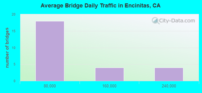
- National Bridge Inventory (NBI) Statistics
- 26Number of bridges
- 548ft / 167mTotal length
- 1,575,868Total average daily traffic
- 82,151Total average daily truck traffic
- National Bridge Inventory (NBI) Registered Bridges for Encinitas
- No street view available for this location
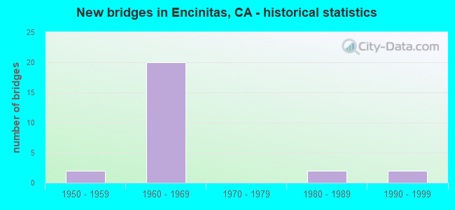
- New bridges - historical statistics
- 21950-1959
- 201960-1969
- 21980-1989
- 21990-1999
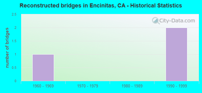
- Reconstructed bridges - Historical Statistics
- 11960-1969
- 01970-1979
- 01980-1989
- 21990-1999
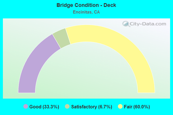
- Bridge Condition - Deck
- 33.3%Good
- 6.7%Satisfactory
- 60.0%Fair
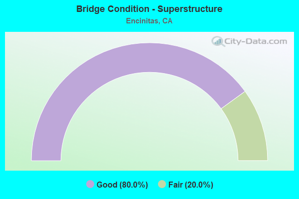
- Bridge Condition - Superstructure
- 80.0%Good
- 20.0%Fair
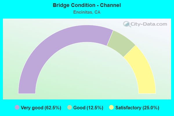
- Bridge Condition - Channel
- 62.5%Very good
- 12.5%Good
- 25.0%Satisfactory
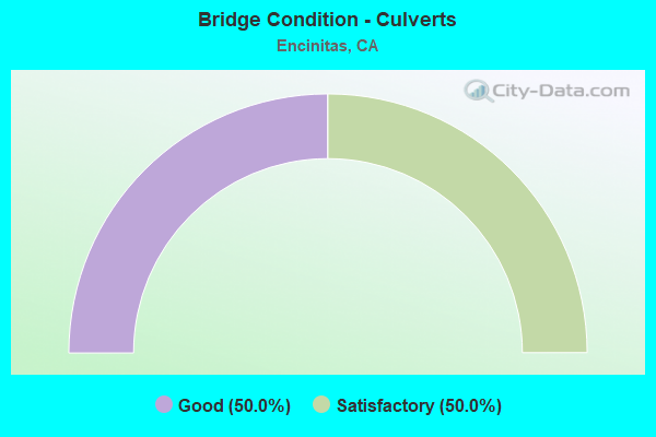
- Bridge Condition - Culverts
- 50.0%Good
- 50.0%Satisfactory
Find on map >> Show street view
Structure Number: 57 0520L, Location: 11-SD-052-0.19-SD (Lat: 32.838486, Lng: -117.234706), Route carried "on" structure: State highway 52, Year Built: 1966, Status: Open, Structure Length: 53.74m (176.31ft), Average Daily Traffic: 18,200 (year 2019), Truck Traffic: 3%, Average Future Daily Traffic: 21,519 (year 2043), Design Load: HS 20+Mod, Features Intersected: MTDB,BNSF,AMTRAK,I 5,CON
Minimum Vertical Clearance: 30+ m (98+ ft), Kilometerpoint: 0.190, Lanes on structure: 3, Lanes under structure: 14, Base Highway Network: Yes (, Subroute: 1), Owner: State Highway Agency, Approaching Roadway Width: 12.2m (40.0ft), Skew: 9 degrees, Material/Design: Concrete continuous, Design/Construction: Box Beam or Girders - Single/Spread, Number Of Spans In Main Unit: 17, Length of Maximum Span: 39.6m (129.9ft), Curb or Sidewalk Widths: Left: 0.6m (2.0ft), Right: 0.6m (2.0ft), Curb-To-Curb Width: 12.2m (40.0ft), Out-to-Out Width: 14.0m (45.9ft)
Condition: Deck: Satisfactory, Superstructure: Good, Substructure: Good, Operating Rating: 69.3 metric tons, Method Used To Determine Operating Rating: Load Factor (LF), Inventory Rating: 41.8 metric tons, Method Used To Determine Inventory Rating: Load Factor (LF), Structural Evaluation: Better than present minimum criteria, Deck Geometry: High priority of corrective action, Underclear: Somewhat better than minimum adequacy, Approach Roadway Alignment: Equal to present desirable criteria, Designated Inspection Frequency: Every 24 months, Inspection Date: Febuary 2021, Deck Structure Type: Concrete Cast-file-Place
Find on map >> Show street view
Structure Number: 57 0529, Location: 11-SD-005-R39.83-ENTS (Lat: 33.026231, Lng: -117.275206), Route carried "on" structure: County highway S341, Year Built: 1964, Status: Open, Structure Length: 7.19m (23.59ft), Average Daily Traffic: 6,023 (year 2020), Truck Traffic: 2%, Average Future Daily Traffic: 13,395 (year 2040), Design Load: HS 20, Features Intersected: ROUTE 5, Facility Carried by Structure: BIRMINGHAM DR
Minimum Vertical Clearance: 30+ m (98+ ft), Kilometerpoint: 0.000, Lanes on structure: 2, Lanes under structure: 8, Owner: State Highway Agency, Approaching Roadway Width: 8.5m (27.9ft), Material/Design: Concrete continuous, Design/Construction: Box Beam or Girders - Multiple, Number Of Spans In Main Unit: 4, Length of Maximum Span: 24.4m (80.1ft), Curb or Sidewalk Widths: Left: 1.5m (4.9ft), Right: 0.6m (2.0ft), Curb-To-Curb Width: 8.5m (27.9ft), Out-to-Out Width: 11.3m (37.1ft)
Condition: Deck: Fair, Superstructure: Good, Substructure: Good, Operating Rating: 54.1 metric tons, Method Used To Determine Operating Rating: Load and Resistance Factor Rating (LRFR) rating reported by rating factor(RF) method using HL-93 loadings, Inventory Rating: 38.6 metric tons, Method Used To Determine Inventory Rating: Load and Resistance Factor Rating (LRFR) rating reported by rating factor(RF) method using HL-93 loadings, Structural Evaluation: Better than present minimum criteria, Deck Geometry: Meets minimum limits, Underclear: Somewhat better than minimum adequacy, Approach Roadway Alignment: Equal to present minimum criteria, Designated Inspection Frequency: Every 24 months, Inspection Date: March 2021, Deck Structure Type: Concrete Cast-file-Place
Find on map >> Show street view
Structure Number: 57 0531L, Location: 11-SD-005-R40.60-ENTS (Lat: 33.036050, Lng: -117.281336), Route carried "on" structure: Interstate 5, Year Built: 1964, Status: Open, Structure Length: 4.48m (14.70ft), Average Daily Traffic: 105,000 (year 2020), Truck Traffic: 6%, Average Future Daily Traffic: 138,589 (year 2040), Design Load: HS 20, Features Intersected: SANTA FE DR
Minimum Vertical Clearance: 30+ m (98+ ft), Kilometerpoint: 40.600, Lanes on structure: 4, Lanes under structure: 4, Base Highway Network: Yes (, Subroute: 1), Owner: State Highway Agency, Approaching Roadway Width: 14.6m (47.9ft), Skew: 2 degrees, Material/Design: Concrete continuous, Design/Construction: Box Beam or Girders - Multiple, Number Of Spans In Main Unit: 3, Length of Maximum Span: 23.5m (77.1ft), Curb-To-Curb Width: 20.1m (65.9ft), Out-to-Out Width: 20.9m (68.6ft)
Condition: Deck: Good, Superstructure: Good, Substructure: Good, Operating Rating: 41.1 metric tons, Method Used To Determine Operating Rating: Load and Resistance Factor Rating (LRFR) rating reported by rating factor(RF) method using HL-93 loadings, Inventory Rating: 31.1 metric tons, Method Used To Determine Inventory Rating: Load and Resistance Factor Rating (LRFR) rating reported by rating factor(RF) method using HL-93 loadings, Structural Evaluation: Better than present minimum criteria, Deck Geometry: Equal to present minimum criteria, Underclear: High priority of corrective action, Approach Roadway Alignment: Superior to present desirable criteria, Designated Inspection Frequency: Every 24 months, Inspection Date: March 2021, Deck Structure Type: Concrete Cast-file-Place
Find on map >> Show street view
Structure Number: 57 0531R, Location: 11-SD-005-R40.60-ENTS (Lat: 33.036050, Lng: -117.281011), Route carried "on" structure: Interstate 5, Year Built: 1964, Status: Open, Structure Length: 4.48m (14.70ft), Average Daily Traffic: 105,000 (year 2020), Truck Traffic: 6%, Average Future Daily Traffic: 138,589 (year 2040), Design Load: HS 20, Features Intersected: SANTA FE DR
Minimum Vertical Clearance: 30+ m (98+ ft), Kilometerpoint: 40.600, Lanes on structure: 4, Lanes under structure: 5, Base Highway Network: Yes (, Subroute: 1), Owner: State Highway Agency, Approaching Roadway Width: 14.6m (47.9ft), Skew: 2 degrees, Material/Design: Concrete continuous, Design/Construction: Box Beam or Girders - Multiple, Number Of Spans In Main Unit: 3, Length of Maximum Span: 23.5m (77.1ft), Curb-To-Curb Width: 20.1m (65.9ft), Out-to-Out Width: 20.9m (68.6ft)
Condition: Deck: Good, Superstructure: Good, Substructure: Good, Operating Rating: 41.5 metric tons, Method Used To Determine Operating Rating: Load and Resistance Factor Rating (LRFR) rating reported by rating factor(RF) method using HL-93 loadings, Inventory Rating: 31.1 metric tons, Method Used To Determine Inventory Rating: Load and Resistance Factor Rating (LRFR) rating reported by rating factor(RF) method using HL-93 loadings, Structural Evaluation: Better than present minimum criteria, Deck Geometry: Equal to present minimum criteria, Underclear: High priority of corrective action, Approach Roadway Alignment: Superior to present desirable criteria, Designated Inspection Frequency: Every 24 months, Inspection Date: March 2021, Deck Structure Type: Concrete Cast-file-Place
Find on map >> Show street view
Structure Number: 57 0532, Location: 11-SD-005-R41.18-ENTS (Lat: 33.043478, Lng: -117.286158), Route carried "on" structure: County highway , Year Built: 1964, Status: Open, Structure Length: 7.56m (24.80ft), Average Daily Traffic: 10,500 (year 2020), Truck Traffic: 2%, Average Future Daily Traffic: 17,851 (year 2040), Design Load: HS 20, Features Intersected: ROUTE 5, Facility Carried by Structure: REQUEZA STREET
Minimum Vertical Clearance: 30+ m (98+ ft), Kilometerpoint: 0.000, Lanes on structure: 2, Lanes under structure: 8, Owner: State Highway Agency, Approaching Roadway Width: 8.5m (27.9ft), Material/Design: Concrete continuous, Design/Construction: Box Beam or Girders - Multiple, Number Of Spans In Main Unit: 4, Length of Maximum Span: 24.7m (81.0ft), Curb or Sidewalk Widths: Left: 0.6m (2.0ft), Right: 1.5m (4.9ft), Curb-To-Curb Width: 8.5m (27.9ft), Out-to-Out Width: 11.3m (37.1ft)
Condition: Deck: Good, Superstructure: Good, Substructure: Good, Operating Rating: 39.5 metric tons, Method Used To Determine Operating Rating: Load and Resistance Factor Rating (LRFR) rating reported by rating factor(RF) method using HL-93 loadings, Inventory Rating: 27.9 metric tons, Method Used To Determine Inventory Rating: Load and Resistance Factor Rating (LRFR) rating reported by rating factor(RF) method using HL-93 loadings, Structural Evaluation: Better than present minimum criteria, Deck Geometry: Meets minimum limits, Underclear: Somewhat better than minimum adequacy, Approach Roadway Alignment: Equal to present desirable criteria, Designated Inspection Frequency: Every 24 months, Inspection Date: March 2021, Deck Structure Type: Concrete Cast-file-Place
Find on map >> Show street view
Structure Number: 57 0533L, Location: 11-SD-005-R41.51 (Lat: 33.048217, Lng: -117.287200), Route carried "on" structure: Interstate 5, Year Built: 1964, Status: Open, Structure Length: 4.11m (13.48ft), Average Daily Traffic: 105,000 (year 2020), Truck Traffic: 6%, Average Future Daily Traffic: 138,589 (year 2040), Design Load: HS 20, Features Intersected: ENCINITAS BLVD
Minimum Vertical Clearance: 30+ m (98+ ft), Kilometerpoint: 41.510, Lanes on structure: 4, Lanes under structure: 5, Base Highway Network: Yes (, Subroute: 1), Owner: State Highway Agency, Approaching Roadway Width: 14.8m (48.6ft), Skew: 1 degrees, Material/Design: Concrete continuous, Design/Construction: Box Beam or Girders - Multiple, Number Of Spans In Main Unit: 3, Length of Maximum Span: 21.3m (69.9ft), Curb-To-Curb Width: 20.1m (65.9ft), Out-to-Out Width: 20.9m (68.6ft)
Condition: Deck: Fair, Superstructure: Good, Substructure: Good, Operating Rating: 39.2 metric tons, Method Used To Determine Operating Rating: Load and Resistance Factor Rating (LRFR) rating reported by rating factor(RF) method using HL-93 loadings, Inventory Rating: 30.1 metric tons, Method Used To Determine Inventory Rating: Load and Resistance Factor Rating (LRFR) rating reported by rating factor(RF) method using HL-93 loadings, Structural Evaluation: Better than present minimum criteria, Deck Geometry: Equal to present minimum criteria, Underclear: High priority of corrective action, Approach Roadway Alignment: Equal to present desirable criteria, Designated Inspection Frequency: Every 24 months, Inspection Date: March 2021, Deck Structure Type: Concrete Cast-file-Place
Find on map >> Show street view
Structure Number: 57 0533R, Location: 11-SD-005-R41.51-ENTS (Lat: 33.048200, Lng: -117.286906), Route carried "on" structure: Interstate 5, Year Built: 1964, Status: Open, Structure Length: 4.11m (13.48ft), Average Daily Traffic: 105,000 (year 2020), Truck Traffic: 6%, Average Future Daily Traffic: 138,589 (year 2040), Design Load: HS 20, Features Intersected: ENCINITAS BLVD
Minimum Vertical Clearance: 30+ m (98+ ft), Kilometerpoint: 41.510, Lanes on structure: 4, Lanes under structure: 5, Base Highway Network: Yes (, Subroute: 1), Owner: State Highway Agency, Approaching Roadway Width: 20.1m (65.9ft), Skew: 1 degrees, Material/Design: Concrete continuous, Design/Construction: Box Beam or Girders - Multiple, Number Of Spans In Main Unit: 3, Length of Maximum Span: 21.3m (69.9ft), Curb-To-Curb Width: 20.1m (65.9ft), Out-to-Out Width: 20.9m (68.6ft)
Condition: Deck: Fair, Superstructure: Good, Substructure: Good, Operating Rating: 39.2 metric tons, Method Used To Determine Operating Rating: Load and Resistance Factor Rating (LRFR) rating reported by rating factor(RF) method using HL-93 loadings, Inventory Rating: 30.1 metric tons, Method Used To Determine Inventory Rating: Load and Resistance Factor Rating (LRFR) rating reported by rating factor(RF) method using HL-93 loadings, Structural Evaluation: Better than present minimum criteria, Deck Geometry: Equal to present minimum criteria, Underclear: High priority of corrective action, Approach Roadway Alignment: Equal to present desirable criteria, Designated Inspection Frequency: Every 24 months, Inspection Date: March 2021, Deck Structure Type: Concrete Cast-file-Place
Find on map >> Show street view
Structure Number: 57 0554, Location: 11-SD-005-R42.71 (Lat: 33.064997, Lng: -117.292675), Route carried "on" structure: County highway S346, Year Built: 1965, Year Reconstructed: 1999, Status: Open, Structure Length: 6.71m (22.01ft), Average Daily Traffic: 12,100 (year 2020), Truck Traffic: 2%, Average Future Daily Traffic: 22,613 (year 2040), Design Load: HS 20, Features Intersected: INTERSTATE 5, Facility Carried by Structure: LEUCADIA BLVD
Minimum Vertical Clearance: 30+ m (98+ ft), Kilometerpoint: 0.000, Lanes on structure: 6, Lanes under structure: 8, Owner: State Highway Agency, Approaching Roadway Width: 25.8m (84.6ft), Skew: 1 degrees, Material/Design: Concrete continuous, Design/Construction: Box Beam or Girders - Multiple, Number Of Spans In Main Unit: 2, Length of Maximum Span: 33.3m (109.3ft), Curb or Sidewalk Widths: Left: 0.0m, Right: 1.5m (4.9ft), Curb-To-Curb Width: 25.8m (84.6ft), Out-to-Out Width: 29.4m (96.5ft)
Condition: Deck: Good, Superstructure: Good, Substructure: Good, Operating Rating: 86.2 metric tons, Method Used To Determine Operating Rating: Load Factor (LF), Inventory Rating: 51.8 metric tons, Method Used To Determine Inventory Rating: Load Factor (LF), Structural Evaluation: Better than present minimum criteria, Deck Geometry: Somewhat better than minimum adequacy, Underclear: Meets minimum limits, Approach Roadway Alignment: Equal to present desirable criteria, Designated Inspection Frequency: Every 24 months, Inspection Date: March 2021, Deck Structure Type: Concrete Cast-file-Place
Find on map >> Show street view
Structure Number: 57C0183, Location: 0.3MI N/O SEA WORLD DR (Lat: 32.770628, Lng: -117.207717), Route carried "on" structure: City street , Year Built: 1967, Status: Open, Structure Length: 2.44m (8.01ft), Average Daily Traffic: 5,389 (year 2016), Truck Traffic: 2%, Average Future Daily Traffic: 5,700 (year 2038), Design Load: HS 20, Features Intersected: TECOLOTE CREEK, Facility Carried by Structure: E MISSION BAY DR
Minimum Vertical Clearance: 30+ m (98+ ft), Kilometerpoint: 0.000, Lanes on structure: 2, Owner: City or Municipal Highway Agency, Approaching Roadway Width: 8.2m (26.9ft), Skew: 1 degrees, Material/Design: Concrete, Design/Construction: Box Beam or Girders - Multiple, Number Of Spans In Main Unit: 1, Length of Maximum Span: 23.8m (78.1ft), Curb or Sidewalk Widths: Left: 0.6m (2.0ft), Right: 0.6m (2.0ft), Curb-To-Curb Width: 8.5m (27.9ft), Out-to-Out Width: 10.4m (34.1ft)
Condition: Deck: Fair, Superstructure: Good, Substructure: Good, Channel: Very good, Operating Rating: 48.0 metric tons, Method Used To Determine Operating Rating: Load and Resistance Factor Rating (LRFR) rating reported by rating factor(RF) method using HL-93 loadings, Inventory Rating: 36.9 metric tons, Method Used To Determine Inventory Rating: Load and Resistance Factor Rating (LRFR) rating reported by rating factor(RF) method using HL-93 loadings, Structural Evaluation: Better than present minimum criteria, Deck Geometry: High priority of replacement, Waterway Adequacy: Equal to present desirable criteria, Approach Roadway Alignment: Better than present minimum criteria, Designated Inspection Frequency: Every 24 months, Inspection Date: September 2020, Deck Structure Type: Concrete Cast-file-Place
Find on map >> Show street view
Structure Number: 57C0189, Location: AT OLIVENHAIN / LEUCADIA (Lat: 33.067289, Lng: -117.262044), Route carried "on" structure: County highway , Year Built: 1962, Year Reconstructed: 1997, Status: Open, Structure Length: 1.52m (4.99ft), Average Daily Traffic: 29,047 (year 2016), Truck Traffic: 2%, Average Future Daily Traffic: 32,415 (year 2040), Design Load: HS 20, Features Intersected: ENCINITAS CREEK, Facility Carried by Structure: EL CAMINO REAL
Minimum Vertical Clearance: 30+ m (98+ ft), Kilometerpoint: 0.000, Lanes on structure: 10, Base Highway Network: Yes, Owner: City or Municipal Highway Agency, Approaching Roadway Width: 40.0m (131.2ft), Skew: 1 degrees, Material/Design: Concrete continuous, Design/Construction: Slab, Number Of Spans In Main Unit: 2, Length of Maximum Span: 7.3m (24.0ft), Curb-To-Curb Width: 40.0m (131.2ft), Out-to-Out Width: 53.0m (173.9ft)
Condition: Deck: Good, Superstructure: Good, Substructure: Good, Channel: Very good, Operating Rating: 45.0 metric tons, Method Used To Determine Operating Rating: Load Factor (LF), Inventory Rating: 27.2 metric tons, Method Used To Determine Inventory Rating: Load Factor (LF), Structural Evaluation: Equal to present minimum criteria, Deck Geometry: Somewhat better than minimum adequacy, Waterway Adequacy: Better than present minimum criteria, Approach Roadway Alignment: Equal to present desirable criteria, Designated Inspection Frequency: Every 24 months, Inspection Date: April 2020, Deck Structure Type: Concrete Cast-file-Place, Wearing Surface/Protective System: Wearing Surface: Bituminous
Find on map >> Show street view
Structure Number: 57C027, Location: 3.5 MI S/O ROUTE I-8 (Lat: 32.715381, Lng: -116.499436), Route carried "on" structure: County highway , Year Built: 1950, Status: Open, Structure Length: 13.56m (44.49ft), Average Daily Traffic: 4,300 (year 2016), Truck Traffic: 2%, Average Future Daily Traffic: 4,531 (year 2038), Design Load: H 15, Features Intersected: COTTONWOOD CREEK, Facility Carried by Structure: BUCKMAN SPRINGS RD
Minimum Vertical Clearance: 30+ m (98+ ft), Kilometerpoint: 0.000, Lanes on structure: 2, Owner: County Highway Agency, Approaching Roadway Width: 7.9m (25.9ft), Material/Design: Concrete continuous, Design/Construction: Tee Beam, Number Of Spans In Main Unit: 10, Length of Maximum Span: 16.5m (54.1ft), Curb or Sidewalk Widths: Left: 0.5m (1.6ft), Right: 0.5m (1.6ft), Curb-To-Curb Width: 7.3m (24.0ft), Out-to-Out Width: 8.2m (26.9ft)
Condition: Deck: Fair, Superstructure: Good, Substructure: Good, Channel: Very good, Operating Rating: 30.5 metric tons, Method Used To Determine Operating Rating: Load and Resistance Factor Rating (LRFR) rating reported by rating factor(RF) method using HL-93 loadings, Inventory Rating: 23.3 metric tons, Method Used To Determine Inventory Rating: Load and Resistance Factor Rating (LRFR) rating reported by rating factor(RF) method using HL-93 loadings, Structural Evaluation: Equal to present minimum criteria, Deck Geometry: High priority of replacement, Waterway Adequacy: Equal to present desirable criteria, Approach Roadway Alignment: Better than present minimum criteria, Designated Inspection Frequency: Every 24 months, Inspection Date: January 2021, Deck Structure Type: Concrete Cast-file-Place
Find on map >> Show street view
Structure Number: 57C0310L, Location: 0.3MI N/O MISSION BAY DR (Lat: 32.768950, Lng: -117.233914), Route carried "on" structure: City street , Year Built: 1987, Status: Open, Structure Length: 36.18m (118.70ft), Average Daily Traffic: 17,700 (year 2012), Truck Traffic: 2%, Average Future Daily Traffic: 26,810 (year 2038), Design Load: HS 20+Mod, Features Intersected: MISSION BAY CHANNEL, Facility Carried by Structure: INGRAHAM ST S/B
Minimum Vertical Clearance: 30+ m (98+ ft), Kilometerpoint: 0.000, Lanes on structure: 2, Base Highway Network: Yes, Owner: City or Municipal Highway Agency, Approaching Roadway Width: 10.7m (35.1ft), Material/Design: Prestressed concrete continuous, Design/Construction: Stringer/Multi-beam, Number Of Spans In Main Unit: 9, Length of Maximum Span: 40.2m (131.9ft), Curb or Sidewalk Widths: Left: 1.9m (6.2ft), Right: 0.0m, Curb-To-Curb Width: 10.4m (34.1ft), Out-to-Out Width: 13.4m (44.0ft)
Condition: Deck: Fair, Superstructure: Good, Substructure: Good, Channel: Very good, Operating Rating: 54.1 metric tons, Method Used To Determine Operating Rating: Assigned rating based on Load Factor Design (LFD) reported in metric tons, Inventory Rating: 32.4 metric tons, Method Used To Determine Inventory Rating: Assigned rating based on Load Factor Design (LFD) reported in metric tons, Structural Evaluation: Better than present minimum criteria, Deck Geometry: Somewhat better than minimum adequacy, Waterway Adequacy: Superior to present desirable criteria, Approach Roadway Alignment: Equal to present desirable criteria, Designated Inspection Frequency: Every 24 months, Underwater Inspection Frequency: Every 60 months, Inspection Date: October 2021, Underwater Inspection Date: August 2018, Deck Structure Type: Concrete Cast-file-Place
Find on map >> Show street view
Structure Number: 57C0315, Location: 15FT N/O LA ORILLA RD (Lat: 33.010925, Lng: -117.239414), Route carried "on" structure: City street , Year Built: 1950, Year Reconstructed: 1966, Status: Open, Structure Length: 0.67m (2.20ft), Average Daily Traffic: 3,948 (year 2016), Truck Traffic: 1%, Average Future Daily Traffic: 6,293 (year 2038), Features Intersected: SAN ELIJO LAGOON TRIB, Facility Carried by Structure: EL CAMINO REAL
Minimum Vertical Clearance: 30+ m (98+ ft), Kilometerpoint: 0.000, Lanes on structure: 2, Owner: County Highway Agency, Approaching Roadway Width: 8.5m (27.9ft), Material/Design: Concrete, Design/Construction: Culvert, Number Of Spans In Main Unit: 2, Length of Maximum Span: 3.0m (9.8ft), Curb-To-Curb Width: 12.2m (40.0ft), Out-to-Out Width: 12.6m (41.3ft)
Condition: Channel: Satisfactory, Culverts: Good, Operating Rating: 40.5 metric tons, Method Used To Determine Operating Rating: Field evaluation and documented engineering judgment, Inventory Rating: 24.3 metric tons, Method Used To Determine Inventory Rating: Field evaluation and documented engineering judgment, Structural Evaluation: Equal to present minimum criteria, Deck Geometry: Equal to present minimum criteria, Waterway Adequacy: High priority of corrective action, Approach Roadway Alignment: Meets minimum limits, Designated Inspection Frequency: Every 24 months, Inspection Date: May 2021
Find on map >> Show street view
Structure Number: 57C0316, Location: 150FT E/O COAST HWY 101 (Lat: 33.082794, Lng: -117.308264), Route carried "on" structure: City street , Year Built: 1968, Status: Open, Structure Length: 3.51m (11.52ft), Average Daily Traffic: 11,781 (year 2016), Truck Traffic: 1%, Average Future Daily Traffic: 14,087 (year 2040), Features Intersected: NCTD, BNSF RY, & AMTRAK, Facility Carried by Structure: LA COSTA AVE
Minimum Vertical Clearance: 30+ m (98+ ft), Kilometerpoint: 0.000, Lanes on structure: 2, Owner: City or Municipal Highway Agency, Approaching Roadway Width: 12.2m (40.0ft), Skew: 2 degrees, Material/Design: Concrete continuous, Design/Construction: Slab, Number Of Spans In Main Unit: 3, Length of Maximum Span: 11.6m (38.1ft), Curb or Sidewalk Widths: Left: 1.2m (3.9ft), Right: 0.0m, Curb-To-Curb Width: 8.5m (27.9ft), Out-to-Out Width: 10.4m (34.1ft)
Condition: Deck: Fair, Superstructure: Fair, Substructure: Good, Operating Rating: 31.8 metric tons, Method Used To Determine Operating Rating: Field evaluation and documented engineering judgment, Inventory Rating: 19.1 metric tons, Method Used To Determine Inventory Rating: Field evaluation and documented engineering judgment, Structural Evaluation: Meets minimum limits, Deck Geometry: High priority of replacement, Underclear: Equal to present minimum criteria, Approach Roadway Alignment: Equal to present desirable criteria, Designated Inspection Frequency: Every 24 months, Inspection Date: April 2020, Deck Structure Type: Concrete Cast-file-Place
Find on map >> Show street view
Structure Number: 57C0569, Location: 1.36M E/O RANCHO SANTA FE (Lat: 33.059225, Lng: -117.215922), Route carried "on" structure: County highway , Year Built: 1980, Status: Open, Structure Length: 0.91m (2.99ft), Average Daily Traffic: 6,446 (year 2016), Truck Traffic: 2%, Average Future Daily Traffic: 7,193 (year 2040), Features Intersected: COPPER CREEK, Facility Carried by Structure: LONE JACK RD
Minimum Vertical Clearance: 30+ m (98+ ft), Kilometerpoint: 0.000, Lanes on structure: 2, Owner: City or Municipal Highway Agency, Approaching Roadway Width: 8.5m (27.9ft), Skew: 2 degrees, Material/Design: Concrete, Design/Construction: Culvert, Number Of Spans In Main Unit: 2, Length of Maximum Span: 3.7m (12.1ft), Curb or Sidewalk Widths: Left: 0.2m (0.7ft), Right: 0.0m, Curb-To-Curb Width: 8.5m (27.9ft), Out-to-Out Width: 16.2m (53.1ft)
Condition: Channel: Satisfactory, Culverts: Satisfactory, Operating Rating: 54.1 metric tons, Method Used To Determine Operating Rating: Field evaluation and documented engineering judgment, Inventory Rating: 32.4 metric tons, Method Used To Determine Inventory Rating: Field evaluation and documented engineering judgment, Structural Evaluation: Equal to present minimum criteria, Deck Geometry: High priority of replacement, Waterway Adequacy: Equal to present desirable criteria, Approach Roadway Alignment: Equal to present minimum criteria, Designated Inspection Frequency: Every 48 months, Inspection Date: April 2020, Deck Structure Type: Concrete Cast-file-Place, Wearing Surface/Protective System: Wearing Surface: Bituminous
Find on map >> Show street view
Structure Number: 57C0647, Location: 0.2MI E/O MANCHESTER AVE (Lat: 33.033986, Lng: -117.235461), Route carried "on" structure: City street , Year Built: 1997, Status: Open, Structure Length: 12.68m (41.60ft), Average Daily Traffic: 17,159 (year 2016), Truck Traffic: 3%, Average Future Daily Traffic: 18,343 (year 2038), Design Load: HS 20+Mod, Features Intersected: ESCONDIDO CREEK, Facility Carried by Structure: RANCHO SANTA FE RD
Minimum Vertical Clearance: 30+ m (98+ ft), Kilometerpoint: 0.000, Lanes on structure: 2, Owner: County Highway Agency, Approaching Roadway Width: 11.0m (36.1ft), Skew: 1 degrees, Material/Design: Prestressed concrete continuous, Design/Construction: Slab, Number Of Spans In Main Unit: 7, Length of Maximum Span: 19.5m (64.0ft), Curb or Sidewalk Widths: Left: 0.0m, Right: 1.7m (5.6ft), Curb-To-Curb Width: 11.0m (36.1ft), Out-to-Out Width: 13.9m (45.6ft)
Condition: Deck: Fair, Superstructure: Fair, Substructure: Good, Channel: Very good, Operating Rating: 54.1 metric tons, Method Used To Determine Operating Rating: Assigned rating based on Load Factor Design (LFD) reported in metric tons, Inventory Rating: 32.4 metric tons, Method Used To Determine Inventory Rating: Assigned rating based on Load Factor Design (LFD) reported in metric tons, Structural Evaluation: Somewhat better than minimum adequacy, Deck Geometry: Meets minimum limits, Waterway Adequacy: Meets minimum limits, Approach Roadway Alignment: Equal to present desirable criteria, Designated Inspection Frequency: Every 24 months, Inspection Date: May 2021, Deck Structure Type: Concrete Cast-file-Place
Find on map >> Show street view
Structure Number: 57C0811, Location: 50FT W/O EL CAMINO REAL (Lat: 33.067397, Lng: -117.262961), Route carried "on" structure: City street , Year Built: 1996, Status: Open, Structure Length: 3.17m (10.40ft), Average Daily Traffic: 26,640 (year 2012), Truck Traffic: 1%, Average Future Daily Traffic: 32,645 (year 2040), Design Load: HS 20+Mod, Features Intersected: ENCINITAS CREEK SOUTH BR, Facility Carried by Structure: LEUCADIA BLVD
Minimum Vertical Clearance: 30+ m (98+ ft), Kilometerpoint: 0.000, Lanes on structure: 9, Owner: City or Municipal Highway Agency, Approaching Roadway Width: 35.5m (116.5ft), Skew: 20 degrees, Material/Design: Concrete continuous, Design/Construction: Slab, Number Of Spans In Main Unit: 3, Length of Maximum Span: 12.2m (40.0ft), Curb or Sidewalk Widths: Left: 1.7m (5.6ft), Right: 2.6m (8.5ft), Curb-To-Curb Width: 35.7m (117.1ft), Out-to-Out Width: 42.0m (137.8ft)
Condition: Deck: Fair, Superstructure: Fair, Substructure: Good, Channel: Good, Operating Rating: 54.1 metric tons, Method Used To Determine Operating Rating: Assigned rating based on Load Factor Design (LFD) reported in metric tons, Inventory Rating: 32.4 metric tons, Method Used To Determine Inventory Rating: Assigned rating based on Load Factor Design (LFD) reported in metric tons, Structural Evaluation: Somewhat better than minimum adequacy, Deck Geometry: Somewhat better than minimum adequacy, Waterway Adequacy: Better than present minimum criteria, Approach Roadway Alignment: Equal to present desirable criteria, Designated Inspection Frequency: Every 24 months, Inspection Date: April 2020, Deck Structure Type: Concrete Cast-file-Place
Find on map >> Show street view
Structure Number: 57 0529, Location: 11-SD-005-R39.83-ENTS (Lat: 33.026231, Lng: -117.275206), Route carried "under" structure: Interstate 5, Year Built: 1964, Structure Length: 0. m, Average Daily Traffic: 210,000 (year 2020), Truck Traffic: 6%, Features Intersected: ROUTE 5, Facility Carried by Structure: BIRMINGHAM DR
Minimum Vertical Clearance: 5.56m (18.24ft), Kilometerpoint: 39.830, Lanes on structure: 2, Lanes under structure: 8, Material/Design: Concrete continuous, Design/Construction: Box Beam or Girders - Multiple, Length of Maximum Span: 24.4m (80.1ft)
Find on map >> Show street view
Structure Number: 57 053, Location: 11-SD-005-R40.12 (Lat: 33.029297, Lng: -117.277250), Route carried "under" structure: Interstate 5, Year Built: 1964, Structure Length: 0. m, Average Daily Traffic: 210,000 (year 2020), Truck Traffic: 6%, Features Intersected: INTERSTATE 5, Facility Carried by Structure: MACKINNON AVE
Minimum Vertical Clearance: 6.65m (21.82ft), Kilometerpoint: 40.120, Lanes on structure: 2, Lanes under structure: 8, Material/Design: Prestressed concrete continuous, Design/Construction: Box Beam or Girders - Multiple, Length of Maximum Span: 50.6m (166.0ft)
Find on map >> Show street view
Structure Number: 57 0531L, Location: 11-SD-005-R40.60-ENTS (Lat: 33.036050, Lng: -117.281336), Route carried "under" structure: County highway S343, Year Built: 1964, Structure Length: 0. m, Average Daily Traffic: 24,700 (year 2020), Truck Traffic: 2%, Features Intersected: SANTA FE DR, Facility Carried by Structure: RTE 5
Minimum Vertical Clearance: 5.66m (18.57ft), Kilometerpoint: 0.000, Lanes on structure: 4, Lanes under structure: 4, Material/Design: Concrete continuous, Design/Construction: Box Beam or Girders - Multiple, Length of Maximum Span: 23.5m (77.1ft)
Find on map >> Show street view
Structure Number: 57 0531R, Location: 11-SD-005-R40.60-ENTS (Lat: 33.036050, Lng: -117.281011), Route carried "under" structure: County highway S343, Year Built: 1964, Structure Length: 0. m, Average Daily Traffic: 24,700 (year 2020), Truck Traffic: 2%, Features Intersected: SANTA FE DR, Facility Carried by Structure: RTE 5
Minimum Vertical Clearance: 5.08m (16.67ft), Kilometerpoint: 0.000, Lanes on structure: 4, Lanes under structure: 5, Material/Design: Concrete continuous, Design/Construction: Box Beam or Girders - Multiple, Length of Maximum Span: 23.5m (77.1ft)
Find on map >> Show street view
Structure Number: 57 0532, Location: 11-SD-005-R41.18-ENTS (Lat: 33.043478, Lng: -117.286158), Route carried "under" structure: Interstate 5, Year Built: 1964, Structure Length: 0. m, Average Daily Traffic: 210,000 (year 2020), Truck Traffic: 6%, Features Intersected: ROUTE 5, Facility Carried by Structure: REQUEZA STREET
Minimum Vertical Clearance: 5.26m (17.26ft), Kilometerpoint: 41.180, Lanes on structure: 2, Lanes under structure: 8, Material/Design: Concrete continuous, Design/Construction: Box Beam or Girders - Multiple, Length of Maximum Span: 24.7m (81.0ft)
Find on map >> Show street view
Structure Number: 57 0533L, Location: 11-SD-005-R41.51 (Lat: 33.048217, Lng: -117.287200), Route carried "under" structure: County highway S159, Year Built: 1964, Structure Length: 0. m, Average Daily Traffic: 34,100 (year 2020), Truck Traffic: 2%, Features Intersected: ENCINITAS BLVD, Facility Carried by Structure: INTERSTATE 5 SB
Minimum Vertical Clearance: 5.64m (18.50ft), Kilometerpoint: 0.000, Lanes on structure: 4, Lanes under structure: 5, Material/Design: Concrete continuous, Design/Construction: Box Beam or Girders - Multiple, Length of Maximum Span: 21.3m (69.9ft)
Find on map >> Show street view
Structure Number: 57 0533R, Location: 11-SD-005-R41.51-ENTS (Lat: 33.048200, Lng: -117.286906), Route carried "under" structure: County highway S159, Year Built: 1964, Structure Length: 0. m, Average Daily Traffic: 34,100 (year 2020), Truck Traffic: 2%, Features Intersected: ENCINITAS BLVD, Facility Carried by Structure: INTERSTATE 5 NB
Minimum Vertical Clearance: 4.72m (15.49ft), Kilometerpoint: 0.000, Lanes on structure: 4, Lanes under structure: 5, Material/Design: Concrete continuous, Design/Construction: Box Beam or Girders - Multiple, Length of Maximum Span: 21.3m (69.9ft)
Find on map >> Show street view
Structure Number: 57 0554, Location: 11-SD-005-R42.71 (Lat: 33.064997, Lng: -117.292675), Route carried "under" structure: Interstate 5, Year Built: 1965, Structure Length: 0. m, Average Daily Traffic: 222,000 (year 2020), Truck Traffic: 6%, Features Intersected: INTERSTATE 5, Facility Carried by Structure: LEUCADIA BLVD
Minimum Vertical Clearance: 5.00m (16.40ft), Kilometerpoint: 42.710, Lanes on structure: 6, Lanes under structure: 8, Material/Design: Concrete continuous, Design/Construction: Box Beam or Girders - Multiple, Length of Maximum Span: 33.3m (109.3ft)
Find on map >> Show street view
Structure Number: 57C0276, Location: 175FT E/O COAST HWY 101 (Lat: 33.048617, Lng: -117.293392), Route carried "under" structure: City street , Year Built: 1966, Structure Length: 0. m, Average Daily Traffic: 17,035 (year 2017), Truck Traffic: 1%, Features Intersected: ENCINITAS BLVD, Facility Carried by Structure: MTDB, BNSF, AMTRAK
Minimum Vertical Clearance: 4.60m (15.09ft), Kilometerpoint: 0.000, Lanes under structure: 4, Material/Design: Steel, Design/Construction: Stringer/Multi-beam, Length of Maximum Span: 25.6m (84.0ft)