Bridge Statistics for Erwin, New York (NY)
Condition, Traffic, Stress, Structural Evaluation, Project Costs
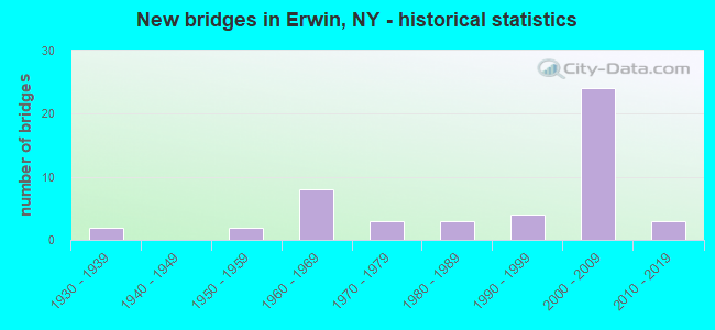
- New bridges - historical statistics
- 21930-1939
- 21950-1959
- 81960-1969
- 31970-1979
- 31980-1989
- 41990-1999
- 242000-2009
- 32010-2019
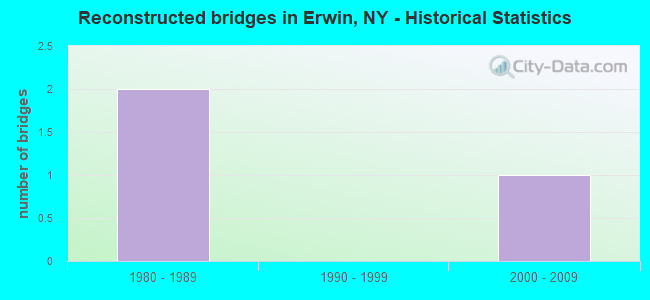
- Reconstructed bridges - Historical Statistics
- 21980-1989
- 01990-1999
- 12000-2009
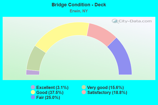
- Bridge Condition - Deck
- 3.1%Excellent
- 15.6%Very good
- 37.5%Good
- 18.8%Satisfactory
- 25.0%Fair
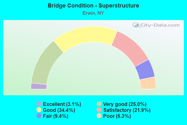
- Bridge Condition - Superstructure
- 3.1%Excellent
- 25.0%Very good
- 34.4%Good
- 21.9%Satisfactory
- 9.4%Fair
- 6.3%Poor
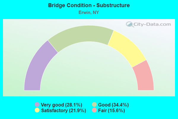
- Bridge Condition - Substructure
- 28.1%Very good
- 34.4%Good
- 21.9%Satisfactory
- 15.6%Fair
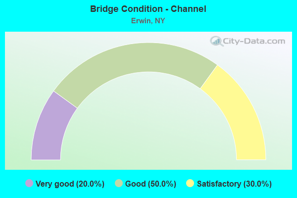
- Bridge Condition - Channel
- 20.0%Very good
- 50.0%Good
- 30.0%Satisfactory
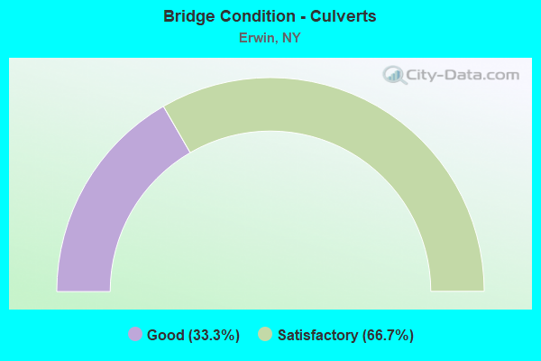
- Bridge Condition - Culverts
- 33.3%Good
- 66.7%Satisfactory
Find on map >> Show street view
Structure Number: 1011141, Location: JCT RTE 15 + CANISTEO R (Lat: 42.105819, Lng: -77.155089), Route carried "on" structure: Interstate 15U, Year Built: 1969, Status: Open, Structure Length: 6.86m (22.51ft), Average Daily Traffic: 5,549 (year 2019), Truck Traffic: 33%, Average Future Daily Traffic: 10,351 (year 2040), Design Load: HS 20, Features Intersected: CANISTEO RIVER
Minimum Vertical Clearance: 30+ m (98+ ft), Kilometerpoint: 12.582, Lanes on structure: 2, Base Highway Network: Yes, Owner: State Highway Agency, Approaching Roadway Width: 12.2m (40.0ft), Material/Design: Steel, Design/Construction: Stringer/Multi-beam, Number Of Spans In Main Unit: 2, Length of Maximum Span: 33.5m (109.9ft), Curb-To-Curb Width: 11.9m (39.0ft), Out-to-Out Width: 12.8m (42.0ft)
Condition: Deck: Fair, Superstructure: Satisfactory, Substructure: Satisfactory, Channel: Good, Operating Rating: 84.4 metric tons, Method Used To Determine Operating Rating: Load Factor (LF), Inventory Rating: 49.9 metric tons, Method Used To Determine Inventory Rating: Load Factor (LF), Structural Evaluation: Equal to present minimum criteria, Deck Geometry: Equal to present minimum criteria, Waterway Adequacy: Meets minimum limits, Approach Roadway Alignment: Equal to present desirable criteria, Length Of Structure Improvement: 6.85m (22.47ft), Designated Inspection Frequency: Every 24 months, Inspection Date: May 2020, Bridge Improvement Cost: $2,459,000, Roadway Improvement Cost: $1,440,000, Total Project Cost: $3,898,000 ( Estimate for 2021), Deck Structure Type: Concrete Cast-file-Place, Wearing Surface/Protective System: Wearing Surface: Epoxy Overlay
Find on map >> Show street view
Structure Number: 1011142, Location: JCT RTE 15 + CANISTEO R (Lat: 42.105764, Lng: -77.154711), Route carried "on" structure: Interstate 15U, Year Built: 1969, Status: Open, Structure Length: 6.86m (22.51ft), Average Daily Traffic: 5,549 (year 2019), Truck Traffic: 33%, Average Future Daily Traffic: 10,351 (year 2040), Design Load: HS 20, Features Intersected: CANISTEO RIVER
Minimum Vertical Clearance: 30+ m (98+ ft), Kilometerpoint: 12.582, Lanes on structure: 2, Base Highway Network: Yes, Owner: State Highway Agency, Approaching Roadway Width: 12.2m (40.0ft), Material/Design: Steel, Design/Construction: Stringer/Multi-beam, Number Of Spans In Main Unit: 2, Length of Maximum Span: 33.5m (109.9ft), Curb-To-Curb Width: 11.9m (39.0ft), Out-to-Out Width: 12.8m (42.0ft)
Condition: Deck: Fair, Superstructure: Satisfactory, Substructure: Satisfactory, Channel: Good, Operating Rating: 84.4 metric tons, Method Used To Determine Operating Rating: Load Factor (LF), Inventory Rating: 49.9 metric tons, Method Used To Determine Inventory Rating: Load Factor (LF), Structural Evaluation: Equal to present minimum criteria, Deck Geometry: Equal to present minimum criteria, Waterway Adequacy: Meets minimum limits, Approach Roadway Alignment: Equal to present desirable criteria, Length Of Structure Improvement: 6.85m (22.47ft), Designated Inspection Frequency: Every 24 months, Inspection Date: May 2020, Bridge Improvement Cost: $2,459,000, Roadway Improvement Cost: $1,440,000, Total Project Cost: $3,898,000 ( Estimate for 2021), Deck Structure Type: Concrete Cast-file-Place, Wearing Surface/Protective System: Wearing Surface: Epoxy Overlay
Find on map >> Show street view
Structure Number: 1011151, Location: .5 MI SW OF GANG MILLS (Lat: 42.141389, Lng: -77.116486), Route carried "on" structure: Interstate 15U, Year Built: 2004, Status: Open, Structure Length: 5.06m (16.60ft), Average Daily Traffic: 10,601 (year 2018), Truck Traffic: 18%, Average Future Daily Traffic: 16,273 (year 2040), Design Load: HS 25 or greater, Features Intersected: RTE 417
Minimum Vertical Clearance: 30+ m (98+ ft), Kilometerpoint: 17.747, Lanes on structure: 2, Lanes under structure: 4, Base Highway Network: Yes, Owner: State Highway Agency, Approaching Roadway Width: 11.6m (38.1ft), Skew: 4 degrees, Material/Design: Steel, Design/Construction: Stringer/Multi-beam, Number Of Spans In Main Unit: 1, Length of Maximum Span: 49.1m (161.1ft), Curb-To-Curb Width: 11.6m (38.1ft), Out-to-Out Width: 12.6m (41.3ft)
Condition: Deck: Good, Superstructure: Good, Substructure: Good, Operating Rating: 88.0 metric tons, Method Used To Determine Operating Rating: Load Factor (LF), Inventory Rating: 52.6 metric tons, Method Used To Determine Inventory Rating: Load Factor (LF), Structural Evaluation: Better than present minimum criteria, Deck Geometry: Equal to present minimum criteria, Underclear: High priority of corrective action, Approach Roadway Alignment: Equal to present desirable criteria, Length Of Structure Improvement: 4.93m (16.17ft), Designated Inspection Frequency: Every 24 months, Inspection Date: October 2021, Bridge Improvement Cost: $2,356,000, Roadway Improvement Cost: $1,380,000, Total Project Cost: $3,736,000 ( Estimate for 2021), Deck Structure Type: Concrete Cast-file-Place, Wearing Surface/Protective System: Wearing Surface: Integral Concrete, Deck Protection: Epoxy Coated Reinforcing
Find on map >> Show street view
Structure Number: 1011152, Location: .5 MILE SW OF GANG MILLS (Lat: 42.141108, Lng: -77.116608), Route carried "on" structure: Interstate 15U, Year Built: 2005, Status: Open, Structure Length: 5.06m (16.60ft), Average Daily Traffic: 10,601 (year 2018), Truck Traffic: 18%, Average Future Daily Traffic: 16,273 (year 2040), Design Load: HS 25 or greater, Features Intersected: RTE 417
Minimum Vertical Clearance: 30+ m (98+ ft), Kilometerpoint: 17.747, Lanes on structure: 2, Lanes under structure: 4, Base Highway Network: Yes, Owner: State Highway Agency, Approaching Roadway Width: 11.6m (38.1ft), Skew: 4 degrees, Material/Design: Steel, Design/Construction: Stringer/Multi-beam, Number Of Spans In Main Unit: 1, Length of Maximum Span: 49.1m (161.1ft), Curb-To-Curb Width: 11.6m (38.1ft), Out-to-Out Width: 12.6m (41.3ft)
Condition: Deck: Good, Superstructure: Good, Substructure: Good, Operating Rating: 88.0 metric tons, Method Used To Determine Operating Rating: Load Factor (LF), Inventory Rating: 52.6 metric tons, Method Used To Determine Inventory Rating: Load Factor (LF), Structural Evaluation: Better than present minimum criteria, Deck Geometry: Equal to present minimum criteria, Underclear: High priority of corrective action, Approach Roadway Alignment: Equal to present desirable criteria, Length Of Structure Improvement: 4.93m (16.17ft), Designated Inspection Frequency: Every 24 months, Inspection Date: October 2021, Bridge Improvement Cost: $2,356,000, Roadway Improvement Cost: $1,380,000, Total Project Cost: $3,736,000 ( Estimate for 2021), Deck Structure Type: Concrete Cast-file-Place, Wearing Surface/Protective System: Wearing Surface: Integral Concrete, Deck Protection: Epoxy Coated Reinforcing
Find on map >> Show street view
Structure Number: 101116, Location: COHOCTON R./86I RAMPS (Lat: 42.155256, Lng: -77.098497), Route carried "on" structure: County highway 417, Year Built: 2007, Status: Open, Structure Length: 18.75m (61.52ft), Average Daily Traffic: 15,276 (year 2019), Truck Traffic: 3%, Average Future Daily Traffic: 18,557 (year 2040), Design Load: HL 93, Features Intersected: COHOCTON RIVER
Minimum Vertical Clearance: 30+ m (98+ ft), Kilometerpoint: 65.181, Lanes on structure: 4, Owner: Town or Township Highway Agency, Maintenance Responsibility: County Highway Agency, Approaching Roadway Width: 15.8m (51.8ft), Skew: 2 degrees, Material/Design: Steel continuous, Design/Construction: Stringer/Multi-beam, Number Of Spans In Main Unit: 3, Length of Maximum Span: 66.0m (216.5ft), Curb or Sidewalk Widths: Left: 1.7m (5.6ft), Right: 1.7m (5.6ft), Curb-To-Curb Width: 15.9m (52.2ft), Out-to-Out Width: 19.9m (65.3ft)
Condition: Deck: Very good, Superstructure: Very good, Substructure: Very good, Channel: Very good, Operating Rating: 75.0 metric tons, Method Used To Determine Operating Rating: Load Factor (LF), Inventory Rating: 44.0 metric tons, Method Used To Determine Inventory Rating: Load Factor (LF), Structural Evaluation: Equal to present desirable criteria, Deck Geometry: Meets minimum limits, Waterway Adequacy: Equal to present desirable criteria, Approach Roadway Alignment: Equal to present minimum criteria, Length Of Structure Improvement: 18.74m (61.48ft), Designated Inspection Frequency: Every 24 months, Inspection Date: April 2020, Bridge Improvement Cost: $9,057,000, Roadway Improvement Cost: $5,304,000, Total Project Cost: $14,361,000 ( Estimate for 2021), Deck Structure Type: Concrete Cast-file-Place, Wearing Surface/Protective System: Wearing Surface: Integral Concrete, Deck Protection: Epoxy Coated Reinforcing
Find on map >> Show street view
Structure Number: 101119, Location: 0.8 MI NW JCT RTS 15 + 17 (Lat: 42.165594, Lng: -77.103281), Route carried "on" structure: Interstate 86, Year Built: 1959, Status: Open, Structure Length: 1.10m (3.61ft), Average Daily Traffic: 25,927 (year 2019), Truck Traffic: 21%, Average Future Daily Traffic: 39,800 (year 2040), Design Load: HS 20+Mod, Features Intersected: HODGMAN CREEK
Minimum Vertical Clearance: 30+ m (98+ ft), Kilometerpoint: 70.297, Lanes on structure: 6, Base Highway Network: Yes, Owner: State Highway Agency, Approaching Roadway Width: 30.5m (100.1ft), Skew: 23 degrees, Material/Design: Concrete, Design/Construction: Culvert, Number Of Spans In Main Unit: 2, Length of Maximum Span: 4.5m (14.8ft)
Condition: Channel: Satisfactory, Culverts: Satisfactory, Operating Rating: 89.8 metric tons, Method Used To Determine Operating Rating: Load Factor (LF), Inventory Rating: 89.8 metric tons, Method Used To Determine Inventory Rating: Load Factor (LF), Structural Evaluation: Equal to present minimum criteria, Waterway Adequacy: Equal to present minimum criteria, Approach Roadway Alignment: Equal to present desirable criteria, Length Of Structure Improvement: 1.09m (3.58ft), Designated Inspection Frequency: Every 24 months, Inspection Date: October 2021, Bridge Improvement Cost: $1,471,000, Roadway Improvement Cost: $861,000, Total Project Cost: $2,332,000 ( Estimate for 2021)
Find on map >> Show street view
Structure Number: 1011209, Location: 1 MI NW JCT I86 & U.S.15 (Lat: 42.168361, Lng: -77.104153), Route carried "on" structure: Interstate 86, Year Built: 1959, Status: Open, Structure Length: 7.89m (25.89ft), Average Daily Traffic: 25,927 (year 2019), Truck Traffic: 21%, Average Future Daily Traffic: 39,800 (year 2040), Design Load: HS 20+Mod, Features Intersected: B & H RR
Minimum Vertical Clearance: 30+ m (98+ ft), Kilometerpoint: 69.831, Lanes on structure: 6, Base Highway Network: Yes, Owner: State Highway Agency, Approaching Roadway Width: 28.7m (94.2ft), Skew: 24 degrees, Material/Design: Steel continuous, Design/Construction: Stringer/Multi-beam, Number Of Spans In Main Unit: 3, Length of Maximum Span: 33.5m (109.9ft), Curb-To-Curb Width: 28.7m (94.2ft), Out-to-Out Width: 30.3m (99.4ft)
Condition: Deck: Fair, Superstructure: Satisfactory, Substructure: Satisfactory, Operating Rating: 82.6 metric tons, Method Used To Determine Operating Rating: Load Factor (LF), Inventory Rating: 49.0 metric tons, Method Used To Determine Inventory Rating: Load Factor (LF), Structural Evaluation: Equal to present minimum criteria, Deck Geometry: Better than present minimum criteria, Underclear: Equal to present minimum criteria, Approach Roadway Alignment: Equal to present desirable criteria, Length Of Structure Improvement: 7.89m (25.89ft), Designated Inspection Frequency: Every 24 months, Inspection Date: September 2020, Bridge Improvement Cost: $6,148,000, Roadway Improvement Cost: $3,600,000, Total Project Cost: $9,749,000 ( Estimate for 2021), Deck Structure Type: Concrete Cast-file-Place, Wearing Surface/Protective System: Wearing Surface: Epoxy Overlay
Find on map >> Show street view
Structure Number: 1011219, Location: 1.2 MI NW JCT RTS 15+17 (Lat: 42.170478, Lng: -77.104669), Route carried "on" structure: Interstate 86, Year Built: 2010, Status: Open, Structure Length: 2.65m (8.69ft), Average Daily Traffic: 24,911 (year 2019), Truck Traffic: 26%, Average Future Daily Traffic: 38,240 (year 2040), Design Load: HL 93, Features Intersected: RTE 415
Minimum Vertical Clearance: 30+ m (98+ ft), Kilometerpoint: 69.605, Lanes on structure: 4, Lanes under structure: 3, Base Highway Network: Yes, Owner: State Highway Agency, Approaching Roadway Width: 25.3m (83.0ft), Skew: 23 degrees, Material/Design: Prestressed concrete, Design/Construction: Box Beam or Girders - Multiple, Number Of Spans In Main Unit: 1, Length of Maximum Span: 24.9m (81.7ft), Curb-To-Curb Width: 25.4m (83.3ft), Out-to-Out Width: 26.6m (87.3ft)
Condition: Deck: Satisfactory, Superstructure: Good, Substructure: Good, Operating Rating: 97.2 metric tons, Method Used To Determine Operating Rating: Load and Resistance Factor Rating (LRFR) rating reported by rating factor(RF) method using HL-93 loadings, Inventory Rating: 77.4 metric tons, Method Used To Determine Inventory Rating: Load and Resistance Factor Rating (LRFR) rating reported by rating factor(RF) method using HL-93 loadings, Structural Evaluation: Better than present minimum criteria, Deck Geometry: Superior to present desirable criteria, Underclear: Somewhat better than minimum adequacy, Approach Roadway Alignment: Equal to present desirable criteria, Length Of Structure Improvement: 2.65m (8.69ft), Designated Inspection Frequency: Every 24 months, Inspection Date: October 2020, Bridge Improvement Cost: $2,993,000, Roadway Improvement Cost: $1,753,000, Total Project Cost: $4,746,000 ( Estimate for 2021), Deck Structure Type: Concrete Cast-file-Place, Wearing Surface/Protective System: Wearing Surface: Integral Concrete, Deck Protection: Epoxy Coated Reinforcing
Find on map >> Show street view
Structure Number: 104817, Location: 1.8 MI NW OF PAINTED POST (Lat: 42.175689, Lng: -77.121231), Route carried "on" structure: State highway 415, Year Built: 2016, Status: Open, Structure Length: 5.85m (19.19ft), Average Daily Traffic: 3,718 (year 2017), Truck Traffic: 6%, Average Future Daily Traffic: 4,516 (year 2040), Design Load: HL 93, Features Intersected: MEADS CREEK
Minimum Vertical Clearance: 32.69m (107.25ft), Kilometerpoint: 6.516, Lanes on structure: 2, Base Highway Network: Yes, Owner: State Highway Agency, Approaching Roadway Width: 12.8m (42.0ft), Skew: 3 degrees, Material/Design: Steel, Design/Construction: Stringer/Multi-beam, Number Of Spans In Main Unit: 1, Length of Maximum Span: 57.9m (190.0ft), Curb-To-Curb Width: 12.5m (41.0ft), Out-to-Out Width: 13.4m (44.0ft)
Condition: Deck: Very good, Superstructure: Very good, Substructure: Very good, Channel: Very good, Operating Rating: 69.9 metric tons, Method Used To Determine Operating Rating: Load Factor (LF), Inventory Rating: 41.7 metric tons, Method Used To Determine Inventory Rating: Load Factor (LF), Structural Evaluation: Equal to present desirable criteria, Deck Geometry: Equal to present minimum criteria, Waterway Adequacy: Equal to present minimum criteria, Approach Roadway Alignment: Equal to present desirable criteria, Length Of Structure Improvement: 5.85m (19.19ft), Designated Inspection Frequency: Every 24 months, Inspection Date: October 2020, Bridge Improvement Cost: $2,125,000, Roadway Improvement Cost: $1,244,000, Total Project Cost: $3,369,000 ( Estimate for 2021), Deck Structure Type: Concrete Cast-file-Place, Wearing Surface/Protective System: Wearing Surface: Integral Concrete, Deck Protection: Epoxy Coated Reinforcing
Find on map >> Show street view
Structure Number: 104818, Location: 0.4 MI NW OF PAINTED POST (Lat: 42.169031, Lng: -77.100075), Route carried "on" structure: State highway 415, Year Built: 1996, Status: Open, Structure Length: 0.94m (3.08ft), Average Daily Traffic: 4,081 (year 2020), Truck Traffic: 3%, Average Future Daily Traffic: 4,957 (year 2040), Design Load: HS 25 or greater, Features Intersected: ERWIN HOLLOW CRK
Minimum Vertical Clearance: 30+ m (98+ ft), Kilometerpoint: 4.634, Lanes on structure: 2, Base Highway Network: Yes, Owner: State Highway Agency, Approaching Roadway Width: 12.2m (40.0ft), Skew: 20 degrees, Material/Design: Concrete, Design/Construction: Frame, Number Of Spans In Main Unit: 1, Length of Maximum Span: 9.1m (29.9ft), Curb or Sidewalk Widths: Left: 0.0m, Right: 1.5m (4.9ft), Curb-To-Curb Width: 12.2m (40.0ft), Out-to-Out Width: 14.9m (48.9ft)
Condition: Deck: Good, Superstructure: Good, Substructure: Satisfactory, Channel: Satisfactory, Operating Rating: 68.0 metric tons, Method Used To Determine Operating Rating: Load Factor (LF), Inventory Rating: 40.8 metric tons, Method Used To Determine Inventory Rating: Load Factor (LF), Structural Evaluation: Equal to present minimum criteria, Deck Geometry: Equal to present minimum criteria, Waterway Adequacy: Equal to present desirable criteria, Approach Roadway Alignment: Equal to present desirable criteria, Length Of Structure Improvement: 0.94m (3.08ft), Designated Inspection Frequency: Every 24 months, Inspection Date: August 2020, Bridge Improvement Cost: $741,000, Roadway Improvement Cost: $434,000, Total Project Cost: $1,175,000 ( Estimate for 2021), Wearing Surface/Protective System: Wearing Surface: Bituminous
Find on map >> Show street view
Structure Number: 1054561, Location: .3 MI NE JCT SR15 & SR417 (Lat: 42.114792, Lng: -77.151583), Route carried "on" structure: Interstate 15U, Year Built: 1969, Status: Open, Structure Length: 7.83m (25.69ft), Average Daily Traffic: 10,601 (year 2018), Truck Traffic: 18%, Average Future Daily Traffic: 16,273 (year 2040), Design Load: HS 20, Features Intersected: NORFOLK SOUTHERN RR
Minimum Vertical Clearance: 30+ m (98+ ft), Kilometerpoint: 13.628, Lanes on structure: 2, Base Highway Network: Yes, Owner: State Highway Agency, Approaching Roadway Width: 11.6m (38.1ft), Skew: 4 degrees, Material/Design: Steel, Design/Construction: Stringer/Multi-beam, Number Of Spans In Main Unit: 3, Length of Maximum Span: 25.6m (84.0ft), Curb-To-Curb Width: 11.9m (39.0ft), Out-to-Out Width: 12.8m (42.0ft)
Condition: Deck: Satisfactory, Superstructure: Satisfactory, Substructure: Satisfactory, Operating Rating: 63.8 metric tons, Method Used To Determine Operating Rating: Load and Resistance Factor Rating (LRFR) rating reported by rating factor(RF) method using HL-93 loadings, Inventory Rating: 49.2 metric tons, Method Used To Determine Inventory Rating: Load and Resistance Factor Rating (LRFR) rating reported by rating factor(RF) method using HL-93 loadings, Structural Evaluation: Equal to present minimum criteria, Deck Geometry: Equal to present minimum criteria, Underclear: Better than present minimum criteria, Approach Roadway Alignment: Equal to present desirable criteria, Length Of Structure Improvement: 7.83m (25.69ft), Designated Inspection Frequency: Every 24 months, Inspection Date: June 2021, Bridge Improvement Cost: $2,628,000, Roadway Improvement Cost: $1,539,000, Total Project Cost: $4,166,000 ( Estimate for 2021), Deck Structure Type: Concrete Cast-file-Place, Wearing Surface/Protective System: Wearing Surface: Epoxy Overlay
Find on map >> Show street view
Structure Number: 1054562, Location: .3 MI NE JCT SR15 & SR417 (Lat: 42.115033, Lng: -77.150992), Route carried "on" structure: Interstate 15U, Year Built: 1969, Status: Open, Structure Length: 9.33m (30.61ft), Average Daily Traffic: 10,601 (year 2018), Truck Traffic: 18%, Average Future Daily Traffic: 16,273 (year 2040), Design Load: HS 20, Features Intersected: NORFOLK SOUTHERN RR
Minimum Vertical Clearance: 30+ m (98+ ft), Kilometerpoint: 13.628, Lanes on structure: 3, Base Highway Network: Yes, Owner: State Highway Agency, Approaching Roadway Width: 15.8m (51.8ft), Skew: 5 degrees, Material/Design: Steel, Design/Construction: Stringer/Multi-beam, Number Of Spans In Main Unit: 3, Length of Maximum Span: 30.4m (99.7ft), Curb-To-Curb Width: 13.9m (45.6ft), Out-to-Out Width: 14.8m (48.6ft)
Condition: Deck: Fair, Superstructure: Fair, Substructure: Satisfactory, Operating Rating: 52.8 metric tons, Method Used To Determine Operating Rating: Load and Resistance Factor Rating (LRFR) rating reported by rating factor(RF) method using HL-93 loadings, Inventory Rating: 40.5 metric tons, Method Used To Determine Inventory Rating: Load and Resistance Factor Rating (LRFR) rating reported by rating factor(RF) method using HL-93 loadings, Structural Evaluation: Somewhat better than minimum adequacy, Deck Geometry: Meets minimum limits, Underclear: Better than present minimum criteria, Approach Roadway Alignment: Equal to present desirable criteria, Length Of Structure Improvement: 9.32m (30.58ft), Designated Inspection Frequency: Every 24 months, Inspection Date: June 2021, Bridge Improvement Cost: $3,687,000, Roadway Improvement Cost: $2,159,000, Total Project Cost: $5,847,000 ( Estimate for 2021), Deck Structure Type: Concrete Cast-file-Place, Wearing Surface/Protective System: Wearing Surface: Epoxy Overlay
Find on map >> Show street view
Structure Number: 106193, Location: 2.7 MI. EAST OF ADDISON (Lat: 42.115108, Lng: -77.181964), Route carried "on" structure: State highway 417, Year Built: 1987, Status: Open, Structure Length: 5.70m (18.70ft), Average Daily Traffic: 6,359 (year 2020), Truck Traffic: 9%, Average Future Daily Traffic: 6,398 (year 2040), Design Load: HS 20, Features Intersected: NORFOLK SOUTHERN, COLE C
Minimum Vertical Clearance: 30+ m (98+ ft), Kilometerpoint: 55.704, Lanes on structure: 2, Base Highway Network: Yes, Owner: State Highway Agency, Approaching Roadway Width: 12.2m (40.0ft), Skew: 4 degrees, Material/Design: Steel, Design/Construction: Stringer/Multi-beam, Number Of Spans In Main Unit: 1, Length of Maximum Span: 54.8m (179.8ft), Curb-To-Curb Width: 12.0m (39.4ft), Out-to-Out Width: 13.0m (42.7ft)
Condition: Deck: Very good, Superstructure: Very good, Substructure: Fair, Channel: Very good, Operating Rating: 96.2 metric tons, Method Used To Determine Operating Rating: Load Factor (LF), Inventory Rating: 57.2 metric tons, Method Used To Determine Inventory Rating: Load Factor (LF), Structural Evaluation: Somewhat better than minimum adequacy, Deck Geometry: Somewhat better than minimum adequacy, Underclear: Somewhat better than minimum adequacy, Waterway Adequacy: Superior to present desirable criteria, Approach Roadway Alignment: Equal to present desirable criteria, Length Of Structure Improvement: 5.69m (18.67ft), Designated Inspection Frequency: Every 24 months, Inspection Date: June 2020, Bridge Improvement Cost: $2,011,000, Roadway Improvement Cost: $1,177,000, Total Project Cost: $3,188,000 ( Estimate for 2021), Deck Structure Type: Concrete Cast-file-Place, Wearing Surface/Protective System: Wearing Surface: Epoxy Overlay, Deck Protection: Epoxy Coated Reinforcing
Find on map >> Show street view
Structure Number: 1062041, Location: JCT RTS 15 + 417 (Lat: 42.110631, Lng: -77.153242), Route carried "on" structure: Interstate 15U, Year Built: 1969, Status: Open, Structure Length: 3.84m (12.60ft), Average Daily Traffic: 10,601 (year 2019), Truck Traffic: 33%, Average Future Daily Traffic: 16,273 (year 2040), Design Load: HS 20+Mod, Features Intersected: RTE 417
Minimum Vertical Clearance: 30+ m (98+ ft), Kilometerpoint: 13.162, Lanes on structure: 2, Lanes under structure: 3, Base Highway Network: Yes, Owner: State Highway Agency, Approaching Roadway Width: 12.2m (40.0ft), Skew: 2 degrees, Material/Design: Steel, Design/Construction: Stringer/Multi-beam, Number Of Spans In Main Unit: 1, Length of Maximum Span: 37.4m (122.7ft), Curb-To-Curb Width: 11.9m (39.0ft), Out-to-Out Width: 12.8m (42.0ft)
Condition: Deck: Fair, Superstructure: Satisfactory, Substructure: Fair, Operating Rating: 41.5 metric tons, Method Used To Determine Operating Rating: Load and Resistance Factor Rating (LRFR) rating reported by rating factor(RF) method using HL-93 loadings, Inventory Rating: 31.8 metric tons, Method Used To Determine Inventory Rating: Load and Resistance Factor Rating (LRFR) rating reported by rating factor(RF) method using HL-93 loadings, Structural Evaluation: Somewhat better than minimum adequacy, Deck Geometry: Equal to present minimum criteria, Underclear: Meets minimum limits, Approach Roadway Alignment: Equal to present desirable criteria, Length Of Structure Improvement: 3.84m (12.60ft), Designated Inspection Frequency: Every 24 months, Inspection Date: October 2021, Bridge Improvement Cost: $1,625,000, Roadway Improvement Cost: $952,000, Total Project Cost: $2,577,000 ( Estimate for 2021), Deck Structure Type: Concrete Cast-file-Place, Wearing Surface/Protective System: Wearing Surface: Integral Concrete
Find on map >> Show street view
Structure Number: 1062042, Location: JCT RTS 15 + 417 (Lat: 42.110647, Lng: -77.152919), Route carried "on" structure: Interstate 15U, Year Built: 1969, Status: Open, Structure Length: 3.87m (12.70ft), Average Daily Traffic: 10,601 (year 2019), Truck Traffic: 33%, Average Future Daily Traffic: 16,273 (year 2040), Design Load: HS 20+Mod, Features Intersected: RTE 417
Minimum Vertical Clearance: 30+ m (98+ ft), Kilometerpoint: 13.162, Lanes on structure: 2, Lanes under structure: 3, Base Highway Network: Yes, Owner: State Highway Agency, Approaching Roadway Width: 12.2m (40.0ft), Skew: 2 degrees, Material/Design: Steel, Design/Construction: Stringer/Multi-beam, Number Of Spans In Main Unit: 1, Length of Maximum Span: 37.4m (122.7ft), Curb-To-Curb Width: 11.9m (39.0ft), Out-to-Out Width: 12.8m (42.0ft)
Condition: Deck: Fair, Superstructure: Satisfactory, Substructure: Fair, Operating Rating: 41.5 metric tons, Method Used To Determine Operating Rating: Load and Resistance Factor Rating (LRFR) rating reported by rating factor(RF) method using HL-93 loadings, Inventory Rating: 31.8 metric tons, Method Used To Determine Inventory Rating: Load and Resistance Factor Rating (LRFR) rating reported by rating factor(RF) method using HL-93 loadings, Structural Evaluation: Somewhat better than minimum adequacy, Deck Geometry: Equal to present minimum criteria, Underclear: Meets minimum limits, Approach Roadway Alignment: Equal to present desirable criteria, Length Of Structure Improvement: 3.87m (12.70ft), Designated Inspection Frequency: Every 24 months, Inspection Date: October 2021, Bridge Improvement Cost: $1,634,000, Roadway Improvement Cost: $957,000, Total Project Cost: $2,591,000 ( Estimate for 2021), Deck Structure Type: Concrete Cast-file-Place, Wearing Surface/Protective System: Wearing Surface: Integral Concrete
Find on map >> Show street view
Structure Number: 1064251, Location: 0.3 MI NE GANGMILLS (Lat: 42.150872, Lng: -77.102700), Route carried "on" structure: Interstate 15U, Year Built: 2006, Status: Open, Structure Length: 5.30m (17.39ft), Average Daily Traffic: 8,002 (year 2020), Truck Traffic: 20%, Average Future Daily Traffic: 12,284 (year 2040), Design Load: HS 20+Mod, Features Intersected: R Dann EB Ramp
Minimum Vertical Clearance: 30+ m (98+ ft), Kilometerpoint: 19.405, Lanes on structure: 3, Lanes under structure: 2, Base Highway Network: Yes, Owner: State Highway Agency, Approaching Roadway Width: 14.9m (48.9ft), Skew: 3 degrees, Material/Design: Steel, Design/Construction: Stringer/Multi-beam, Number Of Spans In Main Unit: 1, Length of Maximum Span: 50.0m (164.0ft), Curb-To-Curb Width: 15.0m (49.2ft), Out-to-Out Width: 16.0m (52.5ft)
Condition: Deck: Good, Superstructure: Good, Substructure: Good, Operating Rating: 56.7 metric tons, Method Used To Determine Operating Rating: Load and Resistance Factor Rating (LRFR) rating reported by rating factor(RF) method using HL-93 loadings, Inventory Rating: 43.7 metric tons, Method Used To Determine Inventory Rating: Load and Resistance Factor Rating (LRFR) rating reported by rating factor(RF) method using HL-93 loadings, Structural Evaluation: Better than present minimum criteria, Deck Geometry: Meets minimum limits, Underclear: Meets minimum limits, Approach Roadway Alignment: Equal to present desirable criteria, Length Of Structure Improvement: 2.86m (9.38ft), Designated Inspection Frequency: Every 24 months, Inspection Date: August 2021, Bridge Improvement Cost: $2,054,000, Roadway Improvement Cost: $1,203,000, Total Project Cost: $3,256,000 ( Estimate for 2021), Deck Structure Type: Concrete Cast-file-Place, Wearing Surface/Protective System: Wearing Surface: Integral Concrete, Deck Protection: Epoxy Coated Reinforcing
Find on map >> Show street view
Structure Number: 1064252, Location: .3 MILE NE OF GANG MILLS (Lat: 42.150814, Lng: -77.102442), Route carried "on" structure: Interstate 15U, Year Built: 2005, Status: Open, Structure Length: 6.92m (22.70ft), Average Daily Traffic: 8,002 (year 2020), Truck Traffic: 20%, Average Future Daily Traffic: 12,284 (year 2040), Design Load: HS 20+Mod, Features Intersected: R Dann EB Ramp
Minimum Vertical Clearance: 30+ m (98+ ft), Kilometerpoint: 19.405, Lanes on structure: 3, Lanes under structure: 2, Base Highway Network: Yes, Owner: State Highway Agency, Approaching Roadway Width: 19.2m (63.0ft), Material/Design: Steel, Design/Construction: Stringer/Multi-beam, Number Of Spans In Main Unit: 1, Length of Maximum Span: 63.4m (208.0ft), Curb-To-Curb Width: 17.1m (56.1ft), Out-to-Out Width: 20.1m (65.9ft)
Condition: Deck: Good, Superstructure: Good, Substructure: Good, Operating Rating: 84.4 metric tons, Method Used To Determine Operating Rating: Load Factor (LF), Inventory Rating: 49.9 metric tons, Method Used To Determine Inventory Rating: Load Factor (LF), Structural Evaluation: Better than present minimum criteria, Deck Geometry: Equal to present minimum criteria, Underclear: Meets minimum limits, Approach Roadway Alignment: Equal to present desirable criteria, Length Of Structure Improvement: 2.86m (9.38ft), Designated Inspection Frequency: Every 24 months, Inspection Date: August 2021, Bridge Improvement Cost: $2,550,000, Roadway Improvement Cost: $1,493,000, Total Project Cost: $4,044,000 ( Estimate for 2021), Deck Structure Type: Concrete Cast-file-Place, Wearing Surface/Protective System: Wearing Surface: Integral Concrete, Deck Protection: Epoxy Coated Reinforcing
Find on map >> Show street view
Structure Number: 107232, Location: 3 MILES S OF GANG MILLS (Lat: 42.125286, Lng: -77.135611), Route carried "on" structure: Interstate 15U, Year Built: 1976, Status: Open, Structure Length: 1.19m (3.90ft), Average Daily Traffic: 21,201 (year 2018), Truck Traffic: 18%, Average Future Daily Traffic: 32,545 (year 2040), Design Load: HS 20+Mod, Features Intersected: BEARTOWN CREEK
Minimum Vertical Clearance: 30+ m (98+ ft), Kilometerpoint: 15.398, Lanes on structure: 4, Base Highway Network: Yes, Owner: State Highway Agency, Approaching Roadway Width: 12.2m (40.0ft), Skew: 20 degrees, Material/Design: Steel, Design/Construction: Culvert, Number Of Spans In Main Unit: 2, Length of Maximum Span: 4.8m (15.7ft)
Condition: Channel: Satisfactory, Culverts: Satisfactory, Operating Rating: 89.8 metric tons, Method Used To Determine Operating Rating: Load Factor (LF), Inventory Rating: 89.8 metric tons, Method Used To Determine Inventory Rating: Load Factor (LF), Structural Evaluation: Equal to present minimum criteria, Waterway Adequacy: Meets minimum limits, Approach Roadway Alignment: Better than present minimum criteria, Length Of Structure Improvement: 1.18m (3.87ft), Designated Inspection Frequency: Every 24 months, Inspection Date: August 2020, Bridge Improvement Cost: $314,000, Roadway Improvement Cost: $184,000, Total Project Cost: $499,000 ( Estimate for 2021)
Find on map >> Show street view
Structure Number: 1074, Location: INTERSECT. HAMILTON & I86 (Lat: 42.156292, Lng: -77.095667), Route carried "on" structure: County highway 15, Year Built: 1989, Year Reconstructed: 2008, Status: Open, Structure Length: 4.85m (15.91ft), Average Daily Traffic: 15,276 (year 2019), Truck Traffic: 3%, Average Future Daily Traffic: 18,557 (year 2040), Design Load: HS 20, Features Intersected: 86I 17 64041413 WB, RTE
Minimum Vertical Clearance: 30+ m (98+ ft), Kilometerpoint: 65.502, Lanes on structure: 3, Lanes under structure: 5, Owner: State Highway Agency, Approaching Roadway Width: 16.8m (55.1ft), Skew: 22 degrees, Material/Design: Prestressed concrete continuous, Design/Construction: Box Beam or Girders - Multiple, Number Of Spans In Main Unit: 2, Length of Maximum Span: 23.1m (75.8ft), Curb or Sidewalk Widths: Left: 2.7m (8.9ft), Right: 2.0m (6.6ft), Curb-To-Curb Width: 16.8m (55.1ft), Out-to-Out Width: 22.4m (73.5ft)
Condition: Deck: Fair, Superstructure: Fair, Substructure: Satisfactory, Operating Rating: 63.5 metric tons, Method Used To Determine Operating Rating: Load Factor (LF), Inventory Rating: 27.2 metric tons, Method Used To Determine Inventory Rating: Load Factor (LF), Structural Evaluation: Somewhat better than minimum adequacy, Deck Geometry: Superior to present desirable criteria, Underclear: Meets minimum limits, Approach Roadway Alignment: Equal to present desirable criteria, Length Of Structure Improvement: 4.84m (15.88ft), Designated Inspection Frequency: Every 24 months, Inspection Date: May 2021, Bridge Improvement Cost: $2,271,000, Roadway Improvement Cost: $1,330,000, Total Project Cost: $3,601,000 ( Estimate for 2021), Wearing Surface/Protective System: Wearing Surface: Bituminous
Find on map >> Show street view
Structure Number: 107831, Location: Exit 44 Jct I99 & I86 (Lat: 42.154519, Lng: -77.097006), Route carried "on" structure: Interstate 15, Year Built: 2005, Status: Open, Structure Length: 48.34m (158.60ft), Average Daily Traffic: 16,004 (year 2020), Truck Traffic: 20%, Average Future Daily Traffic: 24,567 (year 2040), Design Load: HS 25 or greater, Features Intersected: 86I 17 64041440 WB, 86I
Minimum Vertical Clearance: 30+ m (98+ ft), Kilometerpoint: 19.807, Lanes on structure: 2, Lanes under structure: 14, Base Highway Network: Yes, Owner: State Highway Agency, Approaching Roadway Width: 10.7m (35.1ft), Skew: 2 degrees, Material/Design: Steel, Design/Construction: Stringer/Multi-beam, Number Of Spans In Main Unit: 8, Length of Maximum Span: 77.1m (253.0ft), Curb-To-Curb Width: 10.6m (34.8ft), Out-to-Out Width: 11.6m (38.1ft)
Condition: Deck: Satisfactory, Superstructure: Good, Substructure: Good, Channel: Good, Operating Rating: 90.0 metric tons, Method Used To Determine Operating Rating: Allowable Stress (AS), Inventory Rating: 50.0 metric tons, Method Used To Determine Inventory Rating: Allowable Stress (AS), Structural Evaluation: Better than present minimum criteria, Deck Geometry: Meets minimum limits, Underclear: High priority of corrective action, Waterway Adequacy: Equal to present minimum criteria, Approach Roadway Alignment: Equal to present minimum criteria, Length Of Structure Improvement: 48.34m (158.60ft), Designated Inspection Frequency: Every 24 months, Inspection Date: August 2021, Bridge Improvement Cost: $13,360,000, Roadway Improvement Cost: $7,824,000, Total Project Cost: $21,184,000 ( Estimate for 2021), Deck Structure Type: Concrete Cast-file-Place, Wearing Surface/Protective System: Wearing Surface: Monolithic Concrete, Deck Protection: Epoxy Coated Reinforcing
Find on map >> Show street view
Structure Number: 107832, Location: JCT SR 15 & I86 (Lat: 42.154317, Lng: -77.095978), Route carried "on" structure: Ramp Interstate , Year Built: 2005, Status: Open, Structure Length: 32.00m (104.99ft), Average Daily Traffic: 7,910 (year 2017), Truck Traffic: 19%, Average Future Daily Traffic: 12,142 (year 2040), Design Load: HS 25 or greater, Features Intersected: FUTURE TOWN ROAD, COHOCT, Facility Carried by Structure: Ramp 99INB to 86IE
Minimum Vertical Clearance: 30+ m (98+ ft), Kilometerpoint: 0.740, Lanes on structure: 2, Lanes under structure: 2, Owner: State Highway Agency, Approaching Roadway Width: 10.7m (35.1ft), Skew: 3 degrees, Material/Design: Steel continuous, Design/Construction: Stringer/Multi-beam, Number Of Spans In Main Unit: 5, Length of Maximum Span: 76.1m (249.7ft), Curb-To-Curb Width: 10.6m (34.8ft), Out-to-Out Width: 11.6m (38.1ft)
Condition: Deck: Satisfactory, Superstructure: Good, Substructure: Good, Channel: Good, Inventory Rating: 53.0 metric tons, Method Used To Determine Inventory Rating: Allowable Stress (AS), Structural Evaluation: Better than present minimum criteria, Deck Geometry: Better than present minimum criteria, Underclear: High priority of corrective action, Waterway Adequacy: Equal to present minimum criteria, Approach Roadway Alignment: Equal to present minimum criteria, Length Of Structure Improvement: 32.00m (104.99ft), Designated Inspection Frequency: Every 24 months, Inspection Date: August 2021, Bridge Improvement Cost: $8,976,000, Roadway Improvement Cost: $5,256,000, Total Project Cost: $14,233,000 ( Estimate for 2021), Deck Structure Type: Concrete Cast-file-Place, Wearing Surface/Protective System: Wearing Surface: Integral Concrete, Deck Protection: Epoxy Coated Reinforcing
Find on map >> Show street view
Structure Number: 107834, Location: Steuben County (Lat: 42.154667, Lng: -77.097556), Route carried "on" structure: Ramp Interstate 15, Year Built: 2006, Status: Open, Structure Length: 35.81m (117.49ft), Average Daily Traffic: 16,004 (year 2020), Truck Traffic: 20%, Average Future Daily Traffic: 24,567 (year 2040), Design Load: HS 25 or greater, Features Intersected: South Hamilton Street, C
Minimum Vertical Clearance: 30+ m (98+ ft), Kilometerpoint: 19.807, Lanes on structure: 2, Lanes under structure: 9, Base Highway Network: Yes, Owner: State Highway Agency, Approaching Roadway Width: 10.7m (35.1ft), Material/Design: Steel continuous, Design/Construction: Stringer/Multi-beam, Number Of Spans In Main Unit: 6, Length of Maximum Span: 83.5m (274.0ft), Curb-To-Curb Width: 10.7m (35.1ft), Out-to-Out Width: 11.6m (38.1ft)
Condition: Deck: Good, Superstructure: Good, Substructure: Good, Channel: Good, Operating Rating: 82.0 metric tons, Method Used To Determine Operating Rating: Allowable Stress (AS), Inventory Rating: 47.0 metric tons, Method Used To Determine Inventory Rating: Allowable Stress (AS), Structural Evaluation: Better than present minimum criteria, Deck Geometry: Better than present minimum criteria, Underclear: High priority of corrective action, Waterway Adequacy: Superior to present desirable criteria, Approach Roadway Alignment: High priority of corrective action, Length Of Structure Improvement: 35.81m (117.49ft), Designated Inspection Frequency: Every 24 months, Inspection Date: June 2020, Bridge Improvement Cost: $10,109,000, Roadway Improvement Cost: $5,920,000, Total Project Cost: $16,028,000 ( Estimate for 2021), Deck Structure Type: Concrete Cast-file-Place, Wearing Surface/Protective System: Wearing Surface: Integral Concrete, Deck Protection: Epoxy Coated Reinforcing
Find on map >> Show street view
Structure Number: 107835, Location: JCT US15-I86 (Lat: 42.155761, Lng: -77.094506), Route carried "on" structure: Ramp Interstate , Year Built: 2006, Status: Open, Structure Length: 10.03m (32.91ft), Truck Traffic: 21%, Design Load: HS 25 or greater, Features Intersected: 86I 17 64112D01, 86I 17, Facility Carried by Structure: 86I WB to 99I SB
Minimum Vertical Clearance: 30+ m (98+ ft), Kilometerpoint: 0.515, Lanes on structure: 2, Lanes under structure: 5, Owner: State Highway Agency, Approaching Roadway Width: 10.7m (35.1ft), Skew: 3 degrees, Material/Design: Steel continuous, Design/Construction: Stringer/Multi-beam, Number Of Spans In Main Unit: 2, Length of Maximum Span: 50.6m (166.0ft), Curb-To-Curb Width: 10.7m (35.1ft), Out-to-Out Width: 11.6m (38.1ft)
Condition: Deck: Satisfactory, Superstructure: Good, Substructure: Good, Inventory Rating: 54.0 metric tons, Method Used To Determine Inventory Rating: Allowable Stress (AS), Structural Evaluation: Better than present minimum criteria, Deck Geometry: Better than present minimum criteria, Underclear: Meets minimum limits, Approach Roadway Alignment: High priority of corrective action, Length Of Structure Improvement: 10.02m (32.87ft), Designated Inspection Frequency: Every 24 months, Inspection Date: October 2020, Bridge Improvement Cost: $3,303,000, Roadway Improvement Cost: $1,934,000, Total Project Cost: $5,238,000 ( Estimate for 2021), Deck Structure Type: Concrete Cast-file-Place, Wearing Surface/Protective System: Wearing Surface: Integral Concrete, Deck Protection: Epoxy Coated Reinforcing
Find on map >> Show street view
Structure Number: 107836, Location: Steuben County (Lat: 42.154781, Lng: -77.097800), Route carried "on" structure: Ramp Interstate , Year Built: 2006, Status: Open, Structure Length: 22.68m (74.41ft), Average Daily Traffic: 6,926 (year 2013), Truck Traffic: 21%, Average Future Daily Traffic: 9,696 (year 2033), Design Load: HS 25 or greater, Features Intersected: 99I 64011123, Town Acces, Facility Carried by Structure: 86I WB to 99I SB
Minimum Vertical Clearance: 6.22m (20.41ft), Kilometerpoint: 0.724, Lanes on structure: 2, Lanes under structure: 4, Owner: State Highway Agency, Approaching Roadway Width: 10.7m (35.1ft), Skew: 2 degrees, Material/Design: Steel continuous, Design/Construction: Stringer/Multi-beam, Number Of Spans In Main Unit: 4, Length of Maximum Span: 65.5m (214.9ft), Curb-To-Curb Width: 10.8m (35.4ft), Out-to-Out Width: 11.6m (38.1ft)
Condition: Deck: Good, Superstructure: Good, Substructure: Very good, Channel: Good, Operating Rating: 98.0 metric tons, Method Used To Determine Operating Rating: Allowable Stress (AS), Inventory Rating: 50.0 metric tons, Method Used To Determine Inventory Rating: Allowable Stress (AS), Structural Evaluation: Better than present minimum criteria, Deck Geometry: Better than present minimum criteria, Underclear: High priority of corrective action, Waterway Adequacy: Equal to present minimum criteria, Approach Roadway Alignment: Equal to present desirable criteria, Length Of Structure Improvement: 22.67m (74.38ft), Designated Inspection Frequency: Every 24 months, Inspection Date: June 2020, Bridge Improvement Cost: $6,457,000, Roadway Improvement Cost: $3,781,000, Total Project Cost: $10,238,000 ( Estimate for 2021), Deck Structure Type: Concrete Cast-file-Place, Wearing Surface/Protective System: Wearing Surface: Epoxy Overlay, Deck Protection: Epoxy Coated Reinforcing
Find on map >> Show street view
Structure Number: 107838, Location: 1 mi NE Mills Gang (Lat: 42.151811, Lng: -77.105531), Route carried "on" structure: Ramp Other road , Year Built: 2008, Status: Open, Structure Length: 4.57m (14.99ft), Average Daily Traffic: 1,413 (year 2017), Truck Traffic: 2%, Average Future Daily Traffic: 2,169 (year 2040), Design Load: HS 25 or greater, Features Intersected: S.Hamilton St, Facility Carried by Structure: Robert Dann WB
Minimum Vertical Clearance: 30+ m (98+ ft), Kilometerpoint: 0.595, Lanes on structure: 1, Lanes under structure: 4, Owner: State Highway Agency, Approaching Roadway Width: 7.9m (25.9ft), Skew: 2 degrees, Material/Design: Steel, Design/Construction: Stringer/Multi-beam, Number Of Spans In Main Unit: 1, Length of Maximum Span: 44.1m (144.7ft), Curb-To-Curb Width: 8.0m (26.2ft), Out-to-Out Width: 9.0m (29.5ft)
Condition: Deck: Good, Superstructure: Very good, Substructure: Very good, Operating Rating: 93.0 metric tons, Method Used To Determine Operating Rating: Load Factor (LF), Inventory Rating: 42.9 metric tons, Method Used To Determine Inventory Rating: Load Factor (LF), Structural Evaluation: Equal to present desirable criteria, Deck Geometry: Superior to present desirable criteria, Underclear: High priority of corrective action, Approach Roadway Alignment: Equal to present desirable criteria, Length Of Structure Improvement: 4.57m (14.99ft), Designated Inspection Frequency: Every 24 months, Inspection Date: June 2020, Bridge Improvement Cost: $1,206,000, Roadway Improvement Cost: $706,000, Total Project Cost: $1,912,000 ( Estimate for 2021), Deck Structure Type: Concrete Cast-file-Place, Wearing Surface/Protective System: Wearing Surface: Integral Concrete, Deck Protection: Epoxy Coated Reinforcing
Find on map >> Show street view
Structure Number: 107839, Location: 1 mi NE Mills Gang (Lat: 42.151711, Lng: -77.105689), Route carried "on" structure: Other road , Year Built: 2008, Status: Open, Structure Length: 4.33m (14.21ft), Average Daily Traffic: 1,975 (year 2017), Truck Traffic: 19%, Average Future Daily Traffic: 3,031 (year 2040), Design Load: HL 93, Features Intersected: S.Hamilton St, Facility Carried by Structure: Robert Dann EB
Minimum Vertical Clearance: 32.69m (107.25ft), Kilometerpoint: 0.386, Lanes on structure: 2, Lanes under structure: 4, Owner: State Highway Agency, Approaching Roadway Width: 10.7m (35.1ft), Material/Design: Steel, Design/Construction: Stringer/Multi-beam, Number Of Spans In Main Unit: 1, Length of Maximum Span: 42.0m (137.8ft), Curb-To-Curb Width: 10.7m (35.1ft), Out-to-Out Width: 11.7m (38.4ft)
Condition: Deck: Good, Superstructure: Very good, Substructure: Very good, Operating Rating: 85.0 metric tons, Method Used To Determine Operating Rating: Load Factor (LF), Inventory Rating: 50.0 metric tons, Method Used To Determine Inventory Rating: Load Factor (LF), Structural Evaluation: Equal to present desirable criteria, Deck Geometry: Meets minimum limits, Underclear: High priority of corrective action, Approach Roadway Alignment: Equal to present desirable criteria, Length Of Structure Improvement: 4.32m (14.17ft), Designated Inspection Frequency: Every 24 months, Inspection Date: June 2020, Bridge Improvement Cost: $1,703,000, Roadway Improvement Cost: $997,000, Total Project Cost: $2,701,000 ( Estimate for 2021), Deck Structure Type: Concrete Cast-file-Place, Wearing Surface/Protective System: Wearing Surface: Integral Concrete, Deck Protection: Epoxy Coated Reinforcing
Find on map >> Show street view
Structure Number: 221688, Location: IN COOPERS PLAINS (Lat: 42.182733, Lng: -77.151047), Route carried "on" structure: Other road , Year Built: 1935, Year Reconstructed: 1989, Status: Posted for load-capacity, Structure Length: 5.61m (18.41ft), Average Daily Traffic: 587 (year 2018), Truck Traffic: 33%, Average Future Daily Traffic: 822 (year 2038), Design Load: H 20, Features Intersected: COHOCTON RIVER, Facility Carried by Structure: SMITH ROAD
Minimum Vertical Clearance: 4.47m (14.67ft), Kilometerpoint: 3.813, Lanes on structure: 2, Owner: Town or Township Highway Agency, Maintenance Responsibility: County Highway Agency, Approaching Roadway Width: 6.7m (22.0ft), Material/Design: Steel, Design/Construction: Truss - Thru, Number Of Spans In Main Unit: 1, Length of Maximum Span: 54.8m (179.8ft), Curb or Sidewalk Widths: Left: 0.0m, Right: 1.5m (4.9ft), Curb-To-Curb Width: 6.7m (22.0ft), Out-to-Out Width: 7.4m (24.3ft)
Condition: Deck: Good, Superstructure: Poor, Substructure: Fair, Channel: Satisfactory, Operating Rating: 43.7 metric tons, Method Used To Determine Operating Rating: Load and Resistance Factor Rating (LRFR) rating reported by rating factor(RF) method using HL-93 loadings, Inventory Rating: 33.7 metric tons, Method Used To Determine Inventory Rating: Load and Resistance Factor Rating (LRFR) rating reported by rating factor(RF) method using HL-93 loadings, Structural Evaluation: Meets minimum limits, Deck Geometry: Meets minimum limits, Waterway Adequacy: Equal to present desirable criteria, Approach Roadway Alignment: Somewhat better than minimum adequacy, Length Of Structure Improvement: 5.60m (18.37ft), Designated Inspection Frequency: Every 24 months, Critical Feature Inspection Frequency: Every 24 months, Inspection Date: August 2021, Critical Feature Inspection Date: August 2021, Bridge Improvement Cost: $3,516,000, Roadway Improvement Cost: $2,059,000, Total Project Cost: $5,574,000 ( Estimate for 2021), Deck Structure Type: Concrete Cast-file-Place, Wearing Surface/Protective System: Wearing Surface: Integral Concrete, Deck Protection: Epoxy Coated Reinforcing
Find on map >> Show street view
Structure Number: 221689, Location: 5.3 M SW COOPERSPLAINS (Lat: 42.125092, Lng: -77.200153), Route carried "on" structure: Other road , Year Built: 1999, Status: Open, Structure Length: 1.13m (3.71ft), Average Daily Traffic: 141 (year 2018), Truck Traffic: 3%, Average Future Daily Traffic: 197 (year 2038), Design Load: HS 25 or greater, Features Intersected: BEEMAN HOLLOW CRK, Facility Carried by Structure: BEEMAN HOLLOW RD
Minimum Vertical Clearance: 30+ m (98+ ft), Kilometerpoint: 1.078, Lanes on structure: 2, Owner: Town or Township Highway Agency, Maintenance Responsibility: County Highway Agency, Approaching Roadway Width: 6.4m (21.0ft), Material/Design: Prestressed concrete, Design/Construction: Slab, Number Of Spans In Main Unit: 1, Length of Maximum Span: 10.6m (34.8ft), Curb-To-Curb Width: 8.1m (26.6ft), Out-to-Out Width: 8.6m (28.2ft)
Condition: Deck: Good, Superstructure: Very good, Substructure: Very good, Channel: Satisfactory, Operating Rating: 79.8 metric tons, Method Used To Determine Operating Rating: Load Factor (LF), Inventory Rating: 44.5 metric tons, Method Used To Determine Inventory Rating: Load Factor (LF), Structural Evaluation: Equal to present desirable criteria, Deck Geometry: Somewhat better than minimum adequacy, Waterway Adequacy: Better than present minimum criteria, Approach Roadway Alignment: Equal to present desirable criteria, Length Of Structure Improvement: 1.12m (3.67ft), Designated Inspection Frequency: Every 24 months, Inspection Date: November 2021, Bridge Improvement Cost: $424,000, Roadway Improvement Cost: $248,000, Total Project Cost: $672,000 ( Estimate for 2021), Wearing Surface/Protective System: Wearing Surface: Bituminous, Membrane: Other
Find on map >> Show street view
Structure Number: 22169, Location: 1.0 MI NE OF ERWINS (Lat: 42.120881, Lng: -77.129103), Route carried "on" structure: Other road , Year Built: 2004, Status: Open, Structure Length: 10.00m (32.81ft), Average Daily Traffic: 623 (year 2018), Truck Traffic: 5%, Average Future Daily Traffic: 872 (year 2038), Design Load: HS 25 or greater, Features Intersected: TIOGA RIVER, Facility Carried by Structure: MULHOLLAND ROAD
Minimum Vertical Clearance: 30+ m (98+ ft), Kilometerpoint: 0.032, Lanes on structure: 2, Owner: Town or Township Highway Agency, Maintenance Responsibility: County Highway Agency, Approaching Roadway Width: 8.8m (28.9ft), Material/Design: Steel continuous, Design/Construction: Stringer/Multi-beam, Number Of Spans In Main Unit: 3, Length of Maximum Span: 38.1m (125.0ft), Curb-To-Curb Width: 9.0m (29.5ft), Out-to-Out Width: 10.0m (32.8ft)
Condition: Deck: Excellent, Superstructure: Excellent, Substructure: Very good, Channel: Good, Operating Rating: 79.6 metric tons, Method Used To Determine Operating Rating: Load Factor (LF), Inventory Rating: 47.7 metric tons, Method Used To Determine Inventory Rating: Load Factor (LF), Structural Evaluation: Equal to present desirable criteria, Deck Geometry: Somewhat better than minimum adequacy, Waterway Adequacy: Equal to present desirable criteria, Approach Roadway Alignment: Somewhat better than minimum adequacy, Length Of Structure Improvement: 9.99m (32.78ft), Designated Inspection Frequency: Every 24 months, Inspection Date: May 2020, Bridge Improvement Cost: $2,693,000, Roadway Improvement Cost: $1,577,000, Total Project Cost: $4,269,000 ( Estimate for 2021), Deck Structure Type: Concrete Cast-file-Place, Wearing Surface/Protective System: Wearing Surface: Integral Concrete
Find on map >> Show street view
Structure Number: 221691, Location: 1.5 MI SE JCT CO RD 417 (Lat: 42.109967, Lng: -77.114883), Route carried "on" structure: County highway , Year Built: 1991, Status: Open, Structure Length: 1.19m (3.90ft), Average Daily Traffic: 623 (year 2018), Truck Traffic: 5%, Average Future Daily Traffic: 872 (year 2038), Design Load: HS 20, Features Intersected: MULHOLLAND CREEK, Facility Carried by Structure: MULHOLLAND ROAD
Minimum Vertical Clearance: 30+ m (98+ ft), Kilometerpoint: 2.864, Lanes on structure: 2, Owner: Town or Township Highway Agency, Maintenance Responsibility: County Highway Agency, Approaching Roadway Width: 6.1m (20.0ft), Skew: 3 degrees, Material/Design: Steel, Design/Construction: Stringer/Multi-beam, Number Of Spans In Main Unit: 1, Length of Maximum Span: 11.5m (37.7ft), Curb-To-Curb Width: 9.4m (30.8ft), Out-to-Out Width: 9.8m (32.2ft)
Condition: Deck: Good, Superstructure: Satisfactory, Substructure: Good, Channel: Satisfactory, Operating Rating: 89.8 metric tons, Method Used To Determine Operating Rating: Load Factor (LF), Inventory Rating: 66.2 metric tons, Method Used To Determine Inventory Rating: Load Factor (LF), Structural Evaluation: Equal to present minimum criteria, Deck Geometry: Equal to present minimum criteria, Waterway Adequacy: Meets minimum limits, Approach Roadway Alignment: Equal to present desirable criteria, Length Of Structure Improvement: 1.18m (3.87ft), Designated Inspection Frequency: Every 24 months, Inspection Date: April 2021, Bridge Improvement Cost: $669,000, Roadway Improvement Cost: $392,000, Total Project Cost: $1,060,000 ( Estimate for 2021), Deck Structure Type: Wood or Timber, Wearing Surface/Protective System: Wearing Surface: Bituminous
Find on map >> Show street view
Structure Number: 32558, Location: 4.0 MI SW OF CORNING (Lat: 42.106608, Lng: -77.145553), Route carried "on" structure: County highway , Year Built: 1933, Year Reconstructed: 1989, Status: Closed, Structure Length: 6.55m (21.49ft), Average Daily Traffic: 1,855 (year 2017), Truck Traffic: 5%, Average Future Daily Traffic: 2,597 (year 2037), Design Load: H 20, Features Intersected: CANISTEO RIVER, Facility Carried by Structure: COUNTY ROAD 115
Minimum Vertical Clearance: 4.52m (14.83ft), Kilometerpoint: 12.486, Lanes on structure: 2, Owner: County Highway Agency, Approaching Roadway Width: 6.7m (22.0ft), Material/Design: Steel, Design/Construction: Truss - Thru, Number Of Spans In Main Unit: 1, Length of Maximum Span: 64.0m (210.0ft), Curb-To-Curb Width: 6.7m (22.0ft), Out-to-Out Width: 7.1m (23.3ft)
Condition: Deck: Satisfactory, Superstructure: Poor, Substructure: Good, Channel: Good, Deck Geometry: High priority of corrective action, Waterway Adequacy: Somewhat better than minimum adequacy, Approach Roadway Alignment: Somewhat better than minimum adequacy, Bridge Posting: Required (Relationship of Operating Rating to Maximum Legal Load: > 39.9% below), Length Of Structure Improvement: 6.55m (21.49ft), Designated Inspection Frequency: Every 24 months, Critical Feature Inspection Frequency: Every 24 months, Inspection Date: October 2020, Critical Feature Inspection Date: October 2020, Bridge Improvement Cost: $3,761,000, Roadway Improvement Cost: $2,202,000, Total Project Cost: $5,963,000 ( Estimate for 2021), Deck Structure Type: Concrete Cast-file-Place, Wearing Surface/Protective System: Wearing Surface: Integral Concrete
Find on map >> Show street view
Structure Number: 333414, Location: 1.6 NE OF JCT RTS 15& 417 (Lat: 42.124806, Lng: -77.128314), Route carried "on" structure: Alternate State highway 417, Year Built: 1977, Status: Open, Structure Length: 1.16m (3.81ft), Average Daily Traffic: 6,793 (year 2020), Truck Traffic: 3%, Average Future Daily Traffic: 8,252 (year 2040), Design Load: H 20, Features Intersected: TRIB TIOGA RIVER
Minimum Vertical Clearance: 30+ m (98+ ft), Kilometerpoint: 60.917, Lanes on structure: 2, Base Highway Network: Yes, Owner: State Highway Agency, Approaching Roadway Width: 12.2m (40.0ft), Skew: 1 degrees, Material/Design: Steel, Design/Construction: Culvert, Number Of Spans In Main Unit: 2, Length of Maximum Span: 4.8m (15.7ft)
Condition: Channel: Good, Culverts: Good, Operating Rating: 89.8 metric tons, Method Used To Determine Operating Rating: Load Factor (LF), Inventory Rating: 89.8 metric tons, Method Used To Determine Inventory Rating: Load Factor (LF), Structural Evaluation: Better than present minimum criteria, Waterway Adequacy: Somewhat better than minimum adequacy, Approach Roadway Alignment: Equal to present minimum criteria, Length Of Structure Improvement: 1.15m (3.77ft), Designated Inspection Frequency: Every 24 months, Inspection Date: December 2020, Bridge Improvement Cost: $306,000, Roadway Improvement Cost: $179,000, Total Project Cost: $486,000 ( Estimate for 2021)
Find on map >> Show street view
Structure Number: 335956, Location: IN CORNING (Lat: 42.136342, Lng: -77.120906), Route carried "on" structure: Alternate State highway 417, Year Built: 1999, Status: Open, Structure Length: 7.53m (24.70ft), Average Daily Traffic: 6,793 (year 2020), Truck Traffic: 3%, Average Future Daily Traffic: 8,252 (year 2040), Design Load: HS 25 or greater, Features Intersected: NORFOLK SOUTHERN
Minimum Vertical Clearance: 30+ m (98+ ft), Kilometerpoint: 62.317, Lanes on structure: 2, Base Highway Network: Yes, Owner: State Highway Agency, Approaching Roadway Width: 11.9m (39.0ft), Skew: 4 degrees, Material/Design: Steel, Design/Construction: Stringer/Multi-beam, Number Of Spans In Main Unit: 1, Length of Maximum Span: 72.5m (237.9ft), Curb-To-Curb Width: 12.6m (41.3ft), Out-to-Out Width: 13.6m (44.6ft)
Condition: Deck: Very good, Superstructure: Very good, Substructure: Very good, Operating Rating: 68.0 metric tons, Method Used To Determine Operating Rating: Load Factor (LF), Inventory Rating: 40.8 metric tons, Method Used To Determine Inventory Rating: Load Factor (LF), Structural Evaluation: Equal to present desirable criteria, Deck Geometry: Somewhat better than minimum adequacy, Underclear: Superior to present desirable criteria, Approach Roadway Alignment: Equal to present desirable criteria, Length Of Structure Improvement: 7.52m (24.67ft), Designated Inspection Frequency: Every 24 months, Inspection Date: June 2021, Bridge Improvement Cost: $2,962,000, Roadway Improvement Cost: $1,735,000, Total Project Cost: $4,697,000 ( Estimate for 2021), Deck Structure Type: Concrete Cast-file-Place, Wearing Surface/Protective System: Wearing Surface: Integral Concrete, Deck Protection: Epoxy Coated Reinforcing
Find on map >> Show street view
Structure Number: 33699, Location: 1 MI W OF PAINTED POST (Lat: 42.169806, Lng: -77.110608), Route carried "on" structure: Other road , Year Built: 2002, Status: Open, Structure Length: 29.93m (98.20ft), Average Daily Traffic: 3,893 (year 2018), Truck Traffic: 3%, Average Future Daily Traffic: 4,816 (year 2040), Design Load: HS 25 or greater, Features Intersected: COHOCTON RIVER, Facility Carried by Structure: ROBERT DANN DRIVE
Minimum Vertical Clearance: 30+ m (98+ ft), Kilometerpoint: 2.253, Lanes on structure: 2, Owner: Town or Township Highway Agency, Maintenance Responsibility: County Highway Agency, Approaching Roadway Width: 9.1m (29.9ft), Material/Design: Steel continuous, Design/Construction: Stringer/Multi-beam, Number Of Spans In Main Unit: 5, Number Of Approach Spans: 5, Length of Maximum Span: 65.5m (214.9ft), Curb or Sidewalk Widths: Left: 0.0m, Right: 1.5m (4.9ft), Curb-To-Curb Width: 9.1m (29.9ft), Out-to-Out Width: 11.7m (38.4ft)
Condition: Deck: Very good, Superstructure: Very good, Substructure: Very good, Channel: Very good, Operating Rating: 71.7 metric tons, Method Used To Determine Operating Rating: Load Factor (LF), Inventory Rating: 42.6 metric tons, Method Used To Determine Inventory Rating: Load Factor (LF), Structural Evaluation: Equal to present desirable criteria, Deck Geometry: Meets minimum limits, Waterway Adequacy: Superior to present desirable criteria, Approach Roadway Alignment: Equal to present desirable criteria, Length Of Structure Improvement: 29.93m (98.20ft), Designated Inspection Frequency: Every 24 months, Inspection Date: April 2021, Bridge Improvement Cost: $8,272,000, Roadway Improvement Cost: $4,844,000, Total Project Cost: $13,117,000 ( Estimate for 2021), Deck Structure Type: Concrete Cast-file-Place, Wearing Surface/Protective System: Wearing Surface: Integral Concrete, Deck Protection: Epoxy Coated Reinforcing
Find on map >> Show street view
Structure Number: 552443, Location: 2.8 MI SW PAINTED POST (Lat: 42.133239, Lng: -77.135972), Route carried "on" structure: Other road , Year Built: 1978, Status: Open, Structure Length: 1.77m (5.81ft), Truck Traffic: 5%, Features Intersected: BEARTOWN CREEK, Facility Carried by Structure: JASON ROAD
Minimum Vertical Clearance: 30+ m (98+ ft), Kilometerpoint: 0.000, Lanes on structure: 2, Owner: State Agenciy, Approaching Roadway Width: 3.0m (9.8ft), Material/Design: Prestressed concrete, Design/Construction: Box Beam or Girders - Multiple, Number Of Spans In Main Unit: 1, Length of Maximum Span: 17.0m (55.8ft), Curb-To-Curb Width: 4.9m (16.1ft), Out-to-Out Width: 5.0m (16.4ft)
Condition: Deck: Fair, Superstructure: Fair, Substructure: Fair, Channel: Good, Operating Rating: 42.6 metric tons, Method Used To Determine Operating Rating: Load Factor (LF), Inventory Rating: 25.4 metric tons, Method Used To Determine Inventory Rating: Load Factor (LF), Structural Evaluation: Somewhat better than minimum adequacy, Deck Geometry: High priority of corrective action, Waterway Adequacy: Superior to present desirable criteria, Approach Roadway Alignment: Equal to present minimum criteria, Length Of Structure Improvement: 1.76m (5.77ft), Designated Inspection Frequency: Every 24 months, Inspection Date: August 2020, Bridge Improvement Cost: $186,000, Roadway Improvement Cost: $109,000, Total Project Cost: $295,000 ( Estimate for 2021), Wearing Surface/Protective System: Wearing Surface: Other
Find on map >> Show street view
Structure Number: 1011151, Location: .5 MI SW OF GANG MILLS (Lat: 42.141389, Lng: -77.116486), Route carried "under" structure: State highway 417, Year Built: 2004, Structure Length: 0. m, Average Daily Traffic: 23,600 (year 1977), Features Intersected: RTE 417, Facility Carried by Structure: RTE 15U
Minimum Vertical Clearance: 4.75m (15.58ft), Kilometerpoint: 4.344, Lanes on structure: 2, Lanes under structure: 4, Material/Design: Steel, Design/Construction: Stringer/Multi-beam, Length of Maximum Span: 49.1m (161.1ft)
Find on map >> Show street view
Structure Number: 1011152, Location: .5 MILE SW OF GANG MILLS (Lat: 42.141108, Lng: -77.116608), Route carried "under" structure: ServiceState highway 417, Year Built: 2005, Structure Length: 0. m, Average Daily Traffic: 23,600 (year 1977), Features Intersected: RTE 417, Facility Carried by Structure: RTE 15U
Minimum Vertical Clearance: 4.88m (16.01ft), Kilometerpoint: 4.344, Lanes on structure: 2, Lanes under structure: 4, Material/Design: Steel, Design/Construction: Stringer/Multi-beam, Length of Maximum Span: 49.1m (161.1ft)
Find on map >> Show street view
Structure Number: 1011219, Location: 1.2 MI NW JCT RTS 15+17 (Lat: 42.170478, Lng: -77.104669), Route carried "under" structure: Alternate State highway 415, Year Built: 2010, Structure Length: 0. m, Average Daily Traffic: 6,000 (year 1975), Features Intersected: RTE 415, Facility Carried by Structure: RTE I86
Minimum Vertical Clearance: 5.36m (17.59ft), Kilometerpoint: 3.862, Lanes on structure: 4, Lanes under structure: 3, Material/Design: Prestressed concrete, Design/Construction: Box Beam or Girders - Multiple, Length of Maximum Span: 24.9m (81.7ft)
Find on map >> Show street view
Structure Number: 1062041, Location: JCT RTS 15 + 417 (Lat: 42.110631, Lng: -77.153242), Route carried "under" structure: State highway 417, Year Built: 1969, Structure Length: 0. m, Average Daily Traffic: 2,916 (year 1968), Features Intersected: RTE 417, Facility Carried by Structure: RTE 15U
Minimum Vertical Clearance: 4.57m (14.99ft), Kilometerpoint: 59.050, Lanes on structure: 2, Lanes under structure: 3, Material/Design: Steel, Design/Construction: Stringer/Multi-beam, Length of Maximum Span: 37.4m (122.7ft)
Find on map >> Show street view
Structure Number: 1062042, Location: JCT RTS 15 + 417 (Lat: 42.110647, Lng: -77.152919), Route carried "under" structure: State highway 417, Year Built: 1969, Structure Length: 0. m, Average Daily Traffic: 2,916 (year 1968), Features Intersected: RTE 417, Facility Carried by Structure: RTE 15U
Minimum Vertical Clearance: 4.52m (14.83ft), Kilometerpoint: 59.050, Lanes on structure: 2, Lanes under structure: 3, Material/Design: Steel, Design/Construction: Stringer/Multi-beam, Length of Maximum Span: 37.4m (122.7ft)