Bridge Statistics for Etna, Pennsylvania (PA)
Condition, Traffic, Stress, Structural Evaluation, Project Costs
- National Bridge Inventory (NBI) Statistics
- 37Number of bridges
- 564ft / 172mTotal length
- $7,824,000Total costs
- 356,646Total average daily traffic
- 27,940Total average daily truck traffic
- National Bridge Inventory (NBI) Registered Bridges for Etna
- No street view available for this location
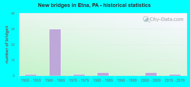
- New bridges - historical statistics
- 11950-1959
- 301960-1969
- 11970-1979
- 21980-1989
- 22000-2009
- 12010-2019
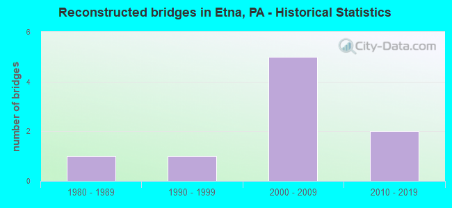
- Reconstructed bridges - Historical Statistics
- 11980-1989
- 11990-1999
- 52000-2009
- 22010-2019
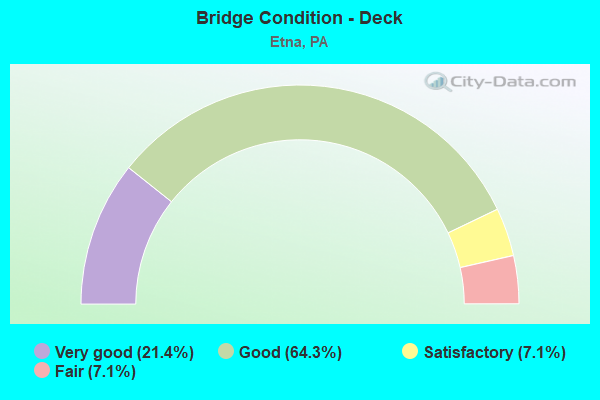
- Bridge Condition - Deck
- 21.4%Very good
- 64.3%Good
- 7.1%Satisfactory
- 7.1%Fair
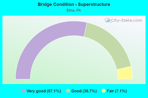
- Bridge Condition - Superstructure
- 57.1%Very good
- 35.7%Good
- 7.1%Fair
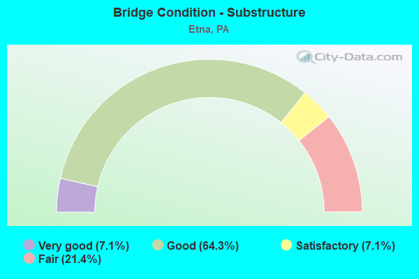
- Bridge Condition - Substructure
- 7.1%Very good
- 64.3%Good
- 7.1%Satisfactory
- 21.4%Fair
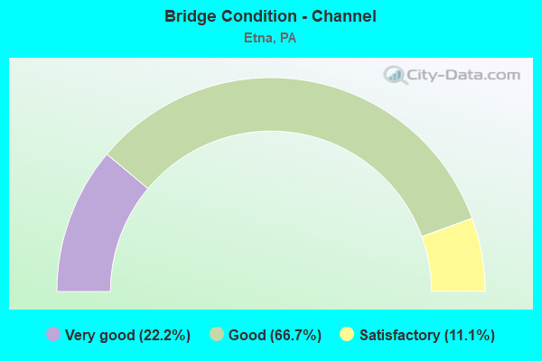
- Bridge Condition - Channel
- 22.2%Very good
- 66.7%Good
- 11.1%Satisfactory
Find on map >> Show street view
Structure Number: 491, Location: 62nd Street Bridge (Lat: 40.495872, Lng: -79.939842), Route carried "on" structure: State highway 8, Year Built: 1960, Year Reconstructed: 2008, Status: Open, Structure Length: 23.53m (77.20ft), Average Daily Traffic: 16,758 (year 2022), Truck Traffic: 10%, Average Future Daily Traffic: 12,346 (year 2032), Design Load: HS 20, Features Intersected: RT.28,RAILROAD,LOCAL ST.
Minimum Vertical Clearance: 4.60m (15.09ft), Kilometerpoint: 10.678, Lanes on structure: 2, Lanes under structure: 5, Base Highway Network: Yes, Owner: State Highway Agency, Approaching Roadway Width: 5.8m (19.0ft), Skew: 9 degrees, Material/Design: Steel, Design/Construction: Stringer/Multi-beam, Number Of Spans In Main Unit: 11, Length of Maximum Span: 26.8m (87.9ft), Curb or Sidewalk Widths: Left: 0.2m (0.7ft), Right: 0.2m (0.7ft), Curb-To-Curb Width: 6.0m (19.7ft), Out-to-Out Width: 7.1m (23.3ft)
Condition: Deck: Good, Superstructure: Good, Substructure: Fair, Operating Rating: 44.5 metric tons, Method Used To Determine Operating Rating: Load Factor (LF), Inventory Rating: 26.3 metric tons, Method Used To Determine Inventory Rating: Load Factor (LF), Structural Evaluation: Somewhat better than minimum adequacy, Deck Geometry: High priority of replacement, Underclear: Somewhat better than minimum adequacy, Approach Roadway Alignment: Equal to present desirable criteria, Length Of Structure Improvement: 23.90m (78.41ft), Designated Inspection Frequency: Every 24 months, Critical Feature Inspection Frequency: Every 24 months, Inspection Date: October 2020, Critical Feature Inspection Date: October 2020, Bridge Improvement Cost: $102,000, Roadway Improvement Cost: $299,000, Total Project Cost: $1,372,000, Deck Structure Type: Concrete Cast-file-Place, Wearing Surface/Protective System: Wearing Surface: Monolithic Concrete, Deck Protection: Epoxy Coated Reinforcing
Find on map >> Show street view
Structure Number: 492, Location: 62nd Street Bridge (Lat: 40.495733, Lng: -79.940006), Route carried "on" structure: Ramp State highway 8, Year Built: 1960, Year Reconstructed: 1985, Status: Open, Structure Length: 21.28m (69.82ft), Average Daily Traffic: 16,107 (year 2022), Truck Traffic: 9%, Average Future Daily Traffic: 12,878 (year 2032), Design Load: HS 20, Features Intersected: 70 PAR 72 LOCAL RR
Minimum Vertical Clearance: 4.44m (14.57ft), Kilometerpoint: 10.678, Lanes on structure: 1, Lanes under structure: 21, Base Highway Network: Yes, Owner: State Highway Agency, Approaching Roadway Width: 6.4m (21.0ft), Skew: 9 degrees, Material/Design: Steel, Design/Construction: Stringer/Multi-beam, Number Of Spans In Main Unit: 11, Length of Maximum Span: 25.9m (85.0ft), Curb or Sidewalk Widths: Left: 0.2m (0.7ft), Right: 0.2m (0.7ft), Curb-To-Curb Width: 6.4m (21.0ft), Out-to-Out Width: 7.5m (24.6ft)
Condition: Deck: Good, Superstructure: Good, Substructure: Fair, Operating Rating: 41.7 metric tons, Method Used To Determine Operating Rating: Load Factor (LF), Inventory Rating: 25.4 metric tons, Method Used To Determine Inventory Rating: Load Factor (LF), Structural Evaluation: Somewhat better than minimum adequacy, Deck Geometry: Somewhat better than minimum adequacy, Underclear: High priority of corrective action, Approach Roadway Alignment: Equal to present desirable criteria, Length Of Structure Improvement: 21.80m (71.52ft), Designated Inspection Frequency: Every 24 months, Critical Feature Inspection Frequency: Every 24 months, Inspection Date: October 2020, Critical Feature Inspection Date: October 2020, Bridge Improvement Cost: $77,000, Roadway Improvement Cost: $226,000, Total Project Cost: $1,037,000, Deck Structure Type: Concrete Cast-file-Place, Wearing Surface/Protective System: Wearing Surface: Monolithic Concrete, Deck Protection: Epoxy Coated Reinforcing
Find on map >> Show street view
Structure Number: 594, Location: RT 0028 OVER BUTLER ST (Lat: 40.492167, Lng: -79.950414), Route carried "on" structure: State highway 28, Year Built: 1960, Year Reconstructed: 2005, Status: Open, Structure Length: 11.95m (39.21ft), Average Daily Traffic: 24,754 (year 2022), Truck Traffic: 7%, Average Future Daily Traffic: 33,638 (year 2032), Design Load: HS 20, Features Intersected: SR 1001 BUTLER ST.
Minimum Vertical Clearance: 30+ m (98+ ft), Kilometerpoint: 6.198, Lanes on structure: 2, Lanes under structure: 2, Base Highway Network: Yes, Owner: State Highway Agency, Approaching Roadway Width: 12.2m (40.0ft), Skew: 9 degrees, Material/Design: Steel, Design/Construction: Stringer/Multi-beam, Number Of Spans In Main Unit: 4, Length of Maximum Span: 36.6m (120.1ft), Curb or Sidewalk Widths: Left: 0.1m (0.3ft), Right: 0.1m (0.3ft), Curb-To-Curb Width: 12.2m (40.0ft), Out-to-Out Width: 13.3m (43.6ft)
Condition: Deck: Good, Superstructure: Good, Substructure: Good, Operating Rating: 67.1 metric tons, Method Used To Determine Operating Rating: Load Factor (LF), Inventory Rating: 40.8 metric tons, Method Used To Determine Inventory Rating: Load Factor (LF), Structural Evaluation: Better than present minimum criteria, Deck Geometry: Better than present minimum criteria, Underclear: Somewhat better than minimum adequacy, Approach Roadway Alignment: Equal to present desirable criteria, Length Of Structure Improvement: 11.90m (39.04ft), Designated Inspection Frequency: Every 24 months, Critical Feature Inspection Frequency: Every 24 months, Inspection Date: April 2020, Critical Feature Inspection Date: April 2020, Deck Structure Type: Concrete Cast-file-Place, Wearing Surface/Protective System: Wearing Surface: Monolithic Concrete, Deck Protection: Epoxy Coated Reinforcing
Find on map >> Show street view
Structure Number: 598, Location: @ ETNA INTERCHANGE (Lat: 40.495814, Lng: -79.939269), Route carried "on" structure: State highway 28, Year Built: 1960, Year Reconstructed: 2009, Status: Open, Structure Length: 26.70m (87.60ft), Average Daily Traffic: 30,912 (year 2022), Truck Traffic: 15%, Average Future Daily Traffic: 25,741 (year 2032), Design Load: HL 93, Features Intersected: SR.8 NB/SB,N.MAIN,RR SP.
Minimum Vertical Clearance: 30+ m (98+ ft), Kilometerpoint: 7.427, Lanes on structure: 2, Lanes under structure: 8, Base Highway Network: Yes, Owner: State Highway Agency, Approaching Roadway Width: 8.2m (26.9ft), Skew: 9 degrees, Material/Design: Steel, Design/Construction: Stringer/Multi-beam, Number Of Spans In Main Unit: 1, Number Of Approach Spans: 10, Length of Maximum Span: 36.0m (118.1ft), Curb or Sidewalk Widths: Left: 0.1m (0.3ft), Right: 0.1m (0.3ft), Curb-To-Curb Width: 7.3m (24.0ft), Out-to-Out Width: 10.8m (35.4ft)
Condition: Deck: Very good, Superstructure: Very good, Substructure: Very good, Channel: Very good, Operating Rating: 76.2 metric tons, Method Used To Determine Operating Rating: Load and Resistance Factor (LRFR), Inventory Rating: 59.0 metric tons, Method Used To Determine Inventory Rating: Load and Resistance Factor (LRFR), Structural Evaluation: Equal to present desirable criteria, Deck Geometry: High priority of replacement, Underclear: Superior to present desirable criteria, Waterway Adequacy: Superior to present desirable criteria, Approach Roadway Alignment: Equal to present desirable criteria, Length Of Structure Improvement: 26.70m (87.60ft), Designated Inspection Frequency: Every 24 months, Inspection Date: April 2020, Bridge Improvement Cost: $74,000, Roadway Improvement Cost: $217,000, Total Project Cost: $994,000, Deck Structure Type: Concrete Cast-file-Place, Wearing Surface/Protective System: Wearing Surface: Monolithic Concrete, Deck Protection: Epoxy Coated Reinforcing
Find on map >> Show street view
Structure Number: 599, Location: ETNA INTERCHANGE SB (Lat: 40.496153, Lng: -79.939367), Route carried "on" structure: State highway 28, Year Built: 1960, Year Reconstructed: 2001, Status: Open, Structure Length: 31.88m (104.59ft), Average Daily Traffic: 30,704 (year 2022), Truck Traffic: 7%, Average Future Daily Traffic: 27,086 (year 2032), Design Load: HS 25 or greater, Features Intersected: RT 8 NB/SB, RT 8 RMPS
Minimum Vertical Clearance: 30+ m (98+ ft), Kilometerpoint: 7.388, Lanes on structure: 1, Lanes under structure: 48, Base Highway Network: Yes, Owner: State Highway Agency, Approaching Roadway Width: 9.8m (32.2ft), Skew: 9 degrees, Material/Design: Steel continuous, Design/Construction: Stringer/Multi-beam, Number Of Spans In Main Unit: 11, Number Of Approach Spans: 1, Length of Maximum Span: 31.1m (102.0ft), Curb or Sidewalk Widths: Left: 0.2m (0.7ft), Right: 0.2m (0.7ft), Curb-To-Curb Width: 9.8m (32.2ft), Out-to-Out Width: 10.6m (34.8ft)
Condition: Deck: Satisfactory, Superstructure: Very good, Substructure: Good, Channel: Very good, Operating Rating: 74.4 metric tons, Method Used To Determine Operating Rating: Load Factor (LF), Inventory Rating: 44.5 metric tons, Method Used To Determine Inventory Rating: Load Factor (LF), Structural Evaluation: Better than present minimum criteria, Deck Geometry: Meets minimum limits, Underclear: High priority of corrective action, Waterway Adequacy: Superior to present desirable criteria, Approach Roadway Alignment: Equal to present desirable criteria, Length Of Structure Improvement: 31.90m (104.66ft), Designated Inspection Frequency: Every 24 months, Critical Feature Inspection Frequency: Every 24 months, Inspection Date: April 2020, Critical Feature Inspection Date: April 2020, Deck Structure Type: Concrete Cast-file-Place, Wearing Surface/Protective System: Wearing Surface: Monolithic Concrete, Deck Protection: Epoxy Coated Reinforcing
Find on map >> Show street view
Structure Number: 1954, Location: 150' S.E. OF SR 4017 (Lat: 40.503303, Lng: -79.948422), Route carried "on" structure: State highway , Year Built: 1979, Status: Open, Structure Length: 2.10m (6.89ft), Average Daily Traffic: 5,735 (year 2022), Truck Traffic: 5%, Average Future Daily Traffic: 16,197 (year 2032), Design Load: HS 20, Features Intersected: PINE CREEK, Facility Carried by Structure: CRESCENT STREET
Minimum Vertical Clearance: 30+ m (98+ ft), Kilometerpoint: 0.673, Lanes on structure: 2, Owner: State Highway Agency, Approaching Roadway Width: 9.8m (32.2ft), Skew: 3 degrees, Material/Design: Prestressed concrete, Design/Construction: Box Beam or Girders - Multiple, Number Of Spans In Main Unit: 1, Length of Maximum Span: 18.6m (61.0ft), Curb or Sidewalk Widths: Left: 2.1m (6.9ft), Right: 0.2m (0.7ft), Curb-To-Curb Width: 8.5m (27.9ft), Out-to-Out Width: 11.9m (39.0ft)
Condition: Deck: Very good, Superstructure: Good, Substructure: Good, Channel: Satisfactory, Operating Rating: 99.8 metric tons, Method Used To Determine Operating Rating: Load Factor (LF), Inventory Rating: 31.8 metric tons, Method Used To Determine Inventory Rating: Load Factor (LF), Structural Evaluation: Better than present minimum criteria, Deck Geometry: High priority of replacement, Waterway Adequacy: Equal to present minimum criteria, Approach Roadway Alignment: Equal to present desirable criteria, Length Of Structure Improvement: 2.10m (6.89ft), Designated Inspection Frequency: Every 24 months, Inspection Date: June 2020, Bridge Improvement Cost: $13,000, Roadway Improvement Cost: $41,000, Total Project Cost: $179,000, Deck Structure Type: Concrete Cast-file-Place, Wearing Surface/Protective System: Wearing Surface: Monolithic Concrete, Membrane: Preformed Fabric, Deck Protection: Epoxy Coated Reinforcing
Find on map >> Show street view
Structure Number: 2586, Location: 430001 GREELEY AVE BRIDGE (Lat: 40.503975, Lng: -79.955256), Route carried "on" structure: City street , Year Built: 1985, Year Reconstructed: 2019, Status: Posted for load, Structure Length: 1.19m (3.90ft), Average Daily Traffic: 250 (year 2018), Truck Traffic: 5%, Average Future Daily Traffic: 275 (year 2039), Design Load: HS 20, Features Intersected: LITTLE PINE CREEK WEST, Facility Carried by Structure: GREELEY AVENUE
Minimum Vertical Clearance: 30+ m (98+ ft), Kilometerpoint: 0.000, Lanes on structure: 2, Owner: City or Municipal Highway Agency, Approaching Roadway Width: 4.0m (13.1ft), Skew: 2 degrees, Material/Design: Steel, Design/Construction: Stringer/Multi-beam, Number Of Spans In Main Unit: 1, Length of Maximum Span: 11.0m (36.1ft), Curb or Sidewalk Widths: Left: 0.1m (0.3ft), Right: 0.1m (0.3ft), Curb-To-Curb Width: 5.3m (17.4ft), Out-to-Out Width: 6.1m (20.0ft)
Condition: Deck: Very good, Superstructure: Very good, Substructure: Satisfactory, Channel: Good, Operating Rating: 30.8 metric tons, Method Used To Determine Operating Rating: Load Factor (LF), Inventory Rating: 18.1 metric tons, Method Used To Determine Inventory Rating: Load Factor (LF), Structural Evaluation: Somewhat better than minimum adequacy, Deck Geometry: High priority of replacement, Waterway Adequacy: Equal to present minimum criteria, Approach Roadway Alignment: Equal to present minimum criteria, Bridge Posting: Required (Relationship of Operating Rating to Maximum Legal Load: 30.0 - 39.9% below), Length Of Structure Improvement: 1.10m (3.61ft), Designated Inspection Frequency: Every 24 months, Other Special Inspection Frequency: Every 12 months, Inspection Date: August 2021, Other Special Inspection Date: August 2021, Bridge Improvement Cost: $3,000, Roadway Improvement Cost: $25,000, Total Project Cost: $43,000, Deck Structure Type: Concrete Cast-file-Place, Wearing Surface/Protective System: Wearing Surface: Monolithic Concrete
Find on map >> Show street view
Structure Number: 2587, Location: 430002 DEWEY ST BRIDGE (Lat: 40.503306, Lng: -79.954514), Route carried "on" structure: City street , Year Built: 1981, Year Reconstructed: 2014, Status: Open, Structure Length: 1.31m (4.30ft), Average Daily Traffic: 500 (year 2018), Truck Traffic: 1%, Average Future Daily Traffic: 500 (year 2039), Design Load: HL 93, Features Intersected: LITTLE PINE CREEK, Facility Carried by Structure: DEWEY ST
Minimum Vertical Clearance: 30+ m (98+ ft), Kilometerpoint: 0.000, Lanes on structure: 2, Owner: City or Municipal Highway Agency, Approaching Roadway Width: 7.9m (25.9ft), Skew: 4 degrees, Material/Design: Prestressed concrete, Design/Construction: Box Beam or Girders - Single/Spread, Number Of Spans In Main Unit: 1, Length of Maximum Span: 12.8m (42.0ft), Curb or Sidewalk Widths: Left: 1.7m (5.6ft), Right: 1.5m (4.9ft), Curb-To-Curb Width: 8.0m (26.2ft), Out-to-Out Width: 11.8m (38.7ft)
Condition: Deck: Good, Superstructure: Very good, Substructure: Good, Channel: Good, Operating Rating: 48.9 metric tons, Method Used To Determine Operating Rating: Assigned ratings based on Load and Resistance Factor Design (LRFD) reported by rating factor (RF) using HL93 loadings, Inventory Rating: 37.9 metric tons, Method Used To Determine Inventory Rating: Assigned ratings based on Load and Resistance Factor Design (LRFD) reported by rating factor (RF) using HL93 loadings, Structural Evaluation: Better than present minimum criteria, Deck Geometry: Somewhat better than minimum adequacy, Waterway Adequacy: Equal to present desirable criteria, Approach Roadway Alignment: Equal to present desirable criteria, Length Of Structure Improvement: 1.30m (4.27ft), Designated Inspection Frequency: Every 24 months, Inspection Date: Febuary 2020, Bridge Improvement Cost: $29,000, Roadway Improvement Cost: $85,000, Total Project Cost: $389,000, Deck Structure Type: Concrete Cast-file-Place, Wearing Surface/Protective System: Wearing Surface: Monolithic Concrete, Deck Protection: Epoxy Coated Reinforcing
Find on map >> Show street view
Structure Number: 2588, Location: 430004 HAFNER ST BRIDGE (Lat: 40.494039, Lng: -79.941556), Route carried "on" structure: City street , Year Built: 1955, Status: Open, Structure Length: 3.38m (11.09ft), Average Daily Traffic: 100 (year 2021), Truck Traffic: 10%, Average Future Daily Traffic: 100 (year 2043), Design Load: HS 20, Features Intersected: PINE CREEK, Facility Carried by Structure: HAFNER ST
Minimum Vertical Clearance: 30+ m (98+ ft), Kilometerpoint: 0.000, Lanes on structure: 2, Owner: City or Municipal Highway Agency, Approaching Roadway Width: 4.9m (16.1ft), Skew: 1 degrees, Material/Design: Steel, Design/Construction: Stringer/Multi-beam, Number Of Spans In Main Unit: 1, Length of Maximum Span: 32.6m (107.0ft), Curb or Sidewalk Widths: Left: 0.2m (0.7ft), Right: 0.2m (0.7ft), Curb-To-Curb Width: 6.1m (20.0ft), Out-to-Out Width: 6.7m (22.0ft)
Condition: Deck: Fair, Superstructure: Fair, Substructure: Fair, Channel: Good, Operating Rating: 67.1 metric tons, Method Used To Determine Operating Rating: Load Factor (LF), Inventory Rating: 39.9 metric tons, Method Used To Determine Inventory Rating: Load Factor (LF), Structural Evaluation: Somewhat better than minimum adequacy, Deck Geometry: Somewhat better than minimum adequacy, Waterway Adequacy: Better than present minimum criteria, Approach Roadway Alignment: Somewhat better than minimum adequacy, Length Of Structure Improvement: 3.40m (11.15ft), Designated Inspection Frequency: Every 24 months, Inspection Date: July 2021, Bridge Improvement Cost: $10,000, Roadway Improvement Cost: $28,000, Total Project Cost: $129,000, Deck Structure Type: Concrete Cast-file-Place, Wearing Surface/Protective System: Wearing Surface: Monolithic Concrete
Find on map >> Show street view
Structure Number: 283, Location: ETNA-28 N.B. RAMP TO RT 8 (Lat: 40.491667, Lng: -79.941667), Route carried "on" structure: State highway , Year Built: 1963, Year Reconstructed: 2010, Status: Open, Structure Length: 15.97m (52.40ft), Average Daily Traffic: 6,769 (year 2022), Truck Traffic: 3%, Average Future Daily Traffic: 15,642 (year 2032), Design Load: HL 93, Features Intersected: RAMP, BRIDGE ST.,CSX R/R, Facility Carried by Structure: RAMP 28 NB TO 8 NB
Minimum Vertical Clearance: 30+ m (98+ ft), Kilometerpoint: 0.000, Lanes on structure: 1, Lanes under structure: 16, Base Highway Network: Yes, Owner: State Highway Agency, Approaching Roadway Width: 7.3m (24.0ft), Skew: 9 degrees, Material/Design: Steel continuous, Design/Construction: Stringer/Multi-beam, Number Of Spans In Main Unit: 6, Number Of Approach Spans: 1, Length of Maximum Span: 29.3m (96.1ft), Curb or Sidewalk Widths: Left: 0.2m (0.7ft), Right: 0.2m (0.7ft), Curb-To-Curb Width: 5.5m (18.0ft), Out-to-Out Width: 6.5m (21.3ft)
Condition: Deck: Good, Superstructure: Very good, Substructure: Good, Channel: Good, Operating Rating: 48.3 metric tons, Method Used To Determine Operating Rating: Assigned ratings based on Load and Resistance Factor Design (LRFD) reported by rating factor (RF) using HL93 loadings, Inventory Rating: 37.3 metric tons, Method Used To Determine Inventory Rating: Assigned ratings based on Load and Resistance Factor Design (LRFD) reported by rating factor (RF) using HL93 loadings, Structural Evaluation: Better than present minimum criteria, Deck Geometry: High priority of replacement, Underclear: High priority of corrective action, Waterway Adequacy: Superior to present desirable criteria, Approach Roadway Alignment: Better than present minimum criteria, Length Of Structure Improvement: 16.20m (53.15ft), Designated Inspection Frequency: Every 24 months, Critical Feature Inspection Frequency: Every 24 months, Inspection Date: April 2020, Critical Feature Inspection Date: April 2020, Bridge Improvement Cost: $132,000, Roadway Improvement Cost: $389,000, Total Project Cost: $1,782,000, Deck Structure Type: Concrete Cast-file-Place, Wearing Surface/Protective System: Wearing Surface: Monolithic Concrete, Deck Protection: Epoxy Coated Reinforcing
Find on map >> Show street view
Structure Number: 2831, Location: TR8-S.B.RAMP TO 28 (Lat: 40.496181, Lng: -79.940783), Route carried "on" structure: Ramp State highway , Year Built: 1963, Year Reconstructed: 2005, Status: Open, Structure Length: 17.22m (56.50ft), Average Daily Traffic: 7,761 (year 2022), Truck Traffic: 3%, Average Future Daily Traffic: 16,137 (year 2032), Design Load: HS 20, Features Intersected: RAMP U,BRIDGE ST,PINE CR, Facility Carried by Structure: RAMP B
Minimum Vertical Clearance: 30+ m (98+ ft), Kilometerpoint: 0.000, Lanes on structure: 1, Lanes under structure: 6, Base Highway Network: Yes, Owner: State Highway Agency, Approaching Roadway Width: 6.4m (21.0ft), Skew: 9 degrees, Material/Design: Steel continuous, Design/Construction: Stringer/Multi-beam, Number Of Spans In Main Unit: 6, Number Of Approach Spans: 1, Length of Maximum Span: 33.2m (108.9ft), Curb or Sidewalk Widths: Left: 0.1m (0.3ft), Right: 0.1m (0.3ft), Curb-To-Curb Width: 6.4m (21.0ft), Out-to-Out Width: 7.5m (24.6ft)
Condition: Deck: Good, Superstructure: Very good, Substructure: Good, Channel: Good, Operating Rating: 78.9 metric tons, Method Used To Determine Operating Rating: Load Factor (LF), Inventory Rating: 60.8 metric tons, Method Used To Determine Inventory Rating: Load Factor (LF), Structural Evaluation: Better than present minimum criteria, Deck Geometry: Somewhat better than minimum adequacy, Underclear: Somewhat better than minimum adequacy, Waterway Adequacy: Superior to present desirable criteria, Approach Roadway Alignment: Equal to present minimum criteria, Length Of Structure Improvement: 17.20m (56.43ft), Designated Inspection Frequency: Every 24 months, Critical Feature Inspection Frequency: Every 24 months, Inspection Date: October 2020, Critical Feature Inspection Date: October 2020, Bridge Improvement Cost: $141,000, Roadway Improvement Cost: $414,000, Total Project Cost: $1,899,000, Deck Structure Type: Concrete Cast-file-Place, Wearing Surface/Protective System: Wearing Surface: Monolithic Concrete, Deck Protection: Epoxy Coated Reinforcing
Find on map >> Show street view
Structure Number: 44079, Location: 200' W of rte 8 millvale (Lat: 40.505556, Lng: -79.950000), Route carried "on" structure: State highway , Year Built: 2007, Status: Open, Structure Length: 1.86m (6.10ft), Average Daily Traffic: 9,100 (year 2022), Truck Traffic: 3%, Average Future Daily Traffic: 9,009 (year 2032), Design Load: HS 20, Features Intersected: Pine Creek, Facility Carried by Structure: Grant Ave
Minimum Vertical Clearance: 30+ m (98+ ft), Kilometerpoint: 0.000, Lanes on structure: 3, Owner: State Highway Agency, Approaching Roadway Width: 13.4m (44.0ft), Skew: 5 degrees, Material/Design: Steel, Design/Construction: Stringer/Multi-beam, Number Of Spans In Main Unit: 1, Length of Maximum Span: 16.8m (55.1ft), Curb or Sidewalk Widths: Left: 1.8m (5.9ft), Right: 0.0m, Curb-To-Curb Width: 13.4m (44.0ft), Out-to-Out Width: 13.4m (44.0ft)
Condition: Deck: Good, Superstructure: Good, Substructure: Good, Channel: Good, Operating Rating: 91.6 metric tons, Method Used To Determine Operating Rating: Load Factor (LF), Inventory Rating: 54.4 metric tons, Method Used To Determine Inventory Rating: Load Factor (LF), Structural Evaluation: Better than present minimum criteria, Deck Geometry: Somewhat better than minimum adequacy, Waterway Adequacy: Equal to present minimum criteria, Approach Roadway Alignment: Better than present minimum criteria, Designated Inspection Frequency: Every 48 months, Inspection Date: April 2019, Deck Structure Type: Concrete Cast-file-Place, Wearing Surface/Protective System: Wearing Surface: Low Slump Concrete, Deck Protection: Epoxy Coated Reinforcing
Find on map >> Show street view
Structure Number: 46264, Location: 0.25 MI SOUTH OF SR 8 (Lat: 40.494169, Lng: -79.943047), Route carried "on" structure: State highway 28, Year Built: 2010, Status: Open, Structure Length: 5.58m (18.31ft), Average Daily Traffic: 23,016 (year 2022), Truck Traffic: 7%, Average Future Daily Traffic: 31,277 (year 2032), Design Load: HS 20, Features Intersected: CSX (AVRR)
Minimum Vertical Clearance: 30+ m (98+ ft), Kilometerpoint: 6.906, Lanes on structure: 3, Base Highway Network: Yes, Owner: State Highway Agency, Approaching Roadway Width: 17.1m (56.1ft), Skew: 5 degrees, Material/Design: Steel, Design/Construction: Stringer/Multi-beam, Number Of Spans In Main Unit: 1, Length of Maximum Span: 54.3m (178.1ft), Curb or Sidewalk Widths: Left: 0.2m (0.7ft), Right: 0.2m (0.7ft), Curb-To-Curb Width: 16.9m (55.4ft), Out-to-Out Width: 18.3m (60.0ft)
Condition: Deck: Good, Superstructure: Very good, Substructure: Good, Operating Rating: 86.2 metric tons, Method Used To Determine Operating Rating: Load Factor (LF), Inventory Rating: 50.8 metric tons, Method Used To Determine Inventory Rating: Load Factor (LF), Structural Evaluation: Better than present minimum criteria, Deck Geometry: Equal to present minimum criteria, Underclear: High priority of corrective action, Approach Roadway Alignment: Equal to present desirable criteria, Designated Inspection Frequency: Every 48 months, Inspection Date: October 2018, Deck Structure Type: Concrete Cast-file-Place, Wearing Surface/Protective System: Wearing Surface: Monolithic Concrete, Deck Protection: Epoxy Coated Reinforcing
Find on map >> Show street view
Structure Number: 46283, Location: 500' S of Etna interchng (Lat: 40.494242, Lng: -79.943128), Route carried "on" structure: State highway 28, Year Built: 2009, Status: Open, Structure Length: 7.96m (26.12ft), Average Daily Traffic: 24,754 (year 2022), Truck Traffic: 7%, Average Future Daily Traffic: 33,638 (year 2032), Design Load: HS 20, Features Intersected: CSX (AVRR)
Minimum Vertical Clearance: 30+ m (98+ ft), Kilometerpoint: 6.912, Lanes on structure: 2, Base Highway Network: Yes, Owner: State Highway Agency, Approaching Roadway Width: 20.7m (67.9ft), Skew: 6 degrees, Material/Design: Steel continuous, Design/Construction: Stringer/Multi-beam, Number Of Spans In Main Unit: 2, Length of Maximum Span: 39.6m (129.9ft), Curb or Sidewalk Widths: Left: 0.2m (0.7ft), Right: 0.2m (0.7ft), Curb-To-Curb Width: 16.8m (55.1ft), Out-to-Out Width: 17.7m (58.1ft)
Condition: Deck: Good, Superstructure: Very good, Substructure: Good, Operating Rating: 68.9 metric tons, Method Used To Determine Operating Rating: Load Factor (LF), Inventory Rating: 40.8 metric tons, Method Used To Determine Inventory Rating: Load Factor (LF), Structural Evaluation: Better than present minimum criteria, Deck Geometry: Superior to present desirable criteria, Underclear: High priority of corrective action, Approach Roadway Alignment: Equal to present desirable criteria, Designated Inspection Frequency: Every 48 months, Inspection Date: October 2018, Deck Structure Type: Concrete Cast-file-Place, Wearing Surface/Protective System: Wearing Surface: Monolithic Concrete, Deck Protection: Epoxy Coated Reinforcing
Find on map >> Show street view
Structure Number: 491, Location: 62nd Street Bridge (Lat: 40.495872, Lng: -79.939842), Route carried "under" structure: Ramp State highway , Year Built: 1960, Structure Length: 0. m, Average Daily Traffic: 3,644 (year 2022), Truck Traffic: 7%, Features Intersected: RT.28,RAILROAD,LOCAL ST., Facility Carried by Structure: SR 8 NB
Minimum Vertical Clearance: 8.05m (26.41ft), Kilometerpoint: 0.000, Lanes on structure: 2, Lanes under structure: 2, Material/Design: Steel, Design/Construction: Stringer/Multi-beam, Length of Maximum Span: 26.8m (87.9ft)
Find on map >> Show street view
Structure Number: 491, Location: 62nd Street Bridge (Lat: 40.495872, Lng: -79.939842), Route carried "under" structure: Ramp State highway , Year Built: 1960, Structure Length: 0. m, Average Daily Traffic: 5,268 (year 2022), Truck Traffic: 3%, Features Intersected: RT.28,RAILROAD,LOCAL ST., Facility Carried by Structure: SR 8 NB
Minimum Vertical Clearance: 5.23m (17.16ft), Kilometerpoint: 0.000, Lanes on structure: 2, Lanes under structure: 1, Material/Design: Steel, Design/Construction: Stringer/Multi-beam, Length of Maximum Span: 26.8m (87.9ft)
Find on map >> Show street view
Structure Number: 491, Location: 62nd Street Bridge (Lat: 40.495872, Lng: -79.939842), Route carried "under" structure: Ramp State highway , Year Built: 1960, Structure Length: 0. m, Average Daily Traffic: 6,290 (year 2020), Truck Traffic: 7%, Features Intersected: RT.28,RAILROAD,LOCAL ST., Facility Carried by Structure: SR 8 NB
Minimum Vertical Clearance: 8.05m (26.41ft), Kilometerpoint: 0.703, Lanes on structure: 2, Lanes under structure: 2, Material/Design: Steel, Design/Construction: Stringer/Multi-beam, Length of Maximum Span: 26.8m (87.9ft)
Find on map >> Show street view
Structure Number: 492, Location: 62nd Street Bridge (Lat: 40.495733, Lng: -79.940006), Route carried "under" structure: State highway , Year Built: 1960, Structure Length: 0. m, Average Daily Traffic: 3,958 (year 2021), Truck Traffic: 6%, Features Intersected: 70 PAR 72 LOCAL RR, Facility Carried by Structure: SR 8 SB
Minimum Vertical Clearance: 4.75m (15.58ft), Kilometerpoint: 0.703, Lanes on structure: 1, Lanes under structure: 7, Material/Design: Steel, Design/Construction: Stringer/Multi-beam, Length of Maximum Span: 25.9m (85.0ft)
Find on map >> Show street view
Structure Number: 492, Location: 62nd Street Bridge (Lat: 40.495733, Lng: -79.940006), Route carried "under" structure: Ramp State highway , Year Built: 1960, Structure Length: 0. m, Average Daily Traffic: 3,644 (year 2022), Truck Traffic: 7%, Features Intersected: 70 PAR 72 LOCAL RR, Facility Carried by Structure: SR 8 SB
Minimum Vertical Clearance: 8.05m (26.41ft), Kilometerpoint: 0.000, Lanes on structure: 1, Lanes under structure: 7, Material/Design: Steel, Design/Construction: Stringer/Multi-beam, Length of Maximum Span: 25.9m (85.0ft)
Find on map >> Show street view
Structure Number: 492, Location: 62nd Street Bridge (Lat: 40.495733, Lng: -79.940006), Route carried "under" structure: Ramp State highway , Year Built: 1960, Structure Length: 0. m, Average Daily Traffic: 3,879 (year 2022), Truck Traffic: 7%, Features Intersected: 70 PAR 72 LOCAL RR, Facility Carried by Structure: SR 8 SB
Minimum Vertical Clearance: 5.33m (17.49ft), Kilometerpoint: 0.000, Lanes on structure: 1, Lanes under structure: 7, Material/Design: Steel, Design/Construction: Stringer/Multi-beam, Length of Maximum Span: 25.9m (85.0ft)
Find on map >> Show street view
Structure Number: 594, Location: RT 0028 OVER BUTLER ST (Lat: 40.492167, Lng: -79.950414), Route carried "under" structure: State highway , Year Built: 1960, Structure Length: 0. m, Average Daily Traffic: 2,893 (year 2022), Truck Traffic: 4%, Features Intersected: SR 1001 BUTLER ST., Facility Carried by Structure: SR 0028 SB
Minimum Vertical Clearance: 4.52m (14.83ft), Kilometerpoint: 0.000, Lanes on structure: 2, Lanes under structure: 2, Material/Design: Steel, Design/Construction: Stringer/Multi-beam, Length of Maximum Span: 36.6m (120.1ft)
Find on map >> Show street view
Structure Number: 598, Location: @ ETNA INTERCHANGE (Lat: 40.495814, Lng: -79.939269), Route carried "under" structure: State highway 8, Year Built: 1960, Structure Length: 0. m, Average Daily Traffic: 16,107 (year 2022), Truck Traffic: 9%, Features Intersected: SR.8 NB/SB,N.MAIN,RR SP.
Minimum Vertical Clearance: 5.33m (17.49ft), Kilometerpoint: 10.678, Lanes on structure: 2, Lanes under structure: 2, Material/Design: Steel, Design/Construction: Stringer/Multi-beam, Length of Maximum Span: 36.0m (118.1ft)
Find on map >> Show street view
Structure Number: 598, Location: @ ETNA INTERCHANGE (Lat: 40.495814, Lng: -79.939269), Route carried "under" structure: State highway 8, Year Built: 1960, Structure Length: 0. m, Average Daily Traffic: 16,758 (year 2022), Truck Traffic: 10%, Features Intersected: SR.8 NB/SB,N.MAIN,RR SP.
Minimum Vertical Clearance: 5.31m (17.42ft), Kilometerpoint: 10.678, Lanes on structure: 2, Lanes under structure: 2, Material/Design: Steel, Design/Construction: Stringer/Multi-beam, Length of Maximum Span: 36.0m (118.1ft)
Find on map >> Show street view
Structure Number: 598, Location: @ ETNA INTERCHANGE (Lat: 40.495814, Lng: -79.939269), Route carried "under" structure: Ramp State highway , Year Built: 1960, Structure Length: 0. m, Average Daily Traffic: 3,958 (year 2021), Truck Traffic: 6%, Features Intersected: SR.8 NB/SB,N.MAIN,RR SP., Facility Carried by Structure: SR 28 NB
Minimum Vertical Clearance: 15.24m (50.00ft), Kilometerpoint: 0.703, Lanes on structure: 2, Lanes under structure: 2, Material/Design: Steel, Design/Construction: Stringer/Multi-beam, Length of Maximum Span: 36.0m (118.1ft)
Find on map >> Show street view
Structure Number: 598, Location: @ ETNA INTERCHANGE (Lat: 40.495814, Lng: -79.939269), Route carried "under" structure: Ramp State highway , Year Built: 1960, Structure Length: 0. m, Average Daily Traffic: 3,644 (year 2022), Truck Traffic: 7%, Features Intersected: SR.8 NB/SB,N.MAIN,RR SP., Facility Carried by Structure: SR 28 NB
Minimum Vertical Clearance: 15.24m (50.00ft), Kilometerpoint: 0.000, Lanes on structure: 2, Lanes under structure: 2, Material/Design: Steel, Design/Construction: Stringer/Multi-beam, Length of Maximum Span: 36.0m (118.1ft)
Find on map >> Show street view
Structure Number: 599, Location: ETNA INTERCHANGE SB (Lat: 40.496153, Lng: -79.939367), Route carried "under" structure: Ramp State highway , Year Built: 1960, Structure Length: 0. m, Average Daily Traffic: 5,268 (year 2022), Truck Traffic: 3%, Features Intersected: RT 8 NB/SB, RT 8 RMPS, Facility Carried by Structure: SR 28 SB
Minimum Vertical Clearance: 5.77m (18.93ft), Kilometerpoint: 0.000, Lanes on structure: 1, Lanes under structure: 8, Material/Design: Steel continuous, Design/Construction: Stringer/Multi-beam, Length of Maximum Span: 31.1m (102.0ft)
Find on map >> Show street view
Structure Number: 599, Location: ETNA INTERCHANGE SB (Lat: 40.496153, Lng: -79.939367), Route carried "under" structure: Ramp State highway 8, Year Built: 1960, Structure Length: 0. m, Average Daily Traffic: 16,758 (year 2022), Truck Traffic: 10%, Features Intersected: RT 8 NB/SB, RT 8 RMPS
Minimum Vertical Clearance: 6.35m (20.83ft), Kilometerpoint: 10.678, Lanes on structure: 1, Lanes under structure: 8, Material/Design: Steel continuous, Design/Construction: Stringer/Multi-beam, Length of Maximum Span: 31.1m (102.0ft)
Find on map >> Show street view
Structure Number: 599, Location: ETNA INTERCHANGE SB (Lat: 40.496153, Lng: -79.939367), Route carried "under" structure: Ramp State highway , Year Built: 1960, Structure Length: 0. m, Average Daily Traffic: 3,958 (year 2021), Truck Traffic: 6%, Features Intersected: RT 8 NB/SB, RT 8 RMPS, Facility Carried by Structure: SR 28 SB
Minimum Vertical Clearance: 14.94m (49.02ft), Kilometerpoint: 0.703, Lanes on structure: 1, Lanes under structure: 8, Material/Design: Steel continuous, Design/Construction: Stringer/Multi-beam, Length of Maximum Span: 31.1m (102.0ft)
Find on map >> Show street view
Structure Number: 599, Location: ETNA INTERCHANGE SB (Lat: 40.496153, Lng: -79.939367), Route carried "under" structure: Ramp State highway , Year Built: 1960, Structure Length: 0. m, Average Daily Traffic: 3,644 (year 2022), Truck Traffic: 7%, Features Intersected: RT 8 NB/SB, RT 8 RMPS, Facility Carried by Structure: SR 28 SB
Minimum Vertical Clearance: 4.47m (14.67ft), Kilometerpoint: 0.000, Lanes on structure: 1, Lanes under structure: 8, Material/Design: Steel continuous, Design/Construction: Stringer/Multi-beam, Length of Maximum Span: 31.1m (102.0ft)
Find on map >> Show street view
Structure Number: 599, Location: ETNA INTERCHANGE SB (Lat: 40.496153, Lng: -79.939367), Route carried "under" structure: Ramp State highway , Year Built: 1960, Structure Length: 0. m, Average Daily Traffic: 6,769 (year 2022), Truck Traffic: 3%, Features Intersected: RT 8 NB/SB, RT 8 RMPS, Facility Carried by Structure: SR 28 SB
Minimum Vertical Clearance: 5.77m (18.93ft), Kilometerpoint: 0.000, Lanes on structure: 1, Lanes under structure: 8, Material/Design: Steel continuous, Design/Construction: Stringer/Multi-beam, Length of Maximum Span: 31.1m (102.0ft)
Find on map >> Show street view
Structure Number: 599, Location: ETNA INTERCHANGE SB (Lat: 40.496153, Lng: -79.939367), Route carried "under" structure: Ramp State highway 8, Year Built: 1960, Structure Length: 0. m, Average Daily Traffic: 16,107 (year 2022), Truck Traffic: 9%, Features Intersected: RT 8 NB/SB, RT 8 RMPS
Minimum Vertical Clearance: 7.54m (24.74ft), Kilometerpoint: 10.678, Lanes on structure: 1, Lanes under structure: 8, Material/Design: Steel continuous, Design/Construction: Stringer/Multi-beam, Length of Maximum Span: 31.1m (102.0ft)
Find on map >> Show street view
Structure Number: 283, Location: ETNA-28 N.B. RAMP TO RT 8 (Lat: 40.491667, Lng: -79.941667), Route carried "under" structure: State highway , Year Built: 1963, Structure Length: 0. m, Average Daily Traffic: 3,958 (year 2021), Truck Traffic: 6%, Features Intersected: RAMP, BRIDGE ST.,CSX R/R, Facility Carried by Structure: RAMP 28 NB TO 8 NB
Minimum Vertical Clearance: 9.57m (31.40ft), Kilometerpoint: 0.703, Lanes on structure: 1, Lanes under structure: 5, Material/Design: Steel continuous, Design/Construction: Stringer/Multi-beam, Length of Maximum Span: 29.3m (96.1ft)
Find on map >> Show street view
Structure Number: 283, Location: ETNA-28 N.B. RAMP TO RT 8 (Lat: 40.491667, Lng: -79.941667), Route carried "under" structure: Ramp State highway , Year Built: 1963, Structure Length: 0. m, Average Daily Traffic: 3,794 (year 2022), Truck Traffic: 7%, Features Intersected: RAMP, BRIDGE ST.,CSX R/R, Facility Carried by Structure: RAMP 28 NB TO 8 NB
Minimum Vertical Clearance: 9.37m (30.74ft), Kilometerpoint: 0.000, Lanes on structure: 1, Lanes under structure: 1, Material/Design: Steel continuous, Design/Construction: Stringer/Multi-beam, Length of Maximum Span: 29.3m (96.1ft)
Find on map >> Show street view
Structure Number: 283, Location: ETNA-28 N.B. RAMP TO RT 8 (Lat: 40.491667, Lng: -79.941667), Route carried "under" structure: Ramp State highway 8, Year Built: 1963, Structure Length: 0. m, Average Daily Traffic: 16,107 (year 2022), Truck Traffic: 9%, Features Intersected: RAMP, BRIDGE ST.,CSX R/R
Minimum Vertical Clearance: 4.85m (15.91ft), Kilometerpoint: 10.678, Lanes on structure: 1, Lanes under structure: 5, Material/Design: Steel continuous, Design/Construction: Stringer/Multi-beam, Length of Maximum Span: 29.3m (96.1ft)
Find on map >> Show street view
Structure Number: 283, Location: ETNA-28 N.B. RAMP TO RT 8 (Lat: 40.491667, Lng: -79.941667), Route carried "under" structure: Ramp State highway , Year Built: 1963, Structure Length: 0. m, Average Daily Traffic: 5,268 (year 2022), Truck Traffic: 3%, Features Intersected: RAMP, BRIDGE ST.,CSX R/R, Facility Carried by Structure: RAMP 28 NB TO 8 NB
Minimum Vertical Clearance: 5.21m (17.09ft), Kilometerpoint: 0.000, Lanes on structure: 1, Lanes under structure: 5, Material/Design: Steel continuous, Design/Construction: Stringer/Multi-beam, Length of Maximum Span: 29.3m (96.1ft)
Find on map >> Show street view
Structure Number: 2831, Location: TR8-S.B.RAMP TO 28 (Lat: 40.496181, Lng: -79.940783), Route carried "under" structure: State highway , Year Built: 1963, Structure Length: 0. m, Average Daily Traffic: 3,958 (year 2021), Truck Traffic: 6%, Features Intersected: RAMP U,BRIDGE ST,PINE CR, Facility Carried by Structure: RAMP B
Minimum Vertical Clearance: 2.34m (7.68ft), Kilometerpoint: 0.703, Lanes on structure: 1, Lanes under structure: 3, Material/Design: Steel continuous, Design/Construction: Stringer/Multi-beam, Length of Maximum Span: 33.2m (108.9ft)
Find on map >> Show street view
Structure Number: 2831, Location: TR8-S.B.RAMP TO 28 (Lat: 40.496181, Lng: -79.940783), Route carried "under" structure: Ramp State highway , Year Built: 1963, Structure Length: 0. m, Average Daily Traffic: 3,794 (year 2022), Truck Traffic: 7%, Features Intersected: RAMP U,BRIDGE ST,PINE CR, Facility Carried by Structure: RAMP B
Minimum Vertical Clearance: 4.93m (16.17ft), Kilometerpoint: 0.000, Lanes on structure: 1, Lanes under structure: 3, Material/Design: Steel continuous, Design/Construction: Stringer/Multi-beam, Length of Maximum Span: 33.2m (108.9ft)