Bridge Statistics for Exton, Pennsylvania (PA)
Condition, Traffic, Stress, Structural Evaluation, Project Costs

- New bridges - historical statistics
- 11930-1939
- 231960-1969
- 361990-1999
- 42000-2009
- 32010-2019
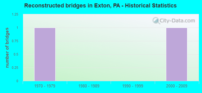
- Reconstructed bridges - Historical Statistics
- 11970-1979
- 01980-1989
- 01990-1999
- 12000-2009
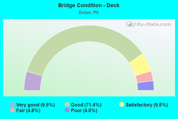
- Bridge Condition - Deck
- 9.5%Very good
- 71.4%Good
- 9.5%Satisfactory
- 4.8%Fair
- 4.8%Poor
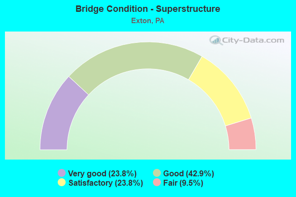
- Bridge Condition - Superstructure
- 23.8%Very good
- 42.9%Good
- 23.8%Satisfactory
- 9.5%Fair
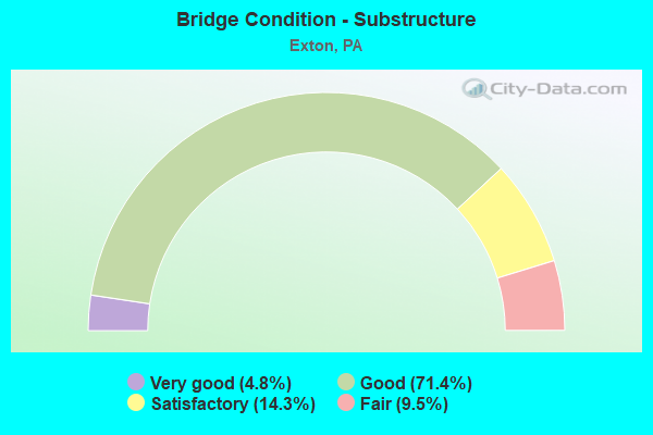
- Bridge Condition - Substructure
- 4.8%Very good
- 71.4%Good
- 14.3%Satisfactory
- 9.5%Fair
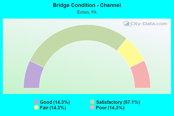
- Bridge Condition - Channel
- 14.3%Good
- 57.1%Satisfactory
- 14.3%Fair
- 14.3%Poor
Find on map >> Show street view
Structure Number: 9985, Location: CLOVER BUS PARK 31D1 (Lat: 40.013683, Lng: -75.653936), Route carried "on" structure: Bypass US 30, Year Built: 1995, Status: Open, Structure Length: 7.53m (24.70ft), Average Daily Traffic: 21,342 (year 2020), Truck Traffic: 12%, Average Future Daily Traffic: 35,640 (year 2032), Design Load: HS 25 or greater, Features Intersected: VALLEY CREEK, Facility Carried by Structure: EXTON BYPASS (EB)
Minimum Vertical Clearance: 30+ m (98+ ft), Kilometerpoint: 27.790, Lanes on structure: 2, Base Highway Network: Yes, Owner: State Highway Agency, Approaching Roadway Width: 12.2m (40.0ft), Skew: 11 degrees, Material/Design: Prestressed concrete continuous, Design/Construction: Stringer/Multi-beam, Number Of Spans In Main Unit: 2, Length of Maximum Span: 36.6m (120.1ft), Curb or Sidewalk Widths: Left: 0.2m (0.7ft), Right: 0.2m (0.7ft), Curb-To-Curb Width: 12.2m (40.0ft), Out-to-Out Width: 13.3m (43.6ft)
Condition: Deck: Good, Superstructure: Good, Substructure: Good, Channel: Satisfactory, Inventory Rating: 49.0 metric tons, Method Used To Determine Inventory Rating: Load Factor (LF), Structural Evaluation: Better than present minimum criteria, Deck Geometry: Better than present minimum criteria, Waterway Adequacy: Superior to present desirable criteria, Approach Roadway Alignment: Equal to present desirable criteria, Length Of Structure Improvement: 8.50m (27.89ft), Designated Inspection Frequency: Every 24 months, Inspection Date: June 2020, Deck Structure Type: Concrete Cast-file-Place, Wearing Surface/Protective System: Wearing Surface: Monolithic Concrete, Deck Protection: Epoxy Coated Reinforcing
Find on map >> Show street view
Structure Number: 9986, Location: CLOVER BUS PARK 31D01 (Lat: 40.013342, Lng: -75.652394), Route carried "on" structure: Bypass US 30, Year Built: 1995, Status: Open, Structure Length: 3.26m (10.70ft), Average Daily Traffic: 21,342 (year 2020), Truck Traffic: 12%, Average Future Daily Traffic: 35,640 (year 2032), Design Load: HS 25 or greater, Features Intersected: CLOVER MILL ROAD, Facility Carried by Structure: EXTON BYPASS(EB)
Minimum Vertical Clearance: 30+ m (98+ ft), Kilometerpoint: 27.790, Lanes on structure: 2, Lanes under structure: 2, Base Highway Network: Yes, Owner: State Highway Agency, Approaching Roadway Width: 13.1m (43.0ft), Skew: 13 degrees, Material/Design: Prestressed concrete, Design/Construction: Box Beam or Girders - Single/Spread, Number Of Spans In Main Unit: 1, Length of Maximum Span: 32.6m (107.0ft), Curb or Sidewalk Widths: Left: 0.2m (0.7ft), Right: 0.2m (0.7ft), Curb-To-Curb Width: 12.6m (41.3ft), Out-to-Out Width: 13.7m (44.9ft)
Condition: Deck: Good, Superstructure: Good, Substructure: Good, Inventory Rating: 45.4 metric tons, Method Used To Determine Inventory Rating: Load Factor (LF), Structural Evaluation: Better than present minimum criteria, Deck Geometry: Better than present minimum criteria, Underclear: Equal to present minimum criteria, Approach Roadway Alignment: Equal to present desirable criteria, Length Of Structure Improvement: 4.10m (13.45ft), Designated Inspection Frequency: Every 24 months, Inspection Date: June 2020, Deck Structure Type: Concrete Cast-file-Place, Wearing Surface/Protective System: Wearing Surface: Monolithic Concrete, Deck Protection: Epoxy Coated Reinforcing
Find on map >> Show street view
Structure Number: 9988, Location: CLOVER BUS PARK 31D01 (Lat: 40.013817, Lng: -75.653736), Route carried "on" structure: Bypass US 30, Year Built: 1995, Status: Open, Structure Length: 7.53m (24.70ft), Average Daily Traffic: 19,841 (year 2020), Truck Traffic: 11%, Average Future Daily Traffic: 33,386 (year 2032), Design Load: HS 25 or greater, Features Intersected: VALLEY CREEK, Facility Carried by Structure: EXTON BYPASS(WB)
Minimum Vertical Clearance: 30+ m (98+ ft), Kilometerpoint: 27.674, Lanes on structure: 2, Base Highway Network: Yes, Owner: State Highway Agency, Approaching Roadway Width: 12.2m (40.0ft), Skew: 11 degrees, Material/Design: Prestressed concrete continuous, Design/Construction: Stringer/Multi-beam, Number Of Spans In Main Unit: 2, Length of Maximum Span: 36.6m (120.1ft), Curb or Sidewalk Widths: Left: 0.2m (0.7ft), Right: 0.2m (0.7ft), Curb-To-Curb Width: 12.2m (40.0ft), Out-to-Out Width: 13.3m (43.6ft)
Condition: Deck: Good, Superstructure: Good, Substructure: Good, Channel: Satisfactory, Inventory Rating: 49.0 metric tons, Method Used To Determine Inventory Rating: Load Factor (LF), Structural Evaluation: Better than present minimum criteria, Deck Geometry: Better than present minimum criteria, Waterway Adequacy: Superior to present desirable criteria, Approach Roadway Alignment: Equal to present desirable criteria, Length Of Structure Improvement: 8.50m (27.89ft), Designated Inspection Frequency: Every 24 months, Inspection Date: June 2020, Deck Structure Type: Concrete Cast-file-Place, Wearing Surface/Protective System: Wearing Surface: Monolithic Concrete, Deck Protection: Epoxy Coated Reinforcing
Find on map >> Show street view
Structure Number: 9989, Location: CLOVER BUS PARK 31D01 (Lat: 40.013494, Lng: -75.652164), Route carried "on" structure: Bypass US 30, Year Built: 1995, Status: Open, Structure Length: 3.26m (10.70ft), Average Daily Traffic: 19,841 (year 2020), Truck Traffic: 11%, Average Future Daily Traffic: 33,386 (year 2032), Design Load: HS 25 or greater, Features Intersected: CLOVER MILL ROAD, Facility Carried by Structure: EXTON BYPASS(WB)
Minimum Vertical Clearance: 30+ m (98+ ft), Kilometerpoint: 27.674, Lanes on structure: 2, Lanes under structure: 2, Base Highway Network: Yes, Owner: State Highway Agency, Approaching Roadway Width: 13.1m (43.0ft), Skew: 13 degrees, Material/Design: Prestressed concrete, Design/Construction: Box Beam or Girders - Single/Spread, Number Of Spans In Main Unit: 1, Length of Maximum Span: 32.6m (107.0ft), Curb or Sidewalk Widths: Left: 0.2m (0.7ft), Right: 0.2m (0.7ft), Curb-To-Curb Width: 12.6m (41.3ft), Out-to-Out Width: 13.7m (44.9ft)
Condition: Deck: Good, Superstructure: Satisfactory, Substructure: Good, Inventory Rating: 42.6 metric tons, Method Used To Determine Inventory Rating: Load Factor (LF), Structural Evaluation: Equal to present minimum criteria, Deck Geometry: Better than present minimum criteria, Underclear: Meets minimum limits, Approach Roadway Alignment: Equal to present desirable criteria, Length Of Structure Improvement: 4.10m (13.45ft), Designated Inspection Frequency: Every 24 months, Inspection Date: June 2020, Bridge Improvement Cost: $13,000, Roadway Improvement Cost: $39,000, Total Project Cost: $178,000, Deck Structure Type: Concrete Cast-file-Place, Wearing Surface/Protective System: Wearing Surface: Monolithic Concrete, Deck Protection: Epoxy Coated Reinforcing
Find on map >> Show street view
Structure Number: 9992, Location: WHITFORD RD/SR6030 21F13 (Lat: 40.015408, Lng: -75.638481), Route carried "on" structure: Bypass US 30, Year Built: 1995, Status: Open, Structure Length: 3.32m (10.89ft), Average Daily Traffic: 21,342 (year 2020), Truck Traffic: 12%, Average Future Daily Traffic: 35,640 (year 2032), Design Load: HS 25 or greater, Features Intersected: WHITFORD ROAD, Facility Carried by Structure: EXTON BYPASS(EB)
Minimum Vertical Clearance: 30+ m (98+ ft), Kilometerpoint: 29.430, Lanes on structure: 2, Lanes under structure: 2, Base Highway Network: Yes, Owner: State Highway Agency, Approaching Roadway Width: 13.1m (43.0ft), Skew: 10 degrees, Material/Design: Prestressed concrete, Design/Construction: Box Beam or Girders - Multiple, Number Of Spans In Main Unit: 1, Length of Maximum Span: 33.2m (108.9ft), Curb or Sidewalk Widths: Left: 0.2m (0.7ft), Right: 0.2m (0.7ft), Curb-To-Curb Width: 12.6m (41.3ft), Out-to-Out Width: 13.7m (44.9ft)
Condition: Deck: Good, Superstructure: Good, Substructure: Good, Inventory Rating: 62.6 metric tons, Method Used To Determine Inventory Rating: Load Factor (LF), Structural Evaluation: Better than present minimum criteria, Deck Geometry: Better than present minimum criteria, Underclear: Somewhat better than minimum adequacy, Approach Roadway Alignment: Equal to present desirable criteria, Length Of Structure Improvement: 4.10m (13.45ft), Designated Inspection Frequency: Every 24 months, Inspection Date: August 2020, Deck Structure Type: Concrete Cast-file-Place, Wearing Surface/Protective System: Wearing Surface: Monolithic Concrete, Deck Protection: Epoxy Coated Reinforcing
Find on map >> Show street view
Structure Number: 9994, Location: WHITFORD RD/SR6030 21F13 (Lat: 40.015606, Lng: -75.638486), Route carried "on" structure: Bypass US 30, Year Built: 1995, Status: Open, Structure Length: 3.32m (10.89ft), Average Daily Traffic: 19,841 (year 2020), Truck Traffic: 11%, Average Future Daily Traffic: 33,386 (year 2032), Design Load: HS 25 or greater, Features Intersected: WHITFORD ROAD, Facility Carried by Structure: EXTON BYPASS(WB)
Minimum Vertical Clearance: 30+ m (98+ ft), Kilometerpoint: 29.353, Lanes on structure: 2, Lanes under structure: 2, Base Highway Network: Yes, Owner: State Highway Agency, Approaching Roadway Width: 13.1m (43.0ft), Skew: 10 degrees, Material/Design: Prestressed concrete, Design/Construction: Box Beam or Girders - Multiple, Number Of Spans In Main Unit: 1, Length of Maximum Span: 33.2m (108.9ft), Curb or Sidewalk Widths: Left: 0.2m (0.7ft), Right: 0.2m (0.7ft), Curb-To-Curb Width: 12.6m (41.3ft), Out-to-Out Width: 13.7m (44.9ft)
Condition: Deck: Good, Superstructure: Good, Substructure: Good, Inventory Rating: 60.8 metric tons, Method Used To Determine Inventory Rating: Load Factor (LF), Structural Evaluation: Better than present minimum criteria, Deck Geometry: Better than present minimum criteria, Underclear: Somewhat better than minimum adequacy, Approach Roadway Alignment: Equal to present desirable criteria, Length Of Structure Improvement: 4.10m (13.45ft), Designated Inspection Frequency: Every 24 months, Inspection Date: August 2020, Deck Structure Type: Concrete Cast-file-Place, Wearing Surface/Protective System: Wearing Surface: Monolithic Concrete, Deck Protection: Epoxy Coated Reinforcing
Find on map >> Show street view
Structure Number: 9996, Location: S RTE 100/30 21J12 (Lat: 40.020653, Lng: -75.624047), Route carried "on" structure: Bypass US 30, Year Built: 1995, Status: Open, Structure Length: 3.66m (12.01ft), Average Daily Traffic: 16,573 (year 2020), Truck Traffic: 14%, Average Future Daily Traffic: 25,894 (year 2032), Design Load: HS 25 or greater, Features Intersected: POTTSTOWN PIKE, Facility Carried by Structure: EXTON BYPASS(EB)
Minimum Vertical Clearance: 30+ m (98+ ft), Kilometerpoint: 30.454, Lanes on structure: 2, Lanes under structure: 12, Base Highway Network: Yes, Owner: State Highway Agency, Approaching Roadway Width: 12.2m (40.0ft), Skew: 10 degrees, Material/Design: Prestressed concrete, Design/Construction: Stringer/Multi-beam, Number Of Spans In Main Unit: 1, Length of Maximum Span: 35.1m (115.2ft), Curb or Sidewalk Widths: Left: 0.2m (0.7ft), Right: 0.2m (0.7ft), Curb-To-Curb Width: 12.2m (40.0ft), Out-to-Out Width: 13.3m (43.6ft)
Condition: Deck: Good, Superstructure: Satisfactory, Substructure: Good, Inventory Rating: 46.3 metric tons, Method Used To Determine Inventory Rating: Load Factor (LF), Structural Evaluation: Equal to present minimum criteria, Deck Geometry: Better than present minimum criteria, Underclear: Meets minimum limits, Approach Roadway Alignment: Equal to present desirable criteria, Length Of Structure Improvement: 4.60m (15.09ft), Designated Inspection Frequency: Every 24 months, Inspection Date: August 2020, Deck Structure Type: Concrete Cast-file-Place, Wearing Surface/Protective System: Wearing Surface: Monolithic Concrete, Deck Protection: Epoxy Coated Reinforcing
Find on map >> Show street view
Structure Number: 9997, Location: S RTE 100/30 21J12 (Lat: 40.020842, Lng: -75.624150), Route carried "on" structure: Bypass US 30, Year Built: 1995, Status: Open, Structure Length: 3.66m (12.01ft), Average Daily Traffic: 15,730 (year 2020), Truck Traffic: 14%, Average Future Daily Traffic: 25,410 (year 2032), Design Load: HS 25 or greater, Features Intersected: POTTSTOWN PIKE, Facility Carried by Structure: EXTON BYPASS(WB)RM
Minimum Vertical Clearance: 30+ m (98+ ft), Kilometerpoint: 30.405, Lanes on structure: 3, Lanes under structure: 6, Base Highway Network: Yes, Owner: State Highway Agency, Approaching Roadway Width: 18.0m (59.1ft), Skew: 10 degrees, Material/Design: Prestressed concrete, Design/Construction: Stringer/Multi-beam, Number Of Spans In Main Unit: 1, Length of Maximum Span: 35.1m (115.2ft), Curb or Sidewalk Widths: Left: 0.2m (0.7ft), Right: 0.2m (0.7ft), Curb-To-Curb Width: 18.5m (60.7ft), Out-to-Out Width: 19.6m (64.3ft)
Condition: Deck: Good, Superstructure: Good, Substructure: Good, Inventory Rating: 57.2 metric tons, Method Used To Determine Inventory Rating: Load Factor (LF), Structural Evaluation: Better than present minimum criteria, Deck Geometry: Superior to present desirable criteria, Underclear: Meets minimum limits, Approach Roadway Alignment: Equal to present desirable criteria, Length Of Structure Improvement: 4.60m (15.09ft), Designated Inspection Frequency: Every 24 months, Inspection Date: August 2020, Deck Structure Type: Concrete Cast-file-Place, Wearing Surface/Protective System: Wearing Surface: Monolithic Concrete, Deck Protection: Epoxy Coated Reinforcing
Find on map >> Show street view
Structure Number: 10001, Location: 1.25MI.E.RT 100 22A12 (Lat: 40.023922, Lng: -75.608981), Route carried "on" structure: Bypass US 30, Year Built: 1994, Status: Open, Structure Length: 2.87m (9.42ft), Average Daily Traffic: 16,573 (year 2020), Truck Traffic: 14%, Average Future Daily Traffic: 25,894 (year 2032), Design Load: HS 25 or greater, Features Intersected: SHIP ROAD, Facility Carried by Structure: EXTON BYPASS(EB)
Minimum Vertical Clearance: 30+ m (98+ ft), Kilometerpoint: 32.142, Lanes on structure: 2, Lanes under structure: 2, Base Highway Network: Yes, Owner: State Highway Agency, Approaching Roadway Width: 12.2m (40.0ft), Skew: 12 degrees, Material/Design: Prestressed concrete, Design/Construction: Stringer/Multi-beam, Number Of Spans In Main Unit: 1, Length of Maximum Span: 27.7m (90.9ft), Curb or Sidewalk Widths: Left: 0.2m (0.7ft), Right: 0.2m (0.7ft), Curb-To-Curb Width: 12.2m (40.0ft), Out-to-Out Width: 13.3m (43.6ft)
Condition: Deck: Good, Superstructure: Very good, Substructure: Good, Operating Rating: 92.5 metric tons, Method Used To Determine Operating Rating: Load Factor (LF), Inventory Rating: 46.3 metric tons, Method Used To Determine Inventory Rating: Load Factor (LF), Structural Evaluation: Better than present minimum criteria, Deck Geometry: Better than present minimum criteria, Underclear: Somewhat better than minimum adequacy, Approach Roadway Alignment: Equal to present desirable criteria, Length Of Structure Improvement: 3.60m (11.81ft), Designated Inspection Frequency: Every 24 months, Inspection Date: June 2020, Deck Structure Type: Concrete Cast-file-Place, Wearing Surface/Protective System: Wearing Surface: Monolithic Concrete, Deck Protection: Epoxy Coated Reinforcing
Find on map >> Show street view
Structure Number: 1006, Location: N OF BOOT ROAD 31K1 (Lat: 40.011522, Lng: -75.615625), Route carried "on" structure: State highway 100, Year Built: 1968, Year Reconstructed: 2009, Status: Open, Structure Length: 6.40m (21.00ft), Average Daily Traffic: 6,185 (year 2021), Truck Traffic: 7%, Average Future Daily Traffic: 11,793 (year 2032), Design Load: HS 20, Features Intersected: ROUTE 100, Facility Carried by Structure: POTTSTOWN PIKE
Minimum Vertical Clearance: 30+ m (98+ ft), Kilometerpoint: 13.979, Lanes on structure: 1, Lanes under structure: 4, Owner: State Highway Agency, Approaching Roadway Width: 8.5m (27.9ft), Skew: 4 degrees, Material/Design: Steel, Design/Construction: Stringer/Multi-beam, Number Of Spans In Main Unit: 1, Number Of Approach Spans: 2, Length of Maximum Span: 32.3m (106.0ft), Curb or Sidewalk Widths: Left: 0.2m (0.7ft), Right: 0.2m (0.7ft), Curb-To-Curb Width: 8.6m (28.2ft), Out-to-Out Width: 9.8m (32.2ft)
Condition: Deck: Fair, Superstructure: Satisfactory, Substructure: Good, Operating Rating: 64.4 metric tons, Method Used To Determine Operating Rating: Load Factor (LF), Inventory Rating: 39.0 metric tons, Method Used To Determine Inventory Rating: Load Factor (LF), Structural Evaluation: Equal to present minimum criteria, Deck Geometry: Meets minimum limits, Underclear: High priority of corrective action, Approach Roadway Alignment: Somewhat better than minimum adequacy, Length Of Structure Improvement: 7.40m (24.28ft), Designated Inspection Frequency: Every 24 months, Other Special Inspection Frequency: Every 12 months, Inspection Date: June 2020, Other Special Inspection Date: June 2021, Bridge Improvement Cost: $24,000, Roadway Improvement Cost: $70,000, Total Project Cost: $321,000, Deck Structure Type: Concrete Cast-file-Place, Wearing Surface/Protective System: Wearing Surface: Monolithic Concrete
Find on map >> Show street view
Structure Number: 10108, Location: NEAR WEST CHESTER 32D03 (Lat: 40.001772, Lng: -75.584442), Route carried "on" structure: US 202, Year Built: 1968, Status: Open, Structure Length: 1.58m (5.18ft), Average Daily Traffic: 23,045 (year 2021), Truck Traffic: 10%, Average Future Daily Traffic: 21,767 (year 2032), Design Load: HS 20, Features Intersected: GREEN HILL ROAD
Minimum Vertical Clearance: 30+ m (98+ ft), Kilometerpoint: 12.276, Lanes on structure: 2, Lanes under structure: 2, Base Highway Network: Yes, Owner: State Highway Agency, Approaching Roadway Width: 13.7m (44.9ft), Skew: 14 degrees, Material/Design: Steel, Design/Construction: Stringer/Multi-beam, Number Of Spans In Main Unit: 1, Length of Maximum Span: 15.2m (49.9ft), Curb or Sidewalk Widths: Left: 0.2m (0.7ft), Right: 0.2m (0.7ft), Curb-To-Curb Width: 12.2m (40.0ft), Out-to-Out Width: 13.4m (44.0ft)
Condition: Deck: Good, Superstructure: Good, Substructure: Fair, Operating Rating: 78.0 metric tons, Method Used To Determine Operating Rating: Load Factor (LF), Inventory Rating: 47.2 metric tons, Method Used To Determine Inventory Rating: Load Factor (LF), Structural Evaluation: Somewhat better than minimum adequacy, Deck Geometry: Better than present minimum criteria, Underclear: Meets minimum limits, Approach Roadway Alignment: Equal to present desirable criteria, Length Of Structure Improvement: 2.20m (7.22ft), Designated Inspection Frequency: Every 24 months, Inspection Date: July 2020, Deck Structure Type: Concrete Cast-file-Place, Wearing Surface/Protective System: Wearing Surface: Bituminous
Find on map >> Show street view
Structure Number: 1011, Location: 2.7MI.N.WEST CHES. 32E1 (Lat: 40.011381, Lng: -75.581333), Route carried "on" structure: State highway , Year Built: 1968, Status: Open, Structure Length: 5.55m (18.21ft), Average Daily Traffic: 1,515 (year 2022), Truck Traffic: 8%, Average Future Daily Traffic: 1,376 (year 2032), Design Load: HS 20, Features Intersected: TRAFFIC ROUTE 202, Facility Carried by Structure: MORSTEIN RD(T387)
Minimum Vertical Clearance: 30+ m (98+ ft), Kilometerpoint: 0.000, Lanes on structure: 2, Lanes under structure: 4, Owner: State Highway Agency, Approaching Roadway Width: 10.4m (34.1ft), Material/Design: Steel continuous, Design/Construction: Stringer/Multi-beam, Number Of Spans In Main Unit: 4, Length of Maximum Span: 17.4m (57.1ft), Curb or Sidewalk Widths: Left: 0.2m (0.7ft), Right: 0.2m (0.7ft), Curb-To-Curb Width: 9.0m (29.5ft), Out-to-Out Width: 10.2m (33.5ft)
Condition: Deck: Good, Superstructure: Fair, Substructure: Good, Operating Rating: 52.6 metric tons, Method Used To Determine Operating Rating: Load Factor (LF), Inventory Rating: 31.8 metric tons, Method Used To Determine Inventory Rating: Load Factor (LF), Structural Evaluation: Somewhat better than minimum adequacy, Deck Geometry: Somewhat better than minimum adequacy, Underclear: High priority of corrective action, Approach Roadway Alignment: Equal to present desirable criteria, Length Of Structure Improvement: 6.50m (21.33ft), Designated Inspection Frequency: Every 24 months, Inspection Date: July 2020, Bridge Improvement Cost: $10,000, Roadway Improvement Cost: $30,000, Total Project Cost: $137,000, Deck Structure Type: Concrete Cast-file-Place, Wearing Surface/Protective System: Wearing Surface: Monolithic Concrete
Find on map >> Show street view
Structure Number: 10402, Location: INDIAN KING 31K01 (Lat: 40.009489, Lng: -75.614378), Route carried "on" structure: State highway , Year Built: 1968, Status: Open, Structure Length: 2.87m (9.42ft), Average Daily Traffic: 12,498 (year 2022), Truck Traffic: 5%, Average Future Daily Traffic: 16,269 (year 2032), Design Load: HS 20, Features Intersected: PA 100 BYPASS TO SB 202, Facility Carried by Structure: BOOT ROAD
Minimum Vertical Clearance: 30+ m (98+ ft), Kilometerpoint: 7.809, Lanes on structure: 3, Lanes under structure: 4, Owner: State Highway Agency, Approaching Roadway Width: 12.5m (41.0ft), Skew: 3 degrees, Material/Design: Prestressed concrete, Design/Construction: Box Beam or Girders - Multiple, Number Of Spans In Main Unit: 1, Length of Maximum Span: 28.0m (91.9ft), Curb-To-Curb Width: 12.5m (41.0ft), Out-to-Out Width: 13.2m (43.3ft)
Condition: Deck: Very good, Superstructure: Good, Substructure: Good, Inventory Rating: 41.7 metric tons, Method Used To Determine Inventory Rating: Load Factor (LF), Structural Evaluation: Better than present minimum criteria, Deck Geometry: Meets minimum limits, Underclear: High priority of corrective action, Approach Roadway Alignment: Equal to present desirable criteria, Length Of Structure Improvement: 3.60m (11.81ft), Designated Inspection Frequency: Every 24 months, Inspection Date: May 2020, Bridge Improvement Cost: $32,000, Roadway Improvement Cost: $94,000, Total Project Cost: $432,000, Deck Structure Type: Concrete Cast-file-Place, Wearing Surface/Protective System: Wearing Surface: Monolithic Concrete, Deck Protection: Epoxy Coated Reinforcing
Find on map >> Show street view
Structure Number: 10403, Location: 2.5 MI.N. W. CHESTER 32E2 (Lat: 40.005483, Lng: -75.582394), Route carried "on" structure: State highway , Year Built: 1968, Status: Open, Structure Length: 5.88m (19.29ft), Average Daily Traffic: 23,361 (year 2022), Truck Traffic: 5%, Average Future Daily Traffic: 29,125 (year 2032), Design Load: HS 20, Features Intersected: US ROUTE 202, Facility Carried by Structure: BOOT ROAD
Minimum Vertical Clearance: 30+ m (98+ ft), Kilometerpoint: 10.174, Lanes on structure: 3, Lanes under structure: 4, Owner: State Highway Agency, Approaching Roadway Width: 12.5m (41.0ft), Material/Design: Prestressed concrete, Design/Construction: Box Beam or Girders - Single/Spread, Number Of Spans In Main Unit: 4, Length of Maximum Span: 17.4m (57.1ft), Curb-To-Curb Width: 12.2m (40.0ft), Out-to-Out Width: 13.4m (44.0ft)
Condition: Deck: Poor, Superstructure: Fair, Substructure: Fair, Operating Rating: 55.3 metric tons, Method Used To Determine Operating Rating: Load Factor (LF), Inventory Rating: 27.2 metric tons, Method Used To Determine Inventory Rating: Load Factor (LF), Structural Evaluation: Somewhat better than minimum adequacy, Deck Geometry: Meets minimum limits, Underclear: High priority of corrective action, Approach Roadway Alignment: Equal to present desirable criteria, Length Of Structure Improvement: 6.90m (22.64ft), Designated Inspection Frequency: Every 24 months, Inspection Date: September 2020, Bridge Improvement Cost: $57,000, Roadway Improvement Cost: $167,000, Total Project Cost: $766,000, Deck Structure Type: Concrete Cast-file-Place, Wearing Surface/Protective System: Wearing Surface: Bituminous
Find on map >> Show street view
Structure Number: 10558, Location: N.PA 100 & US 30 21H11 (Lat: 40.028308, Lng: -75.626597), Route carried "on" structure: US 30B, Year Built: 1999, Status: Open, Structure Length: 1.34m (4.40ft), Average Daily Traffic: 13,610 (year 2022), Truck Traffic: 7%, Average Future Daily Traffic: 18,726 (year 2032), Design Load: HS 25 or greater, Features Intersected: VALLEY CREEK, Facility Carried by Structure: E. LINCOLN HIGHWAY
Minimum Vertical Clearance: 30+ m (98+ ft), Kilometerpoint: 25.284, Lanes on structure: 3, Base Highway Network: Yes, Owner: State Highway Agency, Approaching Roadway Width: 26.5m (86.9ft), Material/Design: Concrete, Design/Construction: Culvert, Number Of Spans In Main Unit: 2, Length of Maximum Span: 6.1m (20.0ft), Curb-To-Curb Width: 26.5m (86.9ft), Out-to-Out Width: 27.7m (90.9ft)
Condition: Channel: Satisfactory, Culverts: Satisfactory, Operating Rating: 75.3 metric tons, Method Used To Determine Operating Rating: Load Factor (LF), Inventory Rating: 45.4 metric tons, Method Used To Determine Inventory Rating: Load Factor (LF), Structural Evaluation: Equal to present minimum criteria, Deck Geometry: Superior to present desirable criteria, Waterway Adequacy: Equal to present minimum criteria, Approach Roadway Alignment: Equal to present desirable criteria, Length Of Structure Improvement: 1.80m (5.91ft), Designated Inspection Frequency: Every 24 months, Inspection Date: September 2020, Bridge Improvement Cost: $49,000, Roadway Improvement Cost: $143,000, Total Project Cost: $657,000, Deck Structure Type: Concrete Precast Panels, Wearing Surface/Protective System: Wearing Surface: Monolithic Concrete, Deck Protection: Epoxy Coated Reinforcing
Find on map >> Show street view
Structure Number: 1085, Location: At Pa-100 3472-J4 (Lat: 40.039750, Lng: -75.634858), Route carried "on" structure: City street , Year Built: 1930, Year Reconstructed: 1978, Status: Posted for load, Structure Length: 1.28m (4.20ft), Average Daily Traffic: 3,500 (year 2015), Truck Traffic: 1%, Average Future Daily Traffic: 4,000 (year 2035), Design Load: HS 20, Features Intersected: BRANCH OF VALLEY CREEK, Facility Carried by Structure: SHOEN ROAD
Minimum Vertical Clearance: 30+ m (98+ ft), Kilometerpoint: 0.000, Lanes on structure: 2, Owner: Town or Township Highway Agency, Approaching Roadway Width: 10.1m (33.1ft), Skew: 4 degrees, Material/Design: Concrete, Design/Construction: Slab, Number Of Spans In Main Unit: 2, Length of Maximum Span: 5.8m (19.0ft), Curb or Sidewalk Widths: Left: 0.0m, Right: 1.8m (5.9ft), Curb-To-Curb Width: 10.1m (33.1ft), Out-to-Out Width: 12.2m (40.0ft)
Condition: Deck: Satisfactory, Superstructure: Satisfactory, Substructure: Satisfactory, Channel: Fair, Operating Rating: 31.8 metric tons, Method Used To Determine Operating Rating: Load Factor (LF), Inventory Rating: 19.1 metric tons, Method Used To Determine Inventory Rating: Load Factor (LF), Structural Evaluation: Somewhat better than minimum adequacy, Deck Geometry: Meets minimum limits, Waterway Adequacy: Meets minimum limits, Approach Roadway Alignment: Equal to present desirable criteria, Bridge Posting: Required (Relationship of Operating Rating to Maximum Legal Load: 30.0 - 39.9% below), Length Of Structure Improvement: 1.90m (6.23ft), Designated Inspection Frequency: Every 24 months, Other Special Inspection Frequency: Every 12 months, Inspection Date: May 2020, Other Special Inspection Date: May 2021, Roadway Improvement Cost: $3,000, Total Project Cost: $3,000, Deck Structure Type: Concrete Cast-file-Place, Wearing Surface/Protective System: Wearing Surface: Bituminous
Find on map >> Show street view
Structure Number: 10877, Location: 30/202 INTERCHNG 22D10 (Lat: 40.032183, Lng: -75.585014), Route carried "on" structure: Ramp State highway , Year Built: 1995, Status: Open, Structure Length: 9.33m (30.61ft), Average Daily Traffic: 15,697 (year 2022), Truck Traffic: 8%, Average Future Daily Traffic: 19,075 (year 2032), Design Load: HS 25 or greater, Features Intersected: RAMP Q;RAMP R, Facility Carried by Structure: RAMP EB
Minimum Vertical Clearance: 30+ m (98+ ft), Kilometerpoint: 0.000, Lanes on structure: 2, Lanes under structure: 2, Base Highway Network: Yes, Owner: State Highway Agency, Approaching Roadway Width: 12.2m (40.0ft), Material/Design: Steel continuous, Design/Construction: Stringer/Multi-beam, Number Of Spans In Main Unit: 2, Length of Maximum Span: 46.0m (150.9ft), Curb or Sidewalk Widths: Left: 0.2m (0.7ft), Right: 0.2m (0.7ft), Curb-To-Curb Width: 12.2m (40.0ft), Out-to-Out Width: 13.3m (43.6ft)
Condition: Deck: Satisfactory, Superstructure: Very good, Substructure: Good, Operating Rating: 77.1 metric tons, Method Used To Determine Operating Rating: Load Factor (LF), Inventory Rating: 46.3 metric tons, Method Used To Determine Inventory Rating: Load Factor (LF), Structural Evaluation: Better than present minimum criteria, Deck Geometry: Superior to present desirable criteria, Underclear: High priority of corrective action, Approach Roadway Alignment: Equal to present desirable criteria, Length Of Structure Improvement: 10.30m (33.79ft), Designated Inspection Frequency: Every 24 months, Inspection Date: July 2020, Deck Structure Type: Concrete Cast-file-Place, Wearing Surface/Protective System: Wearing Surface: Monolithic Concrete, Deck Protection: Epoxy Coated Reinforcing
Find on map >> Show street view
Structure Number: 10878, Location: 30/202 INTERCHNG 22D10 (Lat: 40.031667, Lng: -75.588367), Route carried "on" structure: Ramp State highway , Year Built: 1995, Status: Open, Structure Length: 8.93m (29.30ft), Average Daily Traffic: 16,270 (year 2022), Truck Traffic: 8%, Average Future Daily Traffic: 18,230 (year 2032), Design Load: HS 25 or greater, Features Intersected: US RTE 30, RAMP U, Facility Carried by Structure: RAMP T
Minimum Vertical Clearance: 30+ m (98+ ft), Kilometerpoint: 0.000, Lanes on structure: 1, Lanes under structure: 6, Base Highway Network: Yes, Owner: State Highway Agency, Approaching Roadway Width: 12.2m (40.0ft), Skew: 4 degrees, Material/Design: Steel continuous, Design/Construction: Stringer/Multi-beam, Number Of Spans In Main Unit: 2, Length of Maximum Span: 50.9m (167.0ft), Curb or Sidewalk Widths: Left: 0.2m (0.7ft), Right: 0.2m (0.7ft), Curb-To-Curb Width: 12.2m (40.0ft), Out-to-Out Width: 13.3m (43.6ft)
Condition: Deck: Good, Superstructure: Good, Substructure: Satisfactory, Operating Rating: 53.5 metric tons, Method Used To Determine Operating Rating: Load Factor (LF), Inventory Rating: 31.8 metric tons, Method Used To Determine Inventory Rating: Load Factor (LF), Structural Evaluation: Equal to present minimum criteria, Deck Geometry: Superior to present desirable criteria, Underclear: High priority of corrective action, Approach Roadway Alignment: Equal to present desirable criteria, Length Of Structure Improvement: 9.90m (32.48ft), Designated Inspection Frequency: Every 24 months, Inspection Date: July 2020, Deck Structure Type: Concrete Cast-file-Place, Wearing Surface/Protective System: Wearing Surface: Monolithic Concrete, Deck Protection: Epoxy Coated Reinforcing
Find on map >> Show street view
Structure Number: 10879, Location: 30/202 INTERCHNG 22D10 (Lat: 40.033117, Lng: -75.584461), Route carried "on" structure: Ramp State highway , Year Built: 1995, Status: Open, Structure Length: 5.46m (17.91ft), Average Daily Traffic: 15,697 (year 2022), Truck Traffic: 8%, Average Future Daily Traffic: 19,075 (year 2032), Design Load: HS 25 or greater, Features Intersected: ROUTE 30;RAMPS S & X, Facility Carried by Structure: RAMP EB
Minimum Vertical Clearance: 30+ m (98+ ft), Kilometerpoint: 0.000, Lanes on structure: 1, Lanes under structure: 6, Base Highway Network: Yes, Owner: State Highway Agency, Approaching Roadway Width: 12.2m (40.0ft), Skew: 3 degrees, Material/Design: Prestressed concrete continuous, Design/Construction: Box Beam or Girders - Single/Spread, Number Of Spans In Main Unit: 2, Length of Maximum Span: 26.5m (86.9ft), Curb or Sidewalk Widths: Left: 0.2m (0.7ft), Right: 0.2m (0.7ft), Curb-To-Curb Width: 12.2m (40.0ft), Out-to-Out Width: 13.3m (43.6ft)
Condition: Deck: Good, Superstructure: Satisfactory, Substructure: Good, Operating Rating: 89.8 metric tons, Method Used To Determine Operating Rating: Load Factor (LF), Inventory Rating: 49.9 metric tons, Method Used To Determine Inventory Rating: Load Factor (LF), Structural Evaluation: Equal to present minimum criteria, Deck Geometry: Superior to present desirable criteria, Underclear: Equal to present minimum criteria, Approach Roadway Alignment: Equal to present desirable criteria, Length Of Structure Improvement: 6.40m (21.00ft), Designated Inspection Frequency: Every 24 months, Inspection Date: July 2020, Deck Structure Type: Concrete Cast-file-Place, Wearing Surface/Protective System: Wearing Surface: Monolithic Concrete, Deck Protection: Epoxy Coated Reinforcing
Find on map >> Show street view
Structure Number: 4445, Location: .7MI.S.of PA 401 3474E02 (Lat: 40.043267, Lng: -75.570769), Route carried "on" structure: State highway , Year Built: 2008, Status: Open, Structure Length: 5.91m (19.39ft), Average Daily Traffic: 4,289 (year 2022), Truck Traffic: 1%, Average Future Daily Traffic: 5,835 (year 2032), Design Load: HL 93, Features Intersected: US 202 BYPASS, Facility Carried by Structure: SWEDESFORD ROAD
Minimum Vertical Clearance: 30+ m (98+ ft), Kilometerpoint: 0.702, Lanes on structure: 2, Lanes under structure: 8, Owner: State Highway Agency, Approaching Roadway Width: 11.6m (38.1ft), Skew: 3 degrees, Material/Design: Prestressed concrete continuous, Design/Construction: Box Beam or Girders - Single/Spread, Number Of Spans In Main Unit: 2, Length of Maximum Span: 29.0m (95.1ft), Curb or Sidewalk Widths: Left: 0.0m, Right: 1.5m (4.9ft), Curb-To-Curb Width: 13.4m (44.0ft), Out-to-Out Width: 15.8m (51.8ft)
Condition: Deck: Good, Superstructure: Very good, Substructure: Satisfactory, Operating Rating: 85.3 metric tons, Method Used To Determine Operating Rating: Load Factor (LF), Inventory Rating: 34.5 metric tons, Method Used To Determine Inventory Rating: Load Factor (LF), Structural Evaluation: Equal to present minimum criteria, Deck Geometry: Better than present minimum criteria, Underclear: High priority of corrective action, Approach Roadway Alignment: Better than present minimum criteria, Designated Inspection Frequency: Every 24 months, Inspection Date: September 2020, Deck Structure Type: Concrete Cast-file-Place, Wearing Surface/Protective System: Wearing Surface: Monolithic Concrete, Deck Protection: Epoxy Coated Reinforcing
Find on map >> Show street view
Structure Number: 47905, Location: 2.5 MI. W. PA29 3363G10 (Lat: 40.065106, Lng: -75.584544), Route carried "on" structure: State highway , Year Built: 2013, Status: Open, Structure Length: 5.64m (18.50ft), Average Daily Traffic: 750 (year 2022), Truck Traffic: 9%, Average Future Daily Traffic: 1,254 (year 2030), Design Load: HL 93, Features Intersected: PA TURNPIKE, Facility Carried by Structure: VALLEY HILL ROAD
Minimum Vertical Clearance: 30+ m (98+ ft), Kilometerpoint: 1.606, Lanes on structure: 2, Lanes under structure: 4, Owner: State Highway Agency, Approaching Roadway Width: 10.7m (35.1ft), Skew: 4 degrees, Material/Design: Steel continuous, Design/Construction: Stringer/Multi-beam, Number Of Spans In Main Unit: 2, Length of Maximum Span: 27.7m (90.9ft), Curb or Sidewalk Widths: Left: 0.2m (0.7ft), Right: 0.2m (0.7ft), Curb-To-Curb Width: 10.7m (35.1ft), Out-to-Out Width: 11.8m (38.7ft)
Condition: Deck: Good, Superstructure: Very good, Substructure: Good, Operating Rating: 54.8 metric tons, Method Used To Determine Operating Rating: Assigned ratings based on Load and Resistance Factor Design (LRFD) reported by rating factor (RF) using HL93 loadings, Inventory Rating: 34.3 metric tons, Method Used To Determine Inventory Rating: Assigned ratings based on Load and Resistance Factor Design (LRFD) reported by rating factor (RF) using HL93 loadings, Structural Evaluation: Better than present minimum criteria, Deck Geometry: Equal to present minimum criteria, Underclear: Superior to present desirable criteria, Approach Roadway Alignment: Better than present minimum criteria, Designated Inspection Frequency: Every 24 months, Inspection Date: December 2019, Deck Structure Type: Concrete Cast-file-Place, Wearing Surface/Protective System: Wearing Surface: Monolithic Concrete, Deck Protection: Epoxy Coated Reinforcing
Find on map >> Show street view
Structure Number: 52777, Location: 1 MI. N. US30 3473H04 (Lat: 40.041264, Lng: -75.576014), Route carried "on" structure: US 202, Year Built: 2016, Status: Open, Structure Length: 1.77m (5.81ft), Average Daily Traffic: 97,570 (year 2021), Truck Traffic: 6%, Average Future Daily Traffic: 85,700 (year 2032), Design Load: HL 93, Features Intersected: PLANEBROOK ROAD
Minimum Vertical Clearance: 30+ m (98+ ft), Kilometerpoint: 16.695, Lanes on structure: 4, Lanes under structure: 2, Base Highway Network: Yes, Owner: State Highway Agency, Approaching Roadway Width: 20.1m (65.9ft), Skew: 30 degrees, Material/Design: Prestressed concrete, Design/Construction: Stringer/Multi-beam, Number Of Spans In Main Unit: 1, Length of Maximum Span: 17.1m (56.1ft), Curb-To-Curb Width: 20.1m (65.9ft), Out-to-Out Width: 42.7m (140.1ft)
Condition: Deck: Very good, Superstructure: Very good, Substructure: Very good, Operating Rating: 58.3 metric tons, Method Used To Determine Operating Rating: Assigned ratings based on Load and Resistance Factor Design (LRFD) reported by rating factor (RF) using HL93 loadings, Inventory Rating: 36.6 metric tons, Method Used To Determine Inventory Rating: Assigned ratings based on Load and Resistance Factor Design (LRFD) reported by rating factor (RF) using HL93 loadings, Structural Evaluation: Equal to present desirable criteria, Deck Geometry: Equal to present minimum criteria, Underclear: Equal to present minimum criteria, Approach Roadway Alignment: Equal to present desirable criteria, Designated Inspection Frequency: Every 24 months, Inspection Date: April 2020, Deck Structure Type: Concrete Cast-file-Place, Wearing Surface/Protective System: Wearing Surface: Monolithic Concrete, Deck Protection: Epoxy Coated Reinforcing
Find on map >> Show street view
Structure Number: 54188, Location: W Phoenixvill Pk 3473 E10 (Lat: 40.003364, Lng: -75.594892), Route carried "on" structure: Other road , Year Built: 1990, Status: Open, Structure Length: 0.91m (2.99ft), Average Daily Traffic: 200 (year 2017), Truck Traffic: 3%, Average Future Daily Traffic: 416 (year 2032), Design Load: HS 20, Features Intersected: E Br of Chester Creek, Facility Carried by Structure: Bridgewater Drive
Minimum Vertical Clearance: 30+ m (98+ ft), Kilometerpoint: 0.000, Lanes on structure: 2, Owner: Town or Township Highway Agency, Approaching Roadway Width: 8.5m (27.9ft), Skew: 3 degrees, Material/Design: Concrete, Design/Construction: Culvert, Number Of Spans In Main Unit: 1, Length of Maximum Span: 9.1m (29.9ft)
Condition: Channel: Poor, Culverts: Satisfactory, Operating Rating: 79.8 metric tons, Method Used To Determine Operating Rating: Field evaluation and documented engineering judgment, Inventory Rating: 48.1 metric tons, Method Used To Determine Inventory Rating: Field evaluation and documented engineering judgment, Structural Evaluation: Equal to present minimum criteria, Waterway Adequacy: Better than present minimum criteria, Approach Roadway Alignment: Equal to present desirable criteria, Designated Inspection Frequency: Every 24 months, Inspection Date: May 2021
Find on map >> Show street view
Structure Number: 54222, Location: S.of Swedesford Rd 3473E5 (Lat: 40.037703, Lng: -75.594122), Route carried "on" structure: Other road , Year Built: 2002, Status: Open, Structure Length: 1.28m (4.20ft), Average Daily Traffic: 4,000 (year 2018), Truck Traffic: 4%, Average Future Daily Traffic: 4,881 (year 2038), Design Load: HL 93, Features Intersected: Valley Creek, Facility Carried by Structure: Valley Creek Blvd.
Minimum Vertical Clearance: 30+ m (98+ ft), Kilometerpoint: 0.000, Lanes on structure: 4, Owner: Town or Township Highway Agency, Approaching Roadway Width: 15.8m (51.8ft), Skew: 31 degrees, Material/Design: Concrete, Design/Construction: Culvert, Number Of Spans In Main Unit: 3, Length of Maximum Span: 3.7m (12.1ft), Curb or Sidewalk Widths: Left: 2.1m (6.9ft), Right: 1.1m (3.6ft), Curb-To-Curb Width: 15.8m (51.8ft), Out-to-Out Width: 25.3m (83.0ft)
Condition: Channel: Satisfactory, Culverts: Satisfactory, Operating Rating: 61.7 metric tons, Method Used To Determine Operating Rating: Field evaluation and documented engineering judgment, Inventory Rating: 37.2 metric tons, Method Used To Determine Inventory Rating: Field evaluation and documented engineering judgment, Structural Evaluation: Equal to present minimum criteria, Deck Geometry: Meets minimum limits, Waterway Adequacy: Better than present minimum criteria, Approach Roadway Alignment: Equal to present desirable criteria, Designated Inspection Frequency: Every 24 months, Inspection Date: March 2021
Find on map >> Show street view
Structure Number: 54223, Location: W of Kimberwyck Ln 3472J5 (Lat: 40.033269, Lng: -75.635450), Route carried "on" structure: Other road , Year Built: 1990, Status: Open, Structure Length: 1.01m (3.31ft), Average Daily Traffic: 3,200 (year 2018), Truck Traffic: 3%, Average Future Daily Traffic: 3,905 (year 2038), Design Load: HS 20, Features Intersected: Br.of Valley Creek, Facility Carried by Structure: Waterloo Blvd.
Minimum Vertical Clearance: 30+ m (98+ ft), Kilometerpoint: 0.000, Lanes on structure: 3, Owner: Town or Township Highway Agency, Approaching Roadway Width: 12.5m (41.0ft), Skew: 4 degrees, Material/Design: Concrete, Design/Construction: Culvert, Number Of Spans In Main Unit: 2, Length of Maximum Span: 3.7m (12.1ft), Curb or Sidewalk Widths: Left: 1.2m (3.9ft), Right: 1.2m (3.9ft), Curb-To-Curb Width: 12.5m (41.0ft), Out-to-Out Width: 30.8m (101.0ft)
Condition: Channel: Good, Culverts: Satisfactory, Operating Rating: 57.2 metric tons, Method Used To Determine Operating Rating: Field evaluation and documented engineering judgment, Inventory Rating: 33.6 metric tons, Method Used To Determine Inventory Rating: Field evaluation and documented engineering judgment, Structural Evaluation: Equal to present minimum criteria, Deck Geometry: Meets minimum limits, Waterway Adequacy: Better than present minimum criteria, Approach Roadway Alignment: Equal to present desirable criteria, Designated Inspection Frequency: Every 24 months, Inspection Date: March 2021
Find on map >> Show street view
Structure Number: 9986, Location: CLOVER BUS PARK 31D01 (Lat: 40.013342, Lng: -75.652394), Route carried "under" structure: City street 7254, Year Built: 1995, Structure Length: 0. m, Features Intersected: CLOVER MILL ROAD, Facility Carried by Structure: EXTON BYPASS(EB)
Minimum Vertical Clearance: 4.78m (15.68ft), Kilometerpoint: 0.000, Lanes on structure: 2, Lanes under structure: 2, Material/Design: Prestressed concrete, Design/Construction: Box Beam or Girders - Single/Spread, Length of Maximum Span: 32.6m (107.0ft)
Find on map >> Show street view
Structure Number: 9989, Location: CLOVER BUS PARK 31D01 (Lat: 40.013494, Lng: -75.652164), Route carried "under" structure: City street , Year Built: 1995, Structure Length: 0. m, Features Intersected: CLOVER MILL ROAD, Facility Carried by Structure: EXTON BYPASS(WB)
Minimum Vertical Clearance: 4.34m (14.24ft), Kilometerpoint: 0.000, Lanes on structure: 2, Lanes under structure: 2, Material/Design: Prestressed concrete, Design/Construction: Box Beam or Girders - Single/Spread, Length of Maximum Span: 32.6m (107.0ft)
Find on map >> Show street view
Structure Number: 9992, Location: WHITFORD RD/SR6030 21F13 (Lat: 40.015408, Lng: -75.638481), Route carried "under" structure: State highway , Year Built: 1995, Structure Length: 0. m, Average Daily Traffic: 6,918 (year 2022), Truck Traffic: 4%, Features Intersected: WHITFORD ROAD, Facility Carried by Structure: EXTON BYPASS(EB)
Minimum Vertical Clearance: 4.62m (15.16ft), Kilometerpoint: 2.350, Lanes on structure: 2, Lanes under structure: 2, Material/Design: Prestressed concrete, Design/Construction: Box Beam or Girders - Multiple, Length of Maximum Span: 33.2m (108.9ft)
Find on map >> Show street view
Structure Number: 9994, Location: WHITFORD RD/SR6030 21F13 (Lat: 40.015606, Lng: -75.638486), Route carried "under" structure: State highway , Year Built: 1995, Structure Length: 0. m, Average Daily Traffic: 6,918 (year 2022), Truck Traffic: 4%, Features Intersected: WHITFORD ROAD, Facility Carried by Structure: EXTON BYPASS(WB)
Minimum Vertical Clearance: 5.21m (17.09ft), Kilometerpoint: 2.350, Lanes on structure: 2, Lanes under structure: 2, Material/Design: Prestressed concrete, Design/Construction: Box Beam or Girders - Multiple, Length of Maximum Span: 33.2m (108.9ft)
Find on map >> Show street view
Structure Number: 9996, Location: S RTE 100/30 21J12 (Lat: 40.020653, Lng: -75.624047), Route carried "under" structure: State highway 100, Year Built: 1995, Structure Length: 0. m, Average Daily Traffic: 25,893 (year 2022), Truck Traffic: 4%, Features Intersected: POTTSTOWN PIKE, Facility Carried by Structure: EXTON BYPASS(EB)
Minimum Vertical Clearance: 5.05m (16.57ft), Kilometerpoint: 4.674, Lanes on structure: 2, Lanes under structure: 6, Material/Design: Prestressed concrete, Design/Construction: Stringer/Multi-beam, Length of Maximum Span: 35.1m (115.2ft)
Find on map >> Show street view
Structure Number: 9996, Location: S RTE 100/30 21J12 (Lat: 40.020653, Lng: -75.624047), Route carried "under" structure: State highway 100, Year Built: 1995, Structure Length: 0. m, Average Daily Traffic: 20,095 (year 2022), Truck Traffic: 8%, Features Intersected: POTTSTOWN PIKE, Facility Carried by Structure: EXTON BYPASS(EB)
Minimum Vertical Clearance: 4.62m (15.16ft), Kilometerpoint: 4.321, Lanes on structure: 2, Lanes under structure: 6, Material/Design: Prestressed concrete, Design/Construction: Stringer/Multi-beam, Length of Maximum Span: 35.1m (115.2ft)
Find on map >> Show street view
Structure Number: 9997, Location: S RTE 100/30 21J12 (Lat: 40.020842, Lng: -75.624150), Route carried "under" structure: State highway 100, Year Built: 1995, Structure Length: 0. m, Average Daily Traffic: 25,893 (year 2022), Truck Traffic: 4%, Features Intersected: POTTSTOWN PIKE, Facility Carried by Structure: EXTON BYPASS(WB)RM
Minimum Vertical Clearance: 5.28m (17.32ft), Kilometerpoint: 4.674, Lanes on structure: 3, Lanes under structure: 3, Material/Design: Prestressed concrete, Design/Construction: Stringer/Multi-beam, Length of Maximum Span: 35.1m (115.2ft)
Find on map >> Show street view
Structure Number: 9997, Location: S RTE 100/30 21J12 (Lat: 40.020842, Lng: -75.624150), Route carried "under" structure: State highway 100, Year Built: 1995, Structure Length: 0. m, Average Daily Traffic: 20,095 (year 2022), Truck Traffic: 8%, Features Intersected: POTTSTOWN PIKE, Facility Carried by Structure: EXTON BYPASS(WB)RM
Minimum Vertical Clearance: 4.88m (16.01ft), Kilometerpoint: 4.321, Lanes on structure: 3, Lanes under structure: 3, Material/Design: Prestressed concrete, Design/Construction: Stringer/Multi-beam, Length of Maximum Span: 35.1m (115.2ft)
Find on map >> Show street view
Structure Number: 10001, Location: 1.25MI.E.RT 100 22A12 (Lat: 40.023922, Lng: -75.608981), Route carried "under" structure: State highway , Year Built: 1994, Structure Length: 0. m, Average Daily Traffic: 7,911 (year 2022), Truck Traffic: 2%, Features Intersected: SHIP ROAD, Facility Carried by Structure: EXTON BYPASS(EB)
Minimum Vertical Clearance: 4.65m (15.26ft), Kilometerpoint: 2.234, Lanes on structure: 2, Lanes under structure: 2, Material/Design: Prestressed concrete, Design/Construction: Stringer/Multi-beam, Length of Maximum Span: 27.7m (90.9ft)
Find on map >> Show street view
Structure Number: 10003, Location: 1.25 E.RTE 100 22A12 (Lat: 40.024142, Lng: -75.608850), Route carried "under" structure: State highway , Year Built: 1994, Structure Length: 0. m, Average Daily Traffic: 7,911 (year 2022), Truck Traffic: 2%, Features Intersected: SHIP ROAD, Facility Carried by Structure: EXTON BYPASS(WB)
Minimum Vertical Clearance: 5.08m (16.67ft), Kilometerpoint: 2.234, Lanes on structure: 2, Lanes under structure: 2, Material/Design: Prestressed concrete, Design/Construction: Stringer/Multi-beam, Length of Maximum Span: 27.7m (90.9ft)
Find on map >> Show street view
Structure Number: 1006, Location: N OF BOOT ROAD 31K1 (Lat: 40.011522, Lng: -75.615625), Route carried "under" structure: Bypass State highway 100, Year Built: 1968, Structure Length: 0. m, Average Daily Traffic: 15,446 (year 2022), Truck Traffic: 12%, Features Intersected: ROUTE 100, Facility Carried by Structure: POTTSTOWN PIKE
Minimum Vertical Clearance: 4.44m (14.57ft), Kilometerpoint: 3.761, Lanes on structure: 1, Lanes under structure: 2, Material/Design: Steel, Design/Construction: Stringer/Multi-beam, Length of Maximum Span: 32.3m (106.0ft)
Find on map >> Show street view
Structure Number: 1006, Location: N OF BOOT ROAD 31K1 (Lat: 40.011522, Lng: -75.615625), Route carried "under" structure: Bypass State highway 100, Year Built: 1968, Structure Length: 0. m, Average Daily Traffic: 17,606 (year 2022), Truck Traffic: 16%, Features Intersected: ROUTE 100, Facility Carried by Structure: POTTSTOWN PIKE
Minimum Vertical Clearance: 4.40m (14.44ft), Kilometerpoint: 3.399, Lanes on structure: 1, Lanes under structure: 2, Material/Design: Steel, Design/Construction: Stringer/Multi-beam, Length of Maximum Span: 32.3m (106.0ft)
Find on map >> Show street view
Structure Number: 10108, Location: NEAR WEST CHESTER 32D03 (Lat: 40.001772, Lng: -75.584442), Route carried "under" structure: State highway , Year Built: 1968, Structure Length: 0. m, Average Daily Traffic: 8,738 (year 2022), Truck Traffic: 3%, Features Intersected: GREEN HILL ROAD, Facility Carried by Structure: TRAFFIC ROUTE 202
Minimum Vertical Clearance: 4.52m (14.83ft), Kilometerpoint: 2.060, Lanes on structure: 2, Lanes under structure: 2, Material/Design: Steel, Design/Construction: Stringer/Multi-beam, Length of Maximum Span: 15.2m (49.9ft)
Find on map >> Show street view
Structure Number: 10109, Location: NEAR WEST CHESTER 32D03 (Lat: 40.001628, Lng: -75.584764), Route carried "under" structure: State highway , Year Built: 1968, Structure Length: 0. m, Average Daily Traffic: 8,738 (year 2022), Truck Traffic: 3%, Features Intersected: GREEN HILL ROAD, Facility Carried by Structure: TRAFFIC ROUTE 202
Minimum Vertical Clearance: 5.15m (16.90ft), Kilometerpoint: 2.060, Lanes on structure: 2, Lanes under structure: 2, Material/Design: Steel, Design/Construction: Stringer/Multi-beam, Length of Maximum Span: 15.2m (49.9ft)
Find on map >> Show street view
Structure Number: 1011, Location: 2.7MI.N.WEST CHES. 32E1 (Lat: 40.011381, Lng: -75.581333), Route carried "under" structure: US 202, Year Built: 1968, Structure Length: 0. m, Average Daily Traffic: 15,148 (year 2020), Truck Traffic: 11%, Features Intersected: TRAFFIC ROUTE 202, Facility Carried by Structure: MORSTEIN RD(T387)
Minimum Vertical Clearance: 4.48m (14.70ft), Kilometerpoint: 13.433, Lanes on structure: 2, Lanes under structure: 2, Material/Design: Steel continuous, Design/Construction: Stringer/Multi-beam, Length of Maximum Span: 17.4m (57.1ft)
Find on map >> Show street view
Structure Number: 1011, Location: 2.7MI.N.WEST CHES. 32E1 (Lat: 40.011381, Lng: -75.581333), Route carried "under" structure: US 202, Year Built: 1968, Structure Length: 0. m, Average Daily Traffic: 14,850 (year 2020), Truck Traffic: 10%, Features Intersected: TRAFFIC ROUTE 202, Facility Carried by Structure: MORSTEIN RD(T387)
Minimum Vertical Clearance: 4.52m (14.83ft), Kilometerpoint: 13.398, Lanes on structure: 2, Lanes under structure: 2, Material/Design: Steel continuous, Design/Construction: Stringer/Multi-beam, Length of Maximum Span: 17.4m (57.1ft)
Find on map >> Show street view
Structure Number: 10111, Location: NEAR WEST CHESTER 22D13 (Lat: 40.019358, Lng: -75.585844), Route carried "under" structure: State highway , Year Built: 1968, Structure Length: 0. m, Average Daily Traffic: 5,120 (year 2022), Truck Traffic: 3%, Features Intersected: KING ROAD, Facility Carried by Structure: TRAFFIC ROUTE 202
Minimum Vertical Clearance: 4.42m (14.50ft), Kilometerpoint: 2.655, Lanes on structure: 2, Lanes under structure: 2, Material/Design: Steel continuous, Design/Construction: Stringer/Multi-beam, Length of Maximum Span: 13.7m (44.9ft)
Find on map >> Show street view
Structure Number: 10112, Location: NEAR WEST CHESTER 22D13 (Lat: 40.019267, Lng: -75.586072), Route carried "under" structure: State highway , Year Built: 1968, Structure Length: 0. m, Average Daily Traffic: 5,120 (year 2022), Truck Traffic: 3%, Features Intersected: KING ROAD, Facility Carried by Structure: TRAFFIC ROUTE 202
Minimum Vertical Clearance: 5.18m (16.99ft), Kilometerpoint: 2.655, Lanes on structure: 2, Lanes under structure: 2, Material/Design: Steel continuous, Design/Construction: Stringer/Multi-beam, Length of Maximum Span: 13.7m (44.9ft)
Find on map >> Show street view
Structure Number: 10113, Location: SOUTH OF RT. 30 22D11 (Lat: 40.029306, Lng: -75.587911), Route carried "under" structure: Ramp State highway , Year Built: 1969, Structure Length: 0. m, Average Daily Traffic: 15,697 (year 2022), Truck Traffic: 8%, Features Intersected: AMTRAK;RAMP EB;DUNWOODY, Facility Carried by Structure: ROUTE 202 (NB)
Minimum Vertical Clearance: 4.75m (15.58ft), Kilometerpoint: 0.000, Lanes on structure: 2, Lanes under structure: 2, Material/Design: Steel continuous, Design/Construction: Stringer/Multi-beam, Length of Maximum Span: 40.2m (131.9ft)
Find on map >> Show street view
Structure Number: 10113, Location: SOUTH OF RT. 30 22D11 (Lat: 40.029306, Lng: -75.587911), Route carried "under" structure: City street , Year Built: 1969, Structure Length: 0. m, Average Daily Traffic: 50 (year 2005), Truck Traffic: 1%, Features Intersected: AMTRAK;RAMP EB;DUNWOODY, Facility Carried by Structure: ROUTE 202 (NB)
Minimum Vertical Clearance: 6.10m (20.01ft), Kilometerpoint: 0.000, Lanes on structure: 2, Lanes under structure: 2, Material/Design: Steel continuous, Design/Construction: Stringer/Multi-beam, Length of Maximum Span: 40.2m (131.9ft)
Find on map >> Show street view
Structure Number: 10116, Location: SOUTH OF RT 30 22D11 (Lat: 40.028694, Lng: -75.588639), Route carried "under" structure: City street , Year Built: 1969, Structure Length: 0. m, Average Daily Traffic: 50 (year 2005), Truck Traffic: 1%, Features Intersected: AMTRAK;RAMP EB;DUNWOODY, Facility Carried by Structure: ROUTE 202 (SB)
Minimum Vertical Clearance: 6.45m (21.16ft), Kilometerpoint: 0.000, Lanes on structure: 2, Lanes under structure: 2, Material/Design: Steel continuous, Design/Construction: Stringer/Multi-beam, Length of Maximum Span: 39.3m (128.9ft)
Find on map >> Show street view
Structure Number: 10116, Location: SOUTH OF RT 30 22D11 (Lat: 40.028694, Lng: -75.588639), Route carried "under" structure: Ramp State highway , Year Built: 1969, Structure Length: 0. m, Average Daily Traffic: 15,697 (year 2022), Truck Traffic: 8%, Features Intersected: AMTRAK;RAMP EB;DUNWOODY, Facility Carried by Structure: ROUTE 202 (SB)
Minimum Vertical Clearance: 6.25m (20.51ft), Kilometerpoint: 0.000, Lanes on structure: 2, Lanes under structure: 2, Material/Design: Steel continuous, Design/Construction: Stringer/Multi-beam, Length of Maximum Span: 39.3m (128.9ft)
Find on map >> Show street view
Structure Number: 10117, Location: 202/30 INTERCH 22D10 (Lat: 40.033069, Lng: -75.584931), Route carried "under" structure: US 30, Year Built: 1995, Structure Length: 0. m, Average Daily Traffic: 8,394 (year 2022), Truck Traffic: 6%, Features Intersected: RTE 30, RAMPS S & X, Facility Carried by Structure: US 202(NB), RAMP R
Minimum Vertical Clearance: 4.60m (15.09ft), Kilometerpoint: 34.263, Lanes on structure: 3, Lanes under structure: 3, Material/Design: Steel continuous, Design/Construction: Stringer/Multi-beam, Length of Maximum Span: 29.3m (96.1ft)
Find on map >> Show street view
Structure Number: 10117, Location: 202/30 INTERCH 22D10 (Lat: 40.033069, Lng: -75.584931), Route carried "under" structure: US 30, Year Built: 1995, Structure Length: 0. m, Average Daily Traffic: 6,684 (year 2022), Truck Traffic: 4%, Features Intersected: RTE 30, RAMPS S & X, Facility Carried by Structure: US 202(NB), RAMP R
Minimum Vertical Clearance: 5.39m (17.68ft), Kilometerpoint: 34.355, Lanes on structure: 3, Lanes under structure: 3, Material/Design: Steel continuous, Design/Construction: Stringer/Multi-beam, Length of Maximum Span: 29.3m (96.1ft)
Find on map >> Show street view
Structure Number: 10118, Location: 202/30 INTERCHANGE 22D10 (Lat: 40.032947, Lng: -75.585383), Route carried "under" structure: US 30, Year Built: 1994, Structure Length: 0. m, Average Daily Traffic: 6,684 (year 2022), Truck Traffic: 4%, Features Intersected: RTE 30, RAMPS S & X, Facility Carried by Structure: US 202(SB), RAMP W
Minimum Vertical Clearance: 6.07m (19.91ft), Kilometerpoint: 34.355, Lanes on structure: 3, Lanes under structure: 3, Material/Design: Steel continuous, Design/Construction: Stringer/Multi-beam, Length of Maximum Span: 29.3m (96.1ft)
Find on map >> Show street view
Structure Number: 10118, Location: 202/30 INTERCHANGE 22D10 (Lat: 40.032947, Lng: -75.585383), Route carried "under" structure: US 30, Year Built: 1994, Structure Length: 0. m, Average Daily Traffic: 8,394 (year 2022), Truck Traffic: 6%, Features Intersected: RTE 30, RAMPS S & X, Facility Carried by Structure: US 202(SB), RAMP W
Minimum Vertical Clearance: 5.64m (18.50ft), Kilometerpoint: 34.263, Lanes on structure: 3, Lanes under structure: 3, Material/Design: Steel continuous, Design/Construction: Stringer/Multi-beam, Length of Maximum Span: 29.3m (96.1ft)
Find on map >> Show street view
Structure Number: 10402, Location: INDIAN KING 31K01 (Lat: 40.009489, Lng: -75.614378), Route carried "under" structure: Bypass State highway 100, Year Built: 1968, Structure Length: 0. m, Average Daily Traffic: 15,446 (year 2022), Truck Traffic: 12%, Features Intersected: PA 100 BYPASS TO SB 202, Facility Carried by Structure: BOOT ROAD
Minimum Vertical Clearance: 5.41m (17.75ft), Kilometerpoint: 3.761, Lanes on structure: 3, Lanes under structure: 2, Material/Design: Prestressed concrete, Design/Construction: Box Beam or Girders - Multiple, Length of Maximum Span: 28.0m (91.9ft)
Find on map >> Show street view
Structure Number: 10402, Location: INDIAN KING 31K01 (Lat: 40.009489, Lng: -75.614378), Route carried "under" structure: Bypass State highway 100, Year Built: 1968, Structure Length: 0. m, Average Daily Traffic: 17,606 (year 2022), Truck Traffic: 16%, Features Intersected: PA 100 BYPASS TO SB 202, Facility Carried by Structure: BOOT ROAD
Minimum Vertical Clearance: 4.75m (15.58ft), Kilometerpoint: 3.399, Lanes on structure: 3, Lanes under structure: 2, Material/Design: Prestressed concrete, Design/Construction: Box Beam or Girders - Multiple, Length of Maximum Span: 28.0m (91.9ft)
Find on map >> Show street view
Structure Number: 10403, Location: 2.5 MI.N. W. CHESTER 32E2 (Lat: 40.005483, Lng: -75.582394), Route carried "under" structure: US 202, Year Built: 1968, Structure Length: 0. m, Average Daily Traffic: 15,148 (year 2020), Truck Traffic: 11%, Features Intersected: US ROUTE 202, Facility Carried by Structure: BOOT ROAD
Minimum Vertical Clearance: 4.54m (14.90ft), Kilometerpoint: 12.727, Lanes on structure: 3, Lanes under structure: 2, Material/Design: Prestressed concrete, Design/Construction: Box Beam or Girders - Single/Spread, Length of Maximum Span: 17.4m (57.1ft)
Find on map >> Show street view
Structure Number: 10403, Location: 2.5 MI.N. W. CHESTER 32E2 (Lat: 40.005483, Lng: -75.582394), Route carried "under" structure: US 202, Year Built: 1968, Structure Length: 0. m, Average Daily Traffic: 14,850 (year 2020), Truck Traffic: 10%, Features Intersected: US ROUTE 202, Facility Carried by Structure: BOOT ROAD
Minimum Vertical Clearance: 5.51m (18.08ft), Kilometerpoint: 12.728, Lanes on structure: 3, Lanes under structure: 2, Material/Design: Prestressed concrete, Design/Construction: Box Beam or Girders - Single/Spread, Length of Maximum Span: 17.4m (57.1ft)
Find on map >> Show street view
Structure Number: 10409, Location: 2M.N.WEST CHESTER 32B2 (Lat: 40.004578, Lng: -75.604025), Route carried "under" structure: Bypass State highway 100, Year Built: 1968, Structure Length: 0. m, Average Daily Traffic: 17,606 (year 2022), Truck Traffic: 16%, Features Intersected: ROUTE 100, Facility Carried by Structure: KIRKLAND AVE(T387)
Minimum Vertical Clearance: 4.44m (14.57ft), Kilometerpoint: 2.322, Lanes on structure: 2, Lanes under structure: 2, Material/Design: Steel, Design/Construction: Stringer/Multi-beam, Length of Maximum Span: 37.2m (122.0ft)
Find on map >> Show street view
Structure Number: 10409, Location: 2M.N.WEST CHESTER 32B2 (Lat: 40.004578, Lng: -75.604025), Route carried "under" structure: Bypass State highway 100, Year Built: 1968, Structure Length: 0. m, Average Daily Traffic: 15,446 (year 2022), Truck Traffic: 12%, Features Intersected: ROUTE 100, Facility Carried by Structure: KIRKLAND AVE(T387)
Minimum Vertical Clearance: 4.44m (14.57ft), Kilometerpoint: 2.696, Lanes on structure: 2, Lanes under structure: 2, Material/Design: Steel, Design/Construction: Stringer/Multi-beam, Length of Maximum Span: 37.2m (122.0ft)
Find on map >> Show street view
Structure Number: 10877, Location: 30/202 INTERCHNG 22D10 (Lat: 40.032183, Lng: -75.585014), Route carried "under" structure: Ramp State highway , Year Built: 1995, Structure Length: 0. m, Average Daily Traffic: 3,335 (year 2022), Truck Traffic: 8%, Features Intersected: RAMP Q;RAMP R, Facility Carried by Structure: RAMP EB
Minimum Vertical Clearance: 5.13m (16.83ft), Kilometerpoint: 0.000, Lanes on structure: 2, Lanes under structure: 1, Material/Design: Steel continuous, Design/Construction: Stringer/Multi-beam, Length of Maximum Span: 46.0m (150.9ft)