Bridge Statistics for Farmington, Connecticut (CT)
Condition, Traffic, Stress, Structural Evaluation, Project Costs
- National Bridge Inventory (NBI) Statistics
- 67Number of bridges
- 850ft / 259mTotal length
- $3,915,000Total costs
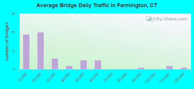
- 1,492,859Total average daily traffic
- 135,900Total average daily truck traffic
- National Bridge Inventory (NBI) Registered Bridges for Farmington
- No street view available for this location
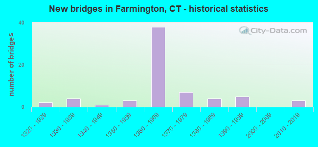
- New bridges - historical statistics
- 21920-1929
- 41930-1939
- 11940-1949
- 31950-1959
- 381960-1969
- 71970-1979
- 41980-1989
- 51990-1999
- 32010-2019
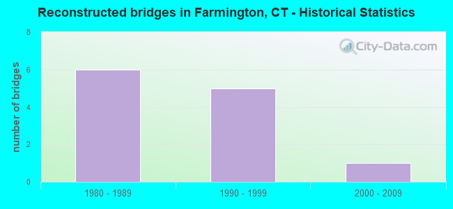
- Reconstructed bridges - Historical Statistics
- 61980-1989
- 51990-1999
- 12000-2009
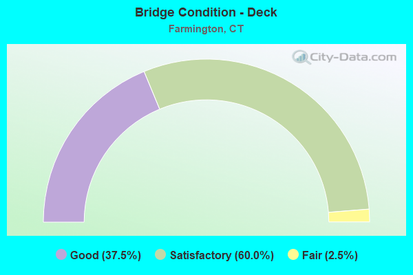
- Bridge Condition - Deck
- 37.5%Good
- 60.0%Satisfactory
- 2.5%Fair
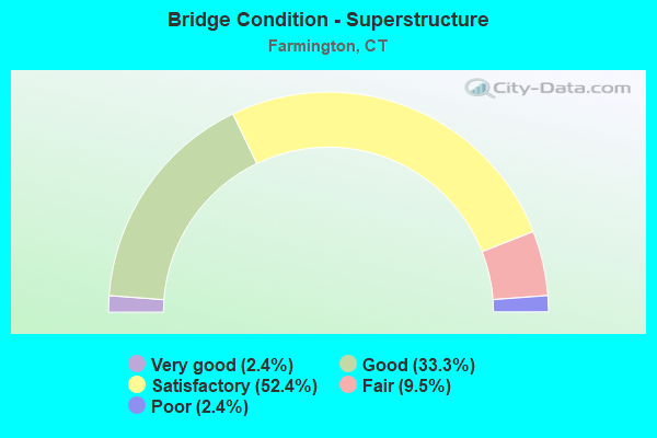
- Bridge Condition - Superstructure
- 2.4%Very good
- 33.3%Good
- 52.4%Satisfactory
- 9.5%Fair
- 2.4%Poor
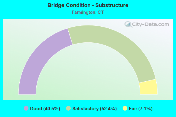
- Bridge Condition - Substructure
- 40.5%Good
- 52.4%Satisfactory
- 7.1%Fair
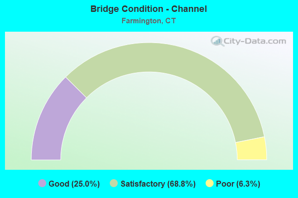
- Bridge Condition - Channel
- 25.0%Good
- 68.8%Satisfactory
- 6.3%Poor
Find on map >> Show street view
Structure Number: 6006, Location: 0.4 MI N WINDSOR LOCKS TL (Lat: 41.918883, Lng: -72.615617), Route carried "on" structure: Interstate 91, Year Built: 1959, Year Reconstructed: 1989, Status: Open, Structure Length: 4.39m (14.40ft), Average Daily Traffic: 54,800 (year 2015), Truck Traffic: 9%, Average Future Daily Traffic: 81,427 (year 2035), Design Load: HS 20, Features Intersected: SR 510 (MAIN STREET)
Minimum Vertical Clearance: 30+ m (98+ ft), Kilometerpoint: 80.709, Lanes on structure: 4, Lanes under structure: 2, Base Highway Network: Yes, Owner: State Highway Agency, Approaching Roadway Width: 20.1m (65.9ft), Material/Design: Steel continuous, Design/Construction: Stringer/Multi-beam, Number Of Spans In Main Unit: 3, Length of Maximum Span: 19.5m (64.0ft), Curb-To-Curb Width: 20.1m (65.9ft), Out-to-Out Width: 21.5m (70.5ft)
Condition: Deck: Good, Superstructure: Satisfactory, Substructure: Satisfactory, Operating Rating: 42.4 metric tons, Method Used To Determine Operating Rating: Load and Resistance Factor Rating (LRFR) rating reported by rating factor(RF) method using HL-93 loadings, Inventory Rating: 32.7 metric tons, Method Used To Determine Inventory Rating: Load and Resistance Factor Rating (LRFR) rating reported by rating factor(RF) method using HL-93 loadings, Structural Evaluation: Equal to present minimum criteria, Deck Geometry: Equal to present minimum criteria, Underclear: Somewhat better than minimum adequacy, Approach Roadway Alignment: Equal to present desirable criteria, Designated Inspection Frequency: Every 24 months, Inspection Date: October 2021, Deck Structure Type: Concrete Cast-file-Place, Wearing Surface/Protective System: Wearing Surface: Bituminous, Membrane: Built-up, Deck Protection: Epoxy Coated Reinforcing
Find on map >> Show street view
Structure Number: 6244, Location: 2000FT WEST OF RTE 10 INT (Lat: 41.704369, Lng: -72.850136), Route carried "on" structure: US 6, Year Built: 1993, Status: Open, Structure Length: 2.01m (6.59ft), Average Daily Traffic: 22,900 (year 2018), Truck Traffic: 4%, Average Future Daily Traffic: 34,027 (year 2038), Design Load: HS 20+Mod, Features Intersected: PEQUABUCK RIVER
Minimum Vertical Clearance: 30+ m (98+ ft), Kilometerpoint: 84.539, Lanes on structure: 4, Base Highway Network: Yes, Owner: State Highway Agency, Approaching Roadway Width: 20.7m (67.9ft), Skew: 1 degrees, Material/Design: Prestressed concrete, Design/Construction: Box Beam or Girders - Multiple, Number Of Spans In Main Unit: 1, Length of Maximum Span: 18.9m (62.0ft), Curb-To-Curb Width: 20.9m (68.6ft), Out-to-Out Width: 22.1m (72.5ft)
Condition: Deck: Satisfactory, Superstructure: Satisfactory, Substructure: Good, Channel: Satisfactory, Operating Rating: 35.0 metric tons, Method Used To Determine Operating Rating: Load and Resistance Factor Rating (LRFR) rating reported by rating factor(RF) method using HL-93 loadings, Inventory Rating: 25.9 metric tons, Method Used To Determine Inventory Rating: Load and Resistance Factor Rating (LRFR) rating reported by rating factor(RF) method using HL-93 loadings, Structural Evaluation: Equal to present minimum criteria, Deck Geometry: Superior to present desirable criteria, Waterway Adequacy: Equal to present desirable criteria, Approach Roadway Alignment: Equal to present desirable criteria, Designated Inspection Frequency: Every 24 months, Inspection Date: July 2020, Deck Structure Type: Other, Wearing Surface/Protective System: Wearing Surface: Bituminous, Membrane: Built-up, Deck Protection: Epoxy Coated Reinforcing
Find on map >> Show street view
Structure Number: 6245, Location: 0.1 MI.EAST OF ROUTE 177 (Lat: 41.706797, Lng: -72.877539), Route carried "on" structure: US 6, Year Built: 1992, Status: Open, Structure Length: 0.79m (2.59ft), Average Daily Traffic: 16,700 (year 2018), Truck Traffic: 4%, Average Future Daily Traffic: 24,815 (year 2038), Design Load: HS 20+Mod, Features Intersected: SCOTT SWAMP BROOK
Minimum Vertical Clearance: 30+ m (98+ ft), Kilometerpoint: 82.205, Lanes on structure: 4, Base Highway Network: Yes, Owner: State Highway Agency, Approaching Roadway Width: 18.6m (61.0ft), Material/Design: Prestressed concrete, Design/Construction: Slab, Number Of Spans In Main Unit: 1, Length of Maximum Span: 6.7m (22.0ft), Curb or Sidewalk Widths: Left: 1.7m (5.6ft), Right: 2.2m (7.2ft), Curb-To-Curb Width: 17.4m (57.1ft), Out-to-Out Width: 22.1m (72.5ft)
Condition: Deck: Good, Superstructure: Good, Substructure: Good, Channel: Satisfactory, Operating Rating: 37.9 metric tons, Method Used To Determine Operating Rating: Load and Resistance Factor Rating (LRFR) rating reported by rating factor(RF) method using HL-93 loadings, Inventory Rating: 29.2 metric tons, Method Used To Determine Inventory Rating: Load and Resistance Factor Rating (LRFR) rating reported by rating factor(RF) method using HL-93 loadings, Structural Evaluation: Better than present minimum criteria, Deck Geometry: Somewhat better than minimum adequacy, Waterway Adequacy: Equal to present desirable criteria, Approach Roadway Alignment: Equal to present desirable criteria, Designated Inspection Frequency: Every 24 months, Inspection Date: June 2021, Deck Structure Type: Other, Wearing Surface/Protective System: Wearing Surface: Bituminous, Membrane: Built-up, Deck Protection: Epoxy Coated Reinforcing
Find on map >> Show street view
Structure Number: 430R, Location: 2.1 MILES WEST OF RTE. 10 (Lat: 41.743267, Lng: -72.859364), Route carried "under" structure: State highway 4, Year Built: 1928, Structure Length: 0. m, Average Daily Traffic: 16,600 (year 2015), Truck Traffic: 6%, Features Intersected: ROUTE 4, Facility Carried by Structure: RAILS TO TRAILS
Minimum Vertical Clearance: 4.57m (14.99ft), Kilometerpoint: 65.355, Lanes under structure: 2, Material/Design: Steel, Design/Construction: Stringer/Multi-beam, Length of Maximum Span: 16.8m (55.1ft)
Find on map >> Show street view
Structure Number: 476, Location: 0.4 MILE EAST OF SR 552 (Lat: 41.708842, Lng: -72.841444), Route carried "under" structure: State highway 10, Year Built: 1933, Structure Length: 0. m, Average Daily Traffic: 13,100 (year 2018), Truck Traffic: 5%, Features Intersected: ROUTE 10, Facility Carried by Structure: US ROUTE 6
Minimum Vertical Clearance: 4.27m (14.01ft), Kilometerpoint: 52.062, Lanes on structure: 2, Lanes under structure: 2, Material/Design: Steel, Design/Construction: Stringer/Multi-beam, Length of Maximum Span: 32.6m (107.0ft)
Find on map >> Show street view
Structure Number: 3324, Location: ADJACENT TO I-84 EXIT 37 (Lat: 41.706922, Lng: -72.802192), Route carried "under" structure: Interstate 84, Year Built: 1967, Structure Length: 0. m, Average Daily Traffic: 88,900 (year 2018), Truck Traffic: 9%, Features Intersected: INTERSTATE-84, Facility Carried by Structure: FIENEMANN ROAD
Minimum Vertical Clearance: 4.88m (16.01ft), Kilometerpoint: 85.681, Lanes on structure: 4, Lanes under structure: 8, Material/Design: Steel, Design/Construction: Stringer/Multi-beam, Length of Maximum Span: 33.2m (108.9ft)
Find on map >> Show street view
Structure Number: 3482, Location: SOUTH OF FARMINGTON STACK (Lat: 41.723233, Lng: -72.771633), Route carried "under" structure: State highway 9, Year Built: 1969, Structure Length: 0. m, Average Daily Traffic: 23,000 (year 2015), Truck Traffic: 6%, Features Intersected: ROUTE 9 SOUTHBOUND, Facility Carried by Structure: SOUTH ROAD
Minimum Vertical Clearance: 5.31m (17.42ft), Kilometerpoint: 64.840, Lanes on structure: 2, Lanes under structure: 2, Material/Design: Steel continuous, Design/Construction: Stringer/Multi-beam, Length of Maximum Span: 32.8m (107.6ft)
Find on map >> Show street view
Structure Number: 3483, Location: FARMINGTON @STACK (Lat: 41.727011, Lng: -72.772225), Route carried "under" structure: Interstate 84, Year Built: 1969, Structure Length: 0. m, Average Daily Traffic: 104,200 (year 2018), Truck Traffic: 14%, Features Intersected: INTERSTATE-84, Facility Carried by Structure: VACANT ROUTE 9 SB
Minimum Vertical Clearance: 5.11m (16.77ft), Kilometerpoint: 89.302, Lanes on structure: 2, Lanes under structure: 6, Material/Design: Steel continuous, Design/Construction: Stringer/Multi-beam, Length of Maximum Span: 22.6m (74.1ft)
Find on map >> Show street view
Structure Number: 3484, Location: FARMINGTON STACK (Lat: 41.727019, Lng: -72.771953), Route carried "under" structure: Interstate 84, Year Built: 1969, Structure Length: 0. m, Average Daily Traffic: 104,200 (year 2018), Truck Traffic: 14%, Features Intersected: INTERSTATE-84, Facility Carried by Structure: VACANT ROUTE 9 NB
Minimum Vertical Clearance: 5.66m (18.57ft), Kilometerpoint: 89.319, Lanes on structure: 2, Lanes under structure: 6, Material/Design: Steel continuous, Design/Construction: Stringer/Multi-beam, Length of Maximum Span: 22.6m (74.1ft)
Find on map >> Show street view
Structure Number: 3492, Location: FOURTH LEVEL-EXIT 39A (Lat: 41.726886, Lng: -72.771728), Route carried "under" structure: Ramp State highway 9, Year Built: 1970, Structure Length: 0. m, Average Daily Traffic: 13,900 (year 2015), Truck Traffic: 9%, Features Intersected: I-84, I-84 TR 820,SR 506
Minimum Vertical Clearance: 5.41m (17.75ft), Kilometerpoint: 65.339, Lanes on structure: 1, Lanes under structure: 1, Material/Design: Steel, Design/Construction: Stringer/Multi-beam, Length of Maximum Span: 35.7m (117.1ft)
Find on map >> Show street view
Structure Number: 3492, Location: FOURTH LEVEL-EXIT 39A (Lat: 41.726886, Lng: -72.771728), Route carried "under" structure: Ramp State highway 506, Year Built: 1970, Structure Length: 0. m, Features Intersected: I-84, I-84 TR 820,SR 506, Facility Carried by Structure: VACANT RTE. 9 RAMP
Minimum Vertical Clearance: 5.82m (19.09ft), Lanes on structure: 1, Lanes under structure: 1, Material/Design: Steel, Design/Construction: Stringer/Multi-beam, Length of Maximum Span: 35.7m (117.1ft)
Find on map >> Show street view
Structure Number: 3492, Location: FOURTH LEVEL-EXIT 39A (Lat: 41.726886, Lng: -72.771728), Route carried "under" structure: Interstate 84, Year Built: 1970, Structure Length: 0. m, Average Daily Traffic: 52,100 (year 2018), Truck Traffic: 14%, Features Intersected: I-84, I-84 TR 820,SR 506, Facility Carried by Structure: VACANT RTE. 9 RAMP
Minimum Vertical Clearance: 15.24m (50.00ft), Kilometerpoint: 89.319, Lanes on structure: 1, Lanes under structure: 6, Material/Design: Steel, Design/Construction: Stringer/Multi-beam, Length of Maximum Span: 35.7m (117.1ft)
Find on map >> Show street view
Structure Number: 3493, Location: ROUTE 9 RAMP TO WB I-84 (Lat: 41.727003, Lng: -72.772183), Route carried "under" structure: Ramp State highway 9, Year Built: 1969, Structure Length: 0. m, Features Intersected: INTERSTATE-84 & RAMPS
Minimum Vertical Clearance: 5.54m (18.18ft), Kilometerpoint: 65.436, Lanes on structure: 1, Lanes under structure: 1, Material/Design: Steel, Design/Construction: Stringer/Multi-beam, Length of Maximum Span: 35.4m (116.1ft)
Find on map >> Show street view
Structure Number: 3493, Location: ROUTE 9 RAMP TO WB I-84 (Lat: 41.727003, Lng: -72.772183), Route carried "under" structure: Interstate 84, Year Built: 1969, Structure Length: 0. m, Average Daily Traffic: 51,700 (year 2018), Truck Traffic: 14%, Features Intersected: INTERSTATE-84 & RAMPS, Facility Carried by Structure: ROUTE 9 RAMP
Minimum Vertical Clearance: 15.24m (50.00ft), Kilometerpoint: 90.139, Lanes on structure: 1, Lanes under structure: 6, Material/Design: Steel, Design/Construction: Stringer/Multi-beam, Length of Maximum Span: 35.4m (116.1ft)
Find on map >> Show street view
Structure Number: 3493, Location: ROUTE 9 RAMP TO WB I-84 (Lat: 41.727003, Lng: -72.772183), Route carried "under" structure: Ramp State highway 9, Year Built: 1969, Structure Length: 0. m, Average Daily Traffic: 16,800 (year 2018), Truck Traffic: 9%, Features Intersected: INTERSTATE-84 & RAMPS
Minimum Vertical Clearance: 5.39m (17.68ft), Kilometerpoint: 65.436, Lanes on structure: 1, Lanes under structure: 1, Material/Design: Steel, Design/Construction: Stringer/Multi-beam, Length of Maximum Span: 35.4m (116.1ft)
Find on map >> Show street view
Structure Number: 3494, Location: 2 MI WEST W. HARTFORD TL. (Lat: 41.718258, Lng: -72.796514), Route carried "under" structure: State highway 531, Year Built: 1969, Structure Length: 0. m, Average Daily Traffic: 1,900 (year 2018), Truck Traffic: 2%, Features Intersected: US RTE 6 EB & SR 531 WB, Facility Carried by Structure: INTERSTATE 84 WEST
Minimum Vertical Clearance: 5.41m (17.75ft), Kilometerpoint: 2.124, Lanes on structure: 4, Lanes under structure: 1, Material/Design: Steel, Design/Construction: Stringer/Multi-beam, Length of Maximum Span: 30.1m (98.8ft)
Find on map >> Show street view
Structure Number: 3494, Location: 2 MI WEST W. HARTFORD TL. (Lat: 41.718258, Lng: -72.796514), Route carried "under" structure: US 6, Year Built: 1969, Structure Length: 0. m, Average Daily Traffic: 11,100 (year 2018), Truck Traffic: 8%, Features Intersected: US RTE 6 EB & SR 531 WB, Facility Carried by Structure: INTERSTATE 84 WEST
Minimum Vertical Clearance: 4.70m (15.42ft), Kilometerpoint: 90.075, Lanes on structure: 4, Lanes under structure: 2, Material/Design: Steel, Design/Construction: Stringer/Multi-beam, Length of Maximum Span: 30.1m (98.8ft)
Find on map >> Show street view
Structure Number: 3495, Location: AT EXIT 38 (Lat: 41.718967, Lng: -72.795225), Route carried "under" structure: State highway 6, Year Built: 1969, Structure Length: 0. m, Average Daily Traffic: 11,100 (year 2018), Truck Traffic: 6%, Features Intersected: US RTE 6 EB & SR 531 WB, Facility Carried by Structure: INTERSTATE 84 EAST
Minimum Vertical Clearance: 4.42m (14.50ft), Kilometerpoint: 90.204, Lanes on structure: 4, Lanes under structure: 2, Material/Design: Steel, Design/Construction: Stringer/Multi-beam, Length of Maximum Span: 46.8m (153.5ft)
Find on map >> Show street view
Structure Number: 3495, Location: AT EXIT 38 (Lat: 41.718967, Lng: -72.795225), Route carried "under" structure: State highway 531, Year Built: 1969, Structure Length: 0. m, Average Daily Traffic: 1,900 (year 2018), Truck Traffic: 5%, Features Intersected: US RTE 6 EB & SR 531 WB, Facility Carried by Structure: INTERSTATE 84 EAST
Minimum Vertical Clearance: 4.32m (14.17ft), Kilometerpoint: 1.931, Lanes on structure: 4, Lanes under structure: 1, Material/Design: Steel, Design/Construction: Stringer/Multi-beam, Length of Maximum Span: 46.8m (153.5ft)
Find on map >> Show street view
Structure Number: 3496, Location: 1.73 MI WEST W.HTFD TL (Lat: 41.721114, Lng: -72.794364), Route carried "under" structure: Ramp Interstate 84, Year Built: 1969, Structure Length: 0. m, Average Daily Traffic: 5,253 (year 2020), Truck Traffic: 14%, Features Intersected: I-84 TR 818
Minimum Vertical Clearance: 5.11m (16.77ft), Kilometerpoint: 0.241, Lanes on structure: 4, Lanes under structure: 1, Material/Design: Steel, Design/Construction: Stringer/Multi-beam, Length of Maximum Span: 19.8m (65.0ft)
Find on map >> Show street view
Structure Number: 3497, Location: 1.61 MI WEST W.HTFD TL (Lat: 41.722322, Lng: -72.792703), Route carried "under" structure: State highway 508, Year Built: 1969, Structure Length: 0. m, Average Daily Traffic: 11,650 (year 2018), Truck Traffic: 10%, Features Intersected: SR 508, Facility Carried by Structure: INTERSTATE-84 WB
Minimum Vertical Clearance: 5.03m (16.50ft), Kilometerpoint: 1.529, Lanes on structure: 3, Lanes under structure: 1, Material/Design: Steel, Design/Construction: Stringer/Multi-beam, Length of Maximum Span: 27.1m (88.9ft)
Find on map >> Show street view
Structure Number: 3498, Location: EAST OF I-84 EXIT 39 (Lat: 41.723208, Lng: -72.789658), Route carried "under" structure: State highway 508, Year Built: 1969, Structure Length: 0. m, Average Daily Traffic: 9,200 (year 2018), Truck Traffic: 6%, Features Intersected: I-84 & SR 508, Facility Carried by Structure: SR 531 (SOUTH RD)
Minimum Vertical Clearance: 5.41m (17.75ft), Kilometerpoint: 1.819, Lanes on structure: 2, Lanes under structure: 3, Material/Design: Steel continuous, Design/Construction: Stringer/Multi-beam, Length of Maximum Span: 53.3m (174.9ft)
Find on map >> Show street view
Structure Number: 3498, Location: EAST OF I-84 EXIT 39 (Lat: 41.723208, Lng: -72.789658), Route carried "under" structure: Interstate 84, Year Built: 1969, Structure Length: 0. m, Average Daily Traffic: 112,000 (year 2018), Truck Traffic: 9%, Features Intersected: I-84 & SR 508, Facility Carried by Structure: SR 531 (SOUTH RD)
Minimum Vertical Clearance: 5.64m (18.50ft), Kilometerpoint: 87.806, Lanes on structure: 2, Lanes under structure: 6, Material/Design: Steel continuous, Design/Construction: Stringer/Multi-beam, Length of Maximum Span: 53.3m (174.9ft)
Find on map >> Show street view
Structure Number: 3499, Location: ROUTE 4 RAMP TO I-84 WB (Lat: 41.719675, Lng: -72.795986), Route carried "under" structure: Ramp Interstate 84, Year Built: 1969, Structure Length: 0. m, Average Daily Traffic: 7,603 (year 2019), Truck Traffic: 5%, Features Intersected: INTERSTATE 84 RAMP 207
Minimum Vertical Clearance: 5.39m (17.68ft), Kilometerpoint: 0.306, Lanes on structure: 1, Lanes under structure: 1, Material/Design: Steel, Design/Construction: Stringer/Multi-beam, Length of Maximum Span: 27.1m (88.9ft)
Find on map >> Show street view
Structure Number: 35, Location: I-84 EB EXIT 39 OFF RAMP (Lat: 41.722767, Lng: -72.795339), Route carried "under" structure: Ramp State highway 508, Year Built: 1969, Structure Length: 0. m, Average Daily Traffic: 11,650 (year 2018), Truck Traffic: 5%, Features Intersected: SR 508 EASTBOUND, Facility Carried by Structure: I-84 TR 818
Minimum Vertical Clearance: 5.21m (17.09ft), Kilometerpoint: 1.304, Lanes on structure: 1, Lanes under structure: 1, Material/Design: Steel, Design/Construction: Stringer/Multi-beam, Length of Maximum Span: 28.3m (92.8ft)
Find on map >> Show street view
Structure Number: 3759, Location: ADJ TO JUNC ROUTE 4+84 (Lat: 41.723722, Lng: -72.804378), Route carried "under" structure: State highway 549, Year Built: 1972, Structure Length: 0. m, Average Daily Traffic: 7,800 (year 2018), Truck Traffic: 8%, Features Intersected: SR 549 (BIRDSEYE ROAD), Facility Carried by Structure: SR 508
Minimum Vertical Clearance: 5.59m (18.34ft), Kilometerpoint: 1.416, Lanes on structure: 4, Lanes under structure: 2, Material/Design: Steel, Design/Construction: Stringer/Multi-beam, Length of Maximum Span: 39.6m (129.9ft)
Find on map >> Show street view
Structure Number: 7008, Location: 1 mi east Route 177 int. (Lat: 41.704436, Lng: -72.862650), Route carried "under" structure: US 6, Year Built: 2017, Structure Length: 0. m, Average Daily Traffic: 21,300 (year 2015), Truck Traffic: 4%, Features Intersected: US ROUTE 6, Facility Carried by Structure: FARMINGTON CANAL H
Minimum Vertical Clearance: 5.49m (18.01ft), Kilometerpoint: 83.364, Lanes under structure: 4, Material/Design: Steel, Design/Construction: Truss - Thru, Length of Maximum Span: 39.0m (128.0ft)