Bridge Statistics for Fort Myers, Florida (FL)
Condition, Traffic, Stress, Structural Evaluation, Project Costs
- National Bridge Inventory (NBI) Statistics
- 105Number of bridges
- 4,491ft / 1,369mTotal length
- $305,000Total costs
- 2,679,984Total average daily traffic
- 232,146Total average daily truck traffic
- National Bridge Inventory (NBI) Registered Bridges for Fort Myers
- No street view available for this location
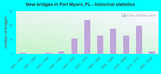
- New bridges - historical statistics
- 11920-1929
- 11940-1949
- 21950-1959
- 111960-1969
- 241970-1979
- 131980-1989
- 181990-1999
- 132000-2009
- 202010-2019
- 22020-2022

- Reconstructed bridges - Historical Statistics
- 21970-1979
- 11980-1989
- 11990-1999
- 102000-2009
- 42010-2019


- Bridge Condition - Deck
- 1.9%Excellent
- 16.7%Very good
- 72.2%Good
- 7.4%Satisfactory
- 1.9%Fair

- Bridge Condition - Superstructure
- 16.7%Very good
- 74.1%Good
- 5.6%Satisfactory
- 3.7%Fair

- Bridge Condition - Substructure
- 25.9%Very good
- 72.2%Good
- 1.9%Satisfactory

- Bridge Condition - Channel
- 1.8%Excellent
- 10.7%Very good
- 75.0%Good
- 10.7%Satisfactory
- 1.8%Fair

- Bridge Condition - Culverts
- 18.2%Very good
- 77.3%Good
- 4.5%Fair
Find on map >> Show street view
Structure Number: 120183, Location: 4.5MI WEST OF I-75 (Lat: 26.596836, Lng: -81.871733), Route carried "under" structure: US 41, Year Built: 1997, Structure Length: 0. m, Average Daily Traffic: 42,000 (year 2022), Truck Traffic: 4%, Features Intersected: US-41 (SR-45), Facility Carried by Structure: SR-884 (COLONIAL)
Minimum Vertical Clearance: 5.30m (17.39ft), Kilometerpoint: 33.008, Lanes on structure: 4, Lanes under structure: 8, Material/Design: Steel continuous, Design/Construction: Box Beam or Girders - Single/Spread, Length of Maximum Span: 77.1m (253.0ft)
Find on map >> Show street view
Structure Number: 120185, Location: 0.5 MI E of I-75 (SR-93) (Lat: 26.511806, Lng: -81.785472), Route carried "under" structure: County highway , Year Built: 2015, Structure Length: 0. m, Average Daily Traffic: 25,076 (year 2021), Truck Traffic: 5%, Features Intersected: BEN HILL GRIFFIN PRKY, Facility Carried by Structure: SWFIA TERMINAL ACC
Minimum Vertical Clearance: 5.24m (17.19ft), Kilometerpoint: 0.000, Lanes on structure: 4, Lanes under structure: 4, Material/Design: Prestressed concrete, Design/Construction: Stringer/Multi-beam, Length of Maximum Span: 51.2m (168.0ft)
Find on map >> Show street view
Structure Number: 12019, Location: 0.3 MI N/O US-41 (Lat: 26.495144, Lng: -81.843147), Route carried "under" structure: County highway , Year Built: 2012, Structure Length: 0. m, Average Daily Traffic: 22,500 (year 2020), Truck Traffic: 5%, Features Intersected: ALICO RD / SGRR, Facility Carried by Structure: MGRIPPEPKY NBSR739
Minimum Vertical Clearance: 5.97m (19.59ft), Kilometerpoint: 0.000, Lanes on structure: 2, Lanes under structure: 5, Material/Design: Prestressed concrete, Design/Construction: Stringer/Multi-beam, Length of Maximum Span: 47.2m (154.9ft)
Find on map >> Show street view
Structure Number: 120199, Location: 0.6 MI N/O WINKLER AVE (Lat: 26.612181, Lng: -81.855261), Route carried "under" structure: City street , Year Built: 2015, Structure Length: 0. m, Average Daily Traffic: 50 (year 2021), Features Intersected: PALM AVE & SGRR, Facility Carried by Structure: SR739 (METRO PKWY)
Minimum Vertical Clearance: 8.08m (26.51ft), Kilometerpoint: 0.000, Lanes on structure: 6, Lanes under structure: 2, Material/Design: Prestressed concrete, Design/Construction: Stringer/Multi-beam, Length of Maximum Span: 51.8m (169.9ft)
Find on map >> Show street view
Structure Number: 124095, Location: 1.1MI W OF US-41 (Lat: 26.596567, Lng: -81.890697), Route carried "under" structure: State highway 867, Year Built: 1997, Structure Length: 0. m, Average Daily Traffic: 60,020 (year 2021), Truck Traffic: 8%, Features Intersected: SR-867(MCGREGOR BLVD), Facility Carried by Structure: CR-884 (COLONIAL)
Minimum Vertical Clearance: 5.06m (16.60ft), Kilometerpoint: 0.000, Lanes on structure: 4, Lanes under structure: 4, Material/Design: Steel continuous, Design/Construction: Stringer/Multi-beam, Length of Maximum Span: 47.2m (154.9ft)
Find on map >> Show street view
Structure Number: 124111, Location: GLADIOLUS DR at SUMMERLIN (Lat: 26.520825, Lng: -81.891103), Route carried "under" structure: County highway 869, Year Built: 2007, Structure Length: 0. m, Average Daily Traffic: 4,789 (year 2022), Truck Traffic: 3%, Features Intersected: GLADIOLUS DR/SUMMERLIN R, Facility Carried by Structure: EB GLADIOLUS DR
Minimum Vertical Clearance: 5.18m (16.99ft), Kilometerpoint: 0.000, Lanes on structure: 1, Lanes under structure: 5, Material/Design: Steel continuous, Design/Construction: Stringer/Multi-beam, Length of Maximum Span: 70.9m (232.6ft)
Find on map >> Show street view
Structure Number: 124111, Location: GLADIOLUS DR at SUMMERLIN (Lat: 26.520825, Lng: -81.891103), Route carried "under" structure: County highway 865, Year Built: 2007, Structure Length: 0. m, Average Daily Traffic: 4,789 (year 2022), Truck Traffic: 3%, Features Intersected: GLADIOLUS DR/SUMMERLIN R, Facility Carried by Structure: EB GLADIOLUS DR
Minimum Vertical Clearance: 5.18m (16.99ft), Kilometerpoint: 0.000, Lanes on structure: 1, Lanes under structure: 5, Material/Design: Steel continuous, Design/Construction: Stringer/Multi-beam, Length of Maximum Span: 70.9m (232.6ft)
Find on map >> Show street view
Structure Number: 124112, Location: GLADIOLUS DR AT SUMMERLIN (Lat: 26.520625, Lng: -81.891017), Route carried "under" structure: County highway 865, Year Built: 2007, Structure Length: 0. m, Average Daily Traffic: 4,789 (year 2022), Truck Traffic: 3%, Features Intersected: GLADIOLUS DR/SUMMERLIN R, Facility Carried by Structure: WB GLADIOLUS DR
Minimum Vertical Clearance: 5.39m (17.68ft), Kilometerpoint: 0.000, Lanes on structure: 1, Lanes under structure: 5, Material/Design: Steel continuous, Design/Construction: Stringer/Multi-beam, Length of Maximum Span: 70.9m (232.6ft)
Find on map >> Show street view
Structure Number: 124112, Location: GLADIOLUS DR AT SUMMERLIN (Lat: 26.520625, Lng: -81.891017), Route carried "under" structure: County highway 869, Year Built: 2007, Structure Length: 0. m, Average Daily Traffic: 4,789 (year 2022), Truck Traffic: 3%, Features Intersected: GLADIOLUS DR/SUMMERLIN R, Facility Carried by Structure: WB GLADIOLUS DR
Minimum Vertical Clearance: 5.39m (17.68ft), Kilometerpoint: 0.000, Lanes on structure: 1, Lanes under structure: 5, Material/Design: Steel continuous, Design/Construction: Stringer/Multi-beam, Length of Maximum Span: 70.9m (232.6ft)
Find on map >> Show street view
Structure Number: 124113, Location: 0.8 MI N/O CYPRESS LK DR (Lat: 26.556933, Lng: -81.885322), Route carried "under" structure: County highway 869, Year Built: 2011, Structure Length: 0. m, Average Daily Traffic: 48,750 (year 2021), Truck Traffic: 3%, Features Intersected: COLLEGE PARKWAY
Minimum Vertical Clearance: 5.12m (16.80ft), Kilometerpoint: 0.000, Lanes on structure: 4, Lanes under structure: 6, Material/Design: Steel continuous, Design/Construction: Box Beam or Girders - Single/Spread, Length of Maximum Span: 66.3m (217.5ft)
Find on map >> Show street view
Structure Number: 124117, Location: 1.5 MI S/O GLADIOLUS DR (Lat: 26.493939, Lng: -81.943308), Route carried "under" structure: County highway 865, Year Built: 2007, Structure Length: 0. m, Average Daily Traffic: 22,640 (year 2021), Truck Traffic: 5%, Features Intersected: SAN CARLOS BLVD, Facility Carried by Structure: SUMMERLIN RD
Minimum Vertical Clearance: 5.12m (16.80ft), Kilometerpoint: 5.024, Lanes on structure: 4, Lanes under structure: 6, Material/Design: Steel, Design/Construction: Stringer/Multi-beam, Length of Maximum Span: 62.4m (204.7ft)
Find on map >> Show street view
Structure Number: 124128, Location: 1.2MI N/O CORKSCREW RD (Lat: 26.448739, Lng: -81.783811), Route carried "under" structure: Interstate 75, Year Built: 2009, Structure Length: 0. m, Average Daily Traffic: 81,500 (year 2021), Truck Traffic: 8%, Features Intersected: I-75, Facility Carried by Structure: ESTERO ROAD
Minimum Vertical Clearance: 6.40m (21.00ft), Kilometerpoint: 15.371, Lanes on structure: 4, Lanes under structure: 6, Material/Design: Steel continuous, Design/Construction: Box Beam or Girders - Single/Spread, Length of Maximum Span: 101.2m (332.0ft)