Bridge Statistics for Fort Pierce, Florida (FL)
Condition, Traffic, Stress, Structural Evaluation, Project Costs
- National Bridge Inventory (NBI) Statistics
- 61Number of bridges
- 1,181ft / 360mTotal length
- $422,000Total costs
- 1,078,937Total average daily traffic
- 157,048Total average daily truck traffic
- National Bridge Inventory (NBI) Registered Bridges for Fort Pierce
- No street view available for this location
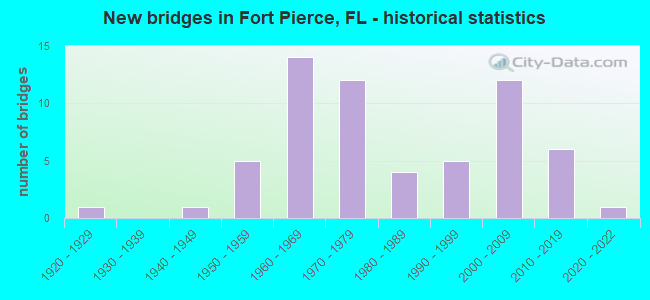
- New bridges - historical statistics
- 11920-1929
- 11940-1949
- 51950-1959
- 141960-1969
- 121970-1979
- 41980-1989
- 51990-1999
- 122000-2009
- 62010-2019
- 12020-2022

- Reconstructed bridges - Historical Statistics
- 31980-1989
- 21990-1999
- 62000-2009


- Bridge Condition - Deck
- 5.7%Excellent
- 17.1%Very good
- 51.4%Good
- 14.3%Satisfactory
- 2.9%Fair
- 8.6%Poor

- Bridge Condition - Superstructure
- 8.3%Excellent
- 25.0%Very good
- 47.2%Good
- 8.3%Satisfactory
- 5.6%Fair
- 5.6%Poor

- Bridge Condition - Substructure
- 5.6%Excellent
- 36.1%Very good
- 41.7%Good
- 16.7%Satisfactory

- Bridge Condition - Channel
- 3.3%Excellent
- 33.3%Very good
- 50.0%Good
- 6.7%Satisfactory
- 6.7%Fair

- Bridge Condition - Culverts
- 44.4%Very good
- 55.6%Good
Find on map >> Show street view
Structure Number: 945013, Location: 0.3 Mi N of Orange Ave. (Lat: 27.451503, Lng: -80.330650), Route carried "on" structure: City street , Year Built: 2009, Status: Open, Structure Length: 0.84m (2.76ft), Average Daily Traffic: 120 (year 2021), Truck Traffic: 1%, Average Future Daily Traffic: 144 (year 2042), Design Load: HS 20, Features Intersected: Moores Creek, Facility Carried by Structure: 8th Street N
Minimum Vertical Clearance: 30+ m (98+ ft), Kilometerpoint: 0.000, Lanes on structure: 2, Owner: City or Municipal Highway Agency, Approaching Roadway Width: 9.6m (31.5ft), Material/Design: Concrete, Design/Construction: Culvert, Number Of Spans In Main Unit: 1, Length of Maximum Span: 8.4m (27.6ft), Curb or Sidewalk Widths: Left: 2.0m (6.6ft), Right: 3.1m (10.2ft)
Condition: Channel: Good, Culverts: Very good, Operating Rating: 61.8 metric tons, Method Used To Determine Operating Rating: Load Factor (LF), Inventory Rating: 41.3 metric tons, Method Used To Determine Inventory Rating: Load Factor (LF), Structural Evaluation: Equal to present desirable criteria, Waterway Adequacy: Equal to present desirable criteria, Approach Roadway Alignment: Equal to present desirable criteria, Designated Inspection Frequency: Every 24 months, Inspection Date: July 2021
Find on map >> Show street view
Structure Number: 945014, Location: 0.3 Miles North of CR-68 (Lat: 27.451389, Lng: -80.331722), Route carried "on" structure: City street , Year Built: 2009, Status: Open, Structure Length: 0.85m (2.79ft), Average Daily Traffic: 1,500 (year 2022), Truck Traffic: 2%, Average Future Daily Traffic: 2,603 (year 2042), Design Load: HL 93, Features Intersected: Moore's Creek, Facility Carried by Structure: North 9th Street
Minimum Vertical Clearance: 30+ m (98+ ft), Kilometerpoint: 0.000, Lanes on structure: 2, Owner: City or Municipal Highway Agency, Approaching Roadway Width: 9.3m (30.5ft), Material/Design: Concrete, Design/Construction: Culvert, Number Of Spans In Main Unit: 1, Length of Maximum Span: 8.5m (27.9ft)
Condition: Channel: Good, Culverts: Very good, Operating Rating: 48.5 metric tons, Method Used To Determine Operating Rating: Load and Resistance Factor (LRFR), Inventory Rating: 39.0 metric tons, Method Used To Determine Inventory Rating: Load and Resistance Factor (LRFR), Structural Evaluation: Equal to present desirable criteria, Approach Roadway Alignment: Equal to present desirable criteria, Designated Inspection Frequency: Every 24 months, Inspection Date: Febuary 2022
Find on map >> Show street view
Structure Number: 945015, Location: 0.1 Miles S. of Ave. D (Lat: 27.451389, Lng: -80.332444), Route carried "on" structure: City street , Year Built: 2009, Status: Open, Structure Length: 0.85m (2.79ft), Average Daily Traffic: 500 (year 2022), Truck Traffic: 2%, Average Future Daily Traffic: 521 (year 2042), Design Load: HL 93, Features Intersected: Moore's Creek, Facility Carried by Structure: Dundas Court
Minimum Vertical Clearance: 30+ m (98+ ft), Kilometerpoint: 0.000, Lanes on structure: 2, Owner: City or Municipal Highway Agency, Approaching Roadway Width: 7.5m (24.6ft), Material/Design: Concrete, Design/Construction: Culvert, Number Of Spans In Main Unit: 1, Length of Maximum Span: 8.5m (27.9ft)
Condition: Channel: Good, Culverts: Very good, Operating Rating: 48.5 metric tons, Method Used To Determine Operating Rating: Load and Resistance Factor (LRFR), Inventory Rating: 39.0 metric tons, Method Used To Determine Inventory Rating: Load and Resistance Factor (LRFR), Structural Evaluation: Equal to present desirable criteria, Approach Roadway Alignment: Equal to present desirable criteria, Designated Inspection Frequency: Every 24 months, Inspection Date: Febuary 2022
Find on map >> Show street view
Structure Number: 945016, Location: 0.26 Miles North of CR-68 (Lat: 27.450944, Lng: -80.338306), Route carried "on" structure: City street , Year Built: 2009, Status: Open, Structure Length: 0.88m (2.89ft), Average Daily Traffic: 1,400 (year 2022), Truck Traffic: 2%, Average Future Daily Traffic: 2,256 (year 2042), Design Load: HL 93, Features Intersected: Moore's Creek, Facility Carried by Structure: North 14th Street
Minimum Vertical Clearance: 30+ m (98+ ft), Kilometerpoint: 0.000, Lanes on structure: 2, Owner: City or Municipal Highway Agency, Approaching Roadway Width: 7.5m (24.6ft), Material/Design: Concrete, Design/Construction: Culvert, Number Of Spans In Main Unit: 1, Length of Maximum Span: 8.8m (28.9ft), Curb-To-Curb Width: 7.5m (24.6ft), Out-to-Out Width: 14.3m (46.9ft)
Condition: Channel: Good, Culverts: Very good, Operating Rating: 48.5 metric tons, Method Used To Determine Operating Rating: Load and Resistance Factor (LRFR), Inventory Rating: 39.0 metric tons, Method Used To Determine Inventory Rating: Load and Resistance Factor (LRFR), Structural Evaluation: Equal to present desirable criteria, Deck Geometry: Meets minimum limits, Approach Roadway Alignment: Equal to present desirable criteria, Designated Inspection Frequency: Every 24 months, Inspection Date: Febuary 2022
Find on map >> Show street view
Structure Number: 940053, Location: FT PIERCE INTERCHANGE (Lat: 27.408350, Lng: -80.400331), Route carried "under" structure: State highway 91, Year Built: 1956, Structure Length: 0. m, Average Daily Traffic: 37,600 (year 2021), Truck Traffic: 19%, Features Intersected: SR 91 TPK(FT PIERCE INT)
Minimum Vertical Clearance: 5.03m (16.50ft), Kilometerpoint: 23.723, Lanes on structure: 2, Lanes under structure: 5, Toll: On toll road, Material/Design: Prestressed concrete, Design/Construction: Stringer/Multi-beam, Length of Maximum Span: 17.7m (58.1ft)
Find on map >> Show street view
Structure Number: 940055, Location: 1.16 MI S OF CR-68 (Lat: 27.433019, Lng: -80.418472), Route carried "under" structure: State highway 91, Year Built: 1964, Structure Length: 0. m, Average Daily Traffic: 28,700 (year 2022), Truck Traffic: 12%, Features Intersected: SR 91 TPK, Facility Carried by Structure: PICOS RD 154.90
Minimum Vertical Clearance: 4.88m (16.01ft), Kilometerpoint: 27.006, Lanes on structure: 2, Lanes under structure: 4, Toll: On toll road, Material/Design: Prestressed concrete, Design/Construction: Stringer/Multi-beam, Length of Maximum Span: 21.3m (69.9ft)
Find on map >> Show street view
Structure Number: 940056, Location: 2.9 MI N OF SR-70 (Lat: 27.447558, Lng: -80.427328), Route carried "under" structure: State highway 91, Year Built: 1964, Structure Length: 0. m, Average Daily Traffic: 28,700 (year 2022), Truck Traffic: 12%, Features Intersected: SR 91 TPK, Facility Carried by Structure: CR68 ORNG AV 156.1
Minimum Vertical Clearance: 5.09m (16.70ft), Kilometerpoint: 28.864, Lanes on structure: 2, Lanes under structure: 4, Toll: On toll road, Material/Design: Prestressed concrete, Design/Construction: Stringer/Multi-beam, Length of Maximum Span: 17.7m (58.1ft)
Find on map >> Show street view
Structure Number: 940057, Location: 1.83 MILES N OF CR-68 (Lat: 27.470219, Lng: -80.443253), Route carried "under" structure: County highway , Year Built: 1964, Structure Length: 0. m, Average Daily Traffic: 14,350 (year 2022), Truck Traffic: 12%, Features Intersected: ANGLE RD & BELCHER CANAL, Facility Carried by Structure: SR91 SB TPK 157.9
Minimum Vertical Clearance: 5.03m (16.50ft), Kilometerpoint: 31.879, Lanes on structure: 2, Lanes under structure: 2, Material/Design: Prestressed concrete, Design/Construction: Stringer/Multi-beam, Length of Maximum Span: 20.4m (66.9ft)
Find on map >> Show street view
Structure Number: 940073, Location: 1.83 MILES N OF CR-68 (Lat: 27.470278, Lng: -80.443044), Route carried "under" structure: County highway , Year Built: 1964, Structure Length: 0. m, Average Daily Traffic: 14,350 (year 2022), Truck Traffic: 12%, Features Intersected: ANGLE RD & BELCHER CANAL, Facility Carried by Structure: SR91 NB TPK 157.9
Minimum Vertical Clearance: 5.03m (16.50ft), Kilometerpoint: 31.849, Lanes on structure: 2, Lanes under structure: 2, Material/Design: Prestressed concrete, Design/Construction: Stringer/Multi-beam, Length of Maximum Span: 20.1m (65.9ft)
Find on map >> Show street view
Structure Number: 940096, Location: 6.5 Mi S of SR-614 (Lat: 27.447517, Lng: -80.394194), Route carried "under" structure: State highway 68, Year Built: 1977, Structure Length: 0. m, Average Daily Traffic: 19,800 (year 2020), Truck Traffic: 23%, Features Intersected: SR-68, Facility Carried by Structure: SB I-95 (S.R. 9)
Minimum Vertical Clearance: 4.86m (15.94ft), Kilometerpoint: 0.451, Lanes on structure: 5, Lanes under structure: 8, Material/Design: Steel, Design/Construction: Stringer/Multi-beam, Length of Maximum Span: 41.2m (135.2ft)
Find on map >> Show street view
Structure Number: 940097, Location: 2.2 Mi. N of SR70 (Lat: 27.447506, Lng: -80.393794), Route carried "under" structure: State highway 68, Year Built: 1977, Structure Length: 0. m, Average Daily Traffic: 19,800 (year 2020), Truck Traffic: 23%, Features Intersected: SR-68, Facility Carried by Structure: NB I-95 (S.R. 9)
Minimum Vertical Clearance: 4.80m (15.75ft), Kilometerpoint: 0.515, Lanes on structure: 5, Lanes under structure: 8, Material/Design: Steel, Design/Construction: Stringer/Multi-beam, Length of Maximum Span: 41.2m (135.2ft)
Find on map >> Show street view
Structure Number: 9401, Location: 1mi. N of SR-70/SR-9 (Lat: 27.429208, Lng: -80.388375), Route carried "under" structure: Interstate 95, Year Built: 1977, Structure Length: 0. m, Average Daily Traffic: 60,386 (year 2020), Truck Traffic: 17%, Features Intersected: SR-9 (I-95), Facility Carried by Structure: Graham Road
Minimum Vertical Clearance: 4.91m (16.11ft), Kilometerpoint: 26.281, Lanes on structure: 2, Lanes under structure: 8, Material/Design: Prestressed concrete, Design/Construction: Stringer/Multi-beam, Length of Maximum Span: 30.5m (100.1ft)
Find on map >> Show street view
Structure Number: 940101, Location: 2MI S of SR-68(Orange Av) (Lat: 27.415917, Lng: -80.388531), Route carried "under" structure: State highway 70, Year Built: 1977, Structure Length: 0. m, Average Daily Traffic: 26,500 (year 2020), Truck Traffic: 10%, Features Intersected: SR-70 (Okeechobee Rd.), Facility Carried by Structure: SB SR-9 ( I-95)
Minimum Vertical Clearance: 5.15m (16.90ft), Kilometerpoint: 34.108, Lanes on structure: 4, Lanes under structure: 8, Material/Design: Prestressed concrete, Design/Construction: Stringer/Multi-beam, Length of Maximum Span: 24.6m (80.7ft)
Find on map >> Show street view
Structure Number: 940102, Location: 2MI S of SR-68(Orange Av) (Lat: 27.416000, Lng: -80.388286), Route carried "under" structure: State highway 70, Year Built: 1977, Structure Length: 0. m, Average Daily Traffic: 32,000 (year 2020), Truck Traffic: 12%, Features Intersected: SR-70 (Okeechobee Rd.), Facility Carried by Structure: NB SR-9 (I-95)
Minimum Vertical Clearance: 4.97m (16.31ft), Kilometerpoint: 34.149, Lanes on structure: 6, Lanes under structure: 8, Material/Design: Prestressed concrete, Design/Construction: Stringer/Multi-beam, Length of Maximum Span: 24.6m (80.7ft)
Find on map >> Show street view
Structure Number: 940126, Location: 1.5 Mi. S of SR-70 (Lat: 27.395767, Lng: -80.394456), Route carried "under" structure: State highway 91, Year Built: 1982, Structure Length: 0. m, Average Daily Traffic: 37,600 (year 2020), Truck Traffic: 19%, Features Intersected: SR-91 (FL TPK), Facility Carried by Structure: SB I-95 (SR-9)
Minimum Vertical Clearance: 4.96m (16.27ft), Kilometerpoint: 22.209, Lanes on structure: 3, Lanes under structure: 4, Toll: On toll road, Material/Design: Prestressed concrete, Design/Construction: Stringer/Multi-beam, Length of Maximum Span: 31.7m (104.0ft)
Find on map >> Show street view
Structure Number: 940127, Location: 1.5 Mi. S of SR-70 (Lat: 27.395425, Lng: -80.394289), Route carried "under" structure: State highway 91, Year Built: 1982, Structure Length: 0. m, Average Daily Traffic: 37,600 (year 2020), Truck Traffic: 19%, Features Intersected: SR-91 (FL TPK), Facility Carried by Structure: NB I-95 (SR-9)
Minimum Vertical Clearance: 4.94m (16.21ft), Kilometerpoint: 22.167, Lanes on structure: 3, Lanes under structure: 4, Toll: On toll road, Material/Design: Prestressed concrete, Design/Construction: Stringer/Multi-beam, Length of Maximum Span: 31.7m (104.0ft)
Find on map >> Show street view
Structure Number: 940134, Location: 2.6 MILES NORTH OF SR-709 (Lat: 27.412358, Lng: -80.402019), Route carried "under" structure: State highway 70, Year Built: 1991, Structure Length: 0. m, Average Daily Traffic: 8,600 (year 2021), Truck Traffic: 20%, Features Intersected: SR 70, Facility Carried by Structure: SR 91 TPK SB 153.2
Minimum Vertical Clearance: 5.21m (17.09ft), Kilometerpoint: 32.716, Lanes on structure: 3, Lanes under structure: 5, Material/Design: Prestressed concrete, Design/Construction: Stringer/Multi-beam, Length of Maximum Span: 36.0m (118.1ft)
Find on map >> Show street view
Structure Number: 940135, Location: 2.6 MILES NORTH OF SR-709 (Lat: 27.412386, Lng: -80.401839), Route carried "under" structure: State highway 70, Year Built: 1991, Structure Length: 0. m, Average Daily Traffic: 18,800 (year 2021), Truck Traffic: 19%, Features Intersected: SR 70, Facility Carried by Structure: SR91 NB TPK 153.1
Minimum Vertical Clearance: 5.21m (17.09ft), Kilometerpoint: 24.190, Lanes on structure: 3, Lanes under structure: 5, Toll: On toll road, Material/Design: Prestressed concrete, Design/Construction: Stringer/Multi-beam, Length of Maximum Span: 36.0m (118.1ft)
Find on map >> Show street view
Structure Number: 940162, Location: 0.6 mi N of CR-68 (Lat: 27.455006, Lng: -80.398992), Route carried "under" structure: State highway 713, Year Built: 2013, Structure Length: 0. m, Average Daily Traffic: 14,100 (year 2020), Truck Traffic: 24%, Features Intersected: SR-713 (King Hwy), Facility Carried by Structure: SB SR-9 (I-95)
Minimum Vertical Clearance: 5.11m (16.77ft), Kilometerpoint: 4.643, Lanes on structure: 4, Lanes under structure: 2, Material/Design: Prestressed concrete, Design/Construction: Stringer/Multi-beam, Length of Maximum Span: 28.5m (93.5ft)
Find on map >> Show street view
Structure Number: 940163, Location: 0.6 mi N of CR-68 (Lat: 27.454736, Lng: -80.398997), Route carried "under" structure: State highway 713, Year Built: 2013, Structure Length: 0. m, Average Daily Traffic: 14,100 (year 2020), Truck Traffic: 24%, Features Intersected: SR-713 (King Hwy), Facility Carried by Structure: NB SR-9 (I-95)
Minimum Vertical Clearance: 5.11m (16.77ft), Kilometerpoint: 4.643, Lanes on structure: 4, Lanes under structure: 2, Material/Design: Prestressed concrete, Design/Construction: Stringer/Multi-beam, Length of Maximum Span: 28.5m (93.5ft)