Bridge Statistics for Fresno, California (CA)
Condition, Traffic, Stress, Structural Evaluation, Project Costs
- National Bridge Inventory (NBI) Statistics
- 551Number of bridges
- 7,218ft / 2,200mTotal length
- $14,141,000Total costs
- 16,572,698Total average daily traffic
- 1,423,123Total average daily truck traffic
- National Bridge Inventory (NBI) Registered Bridges for Fresno
- No street view available for this location
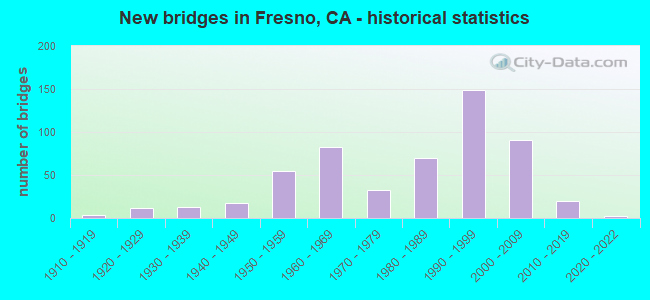
- New bridges - historical statistics
- 11900-1909
- 41910-1919
- 121920-1929
- 131930-1939
- 181940-1949
- 551950-1959
- 831960-1969
- 331970-1979
- 701980-1989
- 1491990-1999
- 912000-2009
- 202010-2019
- 22020-2022
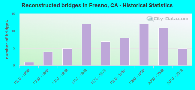
- Reconstructed bridges - Historical Statistics
- 11930-1939
- 41940-1949
- 51950-1959
- 121960-1969
- 71970-1979
- 81980-1989
- 121990-1999
- 112000-2009
- 52010-2019
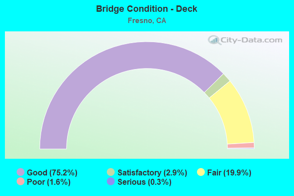
- Bridge Condition - Deck
- 75.2%Good
- 2.9%Satisfactory
- 19.9%Fair
- 1.6%Poor
- 0.3%Serious
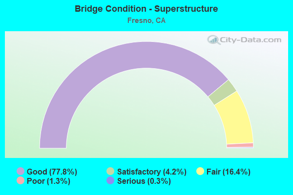
- Bridge Condition - Superstructure
- 77.8%Good
- 4.2%Satisfactory
- 16.4%Fair
- 1.3%Poor
- 0.3%Serious
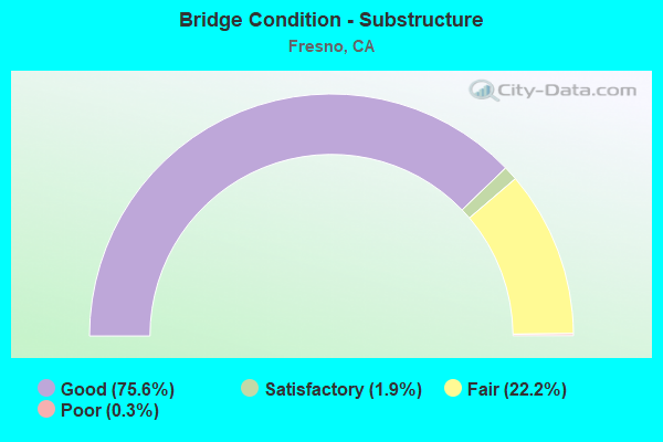
- Bridge Condition - Substructure
- 75.6%Good
- 1.9%Satisfactory
- 22.2%Fair
- 0.3%Poor
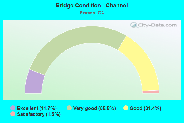
- Bridge Condition - Channel
- 11.7%Excellent
- 55.5%Very good
- 31.4%Good
- 1.5%Satisfactory
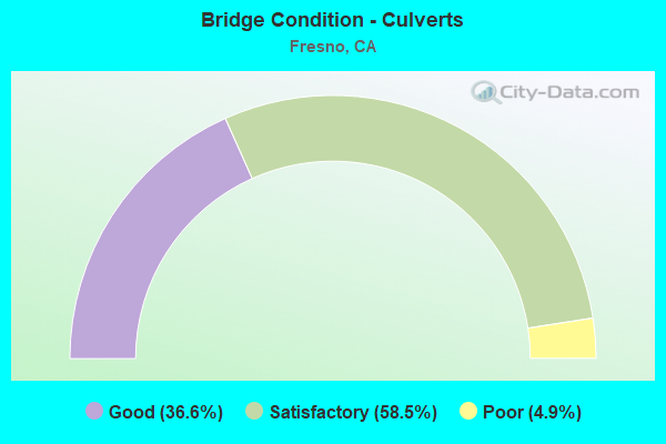
- Bridge Condition - Culverts
- 36.6%Good
- 58.5%Satisfactory
- 4.9%Poor
Find on map >> Show street view
Structure Number: 42C0122, Location: 0.1 MI WEST OF MILLBROOK (Lat: 36.779467, Lng: -119.766228), Route carried "on" structure: City street , Year Built: 1962, Status: Open, Structure Length: 1.01m (3.31ft), Average Daily Traffic: 27,039 (year 2004), Truck Traffic: 2%, Average Future Daily Traffic: 27,897 (year 2042), Features Intersected: DRY CREEK CANAL, Facility Carried by Structure: E SHIELDS AVE
Minimum Vertical Clearance: 30+ m (98+ ft), Kilometerpoint: 0.000, Lanes on structure: 4, Base Highway Network: Yes, Owner: City or Municipal Highway Agency, Approaching Roadway Width: 17.7m (58.1ft), Skew: 24 degrees, Material/Design: Concrete continuous, Design/Construction: Culvert, Number Of Spans In Main Unit: 2, Length of Maximum Span: 4.9m (16.1ft), Curb or Sidewalk Widths: Left: 1.5m (4.9ft), Right: 1.5m (4.9ft), Curb-To-Curb Width: 17.7m (58.1ft), Out-to-Out Width: 26.2m (86.0ft)
Condition: Channel: Very good, Culverts: Poor, Operating Rating: 40.5 metric tons, Method Used To Determine Operating Rating: Field evaluation and documented engineering judgment, Inventory Rating: 24.3 metric tons, Method Used To Determine Inventory Rating: Field evaluation and documented engineering judgment, Structural Evaluation: Meets minimum limits, Deck Geometry: Somewhat better than minimum adequacy, Waterway Adequacy: Equal to present desirable criteria, Approach Roadway Alignment: Equal to present desirable criteria, Length Of Structure Improvement: 1.01m (3.31ft), Designated Inspection Frequency: Every 24 months, Inspection Date: December 2020, Bridge Improvement Cost: $607,000, Roadway Improvement Cost: $121,000, Total Project Cost: $1,020,000 ( Estimate for 2018), Deck Structure Type: Concrete Cast-file-Place, Wearing Surface/Protective System: Wearing Surface: Bituminous
Find on map >> Show street view
Structure Number: 42C013, Location: EAST OF BROADWAY (Lat: 36.750308, Lng: -119.801547), Route carried "on" structure: City street , Year Built: 1989, Status: Open, Structure Length: 1.31m (4.30ft), Average Daily Traffic: 15,700 (year 2009), Truck Traffic: 7%, Average Future Daily Traffic: 26,810 (year 2041), Design Load: HS 20, Features Intersected: DRY CREEK CANAL, Facility Carried by Structure: E BELMONT AVE
Minimum Vertical Clearance: 30+ m (98+ ft), Kilometerpoint: 0.000, Lanes on structure: 4, Owner: City or Municipal Highway Agency, Approaching Roadway Width: 15.8m (51.8ft), Skew: 1 degrees, Material/Design: Concrete continuous, Design/Construction: Slab, Number Of Spans In Main Unit: 2, Length of Maximum Span: 6.4m (21.0ft), Curb or Sidewalk Widths: Left: 2.1m (6.9ft), Right: 2.1m (6.9ft), Curb-To-Curb Width: 19.5m (64.0ft), Out-to-Out Width: 24.3m (79.7ft)
Condition: Deck: Good, Superstructure: Good, Substructure: Good, Channel: Very good, Operating Rating: 54.1 metric tons, Method Used To Determine Operating Rating: Assigned rating based on Load Factor Design (LFD) reported in metric tons, Inventory Rating: 32.4 metric tons, Method Used To Determine Inventory Rating: Assigned rating based on Load Factor Design (LFD) reported in metric tons, Structural Evaluation: Better than present minimum criteria, Deck Geometry: Better than present minimum criteria, Waterway Adequacy: Equal to present desirable criteria, Approach Roadway Alignment: Equal to present desirable criteria, Designated Inspection Frequency: Every 48 months, Inspection Date: January 2021, Deck Structure Type: Concrete Cast-file-Place
Find on map >> Show street view
Structure Number: 42C0136, Location: 900 FT E OF GOLDEN ST BLV (Lat: 36.706808, Lng: -119.766644), Route carried "on" structure: City street , Year Built: 1963, Status: Open, Structure Length: 20.03m (65.72ft), Average Daily Traffic: 32,029 (year 2006), Truck Traffic: 5%, Average Future Daily Traffic: 47,185 (year 2041), Design Load: HS 20, Features Intersected: UP RR, BNSF,AMTRAK, & ST, Facility Carried by Structure: E JENSEN AVE
Minimum Vertical Clearance: 30+ m (98+ ft), Kilometerpoint: 0.000, Lanes on structure: 4, Lanes under structure: 4, Base Highway Network: Yes, Owner: City or Municipal Highway Agency, Approaching Roadway Width: 19.5m (64.0ft), Skew: 34 degrees, Material/Design: Prestressed concrete, Design/Construction: Stringer/Multi-beam, Number Of Spans In Main Unit: 6, Length of Maximum Span: 33.8m (110.9ft), Curb or Sidewalk Widths: Left: 1.6m (5.2ft), Right: 1.6m (5.2ft), Curb-To-Curb Width: 18.3m (60.0ft), Out-to-Out Width: 23.8m (78.1ft)
Condition: Deck: Good, Superstructure: Good, Substructure: Good, Operating Rating: 48.0 metric tons, Method Used To Determine Operating Rating: Load and Resistance Factor Rating (LRFR) rating reported by rating factor(RF) method using HL-93 loadings, Inventory Rating: 31.4 metric tons, Method Used To Determine Inventory Rating: Load and Resistance Factor Rating (LRFR) rating reported by rating factor(RF) method using HL-93 loadings, Structural Evaluation: Better than present minimum criteria, Deck Geometry: Somewhat better than minimum adequacy, Underclear: Meets minimum limits, Approach Roadway Alignment: Equal to present desirable criteria, Designated Inspection Frequency: Every 24 months, Inspection Date: January 2021, Deck Structure Type: Concrete Cast-file-Place
Find on map >> Show street view
Structure Number: 42C016, Location: 0.7 MI E OF S MARKS AVE (Lat: 36.430969, Lng: -119.838200), Route carried "on" structure: County highway , Year Built: 1925, Year Reconstructed: 1985, Status: Open, Structure Length: 1.13m (3.71ft), Average Daily Traffic: 5,600 (year 2004), Truck Traffic: 2%, Average Future Daily Traffic: 9,440 (year 2040), Features Intersected: BURREL DITCH, Facility Carried by Structure: W MT WHITNEY AVE
Minimum Vertical Clearance: 30+ m (98+ ft), Kilometerpoint: 0.000, Lanes on structure: 2, Owner: County Highway Agency, Approaching Roadway Width: 9.8m (32.2ft), Skew: 4 degrees, Material/Design: Concrete continuous, Design/Construction: Slab, Number Of Spans In Main Unit: 2, Length of Maximum Span: 5.5m (18.0ft), Curb-To-Curb Width: 18.3m (60.0ft), Out-to-Out Width: 19.1m (62.7ft)
Condition: Deck: Good, Superstructure: Good, Substructure: Good, Channel: Good, Operating Rating: 59.3 metric tons, Method Used To Determine Operating Rating: Load Factor (LF), Inventory Rating: 35.6 metric tons, Method Used To Determine Inventory Rating: Load Factor (LF), Structural Evaluation: Better than present minimum criteria, Deck Geometry: Superior to present desirable criteria, Waterway Adequacy: Better than present minimum criteria, Approach Roadway Alignment: Equal to present desirable criteria, Designated Inspection Frequency: Every 48 months, Inspection Date: Febuary 2020, Deck Structure Type: Concrete Cast-file-Place, Wearing Surface/Protective System: Wearing Surface: Bituminous
Find on map >> Show street view
Structure Number: 42C0165, Location: AT S MARKS AVE (Lat: 36.721128, Lng: -119.844617), Route carried "on" structure: City street , Year Built: 1960, Year Reconstructed: 2006, Status: Open, Structure Length: 0.67m (2.20ft), Average Daily Traffic: 2,100 (year 2009), Truck Traffic: 5%, Average Future Daily Traffic: 7,753 (year 2041), Features Intersected: DRY CREEK CANAL, Facility Carried by Structure: W CALIFORNIA AVE
Minimum Vertical Clearance: 30+ m (98+ ft), Kilometerpoint: 0.000, Lanes on structure: 2, Owner: City or Municipal Highway Agency, Approaching Roadway Width: 9.8m (32.2ft), Skew: 4 degrees, Material/Design: Concrete continuous, Design/Construction: Culvert, Number Of Spans In Main Unit: 2, Length of Maximum Span: 3.4m (11.2ft), Curb-To-Curb Width: 64.3m (211.0ft), Out-to-Out Width: 64.9m (212.9ft)
Condition: Channel: Good, Culverts: Satisfactory, Operating Rating: 40.5 metric tons, Method Used To Determine Operating Rating: Field evaluation and documented engineering judgment, Inventory Rating: 24.3 metric tons, Method Used To Determine Inventory Rating: Field evaluation and documented engineering judgment, Structural Evaluation: Equal to present minimum criteria, Deck Geometry: Superior to present desirable criteria, Waterway Adequacy: Equal to present desirable criteria, Approach Roadway Alignment: Equal to present desirable criteria, Designated Inspection Frequency: Every 24 months, Inspection Date: January 2021, Deck Structure Type: Concrete Cast-file-Place, Wearing Surface/Protective System: Wearing Surface: Bituminous
Find on map >> Show street view
Structure Number: 42C0172L, Location: 1.0 MI NORTH OF WILLOW AV (Lat: 36.934450, Lng: -119.730103), Route carried "on" structure: County highway , Year Built: 1973, Status: Open, Structure Length: 4.97m (16.31ft), Average Daily Traffic: 9,200 (year 2012), Truck Traffic: 5%, Average Future Daily Traffic: 4,313 (year 2040), Features Intersected: LITTLE DRY CREEK, Facility Carried by Structure: N FRIANT ROAD SB
Minimum Vertical Clearance: 30+ m (98+ ft), Kilometerpoint: 0.000, Lanes on structure: 2, Owner: County Highway Agency, Approaching Roadway Width: 11.0m (36.1ft), Material/Design: Concrete continuous, Design/Construction: Slab, Number Of Spans In Main Unit: 7, Length of Maximum Span: 7.6m (24.9ft), Curb-To-Curb Width: 11.5m (37.7ft), Out-to-Out Width: 12.4m (40.7ft)
Condition: Deck: Good, Superstructure: Good, Substructure: Fair, Channel: Good, Operating Rating: 95.9 metric tons, Method Used To Determine Operating Rating: Load Factor (LF), Inventory Rating: 57.7 metric tons, Method Used To Determine Inventory Rating: Load Factor (LF), Structural Evaluation: Somewhat better than minimum adequacy, Deck Geometry: Equal to present minimum criteria, Waterway Adequacy: Equal to present minimum criteria, Approach Roadway Alignment: Equal to present desirable criteria, Designated Inspection Frequency: Every 24 months, Inspection Date: January 2021, Deck Structure Type: Concrete Cast-file-Place, Wearing Surface/Protective System: Wearing Surface: Bituminous
Find on map >> Show street view
Structure Number: 42C0172R, Location: 1.0 MI NORTH OF WILLOW AV (Lat: 36.934244, Lng: -119.730044), Route carried "on" structure: County highway , Year Built: 2007, Status: Open, Structure Length: 4.92m (16.14ft), Average Daily Traffic: 9,200 (year 2012), Truck Traffic: 5%, Average Future Daily Traffic: 4,285 (year 2039), Design Load: HS 20+Mod, Features Intersected: LITTLE DRY CREEK, Facility Carried by Structure: N FRIANT ROAD NB
Minimum Vertical Clearance: 30+ m (98+ ft), Kilometerpoint: 0.000, Lanes on structure: 2, Owner: County Highway Agency, Approaching Roadway Width: 11.0m (36.1ft), Material/Design: Concrete continuous, Design/Construction: Slab, Number Of Spans In Main Unit: 7, Length of Maximum Span: 7.6m (24.9ft), Curb-To-Curb Width: 11.0m (36.1ft), Out-to-Out Width: 11.2m (36.7ft)
Condition: Deck: Good, Superstructure: Good, Substructure: Good, Channel: Very good, Operating Rating: 54.1 metric tons, Method Used To Determine Operating Rating: Assigned rating based on Load Factor Design (LFD) reported in metric tons, Inventory Rating: 32.4 metric tons, Method Used To Determine Inventory Rating: Assigned rating based on Load Factor Design (LFD) reported in metric tons, Structural Evaluation: Better than present minimum criteria, Deck Geometry: Equal to present minimum criteria, Waterway Adequacy: Equal to present desirable criteria, Approach Roadway Alignment: Equal to present desirable criteria, Designated Inspection Frequency: Every 48 months, Inspection Date: January 2019, Deck Structure Type: Concrete Cast-file-Place
Find on map >> Show street view
Structure Number: 42C018, Location: 0.75 MI SOUTH OF SR 180 (Lat: 36.708831, Lng: -119.394622), Route carried "on" structure: County highway , Year Built: 1956, Status: Open, Structure Length: 3.66m (12.01ft), Average Daily Traffic: 225 (year 2010), Truck Traffic: 10%, Average Future Daily Traffic: 270 (year 2040), Features Intersected: FRIANT-KERN CANAL, Facility Carried by Structure: S ALTA AVE
Minimum Vertical Clearance: 30+ m (98+ ft), Kilometerpoint: 0.000, Lanes on structure: 2, Owner: County Highway Agency, Approaching Roadway Width: 7.3m (24.0ft), Material/Design: Concrete continuous, Design/Construction: Tee Beam, Number Of Spans In Main Unit: 3, Length of Maximum Span: 13.0m (42.7ft), Curb or Sidewalk Widths: Left: 0.3m (1.0ft), Right: 0.3m (1.0ft), Curb-To-Curb Width: 7.3m (24.0ft), Out-to-Out Width: 8.8m (28.9ft)
Condition: Deck: Good, Superstructure: Good, Substructure: Fair, Channel: Good, Operating Rating: 30.1 metric tons, Method Used To Determine Operating Rating: Field evaluation and documented engineering judgment, Inventory Rating: 18.1 metric tons, Method Used To Determine Inventory Rating: Field evaluation and documented engineering judgment, Structural Evaluation: Somewhat better than minimum adequacy, Deck Geometry: Somewhat better than minimum adequacy, Waterway Adequacy: Superior to present desirable criteria, Approach Roadway Alignment: Equal to present desirable criteria, Designated Inspection Frequency: Every 24 months, Inspection Date: December 2020, Deck Structure Type: Concrete Cast-file-Place
Find on map >> Show street view
Structure Number: 42C0188, Location: AT MILLBROOK AVE (Lat: 36.764908, Lng: -119.763814), Route carried "on" structure: City street , Year Built: 1964, Year Reconstructed: 1984, Status: Open, Structure Length: 1.01m (3.31ft), Average Daily Traffic: 20,398 (year 2007), Truck Traffic: 4%, Average Future Daily Traffic: 43,614 (year 2041), Features Intersected: HERNDON CANAL, Facility Carried by Structure: E MCKINLEY AVE
Minimum Vertical Clearance: 30+ m (98+ ft), Kilometerpoint: 0.000, Lanes on structure: 5, Base Highway Network: Yes, Owner: City or Municipal Highway Agency, Approaching Roadway Width: 19.5m (64.0ft), Skew: 20 degrees, Material/Design: Concrete continuous, Design/Construction: Culvert, Number Of Spans In Main Unit: 3, Length of Maximum Span: 3.4m (11.2ft), Curb or Sidewalk Widths: Left: 1.5m (4.9ft), Right: 1.5m (4.9ft), Curb-To-Curb Width: 19.5m (64.0ft), Out-to-Out Width: 25.8m (84.6ft)
Condition: Channel: Very good, Culverts: Satisfactory, Operating Rating: 40.5 metric tons, Method Used To Determine Operating Rating: Field evaluation and documented engineering judgment, Inventory Rating: 24.3 metric tons, Method Used To Determine Inventory Rating: Field evaluation and documented engineering judgment, Structural Evaluation: Equal to present minimum criteria, Deck Geometry: Meets minimum limits, Waterway Adequacy: Equal to present desirable criteria, Approach Roadway Alignment: Equal to present desirable criteria, Designated Inspection Frequency: Every 24 months, Inspection Date: January 2021, Deck Structure Type: Concrete Cast-file-Place
Find on map >> Show street view
Structure Number: 42C0189, Location: NEAR E. OLIVE AVE (Lat: 36.757456, Lng: -119.790431), Route carried "on" structure: Business City street , Year Built: 1941, Status: Open, Structure Length: 1.42m (4.66ft), Average Daily Traffic: 4,000 (year 2017), Truck Traffic: 5%, Average Future Daily Traffic: 6,121 (year 2041), Features Intersected: DRY CREEK CANAL, Facility Carried by Structure: N. BLACKSTONE AVE
Minimum Vertical Clearance: 30+ m (98+ ft), Kilometerpoint: 0.000, Lanes on structure: 3, Owner: City or Municipal Highway Agency, Approaching Roadway Width: 19.5m (64.0ft), Skew: 3 degrees, Material/Design: Concrete, Design/Construction: Slab, Number Of Spans In Main Unit: 1, Length of Maximum Span: 13.4m (44.0ft), Curb or Sidewalk Widths: Left: 2.3m (7.5ft), Right: 2.0m (6.6ft), Curb-To-Curb Width: 19.5m (64.0ft), Out-to-Out Width: 23.8m (78.1ft)
Condition: Deck: Fair, Superstructure: Fair, Substructure: Poor, Channel: Very good, Operating Rating: 24.9 metric tons, Method Used To Determine Operating Rating: Field evaluation and documented engineering judgment, Inventory Rating: 14.9 metric tons, Method Used To Determine Inventory Rating: Field evaluation and documented engineering judgment, Structural Evaluation: Meets minimum limits, Deck Geometry: Superior to present desirable criteria, Waterway Adequacy: Equal to present minimum criteria, Approach Roadway Alignment: Equal to present desirable criteria, Length Of Structure Improvement: 1.42m (4.66ft), Designated Inspection Frequency: Every 24 months, Inspection Date: January 2021, Bridge Improvement Cost: $575,000, Roadway Improvement Cost: $115,000, Total Project Cost: $966,000 ( Estimate for 2018), Deck Structure Type: Concrete Cast-file-Place, Wearing Surface/Protective System: Wearing Surface: Bituminous
Find on map >> Show street view
Structure Number: 42C019, Location: NORTH OF ASHLAN AVE (Lat: 36.794067, Lng: -119.826225), Route carried "on" structure: City street , Year Built: 1963, Year Reconstructed: 1974, Status: Open, Structure Length: 1.34m (4.40ft), Average Daily Traffic: 16,183 (year 2010), Truck Traffic: 10%, Average Future Daily Traffic: 43,760 (year 2042), Design Load: HS 20, Features Intersected: HERNDON CANAL, Facility Carried by Structure: N WEST AVE
Minimum Vertical Clearance: 30+ m (98+ ft), Kilometerpoint: 0.000, Lanes on structure: 5, Base Highway Network: Yes, Owner: City or Municipal Highway Agency, Approaching Roadway Width: 24.1m (79.1ft), Skew: 23 degrees, Material/Design: Prestressed concrete, Design/Construction: Slab, Number Of Spans In Main Unit: 1, Length of Maximum Span: 13.1m (43.0ft), Curb or Sidewalk Widths: Left: 2.7m (8.9ft), Right: 2.7m (8.9ft), Curb-To-Curb Width: 24.1m (79.1ft), Out-to-Out Width: 30.2m (99.1ft)
Condition: Deck: Good, Superstructure: Good, Substructure: Good, Channel: Good, Operating Rating: 58.0 metric tons, Method Used To Determine Operating Rating: Load Factor (LF), Inventory Rating: 32.4 metric tons, Method Used To Determine Inventory Rating: Load Factor (LF), Structural Evaluation: Better than present minimum criteria, Deck Geometry: Superior to present desirable criteria, Waterway Adequacy: Equal to present desirable criteria, Approach Roadway Alignment: Equal to present desirable criteria, Designated Inspection Frequency: Every 48 months, Inspection Date: December 2020, Deck Structure Type: Concrete Cast-file-Place, Wearing Surface/Protective System: Wearing Surface: Bituminous
Find on map >> Show street view
Structure Number: 42C0191, Location: EAST OF WEST AVE (Lat: 36.793581, Lng: -119.825408), Route carried "on" structure: City street , Year Built: 1967, Year Reconstructed: 1974, Status: Open, Structure Length: 1.83m (6.00ft), Average Daily Traffic: 24,979 (year 2008), Truck Traffic: 5%, Average Future Daily Traffic: 13,127 (year 2042), Design Load: HS 20+Mod, Features Intersected: HERNDON CANAL, Facility Carried by Structure: W ASHLAN AVE
Minimum Vertical Clearance: 30+ m (98+ ft), Kilometerpoint: 0.000, Lanes on structure: 4, Owner: City or Municipal Highway Agency, Approaching Roadway Width: 24.1m (79.1ft), Skew: 35 degrees, Material/Design: Prestressed concrete, Design/Construction: Tee Beam, Number Of Spans In Main Unit: 1, Length of Maximum Span: 17.7m (58.1ft), Curb or Sidewalk Widths: Left: 2.7m (8.9ft), Right: 2.7m (8.9ft), Curb-To-Curb Width: 23.2m (76.1ft), Out-to-Out Width: 31.7m (104.0ft)
Condition: Deck: Good, Superstructure: Good, Substructure: Fair, Channel: Very good, Operating Rating: 61.9 metric tons, Method Used To Determine Operating Rating: Load Factor (LF), Inventory Rating: 32.4 metric tons, Method Used To Determine Inventory Rating: Load Factor (LF), Structural Evaluation: Somewhat better than minimum adequacy, Deck Geometry: Superior to present desirable criteria, Waterway Adequacy: Equal to present desirable criteria, Approach Roadway Alignment: Equal to present desirable criteria, Designated Inspection Frequency: Every 24 months, Inspection Date: December 2020, Deck Structure Type: Concrete Cast-file-Place, Wearing Surface/Protective System: Wearing Surface: Bituminous
Find on map >> Show street view
Structure Number: 42C0197, Location: SOUTH OF MCKINLEY AVE (Lat: 36.764233, Lng: -119.781400), Route carried "on" structure: City street , Year Built: 1958, Year Reconstructed: 1979, Status: Open, Structure Length: 1.31m (4.30ft), Average Daily Traffic: 11,758 (year 2011), Truck Traffic: 2%, Average Future Daily Traffic: 23,988 (year 2041), Features Intersected: DRY CREEK CANAL, Facility Carried by Structure: N FRESNO ST
Minimum Vertical Clearance: 30+ m (98+ ft), Kilometerpoint: 0.000, Lanes on structure: 4, Owner: City or Municipal Highway Agency, Approaching Roadway Width: 19.2m (63.0ft), Skew: 4 degrees, Material/Design: Prestressed concrete, Design/Construction: Slab, Number Of Spans In Main Unit: 1, Length of Maximum Span: 12.5m (41.0ft), Curb or Sidewalk Widths: Left: 2.2m (7.2ft), Right: 2.2m (7.2ft), Curb-To-Curb Width: 19.2m (63.0ft), Out-to-Out Width: 24.4m (80.1ft)
Condition: Deck: Good, Superstructure: Good, Substructure: Fair, Channel: Very good, Operating Rating: 30.5 metric tons, Method Used To Determine Operating Rating: Field evaluation and documented engineering judgment, Inventory Rating: 18.5 metric tons, Method Used To Determine Inventory Rating: Field evaluation and documented engineering judgment, Structural Evaluation: Meets minimum limits, Deck Geometry: Equal to present minimum criteria, Waterway Adequacy: Equal to present desirable criteria, Approach Roadway Alignment: Equal to present desirable criteria, Designated Inspection Frequency: Every 24 months, Inspection Date: January 2021, Deck Structure Type: Concrete Cast-file-Place, Wearing Surface/Protective System: Wearing Surface: Bituminous
Find on map >> Show street view
Structure Number: 42C0198, Location: SOUTH OF ANDERSEN DR (Lat: 36.764622, Lng: -119.772350), Route carried "on" structure: City street , Year Built: 1954, Year Reconstructed: 1979, Status: Open, Structure Length: 0.98m (3.22ft), Average Daily Traffic: 19,941 (year 2007), Truck Traffic: 2%, Average Future Daily Traffic: 32,712 (year 2041), Design Load: H 15, Features Intersected: DRY CREEK CANAL, Facility Carried by Structure: N. FIRST ST
Minimum Vertical Clearance: 30+ m (98+ ft), Kilometerpoint: 0.000, Lanes on structure: 5, Base Highway Network: Yes, Owner: City or Municipal Highway Agency, Approaching Roadway Width: 25.0m (82.0ft), Skew: 20 degrees, Material/Design: Concrete, Design/Construction: Slab, Number Of Spans In Main Unit: 1, Length of Maximum Span: 9.1m (29.9ft), Curb or Sidewalk Widths: Left: 2.7m (8.9ft), Right: 2.7m (8.9ft), Curb-To-Curb Width: 25.0m (82.0ft), Out-to-Out Width: 31.0m (101.7ft)
Condition: Deck: Good, Superstructure: Good, Substructure: Fair, Channel: Very good, Operating Rating: 41.5 metric tons, Method Used To Determine Operating Rating: Load Factor (LF), Inventory Rating: 24.9 metric tons, Method Used To Determine Inventory Rating: Load Factor (LF), Structural Evaluation: Somewhat better than minimum adequacy, Deck Geometry: Superior to present desirable criteria, Waterway Adequacy: Equal to present desirable criteria, Approach Roadway Alignment: Equal to present desirable criteria, Designated Inspection Frequency: Every 24 months, Inspection Date: January 2021, Deck Structure Type: Concrete Cast-file-Place, Wearing Surface/Protective System: Wearing Surface: Bituminous
Find on map >> Show street view
Structure Number: 42C0199, Location: 0.5 MI NORTH OF ASHLAN (Lat: 36.800622, Lng: -119.844217), Route carried "on" structure: City street , Year Built: 1979, Status: Open, Structure Length: 1.76m (5.77ft), Average Daily Traffic: 22,808 (year 2004), Truck Traffic: 1%, Average Future Daily Traffic: 18,598 (year 2042), Features Intersected: HERNDON CANAL, Facility Carried by Structure: N MARKS AVE
Minimum Vertical Clearance: 30+ m (98+ ft), Kilometerpoint: 0.000, Lanes on structure: 4, Owner: City or Municipal Highway Agency, Approaching Roadway Width: 19.5m (64.0ft), Skew: 25 degrees, Material/Design: Concrete continuous, Design/Construction: Culvert, Number Of Spans In Main Unit: 3, Length of Maximum Span: 3.7m (12.1ft), Curb or Sidewalk Widths: Left: 2.1m (6.9ft), Right: 2.1m (6.9ft), Curb-To-Curb Width: 19.5m (64.0ft), Out-to-Out Width: 24.2m (79.4ft)
Condition: Channel: Very good, Culverts: Satisfactory, Operating Rating: 54.1 metric tons, Method Used To Determine Operating Rating: Field evaluation and documented engineering judgment, Inventory Rating: 32.4 metric tons, Method Used To Determine Inventory Rating: Field evaluation and documented engineering judgment, Structural Evaluation: Equal to present minimum criteria, Deck Geometry: Better than present minimum criteria, Waterway Adequacy: Equal to present desirable criteria, Approach Roadway Alignment: Equal to present desirable criteria, Designated Inspection Frequency: Every 48 months, Inspection Date: December 2020, Deck Structure Type: Concrete Cast-file-Place, Wearing Surface/Protective System: Wearing Surface: Bituminous
Find on map >> Show street view
Structure Number: 42C02, Location: SOUTH OF MCKINLEY AVE (Lat: 36.764808, Lng: -119.754383), Route carried "on" structure: City street , Year Built: 1948, Year Reconstructed: 1973, Status: Open, Structure Length: 1.43m (4.69ft), Average Daily Traffic: 19,549 (year 2007), Truck Traffic: 2%, Average Future Daily Traffic: 43,614 (year 2041), Features Intersected: MILL DITCH, Facility Carried by Structure: N. CEDAR AVE
Minimum Vertical Clearance: 30+ m (98+ ft), Kilometerpoint: 0.000, Lanes on structure: 6, Base Highway Network: Yes, Owner: City or Municipal Highway Agency, Approaching Roadway Width: 18.3m (60.0ft), Skew: 20 degrees, Material/Design: Concrete continuous, Design/Construction: Culvert, Number Of Spans In Main Unit: 4, Length of Maximum Span: 3.5m (11.5ft), Curb or Sidewalk Widths: Left: 1.5m (4.9ft), Right: 1.5m (4.9ft), Curb-To-Curb Width: 24.5m (80.4ft), Out-to-Out Width: 28.0m (91.9ft)
Condition: Channel: Very good, Culverts: Satisfactory, Operating Rating: 40.5 metric tons, Method Used To Determine Operating Rating: Field evaluation and documented engineering judgment, Inventory Rating: 24.3 metric tons, Method Used To Determine Inventory Rating: Field evaluation and documented engineering judgment, Structural Evaluation: Equal to present minimum criteria, Deck Geometry: Somewhat better than minimum adequacy, Waterway Adequacy: Equal to present desirable criteria, Approach Roadway Alignment: Equal to present desirable criteria, Length Of Structure Improvement: 1.43m (4.69ft), Designated Inspection Frequency: Every 24 months, Inspection Date: January 2021, Deck Structure Type: Concrete Cast-file-Place, Wearing Surface/Protective System: Wearing Surface: Bituminous
Find on map >> Show street view
Structure Number: 42C0201, Location: SOUTH OF DAKOTA AVE (Lat: 36.786461, Lng: -119.754181), Route carried "on" structure: City street , Year Built: 1961, Year Reconstructed: 1974, Status: Open, Structure Length: 0.67m (2.20ft), Average Daily Traffic: 18,236 (year 2011), Truck Traffic: 2%, Average Future Daily Traffic: 35,009 (year 2042), Design Load: HS 20, Features Intersected: DRY CREEK CANAL, Facility Carried by Structure: N. CEDAR AVE
Minimum Vertical Clearance: 30+ m (98+ ft), Kilometerpoint: 0.000, Lanes on structure: 5, Base Highway Network: Yes, Owner: City or Municipal Highway Agency, Approaching Roadway Width: 25.0m (82.0ft), Skew: 20 degrees, Material/Design: Concrete, Design/Construction: Slab, Number Of Spans In Main Unit: 1, Length of Maximum Span: 6.4m (21.0ft), Curb or Sidewalk Widths: Left: 1.5m (4.9ft), Right: 1.5m (4.9ft), Curb-To-Curb Width: 23.0m (75.5ft), Out-to-Out Width: 28.0m (91.9ft)
Condition: Deck: Good, Superstructure: Good, Substructure: Good, Channel: Very good, Operating Rating: 90.1 metric tons, Method Used To Determine Operating Rating: Load Factor (LF), Inventory Rating: 54.1 metric tons, Method Used To Determine Inventory Rating: Load Factor (LF), Structural Evaluation: Better than present minimum criteria, Deck Geometry: Equal to present minimum criteria, Waterway Adequacy: Equal to present desirable criteria, Approach Roadway Alignment: Equal to present desirable criteria, Designated Inspection Frequency: Every 48 months, Inspection Date: December 2020, Deck Structure Type: Concrete Cast-file-Place, Wearing Surface/Protective System: Wearing Surface: Bituminous
Find on map >> Show street view
Structure Number: 42C0202, Location: JUST WEST OF CHESTNUT AVE (Lat: 36.692411, Lng: -119.736833), Route carried "on" structure: County highway , Year Built: 1963, Status: Open, Structure Length: 0.67m (2.20ft), Average Daily Traffic: 5,100 (year 2009), Truck Traffic: 15%, Average Future Daily Traffic: 6,832 (year 2041), Design Load: HS 20, Features Intersected: CENTRAL CANAL, Facility Carried by Structure: E NORTH AVE
Minimum Vertical Clearance: 30+ m (98+ ft), Kilometerpoint: 0.000, Lanes on structure: 2, Owner: County Highway Agency, Approaching Roadway Width: 10.7m (35.1ft), Material/Design: Concrete continuous, Design/Construction: Culvert, Number Of Spans In Main Unit: 2, Length of Maximum Span: 3.0m (9.8ft), Curb or Sidewalk Widths: Left: 0.1m (0.3ft), Right: 0.1m (0.3ft), Curb-To-Curb Width: 13.4m (44.0ft), Out-to-Out Width: 14.2m (46.6ft)
Condition: Channel: Good, Culverts: Satisfactory, Operating Rating: 40.5 metric tons, Method Used To Determine Operating Rating: Field evaluation and documented engineering judgment, Inventory Rating: 24.3 metric tons, Method Used To Determine Inventory Rating: Field evaluation and documented engineering judgment, Structural Evaluation: Equal to present minimum criteria, Deck Geometry: Equal to present minimum criteria, Waterway Adequacy: Equal to present desirable criteria, Approach Roadway Alignment: Equal to present desirable criteria, Designated Inspection Frequency: Every 24 months, Inspection Date: March 2021, Deck Structure Type: Concrete Cast-file-Place, Wearing Surface/Protective System: Wearing Surface: Bituminous
Find on map >> Show street view
Structure Number: 42C0203, Location: 700 FT EAST OF G STREET (Lat: 36.734397, Lng: -119.794147), Route carried "on" structure: City street , Year Built: 1965, Status: Open, Structure Length: 2.71m (8.89ft), Average Daily Traffic: 12,689 (year 2011), Truck Traffic: 1%, Average Future Daily Traffic: 8,043 (year 2041), Design Load: HS 20, Features Intersected: FRESNO STREET, Facility Carried by Structure: H ST
Minimum Vertical Clearance: 30+ m (98+ ft), Kilometerpoint: 0.000, Lanes on structure: 3, Lanes under structure: 2, Base Highway Network: Yes, Owner: City or Municipal Highway Agency, Approaching Roadway Width: 18.9m (62.0ft), Material/Design: Concrete continuous, Design/Construction: Slab, Number Of Spans In Main Unit: 3, Length of Maximum Span: 13.7m (44.9ft), Curb or Sidewalk Widths: Left: 2.5m (8.2ft), Right: 2.4m (7.9ft), Curb-To-Curb Width: 18.8m (61.7ft), Out-to-Out Width: 23.8m (78.1ft)
Condition: Deck: Good, Superstructure: Good, Substructure: Good, Operating Rating: 81.3 metric tons, Method Used To Determine Operating Rating: Load Factor (LF), Inventory Rating: 48.9 metric tons, Method Used To Determine Inventory Rating: Load Factor (LF), Structural Evaluation: Better than present minimum criteria, Deck Geometry: Superior to present desirable criteria, Underclear: High priority of corrective action, Approach Roadway Alignment: Equal to present desirable criteria, Designated Inspection Frequency: Every 24 months, Inspection Date: January 2021, Deck Structure Type: Concrete Cast-file-Place
Find on map >> Show street view
Structure Number: 42C0205, Location: 0.2 MI S OLIVE AVE (Lat: 36.754447, Lng: -119.798772), Route carried "on" structure: City street , Year Built: 1964, Status: Open, Structure Length: 1.25m (4.10ft), Average Daily Traffic: 7,900 (year 2009), Truck Traffic: 2%, Average Future Daily Traffic: 15,014 (year 2041), Features Intersected: DRY CREEK CANAL, Facility Carried by Structure: N VAN NESS AVE
Minimum Vertical Clearance: 30+ m (98+ ft), Kilometerpoint: 0.000, Lanes on structure: 2, Owner: City or Municipal Highway Agency, Approaching Roadway Width: 11.0m (36.1ft), Skew: 3 degrees, Material/Design: Concrete continuous, Design/Construction: Culvert, Number Of Spans In Main Unit: 3, Length of Maximum Span: 4.3m (14.1ft), Curb or Sidewalk Widths: Left: 1.9m (6.2ft), Right: 1.9m (6.2ft), Curb-To-Curb Width: 15.7m (51.5ft), Out-to-Out Width: 20.1m (65.9ft)
Condition: Channel: Very good, Culverts: Good, Operating Rating: 40.5 metric tons, Method Used To Determine Operating Rating: Field evaluation and documented engineering judgment, Inventory Rating: 24.3 metric tons, Method Used To Determine Inventory Rating: Field evaluation and documented engineering judgment, Structural Evaluation: Equal to present minimum criteria, Deck Geometry: Superior to present desirable criteria, Waterway Adequacy: Equal to present desirable criteria, Approach Roadway Alignment: Equal to present desirable criteria, Designated Inspection Frequency: Every 24 months, Inspection Date: January 2021, Deck Structure Type: Concrete Cast-file-Place, Wearing Surface/Protective System: Wearing Surface: Bituminous
Find on map >> Show street view
Structure Number: 42C0207, Location: 0.22 MI N DAKOTA AVE (Lat: 36.789700, Lng: -119.817375), Route carried "on" structure: City street , Year Built: 1961, Year Reconstructed: 1981, Status: Open, Structure Length: 1.71m (5.61ft), Average Daily Traffic: 10,846 (year 2007), Truck Traffic: 2%, Average Future Daily Traffic: 15,317 (year 2042), Design Load: HS 20, Features Intersected: HERNDON CANAL, Facility Carried by Structure: N FRUIT AVE
Minimum Vertical Clearance: 30+ m (98+ ft), Kilometerpoint: 0.000, Lanes on structure: 3, Owner: City or Municipal Highway Agency, Approaching Roadway Width: 13.7m (44.9ft), Skew: 2 degrees, Material/Design: Concrete continuous, Design/Construction: Slab, Number Of Spans In Main Unit: 2, Length of Maximum Span: 8.2m (26.9ft), Curb or Sidewalk Widths: Left: 2.0m (6.6ft), Right: 2.0m (6.6ft), Curb-To-Curb Width: 19.5m (64.0ft), Out-to-Out Width: 24.1m (79.1ft)
Condition: Deck: Fair, Superstructure: Fair, Substructure: Good, Channel: Very good, Operating Rating: 62.9 metric tons, Method Used To Determine Operating Rating: Load Factor (LF), Inventory Rating: 37.9 metric tons, Method Used To Determine Inventory Rating: Load Factor (LF), Structural Evaluation: Somewhat better than minimum adequacy, Deck Geometry: Superior to present desirable criteria, Waterway Adequacy: Equal to present desirable criteria, Approach Roadway Alignment: Equal to present desirable criteria, Designated Inspection Frequency: Every 24 months, Inspection Date: December 2020, Deck Structure Type: Concrete Cast-file-Place
Find on map >> Show street view
Structure Number: 42C0208, Location: 0.25 MI NORTH OF SHIELDS (Lat: 36.783169, Lng: -119.799447), Route carried "on" structure: City street , Year Built: 1963, Status: Open, Structure Length: 1.34m (4.40ft), Average Daily Traffic: 8,528 (year 2006), Truck Traffic: 2%, Average Future Daily Traffic: 17,504 (year 2042), Design Load: HS 20, Features Intersected: HERNDON CANAL, Facility Carried by Structure: N MAROA AVE
Minimum Vertical Clearance: 30+ m (98+ ft), Kilometerpoint: 0.000, Lanes on structure: 2, Owner: City or Municipal Highway Agency, Approaching Roadway Width: 15.8m (51.8ft), Skew: 3 degrees, Material/Design: Prestressed concrete, Design/Construction: Slab, Number Of Spans In Main Unit: 1, Length of Maximum Span: 13.1m (43.0ft), Curb or Sidewalk Widths: Left: 0.5m (1.6ft), Right: 1.8m (5.9ft), Curb-To-Curb Width: 15.8m (51.8ft), Out-to-Out Width: 18.7m (61.4ft)
Condition: Deck: Good, Superstructure: Good, Substructure: Fair, Channel: Very good, Operating Rating: 75.8 metric tons, Method Used To Determine Operating Rating: Load Factor (LF), Inventory Rating: 32.4 metric tons, Method Used To Determine Inventory Rating: Load Factor (LF), Structural Evaluation: Somewhat better than minimum adequacy, Deck Geometry: Superior to present desirable criteria, Waterway Adequacy: Equal to present desirable criteria, Approach Roadway Alignment: Equal to present desirable criteria, Designated Inspection Frequency: Every 24 months, Inspection Date: December 2020, Deck Structure Type: Concrete Cast-file-Place, Wearing Surface/Protective System: Wearing Surface: Bituminous
Find on map >> Show street view
Structure Number: 42C021, Location: AT DUDLEY AVE (Lat: 36.753419, Lng: -119.800236), Route carried "on" structure: City street , Year Built: 1911, Status: Open, Structure Length: 1.19m (3.90ft), Average Daily Traffic: 7,818 (year 2009), Truck Traffic: 2%, Average Future Daily Traffic: 11,796 (year 2041), Features Intersected: DRY CREEK CANAL, Facility Carried by Structure: N FULTON AVE
Minimum Vertical Clearance: 30+ m (98+ ft), Kilometerpoint: 0.000, Lanes on structure: 2, Owner: City or Municipal Highway Agency, Approaching Roadway Width: 13.4m (44.0ft), Skew: 4 degrees, Material/Design: Steel continuous, Design/Construction: Stringer/Multi-beam, Number Of Spans In Main Unit: 2, Length of Maximum Span: 5.8m (19.0ft), Curb or Sidewalk Widths: Left: 1.6m (5.2ft), Right: 1.7m (5.6ft), Curb-To-Curb Width: 13.5m (44.3ft), Out-to-Out Width: 18.3m (60.0ft)
Condition: Deck: Good, Superstructure: Fair, Substructure: Fair, Channel: Very good, Operating Rating: 23.3 metric tons, Method Used To Determine Operating Rating: Load Factor (LF), Inventory Rating: 13.9 metric tons, Method Used To Determine Inventory Rating: Load Factor (LF), Structural Evaluation: High priority of corrective action, Deck Geometry: Superior to present desirable criteria, Waterway Adequacy: Equal to present desirable criteria, Approach Roadway Alignment: Equal to present desirable criteria, Designated Inspection Frequency: Every 24 months, Inspection Date: January 2021, Deck Structure Type: Concrete Cast-file-Place, Wearing Surface/Protective System: Wearing Surface: Bituminous
Find on map >> Show street view
Structure Number: 42C0212, Location: S SR 101 (Lat: 36.779356, Lng: -119.781428), Route carried "on" structure: City street , Year Built: 1959, Status: Open, Structure Length: 1.22m (4.00ft), Average Daily Traffic: 13,444 (year 2007), Truck Traffic: 2%, Average Future Daily Traffic: 21,880 (year 2042), Design Load: HS 20, Features Intersected: HERNDON CANAL, Facility Carried by Structure: N FRESNO ST
Minimum Vertical Clearance: 30+ m (98+ ft), Kilometerpoint: 0.000, Lanes on structure: 5, Owner: City or Municipal Highway Agency, Approaching Roadway Width: 18.2m (59.7ft), Skew: 30 degrees, Material/Design: Prestressed concrete, Design/Construction: Slab, Number Of Spans In Main Unit: 1, Length of Maximum Span: 11.9m (39.0ft), Curb or Sidewalk Widths: Left: 1.6m (5.2ft), Right: 1.6m (5.2ft), Curb-To-Curb Width: 18.2m (59.7ft), Out-to-Out Width: 23.5m (77.1ft)
Condition: Deck: Good, Superstructure: Good, Substructure: Fair, Channel: Good, Operating Rating: 31.4 metric tons, Method Used To Determine Operating Rating: Field evaluation and documented engineering judgment, Inventory Rating: 18.8 metric tons, Method Used To Determine Inventory Rating: Field evaluation and documented engineering judgment, Structural Evaluation: Meets minimum limits, Deck Geometry: High priority of replacement, Waterway Adequacy: Equal to present desirable criteria, Approach Roadway Alignment: Equal to present desirable criteria, Designated Inspection Frequency: Every 24 months, Inspection Date: December 2020, Deck Structure Type: Concrete Cast-file-Place, Wearing Surface/Protective System: Wearing Surface: Bituminous
Find on map >> Show street view
Structure Number: 42C0213, Location: SOUTH OF SHIELDS AVE (Lat: 36.779281, Lng: -119.772411), Route carried "on" structure: City street , Year Built: 1954, Year Reconstructed: 1999, Status: Open, Structure Length: 1.40m (4.59ft), Average Daily Traffic: 17,322 (year 2009), Truck Traffic: 2%, Average Future Daily Traffic: 30,632 (year 2042), Design Load: HS 20+Mod, Features Intersected: HERNDON CANAL, Facility Carried by Structure: N FIRST ST
Minimum Vertical Clearance: 30+ m (98+ ft), Kilometerpoint: 0.000, Lanes on structure: 5, Base Highway Network: Yes, Owner: City or Municipal Highway Agency, Approaching Roadway Width: 22.6m (74.1ft), Skew: 20 degrees, Material/Design: Concrete continuous, Design/Construction: Slab, Number Of Spans In Main Unit: 2, Length of Maximum Span: 6.9m (22.6ft), Curb or Sidewalk Widths: Left: 1.7m (5.6ft), Right: 1.6m (5.2ft), Curb-To-Curb Width: 22.6m (74.1ft), Out-to-Out Width: 28.1m (92.2ft)
Condition: Deck: Good, Superstructure: Good, Substructure: Fair, Channel: Very good, Operating Rating: 56.1 metric tons, Method Used To Determine Operating Rating: Load Factor (LF), Inventory Rating: 33.7 metric tons, Method Used To Determine Inventory Rating: Load Factor (LF), Structural Evaluation: Somewhat better than minimum adequacy, Deck Geometry: Equal to present minimum criteria, Waterway Adequacy: Equal to present desirable criteria, Approach Roadway Alignment: Equal to present desirable criteria, Designated Inspection Frequency: Every 24 months, Inspection Date: December 2020, Deck Structure Type: Concrete Cast-file-Place, Wearing Surface/Protective System: Wearing Surface: Bituminous
Find on map >> Show street view
Structure Number: 42C0214, Location: NORTH OF TULARE ST (Lat: 36.735108, Lng: -119.789497), Route carried "on" structure: City street , Year Built: 1966, Status: Open, Structure Length: 2.01m (6.59ft), Average Daily Traffic: 13,657 (year 2007), Truck Traffic: 1%, Average Future Daily Traffic: 17,101 (year 2041), Features Intersected: UNDERGROUND PARKING LOT, Facility Carried by Structure: VAN NESS AVE
Minimum Vertical Clearance: 30+ m (98+ ft), Kilometerpoint: 0.000, Lanes on structure: 4, Base Highway Network: Yes, Owner: City or Municipal Highway Agency, Approaching Roadway Width: 23.5m (77.1ft), Material/Design: Prestressed concrete continuous, Design/Construction: Slab, Number Of Spans In Main Unit: 3, Length of Maximum Span: 9.8m (32.2ft), Curb or Sidewalk Widths: Left: 2.3m (7.5ft), Right: 0.3m (1.0ft), Curb-To-Curb Width: 23.4m (76.8ft), Out-to-Out Width: 26.3m (86.3ft)
Condition: Deck: Good, Superstructure: Good, Substructure: Good, Operating Rating: 34.7 metric tons, Method Used To Determine Operating Rating: Field evaluation and documented engineering judgment, Inventory Rating: 20.7 metric tons, Method Used To Determine Inventory Rating: Field evaluation and documented engineering judgment, Structural Evaluation: Somewhat better than minimum adequacy, Deck Geometry: Superior to present desirable criteria, Approach Roadway Alignment: Equal to present desirable criteria, Designated Inspection Frequency: Every 24 months, Inspection Date: January 2021, Deck Structure Type: Concrete Cast-file-Place, Wearing Surface/Protective System: Wearing Surface: Bituminous
Find on map >> Show street view
Structure Number: 42C0216, Location: 0.1 MI NORTH OF SHIELDS (Lat: 36.781081, Lng: -119.763394), Route carried "on" structure: City street , Year Built: 1952, Year Reconstructed: 1961, Status: Open, Structure Length: 0.94m (3.08ft), Average Daily Traffic: 10,269 (year 2005), Truck Traffic: 1%, Average Future Daily Traffic: 13,127 (year 2042), Features Intersected: DRY CREEK CANAL, Facility Carried by Structure: N. MILLBROOK AVE
Minimum Vertical Clearance: 30+ m (98+ ft), Kilometerpoint: 0.000, Lanes on structure: 4, Owner: City or Municipal Highway Agency, Approaching Roadway Width: 19.5m (64.0ft), Skew: 9 degrees, Material/Design: Concrete continuous, Design/Construction: Slab, Number Of Spans In Main Unit: 2, Length of Maximum Span: 4.5m (14.8ft), Curb or Sidewalk Widths: Left: 1.6m (5.2ft), Right: 1.6m (5.2ft), Curb-To-Curb Width: 19.5m (64.0ft), Out-to-Out Width: 23.3m (76.4ft)
Condition: Deck: Good, Superstructure: Good, Substructure: Good, Channel: Very good, Operating Rating: 37.3 metric tons, Method Used To Determine Operating Rating: Load Factor (LF), Inventory Rating: 22.4 metric tons, Method Used To Determine Inventory Rating: Load Factor (LF), Structural Evaluation: Somewhat better than minimum adequacy, Deck Geometry: Better than present minimum criteria, Waterway Adequacy: Equal to present desirable criteria, Approach Roadway Alignment: Equal to present desirable criteria, Designated Inspection Frequency: Every 24 months, Inspection Date: December 2020, Deck Structure Type: Concrete Cast-file-Place, Wearing Surface/Protective System: Wearing Surface: Bituminous
Find on map >> Show street view
Structure Number: 42C0217, Location: NE/O SAN FELIPE RD (Lat: 36.764847, Lng: -119.745308), Route carried "on" structure: City street , Year Built: 1948, Year Reconstructed: 1958, Status: Open, Structure Length: 1.19m (3.90ft), Average Daily Traffic: 13,021 (year 2011), Truck Traffic: 2%, Average Future Daily Traffic: 9,268 (year 2041), Features Intersected: MILL DITCH, Facility Carried by Structure: N. MAPLE AVE
Minimum Vertical Clearance: 30+ m (98+ ft), Kilometerpoint: 0.000, Lanes on structure: 5, Owner: City or Municipal Highway Agency, Approaching Roadway Width: 19.2m (63.0ft), Material/Design: Concrete, Design/Construction: Slab, Number Of Spans In Main Unit: 1, Length of Maximum Span: 11.4m (37.4ft), Curb or Sidewalk Widths: Left: 1.4m (4.6ft), Right: 1.4m (4.6ft), Curb-To-Curb Width: 19.8m (65.0ft), Out-to-Out Width: 23.1m (75.8ft)
Condition: Deck: Good, Superstructure: Good, Substructure: Good, Channel: Good, Operating Rating: 25.6 metric tons, Method Used To Determine Operating Rating: Field evaluation and documented engineering judgment, Inventory Rating: 15.2 metric tons, Method Used To Determine Inventory Rating: Field evaluation and documented engineering judgment, Structural Evaluation: High priority of corrective action, Deck Geometry: Meets minimum limits, Waterway Adequacy: Equal to present desirable criteria, Approach Roadway Alignment: Equal to present desirable criteria, Designated Inspection Frequency: Every 24 months, Inspection Date: January 2021, Deck Structure Type: Concrete Cast-file-Place, Wearing Surface/Protective System: Wearing Surface: Bituminous
Find on map >> Show street view
Structure Number: 42C0219, Location: 0.2 MI EAST OF HUGHES AVE (Lat: 36.743008, Lng: -119.831675), Route carried "on" structure: City street , Year Built: 1925, Year Reconstructed: 2002, Status: Open, Structure Length: 0.89m (2.92ft), Average Daily Traffic: 3,015 (year 2006), Truck Traffic: 5%, Average Future Daily Traffic: 2,681 (year 2041), Features Intersected: HOUGHTON CANAL, Facility Carried by Structure: W NIELSEN AVE
Minimum Vertical Clearance: 30+ m (98+ ft), Kilometerpoint: 0.000, Lanes on structure: 2, Owner: City or Municipal Highway Agency, Approaching Roadway Width: 7.3m (24.0ft), Skew: 5 degrees, Material/Design: Concrete continuous, Design/Construction: Slab, Number Of Spans In Main Unit: 2, Length of Maximum Span: 4.1m (13.5ft), Curb or Sidewalk Widths: Left: 2.4m (7.9ft), Right: 2.4m (7.9ft), Curb-To-Curb Width: 12.2m (40.0ft), Out-to-Out Width: 17.7m (58.1ft)
Condition: Deck: Good, Superstructure: Good, Substructure: Fair, Channel: Good, Operating Rating: 49.9 metric tons, Method Used To Determine Operating Rating: Load Factor (LF), Inventory Rating: 30.1 metric tons, Method Used To Determine Inventory Rating: Load Factor (LF), Structural Evaluation: Somewhat better than minimum adequacy, Deck Geometry: Equal to present minimum criteria, Waterway Adequacy: Equal to present desirable criteria, Approach Roadway Alignment: Better than present minimum criteria, Length Of Structure Improvement: 0.88m (2.89ft), Designated Inspection Frequency: Every 24 months, Inspection Date: January 2021, Deck Structure Type: Concrete Cast-file-Place, Wearing Surface/Protective System: Wearing Surface: Bituminous
Find on map >> Show street view
Structure Number: 42C0223, Location: WEST OF PEACH AVE (Lat: 36.815692, Lng: -119.720789), Route carried "on" structure: City street , Year Built: 1964, Status: Open, Structure Length: 0.98m (3.22ft), Average Daily Traffic: 11,800 (year 2004), Truck Traffic: 1%, Average Future Daily Traffic: 23,988 (year 2042), Features Intersected: DRY CREEK CANAL, Facility Carried by Structure: E. BARSTOW AVE
Minimum Vertical Clearance: 30+ m (98+ ft), Kilometerpoint: 0.000, Lanes on structure: 2, Owner: City or Municipal Highway Agency, Approaching Roadway Width: 15.8m (51.8ft), Skew: 6 degrees, Material/Design: Concrete, Design/Construction: Culvert, Number Of Spans In Main Unit: 1, Length of Maximum Span: 9.1m (29.9ft), Curb or Sidewalk Widths: Left: 1.2m (3.9ft), Right: 1.2m (3.9ft), Curb-To-Curb Width: 14.0m (45.9ft), Out-to-Out Width: 16.8m (55.1ft)
Condition: Channel: Good, Culverts: Satisfactory, Operating Rating: 40.5 metric tons, Method Used To Determine Operating Rating: Field evaluation and documented engineering judgment, Inventory Rating: 24.3 metric tons, Method Used To Determine Inventory Rating: Field evaluation and documented engineering judgment, Structural Evaluation: Equal to present minimum criteria, Deck Geometry: Superior to present desirable criteria, Waterway Adequacy: Equal to present desirable criteria, Approach Roadway Alignment: Equal to present desirable criteria, Designated Inspection Frequency: Every 24 months, Inspection Date: December 2020, Deck Structure Type: Concrete Cast-file-Place, Wearing Surface/Protective System: Wearing Surface: Bituminous
Find on map >> Show street view
Structure Number: 42C0224, Location: SOUTH OF MCKINLEY AV (Lat: 36.764886, Lng: -119.736222), Route carried "on" structure: City street , Year Built: 1959, Status: Open, Structure Length: 1.34m (4.40ft), Average Daily Traffic: 29,841 (year 2003), Truck Traffic: 4%, Average Future Daily Traffic: 43,614 (year 2041), Design Load: HS 20, Features Intersected: MILL DITCH, Facility Carried by Structure: N. CHESTNUT AVE
Minimum Vertical Clearance: 30+ m (98+ ft), Kilometerpoint: 0.000, Lanes on structure: 5, Base Highway Network: Yes, Owner: City or Municipal Highway Agency, Approaching Roadway Width: 22.6m (74.1ft), Skew: 30 degrees, Material/Design: Concrete continuous, Design/Construction: Slab, Number Of Spans In Main Unit: 2, Length of Maximum Span: 6.7m (22.0ft), Curb or Sidewalk Widths: Left: 1.7m (5.6ft), Right: 1.7m (5.6ft), Curb-To-Curb Width: 20.8m (68.2ft), Out-to-Out Width: 24.8m (81.4ft)
Condition: Deck: Good, Superstructure: Good, Substructure: Fair, Channel: Good, Operating Rating: 48.9 metric tons, Method Used To Determine Operating Rating: Load Factor (LF), Inventory Rating: 29.5 metric tons, Method Used To Determine Inventory Rating: Load Factor (LF), Structural Evaluation: Somewhat better than minimum adequacy, Deck Geometry: Somewhat better than minimum adequacy, Waterway Adequacy: Equal to present desirable criteria, Approach Roadway Alignment: Equal to present desirable criteria, Designated Inspection Frequency: Every 24 months, Inspection Date: January 2021, Deck Structure Type: Concrete Cast-file-Place
Find on map >> Show street view
Structure Number: 42C0225, Location: 0.1 MI N JCT JENSEN AVE (Lat: 36.707903, Lng: -119.736292), Route carried "on" structure: City street , Year Built: 1900, Year Reconstructed: 1951, Status: Open, Structure Length: 0.82m (2.69ft), Average Daily Traffic: 15,202 (year 2010), Truck Traffic: 5%, Average Future Daily Traffic: 17,157 (year 2041), Features Intersected: CENTRAL CANAL, Facility Carried by Structure: S CHESTNUT AVE
Minimum Vertical Clearance: 30+ m (98+ ft), Kilometerpoint: 0.000, Lanes on structure: 5, Base Highway Network: Yes, Owner: City or Municipal Highway Agency, Approaching Roadway Width: 23.8m (78.1ft), Skew: 22 degrees, Material/Design: Concrete continuous, Design/Construction: Slab, Number Of Spans In Main Unit: 2, Length of Maximum Span: 3.7m (12.1ft), Curb or Sidewalk Widths: Left: 1.9m (6.2ft), Right: 1.9m (6.2ft), Curb-To-Curb Width: 22.1m (72.5ft), Out-to-Out Width: 28.1m (92.2ft)
Condition: Deck: Fair, Superstructure: Fair, Substructure: Fair, Channel: Good, Operating Rating: 55.4 metric tons, Method Used To Determine Operating Rating: Load Factor (LF), Inventory Rating: 33.4 metric tons, Method Used To Determine Inventory Rating: Load Factor (LF), Structural Evaluation: Somewhat better than minimum adequacy, Deck Geometry: Somewhat better than minimum adequacy, Waterway Adequacy: Equal to present desirable criteria, Approach Roadway Alignment: Equal to present desirable criteria, Designated Inspection Frequency: Every 24 months, Inspection Date: January 2021, Deck Structure Type: Concrete Cast-file-Place, Wearing Surface/Protective System: Wearing Surface: Bituminous
Find on map >> Show street view
Structure Number: 42C0226, Location: 0.1 MI WEST OF CLOVIS AVE (Lat: 36.728578, Lng: -119.702797), Route carried "on" structure: County highway , Year Built: 1950, Status: Open, Structure Length: 1.19m (3.90ft), Average Daily Traffic: 4,700 (year 2007), Truck Traffic: 4%, Average Future Daily Traffic: 6,172 (year 2041), Features Intersected: FANCHER CREEK CANAL, Facility Carried by Structure: E BUTLER AVE
Minimum Vertical Clearance: 30+ m (98+ ft), Kilometerpoint: 0.000, Lanes on structure: 2, Owner: County Highway Agency, Approaching Roadway Width: 7.6m (24.9ft), Skew: 5 degrees, Material/Design: Concrete continuous, Design/Construction: Culvert, Number Of Spans In Main Unit: 2, Length of Maximum Span: 5.8m (19.0ft), Curb or Sidewalk Widths: Left: 0.3m (1.0ft), Right: 0.3m (1.0ft), Curb-To-Curb Width: 18.7m (61.4ft), Out-to-Out Width: 19.3m (63.3ft)
Condition: Channel: Good, Culverts: Satisfactory, Operating Rating: 40.5 metric tons, Method Used To Determine Operating Rating: Field evaluation and documented engineering judgment, Inventory Rating: 24.3 metric tons, Method Used To Determine Inventory Rating: Field evaluation and documented engineering judgment, Structural Evaluation: Equal to present minimum criteria, Deck Geometry: Superior to present desirable criteria, Waterway Adequacy: Equal to present desirable criteria, Approach Roadway Alignment: Equal to present desirable criteria, Designated Inspection Frequency: Every 24 months, Inspection Date: March 2021, Deck Structure Type: Concrete Cast-file-Place, Wearing Surface/Protective System: Wearing Surface: Bituminous
Find on map >> Show street view
Structure Number: 42C0227, Location: WEST OF MILLBROOK AVE (Lat: 36.772222, Lng: -119.763778), Route carried "on" structure: County highway , Year Built: 1964, Year Reconstructed: 1972, Status: Open, Structure Length: 1.16m (3.81ft), Average Daily Traffic: 22,100 (year 2007), Truck Traffic: 2%, Average Future Daily Traffic: 35,978 (year 2039), Features Intersected: HERNDON CANAL, Facility Carried by Structure: E. CLINTON AVE
Minimum Vertical Clearance: 30+ m (98+ ft), Kilometerpoint: 0.000, Lanes on structure: 4, Owner: County Highway Agency, Approaching Roadway Width: 19.5m (64.0ft), Material/Design: Concrete continuous, Design/Construction: Culvert, Number Of Spans In Main Unit: 3, Length of Maximum Span: 3.7m (12.1ft), Curb or Sidewalk Widths: Left: 1.5m (4.9ft), Right: 1.5m (4.9ft), Curb-To-Curb Width: 19.5m (64.0ft), Out-to-Out Width: 23.2m (76.1ft)
Condition: Channel: Very good, Culverts: Satisfactory, Operating Rating: 54.1 metric tons, Method Used To Determine Operating Rating: Field evaluation and documented engineering judgment, Inventory Rating: 32.4 metric tons, Method Used To Determine Inventory Rating: Field evaluation and documented engineering judgment, Structural Evaluation: Equal to present minimum criteria, Deck Geometry: Better than present minimum criteria, Waterway Adequacy: Equal to present desirable criteria, Approach Roadway Alignment: Equal to present desirable criteria, Designated Inspection Frequency: Every 48 months, Inspection Date: March 2019, Deck Structure Type: Concrete Cast-file-Place, Wearing Surface/Protective System: Wearing Surface: Bituminous
Find on map >> Show street view
Structure Number: 42C0228, Location: AT ELIZABETH ST (Lat: 36.755267, Lng: -119.794975), Route carried "on" structure: City street , Year Built: 1935, Status: Open, Structure Length: 1.07m (3.51ft), Average Daily Traffic: 3,101 (year 2003), Truck Traffic: 1%, Average Future Daily Traffic: 5,362 (year 2041), Features Intersected: DRY CREEK CANAL, Facility Carried by Structure: N SAN PABLO AVE
Minimum Vertical Clearance: 30+ m (98+ ft), Kilometerpoint: 0.000, Lanes on structure: 2, Owner: City or Municipal Highway Agency, Approaching Roadway Width: 11.6m (38.1ft), Skew: 3 degrees, Material/Design: Concrete continuous, Design/Construction: Slab, Number Of Spans In Main Unit: 2, Length of Maximum Span: 5.1m (16.7ft), Curb or Sidewalk Widths: Left: 2.1m (6.9ft), Right: 2.1m (6.9ft), Curb-To-Curb Width: 11.0m (36.1ft), Out-to-Out Width: 15.8m (51.8ft)
Condition: Deck: Fair, Superstructure: Fair, Substructure: Fair, Channel: Very good, Operating Rating: 26.9 metric tons, Method Used To Determine Operating Rating: Field evaluation and documented engineering judgment, Inventory Rating: 16.2 metric tons, Method Used To Determine Inventory Rating: Field evaluation and documented engineering judgment, Structural Evaluation: Meets minimum limits, Deck Geometry: Somewhat better than minimum adequacy, Waterway Adequacy: Equal to present desirable criteria, Approach Roadway Alignment: Equal to present desirable criteria, Designated Inspection Frequency: Every 24 months, Inspection Date: January 2021, Deck Structure Type: Concrete Cast-file-Place
Find on map >> Show street view
Structure Number: 42C0229, Location: N OF CLARK AVE (Lat: 36.748561, Lng: -119.802886), Route carried "on" structure: City street , Year Built: 1953, Status: Open, Structure Length: 1.07m (3.51ft), Average Daily Traffic: 3,987 (year 2006), Truck Traffic: 1%, Average Future Daily Traffic: 5,362 (year 2041), Design Load: HS 15, Features Intersected: DRY CREEK CANAL, Facility Carried by Structure: N BROADWAY
Minimum Vertical Clearance: 30+ m (98+ ft), Kilometerpoint: 0.000, Lanes on structure: 2, Owner: City or Municipal Highway Agency, Approaching Roadway Width: 12.8m (42.0ft), Skew: 2 degrees, Material/Design: Concrete, Design/Construction: Slab, Number Of Spans In Main Unit: 1, Length of Maximum Span: 9.8m (32.2ft), Curb or Sidewalk Widths: Left: 2.5m (8.2ft), Right: 2.5m (8.2ft), Curb-To-Curb Width: 12.7m (41.7ft), Out-to-Out Width: 18.3m (60.0ft)
Condition: Deck: Fair, Superstructure: Fair, Substructure: Fair, Channel: Very good, Operating Rating: 41.5 metric tons, Method Used To Determine Operating Rating: Load Factor (LF), Inventory Rating: 24.9 metric tons, Method Used To Determine Inventory Rating: Load Factor (LF), Structural Evaluation: Somewhat better than minimum adequacy, Deck Geometry: Equal to present minimum criteria, Waterway Adequacy: Equal to present desirable criteria, Approach Roadway Alignment: Equal to present desirable criteria, Designated Inspection Frequency: Every 24 months, Inspection Date: January 2021, Deck Structure Type: Concrete Cast-file-Place
Find on map >> Show street view
Structure Number: 42C0231, Location: 0.03 MI NORTH OF ADAMS AV (Lat: 36.633733, Lng: -119.457694), Route carried "on" structure: County highway , Year Built: 1965, Status: Open, Structure Length: 0.70m (2.30ft), Average Daily Traffic: 6,500 (year 2011), Truck Traffic: 12%, Average Future Daily Traffic: 15,000 (year 2040), Features Intersected: WAHTOKE CREEK, Facility Carried by Structure: S REED AVE
Minimum Vertical Clearance: 30+ m (98+ ft), Kilometerpoint: 0.000, Lanes on structure: 2, Owner: County Highway Agency, Approaching Roadway Width: 9.1m (29.9ft), Material/Design: Concrete continuous, Design/Construction: Culvert, Number Of Spans In Main Unit: 2, Length of Maximum Span: 3.4m (11.2ft)
Condition: Channel: Very good, Culverts: Good, Structural Evaluation: Better than present minimum criteria, Waterway Adequacy: Superior to present desirable criteria, Approach Roadway Alignment: Equal to present desirable criteria, Designated Inspection Frequency: Every 48 months, Inspection Date: November 2020
Find on map >> Show street view
Structure Number: 42C0232, Location: 0.05 MI SE OF BARSTOW (Lat: 36.814922, Lng: -119.886822), Route carried "on" structure: City street , Year Built: 1925, Year Reconstructed: 1936, Status: Open, Structure Length: 1.25m (4.10ft), Average Daily Traffic: 9,815 (year 2010), Truck Traffic: 5%, Average Future Daily Traffic: 11,222 (year 2042), Features Intersected: HERNDON CANAL, Facility Carried by Structure: N GOLDEN STATE BL
Minimum Vertical Clearance: 30+ m (98+ ft), Kilometerpoint: 0.000, Lanes on structure: 2, Base Highway Network: Yes, Owner: City or Municipal Highway Agency, Approaching Roadway Width: 15.2m (49.9ft), Material/Design: Concrete continuous, Design/Construction: Culvert, Number Of Spans In Main Unit: 5, Length of Maximum Span: 2.5m (8.2ft), Curb-To-Curb Width: 20.2m (66.3ft), Out-to-Out Width: 21.2m (69.6ft)
Condition: Channel: Good, Culverts: Poor, Operating Rating: 26.9 metric tons, Method Used To Determine Operating Rating: Field evaluation and documented engineering judgment, Inventory Rating: 16.2 metric tons, Method Used To Determine Inventory Rating: Field evaluation and documented engineering judgment, Structural Evaluation: Meets minimum limits, Deck Geometry: Superior to present desirable criteria, Waterway Adequacy: Equal to present desirable criteria, Approach Roadway Alignment: Equal to present desirable criteria, Length Of Structure Improvement: 1.25m (4.10ft), Designated Inspection Frequency: Every 24 months, Inspection Date: December 2020, Bridge Improvement Cost: $609,000, Deck Structure Type: Concrete Cast-file-Place, Wearing Surface/Protective System: Wearing Surface: Bituminous
Find on map >> Show street view
Structure Number: 42C0301, Location: 0.2 MI W/O TEMPERANCE (Lat: 36.851822, Lng: -119.668644), Route carried "on" structure: City street , Year Built: 1982, Year Reconstructed: 2004, Status: Open, Structure Length: 0.88m (2.89ft), Average Daily Traffic: 3,100 (year 2018), Truck Traffic: 1%, Average Future Daily Traffic: 3,205 (year 2040), Features Intersected: ENTERPRISE CANAL, Facility Carried by Structure: E NEES AVE
Minimum Vertical Clearance: 30+ m (98+ ft), Kilometerpoint: 0.000, Lanes on structure: 3, Owner: City or Municipal Highway Agency, Approaching Roadway Width: 7.3m (24.0ft), Skew: 22 degrees, Material/Design: Concrete continuous, Design/Construction: Culvert, Number Of Spans In Main Unit: 3, Length of Maximum Span: 2.7m (8.9ft), Curb or Sidewalk Widths: Left: 0.0m, Right: 4.0m (13.1ft), Curb-To-Curb Width: 15.0m (49.2ft), Out-to-Out Width: 30.5m (100.1ft)
Condition: Channel: Very good, Culverts: Good, Operating Rating: 54.1 metric tons, Method Used To Determine Operating Rating: Field evaluation and documented engineering judgment, Inventory Rating: 32.4 metric tons, Method Used To Determine Inventory Rating: Field evaluation and documented engineering judgment, Structural Evaluation: Better than present minimum criteria, Deck Geometry: Equal to present minimum criteria, Waterway Adequacy: Equal to present desirable criteria, Approach Roadway Alignment: Equal to present desirable criteria, Designated Inspection Frequency: Every 48 months, Inspection Date: December 2018, Deck Structure Type: Concrete Cast-file-Place, Wearing Surface/Protective System: Wearing Surface: Bituminous
Find on map >> Show street view
Structure Number: 42C0302, Location: 1.2 MI EAST OF TEMPERANCE (Lat: 36.764750, Lng: -119.642036), Route carried "on" structure: County highway , Year Built: 1994, Status: Open, Structure Length: 1.55m (5.09ft), Average Daily Traffic: 2,000 (year 2010), Truck Traffic: 1%, Average Future Daily Traffic: 4,416 (year 2041), Design Load: HS 20+Mod, Features Intersected: MILL DITCH, Facility Carried by Structure: E MCKINLEY AVE
Minimum Vertical Clearance: 30+ m (98+ ft), Kilometerpoint: 0.000, Lanes on structure: 2, Owner: County Highway Agency, Approaching Roadway Width: 7.3m (24.0ft), Material/Design: Concrete continuous, Design/Construction: Slab, Number Of Spans In Main Unit: 2, Length of Maximum Span: 7.6m (24.9ft), Curb-To-Curb Width: 9.8m (32.2ft), Out-to-Out Width: 10.8m (35.4ft)
Condition: Deck: Good, Superstructure: Good, Substructure: Fair, Channel: Good, Operating Rating: 54.1 metric tons, Method Used To Determine Operating Rating: Assigned rating based on Load Factor Design (LFD) reported in metric tons, Inventory Rating: 32.4 metric tons, Method Used To Determine Inventory Rating: Assigned rating based on Load Factor Design (LFD) reported in metric tons, Structural Evaluation: Somewhat better than minimum adequacy, Deck Geometry: Somewhat better than minimum adequacy, Waterway Adequacy: Equal to present desirable criteria, Approach Roadway Alignment: Equal to present desirable criteria, Designated Inspection Frequency: Every 24 months, Inspection Date: March 2021, Deck Structure Type: Concrete Cast-file-Place