Bridge Statistics for Fulton, Mississippi (MS)
Condition, Traffic, Stress, Structural Evaluation, Project Costs
- New bridges - historical statistics
- 51930-1939
- 21940-1949
- 51950-1959
- 11960-1969
- 391980-1989
- 21990-1999
- 42000-2009
- 52010-2019
- 22020-2022
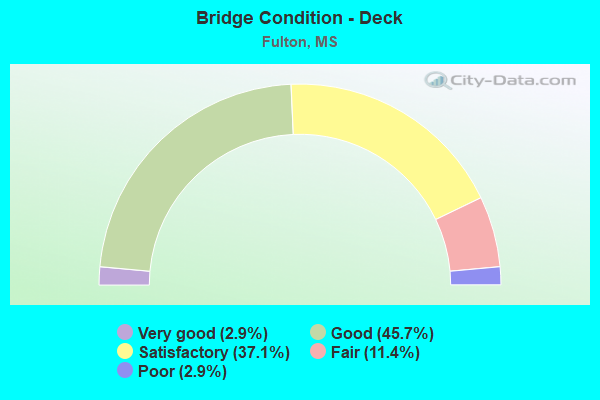
- Bridge Condition - Deck
- 2.9%Very good
- 45.7%Good
- 37.1%Satisfactory
- 11.4%Fair
- 2.9%Poor
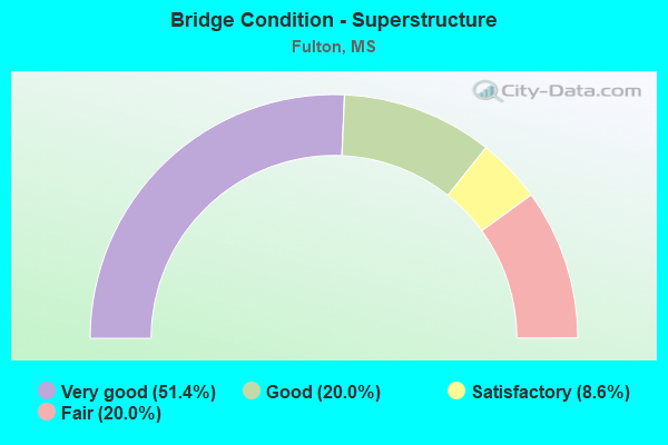
- Bridge Condition - Superstructure
- 51.4%Very good
- 20.0%Good
- 8.6%Satisfactory
- 20.0%Fair
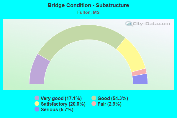
- Bridge Condition - Substructure
- 17.1%Very good
- 54.3%Good
- 20.0%Satisfactory
- 2.9%Fair
- 5.7%Serious
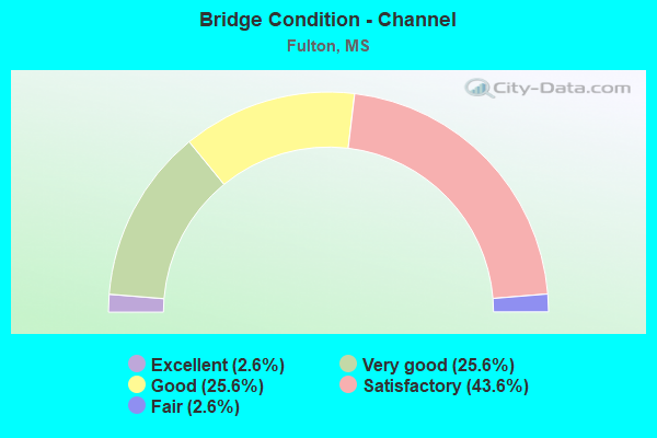
- Bridge Condition - Channel
- 2.6%Excellent
- 25.6%Very good
- 25.6%Good
- 43.6%Satisfactory
- 2.6%Fair
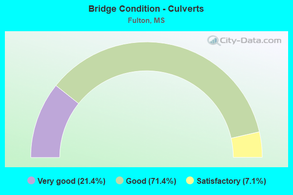
- Bridge Condition - Culverts
- 21.4%Very good
- 71.4%Good
- 7.1%Satisfactory
Find on map >> Show street view
Structure Number: 21000780291028A, Location: US 78 OVER SR 178 (Lat: 34.253556, Lng: -88.460578), Route carried "on" structure: Interstate 22, Year Built: 1984, Status: Open, Structure Length: 10.22m (33.53ft), Average Daily Traffic: 13,000 (year 2020), Truck Traffic: 28%, Average Future Daily Traffic: 18,000 (year 2040), Design Load: HS 20, Features Intersected: SR 178
Minimum Vertical Clearance: 30+ m (98+ ft), Kilometerpoint: 27.045, Lanes on structure: 2, Lanes under structure: 4, Base Highway Network: Yes (Inventory Route: 2, Subroute: 1), Owner: State Highway Agency, Approaching Roadway Width: 13.4m (44.0ft), Skew: 11 degrees, Material/Design: Prestressed concrete continuous, Design/Construction: Stringer/Multi-beam, Number Of Spans In Main Unit: 2, Number Of Approach Spans: 2, Length of Maximum Span: 28.7m (94.2ft), Curb-To-Curb Width: 12.3m (40.4ft), Out-to-Out Width: 13.2m (43.3ft)
Condition: Deck: Satisfactory, Superstructure: Good, Substructure: Good, Operating Rating: 56.5 metric tons, Method Used To Determine Operating Rating: Load Factor (LF), Inventory Rating: 28.9 metric tons, Method Used To Determine Inventory Rating: Load Factor (LF), Structural Evaluation: Better than present minimum criteria, Deck Geometry: Better than present minimum criteria, Underclear: Superior to present desirable criteria, Approach Roadway Alignment: Equal to present desirable criteria, Designated Inspection Frequency: Every 24 months, Inspection Date: May 2020, Deck Structure Type: Concrete Cast-file-Place
Find on map >> Show street view
Structure Number: 21000780291028B, Location: US 78 OVER SR 178 (Lat: 34.254028, Lng: -88.461756), Route carried "on" structure: Interstate 22, Year Built: 1984, Status: Open, Structure Length: 10.22m (33.53ft), Average Daily Traffic: 13,000 (year 2020), Truck Traffic: 28%, Average Future Daily Traffic: 18,000 (year 2040), Design Load: HS 20, Features Intersected: SR 178
Minimum Vertical Clearance: 30+ m (98+ ft), Kilometerpoint: 8.296, Lanes on structure: 2, Lanes under structure: 4, Base Highway Network: Yes (Inventory Route: 2, Subroute: 1), Owner: State Highway Agency, Approaching Roadway Width: 13.4m (44.0ft), Skew: 11 degrees, Material/Design: Prestressed concrete continuous, Design/Construction: Stringer/Multi-beam, Number Of Spans In Main Unit: 2, Number Of Approach Spans: 2, Length of Maximum Span: 28.7m (94.2ft), Curb-To-Curb Width: 12.3m (40.4ft), Out-to-Out Width: 13.2m (43.3ft)
Condition: Deck: Good, Superstructure: Very good, Substructure: Good, Operating Rating: 56.5 metric tons, Method Used To Determine Operating Rating: Load Factor (LF), Inventory Rating: 28.9 metric tons, Method Used To Determine Inventory Rating: Load Factor (LF), Structural Evaluation: Better than present minimum criteria, Deck Geometry: Better than present minimum criteria, Underclear: Superior to present desirable criteria, Approach Roadway Alignment: Equal to present desirable criteria, Designated Inspection Frequency: Every 24 months, Inspection Date: May 2020, Deck Structure Type: Concrete Cast-file-Place
Find on map >> Show street view
Structure Number: 21000780291038A, Location: 6.1 MI E LEE CL (Lat: 34.244353, Lng: -88.447756), Route carried "on" structure: Interstate 22, Year Built: 1984, Status: Open, Structure Length: 6.63m (21.75ft), Average Daily Traffic: 12,500 (year 2020), Truck Traffic: 27%, Average Future Daily Traffic: 17,000 (year 2040), Design Load: HS 20, Features Intersected: BIG OAK ROAD
Minimum Vertical Clearance: 30+ m (98+ ft), Kilometerpoint: 25.484, Lanes on structure: 2, Lanes under structure: 2, Base Highway Network: Yes (Inventory Route: 2, Subroute: 1), Owner: State Highway Agency, Approaching Roadway Width: 13.4m (44.0ft), Skew: 13 degrees, Material/Design: Prestressed concrete continuous, Design/Construction: Stringer/Multi-beam, Number Of Spans In Main Unit: 1, Number Of Approach Spans: 2, Length of Maximum Span: 24.4m (80.1ft), Curb-To-Curb Width: 12.3m (40.4ft), Out-to-Out Width: 13.2m (43.3ft)
Condition: Deck: Good, Superstructure: Good, Substructure: Good, Operating Rating: 52.7 metric tons, Method Used To Determine Operating Rating: Load Factor (LF), Inventory Rating: 27.3 metric tons, Method Used To Determine Inventory Rating: Load Factor (LF), Structural Evaluation: Equal to present minimum criteria, Deck Geometry: Better than present minimum criteria, Underclear: Superior to present desirable criteria, Approach Roadway Alignment: Equal to present desirable criteria, Designated Inspection Frequency: Every 24 months, Inspection Date: May 2020, Deck Structure Type: Concrete Cast-file-Place
Find on map >> Show street view
Structure Number: 21000780291038B, Location: 6.1 MI E LEE CL (Lat: 34.244478, Lng: -88.448394), Route carried "on" structure: Interstate 22, Year Built: 1984, Status: Open, Structure Length: 6.63m (21.75ft), Average Daily Traffic: 12,500 (year 2020), Truck Traffic: 27%, Average Future Daily Traffic: 17,000 (year 2040), Design Load: HS 20, Features Intersected: BIG OAK ROAD
Minimum Vertical Clearance: 30+ m (98+ ft), Kilometerpoint: 9.920, Lanes on structure: 2, Lanes under structure: 2, Base Highway Network: Yes (Inventory Route: 2, Subroute: 1), Owner: State Highway Agency, Approaching Roadway Width: 13.4m (44.0ft), Skew: 13 degrees, Material/Design: Prestressed concrete continuous, Design/Construction: Stringer/Multi-beam, Number Of Spans In Main Unit: 1, Number Of Approach Spans: 2, Length of Maximum Span: 24.4m (80.1ft), Curb-To-Curb Width: 12.3m (40.4ft), Out-to-Out Width: 13.2m (43.3ft)
Condition: Deck: Good, Superstructure: Very good, Substructure: Good, Operating Rating: 52.7 metric tons, Method Used To Determine Operating Rating: Load Factor (LF), Inventory Rating: 27.3 metric tons, Method Used To Determine Inventory Rating: Load Factor (LF), Structural Evaluation: Equal to present minimum criteria, Deck Geometry: Better than present minimum criteria, Underclear: Superior to present desirable criteria, Approach Roadway Alignment: Equal to present desirable criteria, Designated Inspection Frequency: Every 24 months, Inspection Date: May 2020, Deck Structure Type: Concrete Cast-file-Place
Find on map >> Show street view
Structure Number: 21000780291052A, Location: 7.5 MI E LEE CL (Lat: 34.232742, Lng: -88.421253), Route carried "on" structure: Interstate 22, Year Built: 1984, Status: Open, Structure Length: 75.05m (246.23ft), Average Daily Traffic: 12,500 (year 2020), Truck Traffic: 27%, Average Future Daily Traffic: 17,000 (year 2040), Design Load: HS 20, Features Intersected: TOMBIGBEE RIVER
Minimum Vertical Clearance: 30+ m (98+ ft), Kilometerpoint: 22.558, Lanes on structure: 2, Base Highway Network: Yes (Inventory Route: 2, Subroute: 1), Owner: State Highway Agency, Approaching Roadway Width: 13.4m (44.0ft), Skew: 10 degrees, Material/Design: Prestressed concrete, Design/Construction: Stringer/Multi-beam, Number Of Spans In Main Unit: 3, Number Of Approach Spans: 27, Length of Maximum Span: 30.1m (98.8ft), Curb-To-Curb Width: 12.3m (40.4ft), Out-to-Out Width: 13.2m (43.3ft)
Condition: Deck: Good, Superstructure: Good, Substructure: Good, Channel: Satisfactory, Operating Rating: 58.1 metric tons, Method Used To Determine Operating Rating: Load Factor (LF), Inventory Rating: 26.7 metric tons, Method Used To Determine Inventory Rating: Load Factor (LF), Structural Evaluation: Equal to present minimum criteria, Deck Geometry: Better than present minimum criteria, Waterway Adequacy: Superior to present desirable criteria, Approach Roadway Alignment: Equal to present desirable criteria, Designated Inspection Frequency: Every 24 months, Underwater Inspection Frequency: Every 60 months, Inspection Date: May 2020, Underwater Inspection Date: July 2019, Deck Structure Type: Concrete Cast-file-Place
Find on map >> Show street view
Structure Number: 21000780291052B, Location: 7.5 MI E LEE CL (Lat: 34.232125, Lng: -88.429208), Route carried "on" structure: Interstate 22, Year Built: 1984, Status: Open, Structure Length: 75.05m (246.23ft), Average Daily Traffic: 12,500 (year 2020), Truck Traffic: 27%, Average Future Daily Traffic: 17,000 (year 2040), Design Load: HS 20, Features Intersected: TOMBIGBEE RIVER
Minimum Vertical Clearance: 30+ m (98+ ft), Kilometerpoint: 12.171, Lanes on structure: 2, Base Highway Network: Yes (Inventory Route: 2, Subroute: 1), Owner: State Highway Agency, Approaching Roadway Width: 13.4m (44.0ft), Skew: 10 degrees, Material/Design: Prestressed concrete, Design/Construction: Stringer/Multi-beam, Number Of Spans In Main Unit: 3, Number Of Approach Spans: 27, Length of Maximum Span: 30.8m (101.0ft), Curb-To-Curb Width: 12.3m (40.4ft), Out-to-Out Width: 13.2m (43.3ft)
Condition: Deck: Good, Superstructure: Good, Substructure: Good, Channel: Satisfactory, Operating Rating: 55.3 metric tons, Method Used To Determine Operating Rating: Load Factor (LF), Inventory Rating: 22.9 metric tons, Method Used To Determine Inventory Rating: Load Factor (LF), Structural Evaluation: Somewhat better than minimum adequacy, Deck Geometry: Better than present minimum criteria, Waterway Adequacy: Superior to present desirable criteria, Approach Roadway Alignment: Equal to present desirable criteria, Designated Inspection Frequency: Every 24 months, Underwater Inspection Frequency: Every 60 months, Inspection Date: May 2020, Underwater Inspection Date: July 2019, Deck Structure Type: Concrete Cast-file-Place
Find on map >> Show street view
Structure Number: 21000780291059A, Location: 8.2 MI E LEE CL (Lat: 34.240467, Lng: -88.407633), Route carried "on" structure: Interstate 22, Year Built: 1984, Status: Open, Structure Length: 105.53m (346.23ft), Average Daily Traffic: 12,500 (year 2020), Truck Traffic: 27%, Average Future Daily Traffic: 17,000 (year 2040), Design Load: HS 20, Features Intersected: TENNTOM MISSISSIPPIAN RR
Minimum Vertical Clearance: 30+ m (98+ ft), Kilometerpoint: 21.036, Lanes on structure: 2, Base Highway Network: Yes (Inventory Route: 2, Subroute: 1), Owner: State Highway Agency, Approaching Roadway Width: 13.4m (44.0ft), Skew: 10 degrees, Navigation Control: Yes ( Vertical Clearance: 16.0m (52.5ft), Horizontal Clearance: 91.0m (298.6ft)), Material/Design: Steel continuous, Design/Construction: Stringer/Multi-beam, Number Of Spans In Main Unit: 3, Number Of Approach Spans: 25, Length of Maximum Span: 121.9m (399.9ft), Curb-To-Curb Width: 12.3m (40.4ft), Out-to-Out Width: 13.2m (43.3ft)
Condition: Deck: Good, Superstructure: Good, Substructure: Good, Channel: Satisfactory, Operating Rating: 55.1 metric tons, Method Used To Determine Operating Rating: Load Factor (LF), Inventory Rating: 25.2 metric tons, Method Used To Determine Inventory Rating: Load Factor (LF), Structural Evaluation: Equal to present minimum criteria, Deck Geometry: Better than present minimum criteria, Underclear: Superior to present desirable criteria, Waterway Adequacy: Equal to present desirable criteria, Approach Roadway Alignment: Equal to present desirable criteria, Designated Inspection Frequency: Every 24 months, Underwater Inspection Frequency: Every 60 months, Inspection Date: October 2021, Underwater Inspection Date: July 2019, Deck Structure Type: Concrete Cast-file-Place
Find on map >> Show street view
Structure Number: 21000780291059B, Location: 8.2 MI E LEE CL (Lat: 34.234717, Lng: -88.416797), Route carried "on" structure: Interstate 22, Year Built: 1984, Status: Open, Structure Length: 105.53m (346.23ft), Average Daily Traffic: 12,500 (year 2020), Truck Traffic: 27%, Average Future Daily Traffic: 17,000 (year 2040), Design Load: HS 20, Features Intersected: TENNTOM MISSISSIPPIAN RR
Minimum Vertical Clearance: 30+ m (98+ ft), Kilometerpoint: 13.399, Lanes on structure: 2, Base Highway Network: Yes (Inventory Route: 2, Subroute: 1), Owner: State Highway Agency, Approaching Roadway Width: 13.4m (44.0ft), Skew: 10 degrees, Navigation Control: Yes ( Vertical Clearance: 16.0m (52.5ft), Horizontal Clearance: 91.0m (298.6ft)), Material/Design: Steel continuous, Design/Construction: Stringer/Multi-beam, Number Of Spans In Main Unit: 3, Number Of Approach Spans: 25, Length of Maximum Span: 121.9m (399.9ft), Curb-To-Curb Width: 12.3m (40.4ft), Out-to-Out Width: 13.2m (43.3ft)
Condition: Deck: Good, Superstructure: Good, Substructure: Good, Channel: Satisfactory, Operating Rating: 52.1 metric tons, Method Used To Determine Operating Rating: Load Factor (LF), Inventory Rating: 24.6 metric tons, Method Used To Determine Inventory Rating: Load Factor (LF), Structural Evaluation: Equal to present minimum criteria, Deck Geometry: Better than present minimum criteria, Underclear: Equal to present minimum criteria, Waterway Adequacy: Equal to present desirable criteria, Approach Roadway Alignment: Equal to present desirable criteria, Designated Inspection Frequency: Every 24 months, Underwater Inspection Frequency: Every 60 months, Inspection Date: October 2021, Underwater Inspection Date: July 2019, Deck Structure Type: Concrete Cast-file-Place
Find on map >> Show street view
Structure Number: 21000780291094A, Location: 11.7 MI E LEE CL (Lat: 34.243014, Lng: -88.359425), Route carried "on" structure: Interstate 22, Year Built: 1988, Status: Open, Structure Length: 7.36m (24.15ft), Average Daily Traffic: 8,500 (year 2020), Truck Traffic: 39%, Average Future Daily Traffic: 11,500 (year 2040), Design Load: HS 20, Features Intersected: REEDS CREEK
Minimum Vertical Clearance: 30+ m (98+ ft), Kilometerpoint: 16.452, Lanes on structure: 2, Base Highway Network: Yes (Inventory Route: 2, Subroute: 1), Owner: State Highway Agency, Approaching Roadway Width: 13.4m (44.0ft), Skew: 10 degrees, Material/Design: Prestressed concrete continuous, Design/Construction: Stringer/Multi-beam, Number Of Spans In Main Unit: 6, Length of Maximum Span: 12.2m (40.0ft), Curb-To-Curb Width: 12.3m (40.4ft), Out-to-Out Width: 13.2m (43.3ft)
Condition: Deck: Satisfactory, Superstructure: Very good, Substructure: Good, Channel: Good, Operating Rating: 56.8 metric tons, Method Used To Determine Operating Rating: Load Factor (LF), Inventory Rating: 34.0 metric tons, Method Used To Determine Inventory Rating: Load Factor (LF), Structural Evaluation: Better than present minimum criteria, Deck Geometry: Better than present minimum criteria, Waterway Adequacy: Superior to present desirable criteria, Approach Roadway Alignment: Equal to present desirable criteria, Designated Inspection Frequency: Every 24 months, Inspection Date: May 2020, Deck Structure Type: Concrete Cast-file-Place
Find on map >> Show street view
Structure Number: 21000780291094B, Location: 11.7 MI E LEE CL (Lat: 34.242967, Lng: -88.360278), Route carried "on" structure: Interstate 22, Year Built: 1988, Status: Open, Structure Length: 7.36m (24.15ft), Average Daily Traffic: 8,500 (year 2020), Truck Traffic: 39%, Average Future Daily Traffic: 11,500 (year 2040), Design Load: HS 20, Features Intersected: REEDS CREEK
Minimum Vertical Clearance: 30+ m (98+ ft), Kilometerpoint: 18.942, Lanes on structure: 2, Base Highway Network: Yes (Inventory Route: 2, Subroute: 1), Owner: State Highway Agency, Approaching Roadway Width: 13.4m (44.0ft), Skew: 10 degrees, Material/Design: Prestressed concrete continuous, Design/Construction: Stringer/Multi-beam, Number Of Spans In Main Unit: 6, Length of Maximum Span: 12.2m (40.0ft), Curb-To-Curb Width: 12.3m (40.4ft), Out-to-Out Width: 13.2m (43.3ft)
Condition: Deck: Satisfactory, Superstructure: Very good, Substructure: Good, Channel: Good, Operating Rating: 68.8 metric tons, Method Used To Determine Operating Rating: Load Factor (LF), Inventory Rating: 41.2 metric tons, Method Used To Determine Inventory Rating: Load Factor (LF), Structural Evaluation: Better than present minimum criteria, Deck Geometry: Better than present minimum criteria, Waterway Adequacy: Superior to present desirable criteria, Approach Roadway Alignment: Equal to present desirable criteria, Designated Inspection Frequency: Every 24 months, Inspection Date: May 2020, Deck Structure Type: Concrete Cast-file-Place
Find on map >> Show street view
Structure Number: 21000780291107A, Location: 13.0 MI E LEE CL (Lat: 34.237328, Lng: -88.339358), Route carried "on" structure: State highway 25, Year Built: 1988, Status: Open, Structure Length: 9.85m (32.32ft), Average Daily Traffic: 850 (year 2020), Truck Traffic: 17%, Average Future Daily Traffic: 1,100 (year 2040), Design Load: HS 20, Features Intersected: I 22
Minimum Vertical Clearance: 30+ m (98+ ft), Kilometerpoint: 11.459, Lanes on structure: 2, Lanes under structure: 4, Base Highway Network: Yes (Inventory Route: 2, Subroute: 1), Owner: State Highway Agency, Approaching Roadway Width: 12.8m (42.0ft), Skew: 10 degrees, Material/Design: Prestressed concrete continuous, Design/Construction: Stringer/Multi-beam, Number Of Spans In Main Unit: 2, Number Of Approach Spans: 2, Length of Maximum Span: 26.8m (87.9ft), Curb-To-Curb Width: 12.2m (40.0ft), Out-to-Out Width: 13.0m (42.7ft)
Condition: Deck: Satisfactory, Superstructure: Very good, Substructure: Good, Operating Rating: 65.7 metric tons, Method Used To Determine Operating Rating: Load Factor (LF), Inventory Rating: 42.0 metric tons, Method Used To Determine Inventory Rating: Load Factor (LF), Structural Evaluation: Better than present minimum criteria, Deck Geometry: Better than present minimum criteria, Underclear: Somewhat better than minimum adequacy, Approach Roadway Alignment: Equal to present desirable criteria, Designated Inspection Frequency: Every 24 months, Inspection Date: May 2020, Deck Structure Type: Concrete Cast-file-Place, Wearing Surface/Protective System: Wearing Surface: Low Slump Concrete
Find on map >> Show street view
Structure Number: 21000780291107B, Location: 13.0 MI E LEE CL (Lat: 34.236378, Lng: -88.339467), Route carried "on" structure: State highway 25, Year Built: 1988, Status: Open, Structure Length: 9.85m (32.32ft), Average Daily Traffic: 850 (year 2020), Truck Traffic: 24%, Average Future Daily Traffic: 1,100 (year 2040), Design Load: HS 20, Features Intersected: I 22
Minimum Vertical Clearance: 30+ m (98+ ft), Kilometerpoint: 22.487, Lanes on structure: 2, Lanes under structure: 4, Base Highway Network: Yes (Inventory Route: 2, Subroute: 2), Owner: State Highway Agency, Approaching Roadway Width: 12.8m (42.0ft), Skew: 10 degrees, Material/Design: Prestressed concrete continuous, Design/Construction: Stringer/Multi-beam, Number Of Spans In Main Unit: 2, Number Of Approach Spans: 2, Length of Maximum Span: 26.8m (87.9ft), Curb-To-Curb Width: 12.2m (40.0ft), Out-to-Out Width: 13.0m (42.7ft)
Condition: Deck: Satisfactory, Superstructure: Very good, Substructure: Good, Operating Rating: 65.7 metric tons, Method Used To Determine Operating Rating: Load Factor (LF), Inventory Rating: 42.0 metric tons, Method Used To Determine Inventory Rating: Load Factor (LF), Structural Evaluation: Better than present minimum criteria, Deck Geometry: Better than present minimum criteria, Underclear: Equal to present minimum criteria, Approach Roadway Alignment: Equal to present desirable criteria, Designated Inspection Frequency: Every 24 months, Inspection Date: May 2020, Deck Structure Type: Concrete Cast-file-Place
Find on map >> Show street view
Structure Number: 3100025029157, Location: 9.8 MI N MONROE CL (Lat: 34.205389, Lng: -88.375719), Route carried "on" structure: State highway 25, Year Built: 1951, Status: Open, Structure Length: 6.10m (20.01ft), Average Daily Traffic: 2,400 (year 2020), Truck Traffic: 11%, Average Future Daily Traffic: 2,400 (year 2040), Design Load: HS 15, Features Intersected: REED CREEK
Minimum Vertical Clearance: 30+ m (98+ ft), Kilometerpoint: 16.206, Lanes on structure: 2, Owner: State Highway Agency, Approaching Roadway Width: 9.8m (32.2ft), Material/Design: Steel, Design/Construction: Stringer/Multi-beam, Number Of Spans In Main Unit: 5, Length of Maximum Span: 12.2m (40.0ft), Curb or Sidewalk Widths: Left: 0.5m (1.6ft), Right: 0.5m (1.6ft), Curb-To-Curb Width: 7.9m (25.9ft), Out-to-Out Width: 8.5m (27.9ft)
Condition: Deck: Satisfactory, Superstructure: Satisfactory, Substructure: Satisfactory, Channel: Satisfactory, Operating Rating: 41.0 metric tons, Method Used To Determine Operating Rating: Load Factor (LF), Inventory Rating: 24.6 metric tons, Method Used To Determine Inventory Rating: Load Factor (LF), Structural Evaluation: Equal to present minimum criteria, Deck Geometry: High priority of corrective action, Waterway Adequacy: Equal to present minimum criteria, Approach Roadway Alignment: Equal to present desirable criteria, Length Of Structure Improvement: 7.85m (25.75ft), Designated Inspection Frequency: Every 24 months, Inspection Date: May 2020, Bridge Improvement Cost: $722,000,000, Roadway Improvement Cost: $72,000,000, Total Project Cost: $999,999,000, Deck Structure Type: Concrete Cast-file-Place, Wearing Surface/Protective System: Wearing Surface: Bituminous
Find on map >> Show street view
Structure Number: 31000250291601A, Location: 12.9 MI N MONROE CL (Lat: 34.242869, Lng: -88.402931), Route carried "on" structure: State highway 25, Year Built: 1984, Status: Open, Structure Length: 10.13m (33.23ft), Average Daily Traffic: 1,950 (year 2020), Truck Traffic: 9%, Average Future Daily Traffic: 2,550 (year 2040), Design Load: HS 20, Features Intersected: I 22
Minimum Vertical Clearance: 30+ m (98+ ft), Kilometerpoint: 12.320, Lanes on structure: 2, Lanes under structure: 4, Base Highway Network: Yes (Inventory Route: 2, Subroute: 2), Owner: State Highway Agency, Approaching Roadway Width: 12.8m (42.0ft), Skew: 11 degrees, Material/Design: Prestressed concrete continuous, Design/Construction: Stringer/Multi-beam, Number Of Spans In Main Unit: 2, Number Of Approach Spans: 2, Length of Maximum Span: 27.4m (89.9ft), Curb-To-Curb Width: 12.2m (40.0ft), Out-to-Out Width: 13.0m (42.7ft)
Condition: Deck: Satisfactory, Superstructure: Good, Substructure: Good, Operating Rating: 52.7 metric tons, Method Used To Determine Operating Rating: Load Factor (LF), Inventory Rating: 27.8 metric tons, Method Used To Determine Inventory Rating: Load Factor (LF), Structural Evaluation: Equal to present minimum criteria, Deck Geometry: Better than present minimum criteria, Underclear: Somewhat better than minimum adequacy, Approach Roadway Alignment: Equal to present desirable criteria, Designated Inspection Frequency: Every 24 months, Inspection Date: May 2020, Deck Structure Type: Concrete Cast-file-Place
Find on map >> Show street view
Structure Number: 31000250291601B, Location: 12.9 MI N MONROE CL (Lat: 34.242044, Lng: -88.402492), Route carried "on" structure: State highway 25, Year Built: 1984, Status: Open, Structure Length: 10.13m (33.23ft), Average Daily Traffic: 1,950 (year 2020), Truck Traffic: 9%, Average Future Daily Traffic: 2,550 (year 2040), Design Load: HS 20, Features Intersected: I 22
Minimum Vertical Clearance: 30+ m (98+ ft), Kilometerpoint: 21.171, Lanes on structure: 2, Lanes under structure: 4, Base Highway Network: Yes (Inventory Route: 2, Subroute: 1), Owner: State Highway Agency, Approaching Roadway Width: 12.8m (42.0ft), Skew: 11 degrees, Material/Design: Prestressed concrete continuous, Design/Construction: Stringer/Multi-beam, Number Of Spans In Main Unit: 2, Number Of Approach Spans: 2, Length of Maximum Span: 27.4m (89.9ft), Curb-To-Curb Width: 12.2m (40.0ft), Out-to-Out Width: 13.0m (42.7ft)
Condition: Deck: Satisfactory, Superstructure: Very good, Substructure: Good, Operating Rating: 52.7 metric tons, Method Used To Determine Operating Rating: Load Factor (LF), Inventory Rating: 27.8 metric tons, Method Used To Determine Inventory Rating: Load Factor (LF), Structural Evaluation: Equal to present minimum criteria, Deck Geometry: Better than present minimum criteria, Underclear: Somewhat better than minimum adequacy, Approach Roadway Alignment: Equal to present desirable criteria, Designated Inspection Frequency: Every 24 months, Inspection Date: May 2020, Deck Structure Type: Concrete Cast-file-Place
Find on map >> Show street view
Structure Number: 31000250291603, Location: 13.0 MI N MONROE CL (Lat: 34.244289, Lng: -88.403097), Route carried "on" structure: State highway 25, Year Built: 1985, Status: Open, Structure Length: 0.63m (2.07ft), Average Daily Traffic: 3,900 (year 2020), Truck Traffic: 9%, Average Future Daily Traffic: 5,100 (year 2040), Design Load: HS 20, Features Intersected: CREEK
Minimum Vertical Clearance: 30+ m (98+ ft), Kilometerpoint: 21.425, Lanes on structure: 4, Base Highway Network: Yes (Inventory Route: 2, Subroute: 1), Owner: State Highway Agency, Approaching Roadway Width: 25.6m (84.0ft), Skew: 10 degrees, Material/Design: Concrete, Design/Construction: Culvert, Number Of Spans In Main Unit: 2, Length of Maximum Span: 3.0m (9.8ft)
Condition: Channel: Good, Culverts: Good, Operating Rating: 99.8 metric tons, Method Used To Determine Operating Rating: Load Factor (LF), Inventory Rating: 99.8 metric tons, Method Used To Determine Inventory Rating: Load Factor (LF), Structural Evaluation: Better than present minimum criteria, Waterway Adequacy: Superior to present desirable criteria, Approach Roadway Alignment: Equal to present desirable criteria, Designated Inspection Frequency: Every 24 months, Inspection Date: May 2020
Find on map >> Show street view
Structure Number: 31000250291604, Location: 13.1 MI N MONROE CL (Lat: 34.246325, Lng: -88.403628), Route carried "on" structure: State highway 25, Year Built: 1985, Status: Open, Structure Length: 1.16m (3.81ft), Average Daily Traffic: 11,000 (year 2020), Truck Traffic: 4%, Average Future Daily Traffic: 11,000 (year 2040), Design Load: HS 20, Features Intersected: CREEK
Minimum Vertical Clearance: 30+ m (98+ ft), Kilometerpoint: 0.064, Lanes on structure: 4, Owner: State Highway Agency, Approaching Roadway Width: 25.6m (84.0ft), Skew: 13 degrees, Material/Design: Concrete, Design/Construction: Culvert, Number Of Spans In Main Unit: 2, Length of Maximum Span: 4.9m (16.1ft)
Condition: Channel: Satisfactory, Culverts: Good, Operating Rating: 99.8 metric tons, Method Used To Determine Operating Rating: Load Factor (LF), Inventory Rating: 99.8 metric tons, Method Used To Determine Inventory Rating: Load Factor (LF), Structural Evaluation: Better than present minimum criteria, Waterway Adequacy: Superior to present desirable criteria, Approach Roadway Alignment: Equal to present desirable criteria, Designated Inspection Frequency: Every 24 months, Inspection Date: May 2020
Find on map >> Show street view
Structure Number: 31001780291027, Location: 4.6 MI E LEE CL (Lat: 34.252614, Lng: -88.476861), Route carried "on" structure: State highway 178, Year Built: 1949, Status: Open, Structure Length: 9.51m (31.20ft), Average Daily Traffic: 2,300 (year 2020), Truck Traffic: 6%, Average Future Daily Traffic: 2,300 (year 2040), Design Load: HS 15, Features Intersected: MANTACHIE CANAL
Minimum Vertical Clearance: 4.57m (14.99ft), Kilometerpoint: 6.383, Lanes on structure: 2, Owner: State Highway Agency, Approaching Roadway Width: 10.4m (34.1ft), Material/Design: Steel, Design/Construction: Truss - Thru, Number Of Spans In Main Unit: 1, Number Of Approach Spans: 4, Length of Maximum Span: 46.3m (151.9ft), Curb or Sidewalk Widths: Left: 0.5m (1.6ft), Right: 0.5m (1.6ft), Curb-To-Curb Width: 7.9m (25.9ft), Out-to-Out Width: 8.5m (27.9ft)
Condition: Deck: Fair, Superstructure: Fair, Substructure: Satisfactory, Channel: Satisfactory, Operating Rating: 35.2 metric tons, Method Used To Determine Operating Rating: Load Factor (LF), Inventory Rating: 21.1 metric tons, Method Used To Determine Inventory Rating: Load Factor (LF), Structural Evaluation: Somewhat better than minimum adequacy, Deck Geometry: High priority of corrective action, Waterway Adequacy: Equal to present minimum criteria, Approach Roadway Alignment: Equal to present desirable criteria, Length Of Structure Improvement: 12.10m (39.70ft), Designated Inspection Frequency: Every 24 months, Critical Feature Inspection Frequency: Every 12 months, Inspection Date: September 2021, Critical Feature Inspection Date: September 2021, Bridge Improvement Cost: $999,999,000, Roadway Improvement Cost: $113,000,000, Total Project Cost: $999,999,000, Deck Structure Type: Concrete Cast-file-Place, Wearing Surface/Protective System: Wearing Surface: Bituminous
Find on map >> Show street view
Structure Number: 31001780291028, Location: 4.7 MI E LEE CL (Lat: 34.252117, Lng: -88.474017), Route carried "on" structure: State highway 178, Year Built: 1947, Status: Posted for load, Structure Length: 3.66m (12.01ft), Average Daily Traffic: 2,300 (year 2020), Truck Traffic: 6%, Average Future Daily Traffic: 2,300 (year 2040), Design Load: HS 15, Features Intersected: OLD CREEK RUN
Minimum Vertical Clearance: 30+ m (98+ ft), Kilometerpoint: 6.651, Lanes on structure: 2, Owner: State Highway Agency, Approaching Roadway Width: 10.4m (34.1ft), Material/Design: Concrete, Design/Construction: Tee Beam, Number Of Spans In Main Unit: 3, Length of Maximum Span: 12.2m (40.0ft), Curb or Sidewalk Widths: Left: 0.5m (1.6ft), Right: 0.5m (1.6ft), Curb-To-Curb Width: 7.9m (25.9ft), Out-to-Out Width: 8.5m (27.9ft)
Condition: Deck: Satisfactory, Superstructure: Satisfactory, Substructure: Satisfactory, Channel: Satisfactory, Operating Rating: 31.3 metric tons, Method Used To Determine Operating Rating: Load Factor (LF), Inventory Rating: 18.8 metric tons, Method Used To Determine Inventory Rating: Load Factor (LF), Structural Evaluation: Somewhat better than minimum adequacy, Deck Geometry: High priority of corrective action, Waterway Adequacy: Equal to present desirable criteria, Approach Roadway Alignment: Equal to present desirable criteria, Bridge Posting: Required (Relationship of Operating Rating to Maximum Legal Load: 10.0 - 19.9% below), Length Of Structure Improvement: 4.75m (15.58ft), Designated Inspection Frequency: Every 12 months, Inspection Date: August 2021, Bridge Improvement Cost: $392,000,000, Roadway Improvement Cost: $39,000,000, Total Project Cost: $999,999,000, Deck Structure Type: Concrete Cast-file-Place, Wearing Surface/Protective System: Wearing Surface: Bituminous
Find on map >> Show street view
Structure Number: 31001780291048, Location: 6.1 MI E LEE CL (Lat: 34.264800, Lng: -88.445786), Route carried "on" structure: State highway 178, Year Built: 1931, Status: Posted for load, Structure Length: 11.86m (38.91ft), Average Daily Traffic: 200 (year 2020), Truck Traffic: 10%, Average Future Daily Traffic: 200 (year 2040), Design Load: H 15, Features Intersected: TOMBIGBEE RIVER
Minimum Vertical Clearance: 30+ m (98+ ft), Kilometerpoint: 9.762, Lanes on structure: 2, Owner: State Highway Agency, Approaching Roadway Width: 10.4m (34.1ft), Material/Design: Steel continuous, Design/Construction: Stringer/Multi-beam, Number Of Spans In Main Unit: 3, Number Of Approach Spans: 6, Length of Maximum Span: 27.4m (89.9ft), Curb or Sidewalk Widths: Left: 0.2m (0.7ft), Right: 0.2m (0.7ft), Curb-To-Curb Width: 7.3m (24.0ft), Out-to-Out Width: 7.6m (24.9ft)
Condition: Deck: Fair, Superstructure: Fair, Substructure: Satisfactory, Channel: Satisfactory, Operating Rating: 29.0 metric tons, Method Used To Determine Operating Rating: Load Factor (LF), Inventory Rating: 17.3 metric tons, Method Used To Determine Inventory Rating: Load Factor (LF), Structural Evaluation: Somewhat better than minimum adequacy, Deck Geometry: Somewhat better than minimum adequacy, Waterway Adequacy: Equal to present minimum criteria, Approach Roadway Alignment: Equal to present desirable criteria, Bridge Posting: Required (Relationship of Operating Rating to Maximum Legal Load: 10.0 - 19.9% below), Length Of Structure Improvement: 11.86m (38.91ft), Designated Inspection Frequency: Every 12 months, Underwater Inspection Frequency: Every 60 months, Inspection Date: August 2021, Underwater Inspection Date: July 2019, Bridge Improvement Cost: $175,000,000, Roadway Improvement Cost: $130,000,000, Total Project Cost: $354,000,000, Deck Structure Type: Concrete Cast-file-Place, Wearing Surface/Protective System: Wearing Surface: Bituminous
Find on map >> Show street view
Structure Number: 3100178029105, Location: 6.3 MI E LEE CL (Lat: 34.267189, Lng: -88.442569), Route carried "on" structure: State highway 178, Year Built: 1931, Status: Open, Structure Length: 2.74m (8.99ft), Average Daily Traffic: 200 (year 2020), Truck Traffic: 10%, Average Future Daily Traffic: 200 (year 2040), Design Load: H 15, Features Intersected: RELIEF
Minimum Vertical Clearance: 30+ m (98+ ft), Kilometerpoint: 10.160, Lanes on structure: 2, Owner: State Highway Agency, Approaching Roadway Width: 9.8m (32.2ft), Material/Design: Steel, Design/Construction: Stringer/Multi-beam, Number Of Spans In Main Unit: 3, Length of Maximum Span: 9.1m (29.9ft), Curb or Sidewalk Widths: Left: 0.2m (0.7ft), Right: 0.2m (0.7ft), Curb-To-Curb Width: 7.3m (24.0ft), Out-to-Out Width: 7.6m (24.9ft)
Condition: Deck: Satisfactory, Superstructure: Satisfactory, Substructure: Satisfactory, Channel: Satisfactory, Operating Rating: 43.7 metric tons, Method Used To Determine Operating Rating: Load Factor (LF), Inventory Rating: 26.2 metric tons, Method Used To Determine Inventory Rating: Load Factor (LF), Structural Evaluation: Equal to present minimum criteria, Deck Geometry: Somewhat better than minimum adequacy, Waterway Adequacy: Equal to present minimum criteria, Approach Roadway Alignment: Equal to present desirable criteria, Length Of Structure Improvement: 2.74m (8.99ft), Designated Inspection Frequency: Every 24 months, Underwater Inspection Frequency: Every 60 months, Inspection Date: August 2020, Underwater Inspection Date: July 2019, Bridge Improvement Cost: $51,000,000, Roadway Improvement Cost: $130,000,000, Total Project Cost: $210,000,000, Deck Structure Type: Concrete Cast-file-Place, Wearing Surface/Protective System: Wearing Surface: Bituminous
Find on map >> Show street view
Structure Number: 31001780291052, Location: 6.5 MI E LEE CL (Lat: 34.268714, Lng: -88.439986), Route carried "on" structure: State highway 178, Year Built: 1931, Status: Open, Structure Length: 2.74m (8.99ft), Average Daily Traffic: 200 (year 2020), Truck Traffic: 10%, Average Future Daily Traffic: 200 (year 2040), Design Load: H 15, Features Intersected: RELIEF
Minimum Vertical Clearance: 30+ m (98+ ft), Kilometerpoint: 10.451, Lanes on structure: 2, Owner: State Highway Agency, Approaching Roadway Width: 9.8m (32.2ft), Material/Design: Steel, Design/Construction: Stringer/Multi-beam, Number Of Spans In Main Unit: 3, Length of Maximum Span: 9.1m (29.9ft), Curb or Sidewalk Widths: Left: 0.2m (0.7ft), Right: 0.2m (0.7ft), Curb-To-Curb Width: 7.3m (24.0ft), Out-to-Out Width: 7.6m (24.9ft)
Condition: Deck: Satisfactory, Superstructure: Fair, Substructure: Satisfactory, Channel: Very good, Operating Rating: 41.0 metric tons, Method Used To Determine Operating Rating: Load Factor (LF), Inventory Rating: 24.5 metric tons, Method Used To Determine Inventory Rating: Load Factor (LF), Structural Evaluation: Somewhat better than minimum adequacy, Deck Geometry: Somewhat better than minimum adequacy, Waterway Adequacy: Equal to present minimum criteria, Approach Roadway Alignment: Equal to present desirable criteria, Length Of Structure Improvement: 2.74m (8.99ft), Designated Inspection Frequency: Every 24 months, Underwater Inspection Frequency: Every 60 months, Inspection Date: August 2020, Underwater Inspection Date: July 2019, Bridge Improvement Cost: $41,000,000, Roadway Improvement Cost: $130,000,000, Total Project Cost: $198,000,000, Deck Structure Type: Concrete Cast-file-Place, Wearing Surface/Protective System: Wearing Surface: Bituminous
Find on map >> Show street view
Structure Number: 31001780291054, Location: 6.7 MI E LEE CL (Lat: 34.269717, Lng: -88.437533), Route carried "on" structure: State highway 178, Year Built: 1938, Status: Posted for load, Structure Length: 3.66m (12.01ft), Average Daily Traffic: 200 (year 2020), Truck Traffic: 10%, Average Future Daily Traffic: 200 (year 2040), Design Load: H 15, Features Intersected: RELIEF
Minimum Vertical Clearance: 30+ m (98+ ft), Kilometerpoint: 10.704, Lanes on structure: 2, Owner: State Highway Agency, Approaching Roadway Width: 9.8m (32.2ft), Material/Design: Steel, Design/Construction: Stringer/Multi-beam, Number Of Spans In Main Unit: 6, Length of Maximum Span: 6.1m (20.0ft), Curb or Sidewalk Widths: Left: 0.2m (0.7ft), Right: 0.2m (0.7ft), Curb-To-Curb Width: 7.3m (24.0ft), Out-to-Out Width: 8.1m (26.6ft)
Condition: Deck: Fair, Superstructure: Fair, Substructure: Serious, Channel: Satisfactory, Structural Evaluation: High priority of replacement, Deck Geometry: Somewhat better than minimum adequacy, Waterway Adequacy: Equal to present desirable criteria, Approach Roadway Alignment: Equal to present desirable criteria, Bridge Posting: Required (Relationship of Operating Rating to Maximum Legal Load: > 39.9% below), Length Of Structure Improvement: 4.75m (15.58ft), Designated Inspection Frequency: Every 12 months, Underwater Inspection Frequency: Every 30 months, Inspection Date: August 2021, Underwater Inspection Date: July 2019, Bridge Improvement Cost: $392,000,000, Roadway Improvement Cost: $39,000,000, Total Project Cost: $999,999,000, Deck Structure Type: Concrete Cast-file-Place, Wearing Surface/Protective System: Wearing Surface: Bituminous
Find on map >> Show street view
Structure Number: 31001780291057, Location: 7.0 MI E LEE CL (Lat: 34.271408, Lng: -88.432244), Route carried "on" structure: State highway 178, Year Built: 1938, Status: Posted for load, Structure Length: 6.10m (20.01ft), Average Daily Traffic: 200 (year 2020), Truck Traffic: 10%, Average Future Daily Traffic: 200 (year 2040), Design Load: H 15, Features Intersected: RELIEF
Minimum Vertical Clearance: 30+ m (98+ ft), Kilometerpoint: 11.225, Lanes on structure: 2, Owner: State Highway Agency, Approaching Roadway Width: 9.8m (32.2ft), Material/Design: Steel, Design/Construction: Stringer/Multi-beam, Number Of Spans In Main Unit: 10, Length of Maximum Span: 6.1m (20.0ft), Curb or Sidewalk Widths: Left: 0.2m (0.7ft), Right: 0.2m (0.7ft), Curb-To-Curb Width: 7.3m (24.0ft), Out-to-Out Width: 8.1m (26.6ft)
Condition: Deck: Poor, Superstructure: Fair, Substructure: Serious, Channel: Good, Structural Evaluation: High priority of corrective action, Deck Geometry: Somewhat better than minimum adequacy, Waterway Adequacy: Equal to present minimum criteria, Approach Roadway Alignment: Equal to present desirable criteria, Bridge Posting: Required (Relationship of Operating Rating to Maximum Legal Load: 20.0 - 29.9% below), Length Of Structure Improvement: 6.10m (20.01ft), Designated Inspection Frequency: Every 12 months, Underwater Inspection Frequency: Every 30 months, Inspection Date: August 2021, Underwater Inspection Date: July 2019, Bridge Improvement Cost: $90,000,000, Roadway Improvement Cost: $130,000,000, Total Project Cost: $255,000,000, Deck Structure Type: Concrete Cast-file-Place, Wearing Surface/Protective System: Wearing Surface: Bituminous
Find on map >> Show street view
Structure Number: 41000780291085, Location: 10.8 MI E LEE CL (Lat: 34.245483, Lng: -88.375072), Route carried "on" structure: County highway , Year Built: 1988, Status: Open, Structure Length: 10.87m (35.66ft), Average Daily Traffic: 670 (year 2020), Truck Traffic: 11%, Average Future Daily Traffic: 670 (year 2040), Design Load: HS 20, Features Intersected: I 22, Facility Carried by Structure: HARDENS CHAPEL RD
Minimum Vertical Clearance: 30+ m (98+ ft), Kilometerpoint: 3.323, Lanes on structure: 2, Lanes under structure: 4, Owner: State Highway Agency, Approaching Roadway Width: 10.4m (34.1ft), Skew: 3 degrees, Material/Design: Prestressed concrete continuous, Design/Construction: Stringer/Multi-beam, Number Of Spans In Main Unit: 2, Number Of Approach Spans: 2, Length of Maximum Span: 31.1m (102.0ft), Curb-To-Curb Width: 8.7m (28.5ft), Out-to-Out Width: 9.5m (31.2ft)
Condition: Deck: Good, Superstructure: Very good, Substructure: Good, Operating Rating: 71.9 metric tons, Method Used To Determine Operating Rating: Load Factor (LF), Inventory Rating: 36.6 metric tons, Method Used To Determine Inventory Rating: Load Factor (LF), Structural Evaluation: Better than present minimum criteria, Deck Geometry: Somewhat better than minimum adequacy, Underclear: Somewhat better than minimum adequacy, Approach Roadway Alignment: Equal to present desirable criteria, Designated Inspection Frequency: Every 24 months, Inspection Date: May 2020, Deck Structure Type: Concrete Cast-file-Place
Find on map >> Show street view
Structure Number: 41000780291113, Location: 13.6 MI E LEE CL (Lat: 34.233531, Lng: -88.329939), Route carried "on" structure: County highway , Year Built: 1989, Status: Open, Structure Length: 9.52m (31.23ft), Average Daily Traffic: 510 (year 2020), Truck Traffic: 8%, Average Future Daily Traffic: 510 (year 2040), Design Load: HS 20, Features Intersected: I 22, Facility Carried by Structure: CLAY TILDEN ROAD
Minimum Vertical Clearance: 30+ m (98+ ft), Kilometerpoint: 6.484, Lanes on structure: 2, Lanes under structure: 4, Owner: State Highway Agency, Approaching Roadway Width: 9.1m (29.9ft), Material/Design: Prestressed concrete continuous, Design/Construction: Stringer/Multi-beam, Number Of Spans In Main Unit: 2, Number Of Approach Spans: 2, Length of Maximum Span: 27.4m (89.9ft), Curb-To-Curb Width: 9.1m (29.9ft), Out-to-Out Width: 10.0m (32.8ft)
Condition: Deck: Good, Superstructure: Very good, Substructure: Good, Operating Rating: 51.4 metric tons, Method Used To Determine Operating Rating: Load Factor (LF), Inventory Rating: 24.1 metric tons, Method Used To Determine Inventory Rating: Load Factor (LF), Structural Evaluation: Equal to present minimum criteria, Deck Geometry: Equal to present minimum criteria, Underclear: Somewhat better than minimum adequacy, Approach Roadway Alignment: Equal to present desirable criteria, Designated Inspection Frequency: Every 24 months, Inspection Date: May 2020, Deck Structure Type: Concrete Cast-file-Place
Find on map >> Show street view
Structure Number: SA2900000000051, Location: SEC 24 T 9S R 8E B (Lat: 34.282664, Lng: -88.408517), Route carried "on" structure: City street 864, Year Built: 2010, Status: Open, Structure Length: 5.49m (18.01ft), Average Daily Traffic: 1,400 (year 2015), Truck Traffic: 8%, Average Future Daily Traffic: 2,100 (year 2034), Design Load: HS 20, Features Intersected: CUMMINGS CREEK, Facility Carried by Structure: N. CUMMINGS ST.
Minimum Vertical Clearance: 30+ m (98+ ft), Kilometerpoint: 0.965, Lanes on structure: 2, Owner: City or Municipal Highway Agency, Approaching Roadway Width: 7.3m (24.0ft), Material/Design: Prestressed concrete, Design/Construction: Stringer/Multi-beam, Number Of Spans In Main Unit: 4, Length of Maximum Span: 18.3m (60.0ft), Curb or Sidewalk Widths: Left: 0.5m (1.6ft), Right: 0.5m (1.6ft), Curb-To-Curb Width: 8.5m (27.9ft), Out-to-Out Width: 9.5m (31.2ft)
Condition: Deck: Good, Superstructure: Very good, Substructure: Very good, Channel: Very good, Operating Rating: 64.7 metric tons, Method Used To Determine Operating Rating: Load Factor (LF), Inventory Rating: 38.9 metric tons, Method Used To Determine Inventory Rating: Load Factor (LF), Structural Evaluation: Equal to present desirable criteria, Deck Geometry: Somewhat better than minimum adequacy, Waterway Adequacy: Equal to present desirable criteria, Approach Roadway Alignment: Equal to present desirable criteria, Designated Inspection Frequency: Every 24 months, Inspection Date: March 2021, Deck Structure Type: Concrete Cast-file-Place, Wearing Surface/Protective System: Wearing Surface: Monolithic Concrete
Find on map >> Show street view
Structure Number: SA2900000000052, Location: SEC 24 T 9S R 8E B (Lat: 34.281000, Lng: -88.412250), Route carried "on" structure: County highway 569, Year Built: 1982, Status: Open, Structure Length: 8.02m (26.31ft), Average Daily Traffic: 1,700 (year 2015), Truck Traffic: 8%, Average Future Daily Traffic: 2,550 (year 2035), Design Load: HS 20, Features Intersected: CUMMINGS CREEK, Facility Carried by Structure: INDUSTRIAL ACCESS
Minimum Vertical Clearance: 30+ m (98+ ft), Kilometerpoint: 1.609, Lanes on structure: 2, Owner: City or Municipal Highway Agency, Approaching Roadway Width: 7.9m (25.9ft), Skew: 4 degrees, Material/Design: Prestressed concrete, Design/Construction: Stringer/Multi-beam, Number Of Spans In Main Unit: 6, Length of Maximum Span: 18.3m (60.0ft), Curb or Sidewalk Widths: Left: 0.5m (1.6ft), Right: 0.5m (1.6ft), Curb-To-Curb Width: 8.5m (27.9ft), Out-to-Out Width: 9.5m (31.2ft)
Condition: Deck: Satisfactory, Superstructure: Very good, Substructure: Good, Channel: Very good, Operating Rating: 70.9 metric tons, Method Used To Determine Operating Rating: Load Factor (LF), Inventory Rating: 42.5 metric tons, Method Used To Determine Inventory Rating: Load Factor (LF), Structural Evaluation: Better than present minimum criteria, Deck Geometry: Somewhat better than minimum adequacy, Waterway Adequacy: Equal to present desirable criteria, Approach Roadway Alignment: Equal to present minimum criteria, Designated Inspection Frequency: Every 24 months, Inspection Date: March 2021, Deck Structure Type: Concrete Cast-file-Place, Wearing Surface/Protective System: Wearing Surface: Bituminous
Find on map >> Show street view
Structure Number: SA2900000000053, Location: SEC 36 T 9S R 8E B (Lat: 34.252444, Lng: -88.417778), Route carried "on" structure: County highway 125, Year Built: 1985, Status: Open, Structure Length: 0.70m (2.30ft), Average Daily Traffic: 900 (year 2015), Truck Traffic: 8%, Average Future Daily Traffic: 1,350 (year 2035), Design Load: HS 20, Features Intersected: UNNAMED CREEK, Facility Carried by Structure: INDUSTRIAL ACCESS
Minimum Vertical Clearance: 30+ m (98+ ft), Kilometerpoint: 1.126, Lanes on structure: 2, Owner: County Highway Agency, Approaching Roadway Width: 7.3m (24.0ft), Skew: 1 degrees, Material/Design: Concrete, Design/Construction: Culvert, Number Of Spans In Main Unit: 2, Length of Maximum Span: 3.0m (9.8ft)
Condition: Channel: Good, Culverts: Satisfactory, Operating Rating: 79.1 metric tons, Method Used To Determine Operating Rating: Load Factor (LF), Inventory Rating: 47.4 metric tons, Method Used To Determine Inventory Rating: Load Factor (LF), Structural Evaluation: Equal to present minimum criteria, Waterway Adequacy: Equal to present desirable criteria, Approach Roadway Alignment: Equal to present desirable criteria, Designated Inspection Frequency: Every 24 months, Inspection Date: March 2021
Find on map >> Show street view
Structure Number: SA2900000000054, Location: SEC 36 T 9S R 8E B (Lat: 34.258611, Lng: -88.421944), Route carried "on" structure: County highway 125, Year Built: 1985, Status: Open, Structure Length: 0.82m (2.69ft), Average Daily Traffic: 900 (year 2015), Truck Traffic: 8%, Average Future Daily Traffic: 1,350 (year 2035), Design Load: HS 20, Features Intersected: UNNAMED CREEK, Facility Carried by Structure: INDUSTRIAL ACCESS
Minimum Vertical Clearance: 30+ m (98+ ft), Kilometerpoint: 1.609, Lanes on structure: 2, Owner: County Highway Agency, Approaching Roadway Width: 7.3m (24.0ft), Skew: 3 degrees, Material/Design: Concrete, Design/Construction: Culvert, Number Of Spans In Main Unit: 2, Length of Maximum Span: 3.0m (9.8ft)
Condition: Channel: Satisfactory, Culverts: Good, Operating Rating: 76.1 metric tons, Method Used To Determine Operating Rating: Load Factor (LF), Inventory Rating: 45.4 metric tons, Method Used To Determine Inventory Rating: Load Factor (LF), Structural Evaluation: Better than present minimum criteria, Waterway Adequacy: Equal to present desirable criteria, Approach Roadway Alignment: Equal to present desirable criteria, Designated Inspection Frequency: Every 24 months, Inspection Date: March 2021
Find on map >> Show street view
Structure Number: SA2900000000056, Location: SEC 9 T 9S R 9E (Lat: 34.321306, Lng: -88.367361), Route carried "on" structure: County highway 141, Year Built: 1964, Status: Posted for load, Structure Length: 0.94m (3.08ft), Average Daily Traffic: 45 (year 2021), Average Future Daily Traffic: 68 (year 2043), Design Load: H 10, Features Intersected: CUMMINGS CREEK, Facility Carried by Structure: YOUNG ROAD N.
Minimum Vertical Clearance: 30+ m (98+ ft), Kilometerpoint: 0.965, Lanes on structure: 2, Owner: County Highway Agency, Approaching Roadway Width: 4.3m (14.1ft), Material/Design: Wood or Timber, Design/Construction: Stringer/Multi-beam, Number Of Spans In Main Unit: 2, Length of Maximum Span: 5.3m (17.4ft), Curb-To-Curb Width: 6.2m (20.3ft), Out-to-Out Width: 6.2m (20.3ft)
Condition: Deck: Fair, Superstructure: Fair, Substructure: Fair, Channel: Fair, Operating Rating: 17.2 metric tons, Method Used To Determine Operating Rating: Allowable Stress (AS), Inventory Rating: 11.7 metric tons, Method Used To Determine Inventory Rating: Allowable Stress (AS), Structural Evaluation: Meets minimum limits, Deck Geometry: Somewhat better than minimum adequacy, Waterway Adequacy: Equal to present minimum criteria, Approach Roadway Alignment: Equal to present minimum criteria, Bridge Posting: Required (Relationship of Operating Rating to Maximum Legal Load: > 39.9% below), Length Of Structure Improvement: 1.74m (5.71ft), Designated Inspection Frequency: Every 12 months, Inspection Date: January 2021, Bridge Improvement Cost: $103,000, Roadway Improvement Cost: $10,000, Total Project Cost: $127,000 ( Estimate for 2016), Deck Structure Type: Wood or Timber, Wearing Surface/Protective System: Wearing Surface: Bituminous
Find on map >> Show street view
Structure Number: SA2900000000062, Location: SEC 33 T 9S R 9E (Lat: 34.257722, Lng: -88.359472), Route carried "on" structure: County highway 147, Year Built: 1999, Status: Open, Structure Length: 0.92m (3.02ft), Average Daily Traffic: 80 (year 2015), Truck Traffic: 10%, Average Future Daily Traffic: 120 (year 2035), Design Load: HS 20, Features Intersected: UNNAMED CREEK, Facility Carried by Structure: SPENCER ROAD
Minimum Vertical Clearance: 30+ m (98+ ft), Kilometerpoint: 0.160, Lanes on structure: 2, Owner: County Highway Agency, Approaching Roadway Width: 6.7m (22.0ft), Skew: 3 degrees, Material/Design: Concrete, Design/Construction: Culvert, Number Of Spans In Main Unit: 2, Length of Maximum Span: 4.3m (14.1ft)
Condition: Channel: Satisfactory, Culverts: Good, Operating Rating: 69.3 metric tons, Method Used To Determine Operating Rating: Load Factor (LF), Inventory Rating: 41.5 metric tons, Method Used To Determine Inventory Rating: Load Factor (LF), Structural Evaluation: Better than present minimum criteria, Waterway Adequacy: Equal to present desirable criteria, Approach Roadway Alignment: Equal to present desirable criteria, Designated Inspection Frequency: Every 24 months, Inspection Date: March 2021
Find on map >> Show street view
Structure Number: SA2900000000063, Location: SEC 33 T 9S R 9E (Lat: 34.257333, Lng: -88.359444), Route carried "on" structure: County highway 163, Year Built: 1985, Status: Posted for load, Structure Length: 1.55m (5.09ft), Average Daily Traffic: 40 (year 2015), Average Future Daily Traffic: 60 (year 2035), Design Load: H 15, Features Intersected: REEDS CREEK, Facility Carried by Structure: SPENCER WALLACE RD
Minimum Vertical Clearance: 30+ m (98+ ft), Kilometerpoint: 0.804, Lanes on structure: 2, Owner: County Highway Agency, Approaching Roadway Width: 4.9m (16.1ft), Skew: 1 degrees, Material/Design: Steel, Design/Construction: Stringer/Multi-beam, Number Of Spans In Main Unit: 1, Length of Maximum Span: 15.2m (49.9ft), Curb-To-Curb Width: 6.1m (20.0ft), Out-to-Out Width: 6.1m (20.0ft)
Condition: Deck: Satisfactory, Superstructure: Fair, Substructure: Satisfactory, Channel: Good, Operating Rating: 13.8 metric tons, Method Used To Determine Operating Rating: Allowable Stress (AS), Inventory Rating: 10.3 metric tons, Method Used To Determine Inventory Rating: Allowable Stress (AS), Structural Evaluation: High priority of replacement, Deck Geometry: Somewhat better than minimum adequacy, Waterway Adequacy: Equal to present desirable criteria, Approach Roadway Alignment: Equal to present minimum criteria, Bridge Posting: Required (Relationship of Operating Rating to Maximum Legal Load: > 39.9% below), Length Of Structure Improvement: 2.23m (7.32ft), Designated Inspection Frequency: Every 24 months, Inspection Date: March 2021, Bridge Improvement Cost: $69,000, Roadway Improvement Cost: $200,000, Total Project Cost: $345,000 ( Estimate for 2016), Deck Structure Type: Wood or Timber, Wearing Surface/Protective System: Wearing Surface: Bituminous
Find on map >> Show street view
Structure Number: SA2900000000064, Location: SEC 33 T 9S R 9E (Lat: 34.257611, Lng: -88.360306), Route carried "on" structure: County highway 163, Year Built: 2002, Status: Open, Structure Length: 0.66m (2.17ft), Average Daily Traffic: 50 (year 2015), Truck Traffic: 10%, Average Future Daily Traffic: 75 (year 2035), Design Load: HS 20, Features Intersected: EAST BRANCH REEDS CREEK, Facility Carried by Structure: O. GUNTHARP RD. S.
Minimum Vertical Clearance: 30+ m (98+ ft), Kilometerpoint: 0.965, Lanes on structure: 2, Owner: County Highway Agency, Approaching Roadway Width: 6.1m (20.0ft), Material/Design: Concrete, Design/Construction: Culvert, Number Of Spans In Main Unit: 2, Length of Maximum Span: 3.3m (10.8ft)
Condition: Channel: Good, Culverts: Good, Operating Rating: 55.9 metric tons, Method Used To Determine Operating Rating: Load Factor (LF), Inventory Rating: 33.4 metric tons, Method Used To Determine Inventory Rating: Load Factor (LF), Structural Evaluation: Better than present minimum criteria, Waterway Adequacy: Equal to present desirable criteria, Approach Roadway Alignment: Equal to present desirable criteria, Designated Inspection Frequency: Every 24 months, Inspection Date: March 2021
Find on map >> Show street view
Structure Number: SA2900000000089, Location: SEC 1 T10S R 8E B (Lat: 34.246167, Lng: -88.407000), Route carried "on" structure: County highway 125, Year Built: 1985, Status: Open, Structure Length: 0.88m (2.89ft), Average Daily Traffic: 900 (year 2016), Truck Traffic: 8%, Average Future Daily Traffic: 1,350 (year 2036), Design Load: HS 20, Features Intersected: UNNAMED CREEK, Facility Carried by Structure: INDUSTRAIL ACCESS
Minimum Vertical Clearance: 30+ m (98+ ft), Kilometerpoint: 0.160, Lanes on structure: 2, Owner: County Highway Agency, Approaching Roadway Width: 7.3m (24.0ft), Skew: 4 degrees, Material/Design: Concrete, Design/Construction: Culvert, Number Of Spans In Main Unit: 2, Length of Maximum Span: 4.3m (14.1ft), Curb-To-Curb Width: 7.6m (24.9ft), Out-to-Out Width: 17.6m (57.7ft)
Condition: Channel: Satisfactory, Culverts: Good, Operating Rating: 48.3 metric tons, Method Used To Determine Operating Rating: Load Factor (LF) rating reported by rating factor (RF) method using MS18 loading, Inventory Rating: 28.8 metric tons, Method Used To Determine Inventory Rating: Load Factor (LF) rating reported by rating factor (RF) method using MS18 loading, Structural Evaluation: Better than present minimum criteria, Deck Geometry: Meets minimum limits, Waterway Adequacy: Equal to present desirable criteria, Approach Roadway Alignment: Equal to present desirable criteria, Designated Inspection Frequency: Every 24 months, Inspection Date: December 2021
Find on map >> Show street view
Structure Number: SA290000000009, Location: SEC 10 T10S R 8E B (Lat: 34.226972, Lng: -88.452278), Route carried "on" structure: County highway 1009, Year Built: 2005, Status: Open, Structure Length: 2.82m (9.25ft), Average Daily Traffic: 120 (year 2016), Truck Traffic: 8%, Average Future Daily Traffic: 180 (year 2022), Design Load: HS 20, Features Intersected: MANTACHIE CREEK SOUTH BR, Facility Carried by Structure: PEPPERTOWN ROAD
Minimum Vertical Clearance: 30+ m (98+ ft), Kilometerpoint: 19.473, Lanes on structure: 2, Owner: County Highway Agency, Approaching Roadway Width: 6.7m (22.0ft), Material/Design: Concrete, Design/Construction: Channel Beam, Number Of Spans In Main Unit: 3, Length of Maximum Span: 9.4m (30.8ft), Curb or Sidewalk Widths: Left: 0.5m (1.6ft), Right: 0.5m (1.6ft), Curb-To-Curb Width: 8.5m (27.9ft), Out-to-Out Width: 9.5m (31.2ft)
Condition: Deck: Good, Superstructure: Very good, Substructure: Good, Channel: Very good, Operating Rating: 63.1 metric tons, Method Used To Determine Operating Rating: Load Factor (LF), Inventory Rating: 37.9 metric tons, Method Used To Determine Inventory Rating: Load Factor (LF), Structural Evaluation: Better than present minimum criteria, Deck Geometry: Equal to present minimum criteria, Waterway Adequacy: Equal to present desirable criteria, Approach Roadway Alignment: Equal to present desirable criteria, Designated Inspection Frequency: Every 24 months, Inspection Date: April 2020, Deck Structure Type: Concrete Precast Panels, Wearing Surface/Protective System: Wearing Surface: Monolithic Concrete
Find on map >> Show street view
Structure Number: SA2900000000092, Location: SEC 10 T10S R 8E B (Lat: 34.231250, Lng: -88.451611), Route carried "on" structure: County highway 1009, Year Built: 1955, Status: Open, Structure Length: 1.74m (5.71ft), Average Daily Traffic: 120 (year 2016), Truck Traffic: 8%, Average Future Daily Traffic: 180 (year 2036), Design Load: H 15, Features Intersected: MANTACHIE CREEK NORTH BR, Facility Carried by Structure: PEPPER TOWN ROAD
Minimum Vertical Clearance: 30+ m (98+ ft), Kilometerpoint: 19.955, Lanes on structure: 2, Owner: County Highway Agency, Approaching Roadway Width: 6.1m (20.0ft), Material/Design: Concrete, Design/Construction: Channel Beam, Number Of Spans In Main Unit: 3, Length of Maximum Span: 5.8m (19.0ft), Curb or Sidewalk Widths: Left: 0.2m (0.7ft), Right: 0.2m (0.7ft), Curb-To-Curb Width: 7.1m (23.3ft), Out-to-Out Width: 7.5m (24.6ft)
Condition: Deck: Good, Superstructure: Very good, Substructure: Good, Channel: Good, Operating Rating: 58.8 metric tons, Method Used To Determine Operating Rating: Load Factor (LF), Inventory Rating: 35.3 metric tons, Method Used To Determine Inventory Rating: Load Factor (LF), Structural Evaluation: Better than present minimum criteria, Deck Geometry: Meets minimum limits, Waterway Adequacy: Equal to present desirable criteria, Approach Roadway Alignment: Equal to present desirable criteria, Length Of Structure Improvement: 2.38m (7.81ft), Designated Inspection Frequency: Every 24 months, Inspection Date: April 2020, Bridge Improvement Cost: $142,000, Roadway Improvement Cost: $15,000, Total Project Cost: $175,000 ( Estimate for 2017), Deck Structure Type: Concrete Precast Panels, Wearing Surface/Protective System: Wearing Surface: Monolithic Concrete
Find on map >> Show street view
Structure Number: SA2900000000093, Location: SEC 13 T10S R 8E B (Lat: 34.206667, Lng: -88.418389), Route carried "on" structure: County highway 1892, Year Built: 1958, Status: Open, Structure Length: 0.79m (2.59ft), Average Daily Traffic: 480 (year 2016), Truck Traffic: 8%, Average Future Daily Traffic: 720 (year 2036), Design Load: H 15, Features Intersected: MOORES CREEK EAST BRANCH, Facility Carried by Structure: VAN BUREN ROAD
Minimum Vertical Clearance: 30+ m (98+ ft), Kilometerpoint: 23.013, Lanes on structure: 2, Owner: County Highway Agency, Approaching Roadway Width: 6.7m (22.0ft), Material/Design: Concrete, Design/Construction: Culvert, Number Of Spans In Main Unit: 2, Length of Maximum Span: 3.7m (12.1ft)
Condition: Channel: Good, Culverts: Good, Operating Rating: 62.4 metric tons, Method Used To Determine Operating Rating: Load Factor (LF), Inventory Rating: 37.3 metric tons, Method Used To Determine Inventory Rating: Load Factor (LF), Structural Evaluation: Better than present minimum criteria, Waterway Adequacy: Equal to present desirable criteria, Approach Roadway Alignment: Equal to present desirable criteria, Designated Inspection Frequency: Every 24 months, Inspection Date: April 2020
Find on map >> Show street view
Structure Number: SA2900000000094, Location: SEC 14 T10S R 8E B (Lat: 34.214167, Lng: -88.422222), Route carried "on" structure: County highway 1892, Year Built: 1995, Status: Open, Structure Length: 9.81m (32.19ft), Average Daily Traffic: 480 (year 2016), Truck Traffic: 8%, Average Future Daily Traffic: 720 (year 2036), Design Load: HS 20, Features Intersected: MANTACHIE CREEK, Facility Carried by Structure: VAN BUREN ROAD
Minimum Vertical Clearance: 30+ m (98+ ft), Kilometerpoint: 23.818, Lanes on structure: 2, Owner: County Highway Agency, Approaching Roadway Width: 6.7m (22.0ft), Material/Design: Prestressed concrete, Design/Construction: Stringer/Multi-beam, Number Of Spans In Main Unit: 7, Length of Maximum Span: 30.5m (100.1ft), Curb or Sidewalk Widths: Left: 0.5m (1.6ft), Right: 0.5m (1.6ft), Curb-To-Curb Width: 8.5m (27.9ft), Out-to-Out Width: 9.5m (31.2ft)
Condition: Deck: Good, Superstructure: Very good, Substructure: Very good, Channel: Very good, Operating Rating: 65.7 metric tons, Method Used To Determine Operating Rating: Load Factor (LF), Inventory Rating: 19.6 metric tons, Method Used To Determine Inventory Rating: Load Factor (LF), Structural Evaluation: Somewhat better than minimum adequacy, Deck Geometry: Somewhat better than minimum adequacy, Waterway Adequacy: Equal to present desirable criteria, Approach Roadway Alignment: Equal to present desirable criteria, Designated Inspection Frequency: Every 24 months, Inspection Date: April 2020, Deck Structure Type: Concrete Cast-file-Place, Wearing Surface/Protective System: Wearing Surface: Monolithic Concrete
Find on map >> Show street view
Structure Number: SA2900000000095, Location: SEC 16 T10S R 8E B (Lat: 34.209417, Lng: -88.459028), Route carried "on" structure: County highway 1009, Year Built: 1954, Status: Open, Structure Length: 0.91m (2.99ft), Average Daily Traffic: 60 (year 2016), Average Future Daily Traffic: 90 (year 2036), Design Load: HS 20, Features Intersected: MOORES CREEK, Facility Carried by Structure: PEPPER TOWN ROAD
Minimum Vertical Clearance: 30+ m (98+ ft), Kilometerpoint: 17.380, Lanes on structure: 2, Owner: County Highway Agency, Approaching Roadway Width: 6.1m (20.0ft), Material/Design: Concrete, Design/Construction: Culvert, Number Of Spans In Main Unit: 2, Length of Maximum Span: 4.3m (14.1ft)
Condition: Channel: Satisfactory, Culverts: Good, Operating Rating: 42.5 metric tons, Method Used To Determine Operating Rating: Load Factor (LF), Inventory Rating: 25.5 metric tons, Method Used To Determine Inventory Rating: Load Factor (LF), Structural Evaluation: Equal to present minimum criteria, Waterway Adequacy: Equal to present desirable criteria, Approach Roadway Alignment: Equal to present desirable criteria, Designated Inspection Frequency: Every 24 months, Inspection Date: April 2020
Find on map >> Show street view
Structure Number: SA2900000000101, Location: SEC 9 T10S R 9E (Lat: 34.232472, Lng: -88.361472), Route carried "on" structure: County highway 321, Year Built: 2003, Status: Open, Structure Length: 4.70m (15.42ft), Average Daily Traffic: 50 (year 2016), Average Future Daily Traffic: 75 (year 2036), Design Load: HS 20, Features Intersected: REEDS CREEK, Facility Carried by Structure: BENSON & JONES RD.
Minimum Vertical Clearance: 30+ m (98+ ft), Kilometerpoint: 1.770, Lanes on structure: 2, Owner: County Highway Agency, Approaching Roadway Width: 6.1m (20.0ft), Material/Design: Concrete, Design/Construction: Channel Beam, Number Of Spans In Main Unit: 5, Length of Maximum Span: 9.4m (30.8ft), Curb or Sidewalk Widths: Left: 0.5m (1.6ft), Right: 0.5m (1.6ft), Curb-To-Curb Width: 8.5m (27.9ft), Out-to-Out Width: 9.5m (31.2ft)
Condition: Deck: Good, Superstructure: Very good, Substructure: Very good, Channel: Very good, Operating Rating: 63.1 metric tons, Method Used To Determine Operating Rating: Load Factor (LF), Inventory Rating: 37.9 metric tons, Method Used To Determine Inventory Rating: Load Factor (LF), Structural Evaluation: Equal to present desirable criteria, Deck Geometry: Better than present minimum criteria, Waterway Adequacy: Equal to present desirable criteria, Approach Roadway Alignment: Equal to present minimum criteria, Designated Inspection Frequency: Every 24 months, Inspection Date: April 2020, Deck Structure Type: Concrete Precast Panels, Wearing Surface/Protective System: Wearing Surface: Monolithic Concrete