Bridge Statistics for Garland, Utah (UT)
Condition, Traffic, Stress, Structural Evaluation, Project Costs
- National Bridge Inventory (NBI) Statistics
- 13Number of bridges
- 75ft / 22.9mTotal length
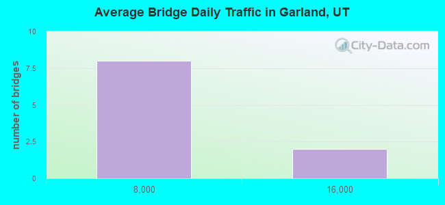
- 36,538Total average daily traffic
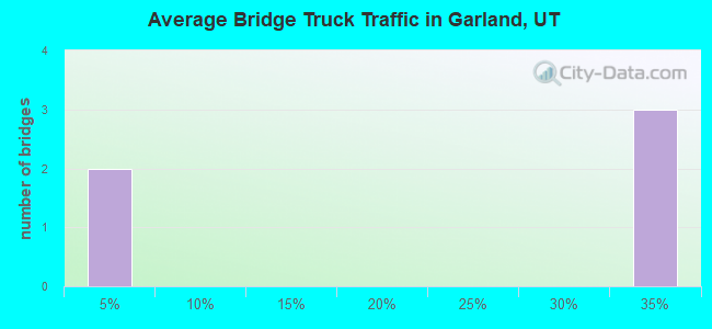
- 10,558Total average daily truck traffic
- National Bridge Inventory (NBI) Registered Bridges for Garland
- No street view available for this location
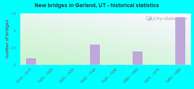
- New bridges - historical statistics
- 11910-1919
- 31940-1949
- 21960-1969
- 71980-1989
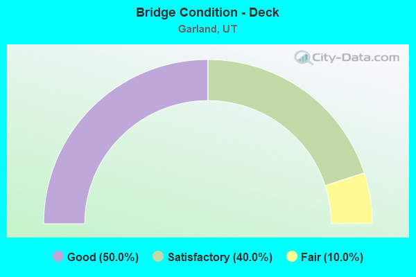
- Bridge Condition - Deck
- 50.0%Good
- 40.0%Satisfactory
- 10.0%Fair
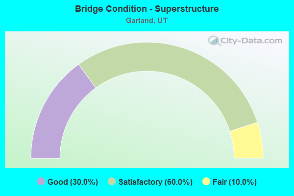
- Bridge Condition - Superstructure
- 30.0%Good
- 60.0%Satisfactory
- 10.0%Fair
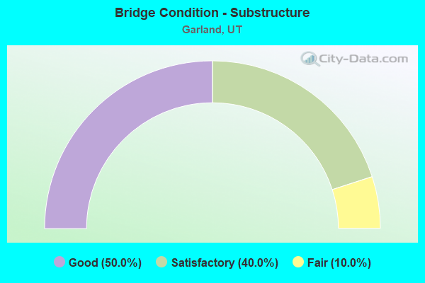
- Bridge Condition - Substructure
- 50.0%Good
- 40.0%Satisfactory
- 10.0%Fair
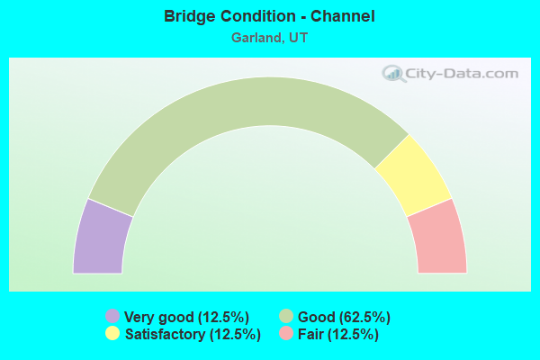
- Bridge Condition - Channel
- 12.5%Very good
- 62.5%Good
- 12.5%Satisfactory
- 12.5%Fair
Find on map >> Show street view
Structure Number: 3011F, Location: 3 MILES SW. OF RIVERSIDE (Lat: 41.755622, Lng: -112.169992), Route carried "on" structure: County highway , Year Built: 1915, Year Reconstructed: 1984, Status: Open, Structure Length: 1.56m (5.12ft), Average Daily Traffic: 190 (year 2020), Average Future Daily Traffic: 230 (year 2040), Design Load: HS 20, Features Intersected: WEST CANAL, Facility Carried by Structure: COUNTY ROAD
Minimum Vertical Clearance: 30+ m (98+ ft), Kilometerpoint: 0.984, Lanes on structure: 2, Owner: County Highway Agency, Approaching Roadway Width: 6.5m (21.3ft), Material/Design: Prestressed concrete, Design/Construction: Tee Beam, Number Of Spans In Main Unit: 1, Length of Maximum Span: 11.6m (38.1ft), Curb-To-Curb Width: 6.5m (21.3ft), Out-to-Out Width: 6.6m (21.7ft)
Condition: Deck: Satisfactory, Superstructure: Satisfactory, Substructure: Fair, Channel: Good, Operating Rating: 32.4 metric tons, Method Used To Determine Operating Rating: Load and Resistance Factor Rating (LRFR) rating reported by rating factor(RF) method using HL-93 loadings, Inventory Rating: 23.0 metric tons, Method Used To Determine Inventory Rating: Load Factor (LF) rating reported by rating factor (RF) method using MS18 loading, Structural Evaluation: Somewhat better than minimum adequacy, Deck Geometry: Meets minimum limits, Waterway Adequacy: Equal to present minimum criteria, Approach Roadway Alignment: Meets minimum limits, Designated Inspection Frequency: Every 24 months, Inspection Date: November 2021, Deck Structure Type: Concrete Cast-file-Place, Wearing Surface/Protective System: Wearing Surface: Bituminous
Find on map >> Show street view
Structure Number: 3012A, Location: 13540 N. 4400 W., GARLAND (Lat: 41.755800, Lng: -112.128206), Route carried "on" structure: County highway 1132, Year Built: 1948, Status: Posted for load, Structure Length: 1.03m (3.38ft), Average Daily Traffic: 870 (year 2020), Average Future Daily Traffic: 1,088 (year 2040), Design Load: H 15, Features Intersected: CORINNE CANAL, Facility Carried by Structure: 4400 W.ST.,FA.#506
Minimum Vertical Clearance: 30+ m (98+ ft), Kilometerpoint: 2.684, Lanes on structure: 2, Owner: County Highway Agency, Approaching Roadway Width: 7.9m (25.9ft), Skew: 1 degrees, Material/Design: Wood or Timber, Design/Construction: Stringer/Multi-beam, Number Of Spans In Main Unit: 1, Length of Maximum Span: 9.2m (30.2ft), Curb-To-Curb Width: 7.9m (25.9ft), Out-to-Out Width: 7.9m (25.9ft)
Condition: Deck: Satisfactory, Superstructure: Satisfactory, Substructure: Satisfactory, Channel: Good, Operating Rating: 7.1 metric tons, Method Used To Determine Operating Rating: Load Factor (LF) rating reported by rating factor (RF) method using MS18 loading, Inventory Rating: 1.3 metric tons, Method Used To Determine Inventory Rating: Load and Resistance Factor Rating (LRFR) rating reported by rating factor(RF) method using HL-93 loadings, Structural Evaluation: High priority of replacement, Deck Geometry: Somewhat better than minimum adequacy, Waterway Adequacy: Equal to present desirable criteria, Approach Roadway Alignment: Equal to present minimum criteria, Bridge Posting: Required (Relationship of Operating Rating to Maximum Legal Load: > 39.9% below), Designated Inspection Frequency: Every 24 months, Inspection Date: November 2021, Deck Structure Type: Wood or Timber, Wearing Surface/Protective System: Wearing Surface: Bituminous
Find on map >> Show street view
Structure Number: 3014F, Location: 5000 W. 14400 N., GARLAND (Lat: 41.770478, Lng: -112.142714), Route carried "on" structure: County highway 1138, Year Built: 1960, Status: Posted for load, Structure Length: 1.58m (5.18ft), Average Daily Traffic: 120 (year 2020), Average Future Daily Traffic: 150 (year 2040), Design Load: H 15, Features Intersected: MALAD RIVER, Facility Carried by Structure: 14400 N.ST.,CO.RD.
Minimum Vertical Clearance: 30+ m (98+ ft), Kilometerpoint: 4.955, Lanes on structure: 2, Owner: County Highway Agency, Approaching Roadway Width: 7.9m (25.9ft), Material/Design: Prestressed concrete, Design/Construction: Tee Beam, Number Of Spans In Main Unit: 1, Length of Maximum Span: 15.5m (50.9ft), Curb-To-Curb Width: 7.9m (25.9ft), Out-to-Out Width: 8.6m (28.2ft)
Condition: Deck: Good, Superstructure: Good, Substructure: Good, Channel: Good, Operating Rating: 24.6 metric tons, Method Used To Determine Operating Rating: Load and Resistance Factor Rating (LRFR) rating reported by rating factor(RF) method using HL-93 loadings, Inventory Rating: 16.5 metric tons, Method Used To Determine Inventory Rating: Load and Resistance Factor Rating (LRFR) rating reported by rating factor(RF) method using HL-93 loadings, Structural Evaluation: Somewhat better than minimum adequacy, Deck Geometry: Somewhat better than minimum adequacy, Waterway Adequacy: Somewhat better than minimum adequacy, Approach Roadway Alignment: Equal to present desirable criteria, Bridge Posting: Required (Relationship of Operating Rating to Maximum Legal Load: 10.0 - 19.9% below), Designated Inspection Frequency: Every 24 months, Inspection Date: November 2021, Deck Structure Type: Concrete Precast Panels, Wearing Surface/Protective System: Wearing Surface: Bituminous
Find on map >> Show street view
Structure Number: 3015D, Location: 14900 N. 6000 W., GARLAND (Lat: 41.779500, Lng: -112.163700), Route carried "on" structure: County highway 1135, Year Built: 1988, Status: Open, Structure Length: 0.97m (3.18ft), Average Daily Traffic: 1,100 (year 2020), Truck Traffic: 1%, Average Future Daily Traffic: 1,375 (year 2040), Design Load: HS 20, Features Intersected: WEST CANAL, Facility Carried by Structure: 6000 W.ST.,CO.RD.
Minimum Vertical Clearance: 30+ m (98+ ft), Kilometerpoint: 1.034, Lanes on structure: 2, Owner: County Highway Agency, Approaching Roadway Width: 9.1m (29.9ft), Material/Design: Concrete, Design/Construction: Frame, Number Of Spans In Main Unit: 1, Length of Maximum Span: 9.1m (29.9ft), Curb-To-Curb Width: 9.1m (29.9ft), Out-to-Out Width: 9.1m (29.9ft)
Condition: Deck: Fair, Superstructure: Fair, Substructure: Good, Channel: Satisfactory, Operating Rating: 32.4 metric tons, Method Used To Determine Operating Rating: Load and Resistance Factor Rating (LRFR) rating reported by rating factor(RF) method using HL-93 loadings, Inventory Rating: 21.1 metric tons, Method Used To Determine Inventory Rating: Load and Resistance Factor Rating (LRFR) rating reported by rating factor(RF) method using HL-93 loadings, Structural Evaluation: Somewhat better than minimum adequacy, Deck Geometry: Somewhat better than minimum adequacy, Waterway Adequacy: Equal to present minimum criteria, Approach Roadway Alignment: Equal to present desirable criteria, Designated Inspection Frequency: Every 24 months, Inspection Date: November 2021, Deck Structure Type: Concrete Precast Panels, Wearing Surface/Protective System: Wearing Surface: Bituminous
Find on map >> Show street view
Structure Number: 3044F, Location: SE. SIDE OF GARLAND (Lat: 41.726619, Lng: -112.150792), Route carried "on" structure: City street 1129, Year Built: 1965, Status: Posted for load, Structure Length: 1.55m (5.09ft), Average Daily Traffic: 2,120 (year 2020), Average Future Daily Traffic: 2,650 (year 2040), Design Load: HL 93, Features Intersected: MALAD RIVER, Facility Carried by Structure: CITY ROAD-GARLAND
Minimum Vertical Clearance: 30+ m (98+ ft), Kilometerpoint: 0.951, Lanes on structure: 2, Owner: City or Municipal Highway Agency, Approaching Roadway Width: 8.0m (26.2ft), Material/Design: Prestressed concrete, Design/Construction: Tee Beam, Number Of Spans In Main Unit: 1, Length of Maximum Span: 15.2m (49.9ft), Curb-To-Curb Width: 8.0m (26.2ft), Out-to-Out Width: 8.6m (28.2ft)
Condition: Deck: Good, Superstructure: Satisfactory, Substructure: Satisfactory, Channel: Good, Operating Rating: 34.7 metric tons, Method Used To Determine Operating Rating: Load and Resistance Factor Rating (LRFR) rating reported by rating factor(RF) method using HL-93 loadings, Inventory Rating: 24.3 metric tons, Method Used To Determine Inventory Rating: Load Factor (LF) rating reported by rating factor (RF) method using MS18 loading, Structural Evaluation: Equal to present minimum criteria, Deck Geometry: High priority of corrective action, Waterway Adequacy: Equal to present minimum criteria, Approach Roadway Alignment: Equal to present desirable criteria, Designated Inspection Frequency: Every 24 months, Inspection Date: November 2021, Deck Structure Type: Concrete Precast Panels, Wearing Surface/Protective System: Wearing Surface: Bituminous
Find on map >> Show street view
Structure Number: 3047C, Location: 6800 W. 12800 N., GARLAND (Lat: 41.740389, Lng: -112.182111), Route carried "on" structure: City street , Year Built: 1945, Status: Open, Structure Length: 1.24m (4.07ft), Average Daily Traffic: 252 (year 2020), Truck Traffic: 1%, Average Future Daily Traffic: 306 (year 2040), Design Load: HS 20+Mod, Features Intersected: WEST CANAL, Facility Carried by Structure: 12800 NORTH STREET
Minimum Vertical Clearance: 30+ m (98+ ft), Kilometerpoint: 0.000, Lanes on structure: 2, Owner: City or Municipal Highway Agency, Approaching Roadway Width: 6.2m (20.3ft), Skew: 2 degrees, Material/Design: Steel, Design/Construction: Stringer/Multi-beam, Number Of Spans In Main Unit: 1, Length of Maximum Span: 12.1m (39.7ft), Curb-To-Curb Width: 6.2m (20.3ft), Out-to-Out Width: 6.2m (20.3ft)
Condition: Deck: Satisfactory, Superstructure: Satisfactory, Substructure: Satisfactory, Channel: Good, Operating Rating: 32.4 metric tons, Method Used To Determine Operating Rating: Load Factor (LF) rating reported by rating factor (RF) method using MS18 loading, Inventory Rating: 19.4 metric tons, Method Used To Determine Inventory Rating: Load Factor (LF) rating reported by rating factor (RF) method using MS18 loading, Structural Evaluation: Somewhat better than minimum adequacy, Deck Geometry: Meets minimum limits, Waterway Adequacy: Somewhat better than minimum adequacy, Approach Roadway Alignment: Meets minimum limits, Bridge Posting: Required (Relationship of Operating Rating to Maximum Legal Load: 10.0 - 19.9% below), Designated Inspection Frequency: Every 24 months, Inspection Date: November 2021, Deck Structure Type: Wood or Timber, Wearing Surface/Protective System: Wearing Surface: Bituminous
Find on map >> Show street view
Structure Number: 3048A, Location: 5170 W. 12800 N., GARLAND (Lat: 41.741658, Lng: -112.143531), Route carried "on" structure: County highway 1132, Year Built: 1940, Status: Posted for load, Structure Length: 1.66m (5.45ft), Average Daily Traffic: 870 (year 2020), Average Future Daily Traffic: 1,088 (year 2040), Design Load: H 15, Features Intersected: MALAD RIVER
Minimum Vertical Clearance: 4.90m (16.08ft), Kilometerpoint: 0.403, Lanes on structure: 2, Owner: County Highway Agency, Approaching Roadway Width: 7.3m (24.0ft), Skew: 3 degrees, Material/Design: Wood or Timber, Design/Construction: Stringer/Multi-beam, Number Of Spans In Main Unit: 2, Length of Maximum Span: 8.0m (26.2ft), Curb-To-Curb Width: 7.3m (24.0ft), Out-to-Out Width: 9.1m (29.9ft)
Condition: Deck: Satisfactory, Superstructure: Satisfactory, Substructure: Satisfactory, Channel: Fair, Operating Rating: 27.9 metric tons, Method Used To Determine Operating Rating: Load Factor (LF) rating reported by rating factor (RF) method using MS18 loading, Inventory Rating: 20.4 metric tons, Method Used To Determine Inventory Rating: Load Factor (LF) rating reported by rating factor (RF) method using MS18 loading, Structural Evaluation: Somewhat better than minimum adequacy, Deck Geometry: Meets minimum limits, Waterway Adequacy: Somewhat better than minimum adequacy, Approach Roadway Alignment: Equal to present desirable criteria, Bridge Posting: Required (Relationship of Operating Rating to Maximum Legal Load: 10.0 - 19.9% below), Designated Inspection Frequency: Every 24 months, Inspection Date: November 2021, Deck Structure Type: Wood or Timber, Wearing Surface/Protective System: Wearing Surface: Bituminous
Find on map >> Show street view
Structure Number: F 478, Location: EAST OF GARLAND (Lat: 41.741275, Lng: -112.143664), Route carried "on" structure: State highway 13, Year Built: 1985, Status: Open, Structure Length: 6.08m (19.95ft), Average Daily Traffic: 3,110 (year 2020), Truck Traffic: 34%, Average Future Daily Traffic: 3,888 (year 2040), Design Load: HS 20+Mod, Features Intersected: MALAD RIVER & CO. ROAD
Minimum Vertical Clearance: 30+ m (98+ ft), Kilometerpoint: 35.769, Lanes on structure: 2, Lanes under structure: 2, Owner: State Highway Agency, Approaching Roadway Width: 13.1m (43.0ft), Material/Design: Prestressed concrete continuous, Design/Construction: Stringer/Multi-beam, Number Of Spans In Main Unit: 2, Length of Maximum Span: 30.0m (98.4ft), Curb-To-Curb Width: 13.1m (43.0ft), Out-to-Out Width: 14.0m (45.9ft)
Condition: Deck: Good, Superstructure: Satisfactory, Substructure: Good, Channel: Very good, Operating Rating: 44.4 metric tons, Method Used To Determine Operating Rating: Load and Resistance Factor Rating (LRFR) rating reported by rating factor(RF) method using HL-93 loadings, Inventory Rating: 22.0 metric tons, Method Used To Determine Inventory Rating: Load and Resistance Factor Rating (LRFR) rating reported by rating factor(RF) method using HL-93 loadings, Structural Evaluation: Somewhat better than minimum adequacy, Deck Geometry: Equal to present minimum criteria, Underclear: Meets minimum limits, Waterway Adequacy: Superior to present desirable criteria, Approach Roadway Alignment: Equal to present desirable criteria, Designated Inspection Frequency: Every 24 months, Inspection Date: April 2021, Deck Structure Type: Concrete Cast-file-Place, Wearing Surface/Protective System: Wearing Surface: Monolithic Concrete, Deck Protection: Epoxy Coated Reinforcing
Find on map >> Show street view
Structure Number: 1F 518, Location: 2 MI. NO. of GARLAND INT. (Lat: 41.755325, Lng: -112.181892), Route carried "on" structure: Interstate 15, Year Built: 1989, Status: Open, Structure Length: 3.75m (12.30ft), Average Daily Traffic: 13,953 (year 2020), Truck Traffic: 34%, Average Future Daily Traffic: 17,441 (year 2040), Design Load: HS 20+Mod, Features Intersected: 13600 NORTH STREET
Minimum Vertical Clearance: 30+ m (98+ ft), Kilometerpoint: 617.187, Lanes on structure: 2, Lanes under structure: 2, Base Highway Network: Yes, Owner: State Highway Agency, Approaching Roadway Width: 12.4m (40.7ft), Skew: 11 degrees, Material/Design: Prestressed concrete, Design/Construction: Stringer/Multi-beam, Number Of Spans In Main Unit: 1, Length of Maximum Span: 36.6m (120.1ft), Curb-To-Curb Width: 12.4m (40.7ft), Out-to-Out Width: 13.4m (44.0ft)
Condition: Deck: Good, Superstructure: Good, Substructure: Good, Operating Rating: 40.5 metric tons, Method Used To Determine Operating Rating: Load and Resistance Factor Rating (LRFR) rating reported by rating factor(RF) method using HL-93 loadings, Inventory Rating: 36.0 metric tons, Method Used To Determine Inventory Rating: Load and Resistance Factor Rating (LRFR) rating reported by rating factor(RF) method using HL-93 loadings, Structural Evaluation: Better than present minimum criteria, Deck Geometry: Better than present minimum criteria, Underclear: Equal to present desirable criteria, Approach Roadway Alignment: Equal to present desirable criteria, Designated Inspection Frequency: Every 24 months, Inspection Date: April 2021, Deck Structure Type: Concrete Cast-file-Place, Wearing Surface/Protective System: Wearing Surface: Epoxy Overlay, Deck Protection: Epoxy Coated Reinforcing
Find on map >> Show street view
Structure Number: 3F 518, Location: 2 MI. NO. of GARLAND INT. (Lat: 41.755781, Lng: -112.182097), Route carried "on" structure: Interstate 15, Year Built: 1989, Status: Open, Structure Length: 3.44m (11.29ft), Average Daily Traffic: 13,953 (year 2020), Truck Traffic: 34%, Average Future Daily Traffic: 17,441 (year 2040), Design Load: HS 20+Mod, Features Intersected: 13600 NORTH ST.
Minimum Vertical Clearance: 30+ m (98+ ft), Kilometerpoint: 617.467, Lanes on structure: 2, Lanes under structure: 2, Base Highway Network: Yes, Owner: State Highway Agency, Approaching Roadway Width: 12.4m (40.7ft), Skew: 11 degrees, Material/Design: Prestressed concrete, Design/Construction: Stringer/Multi-beam, Number Of Spans In Main Unit: 1, Length of Maximum Span: 33.5m (109.9ft), Curb-To-Curb Width: 12.4m (40.7ft), Out-to-Out Width: 13.4m (44.0ft)
Condition: Deck: Good, Superstructure: Good, Substructure: Good, Operating Rating: 46.3 metric tons, Method Used To Determine Operating Rating: Load and Resistance Factor Rating (LRFR) rating reported by rating factor(RF) method using HL-93 loadings, Inventory Rating: 36.9 metric tons, Method Used To Determine Inventory Rating: Load and Resistance Factor Rating (LRFR) rating reported by rating factor(RF) method using HL-93 loadings, Structural Evaluation: Better than present minimum criteria, Deck Geometry: Better than present minimum criteria, Underclear: Equal to present desirable criteria, Approach Roadway Alignment: Equal to present desirable criteria, Designated Inspection Frequency: Every 24 months, Inspection Date: April 2021, Deck Structure Type: Concrete Cast-file-Place, Wearing Surface/Protective System: Wearing Surface: Epoxy Overlay, Deck Protection: Epoxy Coated Reinforcing
Find on map >> Show street view
Structure Number: F 478, Location: EAST OF GARLAND (Lat: 41.741275, Lng: -112.143664), Route carried "under" structure: County highway , Year Built: 1985, Structure Length: 0. m, Features Intersected: MALAD RIVER & CO. ROAD, Facility Carried by Structure: SR-13
Minimum Vertical Clearance: 4.90m (16.08ft), Kilometerpoint: 0.000, Lanes on structure: 2, Lanes under structure: 2, Material/Design: Prestressed concrete continuous, Design/Construction: Stringer/Multi-beam, Length of Maximum Span: 30.0m (98.4ft)
Find on map >> Show street view
Structure Number: 1F 518, Location: 2 MI. NO. of GARLAND INT. (Lat: 41.755325, Lng: -112.181892), Route carried "under" structure: County highway , Year Built: 1989, Structure Length: 0. m, Features Intersected: 13600 NORTH STREET, Facility Carried by Structure: I-15NB, (SR-15)
Minimum Vertical Clearance: 6.27m (20.57ft), Kilometerpoint: 0.000, Lanes on structure: 2, Lanes under structure: 2, Material/Design: Prestressed concrete, Design/Construction: Stringer/Multi-beam, Length of Maximum Span: 36.6m (120.1ft)
Find on map >> Show street view
Structure Number: 3F 518, Location: 2 MI. NO. of GARLAND INT. (Lat: 41.755781, Lng: -112.182097), Route carried "under" structure: County highway , Year Built: 1989, Structure Length: 0. m, Features Intersected: 13600 NORTH ST., Facility Carried by Structure: I-15 (SR-15) SB
Minimum Vertical Clearance: 5.23m (17.16ft), Kilometerpoint: 0.000, Lanes on structure: 2, Lanes under structure: 2, Material/Design: Prestressed concrete, Design/Construction: Stringer/Multi-beam, Length of Maximum Span: 33.5m (109.9ft)