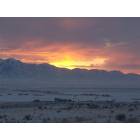
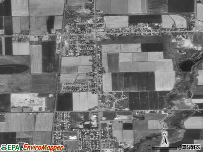
Garland, Utah
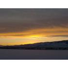
Garland: sunrise in garland utah
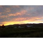
Garland: walkin fair lambs while watchin the sunset over BR mountain
Garland: sunsetting on the town of garland utah
- add
your
Submit your own pictures of this city and show them to the world
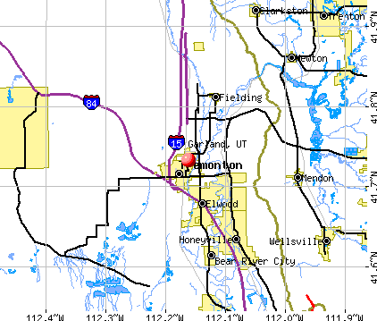
- OSM Map
- General Map
- Google Map
- MSN Map
Population change since 2000: +34.5%
| Males: 1,172 | |
| Females: 1,441 |
| Median resident age: | 29.4 years |
| Utah median age: | 32.1 years |
Zip codes: 84312.
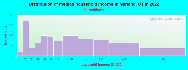
| Garland: | $57,847 |
| UT: | $89,168 |
Estimated per capita income in 2022: $28,807 (it was $13,408 in 2000)
Garland city income, earnings, and wages data
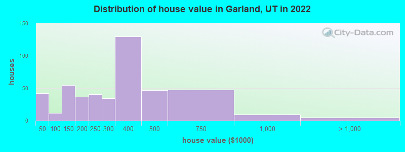
Estimated median house or condo value in 2022: $323,299 (it was $100,800 in 2000)
| Garland: | $323,299 |
| UT: | $499,500 |
Mean prices in 2022: all housing units: $287,843; detached houses: $279,944; townhouses or other attached units: $394,910
Median gross rent in 2022: $827.
(7.9% for White Non-Hispanic residents, 37.9% for Hispanic or Latino residents, 18.8% for American Indian residents, 87.7% for other race residents, 27.7% for two or more races residents)
Detailed information about poverty and poor residents in Garland, UT
Compare current foreclosures near Garland, UT:
| Photo | Address | Area | Beds / Baths | Price | Details |
|---|---|---|---|---|---|

|
#1
W 19200 N # 55
Garland, UT 84312
|
- sq. feet
|
- baths - beds |
show details | |

|
#2
E Poplar Ct
Garland, UT 84312
|
1,932 sq. feet
|
- baths - beds |
show details | |

|
#3
N 100 W
Garland, UT 84312
|
1,589 sq. feet
|
- baths - beds |
show details | |

|
#4
W 780 S
Garland, UT 84312
|
1,518 sq. feet
|
- baths - beds |
show details | |

|
#5
Willow Ln
Garland, UT 84312
|
998 sq. feet
|
- baths - beds |
show details | |

|
#6
North 5600 West, Lot 45
Garland, UT 84312
|
- sq. feet
|
- baths - beds |
show details | |

|
#7
E Factory St Apt 15
Garland, UT 84312
|
- sq. feet
|
- baths - beds |
show details | |

|
#8
W 450 N # 4
Tremonton, UT 84337
|
1,004 sq. feet
|
1 baths 2 beds |
$255,000
|
show details |

|
#9
E Factory St
Garland, UT 84312
|
- sq. feet
|
- baths - beds |
show details | |

|
#10
W 275 S
Tremonton, UT 84337
|
- sq. feet
|
2 baths 5 beds |
show details |
| Photo | Address | Area | Beds / Baths | Price | Details |
|---|---|---|---|---|---|

|
#11
W 1100 N
Tremonton, UT 84337
|
1,701 sq. feet
|
2 baths 3 beds |
show details | |

|
#12
S 200 E
Clarkston, UT 84305
|
1,476 sq. feet
|
- baths - beds |
show details | |

|
#13
W 500 N
Brigham City, UT 84302
|
1,107 sq. feet
|
- baths - beds |
show details | |

|
#14
W 1100 N
Logan, UT 84341
|
- sq. feet
|
- baths - beds |
show details | |

|
#15
W 1000 N
Logan, UT 84321
|
- sq. feet
|
- baths - beds |
show details | |

|
#16
N Main St # 7
Brigham City, UT 84302
|
- sq. feet
|
- baths - beds |
show details | |

|
#17
E 600 N
Brigham City, UT 84302
|
1,083 sq. feet
|
- baths - beds |
show details | |

|
#18
W 100 N
Logan, UT 84321
|
- sq. feet
|
- baths - beds |
show details | |

|
#19
Kingston Pl
Brigham City, UT 84302
|
1,240 sq. feet
|
- baths - beds |
show details | |

|
#20
W 400 N
Brigham City, UT 84302
|
1,340 sq. feet
|
- baths - beds |
show details |
| Photo | Address | Area | Beds / Baths | Price | Details |
|---|---|---|---|---|---|

|
#21
N 100 E, Apt 3
Brigham City, UT 84302
|
- sq. feet
|
- baths - beds |
show details | |

|
#22
W 1800 N Apt A104
Logan, UT 84341
|
- sq. feet
|
- baths - beds |
show details | |

|
#23
W Highway 101
Hyrum, UT 84319
|
- sq. feet
|
- baths - beds |
show details | |

|
#24
N 400 W Apt F303
Logan, UT 84341
|
- sq. feet
|
- baths - beds |
show details | |

|
#25
W 725 N
Logan, UT 84321
|
- sq. feet
|
- baths - beds |
show details | |

|
#26
S 400 W # 1
Logan, UT 84321
|
- sq. feet
|
- baths - beds |
show details | |

|
#27
N 500 W
Hyrum, UT 84319
|
- sq. feet
|
- baths - beds |
show details | |

|
#28
W 200 N
Logan, UT 84321
|
- sq. feet
|
- baths - beds |
show details | |

|
#29
W 725 N
Logan, UT 84321
|
- sq. feet
|
- baths - beds |
show details | |

|
#30
S 500 W, Apt 1
Logan, UT 84321
|
- sq. feet
|
- baths - beds |
show details |
| Photo | Address | Area | Beds / Baths | Price | Details |
|---|---|---|---|---|---|

|
#31
N Main St Apt 12
Brigham City, UT 84302
|
- sq. feet
|
- baths - beds |
show details | |

|
#32
N 480 W
Logan, UT 84321
|
- sq. feet
|
- baths - beds |
show details | |

|
#33
E 700 N
Brigham City, UT 84302
|
925 sq. feet
|
- baths - beds |
show details | |

|
#34
W 600 N
Logan, UT 84321
|
- sq. feet
|
- baths - beds |
show details | |

|
#35
N 100 W, Apt 4
Logan, UT 84321
|
- sq. feet
|
- baths - beds |
show details | |

|
#36
N 100 E
Logan, UT 84321
|
- sq. feet
|
- baths - beds |
show details | |

|
#37
N 300 W
Brigham City, UT 84302
|
- sq. feet
|
- baths - beds |
show details | |

|
#38
E 300 N
Brigham City, UT 84302
|
2,018 sq. feet
|
- baths - beds |
show details | |

|
#39
N 500 W
Brigham City, UT 84302
|
900 sq. feet
|
- baths - beds |
show details | |

|
#40
N 120 W, Apt 4
Logan, UT 84341
|
- sq. feet
|
- baths - beds |
show details |
| Photo | Address | Area | Beds / Baths | Price | Details |
|---|---|---|---|---|---|

|
#41
W 3200 S
Logan, UT 84321
|
- sq. feet
|
- baths - beds |
show details | |

|
#42
W 1600 N Apt E101
Logan, UT 84341
|
- sq. feet
|
- baths - beds |
show details | |

|
#43
N 150 W
Logan, UT 84321
|
- sq. feet
|
- baths - beds |
show details | |

|
#44
W 1190 N
Logan, UT 84341
|
- sq. feet
|
- baths - beds |
show details | |

|
#45
E 400 N
Brigham City, UT 84302
|
1,104 sq. feet
|
- baths - beds |
show details | |

|
#46
N 400 W, Apt N
Logan, UT 84341
|
- sq. feet
|
- baths - beds |
show details | |

|
#47
W 400 N
Logan, UT 84321
|
- sq. feet
|
- baths - beds |
show details | |

|
#48
N 400 W
Hyrum, UT 84319
|
- sq. feet
|
- baths - beds |
show details | |

|
#49
N 400 W
Brigham City, UT 84302
|
841 sq. feet
|
- baths - beds |
show details | |

|
Check over 1 million property listings on Foreclosure.com!
|
browse all offers | |||


- 2,05877.5%White alone
- 54720.6%Hispanic
- 160.6%Two or more races
- 120.5%American Indian alone
- 80.3%Asian alone
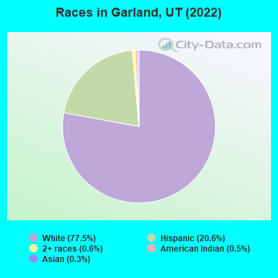
Races in Garland detailed stats: ancestries, foreign born residents, place of birth
According to our research of Utah and other state lists, there were 16 registered sex offenders living in Garland, Utah as of April 27, 2024.
The ratio of all residents to sex offenders in Garland is 158 to 1.
 Recent articles from our blog. Our writers, many of them Ph.D. graduates or candidates, create easy-to-read articles on a wide variety of topics.

 | Inconsiderate drivers! (98 replies) |
Latest news from Garland, UT collected exclusively by city-data.com from local newspapers, TV, and radio stations
Ancestries: English (21.4%), American (19.4%), German (9.2%), European (5.9%), Danish (2.5%), Swedish (2.5%).
Current Local Time: MST time zone
Elevation: 4344 feet
Land area: 1.77 square miles.
Population density: 1,476 people per square mile (low).
21 residents are foreign born
| This city: | 0.8% |
| Utah: | 8.4% |
Median real estate property taxes paid for housing units with mortgages in 2022: $1,760 (0.5%)
Median real estate property taxes paid for housing units with no mortgage in 2022: $1,330 (0.5%)
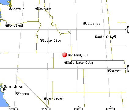
Nearest city with pop. 50,000+: Ogden, UT  (36.5 miles , pop. 77,226).
Nearest city with pop. 200,000+: Northeast Jefferson, CO (394.3 miles , pop. 450,166).
Nearest city with pop. 1,000,000+: Phoenix, AZ (567.5 miles , pop. 1,321,045).
Nearest cities:
), ), ), ), ), ), Latitude: 41.73 N, Longitude: 112.16 W
Area code commonly used in this area: 435
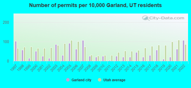
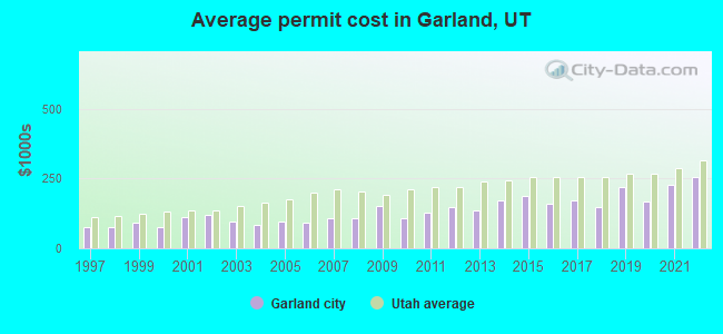
Single-family new house construction building permits:
- 2022: 21 buildings, average cost: $257,000
- 2021: 12 buildings, average cost: $229,100
- 2020: 4 buildings, average cost: $168,100
- 2019: 2 buildings, average cost: $221,000
- 2018: 11 buildings, average cost: $146,400
- 2017: 6 buildings, average cost: $171,000
- 2016: 4 buildings, average cost: $160,900
- 2015: 9 buildings, average cost: $186,800
- 2014: 4 buildings, average cost: $170,300
- 2013: 4 buildings, average cost: $135,800
- 2012: 5 buildings, average cost: $145,700
- 2011: 1 building, cost: $125,600
- 2010: 5 buildings, average cost: $108,800
- 2009: 4 buildings, average cost: $151,200
- 2008: 5 buildings, average cost: $108,000
- 2007: 21 buildings, average cost: $107,800
- 2006: 12 buildings, average cost: $91,100
- 2005: 18 buildings, average cost: $95,700
- 2004: 6 buildings, average cost: $83,700
- 2003: 17 buildings, average cost: $96,900
- 2002: 3 buildings, average cost: $120,000
- 2001: 5 buildings, average cost: $110,000
- 2000: 10 buildings, average cost: $73,900
- 1999: 3 buildings, average cost: $90,300
- 1998: 11 buildings, average cost: $76,700
- 1997: 20 buildings, average cost: $73,600
| Here: | 2.3% |
| Utah: | 2.5% |
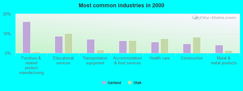
- Furniture & related product manufacturing (16.1%)
- Educational services (8.7%)
- Transportation equipment (7.2%)
- Accommodation & food services (6.4%)
- Health care (5.7%)
- Construction (4.9%)
- Metal & metal products (4.2%)
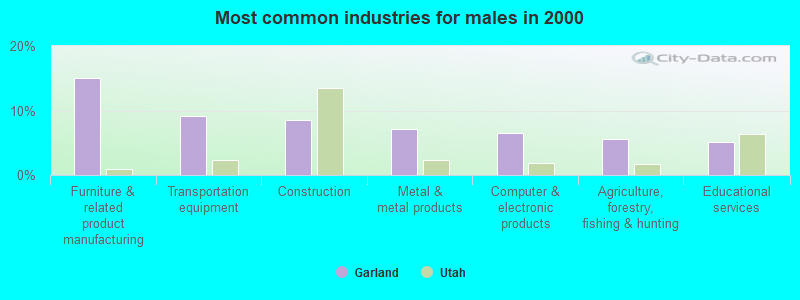
- Furniture & related product manufacturing (15.1%)
- Transportation equipment (9.2%)
- Construction (8.5%)
- Metal & metal products (7.2%)
- Computer & electronic products (6.5%)
- Agriculture, forestry, fishing & hunting (5.6%)
- Educational services (5.2%)
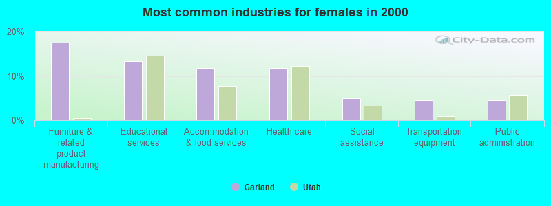
- Furniture & related product manufacturing (17.5%)
- Educational services (13.3%)
- Accommodation & food services (11.8%)
- Health care (11.8%)
- Social assistance (5.0%)
- Transportation equipment (4.4%)
- Public administration (4.4%)
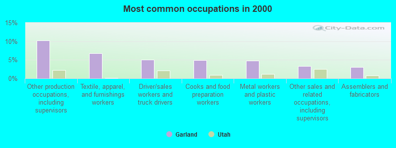
- Other production occupations, including supervisors (10.2%)
- Textile, apparel, and furnishings workers (6.8%)
- Driver/sales workers and truck drivers (5.0%)
- Cooks and food preparation workers (4.9%)
- Metal workers and plastic workers (4.7%)
- Other sales and related occupations, including supervisors (3.3%)
- Assemblers and fabricators (3.1%)
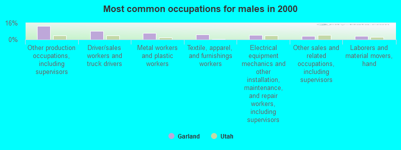
- Other production occupations, including supervisors (13.0%)
- Driver/sales workers and truck drivers (8.3%)
- Metal workers and plastic workers (6.5%)
- Textile, apparel, and furnishings workers (4.9%)
- Electrical equipment mechanics and other installation, maintenance, and repair workers, including supervisors (4.3%)
- Other sales and related occupations, including supervisors (3.6%)
- Laborers and material movers, hand (3.6%)
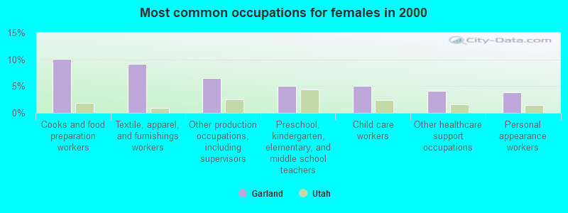
- Cooks and food preparation workers (10.1%)
- Textile, apparel, and furnishings workers (9.2%)
- Other production occupations, including supervisors (6.5%)
- Preschool, kindergarten, elementary, and middle school teachers (5.0%)
- Child care workers (5.0%)
- Other healthcare support occupations (4.1%)
- Personal appearance workers (3.8%)
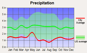
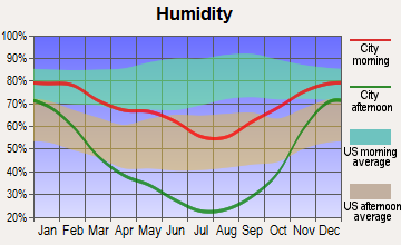
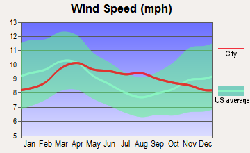
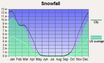
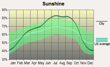
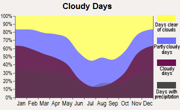
Average climate in Garland, Utah
Based on data reported by over 4,000 weather stations

|
|


(lower is better)
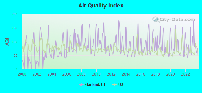
Air Quality Index (AQI) level in 2023 was 86.6. This is about average.
| City: | 86.6 |
| U.S.: | 72.6 |
Nitrogen Dioxide (NO2) [ppb] level in 2023 was 2.69. This is significantly better than average. Closest monitor was 4.1 miles away from the city center.
| City: | 2.69 |
| U.S.: | 5.11 |
Sulfur Dioxide (SO2) [ppb] level in 2005 was 1.02. This is significantly better than average. Closest monitor was 4.1 miles away from the city center.
| City: | 1.02 |
| U.S.: | 1.51 |
Ozone [ppb] level in 2023 was 37.8. This is about average. Closest monitor was 15.2 miles away from the city center.
| City: | 37.8 |
| U.S.: | 33.3 |
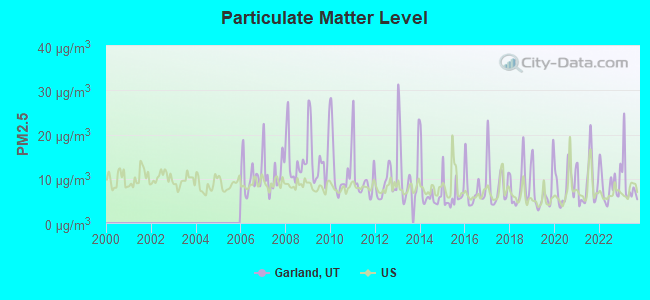
Particulate Matter (PM2.5) [µg/m3] level in 2023 was 9.08. This is about average. Closest monitor was 4.1 miles away from the city center.
| City: | 9.08 |
| U.S.: | 8.11 |
Earthquake activity:
Garland-area historical earthquake activity is significantly above Utah state average. It is 2049% greater than the overall U.S. average.On 8/18/1959 at 06:37:13, a magnitude 7.7 (7.7 UK, Class: Major, Intensity: VIII - XII) earthquake occurred 210.2 miles away from the city center, causing $26,000,000 total damage
On 10/28/1983 at 14:06:06, a magnitude 7.3 (6.2 MB, 7.3 MS, 7.0 MW) earthquake occurred 182.2 miles away from Garland center, causing 2 deaths (2 shaking deaths) and 3 injuries, causing $15,000,000 total damage
On 10/3/1915 at 06:52:48, a magnitude 7.6 (7.6 UK) earthquake occurred 290.9 miles away from the city center
On 3/28/1975 at 02:31:05, a magnitude 6.2 (6.1 MB, 6.0 MS, 6.2 ML, Class: Strong, Intensity: VII - IX) earthquake occurred 25.2 miles away from the city center
On 3/31/2020 at 23:52:30, a magnitude 6.5 (6.5 MW, Depth: 7.5 mi) earthquake occurred 240.8 miles away from Garland center
On 3/18/2020 at 13:09:31, a magnitude 5.7 (5.7 MW, Depth: 7.4 mi, Class: Moderate, Intensity: VI - VII) earthquake occurred 68.1 miles away from Garland center
Magnitude types: body-wave magnitude (MB), local magnitude (ML), surface-wave magnitude (MS), moment magnitude (MW)
Natural disasters:
The number of natural disasters in Box Elder County (8) is smaller than the US average (15).Major Disasters (Presidential) Declared: 4
Emergencies Declared: 2
Causes of natural disasters: Floods: 5, Landslides: 3, Storms: 2, Drought: 1, Hurricane: 1, Mudslide: 1, Winter Storm: 1, Other: 1 (Note: some incidents may be assigned to more than one category).
Colleges/universities with over 2000 students nearest to Garland:
- Utah State University (about 18 miles; Logan, UT; Full-time enrollment: 21,131)
- Weber State University (about 40 miles; Ogden, UT; FT enrollment: 17,655)
- Latter-day Saints Business College (about 68 miles; Salt Lake City, UT; FT enrollment: 2,059)
- University of Utah (about 70 miles; Salt Lake City, UT; FT enrollment: 28,454)
- Westminster College (about 72 miles; Salt Lake City, UT; FT enrollment: 2,870)
- Western Governors University (about 75 miles; Salt Lake City, UT; FT enrollment: 31,481)
- Salt Lake Community College (about 75 miles; Salt Lake City, UT; FT enrollment: 20,797)
Public high schools in Garland:
- BEAR RIVER HIGH (Students: 900, Location: 1450 S MAIN, Grades: 10-12)
- BEAR RIVER MIDDLE (Students: 627, Location: 300 E 1500 S, Grades: 8-9)
Private high school in Garland:
Public elementary/middle school in Garland:
- GARLAND SCHOOL (Students: 421, Location: 450 S. 100 W., Grades: KG-5)
Points of interest:
Notable location: Garland Fire Department (A). Display/hide its location on the map
Church in Garland: The Church of Jesus Christ of Latter Day Saints (A). Display/hide its location on the map
Birthplace of: Chris Huber - College basketball player (Utah State Aggies), Jay Van Noy - Baseball player.
Drinking water stations with addresses in Garland and their reported violations in the past:
GARLAND CITY WATER SYSTEM (Population served: 1,943, Groundwater):Past monitoring violations:UKON WATER COMPANY (Population served: 1,128, Groundwater):
- Monitoring, Source Water (GWR) - In FEB-01-2012, Contaminant: E. COLI. Follow-up actions: St Formal NOV issued (MAR-30-2012), St Public Notif requested (MAR-30-2012)
- Monitoring, Repeat Major (TCR) - In JAN-2012, Contaminant: Coliform (TCR). Follow-up actions: St Formal NOV issued (MAR-16-2012), St Public Notif requested (MAR-16-2012)
- One minor monitoring violation
- One regular monitoring violation
Past health violations:RIVERSIDE-NORTH GARLAND WATER CO (Population served: 750, Groundwater):Past monitoring violations:
- MCL, Average - Between OCT-2011 and SEP-2012, Contaminant: Arsenic. Follow-up actions: St Public Notif requested (DEC-17-2012), St Formal NOV issued (DEC-17-2012), St AO (w/o penalty) issued (JAN-16-2014)
- MCL, Average - Between OCT-2011 and SEP-2012, Contaminant: Arsenic. Follow-up actions: St Public Notif requested (DEC-17-2012), St Formal NOV issued (DEC-17-2012), St AO (w/o penalty) issued (JAN-16-2014)
- MCL, Average - Between OCT-2011 and SEP-2012, Contaminant: Arsenic. Follow-up actions: St Public Notif requested (DEC-17-2012), St Formal NOV issued (DEC-17-2012), St AO (w/o penalty) issued (JAN-16-2014)
- MCL, Average - Between OCT-2011 and SEP-2012, Contaminant: Arsenic. Follow-up actions: St Public Notif requested (DEC-17-2012), St Formal NOV issued (DEC-17-2012), St AO (w/o penalty) issued (JAN-16-2014)
- One minor monitoring violation
- 21 regular monitoring violations
Past monitoring violations:
- Monitoring, Repeat Major (TCR) - In JUL-2011, Contaminant: Coliform (TCR)
- Follow-up Or Routine LCR Tap M/R - In OCT-01-2007, Contaminant: Lead and Copper Rule. Follow-up actions: St Compliance achieved (FEB-10-2011)
- Follow-up Or Routine LCR Tap M/R - In JAN-01-2003, Contaminant: Lead and Copper Rule. Follow-up actions: St Compliance achieved (FEB-25-2008)
- One minor monitoring violation
- 23 regular monitoring violations
| This city: | 3.3 people |
| Utah: | 3.1 people |
| This city: | 80.5% |
| Whole state: | 75.2% |
| This city: | 4.8% |
| Whole state: | 4.6% |
Likely homosexual households (counted as self-reported same-sex unmarried-partner households)
- Lesbian couples: 0.1% of all households
- Gay men: 0.1% of all households
For population 15 years and over in Garland:
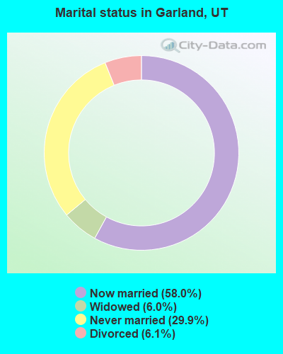
- Never married: 29.9%
- Now married: 58.0%
- Separated: 0.0%
- Widowed: 6.0%
- Divorced: 6.1%
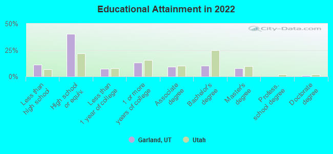
For population 25 years and over in Garland:
- High school or higher: 88.0%
- Bachelor's degree or higher: 17.6%
- Graduate or professional degree: 8.0%
- Unemployed: 4.9%
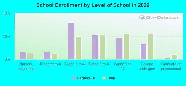
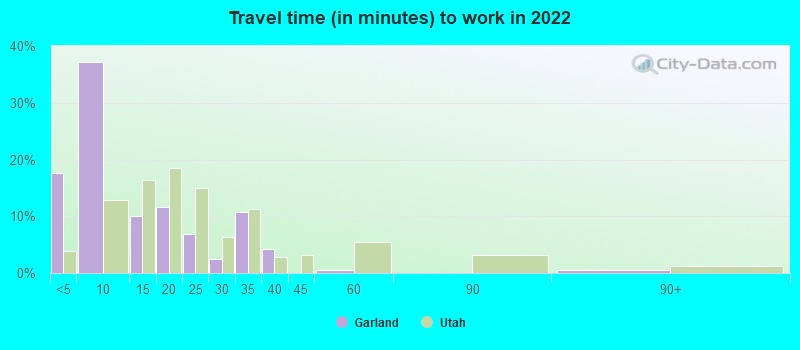
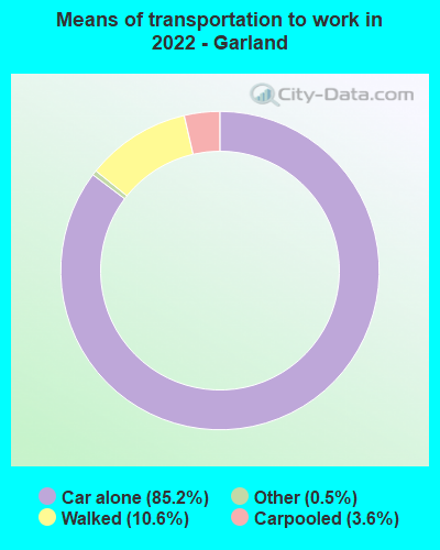
- Mean travel time to work (commute): 25.6 minutes
| Here: | 9.8 |
| Utah average: | 10.9 |
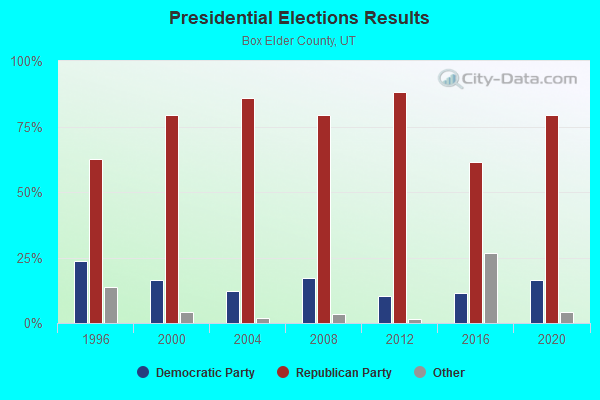
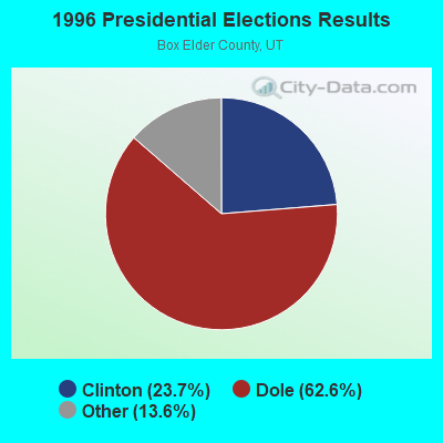
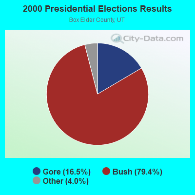
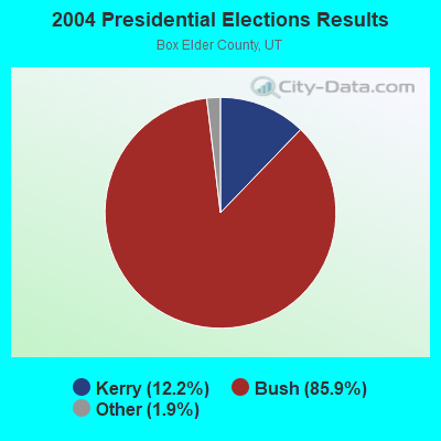
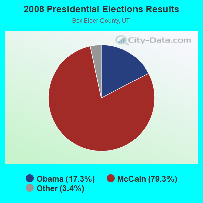
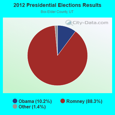
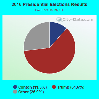

Graphs represent county-level data. Detailed 2008 Election Results
Religion statistics for Garland, UT (based on Box Elder County data)
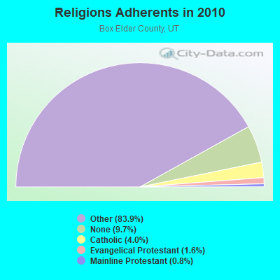
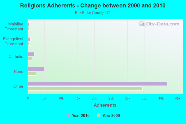
| Religion | Adherents | Congregations |
|---|---|---|
| Other | 41,921 | 105 |
| Catholic | 2,008 | 2 |
| Evangelical Protestant | 807 | 10 |
| Mainline Protestant | 389 | 3 |
| None | 4,850 | - |
Food Environment Statistics:
| Box Elder County: | 0.84 / 10,000 pop. |
| Utah: | 1.37 / 10,000 pop. |
| This county: | 0.21 / 10,000 pop. |
| Utah: | 0.18 / 10,000 pop. |
| Box Elder County: | 0.42 / 10,000 pop. |
| State: | 0.41 / 10,000 pop. |
| This county: | 3.14 / 10,000 pop. |
| State: | 2.82 / 10,000 pop. |
| This county: | 3.14 / 10,000 pop. |
| Utah: | 5.09 / 10,000 pop. |
| This county: | 6.1% |
| Utah: | 6.3% |
| Box Elder County: | 27.6% |
| Utah: | 23.6% |
Health and Nutrition:
| This city: | 47.8% |
| State: | 48.9% |
| Garland: | 44.6% |
| Utah: | 47.0% |
| Garland: | 29.1 |
| State: | 28.4 |
| This city: | 22.5% |
| Utah: | 21.0% |
| This city: | 12.8% |
| Utah: | 10.3% |
| Here: | 6.8 |
| State: | 6.8 |
| This city: | 33.3% |
| Utah: | 31.9% |
| This city: | 55.8% |
| Utah: | 57.4% |
| Here: | 78.5% |
| State: | 80.1% |
More about Health and Nutrition of Garland, UT Residents
| Local government employment and payroll (March 2022) | |||||
| Function | Full-time employees | Monthly full-time payroll | Average yearly full-time wage | Part-time employees | Monthly part-time payroll |
|---|---|---|---|---|---|
| Police Protection - Officers | 4 | $19,492 | $58,476 | 0 | $0 |
| Financial Administration | 1 | $1,365 | $16,380 | 0 | $0 |
| Other Government Administration | 1 | $4,127 | $49,524 | 5 | $238 |
| Sewerage | 1 | $2,396 | $28,752 | 0 | $0 |
| Local Libraries | 0 | $0 | 4 | $1,977 | |
| Judicial and Legal | 0 | $0 | 3 | $4,548 | |
| Police - Other | 0 | $0 | 4 | $796 | |
| Water Supply | 0 | $0 | 2 | $1,313 | |
| Other and Unallocable | 0 | $0 | 1 | $319 | |
| Parks and Recreation | 0 | $0 | 1 | $529 | |
| Totals for Government | 7 | $27,381 | $46,939 | 20 | $9,720 |
Garland government finances - Expenditure in 2017 (per resident):
- Construction - Central Staff Services: $54,000 ($20.67)
Housing and Community Development: $14,000 ($5.36)
Local Fire Protection: $11,000 ($4.21)
Libraries: $7,000 ($2.68)
- Current Operations - Police Protection: $436,000 ($166.86)
Water Utilities: $225,000 ($86.11)
Parks and Recreation: $157,000 ($60.08)
Regular Highways: $149,000 ($57.02)
Central Staff Services: $143,000 ($54.73)
Sewerage: $85,000 ($32.53)
Solid Waste Management: $83,000 ($31.76)
Local Fire Protection: $78,000 ($29.85)
Libraries: $70,000 ($26.79)
Judicial and Legal Services: $58,000 ($22.20)
Financial Administration: $18,000 ($6.89)
Housing and Community Development: $14,000 ($5.36)
Health - Other: $3,000 ($1.15)
- General - Interest on Debt: $15,000 ($5.74)
- Total Salaries and Wages: $565,000 ($216.23)
- Water Utilities - Interest on Debt: $11,000 ($4.21)
Garland government finances - Revenue in 2017 (per resident):
- Charges - Sewerage: $340,000 ($130.12)
Parks and Recreation: $104,000 ($39.80)
Solid Waste Management: $94,000 ($35.97)
Other: $79,000 ($30.23)
Housing and Community Development: $50,000 ($19.14)
- Federal Intergovernmental - Sewerage: $103,000 ($39.42)
Other: $82,000 ($31.38)
- Miscellaneous - Fines and Forfeits: $34,000 ($13.01)
General Revenue - Other: $18,000 ($6.89)
Donations From Private Sources: $12,000 ($4.59)
Interest Earnings: $10,000 ($3.83)
Sale of Property: $5,000 ($1.91)
- Revenue - Water Utilities: $307,000 ($117.49)
- State Intergovernmental - Highways: $114,000 ($43.63)
Other: $17,000 ($6.51)
General Local Government Support: $2,000 ($0.77)
- Tax - Property: $434,000 ($166.09)
General Sales and Gross Receipts: $275,000 ($105.24)
Other License: $8,000 ($3.06)
Public Utilities Sales: $4,000 ($1.53)
Occupation and Business License - Other: $2,000 ($0.77)
Garland government finances - Debt in 2017 (per resident):
- Long Term Debt - Beginning Outstanding - Unspecified Public Purpose: $764,000 ($292.38)
Outstanding Unspecified Public Purpose: $700,000 ($267.89)
Retired Unspecified Public Purpose: $64,000 ($24.49)
Garland government finances - Cash and Securities in 2017 (per resident):
- Other Funds - Cash and Securities: $360,000 ($137.77)
Strongest AM radio stations in Garland:
- KVNU (610 AM; 5 kW; LOGAN, UT; Owner: SUN VALLEY RADIO,INC.)
- KSOS (800 AM; 10 kW; BRIGHAM CITY, UT; Owner: SIMMONS-SLC, LS, LLC)
- KALL (700 AM; 50 kW; NORTH SALT LAKE CITY, UT; Owner: CITICASTERS LICENSES, L.P.)
- KLGN (1390 AM; 5 kW; LOGAN, UT; Owner: SUN VALLEY RADIO, INC.)
- KIQN (1010 AM; 50 kW; TOOELE, UT)
- KSL (1160 AM; 50 kW; SALT LAKE CITY, UT; Owner: BONNEVILLE HOLDING COMPANY)
- KXOL (1660 AM; 10 kW; BRIGHAM CITY, UT; Owner: SIMMONS-SLC, LS, LLC)
- KANN (1120 AM; 10 kW; ROY, UT; Owner: FAITH COMMUNICATIONS CORPORATION)
- KLO (1430 AM; 10 kW; OGDEN, UT; Owner: KLO BROADCASTING CO.)
- KTKK (630 AM; 10 kW; SANDY, UT; Owner: UNITED BROADCASTING COMPANY)
- KBEE (860 AM; 10 kW; SALT LAKE CITY, UT; Owner: CITADEL BROADCASTING COMPANY)
- KZNS (1280 AM; 10 kW; SALT LAKE CITY, UT; Owner: SIMMONS-SLC, LS, LLC)
- KNRS (570 AM; 5 kW; SALT LAKE CITY, UT; Owner: CITICASTERS LICENSES, L.P.)
Strongest FM radio stations in Garland:
- KRAR (106.9 FM; BRIGHAM CITY, UT; Owner: MERCURY BROADCASTING COMPANY, INC.)
- KJQN (100.7 FM; BRIGHAM CITY, UT; Owner: SIMMONS-SLC, LS, LLC)
- KBNZ (104.9 FM; TREMONTON, UT; Owner: 3 POINT MEDIA - UTAH, LLC)
- KUSU-FM (91.5 FM; LOGAN, UT; Owner: UTAH STATE UNIV. OF AGRI. & APP. SCI)
- K220HI (91.9 FM; CLARKSTON, UT; Owner: CALVARY CHAPEL OF TWIN FALLS, INC.)
- KVFX (94.5 FM; LOGAN, UT; Owner: SUN VALLEY RADIO,INC.)
- KYFO-FM (95.5 FM; OGDEN, UT; Owner: BIBLE BROADCASTING NETWORK, INC.)
- KUDD (107.9 FM; ROY, UT; Owner: MILLCREEK BROADCASTING, L.L.C.)
- KLZX (95.9 FM; WESTON, ID; Owner: SUN VALLEY RADIO INC)
- KCPX (105.7 FM; CENTERVILLE, UT; Owner: MERCURY BROADCASTING COMPANY, INC.)
- KSOP-FM (104.3 FM; SALT LAKE CITY, UT; Owner: KSOP, INC.)
- K272DP (102.3 FM; TOOELE, UT; Owner: FAMILY STATIONS, INC.)
- KBZN (97.9 FM; OGDEN, UT; Owner: CAPITOL BROADCASTING, INC.)
- KRCL (90.9 FM; SALT LAKE CITY, UT; Owner: LISTENERS COMMUNITY RADIO OF UTAH)
- KBER (101.1 FM; OGDEN, UT; Owner: CITADEL BROADCASTING COMPANY)
- KISN-FM (97.1 FM; SALT LAKE CITY, UT; Owner: CLEAR CHANNEL BROADCASTING LICENSES, INC.)
- KKAT (101.9 FM; OGDEN, UT; Owner: CITICASTERS LICENSES, L.P.)
- KSFI (100.3 FM; SALT LAKE CITY, UT; Owner: SIMMONS-SLC, LS, LLC)
- KUBL-FM (93.3 FM; SALT LAKE CITY, UT; Owner: CITADEL BROADCASTING COMPANY)
- KOSY-FM (106.5 FM; SPANISH FORK, UT; Owner: MERCURY BROADCASTING COMPANY, INC.)
TV broadcast stations around Garland:
- KUTH (Channel 12; LOGAN, UT; Owner: LOGAN 12, INC.)
- K59BV (Channel 59; LAVA HOT SPRINGS, ID; Owner: STATE BOARD OF EDUCATION (IEPBS))
Garland fatal accident list:
Nov 18, 2016 08:39 PM, Sr-13, Lat: 41.741475, Lon: -112.143692, Vehicles: 1, Persons: 2, Pedestrians: 1, Fatalities: 1
Jul 4, 2005 09:30 PM, Sr-13, Lat: 41.726820, Lon: -112.142660, Vehicles: 2, Persons: 5, Fatalities: 2
Jul 2, 1994 07:51 AM, 12000n, Vehicles: 1, Persons: 2, Fatalities: 1, Drunk persons involved: 1
Apr 22, 1982 06:00 PM, Sr82, Vehicles: 1, Persons: 2, Fatalities: 1
- National Bridge Inventory (NBI) Statistics
- 13Number of bridges
- 75ft / 22.9mTotal length
- 36,538Total average daily traffic
- 10,558Total average daily truck traffic
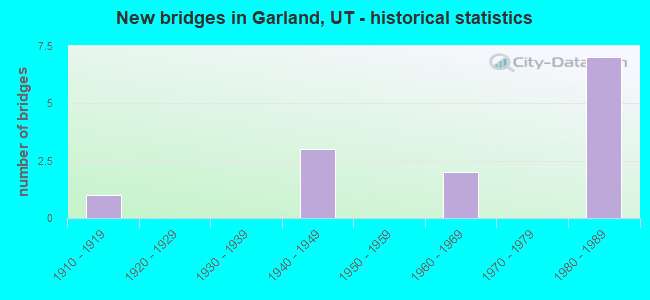
- New bridges - historical statistics
- 11910-1919
- 31940-1949
- 21960-1969
- 71980-1989
FCC Registered Antenna Towers:
28 (See the full list of FCC Registered Antenna Towers in Garland)FCC Registered Broadcast Land Mobile Towers:
6- Lat: 41.741583 Lon: -112.162167, Call Sign: WPVK731,
Assigned Frequencies: 453.762 MHz, Grant Date: 07/16/2012, Expiration Date: 07/03/2022, Cancellation Date: 09/03/2022, Certifier: William A Bishop, Registrant: Cara Enterprises Inc, Las Vegas, NV 81940-0124, Phone: (801) 278-9728, Fax: (702) 363-4607, Email:
- Lat: 41.725500 Lon: -112.161833, Call Sign: WQJN502,
Assigned Frequencies: 152.922 MHz, 152.997 MHz, Grant Date: 12/21/2018, Expiration Date: 11/07/2028, Certifier: Gary Allen, Registrant: Bear River High School, 1450 South Main, Garland, UT 84312, Phone: (435) 257-2500, Fax: (435) 257-3899, Email:
- Lat: 41.724944 Lon: -112.163194, Call Sign: WQKK670,
Assigned Frequencies: 72.1800 MHz, 72.2600 MHz, Grant Date: 06/25/2009, Expiration Date: 06/25/2019, Cancellation Date: 08/31/2019, Certifier: Jim Christensen, Registrant: Primex Wireless, Inc., 965 Wells Street, Lake Geneva, WI 53147, Phone: (262) 249-2344
- Lat: 41.741306 Lon: -112.162444, Call Sign: WQOE864,
Assigned Frequencies: 152.322 MHz, 152.412 MHz, 159.517 MHz, 159.727 MHz, 159.937 MHz, 160.132 MHz, 151.910 MHz, Grant Date: 09/16/2021, Expiration Date: 09/06/2031, Certifier: Pam Archuleta, Registrant: Lone Peak Licensing, LLC, Draper, UT 84020-1336, Phone: (801) 938-9346, Fax: (801) 938-9465, Email:
- Lat: 41.741583 Lon: -112.162167, Call Sign: WQPX740,
Assigned Frequencies: 453.762 MHz, Grant Date: 09/07/2022, Expiration Date: 09/12/2032, Certifier: Jay Munns, Registrant: Lone Peak Licensing, LLC, Draper, UT 84020-1336, Phone: (801) 938-9346, Fax: (801) 938-9465, Email:
- 300 E 1500 S (Lat: 41.725000 Lon: -112.158611), Call Sign: WRFL883,
Assigned Frequencies: 462.212 MHz, 467.212 MHz, 462.312 MHz, 467.312 MHz, 467.362 MHz, Grant Date: 03/26/2020, Expiration Date: 03/26/2030, Certifier: Eldon Petersen, Registrant: Utah Comm Inc, 1202 S 300 W, Salt Lake City, UT 84101, Phone: (801) 486-0161, Email:
FCC Registered Microwave Towers:
29 (See the full list of FCC Registered Microwave Towers in this town)FCC Registered Amateur Radio Licenses:
39 (See the full list of FCC Registered Amateur Radio Licenses in Garland)FAA Registered Aircraft:
3- Aircraft: MAULE MX-7-235 (Category: Land, Seats: 5, Weight: Up to 12,499 Pounds), Engine: LYCOMING IO-540 SER (300 HP) (Reciprocating)
N-Number: 235X, N235X, N-235X, Serial Number: 10054C, Year manufactured: 1987, Airworthiness Date: 02/12/1987, Certificate Issue Date: 05/13/2020
Registrant (Individual): Anthony Ford, 5670 W 13600 N, Garland, UT 84312 - Aircraft: PIPER PA-28-140 (Category: Land, Seats: 4, Weight: Up to 12,499 Pounds, Speed: 107 mph), Engine: LYCOMING 0-320 SERIES (180 HP) (Reciprocating)
N-Number: 54445, N54445, N-54445, Serial Number: 28-7425134, Year manufactured: 1973, Airworthiness Date: 11/21/1973, Certificate Issue Date: 11/07/2020
Registrant (Individual): Allen R Jensen, 1354 S 350 E, Garland, UT 84312 - Aircraft: POWRACHUTE AIRWOLF (Category: Land, Seats: 2, Weight: Up to 12,499 Pounds), Engine: ROTAX 912ULS SERIES (100 HP) (4 Cycle)
N-Number: 912LT, N912LT, N-912LT, Serial Number: A425 PEG, Year manufactured: 2004, Airworthiness Date: 04/04/2007, Certificate Issue Date: 01/22/2007
Registrant (Individual): Tim D Thompson, Po Box 335, Garland, UT 84312
2002 - 2018 National Fire Incident Reporting System (NFIRS) incidents
- Fire incident types reported to NFIRS in Garland, UT
- 5143.6%Outside Fires
- 4135.0%Structure Fires
- 1714.5%Mobile Property/Vehicle Fires
- 86.8%Other
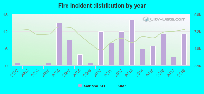 Based on the data from the years 2002 - 2018 the average number of fire incidents per year is 7. The highest number of fire incidents - 16 took place in 2013, and the least - 0 in 2003. The data has a rising trend.
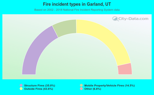 When looking into fire subcategories, the most reports belonged to: Outside Fires (43.6%), and Structure Fires (35.0%).
| Most common first names in Garland, UT among deceased individuals | ||
| Name | Count | Lived (average) |
|---|---|---|
| William | 9 | 78.8 years |
| Charles | 7 | 77.2 years |
| Mary | 7 | 82.5 years |
| John | 6 | 70.8 years |
| Arthur | 4 | 78.0 years |
| James | 4 | 80.5 years |
| David | 4 | 83.5 years |
| Frank | 4 | 89.0 years |
| Kenneth | 4 | 80.2 years |
| Mildred | 4 | 80.7 years |
| Most common last names in Garland, UT among deceased individuals | ||
| Last name | Count | Lived (average) |
|---|---|---|
| Coombs | 13 | 83.2 years |
| Anderson | 11 | 77.2 years |
| Wood | 10 | 80.6 years |
| Rhodes | 9 | 79.2 years |
| Jensen | 9 | 77.4 years |
| Johnson | 8 | 70.5 years |
| Udy | 8 | 81.0 years |
| Nelson | 7 | 72.3 years |
| Allred | 6 | 83.3 years |
| Thompson | 6 | 85.5 years |
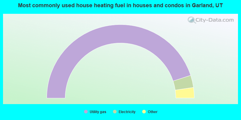
- 90.0%Utility gas
- 5.4%Electricity
- 2.7%Bottled, tank, or LP gas
- 1.9%Wood
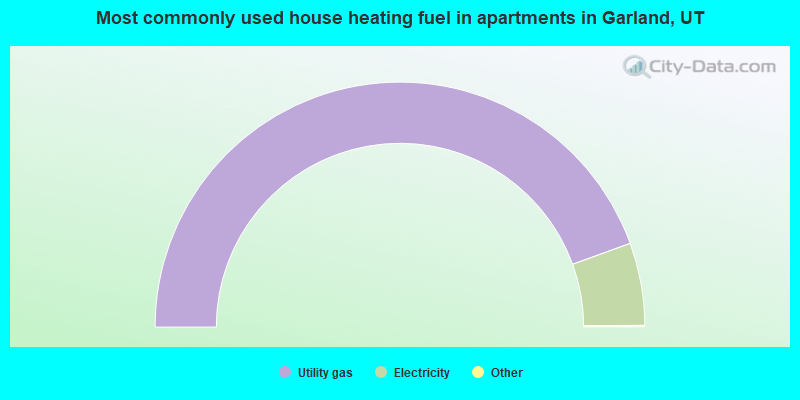
- 89.1%Utility gas
- 10.9%Electricity
Garland compared to Utah state average:
- Median household income below state average.
- Median house value below state average.
- Unemployed percentage below state average.
- Black race population percentage significantly below state average.
- Hispanic race population percentage above state average.
- Foreign-born population percentage significantly below state average.
- Length of stay since moving in significantly above state average.

|
Total of 3 patent applications in 2008-2024.