Bridge Statistics for Gary, Indiana (IN)
Condition, Traffic, Stress, Structural Evaluation, Project Costs
- National Bridge Inventory (NBI) Statistics
- 309Number of bridges
- 4,803ft / 1,464mTotal length
- $5,207,000Total costs
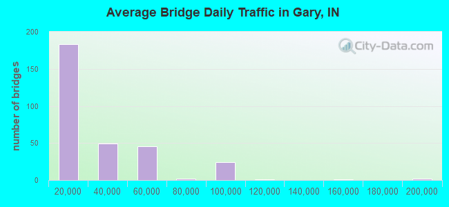
- 7,885,081Total average daily traffic
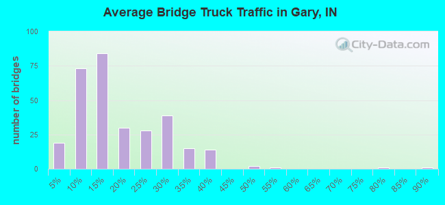
- 1,587,602Total average daily truck traffic
- National Bridge Inventory (NBI) Registered Bridges for Gary
- No street view available for this location
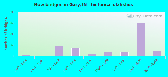
- New bridges - historical statistics
- 11920-1929
- 51930-1939
- 451950-1959
- 361960-1969
- 111970-1979
- 191980-1989
- 181990-1999
- 1512000-2009
- 232010-2019
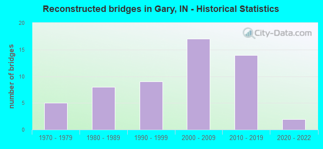
- Reconstructed bridges - Historical Statistics
- 51970-1979
- 81980-1989
- 91990-1999
- 172000-2009
- 142010-2019
- 22020-2022
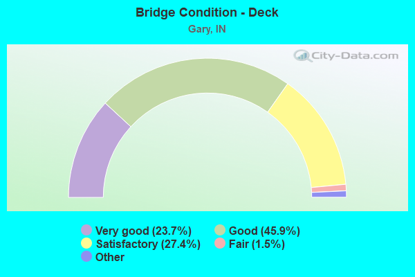
- Bridge Condition - Deck
- 23.7%Very good
- 45.9%Good
- 27.4%Satisfactory
- 1.5%Fair
- 1.5%Poor
- 0.7%Serious
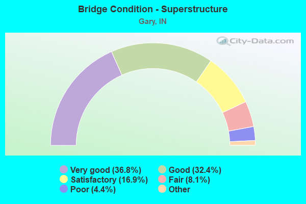
- Bridge Condition - Superstructure
- 36.8%Excellent
- 32.4%Very good
- 16.9%Good
- 8.1%Satisfactory
- 4.4%Fair
- 1.5%Poor
- 0.7%Serious
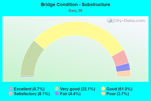
- Bridge Condition - Substructure
- 0.7%Excellent
- 22.1%Very good
- 61.0%Good
- 8.1%Satisfactory
- 4.4%Fair
- 3.7%Poor
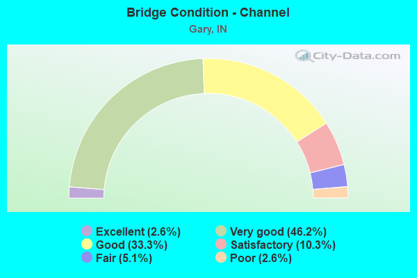
- Bridge Condition - Channel
- 2.6%Excellent
- 46.2%Very good
- 33.3%Good
- 10.3%Satisfactory
- 5.1%Fair
- 2.6%Poor
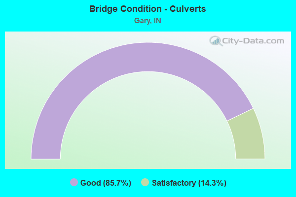
- Bridge Condition - Culverts
- 85.7%Good
- 14.3%Satisfactory
Find on map >> Show street view
Structure Number: 33166, Location: 00.03 W I-80 (Lat: 41.569519, Lng: -87.433289), Route carried "under" structure: State highway 912, Year Built: 2000, Structure Length: 0. m, Average Daily Traffic: 11,695 (year 2011), Truck Traffic: 15%, Features Intersected: SR 912 EB MAINLINE
Minimum Vertical Clearance: 5.18m (16.99ft), Kilometerpoint: 7.870, Lanes on structure: 1, Lanes under structure: 13, Material/Design: Prestressed concrete continuous, Design/Construction: Segmental Box Girder, Length of Maximum Span: 62.1m (203.7ft)
Find on map >> Show street view
Structure Number: 33166, Location: 00.03 W I-80 (Lat: 41.569519, Lng: -87.433289), Route carried "under" structure: State highway 912, Year Built: 2000, Structure Length: 0. m, Average Daily Traffic: 11,695 (year 2011), Truck Traffic: 15%, Features Intersected: SR 912 WB MAINLINE
Minimum Vertical Clearance: 5.18m (16.99ft), Kilometerpoint: 7.870, Lanes on structure: 1, Lanes under structure: 13, Material/Design: Prestressed concrete continuous, Design/Construction: Segmental Box Girder, Length of Maximum Span: 62.1m (203.7ft)
Find on map >> Show street view
Structure Number: 33166, Location: 00.03 W I-80 (Lat: 41.569519, Lng: -87.433289), Route carried "under" structure: Interstate 80, Year Built: 2000, Structure Length: 0. m, Average Daily Traffic: 40,735 (year 2011), Truck Traffic: 25%, Features Intersected: I-80/94 WB MAINLINE
Minimum Vertical Clearance: 5.18m (16.99ft), Kilometerpoint: 7.870, Lanes on structure: 1, Lanes under structure: 13, Toll: On toll road, Material/Design: Prestressed concrete continuous, Design/Construction: Segmental Box Girder, Length of Maximum Span: 62.1m (203.7ft)
Find on map >> Show street view
Structure Number: 33166, Location: 00.03 W I-80 (Lat: 41.569519, Lng: -87.433289), Route carried "under" structure: Ramp State highway 912, Year Built: 2000, Structure Length: 0. m, Average Daily Traffic: 9,810 (year 2011), Truck Traffic: 15%, Features Intersected: SR 912 EB RAMP
Minimum Vertical Clearance: 5.18m (16.99ft), Kilometerpoint: 7.870, Lanes on structure: 1, Lanes under structure: 13, Material/Design: Prestressed concrete continuous, Design/Construction: Segmental Box Girder, Length of Maximum Span: 62.1m (203.7ft)
Find on map >> Show street view
Structure Number: 33166, Location: 00.03 W I-80 (Lat: 41.569519, Lng: -87.433289), Route carried "under" structure: Interstate 80, Year Built: 2000, Structure Length: 0. m, Average Daily Traffic: 40,735 (year 2011), Truck Traffic: 25%, Features Intersected: I-80/94 EB MAINLINE
Minimum Vertical Clearance: 5.18m (16.99ft), Kilometerpoint: 7.870, Lanes on structure: 1, Lanes under structure: 13, Toll: On toll road, Material/Design: Prestressed concrete continuous, Design/Construction: Segmental Box Girder, Length of Maximum Span: 62.1m (203.7ft)
Find on map >> Show street view
Structure Number: 3864, Location: 03.53 N US-30 (Lat: 41.522061, Lng: -87.317519), Route carried "under" structure: City street , Year Built: 1965, Structure Length: 0. m, Average Daily Traffic: 4,111 (year 2004), Truck Traffic: 10%, Features Intersected: 53RD AVENUE, Facility Carried by Structure: I-65 NB
Minimum Vertical Clearance: 4.60m (15.09ft), Kilometerpoint: 0.000, Lanes on structure: 3, Lanes under structure: 2, Material/Design: Prestressed concrete continuous, Design/Construction: Slab, Length of Maximum Span: 14.2m (46.6ft)
Find on map >> Show street view
Structure Number: 3865, Location: 03.53 N US-30 (Lat: 41.522081, Lng: -87.317733), Route carried "under" structure: City street , Year Built: 1965, Structure Length: 0. m, Average Daily Traffic: 4,111 (year 2004), Truck Traffic: 10%, Features Intersected: 53RD AVENUE, Facility Carried by Structure: I-65 SB
Minimum Vertical Clearance: 4.60m (15.09ft), Kilometerpoint: 0.000, Lanes on structure: 3, Lanes under structure: 2, Material/Design: Prestressed concrete continuous, Design/Construction: Slab, Length of Maximum Span: 14.2m (46.6ft)
Find on map >> Show street view
Structure Number: 3868, Location: 04.06 N US-30 (Lat: 41.529289, Lng: -87.313981), Route carried "under" structure: City street , Year Built: 1965, Structure Length: 0. m, Average Daily Traffic: 4,376 (year 2004), Truck Traffic: 10%, Features Intersected: I-65 NB, Facility Carried by Structure: 49TH AVENUE
Minimum Vertical Clearance: 4.57m (14.99ft), Kilometerpoint: 0.000, Lanes on structure: 3, Lanes under structure: 2, Material/Design: Concrete continuous, Design/Construction: Slab, Length of Maximum Span: 14.0m (45.9ft)
Find on map >> Show street view
Structure Number: 3869, Location: 04.06 N US-30 (Lat: 41.529319, Lng: -87.314233), Route carried "under" structure: City street , Year Built: 1965, Structure Length: 0. m, Average Daily Traffic: 4,376 (year 2004), Truck Traffic: 10%, Features Intersected: I-65 SB, Facility Carried by Structure: 49TH AVENUE
Minimum Vertical Clearance: 4.72m (15.49ft), Kilometerpoint: 0.000, Lanes on structure: 3, Lanes under structure: 2, Material/Design: Concrete continuous, Design/Construction: Slab, Length of Maximum Span: 14.0m (45.9ft)
Find on map >> Show street view
Structure Number: 3872, Location: 05.33 N US-30 (Lat: 41.547511, Lng: -87.310867), Route carried "under" structure: City street , Year Built: 1965, Structure Length: 0. m, Average Daily Traffic: 541 (year 2004), Truck Traffic: 10%, Features Intersected: I-65 NB, Facility Carried by Structure: 39TH AVENUE
Minimum Vertical Clearance: 4.50m (14.76ft), Kilometerpoint: 0.000, Lanes on structure: 4, Lanes under structure: 2, Material/Design: Steel continuous, Design/Construction: Stringer/Multi-beam, Length of Maximum Span: 20.9m (68.6ft)
Find on map >> Show street view
Structure Number: 3873, Location: 05.33 N US-30 (Lat: 41.547489, Lng: -87.311181), Route carried "under" structure: City street , Year Built: 1965, Structure Length: 0. m, Average Daily Traffic: 541 (year 2004), Truck Traffic: 10%, Features Intersected: I-65 SB, Facility Carried by Structure: 39TH AVENUE
Minimum Vertical Clearance: 4.50m (14.76ft), Kilometerpoint: 0.000, Lanes on structure: 4, Lanes under structure: 2, Material/Design: Steel continuous, Design/Construction: Stringer/Multi-beam, Length of Maximum Span: 20.9m (68.6ft)
Find on map >> Show street view
Structure Number: 3874, Location: 05.61 N US-30 (Lat: 41.551161, Lng: -87.310989), Route carried "under" structure: City street , Year Built: 2001, Structure Length: 0. m, Average Daily Traffic: 9,290 (year 2004), Truck Traffic: 10%, Features Intersected: 37TH AVE (OLD US 6) WBL, Facility Carried by Structure: I-65 NB
Minimum Vertical Clearance: 4.90m (16.08ft), Kilometerpoint: 0.000, Lanes on structure: 4, Lanes under structure: 5, Material/Design: Steel, Design/Construction: Stringer/Multi-beam, Length of Maximum Span: 36.0m (118.1ft)
Find on map >> Show street view
Structure Number: 3874, Location: 05.61 N US-30 (Lat: 41.551161, Lng: -87.310989), Route carried "under" structure: City street , Year Built: 2001, Structure Length: 0. m, Average Daily Traffic: 9,290 (year 2004), Truck Traffic: 10%, Features Intersected: 37TH AVE (OLD US 6) EBL, Facility Carried by Structure: I-65 NB
Minimum Vertical Clearance: 4.90m (16.08ft), Kilometerpoint: 0.000, Lanes on structure: 4, Lanes under structure: 5, Material/Design: Steel, Design/Construction: Stringer/Multi-beam, Length of Maximum Span: 36.0m (118.1ft)
Find on map >> Show street view
Structure Number: 3875, Location: 05.61 N US-30 (Lat: 41.551169, Lng: -87.311256), Route carried "under" structure: City street , Year Built: 2001, Structure Length: 0. m, Average Daily Traffic: 9,290 (year 2004), Truck Traffic: 10%, Features Intersected: 37TH AVE (OLD US 6) EBL, Facility Carried by Structure: I-65 SB
Minimum Vertical Clearance: 4.90m (16.08ft), Kilometerpoint: 0.000, Lanes on structure: 4, Lanes under structure: 5, Material/Design: Steel, Design/Construction: Stringer/Multi-beam, Length of Maximum Span: 36.0m (118.1ft)
Find on map >> Show street view
Structure Number: 3875, Location: 05.61 N US-30 (Lat: 41.551169, Lng: -87.311256), Route carried "under" structure: City street , Year Built: 2001, Structure Length: 0. m, Average Daily Traffic: 9,290 (year 2004), Truck Traffic: 10%, Features Intersected: 37TH AVE (OLD US 6) WBL, Facility Carried by Structure: I-65 SB
Minimum Vertical Clearance: 4.90m (16.08ft), Kilometerpoint: 0.000, Lanes on structure: 4, Lanes under structure: 5, Material/Design: Steel, Design/Construction: Stringer/Multi-beam, Length of Maximum Span: 36.0m (118.1ft)
Find on map >> Show street view
Structure Number: 3878, Location: 05.84 N US-30 (Lat: 41.554731, Lng: -87.310997), Route carried "under" structure: City street , Year Built: 2001, Structure Length: 0. m, Average Daily Traffic: 541 (year 2004), Truck Traffic: 10%, Features Intersected: I-65 NB, Facility Carried by Structure: 35TH AVENUE
Minimum Vertical Clearance: 5.03m (16.50ft), Kilometerpoint: 0.000, Lanes on structure: 4, Lanes under structure: 2, Material/Design: Prestressed concrete, Design/Construction: Tee Beam, Length of Maximum Span: 25.0m (82.0ft)
Find on map >> Show street view
Structure Number: 3879, Location: 05.84 N US 30 (Lat: 41.554731, Lng: -87.311317), Route carried "under" structure: City street , Year Built: 2001, Structure Length: 0. m, Average Daily Traffic: 541 (year 2004), Truck Traffic: 10%, Features Intersected: I-65 SB, Facility Carried by Structure: 35TH AVENUE
Minimum Vertical Clearance: 5.03m (16.50ft), Kilometerpoint: 0.000, Lanes on structure: 4, Lanes under structure: 2, Material/Design: Prestressed concrete, Design/Construction: Tee Beam, Length of Maximum Span: 25.0m (82.0ft)
Find on map >> Show street view
Structure Number: 3886, Location: 00.66 N I-80 (Lat: 41.577331, Lng: -87.295875), Route carried "under" structure: City street , Year Built: 1965, Structure Length: 0. m, Average Daily Traffic: 118 (year 2004), Truck Traffic: 10%, Features Intersected: CENTRAL AVENUE, Facility Carried by Structure: I-65 NB
Minimum Vertical Clearance: 6.96m (22.83ft), Kilometerpoint: 0.000, Lanes on structure: 2, Lanes under structure: 2, Material/Design: Steel continuous, Design/Construction: Stringer/Multi-beam, Length of Maximum Span: 24.4m (80.1ft)
Find on map >> Show street view
Structure Number: 3887, Location: 00.66 N I-80 (Lat: 41.577439, Lng: -87.296228), Route carried "under" structure: City street , Year Built: 1965, Structure Length: 0. m, Average Daily Traffic: 118 (year 2004), Truck Traffic: 10%, Features Intersected: CENTRAL AVENUE, Facility Carried by Structure: I-65 SB
Minimum Vertical Clearance: 7.98m (26.18ft), Kilometerpoint: 0.000, Lanes on structure: 2, Lanes under structure: 2, Material/Design: Steel continuous, Design/Construction: Stringer/Multi-beam, Length of Maximum Span: 24.4m (80.1ft)
Find on map >> Show street view
Structure Number: 3888, Location: 01.53 N I-80 (Lat: 41.587339, Lng: -87.306228), Route carried "under" structure: City street , Year Built: 1965, Structure Length: 0. m, Average Daily Traffic: 14,443 (year 2004), Truck Traffic: 10%, Features Intersected: 15th AVENUE, Facility Carried by Structure: I-65 NB
Minimum Vertical Clearance: 4.42m (14.50ft), Kilometerpoint: 0.000, Lanes on structure: 3, Lanes under structure: 4, Material/Design: Steel continuous, Design/Construction: Stringer/Multi-beam, Length of Maximum Span: 21.9m (71.9ft)
Find on map >> Show street view
Structure Number: 3889, Location: 01.53 N I-80 (Lat: 41.587339, Lng: -87.306633), Route carried "under" structure: City street , Year Built: 1965, Structure Length: 0. m, Average Daily Traffic: 14,443 (year 2004), Truck Traffic: 10%, Features Intersected: 15th AVENUE, Facility Carried by Structure: I-65 SB
Minimum Vertical Clearance: 4.42m (14.50ft), Kilometerpoint: 0.000, Lanes on structure: 2, Lanes under structure: 5, Material/Design: Steel continuous, Design/Construction: Stringer/Multi-beam, Length of Maximum Span: 21.9m (71.9ft)
Find on map >> Show street view
Structure Number: 45599, Location: 02.52 E US-41 (Lat: 41.570300, Lng: -87.432419), Route carried "under" structure: Ramp State highway 912, Year Built: 2001, Structure Length: 0. m, Average Daily Traffic: 2,717 (year 2021), Truck Traffic: 4%, Features Intersected: SR-912 EBL-CD-RAMP, Facility Carried by Structure: I-80 WB RAMP TO SR
Minimum Vertical Clearance: 5.03m (16.50ft), Kilometerpoint: 16.737, Lanes on structure: 1, Lanes under structure: 9, Material/Design: Steel continuous, Design/Construction: Stringer/Multi-beam, Length of Maximum Span: 19.1m (62.7ft)
Find on map >> Show street view
Structure Number: 45599, Location: 02.52 E US-41 (Lat: 41.570300, Lng: -87.432419), Route carried "under" structure: Ramp State highway 912, Year Built: 2001, Structure Length: 0. m, Average Daily Traffic: 9,903 (year 2020), Truck Traffic: 13%, Features Intersected: SR-912 WBL-CD-RAMP, Facility Carried by Structure: I-80 WB RAMP TO SR
Minimum Vertical Clearance: 5.03m (16.50ft), Kilometerpoint: 16.737, Lanes on structure: 1, Lanes under structure: 9, Material/Design: Steel continuous, Design/Construction: Stringer/Multi-beam, Length of Maximum Span: 19.1m (62.7ft)
Find on map >> Show street view
Structure Number: 45599, Location: 02.52 E US-41 (Lat: 41.570300, Lng: -87.432419), Route carried "under" structure: State highway 912, Year Built: 2001, Structure Length: 0. m, Average Daily Traffic: 2,717 (year 2021), Truck Traffic: 4%, Features Intersected: SR-912 WBL, Facility Carried by Structure: I-80 WB RAMP TO SR
Minimum Vertical Clearance: 5.03m (16.50ft), Kilometerpoint: 16.737, Lanes on structure: 1, Lanes under structure: 9, Material/Design: Steel continuous, Design/Construction: Stringer/Multi-beam, Length of Maximum Span: 19.1m (62.7ft)
Find on map >> Show street view
Structure Number: 45599, Location: 02.52 E US-41 (Lat: 41.570300, Lng: -87.432419), Route carried "under" structure: State highway 912, Year Built: 2001, Structure Length: 0. m, Average Daily Traffic: 44,400 (year 2004), Truck Traffic: 10%, Features Intersected: SR-912 EBL, Facility Carried by Structure: I-80 WB RAMP TO SR
Minimum Vertical Clearance: 5.03m (16.50ft), Kilometerpoint: 16.737, Lanes on structure: 1, Lanes under structure: 9, Material/Design: Steel continuous, Design/Construction: Stringer/Multi-beam, Length of Maximum Span: 19.1m (62.7ft)
Find on map >> Show street view
Structure Number: 456, Location: 02.53 E US-41 (Lat: 41.570061, Lng: -87.432472), Route carried "under" structure: State highway 912, Year Built: 2001, Structure Length: 0. m, Average Daily Traffic: 40,340 (year 2020), Truck Traffic: 15%, Features Intersected: SR-912 EBL, Facility Carried by Structure: I-80 EB/WB
Minimum Vertical Clearance: 5.05m (16.57ft), Kilometerpoint: 16.753, Lanes on structure: 8, Lanes under structure: 9, Material/Design: Steel continuous, Design/Construction: Stringer/Multi-beam, Length of Maximum Span: 19.1m (62.7ft)
Find on map >> Show street view
Structure Number: 456, Location: 02.53 E US-41 (Lat: 41.570061, Lng: -87.432472), Route carried "under" structure: Ramp State highway 912, Year Built: 2001, Structure Length: 0. m, Average Daily Traffic: 40,340 (year 2020), Truck Traffic: 15%, Features Intersected: SR-912 WBL, Facility Carried by Structure: I-80 EB/WB
Minimum Vertical Clearance: 5.05m (16.57ft), Kilometerpoint: 16.753, Lanes on structure: 8, Lanes under structure: 9, Material/Design: Steel continuous, Design/Construction: Stringer/Multi-beam, Length of Maximum Span: 19.1m (62.7ft)
Find on map >> Show street view
Structure Number: 456, Location: 02.53 E US-41 (Lat: 41.570061, Lng: -87.432472), Route carried "under" structure: Ramp State highway 912, Year Built: 2001, Structure Length: 0. m, Average Daily Traffic: 3,500 (year 2020), Truck Traffic: 15%, Features Intersected: SR-912 WBL-CD-RAMP, Facility Carried by Structure: I-80 EB/WB
Minimum Vertical Clearance: 5.05m (16.57ft), Kilometerpoint: 16.753, Lanes on structure: 8, Lanes under structure: 9, Material/Design: Steel continuous, Design/Construction: Stringer/Multi-beam, Length of Maximum Span: 19.1m (62.7ft)
Find on map >> Show street view
Structure Number: 45601, Location: 02.54 E US-41 (Lat: 41.569811, Lng: -87.432503), Route carried "under" structure: State highway 912, Year Built: 2001, Structure Length: 0. m, Average Daily Traffic: 44,400 (year 2004), Truck Traffic: 10%, Features Intersected: SR-912 WBL
Minimum Vertical Clearance: 6.00m (19.69ft), Kilometerpoint: 16.785, Lanes on structure: 2, Lanes under structure: 9, Material/Design: Steel continuous, Design/Construction: Stringer/Multi-beam, Length of Maximum Span: 19.1m (62.7ft)
Find on map >> Show street view
Structure Number: 45601, Location: 02.54 E US-41 (Lat: 41.569811, Lng: -87.432503), Route carried "under" structure: State highway 912, Year Built: 2001, Structure Length: 0. m, Average Daily Traffic: 44,400 (year 2004), Truck Traffic: 10%, Features Intersected: SR-912 EBL
Minimum Vertical Clearance: 6.00m (19.69ft), Kilometerpoint: 16.785, Lanes on structure: 2, Lanes under structure: 9, Material/Design: Steel continuous, Design/Construction: Stringer/Multi-beam, Length of Maximum Span: 19.1m (62.7ft)
Find on map >> Show street view
Structure Number: 45601, Location: 02.54 E US-41 (Lat: 41.569811, Lng: -87.432503), Route carried "under" structure: Ramp State highway 912, Year Built: 2001, Structure Length: 0. m, Average Daily Traffic: 3,500 (year 2004), Truck Traffic: 10%, Features Intersected: SR-912 EBL-CD-RAMP
Minimum Vertical Clearance: 6.00m (19.69ft), Kilometerpoint: 16.785, Lanes on structure: 2, Lanes under structure: 9, Material/Design: Steel continuous, Design/Construction: Stringer/Multi-beam, Length of Maximum Span: 19.1m (62.7ft)
Find on map >> Show street view
Structure Number: 45601, Location: 02.54 E US-41 (Lat: 41.569811, Lng: -87.432503), Route carried "under" structure: Ramp State highway 912, Year Built: 2001, Structure Length: 0. m, Average Daily Traffic: 3,500 (year 2004), Truck Traffic: 10%, Features Intersected: SR-912 WBL-CD-RAMP
Minimum Vertical Clearance: 6.00m (19.69ft), Kilometerpoint: 16.785, Lanes on structure: 2, Lanes under structure: 9, Material/Design: Steel continuous, Design/Construction: Stringer/Multi-beam, Length of Maximum Span: 19.1m (62.7ft)
Find on map >> Show street view
Structure Number: 4563, Location: 01.02 E SR-912 (Lat: 41.569939, Lng: -87.413108), Route carried "under" structure: Interstate 80, Year Built: 1994, Structure Length: 0. m, Average Daily Traffic: 92,355 (year 2006), Truck Traffic: 30%, Features Intersected: I-80 (I-94) EBL, Facility Carried by Structure: COLFAX STREET
Minimum Vertical Clearance: 5.21m (17.09ft), Kilometerpoint: 9.527, Lanes on structure: 2, Lanes under structure: 10, Material/Design: Steel continuous, Design/Construction: Stringer/Multi-beam, Length of Maximum Span: 31.2m (102.4ft)
Find on map >> Show street view
Structure Number: 4563, Location: 01.02 E SR-912 (Lat: 41.569939, Lng: -87.413108), Route carried "under" structure: Interstate 80, Year Built: 1994, Structure Length: 0. m, Average Daily Traffic: 96,178 (year 2006), Truck Traffic: 30%, Features Intersected: I-80 (I-94) WBL, Facility Carried by Structure: COLFAX STREET
Minimum Vertical Clearance: 5.21m (17.09ft), Kilometerpoint: 9.527, Lanes on structure: 2, Lanes under structure: 10, Material/Design: Steel continuous, Design/Construction: Stringer/Multi-beam, Length of Maximum Span: 31.2m (102.4ft)
Find on map >> Show street view
Structure Number: 4564, Location: 01.51 E SR-912 (Lat: 41.569881, Lng: -87.403306), Route carried "under" structure: Interstate 80, Year Built: 2000, Structure Length: 0. m, Average Daily Traffic: 96,230 (year 2004), Truck Traffic: 30%, Features Intersected: I-80 EBL, Facility Carried by Structure: BURR STREET
Minimum Vertical Clearance: 5.05m (16.57ft), Kilometerpoint: 10.332, Lanes on structure: 6, Lanes under structure: 8, Material/Design: Steel continuous, Design/Construction: Stringer/Multi-beam, Length of Maximum Span: 36.0m (118.1ft)
Find on map >> Show street view
Structure Number: 4564, Location: 01.51 E SR-912 (Lat: 41.569881, Lng: -87.403306), Route carried "under" structure: Interstate 80, Year Built: 2000, Structure Length: 0. m, Average Daily Traffic: 96,230 (year 2004), Truck Traffic: 30%, Features Intersected: I-80 WBL, Facility Carried by Structure: BURR STREET
Minimum Vertical Clearance: 5.05m (16.57ft), Kilometerpoint: 10.332, Lanes on structure: 6, Lanes under structure: 8, Material/Design: Steel continuous, Design/Construction: Stringer/Multi-beam, Length of Maximum Span: 36.0m (118.1ft)
Find on map >> Show street view
Structure Number: 4564, Location: 01.51 E SR-912 (Lat: 41.569881, Lng: -87.403306), Route carried "under" structure: Ramp Interstate 80, Year Built: 2000, Structure Length: 0. m, Average Daily Traffic: 3,500 (year 2004), Truck Traffic: 10%, Features Intersected: I-80 EBL-CD-RAMP, Facility Carried by Structure: BURR STREET
Minimum Vertical Clearance: 5.05m (16.57ft), Kilometerpoint: 10.332, Lanes on structure: 6, Lanes under structure: 8, Material/Design: Steel continuous, Design/Construction: Stringer/Multi-beam, Length of Maximum Span: 36.0m (118.1ft)
Find on map >> Show street view
Structure Number: 4565, Location: 02.02 E of SR 912 (Lat: 41.569850, Lng: -87.393861), Route carried "under" structure: Interstate 80, Year Built: 2002, Structure Length: 0. m, Average Daily Traffic: 96,221 (year 2004), Truck Traffic: 10%, Features Intersected: I-80 EBL, Facility Carried by Structure: CLARK STREET
Minimum Vertical Clearance: 5.03m (16.50ft), Kilometerpoint: 11.153, Lanes on structure: 4, Lanes under structure: 10, Material/Design: Prestressed concrete continuous, Design/Construction: Tee Beam, Length of Maximum Span: 33.3m (109.3ft)
Find on map >> Show street view
Structure Number: 4565, Location: 02.02 E of SR 912 (Lat: 41.569850, Lng: -87.393861), Route carried "under" structure: Interstate 80, Year Built: 2002, Structure Length: 0. m, Average Daily Traffic: 96,221 (year 2004), Truck Traffic: 50%, Features Intersected: I-80 WBL, Facility Carried by Structure: CLARK STREET
Minimum Vertical Clearance: 5.03m (16.50ft), Kilometerpoint: 11.153, Lanes on structure: 4, Lanes under structure: 10, Material/Design: Prestressed concrete continuous, Design/Construction: Tee Beam, Length of Maximum Span: 33.3m (109.3ft)
Find on map >> Show street view
Structure Number: 4568, Location: 00.48 W of SR-53 (Lat: 41.567650, Lng: -87.346367), Route carried "under" structure: Interstate 80, Year Built: 2002, Structure Length: 0. m, Average Daily Traffic: 95,300 (year 2004), Truck Traffic: 10%, Features Intersected: I-80 EBL, Facility Carried by Structure: HARRISON STREET
Minimum Vertical Clearance: 5.03m (16.50ft), Kilometerpoint: 15.144, Lanes on structure: 4, Lanes under structure: 10, Material/Design: Prestressed concrete continuous, Design/Construction: Tee Beam, Length of Maximum Span: 33.5m (109.9ft)
Find on map >> Show street view
Structure Number: 4568, Location: 00.48 W of SR-53 (Lat: 41.567650, Lng: -87.346367), Route carried "under" structure: Interstate 80, Year Built: 2002, Structure Length: 0. m, Average Daily Traffic: 95,300 (year 2004), Truck Traffic: 10%, Features Intersected: I-80 WBL, Facility Carried by Structure: HARRISON STREET
Minimum Vertical Clearance: 5.03m (16.50ft), Kilometerpoint: 15.144, Lanes on structure: 4, Lanes under structure: 10, Material/Design: Prestressed concrete continuous, Design/Construction: Tee Beam, Length of Maximum Span: 33.5m (109.9ft)
Find on map >> Show street view
Structure Number: 4582, Location: 00.38 W I-90 (Lat: 41.586111, Lng: -87.231461), Route carried "under" structure: Ramp Interstate 94, Year Built: 1963, Structure Length: 0. m, Average Daily Traffic: 10,148 (year 2015), Truck Traffic: 46%, Features Intersected: I-94 OFF RAMP 15V, Facility Carried by Structure: I-80 EB
Minimum Vertical Clearance: 4.98m (16.34ft), Kilometerpoint: 24.961, Lanes on structure: 2, Lanes under structure: 8, Toll: On toll road, Material/Design: Steel continuous, Design/Construction: Stringer/Multi-beam, Length of Maximum Span: 21.5m (70.5ft)
Find on map >> Show street view
Structure Number: 4582, Location: 00.38 W I-90 (Lat: 41.586111, Lng: -87.231461), Route carried "under" structure: Interstate 94, Year Built: 1963, Structure Length: 0. m, Average Daily Traffic: 83,907 (year 2014), Truck Traffic: 16%, Features Intersected: I-94 WBL, Facility Carried by Structure: I-80 EB
Minimum Vertical Clearance: 5.16m (16.93ft), Kilometerpoint: 24.961, Lanes on structure: 2, Lanes under structure: 8, Toll: On toll road, Material/Design: Steel continuous, Design/Construction: Stringer/Multi-beam, Length of Maximum Span: 21.5m (70.5ft)
Find on map >> Show street view
Structure Number: 4582, Location: 00.38 W I-90 (Lat: 41.586111, Lng: -87.231461), Route carried "under" structure: Interstate 94, Year Built: 1963, Structure Length: 0. m, Average Daily Traffic: 83,907 (year 2014), Truck Traffic: 35%, Features Intersected: I-94 EBL, Facility Carried by Structure: I-80 EB
Minimum Vertical Clearance: 5.16m (16.93ft), Kilometerpoint: 24.961, Lanes on structure: 2, Lanes under structure: 8, Toll: On toll road, Material/Design: Steel continuous, Design/Construction: Stringer/Multi-beam, Length of Maximum Span: 21.5m (70.5ft)
Find on map >> Show street view
Structure Number: 4582, Location: 00.38 W I-90 (Lat: 41.586111, Lng: -87.231461), Route carried "under" structure: Ramp Interstate 94, Year Built: 1963, Structure Length: 0. m, Average Daily Traffic: 4,321 (year 2015), Truck Traffic: 13%, Features Intersected: I-94 OFF RAMP 15C, Facility Carried by Structure: I-80 EB
Minimum Vertical Clearance: 4.95m (16.24ft), Kilometerpoint: 24.961, Lanes on structure: 2, Lanes under structure: 8, Toll: On toll road, Material/Design: Steel continuous, Design/Construction: Stringer/Multi-beam, Length of Maximum Span: 21.5m (70.5ft)
Find on map >> Show street view
Structure Number: 4583, Location: 00.31 W I-90 (Lat: 41.585619, Lng: -87.234017), Route carried "under" structure: Ramp Interstate 80, Year Built: 1966, Structure Length: 0. m, Average Daily Traffic: 19,736 (year 2004), Truck Traffic: 15%, Features Intersected: RAMP M (I90 TO WB I80, Facility Carried by Structure: RAMP L-WB TO SR 51
Minimum Vertical Clearance: 4.95m (16.24ft), Kilometerpoint: 25.074, Lanes on structure: 1, Lanes under structure: 1, Material/Design: Prestressed concrete continuous, Design/Construction: Stringer/Multi-beam, Length of Maximum Span: 17.1m (56.1ft)
Find on map >> Show street view
Structure Number: 46295, Location: 00.64 E SR 912 (Lat: 41.609700, Lng: -87.423058), Route carried "under" structure: Ramp State highway 90, Year Built: 1984, Structure Length: 0. m, Average Daily Traffic: 2,900 (year 2015), Truck Traffic: 21%, Features Intersected: SR912 TO I-90 EBL
Minimum Vertical Clearance: 6.10m (20.01ft), Kilometerpoint: 16.335, Lanes on structure: 1, Lanes under structure: 1, Toll: On toll road, Material/Design: Steel continuous, Design/Construction: Stringer/Multi-beam, Length of Maximum Span: 37.5m (123.0ft)
Find on map >> Show street view
Structure Number: 46295, Location: 00.64 E SR 912 (Lat: 41.609700, Lng: -87.423058), Route carried "under" structure: Interstate 90, Year Built: 1984, Structure Length: 0. m, Average Daily Traffic: 34,510 (year 2015), Truck Traffic: 5%, Features Intersected: I-90 WB
Minimum Vertical Clearance: 5.13m (16.83ft), Kilometerpoint: 16.335, Lanes on structure: 1, Lanes under structure: 2, Toll: On toll road, Material/Design: Steel continuous, Design/Construction: Stringer/Multi-beam, Length of Maximum Span: 37.5m (123.0ft)
Find on map >> Show street view
Structure Number: 46295, Location: 00.64 E SR 912 (Lat: 41.609700, Lng: -87.423058), Route carried "under" structure: Interstate 90, Year Built: 1984, Structure Length: 0. m, Average Daily Traffic: 34,510 (year 2015), Truck Traffic: 11%, Features Intersected: I-90 EB
Minimum Vertical Clearance: 5.13m (16.83ft), Kilometerpoint: 16.335, Lanes on structure: 1, Lanes under structure: 2, Toll: On toll road, Material/Design: Steel continuous, Design/Construction: Stringer/Multi-beam, Length of Maximum Span: 37.5m (123.0ft)
Find on map >> Show street view
Structure Number: 46297, Location: 00.00 JCT I-90 (Lat: 41.609731, Lng: -87.421914), Route carried "under" structure: Ramp Interstate 90, Year Built: 1984, Structure Length: 0. m, Average Daily Traffic: 2,900 (year 2015), Truck Traffic: 21%, Features Intersected: SR 912E RAMP TO I-90 EBL
Minimum Vertical Clearance: 5.64m (18.50ft), Kilometerpoint: 16.415, Lanes on structure: 2, Lanes under structure: 1, Toll: On toll road, Material/Design: Steel, Design/Construction: Stringer/Multi-beam, Length of Maximum Span: 20.1m (65.9ft)
Find on map >> Show street view
Structure Number: 46298, Location: 00.00 JCT I-90 (Lat: 41.609839, Lng: -87.421967), Route carried "under" structure: Ramp Interstate 90, Year Built: 1984, Structure Length: 0. m, Average Daily Traffic: 2,900 (year 2015), Truck Traffic: 21%, Features Intersected: SR 912E RAMP TO I-90 EBL
Minimum Vertical Clearance: 5.64m (18.50ft), Kilometerpoint: 16.415, Lanes on structure: 2, Lanes under structure: 1, Toll: On toll road, Material/Design: Steel, Design/Construction: Stringer/Multi-beam, Length of Maximum Span: 20.1m (65.9ft)
Find on map >> Show street view
Structure Number: 4632, Location: 02.03 E SR 912 (Lat: 41.609031, Lng: -87.385811), Route carried "under" structure: City street , Year Built: 1956, Structure Length: 0. m, Average Daily Traffic: 10,736 (year 2011), Truck Traffic: 5%, Features Intersected: AIRPORT RD, Facility Carried by Structure: I-90 EB
Minimum Vertical Clearance: 5.08m (16.67ft), Kilometerpoint: 16.946, Lanes on structure: 3, Lanes under structure: 4, Material/Design: Steel, Design/Construction: Stringer/Multi-beam, Length of Maximum Span: 29.0m (95.1ft)
Find on map >> Show street view
Structure Number: 4632, Location: 02.03 E SR 912 (Lat: 41.609031, Lng: -87.385811), Route carried "under" structure: ServiceCity street , Year Built: 1956, Structure Length: 0. m, Average Daily Traffic: 100 (year 2014), Truck Traffic: 1%, Features Intersected: CLARK/1ST AVE, Facility Carried by Structure: I-90 EB
Minimum Vertical Clearance: 4.47m (14.67ft), Kilometerpoint: 16.946, Lanes on structure: 3, Lanes under structure: 2, Material/Design: Steel, Design/Construction: Stringer/Multi-beam, Length of Maximum Span: 29.0m (95.1ft)
Find on map >> Show street view
Structure Number: 4633, Location: 02.03 E SR 912 (Lat: 41.607639, Lng: -87.393669), Route carried "under" structure: City street , Year Built: 1956, Structure Length: 0. m, Average Daily Traffic: 10,736 (year 2011), Truck Traffic: 5%, Features Intersected: AIRPORT RD, Facility Carried by Structure: I-90 WB
Minimum Vertical Clearance: 4.47m (14.67ft), Kilometerpoint: 16.930, Lanes on structure: 3, Lanes under structure: 4, Material/Design: Steel, Design/Construction: Stringer/Multi-beam, Length of Maximum Span: 29.0m (95.1ft)
Find on map >> Show street view
Structure Number: 4633, Location: 02.03 E SR 912 (Lat: 41.609150, Lng: -87.386017), Route carried "under" structure: ServiceCity street , Year Built: 1956, Structure Length: 0. m, Average Daily Traffic: 100 (year 2014), Truck Traffic: 1%, Features Intersected: CLARK RD/1ST AVE, Facility Carried by Structure: I-90 WB
Minimum Vertical Clearance: 4.47m (14.67ft), Kilometerpoint: 16.930, Lanes on structure: 3, Lanes under structure: 2, Material/Design: Steel, Design/Construction: Stringer/Multi-beam, Length of Maximum Span: 29.0m (95.1ft)
Find on map >> Show street view
Structure Number: 4638, Location: 01.15 E US 12 (Lat: 41.609469, Lng: -87.372003), Route carried "under" structure: City street , Year Built: 1956, Structure Length: 0. m, Average Daily Traffic: 133 (year 2004), Truck Traffic: 5%, Features Intersected: BRIDGE ST, Facility Carried by Structure: I-90 EB
Minimum Vertical Clearance: 5.16m (16.93ft), Kilometerpoint: 0.000, Lanes on structure: 3, Lanes under structure: 2, Material/Design: Steel, Design/Construction: Stringer/Multi-beam, Length of Maximum Span: 19.2m (63.0ft)
Find on map >> Show street view
Structure Number: 4639, Location: 01.15 E US 12 (Lat: 41.609639, Lng: -87.371994), Route carried "under" structure: City street , Year Built: 1956, Structure Length: 0. m, Average Daily Traffic: 133 (year 2004), Truck Traffic: 5%, Features Intersected: BRIDGE ST, Facility Carried by Structure: I-90 WB
Minimum Vertical Clearance: 5.18m (16.99ft), Kilometerpoint: 0.000, Lanes on structure: 3, Lanes under structure: 2, Material/Design: Steel, Design/Construction: Stringer/Multi-beam, Length of Maximum Span: 19.2m (63.0ft)
Find on map >> Show street view
Structure Number: 4644, Location: 02.13 E US 12 (Lat: 41.608681, Lng: -87.352989), Route carried "under" structure: Ramp Interstate 90, Year Built: 1956, Structure Length: 0. m, Average Daily Traffic: 3,183 (year 2011), Truck Traffic: 14%, Features Intersected: RAMP TO I-90
Minimum Vertical Clearance: 4.42m (14.50ft), Kilometerpoint: 22.016, Lanes on structure: 3, Lanes under structure: 1, Toll: On toll road, Material/Design: Steel, Design/Construction: Stringer/Multi-beam, Length of Maximum Span: 15.5m (50.9ft)
Find on map >> Show street view
Structure Number: 4644, Location: 02.13 E US 12 (Lat: 41.608681, Lng: -87.352989), Route carried "under" structure: City street , Year Built: 1956, Structure Length: 0. m, Average Daily Traffic: 8,004 (year 2014), Truck Traffic: 5%, Features Intersected: BUCHANAN ST, Facility Carried by Structure: I-90 EB
Minimum Vertical Clearance: 4.42m (14.50ft), Kilometerpoint: 22.016, Lanes on structure: 3, Lanes under structure: 3, Material/Design: Steel, Design/Construction: Stringer/Multi-beam, Length of Maximum Span: 15.5m (50.9ft)
Find on map >> Show street view
Structure Number: 4645, Location: 02.13 E US 12 (Lat: 41.608819, Lng: -87.352858), Route carried "under" structure: Ramp Interstate 90, Year Built: 1956, Structure Length: 0. m, Average Daily Traffic: 8,004 (year 2014), Truck Traffic: 14%, Features Intersected: RAMP TO I-90
Minimum Vertical Clearance: 4.42m (14.50ft), Kilometerpoint: 22.016, Lanes on structure: 3, Lanes under structure: 1, Toll: On toll road, Material/Design: Steel, Design/Construction: Stringer/Multi-beam, Length of Maximum Span: 15.5m (50.9ft)
Find on map >> Show street view
Structure Number: 4645, Location: 02.13 E US 12 (Lat: 41.608819, Lng: -87.352858), Route carried "under" structure: City street , Year Built: 1956, Structure Length: 0. m, Average Daily Traffic: 9,832 (year 2011), Truck Traffic: 5%, Features Intersected: BUCHANAN ST, Facility Carried by Structure: I-90 WB
Minimum Vertical Clearance: 4.42m (14.50ft), Kilometerpoint: 22.016, Lanes on structure: 3, Lanes under structure: 3, Material/Design: Steel, Design/Construction: Stringer/Multi-beam, Length of Maximum Span: 15.5m (50.9ft)
Find on map >> Show street view
Structure Number: 4648, Location: 01.70 W US 12 (Lat: 41.604450, Lng: -87.333458), Route carried "under" structure: State highway 53, Year Built: 1956, Structure Length: 0. m, Average Daily Traffic: 6,668 (year 2011), Truck Traffic: 8%, Features Intersected: SR 53, Facility Carried by Structure: I-90 EB
Minimum Vertical Clearance: 5.01m (16.44ft), Kilometerpoint: 22.756, Lanes on structure: 3, Lanes under structure: 6, Toll: On toll road, Material/Design: Steel continuous, Design/Construction: Stringer/Multi-beam, Length of Maximum Span: 58.2m (190.9ft)
Find on map >> Show street view
Structure Number: 4648, Location: 01.70 W US 12 (Lat: 41.604450, Lng: -87.333458), Route carried "under" structure: City street , Year Built: 1956, Structure Length: 0. m, Average Daily Traffic: 1,000 (year 2011), Truck Traffic: 5%, Features Intersected: VIRGINIA ST, Facility Carried by Structure: I-90 EB
Minimum Vertical Clearance: 4.88m (16.01ft), Kilometerpoint: 22.756, Lanes on structure: 3, Lanes under structure: 6, Toll: On toll road, Material/Design: Steel continuous, Design/Construction: Stringer/Multi-beam, Length of Maximum Span: 58.2m (190.9ft)
Find on map >> Show street view
Structure Number: 4649, Location: 01.70 W US 12 (Lat: 41.604561, Lng: -87.333428), Route carried "under" structure: State highway 53, Year Built: 1956, Structure Length: 0. m, Average Daily Traffic: 6,668 (year 2011), Truck Traffic: 5%, Features Intersected: SR 53, Facility Carried by Structure: I-90 WB
Minimum Vertical Clearance: 4.60m (15.09ft), Kilometerpoint: 22.772, Lanes on structure: 3, Lanes under structure: 6, Toll: On toll road, Material/Design: Steel continuous, Design/Construction: Stringer/Multi-beam, Length of Maximum Span: 58.2m (190.9ft)
Find on map >> Show street view
Structure Number: 4649, Location: 01.70 W US 12 (Lat: 41.604561, Lng: -87.333428), Route carried "under" structure: City street , Year Built: 1956, Structure Length: 0. m, Average Daily Traffic: 6,668 (year 2011), Truck Traffic: 5%, Features Intersected: VIRGINIA ST, Facility Carried by Structure: I-90 WB
Minimum Vertical Clearance: 4.88m (16.01ft), Kilometerpoint: 22.772, Lanes on structure: 3, Lanes under structure: 6, Toll: On toll road, Material/Design: Steel continuous, Design/Construction: Stringer/Multi-beam, Length of Maximum Span: 58.2m (190.9ft)
Find on map >> Show street view
Structure Number: 465, Location: 00.90 W US 12 (Lat: 41.603039, Lng: -87.322211), Route carried "under" structure: City street , Year Built: 1956, Structure Length: 0. m, Average Daily Traffic: 1,400 (year 2014), Truck Traffic: 5%, Features Intersected: TENNESSEE ST, Facility Carried by Structure: I-90 EB
Minimum Vertical Clearance: 4.60m (15.09ft), Kilometerpoint: 0.000, Lanes on structure: 3, Lanes under structure: 2, Material/Design: Steel, Design/Construction: Stringer/Multi-beam, Length of Maximum Span: 19.2m (63.0ft)
Find on map >> Show street view
Structure Number: 4651, Location: 00.90 W US 12 (Lat: 41.603169, Lng: -87.322219), Route carried "under" structure: City street , Year Built: 1956, Structure Length: 0. m, Average Daily Traffic: 3,356 (year 2014), Truck Traffic: 5%, Features Intersected: TENNESSEE ST, Facility Carried by Structure: I-90 WB
Minimum Vertical Clearance: 4.78m (15.68ft), Kilometerpoint: 0.000, Lanes on structure: 3, Lanes under structure: 2, Toll: On toll road, Material/Design: Steel, Design/Construction: Stringer/Multi-beam, Length of Maximum Span: 19.2m (63.0ft)
Find on map >> Show street view
Structure Number: 46527, Location: 04.67 E US 12 (Lat: 41.599011, Lng: -87.306747), Route carried "under" structure: ServiceOther road , Year Built: 2004, Structure Length: 0. m, Average Daily Traffic: 1,000 (year 2004), Truck Traffic: 5%, Features Intersected: TAYLOR RD, Facility Carried by Structure: I-90
Minimum Vertical Clearance: 7.26m (23.82ft), Kilometerpoint: 0.000, Lanes on structure: 4, Lanes under structure: 2, Material/Design: Concrete, Design/Construction: Culvert, Length of Maximum Span: 13.4m (44.0ft)
Find on map >> Show street view
Structure Number: 4653, Location: 04.69 E US 12 (Lat: 41.597939, Lng: -87.306289), Route carried "under" structure: Ramp City street , Year Built: 2004, Structure Length: 0. m, Average Daily Traffic: 931 (year 2009), Truck Traffic: 5%, Features Intersected: TAYLOR ROAD, Facility Carried by Structure: I-90 EB
Minimum Vertical Clearance: 5.49m (18.01ft), Kilometerpoint: 24.736, Lanes on structure: 3, Lanes under structure: 2, Material/Design: Steel continuous, Design/Construction: Stringer/Multi-beam, Length of Maximum Span: 41.5m (136.2ft)
Find on map >> Show street view
Structure Number: 4653, Location: 04.69 E US 12 (Lat: 41.597939, Lng: -87.306289), Route carried "under" structure: US 12, Year Built: 2004, Structure Length: 0. m, Average Daily Traffic: 22,112 (year 2015), Truck Traffic: 15%, Features Intersected: US 12/20 WB, Facility Carried by Structure: I-90 EB
Minimum Vertical Clearance: 7.09m (23.26ft), Kilometerpoint: 24.736, Lanes on structure: 3, Lanes under structure: 3, Material/Design: Steel continuous, Design/Construction: Stringer/Multi-beam, Length of Maximum Span: 41.5m (136.2ft)
Find on map >> Show street view
Structure Number: 4653, Location: 04.69 E US 12 (Lat: 41.597939, Lng: -87.306289), Route carried "under" structure: US 12, Year Built: 2004, Structure Length: 0. m, Average Daily Traffic: 22,112 (year 2015), Truck Traffic: 15%, Features Intersected: US 12/20 EB, Facility Carried by Structure: I-90 EB
Minimum Vertical Clearance: 7.09m (23.26ft), Kilometerpoint: 24.736, Lanes on structure: 3, Lanes under structure: 3, Material/Design: Steel continuous, Design/Construction: Stringer/Multi-beam, Length of Maximum Span: 41.5m (136.2ft)
Find on map >> Show street view
Structure Number: 4654, Location: 04.69 E US 12 (Lat: 41.597869, Lng: -87.305939), Route carried "under" structure: US 12, Year Built: 2004, Structure Length: 0. m, Average Daily Traffic: 22,112 (year 2015), Truck Traffic: 15%, Features Intersected: US 12/20 WBL, Facility Carried by Structure: I-90 WB
Minimum Vertical Clearance: 7.09m (23.26ft), Kilometerpoint: 24.752, Lanes on structure: 4, Lanes under structure: 8, Toll: On toll road, Material/Design: Steel continuous, Design/Construction: Stringer/Multi-beam, Length of Maximum Span: 41.5m (136.2ft)
Find on map >> Show street view
Structure Number: 4654, Location: 04.69 E US 12 (Lat: 41.597869, Lng: -87.305939), Route carried "under" structure: US 12, Year Built: 2004, Structure Length: 0. m, Average Daily Traffic: 931 (year 2009), Truck Traffic: 75%, Features Intersected: TAYLOR ROAD, Facility Carried by Structure: I-90 WB
Minimum Vertical Clearance: 5.49m (18.01ft), Kilometerpoint: 24.752, Lanes on structure: 4, Lanes under structure: 8, Toll: On toll road, Material/Design: Steel continuous, Design/Construction: Stringer/Multi-beam, Length of Maximum Span: 41.5m (136.2ft)
Find on map >> Show street view
Structure Number: 4654, Location: 04.69 E US 12 (Lat: 41.597869, Lng: -87.305939), Route carried "under" structure: US 12, Year Built: 2004, Structure Length: 0. m, Average Daily Traffic: 22,112 (year 2015), Truck Traffic: 15%, Features Intersected: US 12/20 EBL, Facility Carried by Structure: I-90 WB
Minimum Vertical Clearance: 7.09m (23.26ft), Kilometerpoint: 24.752, Lanes on structure: 4, Lanes under structure: 8, Toll: On toll road, Material/Design: Steel continuous, Design/Construction: Stringer/Multi-beam, Length of Maximum Span: 41.5m (136.2ft)
Find on map >> Show street view
Structure Number: 4655, Location: 00.15 E US 12 (Lat: 41.596281, Lng: -87.303444), Route carried "under" structure: US 12, Year Built: 2003, Structure Length: 0. m, Average Daily Traffic: 21,519 (year 2015), Truck Traffic: 5%, Features Intersected: US 12/20, Facility Carried by Structure: I-90 RAMP
Minimum Vertical Clearance: 5.03m (16.50ft), Kilometerpoint: 25.041, Lanes on structure: 2, Lanes under structure: 6, Toll: On toll road, Material/Design: Steel, Design/Construction: Stringer/Multi-beam, Length of Maximum Span: 40.7m (133.5ft)
Find on map >> Show street view
Structure Number: 4656, Location: 00.29 E US 12 (Lat: 41.594389, Lng: -87.303528), Route carried "under" structure: Ramp US 65, Year Built: 2003, Structure Length: 0. m, Average Daily Traffic: 7,620 (year 2015), Truck Traffic: 27%, Features Intersected: I-90 TO I-65 RAMP H, Facility Carried by Structure: US-12 TO/FROM I-90
Minimum Vertical Clearance: 5.28m (17.32ft), Kilometerpoint: 0.000, Lanes on structure: 3, Lanes under structure: 1, Toll: On toll road, Material/Design: Steel, Design/Construction: Stringer/Multi-beam, Length of Maximum Span: 27.6m (90.6ft)
Find on map >> Show street view
Structure Number: 4657, Location: 00.29 E US 12 (Lat: 41.594539, Lng: -87.305358), Route carried "under" structure: Ramp Interstate 65, Year Built: 2002, Structure Length: 0. m, Average Daily Traffic: 1,210 (year 2014), Truck Traffic: 14%, Features Intersected: I-65 Ramp 17N, Facility Carried by Structure: I-90 EB
Minimum Vertical Clearance: 5.56m (18.24ft), Kilometerpoint: 420.473, Lanes on structure: 4, Lanes under structure: 2, Toll: On toll road, Material/Design: Steel continuous, Design/Construction: Stringer/Multi-beam, Length of Maximum Span: 29.0m (95.1ft)
Find on map >> Show street view
Structure Number: 4657, Location: 00.29 E US 12 (Lat: 41.594539, Lng: -87.305358), Route carried "under" structure: Ramp Interstate 65, Year Built: 2002, Structure Length: 0. m, Average Daily Traffic: 6,410 (year 2014), Truck Traffic: 5%, Features Intersected: I-65 RAMP 17S, Facility Carried by Structure: I-90 EB
Minimum Vertical Clearance: 5.56m (18.24ft), Kilometerpoint: 420.473, Lanes on structure: 4, Lanes under structure: 2, Toll: On toll road, Material/Design: Steel continuous, Design/Construction: Stringer/Multi-beam, Length of Maximum Span: 29.0m (95.1ft)
Find on map >> Show street view
Structure Number: 4658, Location: 00.29 E US 12 (Lat: 41.594531, Lng: -87.305122), Route carried "under" structure: Ramp Interstate 65, Year Built: 2002, Structure Length: 0. m, Average Daily Traffic: 1,210 (year 2014), Truck Traffic: 14%, Features Intersected: I-65 ramp 17N, Facility Carried by Structure: I-90 WB
Minimum Vertical Clearance: 5.56m (18.24ft), Kilometerpoint: 420.473, Lanes on structure: 4, Lanes under structure: 2, Toll: On toll road, Material/Design: Steel continuous, Design/Construction: Stringer/Multi-beam, Length of Maximum Span: 29.0m (95.1ft)
Find on map >> Show street view
Structure Number: 4658, Location: 00.29 E US 12 (Lat: 41.594531, Lng: -87.305122), Route carried "under" structure: Ramp Interstate 65, Year Built: 2002, Structure Length: 0. m, Average Daily Traffic: 6,410 (year 2015), Truck Traffic: 12%, Features Intersected: I-65 ramp 17S, Facility Carried by Structure: I-90 WB
Minimum Vertical Clearance: 5.56m (18.24ft), Kilometerpoint: 420.473, Lanes on structure: 4, Lanes under structure: 2, Toll: On toll road, Material/Design: Steel continuous, Design/Construction: Stringer/Multi-beam, Length of Maximum Span: 29.0m (95.1ft)
Find on map >> Show street view
Structure Number: 46582, Location: 00.26 S US 12 (Lat: 41.594289, Lng: -87.306839), Route carried "under" structure: Ramp Interstate 90, Year Built: 2003, Structure Length: 0. m, Average Daily Traffic: 6,410 (year 2014), Truck Traffic: 19%, Features Intersected: I-90>I-65 Ramp H, Facility Carried by Structure: US 12
Minimum Vertical Clearance: 5.01m (16.44ft), Kilometerpoint: 26.602, Lanes on structure: 4, Lanes under structure: 1, Toll: On toll road, Material/Design: Steel, Design/Construction: Stringer/Multi-beam, Length of Maximum Span: 26.8m (87.9ft)
Find on map >> Show street view
Structure Number: 4659, Location: 00.66 E US 12 (Lat: 41.589281, Lng: -87.304161), Route carried "under" structure: Interstate 90, Year Built: 2003, Structure Length: 0. m, Average Daily Traffic: 38,880 (year 2015), Truck Traffic: 20%, Features Intersected: I-90 WB
Minimum Vertical Clearance: 4.93m (16.17ft), Kilometerpoint: 27.198, Lanes on structure: 2, Lanes under structure: 3, Toll: On toll road, Material/Design: Steel continuous, Design/Construction: Stringer/Multi-beam, Length of Maximum Span: 29.5m (96.8ft)
Find on map >> Show street view
Structure Number: 4659, Location: 00.66 E US 12 (Lat: 41.589281, Lng: -87.304161), Route carried "under" structure: Interstate 90, Year Built: 2003, Structure Length: 0. m, Average Daily Traffic: 38,880 (year 2015), Truck Traffic: 20%, Features Intersected: I-90 EB
Minimum Vertical Clearance: 4.93m (16.17ft), Kilometerpoint: 27.198, Lanes on structure: 2, Lanes under structure: 3, Toll: On toll road, Material/Design: Steel continuous, Design/Construction: Stringer/Multi-beam, Length of Maximum Span: 29.5m (96.8ft)
Find on map >> Show street view
Structure Number: 466, Location: 00.83 E US 12 (Lat: 41.587381, Lng: -87.302583), Route carried "under" structure: Interstate 90, Year Built: 2004, Structure Length: 0. m, Average Daily Traffic: 19,440 (year 2015), Truck Traffic: 20%, Features Intersected: I-90 EB, Facility Carried by Structure: 15TH AVENUE
Minimum Vertical Clearance: 5.05m (16.57ft), Kilometerpoint: 27.472, Lanes on structure: 2, Lanes under structure: 3, Toll: On toll road, Material/Design: Steel continuous, Design/Construction: Stringer/Multi-beam, Length of Maximum Span: 37.9m (124.3ft)
Find on map >> Show street view
Structure Number: 466, Location: 00.83 E US 12 (Lat: 41.587381, Lng: -87.302583), Route carried "under" structure: Interstate 90, Year Built: 2004, Structure Length: 0. m, Average Daily Traffic: 19,440 (year 2015), Truck Traffic: 20%, Features Intersected: I-90 WB, Facility Carried by Structure: 15TH AVENUE
Minimum Vertical Clearance: 5.05m (16.57ft), Kilometerpoint: 27.472, Lanes on structure: 2, Lanes under structure: 4, Toll: On toll road, Material/Design: Steel continuous, Design/Construction: Stringer/Multi-beam, Length of Maximum Span: 37.9m (124.3ft)
Find on map >> Show street view
Structure Number: 4661, Location: 01.82 E US 12 (Lat: 41.587700, Lng: -87.285089), Route carried "under" structure: Interstate 90, Year Built: 2004, Structure Length: 0. m, Average Daily Traffic: 19,440 (year 2015), Truck Traffic: 20%, Features Intersected: I-90 EB, Facility Carried by Structure: 15TH AVENUE
Minimum Vertical Clearance: 5.08m (16.67ft), Kilometerpoint: 29.065, Lanes on structure: 2, Lanes under structure: 3, Toll: On toll road, Material/Design: Steel continuous, Design/Construction: Stringer/Multi-beam, Length of Maximum Span: 37.9m (124.3ft)
Find on map >> Show street view
Structure Number: 4661, Location: 01.82 E US 12 (Lat: 41.587700, Lng: -87.285089), Route carried "under" structure: Interstate 90, Year Built: 2004, Structure Length: 0. m, Average Daily Traffic: 19,440 (year 2015), Truck Traffic: 20%, Features Intersected: I-90 WB, Facility Carried by Structure: 15TH AVENUE
Minimum Vertical Clearance: 5.08m (16.67ft), Kilometerpoint: 29.065, Lanes on structure: 2, Lanes under structure: 3, Toll: On toll road, Material/Design: Steel continuous, Design/Construction: Stringer/Multi-beam, Length of Maximum Span: 37.9m (124.3ft)
Find on map >> Show street view
Structure Number: 4662, Location: 02.00 W SR 51 (Lat: 41.588781, Lng: -87.278747), Route carried "under" structure: City street , Year Built: 2004, Structure Length: 0. m, Average Daily Traffic: 2,755 (year 2014), Truck Traffic: 5%, Features Intersected: CLAY ST, Facility Carried by Structure: I-90 EB
Minimum Vertical Clearance: 4.80m (15.75ft), Kilometerpoint: 0.000, Lanes on structure: 3, Lanes under structure: 4, Material/Design: Steel, Design/Construction: Stringer/Multi-beam, Length of Maximum Span: 18.8m (61.7ft)
Find on map >> Show street view
Structure Number: 4663, Location: 02.00 W SR 51 (Lat: 41.588961, Lng: -87.278739), Route carried "under" structure: City street , Year Built: 2004, Structure Length: 0. m, Average Daily Traffic: 2,755 (year 2014), Truck Traffic: 5%, Features Intersected: CLAY ST, Facility Carried by Structure: I-90 WB
Minimum Vertical Clearance: 4.55m (14.93ft), Kilometerpoint: 0.000, Lanes on structure: 3, Lanes under structure: 2, Toll: On toll road, Material/Design: Steel, Design/Construction: Stringer/Multi-beam, Length of Maximum Span: 18.8m (61.7ft)
Find on map >> Show street view
Structure Number: 4665, Location: 00.24 W SR 51 (Lat: 41.592089, Lng: -87.248483), Route carried "under" structure: City street , Year Built: 1956, Structure Length: 0. m, Average Daily Traffic: 133 (year 2004), Truck Traffic: 5%, Features Intersected: HOBART ROAD, Facility Carried by Structure: I-90 EB
Minimum Vertical Clearance: 4.50m (14.76ft), Kilometerpoint: 0.000, Lanes on structure: 2, Lanes under structure: 2, Toll: On toll road, Material/Design: Steel, Design/Construction: Stringer/Multi-beam, Length of Maximum Span: 19.2m (63.0ft)
Find on map >> Show street view
Structure Number: 4667, Location: 04.06 E US 12 (Lat: 41.592881, Lng: -87.240500), Route carried "under" structure: State highway 51, Year Built: 1956, Structure Length: 0. m, Average Daily Traffic: 11,542 (year 2015), Truck Traffic: 10%, Features Intersected: SR 51/RIPLEY ST, Facility Carried by Structure: I-90 EB
Minimum Vertical Clearance: 4.80m (15.75ft), Kilometerpoint: 15.160, Lanes on structure: 3, Lanes under structure: 4, Toll: On toll road, Material/Design: Steel, Design/Construction: Stringer/Multi-beam, Length of Maximum Span: 13.1m (43.0ft)
Find on map >> Show street view
Structure Number: 4668, Location: 04.06 E US 12 (Lat: 41.593150, Lng: -87.240525), Route carried "under" structure: State highway 51, Year Built: 1956, Structure Length: 0. m, Average Daily Traffic: 11,542 (year 2015), Truck Traffic: 10%, Features Intersected: SR 51/RIPLEY ST, Facility Carried by Structure: I-90 WB
Minimum Vertical Clearance: 4.42m (14.50ft), Kilometerpoint: 15.176, Lanes on structure: 3, Lanes under structure: 4, Toll: On toll road, Material/Design: Steel, Design/Construction: Stringer/Multi-beam, Length of Maximum Span: 13.1m (43.0ft)
Find on map >> Show street view
Structure Number: 4669, Location: 00.36 E SR 51 (Lat: 41.592689, Lng: -87.232544), Route carried "under" structure: Ramp Interstate 90, Year Built: 2015, Structure Length: 0. m, Average Daily Traffic: 34,670 (year 2014), Truck Traffic: 14%, Features Intersected: I-90 EB
Minimum Vertical Clearance: 9.48m (31.10ft), Kilometerpoint: 33.249, Lanes on structure: 1, Lanes under structure: 5, Toll: On toll road, Material/Design: Steel continuous, Design/Construction: Stringer/Multi-beam, Length of Maximum Span: 19.2m (63.0ft)