Bridge Statistics for Geddes, New York (NY)
Condition, Traffic, Stress, Structural Evaluation, Project Costs
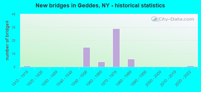
- New bridges - historical statistics
- 11910-1919
- 151950-1959
- 41960-1969
- 291970-1979
- 61980-1989
- 12020-2022
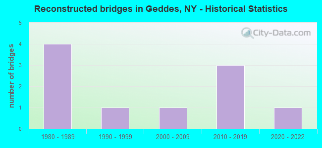
- Reconstructed bridges - Historical Statistics
- 41980-1989
- 11990-1999
- 12000-2009
- 32010-2019
- 12020-2022
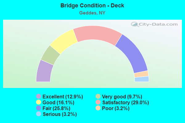
- Bridge Condition - Deck
- 12.9%Excellent
- 9.7%Very good
- 16.1%Good
- 29.0%Satisfactory
- 25.8%Fair
- 3.2%Poor
- 3.2%Serious
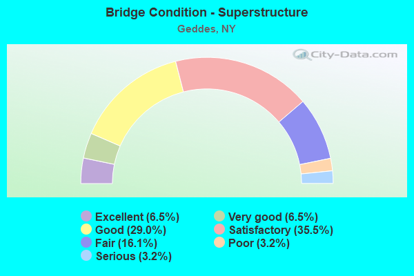
- Bridge Condition - Superstructure
- 6.5%Excellent
- 6.5%Very good
- 29.0%Good
- 35.5%Satisfactory
- 16.1%Fair
- 3.2%Poor
- 3.2%Serious
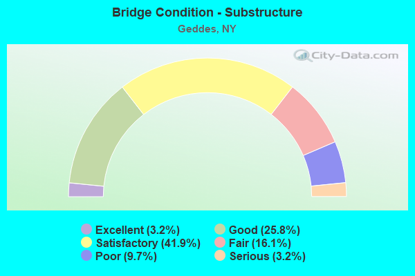
- Bridge Condition - Substructure
- 3.2%Excellent
- 25.8%Good
- 41.9%Satisfactory
- 16.1%Fair
- 9.7%Poor
- 3.2%Serious
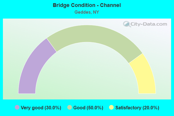
- Bridge Condition - Channel
- 30.0%Very good
- 50.0%Good
- 20.0%Satisfactory
Find on map >> Show street view
Structure Number: 1026099, Location: JCT I90 & I690 (Lat: 43.111475, Lng: -76.264433), Route carried "on" structure: State highway 690, Year Built: 1954, Year Reconstructed: 1988, Status: Open, Structure Length: 8.47m (27.79ft), Average Daily Traffic: 32,867 (year 2018), Truck Traffic: 11%, Average Future Daily Traffic: 47,410 (year 2040), Design Load: HS 20, Features Intersected: 90IX, RTE I90
Minimum Vertical Clearance: 30+ m (98+ ft), Kilometerpoint: 2.140, Lanes on structure: 5, Lanes under structure: 4, Base Highway Network: Yes, Owner: State Highway Agency, Approaching Roadway Width: 23.8m (78.1ft), Skew: 24 degrees, Material/Design: Steel, Design/Construction: Stringer/Multi-beam, Number Of Spans In Main Unit: 4, Length of Maximum Span: 26.2m (86.0ft), Curb-To-Curb Width: 27.8m (91.2ft), Out-to-Out Width: 28.9m (94.8ft)
Condition: Deck: Poor, Superstructure: Fair, Substructure: Satisfactory, Operating Rating: 33.7 metric tons, Method Used To Determine Operating Rating: Load and Resistance Factor Rating (LRFR) rating reported by rating factor(RF) method using HL-93 loadings, Inventory Rating: 25.9 metric tons, Method Used To Determine Inventory Rating: Load and Resistance Factor Rating (LRFR) rating reported by rating factor(RF) method using HL-93 loadings, Structural Evaluation: Somewhat better than minimum adequacy, Deck Geometry: Superior to present desirable criteria, Underclear: High priority of corrective action, Approach Roadway Alignment: Equal to present desirable criteria, Length Of Structure Improvement: 8.47m (27.79ft), Designated Inspection Frequency: Every 24 months, Inspection Date: November 2020, Bridge Improvement Cost: $4,887,000, Roadway Improvement Cost: $2,862,000, Total Project Cost: $7,749,000 ( Estimate for 2021), Deck Structure Type: Concrete Cast-file-Place, Wearing Surface/Protective System: Wearing Surface: Monolithic Concrete
Find on map >> Show street view
Structure Number: 104517, Location: IN SOLVAY (Lat: 43.068639, Lng: -76.217042), Route carried "on" structure: State highway 297, Year Built: 1977, Status: Open, Structure Length: 12.65m (41.50ft), Average Daily Traffic: 5,960 (year 2020), Truck Traffic: 5%, Average Future Daily Traffic: 7,374 (year 2040), Design Load: HS 20, Features Intersected: CSX TRANS/ AMTRAK
Minimum Vertical Clearance: 30+ m (98+ ft), Kilometerpoint: 3.105, Lanes on structure: 2, Base Highway Network: Yes, Owner: State Highway Agency, Approaching Roadway Width: 12.2m (40.0ft), Material/Design: Steel continuous, Design/Construction: Stringer/Multi-beam, Number Of Spans In Main Unit: 4, Length of Maximum Span: 35.0m (114.8ft), Curb or Sidewalk Widths: Left: 4.9m (16.1ft), Right: 0.0m, Curb-To-Curb Width: 8.8m (28.9ft), Out-to-Out Width: 14.5m (47.6ft)
Condition: Deck: Good, Superstructure: Fair, Substructure: Satisfactory, Operating Rating: 92.2 metric tons, Method Used To Determine Operating Rating: Field evaluation and documented engineering judgment, Inventory Rating: 32.7 metric tons, Method Used To Determine Inventory Rating: Field evaluation and documented engineering judgment, Structural Evaluation: Somewhat better than minimum adequacy, Deck Geometry: Meets minimum limits, Underclear: Somewhat better than minimum adequacy, Approach Roadway Alignment: Equal to present desirable criteria, Length Of Structure Improvement: 12.64m (41.47ft), Designated Inspection Frequency: Every 24 months, Inspection Date: July 2021, Bridge Improvement Cost: $3,919,000, Roadway Improvement Cost: $2,295,000, Total Project Cost: $6,214,000 ( Estimate for 2021), Deck Structure Type: Concrete Cast-file-Place, Wearing Surface/Protective System: Wearing Surface: Monolithic Concrete
Find on map >> Show street view
Structure Number: 1049529, Location: .6 MI SE JCT I90 & I690 (Lat: 43.106528, Lng: -76.250744), Route carried "on" structure: Interstate 690, Year Built: 1954, Year Reconstructed: 2020, Status: Open, Structure Length: 6.61m (21.69ft), Average Daily Traffic: 32,987 (year 2019), Truck Traffic: 9%, Average Future Daily Traffic: 47,583 (year 2040), Design Load: HS 20, Features Intersected: CSX TRANSPRTATION
Minimum Vertical Clearance: 30+ m (98+ ft), Kilometerpoint: 3.459, Lanes on structure: 6, Base Highway Network: Yes, Owner: State Highway Agency, Approaching Roadway Width: 34.7m (113.8ft), Skew: 24 degrees, Material/Design: Steel continuous, Design/Construction: Stringer/Multi-beam, Number Of Spans In Main Unit: 3, Length of Maximum Span: 26.2m (86.0ft), Curb-To-Curb Width: 33.9m (111.2ft), Out-to-Out Width: 35.6m (116.8ft)
Condition: Deck: Good, Superstructure: Good, Substructure: Fair, Operating Rating: 27.2 metric tons, Method Used To Determine Operating Rating: Load and Resistance Factor Rating (LRFR) rating reported by rating factor(RF) method using HL-93 loadings, Inventory Rating: 21.1 metric tons, Method Used To Determine Inventory Rating: Load and Resistance Factor Rating (LRFR) rating reported by rating factor(RF) method using HL-93 loadings, Structural Evaluation: Somewhat better than minimum adequacy, Deck Geometry: Superior to present desirable criteria, Underclear: Somewhat better than minimum adequacy, Approach Roadway Alignment: Equal to present desirable criteria, Length Of Structure Improvement: 6.61m (21.69ft), Designated Inspection Frequency: Every 24 months, Inspection Date: November 2020, Bridge Improvement Cost: $5,276,000, Roadway Improvement Cost: $3,090,000, Total Project Cost: $8,365,000 ( Estimate for 2021), Deck Structure Type: Concrete Cast-file-Place, Wearing Surface/Protective System: Wearing Surface: Epoxy Overlay, Deck Protection: Epoxy Coated Reinforcing
Find on map >> Show street view
Structure Number: 104954, Location: .7 MI SE JCT I690 & I90 (Lat: 43.106119, Lng: -76.247553), Route carried "on" structure: Interstate 690, Year Built: 1959, Status: Open, Structure Length: 1.10m (3.61ft), Average Daily Traffic: 32,987 (year 2019), Truck Traffic: 9%, Average Future Daily Traffic: 47,583 (year 2040), Design Load: H 20, Features Intersected: PARK ROAD
Minimum Vertical Clearance: 30+ m (98+ ft), Kilometerpoint: 3.717, Lanes on structure: 7, Lanes under structure: 2, Base Highway Network: Yes, Owner: State Highway Agency, Approaching Roadway Width: 16.5m (54.1ft), Skew: 20 degrees, Material/Design: Concrete, Design/Construction: Culvert, Number Of Spans In Main Unit: 1, Length of Maximum Span: 9.7m (31.8ft), Curb-To-Curb Width: 41.8m (137.1ft), Out-to-Out Width: 47.2m (154.9ft)
Condition: Culverts: Fair, Operating Rating: 65.1 metric tons, Method Used To Determine Operating Rating: Field evaluation and documented engineering judgment, Inventory Rating: 27.8 metric tons, Method Used To Determine Inventory Rating: Field evaluation and documented engineering judgment, Structural Evaluation: Somewhat better than minimum adequacy, Deck Geometry: Superior to present desirable criteria, Underclear: High priority of corrective action, Approach Roadway Alignment: Equal to present desirable criteria, Length Of Structure Improvement: 1.09m (3.58ft), Designated Inspection Frequency: Every 24 months, Inspection Date: October 2020, Bridge Improvement Cost: $3,469,000, Roadway Improvement Cost: $2,032,000, Total Project Cost: $5,501,000 ( Estimate for 2021), Wearing Surface/Protective System: Wearing Surface: Bituminous
Find on map >> Show street view
Structure Number: 104958, Location: .6 MI NW JCT I690 & SH297 (Lat: 43.079244, Lng: -76.222125), Route carried "on" structure: Ramp Interstate , Year Built: 1959, Status: Open, Structure Length: 4.85m (15.91ft), Average Daily Traffic: 50 (year 2009), Truck Traffic: 10%, Average Future Daily Traffic: 70 (year 2029), Design Load: H 20, Features Intersected: ACCESS TO PARKING, Facility Carried by Structure: RAMP R
Minimum Vertical Clearance: 30+ m (98+ ft), Kilometerpoint: 0.000, Lanes on structure: 4, Lanes under structure: 4, Owner: State Highway Agency, Approaching Roadway Width: 14.0m (45.9ft), Material/Design: Steel, Design/Construction: Stringer/Multi-beam, Number Of Spans In Main Unit: 3, Length of Maximum Span: 20.7m (67.9ft), Curb or Sidewalk Widths: Left: 2.4m (7.9ft), Right: 2.4m (7.9ft), Curb-To-Curb Width: 14.0m (45.9ft), Out-to-Out Width: 19.4m (63.6ft)
Condition: Deck: Very good, Superstructure: Very good, Substructure: Good, Operating Rating: 67.1 metric tons, Method Used To Determine Operating Rating: Load Factor (LF), Inventory Rating: 39.9 metric tons, Method Used To Determine Inventory Rating: Load Factor (LF), Structural Evaluation: Better than present minimum criteria, Deck Geometry: High priority of replacement, Underclear: Meets minimum limits, Approach Roadway Alignment: Equal to present desirable criteria, Length Of Structure Improvement: 4.84m (15.88ft), Designated Inspection Frequency: Every 24 months, Inspection Date: September 2020, Bridge Improvement Cost: $1,919,000, Roadway Improvement Cost: $1,124,000, Total Project Cost: $3,042,000 ( Estimate for 2021), Deck Structure Type: Concrete Cast-file-Place, Wearing Surface/Protective System: Wearing Surface: Monolithic Concrete
Find on map >> Show street view
Structure Number: 10496, Location: .2 MI NW JCT I690 & SH297 (Lat: 43.075539, Lng: -76.216631), Route carried "on" structure: Ramp Other road , Year Built: 1959, Status: Open, Structure Length: 4.97m (16.31ft), Average Daily Traffic: 50 (year 2009), Truck Traffic: 10%, Average Future Daily Traffic: 70 (year 2029), Design Load: H 20, Features Intersected: STATE FAIR PARKNG, Facility Carried by Structure: RAMP N
Minimum Vertical Clearance: 30+ m (98+ ft), Kilometerpoint: 0.000, Lanes on structure: 4, Lanes under structure: 4, Owner: State Highway Agency, Approaching Roadway Width: 14.0m (45.9ft), Material/Design: Steel, Design/Construction: Stringer/Multi-beam, Number Of Spans In Main Unit: 3, Length of Maximum Span: 20.7m (67.9ft), Curb or Sidewalk Widths: Left: 2.4m (7.9ft), Right: 2.4m (7.9ft), Curb-To-Curb Width: 14.0m (45.9ft), Out-to-Out Width: 19.4m (63.6ft)
Condition: Deck: Good, Superstructure: Very good, Substructure: Satisfactory, Operating Rating: 68.0 metric tons, Method Used To Determine Operating Rating: Load Factor (LF), Inventory Rating: 40.8 metric tons, Method Used To Determine Inventory Rating: Load Factor (LF), Structural Evaluation: Equal to present minimum criteria, Deck Geometry: High priority of replacement, Underclear: Meets minimum limits, Approach Roadway Alignment: Equal to present desirable criteria, Length Of Structure Improvement: 4.96m (16.27ft), Designated Inspection Frequency: Every 24 months, Inspection Date: September 2020, Bridge Improvement Cost: $1,940,000, Roadway Improvement Cost: $1,136,000, Total Project Cost: $3,077,000 ( Estimate for 2021), Deck Structure Type: Concrete Cast-file-Place, Wearing Surface/Protective System: Wearing Surface: Monolithic Concrete
Find on map >> Show street view
Structure Number: 1061731, Location: EXIT 4 OF I690 (Lat: 43.112794, Lng: -76.267378), Route carried "on" structure: Interstate 690, Year Built: 1971, Year Reconstructed: 1988, Status: Open, Structure Length: 3.20m (10.50ft), Average Daily Traffic: 11,439 (year 2018), Truck Traffic: 11%, Average Future Daily Traffic: 16,500 (year 2040), Design Load: HS 20, Features Intersected: JN GLN RMP E-CR81
Minimum Vertical Clearance: 30+ m (98+ ft), Kilometerpoint: 1.915, Lanes on structure: 2, Lanes under structure: 2, Base Highway Network: Yes, Owner: State Highway Agency, Approaching Roadway Width: 11.6m (38.1ft), Skew: 2 degrees, Material/Design: Steel, Design/Construction: Stringer/Multi-beam, Number Of Spans In Main Unit: 1, Length of Maximum Span: 31.0m (101.7ft), Curb-To-Curb Width: 11.4m (37.4ft), Out-to-Out Width: 12.4m (40.7ft)
Condition: Deck: Good, Superstructure: Good, Substructure: Satisfactory, Operating Rating: 80.7 metric tons, Method Used To Determine Operating Rating: Load Factor (LF), Inventory Rating: 48.1 metric tons, Method Used To Determine Inventory Rating: Load Factor (LF), Structural Evaluation: Equal to present minimum criteria, Deck Geometry: Somewhat better than minimum adequacy, Underclear: High priority of corrective action, Approach Roadway Alignment: Equal to present desirable criteria, Length Of Structure Improvement: 3.20m (10.50ft), Designated Inspection Frequency: Every 24 months, Inspection Date: May 2020, Bridge Improvement Cost: $1,102,000, Roadway Improvement Cost: $645,000, Total Project Cost: $1,747,000 ( Estimate for 2021), Deck Structure Type: Concrete Cast-file-Place, Wearing Surface/Protective System: Wearing Surface: Integral Concrete, Deck Protection: Epoxy Coated Reinforcing
Find on map >> Show street view
Structure Number: 1061732, Location: .1 MI NW JCT I690 NB & I9 (Lat: 43.112878, Lng: -76.267258), Route carried "on" structure: State highway 690, Year Built: 1971, Year Reconstructed: 1988, Status: Open, Structure Length: 3.26m (10.70ft), Average Daily Traffic: 15,408 (year 2002), Truck Traffic: 13%, Design Load: HS 20, Features Intersected: JOHN GLENN RAMP E
Minimum Vertical Clearance: 30+ m (98+ ft), Kilometerpoint: 1.915, Lanes on structure: 2, Lanes under structure: 2, Base Highway Network: Yes, Owner: State Highway Agency, Approaching Roadway Width: 13.1m (43.0ft), Skew: 2 degrees, Material/Design: Steel, Design/Construction: Stringer/Multi-beam, Number Of Spans In Main Unit: 1, Length of Maximum Span: 30.7m (100.7ft), Curb or Sidewalk Widths: Left: 0.5m (1.6ft), Right: 0.5m (1.6ft), Curb-To-Curb Width: 13.0m (42.7ft), Out-to-Out Width: 14.0m (45.9ft)
Condition: Deck: Good, Superstructure: Satisfactory, Substructure: Satisfactory, Operating Rating: 59.9 metric tons, Method Used To Determine Operating Rating: Load Factor (LF), Inventory Rating: 35.4 metric tons, Method Used To Determine Inventory Rating: Load Factor (LF), Structural Evaluation: Equal to present minimum criteria, Deck Geometry: Superior to present desirable criteria, Underclear: Meets minimum limits, Approach Roadway Alignment: Equal to present desirable criteria, Length Of Structure Improvement: 3.26m (10.70ft), Designated Inspection Frequency: Every 24 months, Inspection Date: May 2020, Bridge Improvement Cost: $1,325,000, Roadway Improvement Cost: $776,000, Total Project Cost: $2,101,000 ( Estimate for 2021), Deck Structure Type: Concrete Cast-file-Place, Wearing Surface/Protective System: Wearing Surface: Integral Concrete, Deck Protection: Epoxy Coated Reinforcing
Find on map >> Show street view
Structure Number: 107289, Location: IN GEDDES-ONON LAKE CO PK (Lat: 43.107117, Lng: -76.251472), Route carried "on" structure: Ramp Interstate , Year Built: 1987, Status: Open, Structure Length: 3.90m (12.80ft), Average Daily Traffic: 1,358 (year 2017), Truck Traffic: 9%, Average Future Daily Traffic: 1,958 (year 2040), Design Load: HS 20, Features Intersected: CSX TRANSPRTATION, Facility Carried by Structure: I690 WB OFF RAMP T
Minimum Vertical Clearance: 30+ m (98+ ft), Kilometerpoint: 0.338, Lanes on structure: 1, Owner: State Highway Agency, Approaching Roadway Width: 7.6m (24.9ft), Skew: 6 degrees, Material/Design: Steel, Design/Construction: Stringer/Multi-beam, Number Of Spans In Main Unit: 1, Length of Maximum Span: 35.6m (116.8ft), Curb-To-Curb Width: 7.4m (24.3ft), Out-to-Out Width: 8.5m (27.9ft)
Condition: Deck: Satisfactory, Superstructure: Good, Substructure: Satisfactory, Inventory Rating: 70.8 metric tons, Method Used To Determine Inventory Rating: Load Factor (LF), Structural Evaluation: Equal to present minimum criteria, Deck Geometry: Better than present minimum criteria, Underclear: Equal to present minimum criteria, Approach Roadway Alignment: Equal to present desirable criteria, Length Of Structure Improvement: 3.90m (12.80ft), Designated Inspection Frequency: Every 24 months, Inspection Date: June 2021, Bridge Improvement Cost: $908,000, Roadway Improvement Cost: $531,000, Total Project Cost: $1,439,000 ( Estimate for 2021), Deck Structure Type: Concrete Cast-file-Place, Wearing Surface/Protective System: Wearing Surface: Integral Concrete, Deck Protection: Epoxy Coated Reinforcing
Find on map >> Show street view
Structure Number: 10729, Location: IN GEDDES-ONON LAKE CO PK (Lat: 43.105783, Lng: -76.249847), Route carried "on" structure: Ramp Interstate , Year Built: 1987, Status: Open, Structure Length: 1.49m (4.89ft), Average Daily Traffic: 1,302 (year 2017), Truck Traffic: 8%, Average Future Daily Traffic: 1,878 (year 2040), Design Load: HS 20, Features Intersected: CSX TRANSPRTATION, Facility Carried by Structure: FROM STATE FAIR BL
Minimum Vertical Clearance: 30+ m (98+ ft), Kilometerpoint: 0.225, Lanes on structure: 1, Owner: State Highway Agency, Approaching Roadway Width: 7.6m (24.9ft), Skew: 1 degrees, Material/Design: Prestressed concrete, Design/Construction: Box Beam or Girders - Multiple, Number Of Spans In Main Unit: 1, Length of Maximum Span: 13.7m (44.9ft), Curb-To-Curb Width: 7.6m (24.9ft), Out-to-Out Width: 8.6m (28.2ft)
Condition: Deck: Fair, Superstructure: Satisfactory, Substructure: Satisfactory, Operating Rating: 38.9 metric tons, Method Used To Determine Operating Rating: Load and Resistance Factor Rating (LRFR) rating reported by rating factor(RF) method using HL-93 loadings, Inventory Rating: 29.8 metric tons, Method Used To Determine Inventory Rating: Load and Resistance Factor Rating (LRFR) rating reported by rating factor(RF) method using HL-93 loadings, Structural Evaluation: Equal to present minimum criteria, Deck Geometry: Better than present minimum criteria, Underclear: Somewhat better than minimum adequacy, Approach Roadway Alignment: Equal to present desirable criteria, Length Of Structure Improvement: 1.49m (4.89ft), Designated Inspection Frequency: Every 24 months, Inspection Date: June 2021, Bridge Improvement Cost: $333,000, Roadway Improvement Cost: $195,000, Total Project Cost: $528,000 ( Estimate for 2021), Deck Structure Type: Concrete Cast-file-Place, Wearing Surface/Protective System: Wearing Surface: Integral Concrete
Find on map >> Show street view
Structure Number: 107291, Location: 0.6 mi E I90 & I690 (Lat: 43.106839, Lng: -76.253606), Route carried "on" structure: Interstate 690, Year Built: 1987, Status: Open, Structure Length: 4.85m (15.91ft), Average Daily Traffic: 32,867 (year 2018), Truck Traffic: 8%, Average Future Daily Traffic: 47,410 (year 2040), Design Load: HS 20, Features Intersected: CR80 ST FAIR BLVD
Minimum Vertical Clearance: 30+ m (98+ ft), Kilometerpoint: 3.218, Lanes on structure: 7, Lanes under structure: 2, Base Highway Network: Yes, Owner: State Highway Agency, Approaching Roadway Width: 38.1m (125.0ft), Skew: 26 degrees, Material/Design: Steel, Design/Construction: Stringer/Multi-beam, Number Of Spans In Main Unit: 1, Length of Maximum Span: 46.9m (153.9ft), Curb-To-Curb Width: 38.1m (125.0ft), Out-to-Out Width: 39.0m (128.0ft)
Condition: Deck: Satisfactory, Superstructure: Satisfactory, Substructure: Poor, Inventory Rating: 63.5 metric tons, Method Used To Determine Inventory Rating: Load Factor (LF), Structural Evaluation: Meets minimum limits, Deck Geometry: Superior to present desirable criteria, Underclear: Equal to present minimum criteria, Approach Roadway Alignment: Equal to present desirable criteria, Length Of Structure Improvement: 4.84m (15.88ft), Designated Inspection Frequency: Every 24 months, Inspection Date: June 2021, Bridge Improvement Cost: $5,904,000, Roadway Improvement Cost: $3,457,000, Total Project Cost: $9,361,000 ( Estimate for 2021), Deck Structure Type: Concrete Cast-file-Place, Wearing Surface/Protective System: Wearing Surface: Integral Concrete, Deck Protection: Epoxy Coated Reinforcing
Find on map >> Show street view
Structure Number: 107315, Location: 0.3MI E INTRCH 39 OVR 90I (Lat: 43.111489, Lng: -76.265386), Route carried "on" structure: Ramp Interstate , Year Built: 1987, Status: Open, Structure Length: 7.80m (25.59ft), Average Daily Traffic: 6,842 (year 2017), Truck Traffic: 4%, Average Future Daily Traffic: 9,869 (year 2040), Design Load: HS 20, Features Intersected: 90IX WB, RTE I90, Facility Carried by Structure: FR.RTE 48 TO 690I
Minimum Vertical Clearance: 30+ m (98+ ft), Kilometerpoint: 0.708, Lanes on structure: 2, Lanes under structure: 4, Owner: State Highway Agency, Approaching Roadway Width: 12.2m (40.0ft), Skew: 4 degrees, Material/Design: Steel continuous, Design/Construction: Stringer/Multi-beam, Number Of Spans In Main Unit: 2, Length of Maximum Span: 38.1m (125.0ft), Curb-To-Curb Width: 12.0m (39.4ft), Out-to-Out Width: 13.0m (42.7ft)
Condition: Deck: Satisfactory, Superstructure: Satisfactory, Substructure: Fair, Operating Rating: 86.2 metric tons, Method Used To Determine Operating Rating: Load Factor (LF), Inventory Rating: 51.7 metric tons, Method Used To Determine Inventory Rating: Load Factor (LF), Structural Evaluation: Somewhat better than minimum adequacy, Deck Geometry: Superior to present desirable criteria, Underclear: Equal to present minimum criteria, Approach Roadway Alignment: Equal to present desirable criteria, Length Of Structure Improvement: 7.80m (25.59ft), Designated Inspection Frequency: Every 24 months, Inspection Date: October 2021, Bridge Improvement Cost: $2,142,000, Roadway Improvement Cost: $1,254,000, Total Project Cost: $3,396,000 ( Estimate for 2021), Deck Structure Type: Concrete Cast-file-Place, Wearing Surface/Protective System: Wearing Surface: Integral Concrete, Deck Protection: Epoxy Coated Reinforcing
Find on map >> Show street view
Structure Number: 107799, Location: 0,3 MI SE JCT RT 690I+695 (Lat: 43.081706, Lng: -76.223058), Route carried "on" structure: Ramp Other road , Year Built: 2020, Status: Open, Structure Length: 7.74m (25.39ft), Truck Traffic: 14%, Design Load: HL 93, Features Intersected: I690 WB, I690 EB, Facility Carried by Structure: I690 EB RAMP
Minimum Vertical Clearance: 32.69m (107.25ft), Kilometerpoint: 0.097, Lanes on structure: 1, Lanes under structure: 4, Owner: State Highway Agency, Approaching Roadway Width: 6.7m (22.0ft), Skew: 20 degrees, Material/Design: Steel, Design/Construction: Stringer/Multi-beam, Number Of Spans In Main Unit: 2, Length of Maximum Span: 38.7m (127.0ft), Curb or Sidewalk Widths: Left: 3.0m (9.8ft), Right: 0.0m, Curb-To-Curb Width: 6.7m (22.0ft), Out-to-Out Width: 11.3m (37.1ft)
Condition: Deck: Excellent, Superstructure: Excellent, Substructure: Excellent, Inventory Rating: 40.8 metric tons, Method Used To Determine Inventory Rating: Field evaluation and documented engineering judgment, Structural Evaluation: Superior to present desirable criteria, Deck Geometry: Equal to present minimum criteria, Underclear: Meets minimum limits, Approach Roadway Alignment: Equal to present desirable criteria, Length Of Structure Improvement: 7.74m (25.39ft), Designated Inspection Frequency: Every 24 months, Inspection Date: October 2020, Bridge Improvement Cost: $1,977,000, Roadway Improvement Cost: $1,158,000, Total Project Cost: $3,135,000 ( Estimate for 2021), Deck Structure Type: Concrete Cast-file-Place, Wearing Surface/Protective System: Wearing Surface: Integral Concrete, Deck Protection: Epoxy Coated Reinforcing
Find on map >> Show street view
Structure Number: 109328, Location: RAMP-RTE 5 CONN. TO I-690 (Lat: 43.080639, Lng: -76.225847), Route carried "on" structure: Ramp State highway , Year Built: 1975, Status: Open, Structure Length: 62.64m (205.51ft), Average Daily Traffic: 5,262 (year 2017), Truck Traffic: 6%, Average Future Daily Traffic: 7,590 (year 2040), Design Load: HS 20, Features Intersected: 695 695 3301 1018 NB, ST, Facility Carried by Structure: RAMP TO I-690 WB
Minimum Vertical Clearance: 30+ m (98+ ft), Kilometerpoint: 0.531, Lanes on structure: 1, Lanes under structure: 11, Owner: State Highway Agency, Approaching Roadway Width: 8.8m (28.9ft), Skew: 3 degrees, Material/Design: Steel, Design/Construction: Stringer/Multi-beam, Number Of Spans In Main Unit: 14, Length of Maximum Span: 53.0m (173.9ft), Curb-To-Curb Width: 8.8m (28.9ft), Out-to-Out Width: 9.8m (32.2ft)
Condition: Deck: Satisfactory, Superstructure: Fair, Substructure: Poor, Operating Rating: 74.4 metric tons, Method Used To Determine Operating Rating: Load Factor (LF), Inventory Rating: 32.7 metric tons, Method Used To Determine Inventory Rating: Load Factor (LF), Structural Evaluation: Meets minimum limits, Deck Geometry: Superior to present desirable criteria, Underclear: High priority of corrective action, Waterway Adequacy: Superior to present desirable criteria, Approach Roadway Alignment: Equal to present desirable criteria, Length Of Structure Improvement: 62.63m (205.48ft), Designated Inspection Frequency: Every 24 months, Inspection Date: August 2021, Bridge Improvement Cost: $11,706,000, Roadway Improvement Cost: $6,855,000, Total Project Cost: $18,561,000 ( Estimate for 2021), Deck Structure Type: Concrete Cast-file-Place, Wearing Surface/Protective System: Wearing Surface: Integral Concrete
Find on map >> Show street view
Structure Number: 109328A, Location: STATE FAIR BLVD TO I690WB (Lat: 43.082350, Lng: -76.225736), Route carried "on" structure: Ramp State highway , Year Built: 1975, Status: Open, Structure Length: 8.53m (27.99ft), Average Daily Traffic: 799 (year 2017), Truck Traffic: 20%, Average Future Daily Traffic: 1,152 (year 2040), Design Load: HS 20, Features Intersected: NINE MILE CREEK, Facility Carried by Structure: RAMP T
Minimum Vertical Clearance: 30+ m (98+ ft), Kilometerpoint: 0.338, Lanes on structure: 1, Owner: State Highway Agency, Approaching Roadway Width: 7.3m (24.0ft), Skew: 2 degrees, Material/Design: Steel, Design/Construction: Stringer/Multi-beam, Number Of Spans In Main Unit: 3, Length of Maximum Span: 33.2m (108.9ft), Curb-To-Curb Width: 7.3m (24.0ft), Out-to-Out Width: 8.2m (26.9ft)
Condition: Deck: Fair, Superstructure: Satisfactory, Substructure: Good, Channel: Good, Operating Rating: 87.5 metric tons, Method Used To Determine Operating Rating: Field evaluation and documented engineering judgment, Inventory Rating: 32.7 metric tons, Method Used To Determine Inventory Rating: Field evaluation and documented engineering judgment, Structural Evaluation: Equal to present minimum criteria, Deck Geometry: Better than present minimum criteria, Waterway Adequacy: Equal to present minimum criteria, Approach Roadway Alignment: Equal to present desirable criteria, Length Of Structure Improvement: 8.53m (27.99ft), Designated Inspection Frequency: Every 24 months, Inspection Date: June 2021, Bridge Improvement Cost: $1,388,000, Roadway Improvement Cost: $813,000, Total Project Cost: $2,201,000 ( Estimate for 2021), Deck Structure Type: Concrete Cast-file-Place, Wearing Surface/Protective System: Wearing Surface: Integral Concrete
Find on map >> Show street view
Structure Number: 109329, Location: S RAMP TO RTE 5 CONN. SB (Lat: 43.081431, Lng: -76.226353), Route carried "on" structure: Ramp State highway 930T, Year Built: 1975, Status: Open, Structure Length: 20.39m (66.90ft), Average Daily Traffic: 4,913 (year 2017), Truck Traffic: 5%, Average Future Daily Traffic: 7,087 (year 2040), Design Load: HS 20, Features Intersected: COUNTY ROAD 80, NINE MIL
Minimum Vertical Clearance: 30+ m (98+ ft), Kilometerpoint: 0.434, Lanes on structure: 1, Lanes under structure: 3, Owner: State Highway Agency, Approaching Roadway Width: 10.1m (33.1ft), Skew: 1 degrees, Material/Design: Steel, Design/Construction: Stringer/Multi-beam, Number Of Spans In Main Unit: 5, Length of Maximum Span: 43.2m (141.7ft), Curb-To-Curb Width: 9.8m (32.2ft), Out-to-Out Width: 10.7m (35.1ft)
Condition: Deck: Fair, Superstructure: Satisfactory, Substructure: Poor, Channel: Satisfactory, Operating Rating: 81.6 metric tons, Method Used To Determine Operating Rating: Load Factor (LF), Inventory Rating: 43.5 metric tons, Method Used To Determine Inventory Rating: Load Factor (LF), Structural Evaluation: Meets minimum limits, Deck Geometry: Superior to present desirable criteria, Underclear: Meets minimum limits, Waterway Adequacy: Superior to present desirable criteria, Approach Roadway Alignment: Equal to present desirable criteria, Length Of Structure Improvement: 20.39m (66.90ft), Designated Inspection Frequency: Every 24 months, Inspection Date: August 2021, Bridge Improvement Cost: $4,266,000, Roadway Improvement Cost: $2,498,000, Total Project Cost: $6,763,000 ( Estimate for 2021), Deck Structure Type: Concrete Cast-file-Place, Wearing Surface/Protective System: Wearing Surface: Integral Concrete
Find on map >> Show street view
Structure Number: 109331, Location: I690 WB TO SH 5 CONN SB (Lat: 43.080894, Lng: -76.220722), Route carried "on" structure: Spur State highway 695, Year Built: 1975, Status: Open, Structure Length: 46.94m (154.00ft), Average Daily Traffic: 12,255 (year 2011), Truck Traffic: 14%, Average Future Daily Traffic: 17,677 (year 2040), Design Load: HS 20, Features Intersected: 690I690I33011018, State
Minimum Vertical Clearance: 30+ m (98+ ft), Kilometerpoint: 1.512, Lanes on structure: 2, Lanes under structure: 10, Owner: State Highway Agency, Approaching Roadway Width: 12.5m (41.0ft), Skew: 2 degrees, Material/Design: Steel, Design/Construction: Stringer/Multi-beam, Number Of Spans In Main Unit: 13, Length of Maximum Span: 51.2m (168.0ft), Curb-To-Curb Width: 12.5m (41.0ft), Out-to-Out Width: 13.4m (44.0ft)
Condition: Deck: Satisfactory, Superstructure: Satisfactory, Substructure: Fair, Operating Rating: 68.9 metric tons, Method Used To Determine Operating Rating: Load Factor (LF), Inventory Rating: 34.5 metric tons, Method Used To Determine Inventory Rating: Load Factor (LF), Structural Evaluation: Somewhat better than minimum adequacy, Deck Geometry: Better than present minimum criteria, Underclear: High priority of corrective action, Approach Roadway Alignment: Equal to present desirable criteria, Length Of Structure Improvement: 46.93m (153.97ft), Designated Inspection Frequency: Every 24 months, Inspection Date: December 2020, Bridge Improvement Cost: $11,740,000, Roadway Improvement Cost: $6,875,000, Total Project Cost: $18,615,000 ( Estimate for 2021), Deck Structure Type: Concrete Cast-file-Place, Wearing Surface/Protective System: Wearing Surface: Integral Concrete
Find on map >> Show street view
Structure Number: 109331A, Location: 2.3 MI SE EXIT 39 OF I90 (Lat: 43.079931, Lng: -76.224600), Route carried "on" structure: Ramp State highway 931B, Year Built: 1975, Status: Open, Structure Length: 9.78m (32.09ft), Average Daily Traffic: 4,395 (year 2010), Truck Traffic: 14%, Average Future Daily Traffic: 6,339 (year 2040), Design Load: HS 20, Features Intersected: RELIEF
Minimum Vertical Clearance: 30+ m (98+ ft), Kilometerpoint: 0.370, Lanes on structure: 1, Owner: State Highway Agency, Approaching Roadway Width: 8.5m (27.9ft), Material/Design: Steel, Design/Construction: Stringer/Multi-beam, Number Of Spans In Main Unit: 3, Length of Maximum Span: 33.2m (108.9ft), Curb-To-Curb Width: 7.6m (24.9ft), Out-to-Out Width: 8.5m (27.9ft)
Condition: Deck: Very good, Superstructure: Good, Substructure: Good, Operating Rating: 71.7 metric tons, Method Used To Determine Operating Rating: Load Factor (LF), Inventory Rating: 39.0 metric tons, Method Used To Determine Inventory Rating: Load Factor (LF), Structural Evaluation: Better than present minimum criteria, Deck Geometry: Better than present minimum criteria, Approach Roadway Alignment: Equal to present desirable criteria, Length Of Structure Improvement: 9.78m (32.09ft), Designated Inspection Frequency: Every 24 months, Inspection Date: October 2020, Bridge Improvement Cost: $1,595,000, Roadway Improvement Cost: $934,000, Total Project Cost: $2,529,000 ( Estimate for 2021), Deck Structure Type: Concrete Cast-file-Place, Wearing Surface/Protective System: Wearing Surface: Integral Concrete
Find on map >> Show street view
Structure Number: 109332, Location: SH 5 CONN TO I690 EB (Lat: 43.079681, Lng: -76.224553), Route carried "on" structure: Spur State highway 695, Year Built: 1975, Status: Open, Structure Length: 17.01m (55.81ft), Truck Traffic: 7%, Design Load: HS 20, Features Intersected: CR 80, CSX RR
Minimum Vertical Clearance: 30+ m (98+ ft), Kilometerpoint: 3.282, Lanes on structure: 2, Lanes under structure: 4, Base Highway Network: Yes, Owner: State Highway Agency, Approaching Roadway Width: 12.8m (42.0ft), Skew: 1 degrees, Material/Design: Steel, Design/Construction: Stringer/Multi-beam, Number Of Spans In Main Unit: 5, Length of Maximum Span: 39.0m (128.0ft), Curb-To-Curb Width: 12.6m (41.3ft), Out-to-Out Width: 13.4m (44.0ft)
Condition: Deck: Fair, Superstructure: Fair, Substructure: Fair, Operating Rating: 83.5 metric tons, Method Used To Determine Operating Rating: Load Factor (LF), Inventory Rating: 44.5 metric tons, Method Used To Determine Inventory Rating: Load Factor (LF), Structural Evaluation: Somewhat better than minimum adequacy, Deck Geometry: Better than present minimum criteria, Underclear: Equal to present minimum criteria, Approach Roadway Alignment: Equal to present desirable criteria, Length Of Structure Improvement: 17.00m (55.77ft), Designated Inspection Frequency: Every 24 months, Inspection Date: December 2020, Bridge Improvement Cost: $4,384,000, Roadway Improvement Cost: $2,568,000, Total Project Cost: $6,952,000 ( Estimate for 2021), Deck Structure Type: Concrete Cast-file-Place, Wearing Surface/Protective System: Wearing Surface: Integral Concrete
Find on map >> Show street view
Structure Number: 1093331, Location: I-690 WB + NINE MI CREEK (Lat: 43.082814, Lng: -76.225200), Route carried "on" structure: Spur Interstate 690, Year Built: 1975, Status: Open, Structure Length: 2.80m (9.19ft), Average Daily Traffic: 25,881 (year 2009), Truck Traffic: 11%, Design Load: HS 20, Features Intersected: NINE MILE CREEK
Minimum Vertical Clearance: 30+ m (98+ ft), Kilometerpoint: 6.935, Lanes on structure: 2, Base Highway Network: Yes, Owner: State Highway Agency, Approaching Roadway Width: 12.5m (41.0ft), Material/Design: Prestressed concrete, Design/Construction: Stringer/Multi-beam, Number Of Spans In Main Unit: 1, Length of Maximum Span: 27.4m (89.9ft), Curb-To-Curb Width: 12.6m (41.3ft), Out-to-Out Width: 13.5m (44.3ft)
Condition: Deck: Satisfactory, Superstructure: Good, Substructure: Satisfactory, Channel: Very good, Operating Rating: 89.8 metric tons, Method Used To Determine Operating Rating: Load Factor (LF), Inventory Rating: 32.7 metric tons, Method Used To Determine Inventory Rating: Load Factor (LF), Structural Evaluation: Equal to present minimum criteria, Deck Geometry: Better than present minimum criteria, Waterway Adequacy: Equal to present desirable criteria, Approach Roadway Alignment: Equal to present desirable criteria, Length Of Structure Improvement: 2.80m (9.19ft), Designated Inspection Frequency: Every 24 months, Inspection Date: June 2020, Bridge Improvement Cost: $1,501,000, Roadway Improvement Cost: $879,000, Total Project Cost: $2,380,000 ( Estimate for 2021), Deck Structure Type: Concrete Cast-file-Place, Wearing Surface/Protective System: Wearing Surface: Integral Concrete
Find on map >> Show street view
Structure Number: 1093332, Location: I-690 EB + NINE MI CREEK (Lat: 43.082594, Lng: -76.225450), Route carried "on" structure: Spur Interstate 690, Year Built: 1975, Status: Open, Structure Length: 2.80m (9.19ft), Truck Traffic: 11%, Design Load: HS 20, Features Intersected: NINE MILE CREEK
Minimum Vertical Clearance: 30+ m (98+ ft), Kilometerpoint: 6.935, Lanes on structure: 2, Base Highway Network: Yes, Owner: State Highway Agency, Approaching Roadway Width: 12.5m (41.0ft), Material/Design: Prestressed concrete, Design/Construction: Stringer/Multi-beam, Number Of Spans In Main Unit: 1, Length of Maximum Span: 27.4m (89.9ft), Curb-To-Curb Width: 12.6m (41.3ft), Out-to-Out Width: 13.5m (44.3ft)
Condition: Deck: Fair, Superstructure: Good, Substructure: Satisfactory, Channel: Very good, Operating Rating: 89.8 metric tons, Method Used To Determine Operating Rating: Load Factor (LF), Inventory Rating: 32.7 metric tons, Method Used To Determine Inventory Rating: Load Factor (LF), Structural Evaluation: Equal to present minimum criteria, Deck Geometry: Better than present minimum criteria, Waterway Adequacy: Equal to present desirable criteria, Approach Roadway Alignment: Equal to present desirable criteria, Length Of Structure Improvement: 2.80m (9.19ft), Designated Inspection Frequency: Every 24 months, Inspection Date: June 2020, Bridge Improvement Cost: $1,569,000, Roadway Improvement Cost: $919,000, Total Project Cost: $2,487,000 ( Estimate for 2021), Deck Structure Type: Concrete Cast-file-Place, Wearing Surface/Protective System: Wearing Surface: Integral Concrete
Find on map >> Show street view
Structure Number: 1093351, Location: JCT OF I690 WB & SH 297 (Lat: 43.072433, Lng: -76.207658), Route carried "on" structure: Interstate 690, Year Built: 1975, Status: Open, Structure Length: 3.84m (12.60ft), Average Daily Traffic: 38,721 (year 2005), Truck Traffic: 13%, Design Load: HS 20, Features Intersected: RAMP TO CR 80
Minimum Vertical Clearance: 30+ m (98+ ft), Kilometerpoint: 8.753, Lanes on structure: 3, Lanes under structure: 3, Base Highway Network: Yes, Owner: State Highway Agency, Approaching Roadway Width: 16.2m (53.1ft), Skew: 3 degrees, Material/Design: Steel, Design/Construction: Stringer/Multi-beam, Number Of Spans In Main Unit: 1, Length of Maximum Span: 37.7m (123.7ft), Curb-To-Curb Width: 16.2m (53.1ft), Out-to-Out Width: 17.1m (56.1ft)
Condition: Deck: Fair, Superstructure: Good, Substructure: Good, Operating Rating: 81.6 metric tons, Method Used To Determine Operating Rating: Load Factor (LF), Inventory Rating: 49.0 metric tons, Method Used To Determine Inventory Rating: Load Factor (LF), Structural Evaluation: Better than present minimum criteria, Deck Geometry: Equal to present minimum criteria, Underclear: Equal to present minimum criteria, Approach Roadway Alignment: Equal to present desirable criteria, Length Of Structure Improvement: 3.84m (12.60ft), Designated Inspection Frequency: Every 24 months, Inspection Date: May 2020, Bridge Improvement Cost: $2,045,000, Roadway Improvement Cost: $1,198,000, Total Project Cost: $3,243,000 ( Estimate for 2021), Deck Structure Type: Concrete Cast-file-Place, Wearing Surface/Protective System: Wearing Surface: Integral Concrete
Find on map >> Show street view
Structure Number: 1093352, Location: JCT OF I690 EB & SH 297 (Lat: 43.072339, Lng: -76.207956), Route carried "on" structure: Interstate 690, Year Built: 1975, Status: Open, Structure Length: 3.84m (12.60ft), Average Daily Traffic: 25,816 (year 2018), Truck Traffic: 6%, Average Future Daily Traffic: 37,239 (year 2040), Design Load: HS 20, Features Intersected: RAMP TO CR 80
Minimum Vertical Clearance: 30+ m (98+ ft), Kilometerpoint: 8.753, Lanes on structure: 3, Lanes under structure: 3, Base Highway Network: Yes, Owner: State Highway Agency, Approaching Roadway Width: 16.2m (53.1ft), Skew: 3 degrees, Material/Design: Steel, Design/Construction: Stringer/Multi-beam, Number Of Spans In Main Unit: 1, Length of Maximum Span: 37.7m (123.7ft), Curb-To-Curb Width: 16.2m (53.1ft), Out-to-Out Width: 17.1m (56.1ft)
Condition: Deck: Fair, Superstructure: Good, Substructure: Fair, Operating Rating: 77.1 metric tons, Method Used To Determine Operating Rating: Load Factor (LF), Inventory Rating: 40.8 metric tons, Method Used To Determine Inventory Rating: Load Factor (LF), Structural Evaluation: Somewhat better than minimum adequacy, Deck Geometry: Equal to present minimum criteria, Underclear: Superior to present desirable criteria, Approach Roadway Alignment: Equal to present desirable criteria, Length Of Structure Improvement: 3.84m (12.60ft), Designated Inspection Frequency: Every 24 months, Inspection Date: May 2020, Bridge Improvement Cost: $2,046,000, Roadway Improvement Cost: $1,198,000, Total Project Cost: $3,245,000 ( Estimate for 2021), Deck Structure Type: Concrete Cast-file-Place, Wearing Surface/Protective System: Wearing Surface: Integral Concrete
Find on map >> Show street view
Structure Number: 109336, Location: OFF RAMP-690EB+NINE MI CR (Lat: 43.078261, Lng: -76.227683), Route carried "on" structure: Ramp Other road , Year Built: 1975, Status: Open, Structure Length: 2.87m (9.42ft), Average Daily Traffic: 114 (year 2011), Truck Traffic: 4%, Average Future Daily Traffic: 160 (year 2031), Design Load: HS 20, Features Intersected: NINE MILE CREEK, Facility Carried by Structure: ROADWAY SO
Minimum Vertical Clearance: 30+ m (98+ ft), Kilometerpoint: 0.193, Lanes on structure: 1, Owner: State Highway Agency, Approaching Roadway Width: 10.1m (33.1ft), Skew: 1 degrees, Material/Design: Steel, Design/Construction: Stringer/Multi-beam, Number Of Spans In Main Unit: 1, Length of Maximum Span: 28.0m (91.9ft), Curb-To-Curb Width: 10.1m (33.1ft), Out-to-Out Width: 11.0m (36.1ft)
Condition: Deck: Fair, Superstructure: Fair, Substructure: Good, Channel: Good, Operating Rating: 89.8 metric tons, Method Used To Determine Operating Rating: Load Factor (LF), Inventory Rating: 32.7 metric tons, Method Used To Determine Inventory Rating: Load Factor (LF), Structural Evaluation: Somewhat better than minimum adequacy, Deck Geometry: Superior to present desirable criteria, Waterway Adequacy: Equal to present minimum criteria, Approach Roadway Alignment: Equal to present minimum criteria, Length Of Structure Improvement: 2.86m (9.38ft), Designated Inspection Frequency: Every 24 months, Inspection Date: May 2020, Bridge Improvement Cost: $881,000, Roadway Improvement Cost: $516,000, Total Project Cost: $1,397,000 ( Estimate for 2021), Deck Structure Type: Concrete Cast-file-Place, Wearing Surface/Protective System: Wearing Surface: Integral Concrete
Find on map >> Show street view
Structure Number: 1093389, Location: JCT SH 695 & CSX RR M.LIN (Lat: 43.072489, Lng: -76.232544), Route carried "on" structure: Spur State highway 695, Year Built: 1975, Status: Open, Structure Length: 24.75m (81.20ft), Average Daily Traffic: 38,213 (year 2020), Truck Traffic: 4%, Average Future Daily Traffic: 49,783 (year 2040), Design Load: HS 20, Features Intersected: CSX RR / AMTRAK
Minimum Vertical Clearance: 30+ m (98+ ft), Kilometerpoint: 2.204, Lanes on structure: 6, Base Highway Network: Yes, Owner: State Highway Agency, Approaching Roadway Width: 36.3m (119.1ft), Skew: 31 degrees, Material/Design: Steel continuous, Design/Construction: Stringer/Multi-beam, Number Of Spans In Main Unit: 5, Length of Maximum Span: 53.3m (174.9ft), Curb-To-Curb Width: 36.3m (119.1ft), Out-to-Out Width: 37.2m (122.0ft)
Condition: Deck: Satisfactory, Superstructure: Satisfactory, Substructure: Satisfactory, Operating Rating: 48.1 metric tons, Method Used To Determine Operating Rating: Load Factor (LF), Inventory Rating: 29.9 metric tons, Method Used To Determine Inventory Rating: Load Factor (LF), Structural Evaluation: Equal to present minimum criteria, Deck Geometry: Superior to present desirable criteria, Underclear: Better than present minimum criteria, Approach Roadway Alignment: Equal to present desirable criteria, Length Of Structure Improvement: 24.74m (81.17ft), Designated Inspection Frequency: Every 24 months, Inspection Date: December 2020, Bridge Improvement Cost: $17,852,000, Roadway Improvement Cost: $10,454,000, Total Project Cost: $28,307,000 ( Estimate for 2021), Deck Structure Type: Concrete Cast-file-Place, Wearing Surface/Protective System: Wearing Surface: Latex Concrete
Find on map >> Show street view
Structure Number: 30933, Location: 3MI SE OF EXIT 39 OF I-90 (Lat: 43.080817, Lng: -76.226650), Route carried "on" structure: County highway 931, Year Built: 1974, Year Reconstructed: 2012, Status: Open, Structure Length: 2.80m (9.19ft), Average Daily Traffic: 5,046 (year 2018), Truck Traffic: 4%, Average Future Daily Traffic: 6,243 (year 2040), Design Load: HS 20, Features Intersected: NINE MILE CREEK
Minimum Vertical Clearance: 30+ m (98+ ft), Kilometerpoint: 0.032, Lanes on structure: 2, Base Highway Network: Yes, Owner: County Highway Agency, Approaching Roadway Width: 20.7m (67.9ft), Skew: 20 degrees, Material/Design: Steel, Design/Construction: Stringer/Multi-beam, Number Of Spans In Main Unit: 1, Length of Maximum Span: 27.4m (89.9ft), Curb-To-Curb Width: 20.6m (67.6ft), Out-to-Out Width: 21.5m (70.5ft)
Condition: Deck: Very good, Superstructure: Good, Substructure: Good, Channel: Good, Operating Rating: 69.3 metric tons, Method Used To Determine Operating Rating: Load and Resistance Factor Rating (LRFR) rating reported by rating factor(RF) method using HL-93 loadings, Inventory Rating: 53.5 metric tons, Method Used To Determine Inventory Rating: Load and Resistance Factor Rating (LRFR) rating reported by rating factor(RF) method using HL-93 loadings, Structural Evaluation: Better than present minimum criteria, Deck Geometry: Superior to present desirable criteria, Waterway Adequacy: Equal to present desirable criteria, Approach Roadway Alignment: Equal to present desirable criteria, Length Of Structure Improvement: 2.80m (9.19ft), Designated Inspection Frequency: Every 24 months, Inspection Date: May 2020, Bridge Improvement Cost: $1,616,000, Roadway Improvement Cost: $946,000, Total Project Cost: $2,562,000 ( Estimate for 2021), Deck Structure Type: Concrete Cast-file-Place, Wearing Surface/Protective System: Wearing Surface: Integral Concrete, Deck Protection: Epoxy Coated Reinforcing
Find on map >> Show street view
Structure Number: 335822, Location: 1.1 MI SE STATE FAIR GRDS (Lat: 43.063886, Lng: -76.199353), Route carried "on" structure: County highway , Year Built: 1971, Year Reconstructed: 2016, Status: Open, Structure Length: 16.37m (53.71ft), Average Daily Traffic: 2,976 (year 2020), Truck Traffic: 18%, Average Future Daily Traffic: 3,682 (year 2040), Design Load: HL 93, Features Intersected: CSX/AMTRAK - Second Cros, Facility Carried by Structure: WILLIS AVENUE
Minimum Vertical Clearance: 30+ m (98+ ft), Kilometerpoint: 0.000, Lanes on structure: 2, Owner: County Highway Agency, Approaching Roadway Width: 10.1m (33.1ft), Material/Design: Steel, Design/Construction: Stringer/Multi-beam, Number Of Spans In Main Unit: 5, Length of Maximum Span: 37.7m (123.7ft), Curb-To-Curb Width: 9.7m (31.8ft), Out-to-Out Width: 10.6m (34.8ft)
Condition: Deck: Excellent, Superstructure: Excellent, Substructure: Satisfactory, Operating Rating: 74.4 metric tons, Method Used To Determine Operating Rating: Load Factor (LF), Inventory Rating: 44.5 metric tons, Method Used To Determine Inventory Rating: Load Factor (LF), Structural Evaluation: Equal to present minimum criteria, Deck Geometry: Meets minimum limits, Underclear: Meets minimum limits, Approach Roadway Alignment: Equal to present desirable criteria, Length Of Structure Improvement: 16.36m (53.67ft), Designated Inspection Frequency: Every 24 months, Inspection Date: June 2021, Bridge Improvement Cost: $3,421,000, Roadway Improvement Cost: $2,003,000, Total Project Cost: $5,424,000 ( Estimate for 2021), Deck Structure Type: Concrete Cast-file-Place, Wearing Surface/Protective System: Wearing Surface: Integral Concrete, Deck Protection: Epoxy Coated Reinforcing
Find on map >> Show street view
Structure Number: 4433071, Location: J.GLENN BLVD WB+ONON LAKE (Lat: 43.121097, Lng: -76.250117), Route carried "on" structure: County highway , Year Built: 1969, Year Reconstructed: 2018, Status: Open, Structure Length: 9.17m (30.09ft), Average Daily Traffic: 8,426 (year 2016), Truck Traffic: 5%, Average Future Daily Traffic: 10,977 (year 2040), Design Load: HS 20, Features Intersected: ONON LAKE OUTLET, PARKRO, Facility Carried by Structure: CR-81 JOHN GLENN
Minimum Vertical Clearance: 30+ m (98+ ft), Kilometerpoint: 1.931, Lanes on structure: 2, Lanes under structure: 2, Owner: County Highway Agency, Approaching Roadway Width: 10.4m (34.1ft), Skew: 1 degrees, Navigation Control: Yes ( Vertical Clearance: 6.0m (19.7ft), Horizontal Clearance: 33.5m (109.9ft)), Material/Design: Steel, Design/Construction: Stringer/Multi-beam, Number Of Spans In Main Unit: 3, Length of Maximum Span: 41.4m (135.8ft), Curb-To-Curb Width: 10.4m (34.1ft), Out-to-Out Width: 11.4m (37.4ft)
Condition: Deck: Excellent, Superstructure: Satisfactory, Substructure: Good, Channel: Satisfactory, Operating Rating: 66.2 metric tons, Method Used To Determine Operating Rating: Load Factor (LF), Inventory Rating: 39.0 metric tons, Method Used To Determine Inventory Rating: Load Factor (LF), Structural Evaluation: Equal to present minimum criteria, Deck Geometry: Meets minimum limits, Underclear: High priority of corrective action, Waterway Adequacy: Superior to present desirable criteria, Approach Roadway Alignment: Equal to present desirable criteria, Length Of Structure Improvement: 9.17m (30.09ft), Designated Inspection Frequency: Every 24 months, Underwater Inspection Frequency: Every 60 months, Inspection Date: October 2020, Underwater Inspection Date: June 2018, Bridge Improvement Cost: $2,090,000, Roadway Improvement Cost: $1,224,000, Total Project Cost: $3,314,000 ( Estimate for 2021), Deck Structure Type: Concrete Cast-file-Place, Wearing Surface/Protective System: Wearing Surface: Integral Concrete, Deck Protection: Epoxy Coated Reinforcing
Find on map >> Show street view
Structure Number: 4433072, Location: J.GLENN BLVD EB+ONON LAKE (Lat: 43.120922, Lng: -76.249956), Route carried "on" structure: County highway , Year Built: 1969, Year Reconstructed: 2017, Status: Open, Structure Length: 9.17m (30.09ft), Average Daily Traffic: 8,426 (year 2016), Truck Traffic: 5%, Average Future Daily Traffic: 10,977 (year 2040), Design Load: HS 20, Features Intersected: ONONDAGA LAKE OUTLET, PA, Facility Carried by Structure: CR81 JOHN GLENN BL
Minimum Vertical Clearance: 30+ m (98+ ft), Kilometerpoint: 1.931, Lanes on structure: 2, Lanes under structure: 2, Owner: County Highway Agency, Approaching Roadway Width: 10.1m (33.1ft), Skew: 1 degrees, Navigation Control: Yes ( Vertical Clearance: 6.0m (19.7ft), Horizontal Clearance: 34.7m (113.8ft)), Material/Design: Steel, Design/Construction: Stringer/Multi-beam, Number Of Spans In Main Unit: 3, Length of Maximum Span: 41.4m (135.8ft), Curb-To-Curb Width: 10.4m (34.1ft), Out-to-Out Width: 11.4m (37.4ft)
Condition: Deck: Excellent, Superstructure: Satisfactory, Substructure: Good, Channel: Good, Operating Rating: 45.4 metric tons, Method Used To Determine Operating Rating: Load and Resistance Factor Rating (LRFR) rating reported by rating factor(RF) method using HL-93 loadings, Inventory Rating: 35.0 metric tons, Method Used To Determine Inventory Rating: Load and Resistance Factor Rating (LRFR) rating reported by rating factor(RF) method using HL-93 loadings, Structural Evaluation: Equal to present minimum criteria, Deck Geometry: Meets minimum limits, Underclear: High priority of corrective action, Waterway Adequacy: Superior to present desirable criteria, Approach Roadway Alignment: Equal to present desirable criteria, Length Of Structure Improvement: 9.17m (30.09ft), Designated Inspection Frequency: Every 24 months, Underwater Inspection Frequency: Every 60 months, Inspection Date: October 2021, Underwater Inspection Date: November 2017, Bridge Improvement Cost: $2,090,000, Roadway Improvement Cost: $1,224,000, Total Project Cost: $3,314,000 ( Estimate for 2021), Deck Structure Type: Concrete Cast-file-Place, Wearing Surface/Protective System: Wearing Surface: Integral Concrete
Find on map >> Show street view
Structure Number: 443308, Location: .1 MI N JCT I90+ONON LAKE (Lat: 43.117275, Lng: -76.244403), Route carried "on" structure: Alternate County highway , Year Built: 1915, Year Reconstructed: 1999, Status: Posted for load, Structure Length: 7.53m (24.70ft), Average Daily Traffic: 2,313 (year 2020), Truck Traffic: 2%, Average Future Daily Traffic: 2,861 (year 2040), Features Intersected: ONON LAKE OUTLET, ONON P, Facility Carried by Structure: LONG BRANCH ROAD
Minimum Vertical Clearance: 4.62m (15.16ft), Kilometerpoint: 1.400, Lanes on structure: 1, Owner: State Highway Agency, Approaching Roadway Width: 4.6m (15.1ft), Navigation Control: Yes ( Vertical Clearance: 999.9m (3,280.5ft), Horizontal Clearance: 35.0m (114.8ft)), Material/Design: Steel, Design/Construction: Truss - Thru, Number Of Spans In Main Unit: 1, Number Of Approach Spans: 2, Length of Maximum Span: 36.5m (119.8ft), Curb or Sidewalk Widths: Left: 1.3m (4.3ft), Right: 1.3m (4.3ft), Curb-To-Curb Width: 4.6m (15.1ft), Out-to-Out Width: 5.2m (17.1ft)
Condition: Deck: Satisfactory, Superstructure: Poor, Substructure: Satisfactory, Channel: Very good, Operating Rating: 20.0 metric tons, Method Used To Determine Operating Rating: Load Factor (LF), Inventory Rating: 11.8 metric tons, Method Used To Determine Inventory Rating: Load Factor (LF), Structural Evaluation: High priority of corrective action, Deck Geometry: High priority of replacement, Waterway Adequacy: Superior to present desirable criteria, Approach Roadway Alignment: Meets minimum limits, Bridge Posting: Required (Relationship of Operating Rating to Maximum Legal Load: > 39.9% below), Length Of Structure Improvement: 7.52m (24.67ft), Designated Inspection Frequency: Every 12 months, Critical Feature Inspection Frequency: Every 12 months, Underwater Inspection Frequency: Every 60 months, Inspection Date: August 2021, Critical Feature Inspection Date: August 2021, Underwater Inspection Date: July 2020, Bridge Improvement Cost: $5,003,000, Roadway Improvement Cost: $2,930,000, Total Project Cost: $7,933,000 ( Estimate for 2021), Deck Structure Type: Wood or Timber, Wearing Surface/Protective System: Wearing Surface: Bituminous, Membrane: Other
Find on map >> Show street view
Structure Number: 4433099, Location: 90IX over Onondaga Outlet (Lat: 43.116100, Lng: -76.243975), Route carried "on" structure: Interstate 90, Year Built: 1954, Year Reconstructed: 1993, Status: Open, Structure Length: 13.87m (45.51ft), Average Daily Traffic: 26,036 (year 2020), Truck Traffic: 27%, Average Future Daily Traffic: 37,556 (year 2040), Design Load: HS 20+Mod, Features Intersected: East Bike Path, West Bik
Minimum Vertical Clearance: 30+ m (98+ ft), Kilometerpoint: 21.528, Lanes on structure: 4, Base Highway Network: Yes, Toll: On Interstate toll segment, Owner: State Toll Authority, Approaching Roadway Width: 33.5m (109.9ft), Skew: 22 degrees, Navigation Control: Yes ( Vertical Clearance: 5.5m (18.0ft), Horizontal Clearance: 51.8m (169.9ft)), Material/Design: Steel continuous, Design/Construction: Stringer/Multi-beam, Number Of Spans In Main Unit: 3, Length of Maximum Span: 60.9m (199.8ft), Curb-To-Curb Width: 33.5m (109.9ft), Out-to-Out Width: 34.4m (112.9ft)
Condition: Deck: Satisfactory, Superstructure: Satisfactory, Substructure: Satisfactory, Channel: Good, Operating Rating: 82.6 metric tons, Method Used To Determine Operating Rating: Load Factor (LF), Inventory Rating: 45.4 metric tons, Method Used To Determine Inventory Rating: Load Factor (LF), Structural Evaluation: Equal to present minimum criteria, Deck Geometry: Superior to present desirable criteria, Waterway Adequacy: Superior to present desirable criteria, Approach Roadway Alignment: Equal to present desirable criteria, Length Of Structure Improvement: 13.86m (45.47ft), Designated Inspection Frequency: Every 24 months, Underwater Inspection Frequency: Every 60 months, Inspection Date: June 2021, Underwater Inspection Date: November 2020, Bridge Improvement Cost: $9,534,000, Roadway Improvement Cost: $5,583,000, Total Project Cost: $15,117,000 ( Estimate for 2021), Deck Structure Type: Concrete Cast-file-Place, Wearing Surface/Protective System: Wearing Surface: Bituminous, Membrane: Other, Deck Protection: Epoxy Coated Reinforcing
Find on map >> Show street view
Structure Number: 5510229, Location: .5 MI E EXIT 39 ON I90 (Lat: 43.112392, Lng: -76.260383), Route carried "on" structure: Interstate 90, Year Built: 1954, Status: Open, Structure Length: 1.65m (5.41ft), Average Daily Traffic: 26,036 (year 2020), Truck Traffic: 27%, Average Future Daily Traffic: 37,556 (year 2040), Design Load: HS 20+Mod, Features Intersected: CSX TRANSPORTATIO
Minimum Vertical Clearance: 30+ m (98+ ft), Kilometerpoint: 20.145, Lanes on structure: 4, Base Highway Network: Yes, Toll: On Interstate toll segment, Owner: State Toll Authority, Approaching Roadway Width: 25.3m (83.0ft), Skew: 23 degrees, Material/Design: Concrete, Design/Construction: Frame, Number Of Spans In Main Unit: 1, Length of Maximum Span: 13.1m (43.0ft), Curb or Sidewalk Widths: Left: 0.7m (2.3ft), Right: 0.6m (2.0ft), Curb-To-Curb Width: 32.5m (106.6ft), Out-to-Out Width: 34.5m (113.2ft)
Condition: Deck: Serious, Superstructure: Serious, Substructure: Serious, Operating Rating: 89.8 metric tons, Method Used To Determine Operating Rating: Load Factor (LF), Inventory Rating: 89.8 metric tons, Method Used To Determine Inventory Rating: Load Factor (LF), Structural Evaluation: High priority of corrective action, Deck Geometry: Superior to present desirable criteria, Underclear: Somewhat better than minimum adequacy, Approach Roadway Alignment: Superior to present desirable criteria, Length Of Structure Improvement: 1.64m (5.38ft), Designated Inspection Frequency: Every 12 months, Inspection Date: July 2021, Bridge Improvement Cost: $4,040,000, Roadway Improvement Cost: $2,366,000, Total Project Cost: $6,405,000 ( Estimate for 2021)
Find on map >> Show street view
Structure Number: 1026099, Location: JCT I90 & I690 (Lat: 43.111475, Lng: -76.264433), Route carried "under" structure: Interstate 90, Year Built: 1954, Structure Length: 0. m, Average Daily Traffic: 8,300 (year 1975), Features Intersected: 90IX, RTE I90
Minimum Vertical Clearance: 4.47m (14.67ft), Kilometerpoint: 142.187, Lanes on structure: 5, Lanes under structure: 2, Toll: On toll road, Material/Design: Steel, Design/Construction: Stringer/Multi-beam, Length of Maximum Span: 26.2m (86.0ft)
Find on map >> Show street view
Structure Number: 104954, Location: .7 MI SE JCT I690 & I90 (Lat: 43.106119, Lng: -76.247553), Route carried "under" structure: Other road , Year Built: 1959, Structure Length: 0. m, Average Daily Traffic: 1 (year 2021), Features Intersected: PARK ROAD, Facility Carried by Structure: RTE I690
Minimum Vertical Clearance: 4.52m (14.83ft), Kilometerpoint: 0.000, Lanes on structure: 7, Lanes under structure: 2, Material/Design: Concrete, Design/Construction: Culvert, Length of Maximum Span: 9.7m (31.8ft)
Find on map >> Show street view
Structure Number: 104955, Location: 1.1 MI SE JCT RTS690I+90I (Lat: 43.100867, Lng: -76.242650), Route carried "under" structure: Interstate 690, Year Built: 1959, Structure Length: 0. m, Average Daily Traffic: 30,618 (year 2002), Features Intersected: 690I690I33011008 WB, RTE, Facility Carried by Structure: PEDESTRIAN WALK
Minimum Vertical Clearance: 4.88m (16.01ft), Kilometerpoint: 1.191, Lanes under structure: 3, Material/Design: Prestressed concrete, Design/Construction: Box Beam or Girders - Multiple, Length of Maximum Span: 17.6m (57.7ft)
Find on map >> Show street view
Structure Number: 104955, Location: 1.1 MI SE JCT RTS690I+90I (Lat: 43.100867, Lng: -76.242650), Route carried "under" structure: Interstate , Year Built: 1959, Structure Length: 0. m, Features Intersected: 690I690I33011008 WB, RTE, Facility Carried by Structure: PEDESTRIAN WALK
Minimum Vertical Clearance: 4.88m (16.01ft), Kilometerpoint: 1.191, Lanes under structure: 3, Material/Design: Prestressed concrete, Design/Construction: Box Beam or Girders - Multiple, Length of Maximum Span: 17.6m (57.7ft)
Find on map >> Show street view
Structure Number: 104956, Location: 1.8 MI SE JCT RTS690I+90I (Lat: 43.092769, Lng: -76.234494), Route carried "under" structure: Interstate 690, Year Built: 1959, Structure Length: 0. m, Average Daily Traffic: 45,185 (year 2002), Features Intersected: 690I690I33011015, RTE I6, Facility Carried by Structure: PEDESTRIAN WALK
Minimum Vertical Clearance: 4.95m (16.24ft), Kilometerpoint: 2.317, Lanes under structure: 3, Material/Design: Prestressed concrete, Design/Construction: Box Beam or Girders - Multiple, Length of Maximum Span: 17.9m (58.7ft)
Find on map >> Show street view
Structure Number: 104956, Location: 1.8 MI SE JCT RTS690I+90I (Lat: 43.092769, Lng: -76.234494), Route carried "under" structure: Interstate , Year Built: 1959, Structure Length: 0. m, Features Intersected: 690I690I33011015, RTE I6, Facility Carried by Structure: PEDESTRIAN WALK
Minimum Vertical Clearance: 4.95m (16.24ft), Kilometerpoint: 2.317, Lanes under structure: 3, Material/Design: Prestressed concrete, Design/Construction: Box Beam or Girders - Multiple, Length of Maximum Span: 17.9m (58.7ft)
Find on map >> Show street view
Structure Number: 104958, Location: .6 MI NW JCT I690 & SH297 (Lat: 43.079244, Lng: -76.222125), Route carried "under" structure: Other road , Year Built: 1959, Structure Length: 0. m, Average Daily Traffic: 14,500 (year 1971), Features Intersected: ACCESS TO PARKING, Facility Carried by Structure: RAMP R
Minimum Vertical Clearance: 5.18m (16.99ft), Kilometerpoint: 0.000, Lanes on structure: 4, Lanes under structure: 4, Material/Design: Steel, Design/Construction: Stringer/Multi-beam, Length of Maximum Span: 20.7m (67.9ft)
Find on map >> Show street view
Structure Number: 10496, Location: .2 MI NW JCT I690 & SH297 (Lat: 43.075539, Lng: -76.216631), Route carried "under" structure: Other road , Year Built: 1959, Structure Length: 0. m, Average Daily Traffic: 50,978 (year 1986), Features Intersected: STATE FAIR PARKNG, Facility Carried by Structure: RAMP N
Minimum Vertical Clearance: 5.18m (16.99ft), Kilometerpoint: 0.000, Lanes on structure: 4, Lanes under structure: 4, Material/Design: Steel, Design/Construction: Stringer/Multi-beam, Length of Maximum Span: 20.7m (67.9ft)
Find on map >> Show street view
Structure Number: 1061731, Location: EXIT 4 OF I690 (Lat: 43.112794, Lng: -76.267378), Route carried "under" structure: Ramp County highway , Year Built: 1971, Structure Length: 0. m, Average Daily Traffic: 3,550 (year 1975), Features Intersected: JN GLN RMP E-CR81, Facility Carried by Structure: RTE I690
Minimum Vertical Clearance: 4.62m (15.16ft), Kilometerpoint: 12.872, Lanes on structure: 2, Lanes under structure: 2, Material/Design: Steel, Design/Construction: Stringer/Multi-beam, Length of Maximum Span: 31.0m (101.7ft)
Find on map >> Show street view
Structure Number: 1061732, Location: .1 MI NW JCT I690 NB & I9 (Lat: 43.112878, Lng: -76.267258), Route carried "under" structure: Ramp County highway , Year Built: 1971, Structure Length: 0. m, Average Daily Traffic: 3,550 (year 1975), Features Intersected: JOHN GLENN RAMP E, Facility Carried by Structure: RTE I690
Minimum Vertical Clearance: 5.43m (17.81ft), Kilometerpoint: 12.872, Lanes on structure: 2, Lanes under structure: 2, Material/Design: Steel, Design/Construction: Stringer/Multi-beam, Length of Maximum Span: 30.7m (100.7ft)
Find on map >> Show street view
Structure Number: 107291, Location: 0.6 mi E I90 & I690 (Lat: 43.106839, Lng: -76.253606), Route carried "under" structure: County highway , Year Built: 1987, Structure Length: 0. m, Average Daily Traffic: 1 (year 2021), Features Intersected: CR80 ST FAIR BLVD, Facility Carried by Structure: RTE I690
Minimum Vertical Clearance: 4.67m (15.32ft), Kilometerpoint: 0.000, Lanes on structure: 7, Lanes under structure: 2, Material/Design: Steel, Design/Construction: Stringer/Multi-beam, Length of Maximum Span: 46.9m (153.9ft)
Find on map >> Show street view
Structure Number: 107315, Location: 0.3MI E INTRCH 39 OVR 90I (Lat: 43.111489, Lng: -76.265386), Route carried "under" structure: Interstate 90, Year Built: 1987, Structure Length: 0. m, Average Daily Traffic: 7,450 (year 1975), Features Intersected: 90IX WB, RTE I90
Minimum Vertical Clearance: 5.74m (18.83ft), Kilometerpoint: 464.036, Lanes on structure: 2, Lanes under structure: 2, Toll: On toll road, Material/Design: Steel continuous, Design/Construction: Stringer/Multi-beam, Length of Maximum Span: 38.1m (125.0ft)