Bridge Statistics for Gila Bend, Arizona (AZ)
Condition, Traffic, Stress, Structural Evaluation, Project Costs
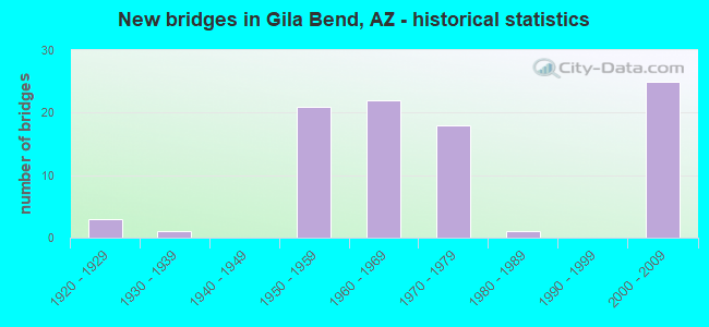
- New bridges - historical statistics
- 31920-1929
- 11930-1939
- 211950-1959
- 221960-1969
- 181970-1979
- 11980-1989
- 252000-2009
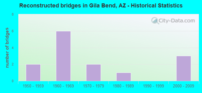
- Reconstructed bridges - Historical Statistics
- 21950-1959
- 61960-1969
- 21970-1979
- 11980-1989
- 01990-1999
- 32000-2009
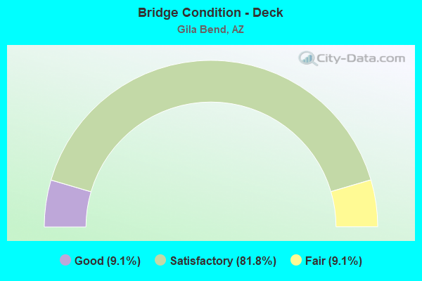
- Bridge Condition - Deck
- 9.1%Good
- 81.8%Satisfactory
- 9.1%Fair
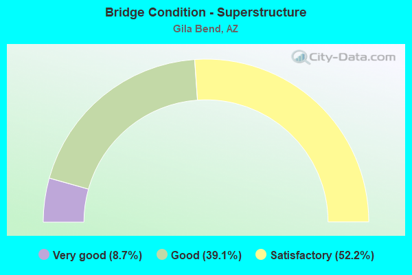
- Bridge Condition - Superstructure
- 8.7%Very good
- 39.1%Good
- 52.2%Satisfactory
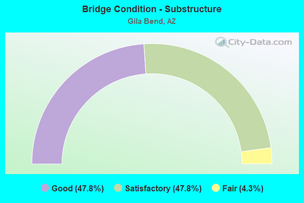
- Bridge Condition - Substructure
- 47.8%Good
- 47.8%Satisfactory
- 4.3%Fair
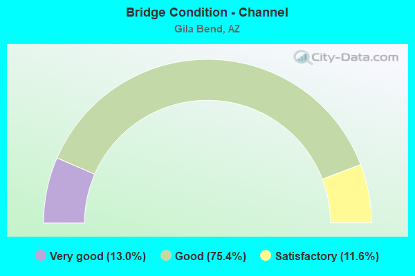
- Bridge Condition - Channel
- 13.0%Very good
- 75.4%Good
- 11.6%Satisfactory
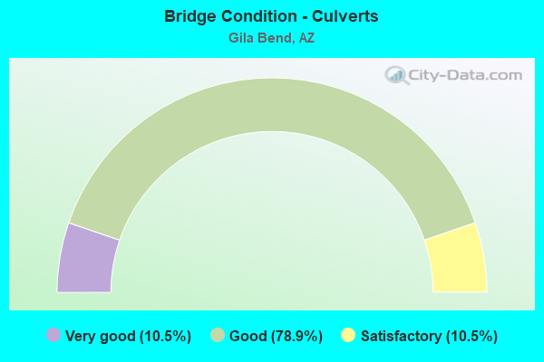
- Bridge Condition - Culverts
- 10.5%Very good
- 78.9%Good
- 10.5%Satisfactory
Find on map >> Show street view
Structure Number: 6492, Location: 1.9 mi SE Jct SR 85 (Lat: 32.934972, Lng: -112.679028), Route carried "on" structure: Business State highway 8, Year Built: 1959, Status: Open, Structure Length: 0.98m (3.22ft), Average Daily Traffic: 4,406 (year 2018), Truck Traffic: 56%, Average Future Daily Traffic: 4,416 (year 2038), Design Load: HS 20, Features Intersected: Wash
Minimum Vertical Clearance: 30+ m (98+ ft), Kilometerpoint: 196.630, Lanes on structure: 2, Owner: State Highway Agency, Approaching Roadway Width: 10.7m (35.1ft), Material/Design: Concrete continuous, Design/Construction: Culvert, Number Of Spans In Main Unit: 3, Length of Maximum Span: 3.0m (9.8ft), Curb or Sidewalk Widths: Left: 0.4m (1.3ft), Right: 0.4m (1.3ft), Curb-To-Curb Width: 10.5m (34.4ft), Out-to-Out Width: 12.7m (41.7ft)
Condition: Channel: Good, Culverts: Good, Operating Rating: 54.4 metric tons, Method Used To Determine Operating Rating: Load Factor (LF), Inventory Rating: 32.7 metric tons, Method Used To Determine Inventory Rating: Load Factor (LF), Structural Evaluation: Better than present minimum criteria, Deck Geometry: Somewhat better than minimum adequacy, Waterway Adequacy: Equal to present desirable criteria, Approach Roadway Alignment: Equal to present desirable criteria, Designated Inspection Frequency: Every 48 months, Inspection Date: April 2019, Deck Structure Type: Concrete Cast-file-Place, Wearing Surface/Protective System: Wearing Surface: Bituminous
Find on map >> Show street view
Structure Number: 6493, Location: 1.3 mi E Jct SR 85 (Lat: 32.934597, Lng: -112.713800), Route carried "on" structure: Interstate 8, Year Built: 1970, Status: Open, Structure Length: 0.88m (2.89ft), Average Daily Traffic: 6,654 (year 2018), Truck Traffic: 27%, Average Future Daily Traffic: 6,664 (year 2038), Design Load: HS 20, Features Intersected: Wash
Minimum Vertical Clearance: 30+ m (98+ ft), Kilometerpoint: 188.084, Lanes on structure: 4, Owner: State Highway Agency, Approaching Roadway Width: 23.2m (76.1ft), Skew: 24 degrees, Material/Design: Concrete continuous, Design/Construction: Culvert, Number Of Spans In Main Unit: 2, Length of Maximum Span: 3.0m (9.8ft)
Condition: Channel: Good, Culverts: Good, Operating Rating: 89.8 metric tons, Method Used To Determine Operating Rating: Load Factor (LF), Inventory Rating: 89.8 metric tons, Method Used To Determine Inventory Rating: Load Factor (LF), Structural Evaluation: Better than present minimum criteria, Waterway Adequacy: Equal to present desirable criteria, Approach Roadway Alignment: Equal to present desirable criteria, Designated Inspection Frequency: Every 48 months, Inspection Date: March 2019
Find on map >> Show street view
Structure Number: 6494, Location: 1.8 mi E Jct SR 85 (Lat: 32.933081, Lng: -112.706883), Route carried "on" structure: Interstate 8, Year Built: 1970, Status: Open, Structure Length: 1.65m (5.41ft), Average Daily Traffic: 6,654 (year 2013), Truck Traffic: 27%, Average Future Daily Traffic: 6,664 (year 2035), Design Load: HS 20, Features Intersected: Wash
Minimum Vertical Clearance: 30+ m (98+ ft), Kilometerpoint: 188.760, Lanes on structure: 4, Owner: State Highway Agency, Approaching Roadway Width: 23.2m (76.1ft), Skew: 20 degrees, Material/Design: Concrete continuous, Design/Construction: Culvert, Number Of Spans In Main Unit: 5, Length of Maximum Span: 3.0m (9.8ft)
Condition: Channel: Good, Culverts: Good, Operating Rating: 59.9 metric tons, Method Used To Determine Operating Rating: Load Factor (LF), Inventory Rating: 36.3 metric tons, Method Used To Determine Inventory Rating: Load Factor (LF), Structural Evaluation: Better than present minimum criteria, Waterway Adequacy: Equal to present minimum criteria, Approach Roadway Alignment: Equal to present desirable criteria, Designated Inspection Frequency: Every 48 months, Inspection Date: March 2019
Find on map >> Show street view
Structure Number: 6495, Location: 1.9 mi E Jct SR 85 (Lat: 32.932314, Lng: -112.703375), Route carried "on" structure: Interstate 8, Year Built: 1970, Status: Open, Structure Length: 0.98m (3.22ft), Average Daily Traffic: 6,654 (year 2013), Truck Traffic: 27%, Average Future Daily Traffic: 6,664 (year 2035), Design Load: HS 20, Features Intersected: Wash
Minimum Vertical Clearance: 30+ m (98+ ft), Kilometerpoint: 189.098, Lanes on structure: 4, Owner: State Highway Agency, Approaching Roadway Width: 23.2m (76.1ft), Skew: 20 degrees, Material/Design: Concrete continuous, Design/Construction: Culvert, Number Of Spans In Main Unit: 3, Length of Maximum Span: 3.0m (9.8ft)
Condition: Channel: Good, Culverts: Good, Operating Rating: 52.6 metric tons, Method Used To Determine Operating Rating: Load Factor (LF), Inventory Rating: 31.8 metric tons, Method Used To Determine Inventory Rating: Load Factor (LF), Structural Evaluation: Better than present minimum criteria, Waterway Adequacy: Equal to present desirable criteria, Approach Roadway Alignment: Equal to present desirable criteria, Designated Inspection Frequency: Every 48 months, Inspection Date: March 2019, Deck Structure Type: Concrete Cast-file-Place, Wearing Surface/Protective System: Wearing Surface: Bituminous
Find on map >> Show street view
Structure Number: 6496, Location: 2.2 mi E Jct SR 85 (Lat: 32.931189, Lng: -112.698261), Route carried "on" structure: Interstate 8, Year Built: 1970, Year Reconstructed: 1973, Status: Open, Structure Length: 1.89m (6.20ft), Average Daily Traffic: 6,664 (year 2018), Truck Traffic: 27%, Average Future Daily Traffic: 6,674 (year 2038), Design Load: HS 20, Features Intersected: Wash
Minimum Vertical Clearance: 30+ m (98+ ft), Kilometerpoint: 189.581, Lanes on structure: 4, Owner: State Highway Agency, Approaching Roadway Width: 23.2m (76.1ft), Skew: 23 degrees, Material/Design: Concrete continuous, Design/Construction: Culvert, Number Of Spans In Main Unit: 5, Length of Maximum Span: 3.0m (9.8ft)
Condition: Channel: Good, Culverts: Good, Operating Rating: 89.8 metric tons, Method Used To Determine Operating Rating: Load Factor (LF), Inventory Rating: 75.3 metric tons, Method Used To Determine Inventory Rating: Load Factor (LF), Structural Evaluation: Better than present minimum criteria, Waterway Adequacy: Equal to present desirable criteria, Approach Roadway Alignment: Equal to present desirable criteria, Designated Inspection Frequency: Every 48 months, Inspection Date: March 2019
Find on map >> Show street view
Structure Number: 6497, Location: 2.2 mi E Jct SR 85 (Lat: 32.931078, Lng: -112.697703), Route carried "on" structure: Interstate 8, Year Built: 1970, Year Reconstructed: 1973, Status: Open, Structure Length: 1.80m (5.91ft), Average Daily Traffic: 6,664 (year 2018), Truck Traffic: 27%, Average Future Daily Traffic: 6,674 (year 2038), Design Load: HS 20, Features Intersected: Wash
Minimum Vertical Clearance: 30+ m (98+ ft), Kilometerpoint: 189.645, Lanes on structure: 4, Owner: State Highway Agency, Approaching Roadway Width: 23.2m (76.1ft), Skew: 23 degrees, Material/Design: Concrete continuous, Design/Construction: Culvert, Number Of Spans In Main Unit: 4, Length of Maximum Span: 3.7m (12.1ft)
Condition: Channel: Good, Culverts: Good, Operating Rating: 89.8 metric tons, Method Used To Determine Operating Rating: Load Factor (LF), Inventory Rating: 75.3 metric tons, Method Used To Determine Inventory Rating: Load Factor (LF), Structural Evaluation: Better than present minimum criteria, Waterway Adequacy: Equal to present desirable criteria, Approach Roadway Alignment: Equal to present desirable criteria, Designated Inspection Frequency: Every 48 months, Inspection Date: March 2019
Find on map >> Show street view
Structure Number: 6498, Location: 2.3 mi E Jct SR 85 (Lat: 32.930636, Lng: -112.695669), Route carried "on" structure: Interstate 8, Year Built: 1970, Status: Open, Structure Length: 2.77m (9.09ft), Average Daily Traffic: 6,664 (year 2018), Truck Traffic: 27%, Average Future Daily Traffic: 6,674 (year 2038), Design Load: HS 20, Features Intersected: Wash
Minimum Vertical Clearance: 30+ m (98+ ft), Kilometerpoint: 189.822, Lanes on structure: 4, Owner: State Highway Agency, Approaching Roadway Width: 23.2m (76.1ft), Skew: 24 degrees, Material/Design: Concrete continuous, Design/Construction: Culvert, Number Of Spans In Main Unit: 6, Length of Maximum Span: 3.0m (9.8ft)
Condition: Channel: Good, Culverts: Good, Operating Rating: 62.6 metric tons, Method Used To Determine Operating Rating: Load Factor (LF), Inventory Rating: 37.2 metric tons, Method Used To Determine Inventory Rating: Load Factor (LF), Structural Evaluation: Better than present minimum criteria, Waterway Adequacy: Equal to present desirable criteria, Approach Roadway Alignment: Equal to present desirable criteria, Designated Inspection Frequency: Every 48 months, Inspection Date: March 2019
Find on map >> Show street view
Structure Number: 6499, Location: 2.5 mi E Jct SR 85 (Lat: 32.930119, Lng: -112.693375), Route carried "on" structure: Interstate 8, Year Built: 1970, Year Reconstructed: 1973, Status: Open, Structure Length: 1.13m (3.71ft), Average Daily Traffic: 6,664 (year 2018), Truck Traffic: 27%, Average Future Daily Traffic: 6,674 (year 2038), Design Load: HS 20, Features Intersected: Wash
Minimum Vertical Clearance: 30+ m (98+ ft), Kilometerpoint: 190.064, Lanes on structure: 4, Owner: State Highway Agency, Approaching Roadway Width: 23.2m (76.1ft), Skew: 23 degrees, Material/Design: Concrete continuous, Design/Construction: Culvert, Number Of Spans In Main Unit: 3, Length of Maximum Span: 3.0m (9.8ft)
Condition: Channel: Good, Culverts: Good, Operating Rating: 63.5 metric tons, Method Used To Determine Operating Rating: Load Factor (LF), Inventory Rating: 38.1 metric tons, Method Used To Determine Inventory Rating: Load Factor (LF), Structural Evaluation: Better than present minimum criteria, Waterway Adequacy: Equal to present desirable criteria, Approach Roadway Alignment: Equal to present desirable criteria, Designated Inspection Frequency: Every 48 months, Inspection Date: March 2019
Find on map >> Show street view
Structure Number: 65, Location: 2.7 mi E Jct SR 85 (Lat: 32.929828, Lng: -112.691989), Route carried "on" structure: Interstate 8, Year Built: 1970, Year Reconstructed: 1973, Status: Open, Structure Length: 1.13m (3.71ft), Average Daily Traffic: 6,664 (year 2018), Truck Traffic: 27%, Average Future Daily Traffic: 6,674 (year 2038), Design Load: HS 20, Features Intersected: Wash
Minimum Vertical Clearance: 30+ m (98+ ft), Kilometerpoint: 190.192, Lanes on structure: 4, Owner: State Highway Agency, Approaching Roadway Width: 23.2m (76.1ft), Skew: 23 degrees, Material/Design: Concrete continuous, Design/Construction: Culvert, Number Of Spans In Main Unit: 3, Length of Maximum Span: 3.0m (9.8ft)
Condition: Channel: Good, Culverts: Good, Operating Rating: 63.5 metric tons, Method Used To Determine Operating Rating: Load Factor (LF), Inventory Rating: 38.1 metric tons, Method Used To Determine Inventory Rating: Load Factor (LF), Structural Evaluation: Better than present minimum criteria, Waterway Adequacy: Equal to present desirable criteria, Approach Roadway Alignment: Equal to present desirable criteria, Designated Inspection Frequency: Every 48 months, Inspection Date: March 2019
Find on map >> Show street view
Structure Number: 7121, Location: 28.3 mi S JCT I-10 (Lat: 33.021167, Lng: -112.650111), Route carried "on" structure: State highway 85, Year Built: 2006, Status: Open, Structure Length: 0.98m (3.22ft), Average Daily Traffic: 5,500 (year 2018), Truck Traffic: 34%, Average Future Daily Traffic: 5,510 (year 2038), Design Load: HS 20, Features Intersected: Wash
Minimum Vertical Clearance: 30+ m (98+ ft), Kilometerpoint: 203.131, Lanes on structure: 2, Owner: State Highway Agency, Approaching Roadway Width: 13.1m (43.0ft), Material/Design: Concrete continuous, Design/Construction: Culvert, Number Of Spans In Main Unit: 3, Length of Maximum Span: 3.0m (9.8ft)
Condition: Channel: Good, Culverts: Good, Operating Rating: 63.5 metric tons, Method Used To Determine Operating Rating: Load Factor (LF), Inventory Rating: 38.1 metric tons, Method Used To Determine Inventory Rating: Load Factor (LF), Structural Evaluation: Better than present minimum criteria, Waterway Adequacy: Equal to present desirable criteria, Approach Roadway Alignment: Equal to present desirable criteria, Designated Inspection Frequency: Every 48 months, Inspection Date: April 2019
Find on map >> Show street view
Structure Number: 7122, Location: 28.0 mi S JCT I-10 (Lat: 33.026250, Lng: -112.648861), Route carried "on" structure: State highway 85, Year Built: 2006, Status: Open, Structure Length: 0.64m (2.10ft), Average Daily Traffic: 5,500 (year 2018), Truck Traffic: 34%, Average Future Daily Traffic: 5,510 (year 2038), Design Load: HS 20, Features Intersected: Wash
Minimum Vertical Clearance: 30+ m (98+ ft), Kilometerpoint: 203.711, Lanes on structure: 2, Owner: State Highway Agency, Approaching Roadway Width: 13.1m (43.0ft), Material/Design: Concrete continuous, Design/Construction: Culvert, Number Of Spans In Main Unit: 2, Length of Maximum Span: 3.0m (9.8ft)
Condition: Channel: Good, Culverts: Good, Operating Rating: 89.8 metric tons, Method Used To Determine Operating Rating: Load Factor (LF), Inventory Rating: 75.3 metric tons, Method Used To Determine Inventory Rating: Load Factor (LF), Structural Evaluation: Better than present minimum criteria, Waterway Adequacy: Equal to present desirable criteria, Approach Roadway Alignment: Equal to present desirable criteria, Designated Inspection Frequency: Every 48 months, Inspection Date: April 2019
Find on map >> Show street view
Structure Number: 7123, Location: 27.8 mi S JCT I-10 (Lat: 33.028611, Lng: -112.648278), Route carried "on" structure: State highway 85, Year Built: 2006, Status: Open, Structure Length: 0.67m (2.20ft), Average Daily Traffic: 5,500 (year 2018), Truck Traffic: 34%, Average Future Daily Traffic: 5,510 (year 2038), Design Load: HS 20, Features Intersected: Wash
Minimum Vertical Clearance: 30+ m (98+ ft), Kilometerpoint: 203.968, Lanes on structure: 2, Owner: State Highway Agency, Approaching Roadway Width: 13.1m (43.0ft), Skew: 2 degrees, Material/Design: Concrete continuous, Design/Construction: Culvert, Number Of Spans In Main Unit: 2, Length of Maximum Span: 3.0m (9.8ft)
Condition: Channel: Good, Culverts: Good, Operating Rating: 64.4 metric tons, Method Used To Determine Operating Rating: Load Factor (LF), Inventory Rating: 38.1 metric tons, Method Used To Determine Inventory Rating: Load Factor (LF), Structural Evaluation: Better than present minimum criteria, Waterway Adequacy: Equal to present desirable criteria, Approach Roadway Alignment: Equal to present desirable criteria, Designated Inspection Frequency: Every 48 months, Inspection Date: April 2019
Find on map >> Show street view
Structure Number: 7125, Location: 27.7 mi S JCT I-10 (Lat: 33.029944, Lng: -112.647944), Route carried "on" structure: State highway 85, Year Built: 2006, Status: Open, Structure Length: 0.73m (2.40ft), Average Daily Traffic: 5,500 (year 2018), Truck Traffic: 34%, Average Future Daily Traffic: 5,510 (year 2038), Design Load: HS 20, Features Intersected: Wash
Minimum Vertical Clearance: 30+ m (98+ ft), Kilometerpoint: 204.129, Lanes on structure: 2, Owner: State Highway Agency, Approaching Roadway Width: 13.1m (43.0ft), Skew: 3 degrees, Material/Design: Concrete continuous, Design/Construction: Culvert, Number Of Spans In Main Unit: 2, Length of Maximum Span: 3.7m (12.1ft)
Condition: Channel: Good, Culverts: Good, Operating Rating: 89.8 metric tons, Method Used To Determine Operating Rating: Load Factor (LF), Inventory Rating: 74.4 metric tons, Method Used To Determine Inventory Rating: Load Factor (LF), Structural Evaluation: Better than present minimum criteria, Waterway Adequacy: Equal to present desirable criteria, Approach Roadway Alignment: Equal to present desirable criteria, Designated Inspection Frequency: Every 48 months, Inspection Date: April 2019
Find on map >> Show street view
Structure Number: 7126, Location: 27.4 mi S JCT I-10 (Lat: 33.034361, Lng: -112.646861), Route carried "on" structure: State highway 85, Year Built: 2006, Status: Open, Structure Length: 1.98m (6.50ft), Average Daily Traffic: 5,500 (year 2018), Truck Traffic: 34%, Average Future Daily Traffic: 5,510 (year 2038), Design Load: HS 20, Features Intersected: Wash
Minimum Vertical Clearance: 30+ m (98+ ft), Kilometerpoint: 204.628, Lanes on structure: 2, Owner: State Highway Agency, Approaching Roadway Width: 13.1m (43.0ft), Material/Design: Concrete continuous, Design/Construction: Culvert, Number Of Spans In Main Unit: 6, Length of Maximum Span: 3.0m (9.8ft)
Condition: Channel: Very good, Culverts: Very good, Operating Rating: 89.8 metric tons, Method Used To Determine Operating Rating: Load Factor (LF), Inventory Rating: 75.3 metric tons, Method Used To Determine Inventory Rating: Load Factor (LF), Structural Evaluation: Equal to present desirable criteria, Waterway Adequacy: Equal to present desirable criteria, Approach Roadway Alignment: Equal to present desirable criteria, Designated Inspection Frequency: Every 48 months, Inspection Date: April 2019
Find on map >> Show street view
Structure Number: 7127, Location: 27.0 mi S JCT I-10 (Lat: 33.040194, Lng: -112.645806), Route carried "on" structure: State highway 85, Year Built: 2006, Status: Open, Structure Length: 0.64m (2.10ft), Average Daily Traffic: 5,500 (year 2018), Truck Traffic: 34%, Average Future Daily Traffic: 5,510 (year 2038), Design Load: HS 20, Features Intersected: Wash
Minimum Vertical Clearance: 30+ m (98+ ft), Kilometerpoint: 205.288, Lanes on structure: 2, Owner: State Highway Agency, Approaching Roadway Width: 13.1m (43.0ft), Material/Design: Concrete continuous, Design/Construction: Culvert, Number Of Spans In Main Unit: 2, Length of Maximum Span: 3.0m (9.8ft)
Condition: Channel: Good, Culverts: Good, Operating Rating: 89.8 metric tons, Method Used To Determine Operating Rating: Load Factor (LF), Inventory Rating: 76.2 metric tons, Method Used To Determine Inventory Rating: Load Factor (LF), Structural Evaluation: Better than present minimum criteria, Waterway Adequacy: Equal to present desirable criteria, Approach Roadway Alignment: Equal to present desirable criteria, Designated Inspection Frequency: Every 48 months, Inspection Date: April 2019
Find on map >> Show street view
Structure Number: 7128, Location: 26.1 mi S JCT I-10 (Lat: 33.052833, Lng: -112.644111), Route carried "on" structure: State highway 85, Year Built: 2006, Status: Open, Structure Length: 0.98m (3.22ft), Average Daily Traffic: 5,500 (year 2018), Truck Traffic: 34%, Average Future Daily Traffic: 5,510 (year 2038), Design Load: HS 20, Features Intersected: Wash
Minimum Vertical Clearance: 30+ m (98+ ft), Kilometerpoint: 206.704, Lanes on structure: 2, Owner: State Highway Agency, Approaching Roadway Width: 13.1m (43.0ft), Material/Design: Concrete continuous, Design/Construction: Culvert, Number Of Spans In Main Unit: 3, Length of Maximum Span: 3.0m (9.8ft)
Condition: Channel: Good, Culverts: Good, Operating Rating: 89.8 metric tons, Method Used To Determine Operating Rating: Load Factor (LF), Inventory Rating: 75.3 metric tons, Method Used To Determine Inventory Rating: Load Factor (LF), Structural Evaluation: Better than present minimum criteria, Waterway Adequacy: Equal to present desirable criteria, Approach Roadway Alignment: Equal to present desirable criteria, Designated Inspection Frequency: Every 48 months, Inspection Date: April 2019
Find on map >> Show street view
Structure Number: 7129, Location: 25.7 mi S JCT I-10 (Lat: 33.059361, Lng: -112.644833), Route carried "on" structure: State highway 85, Year Built: 2006, Status: Open, Structure Length: 0.64m (2.10ft), Average Daily Traffic: 5,500 (year 2018), Truck Traffic: 34%, Average Future Daily Traffic: 5,510 (year 2038), Design Load: HS 20, Features Intersected: Wash
Minimum Vertical Clearance: 30+ m (98+ ft), Kilometerpoint: 207.428, Lanes on structure: 2, Owner: State Highway Agency, Approaching Roadway Width: 13.1m (43.0ft), Material/Design: Concrete continuous, Design/Construction: Culvert, Number Of Spans In Main Unit: 2, Length of Maximum Span: 3.0m (9.8ft)
Condition: Channel: Very good, Culverts: Good, Operating Rating: 60.8 metric tons, Method Used To Determine Operating Rating: Load Factor (LF), Inventory Rating: 36.3 metric tons, Method Used To Determine Inventory Rating: Load Factor (LF), Structural Evaluation: Better than present minimum criteria, Waterway Adequacy: Equal to present desirable criteria, Approach Roadway Alignment: Equal to present desirable criteria, Designated Inspection Frequency: Every 48 months, Inspection Date: April 2019
Find on map >> Show street view
Structure Number: 713, Location: 25.6 mi S JCT I-10 (Lat: 33.060139, Lng: -112.644917), Route carried "on" structure: State highway 85, Year Built: 2006, Status: Open, Structure Length: 0.64m (2.10ft), Average Daily Traffic: 5,500 (year 2018), Truck Traffic: 34%, Average Future Daily Traffic: 5,510 (year 2038), Design Load: HS 20, Features Intersected: Wash
Minimum Vertical Clearance: 30+ m (98+ ft), Kilometerpoint: 207.509, Lanes on structure: 2, Owner: State Highway Agency, Approaching Roadway Width: 13.1m (43.0ft), Skew: 1 degrees, Material/Design: Concrete continuous, Design/Construction: Culvert, Number Of Spans In Main Unit: 2, Length of Maximum Span: 3.0m (9.8ft)
Condition: Channel: Very good, Culverts: Good, Operating Rating: 89.8 metric tons, Method Used To Determine Operating Rating: Load Factor (LF), Inventory Rating: 89.8 metric tons, Method Used To Determine Inventory Rating: Load Factor (LF), Structural Evaluation: Better than present minimum criteria, Waterway Adequacy: Equal to present desirable criteria, Approach Roadway Alignment: Equal to present desirable criteria, Designated Inspection Frequency: Every 48 months, Inspection Date: April 2019
Find on map >> Show street view
Structure Number: 7131, Location: 24.7 mi S JCT I-10 (Lat: 33.073639, Lng: -112.646528), Route carried "on" structure: State highway 85, Year Built: 2006, Status: Open, Structure Length: 1.31m (4.30ft), Average Daily Traffic: 5,500 (year 2018), Truck Traffic: 34%, Average Future Daily Traffic: 5,510 (year 2038), Design Load: HS 20, Features Intersected: Wash
Minimum Vertical Clearance: 30+ m (98+ ft), Kilometerpoint: 209.022, Lanes on structure: 2, Owner: State Highway Agency, Approaching Roadway Width: 13.1m (43.0ft), Material/Design: Concrete continuous, Design/Construction: Culvert, Number Of Spans In Main Unit: 4, Length of Maximum Span: 3.0m (9.8ft)
Condition: Channel: Satisfactory, Culverts: Good, Operating Rating: 89.8 metric tons, Method Used To Determine Operating Rating: Load Factor (LF), Inventory Rating: 74.4 metric tons, Method Used To Determine Inventory Rating: Load Factor (LF), Structural Evaluation: Better than present minimum criteria, Waterway Adequacy: Equal to present desirable criteria, Approach Roadway Alignment: Equal to present desirable criteria, Designated Inspection Frequency: Every 48 months, Inspection Date: April 2019
Find on map >> Show street view
Structure Number: 7132, Location: 24.6 mi S JCT I-10 (Lat: 33.075100, Lng: -112.646700), Route carried "on" structure: State highway 85, Year Built: 2006, Status: Open, Structure Length: 0.98m (3.22ft), Average Daily Traffic: 5,500 (year 2018), Truck Traffic: 34%, Average Future Daily Traffic: 5,510 (year 2038), Design Load: HS 20, Features Intersected: Wash
Minimum Vertical Clearance: 30+ m (98+ ft), Kilometerpoint: 209.231, Lanes on structure: 2, Owner: State Highway Agency, Approaching Roadway Width: 13.1m (43.0ft), Material/Design: Concrete continuous, Design/Construction: Culvert, Number Of Spans In Main Unit: 3, Length of Maximum Span: 3.0m (9.8ft)
Condition: Channel: Very good, Culverts: Good, Operating Rating: 89.8 metric tons, Method Used To Determine Operating Rating: Load Factor (LF), Inventory Rating: 70.8 metric tons, Method Used To Determine Inventory Rating: Load Factor (LF), Structural Evaluation: Better than present minimum criteria, Waterway Adequacy: Equal to present desirable criteria, Approach Roadway Alignment: Equal to present desirable criteria, Designated Inspection Frequency: Every 48 months, Inspection Date: April 2019
Find on map >> Show street view
Structure Number: 7154, Location: 30.7 mi S JCT I-10 (Lat: 32.989139, Lng: -112.664667), Route carried "on" structure: State highway 85, Year Built: 2006, Status: Open, Structure Length: 2.65m (8.69ft), Average Daily Traffic: 5,500 (year 2017), Truck Traffic: 34%, Average Future Daily Traffic: 5,510 (year 2037), Design Load: HS 20, Features Intersected: Cross Drainage
Minimum Vertical Clearance: 30+ m (98+ ft), Kilometerpoint: 199.333, Lanes on structure: 2, Owner: State Highway Agency, Approaching Roadway Width: 13.1m (43.0ft), Skew: 1 degrees, Material/Design: Concrete continuous, Design/Construction: Culvert, Number Of Spans In Main Unit: 8, Length of Maximum Span: 3.0m (9.8ft)
Condition: Channel: Good, Culverts: Very good, Operating Rating: 50.8 metric tons, Method Used To Determine Operating Rating: Load Factor (LF), Inventory Rating: 29.9 metric tons, Method Used To Determine Inventory Rating: Load Factor (LF), Structural Evaluation: Better than present minimum criteria, Waterway Adequacy: Equal to present desirable criteria, Approach Roadway Alignment: Equal to present desirable criteria, Designated Inspection Frequency: Every 48 months, Inspection Date: April 2019
Find on map >> Show street view
Structure Number: 7155, Location: 30.6 mi S JCT I-10 (Lat: 32.990000, Lng: -112.664300), Route carried "on" structure: State highway 85, Year Built: 2006, Status: Open, Structure Length: 2.65m (8.69ft), Average Daily Traffic: 5,500 (year 2018), Truck Traffic: 34%, Average Future Daily Traffic: 5,510 (year 2038), Design Load: HS 20, Features Intersected: Cross Drainage
Minimum Vertical Clearance: 30+ m (98+ ft), Kilometerpoint: 199.446, Lanes on structure: 2, Owner: State Highway Agency, Approaching Roadway Width: 13.1m (43.0ft), Material/Design: Concrete continuous, Design/Construction: Culvert, Number Of Spans In Main Unit: 8, Length of Maximum Span: 3.0m (9.8ft)
Condition: Channel: Very good, Culverts: Good, Operating Rating: 89.8 metric tons, Method Used To Determine Operating Rating: Load Factor (LF), Inventory Rating: 74.4 metric tons, Method Used To Determine Inventory Rating: Load Factor (LF), Structural Evaluation: Better than present minimum criteria, Waterway Adequacy: Equal to present desirable criteria, Approach Roadway Alignment: Equal to present desirable criteria, Designated Inspection Frequency: Every 48 months, Inspection Date: April 2019
Find on map >> Show street view
Structure Number: 7156, Location: 30.25 mi S JCT I-10 (Lat: 32.994972, Lng: -112.661917), Route carried "on" structure: State highway 85, Year Built: 2006, Status: Open, Structure Length: 0.70m (2.30ft), Average Daily Traffic: 5,500 (year 2018), Truck Traffic: 34%, Average Future Daily Traffic: 5,510 (year 2038), Design Load: HS 20, Features Intersected: Cross Drainage
Minimum Vertical Clearance: 30+ m (98+ ft), Kilometerpoint: 200.025, Lanes on structure: 2, Owner: State Highway Agency, Approaching Roadway Width: 13.1m (43.0ft), Skew: 2 degrees, Material/Design: Concrete continuous, Design/Construction: Culvert, Number Of Spans In Main Unit: 2, Length of Maximum Span: 3.4m (11.2ft)
Condition: Channel: Good, Culverts: Good, Operating Rating: 89.8 metric tons, Method Used To Determine Operating Rating: Load Factor (LF), Inventory Rating: 74.4 metric tons, Method Used To Determine Inventory Rating: Load Factor (LF), Structural Evaluation: Better than present minimum criteria, Waterway Adequacy: Equal to present desirable criteria, Approach Roadway Alignment: Equal to present desirable criteria, Designated Inspection Frequency: Every 48 months, Inspection Date: April 2019
Find on map >> Show street view
Structure Number: 7157, Location: 29.4 mi S JCT I-10 (Lat: 33.006500, Lng: -112.656500), Route carried "on" structure: State highway 85, Year Built: 2006, Status: Open, Structure Length: 1.98m (6.50ft), Average Daily Traffic: 5,500 (year 2018), Truck Traffic: 34%, Average Future Daily Traffic: 5,510 (year 2038), Design Load: HS 20, Features Intersected: Cross Drainage
Minimum Vertical Clearance: 30+ m (98+ ft), Kilometerpoint: 201.425, Lanes on structure: 2, Owner: State Highway Agency, Approaching Roadway Width: 13.1m (43.0ft), Material/Design: Concrete continuous, Design/Construction: Culvert, Number Of Spans In Main Unit: 6, Length of Maximum Span: 3.0m (9.8ft)
Condition: Channel: Good, Culverts: Good, Operating Rating: 62.6 metric tons, Method Used To Determine Operating Rating: Load Factor (LF), Inventory Rating: 37.2 metric tons, Method Used To Determine Inventory Rating: Load Factor (LF), Structural Evaluation: Better than present minimum criteria, Waterway Adequacy: Equal to present desirable criteria, Approach Roadway Alignment: Equal to present desirable criteria, Designated Inspection Frequency: Every 48 months, Inspection Date: April 2019
Find on map >> Show street view
Structure Number: 7158, Location: 29.0 mi S JCT I-10 (Lat: 33.011400, Lng: -112.654100), Route carried "on" structure: State highway 85, Year Built: 2006, Status: Open, Structure Length: 2.65m (8.69ft), Average Daily Traffic: 5,500 (year 2018), Truck Traffic: 34%, Average Future Daily Traffic: 5,510 (year 2038), Design Load: HS 20, Features Intersected: Cross Drainage
Minimum Vertical Clearance: 30+ m (98+ ft), Kilometerpoint: 202.005, Lanes on structure: 2, Owner: State Highway Agency, Approaching Roadway Width: 13.1m (43.0ft), Material/Design: Concrete continuous, Design/Construction: Culvert, Number Of Spans In Main Unit: 8, Length of Maximum Span: 3.0m (9.8ft)
Condition: Channel: Good, Culverts: Good, Operating Rating: 50.8 metric tons, Method Used To Determine Operating Rating: Load Factor (LF), Inventory Rating: 29.9 metric tons, Method Used To Determine Inventory Rating: Load Factor (LF), Structural Evaluation: Better than present minimum criteria, Waterway Adequacy: Equal to present desirable criteria, Approach Roadway Alignment: Equal to present desirable criteria, Designated Inspection Frequency: Every 48 months, Inspection Date: April 2019
Find on map >> Show street view
Structure Number: 7159, Location: 28.9 mi S JCT I-10 (Lat: 33.013417, Lng: -112.653222), Route carried "on" structure: State highway 85, Year Built: 2006, Status: Open, Structure Length: 1.98m (6.50ft), Average Daily Traffic: 5,500 (year 2018), Truck Traffic: 34%, Average Future Daily Traffic: 5,510 (year 2038), Design Load: HS 20, Features Intersected: Cross Drainage
Minimum Vertical Clearance: 30+ m (98+ ft), Kilometerpoint: 202.230, Lanes on structure: 2, Owner: State Highway Agency, Approaching Roadway Width: 13.1m (43.0ft), Material/Design: Concrete continuous, Design/Construction: Culvert, Number Of Spans In Main Unit: 6, Length of Maximum Span: 3.0m (9.8ft)
Condition: Channel: Good, Culverts: Very good, Operating Rating: 62.6 metric tons, Method Used To Determine Operating Rating: Load Factor (LF), Inventory Rating: 37.2 metric tons, Method Used To Determine Inventory Rating: Load Factor (LF), Structural Evaluation: Equal to present desirable criteria, Waterway Adequacy: Equal to present desirable criteria, Approach Roadway Alignment: Equal to present desirable criteria, Designated Inspection Frequency: Every 48 months, Inspection Date: April 2019
Find on map >> Show street view
Structure Number: 716, Location: 28.6 mi S JCT I-10 (Lat: 33.017306, Lng: -112.651417), Route carried "on" structure: State highway 85, Year Built: 2006, Status: Open, Structure Length: 2.04m (6.69ft), Average Daily Traffic: 5,500 (year 2018), Truck Traffic: 34%, Average Future Daily Traffic: 5,510 (year 2018), Design Load: HS 20, Features Intersected: Cross Drainage
Minimum Vertical Clearance: 30+ m (98+ ft), Kilometerpoint: 202.697, Lanes on structure: 2, Owner: State Highway Agency, Approaching Roadway Width: 13.1m (43.0ft), Skew: 1 degrees, Material/Design: Concrete continuous, Design/Construction: Culvert, Number Of Spans In Main Unit: 6, Length of Maximum Span: 3.0m (9.8ft)
Condition: Channel: Good, Culverts: Good, Operating Rating: 89.8 metric tons, Method Used To Determine Operating Rating: Load Factor (LF), Inventory Rating: 76.2 metric tons, Method Used To Determine Inventory Rating: Load Factor (LF), Structural Evaluation: Better than present minimum criteria, Waterway Adequacy: Equal to present desirable criteria, Approach Roadway Alignment: Equal to present desirable criteria, Designated Inspection Frequency: Every 48 months, Inspection Date: April 2019
Find on map >> Show street view
Structure Number: 7192, Location: 12.7 mi N Jct SR B 8 (Lat: 33.118700, Lng: -112.650100), Route carried "on" structure: State highway 85, Year Built: 2009, Status: Open, Structure Length: 0.64m (2.10ft), Average Daily Traffic: 11,074 (year 2018), Truck Traffic: 33%, Average Future Daily Traffic: 11,084 (year 2038), Design Load: HS 20, Features Intersected: Wash
Minimum Vertical Clearance: 30+ m (98+ ft), Kilometerpoint: 214.059, Lanes on structure: 2, Owner: State Highway Agency, Approaching Roadway Width: 11.6m (38.1ft), Material/Design: Concrete continuous, Design/Construction: Culvert, Number Of Spans In Main Unit: 2, Length of Maximum Span: 3.0m (9.8ft)
Condition: Channel: Very good, Culverts: Good, Operating Rating: 64.4 metric tons, Method Used To Determine Operating Rating: Load Factor (LF), Inventory Rating: 38.1 metric tons, Method Used To Determine Inventory Rating: Load Factor (LF), Structural Evaluation: Better than present minimum criteria, Waterway Adequacy: Equal to present desirable criteria, Approach Roadway Alignment: Equal to present desirable criteria, Designated Inspection Frequency: Every 48 months, Inspection Date: May 2019
Find on map >> Show street view
Structure Number: 7193, Location: 12.8 mi N Jct SR B 8 (Lat: 33.120444, Lng: -112.650083), Route carried "on" structure: State highway 85, Year Built: 2009, Status: Open, Structure Length: 1.10m (3.61ft), Average Daily Traffic: 11,074 (year 2018), Truck Traffic: 33%, Average Future Daily Traffic: 11,084 (year 2038), Design Load: HS 20, Features Intersected: Wash
Minimum Vertical Clearance: 30+ m (98+ ft), Kilometerpoint: 214.204, Lanes on structure: 4, Owner: State Highway Agency, Approaching Roadway Width: 23.8m (78.1ft), Skew: 22 degrees, Material/Design: Concrete continuous, Design/Construction: Culvert, Number Of Spans In Main Unit: 3, Length of Maximum Span: 3.4m (11.2ft)
Condition: Channel: Good, Culverts: Very good, Operating Rating: 63.5 metric tons, Method Used To Determine Operating Rating: Load Factor (LF), Inventory Rating: 38.1 metric tons, Method Used To Determine Inventory Rating: Load Factor (LF), Structural Evaluation: Equal to present desirable criteria, Waterway Adequacy: Equal to present desirable criteria, Approach Roadway Alignment: Equal to present desirable criteria, Designated Inspection Frequency: Every 48 months, Inspection Date: May 2019
Find on map >> Show street view
Structure Number: 7201, Location: 12.7 mi N Jct SR B 8 (Lat: 33.118722, Lng: -112.650750), Route carried "on" structure: ServiceState highway 85, Year Built: 2009, Status: Open, Structure Length: 0.64m (2.10ft), Average Daily Traffic: 100 (year 2018), Truck Traffic: 2%, Average Future Daily Traffic: 110 (year 2038), Design Load: HS 20, Features Intersected: Wash
Minimum Vertical Clearance: 30+ m (98+ ft), Kilometerpoint: 214.059, Lanes on structure: 2, Owner: State Highway Agency, Approaching Roadway Width: 9.8m (32.2ft), Material/Design: Concrete continuous, Design/Construction: Culvert, Number Of Spans In Main Unit: 2, Length of Maximum Span: 3.0m (9.8ft)
Condition: Channel: Good, Culverts: Very good, Operating Rating: 64.4 metric tons, Method Used To Determine Operating Rating: Load Factor (LF), Inventory Rating: 38.1 metric tons, Method Used To Determine Inventory Rating: Load Factor (LF), Structural Evaluation: Equal to present desirable criteria, Waterway Adequacy: Equal to present desirable criteria, Approach Roadway Alignment: Equal to present desirable criteria, Designated Inspection Frequency: Every 48 months, Inspection Date: May 2019
Find on map >> Show street view
Structure Number: 7202, Location: 12.8 mi N Jct SR B 8 (Lat: 33.120083, Lng: -112.650833), Route carried "on" structure: ServiceState highway 85, Year Built: 2009, Status: Open, Structure Length: 1.04m (3.41ft), Average Daily Traffic: 100 (year 2019), Truck Traffic: 2%, Average Future Daily Traffic: 110 (year 2039), Design Load: HS 20, Features Intersected: Wash
Minimum Vertical Clearance: 30+ m (98+ ft), Kilometerpoint: 214.172, Lanes on structure: 2, Owner: State Highway Agency, Approaching Roadway Width: 9.8m (32.2ft), Skew: 1 degrees, Material/Design: Concrete continuous, Design/Construction: Culvert, Number Of Spans In Main Unit: 3, Length of Maximum Span: 3.0m (9.8ft)
Condition: Channel: Good, Culverts: Very good, Operating Rating: 63.5 metric tons, Method Used To Determine Operating Rating: Load Factor (LF), Inventory Rating: 38.1 metric tons, Method Used To Determine Inventory Rating: Load Factor (LF), Structural Evaluation: Equal to present desirable criteria, Waterway Adequacy: Equal to present desirable criteria, Approach Roadway Alignment: Equal to present desirable criteria, Designated Inspection Frequency: Every 48 months, Inspection Date: May 2019
Find on map >> Show street view
Structure Number: 7243, Location: 10.9 mi N Jct B 8 (Lat: 33.093111, Lng: -112.648889), Route carried "on" structure: State highway 85, Year Built: 2009, Status: Open, Structure Length: 1.25m (4.10ft), Average Daily Traffic: 11,074 (year 2018), Truck Traffic: 33%, Average Future Daily Traffic: 11,084 (year 2038), Design Load: HS 20, Features Intersected: Wash
Minimum Vertical Clearance: 30+ m (98+ ft), Kilometerpoint: 211.114, Lanes on structure: 4, Owner: State Highway Agency, Approaching Roadway Width: 25.6m (84.0ft), Skew: 21 degrees, Material/Design: Concrete continuous, Design/Construction: Culvert, Number Of Spans In Main Unit: 4, Length of Maximum Span: 3.0m (9.8ft)
Condition: Channel: Good, Culverts: Good, Operating Rating: 59.9 metric tons, Method Used To Determine Operating Rating: Load Factor (LF), Inventory Rating: 35.4 metric tons, Method Used To Determine Inventory Rating: Load Factor (LF), Structural Evaluation: Better than present minimum criteria, Waterway Adequacy: Equal to present desirable criteria, Approach Roadway Alignment: Equal to present desirable criteria, Length Of Structure Improvement: 2.01m (6.59ft), Designated Inspection Frequency: Every 48 months, Inspection Date: April 2019, Bridge Improvement Cost: $1,000, Total Project Cost: $2,000
Find on map >> Show street view
Structure Number: 8695, Location: 0.2 mi So Jct SR 85 (Lat: 32.944600, Lng: -112.715700), Route carried "on" structure: City street , Year Built: 1983, Status: Open, Structure Length: 1.43m (4.69ft), Average Daily Traffic: 1,020 (year 2021), Truck Traffic: 2%, Average Future Daily Traffic: 1,030 (year 2041), Design Load: HS 20, Features Intersected: Gillespie Canal, Facility Carried by Structure: Martin Ave
Minimum Vertical Clearance: 7.62m (25.00ft), Kilometerpoint: 0.000, Lanes on structure: 2, Owner: Town or Township Highway Agency, Approaching Roadway Width: 7.0m (23.0ft), Material/Design: Prestressed concrete, Design/Construction: Box Beam or Girders - Multiple, Number Of Spans In Main Unit: 1, Length of Maximum Span: 14.0m (45.9ft), Curb-To-Curb Width: 14.6m (47.9ft), Out-to-Out Width: 15.8m (51.8ft)
Condition: Deck: Good, Superstructure: Good, Substructure: Good, Channel: Good, Operating Rating: 72.6 metric tons, Method Used To Determine Operating Rating: Load Factor (LF), Inventory Rating: 43.5 metric tons, Method Used To Determine Inventory Rating: Load Factor (LF), Structural Evaluation: Better than present minimum criteria, Deck Geometry: Superior to present desirable criteria, Waterway Adequacy: Equal to present desirable criteria, Approach Roadway Alignment: Equal to present desirable criteria, Designated Inspection Frequency: Every 24 months, Inspection Date: November 2021, Deck Structure Type: Concrete Precast Panels, Wearing Surface/Protective System: Wearing Surface: Bituminous
Find on map >> Show street view
Structure Number: 10675, Location: 0.5 mi W of B-8 (Lat: 32.942000, Lng: -112.697200), Route carried "on" structure: City street , Year Built: 2000, Status: Open, Structure Length: 0.85m (2.79ft), Average Daily Traffic: 200 (year 2021), Truck Traffic: 2%, Average Future Daily Traffic: 210 (year 2041), Design Load: HS 20, Features Intersected: Wash, Facility Carried by Structure: Main Street
Minimum Vertical Clearance: 30+ m (98+ ft), Kilometerpoint: 0.000, Lanes on structure: 2, Owner: Town or Township Highway Agency, Approaching Roadway Width: 14.6m (47.9ft), Skew: 3 degrees, Material/Design: Concrete continuous, Design/Construction: Culvert, Number Of Spans In Main Unit: 3, Length of Maximum Span: 1.8m (5.9ft)
Condition: Channel: Good, Culverts: Good, Operating Rating: 78.9 metric tons, Method Used To Determine Operating Rating: Load Factor (LF), Inventory Rating: 47.2 metric tons, Method Used To Determine Inventory Rating: Load Factor (LF), Structural Evaluation: Better than present minimum criteria, Waterway Adequacy: Equal to present desirable criteria, Approach Roadway Alignment: Equal to present desirable criteria, Designated Inspection Frequency: Every 48 months, Inspection Date: April 2021, Deck Structure Type: Concrete Cast-file-Place, Wearing Surface/Protective System: Wearing Surface: Bituminous
Find on map >> Show street view
Structure Number: 10676, Location: 0.4 mi W Jct I-8B (Lat: 32.942000, Lng: -112.695200), Route carried "on" structure: City street , Year Built: 2000, Status: Open, Structure Length: 0.67m (2.20ft), Average Daily Traffic: 200 (year 2021), Truck Traffic: 2%, Average Future Daily Traffic: 210 (year 2041), Design Load: HS 20, Features Intersected: Wash, Facility Carried by Structure: Main Street
Minimum Vertical Clearance: 0.00m, Kilometerpoint: 0.000, Lanes on structure: 2, Owner: Town or Township Highway Agency, Approaching Roadway Width: 14.6m (47.9ft), Skew: 1 degrees, Material/Design: Concrete continuous, Design/Construction: Culvert, Number Of Spans In Main Unit: 3, Length of Maximum Span: 1.8m (5.9ft)
Condition: Channel: Satisfactory, Culverts: Satisfactory, Operating Rating: 78.9 metric tons, Method Used To Determine Operating Rating: Load Factor (LF), Inventory Rating: 47.2 metric tons, Method Used To Determine Inventory Rating: Load Factor (LF), Structural Evaluation: Equal to present minimum criteria, Waterway Adequacy: Equal to present desirable criteria, Approach Roadway Alignment: Equal to present desirable criteria, Designated Inspection Frequency: Every 48 months, Inspection Date: April 2021
Find on map >> Show street view
Structure Number: 57, Location: 4.2 mi W Jct SR 85 (Lat: 32.932100, Lng: -112.804100), Route carried "under" structure: County highway , Year Built: 1960, Structure Length: 0. m, Average Daily Traffic: 200 (year 2013), Truck Traffic: 5%, Features Intersected: Citrus Valley Rd, Facility Carried by Structure: I-8 EB
Minimum Vertical Clearance: 4.49m (14.73ft), Kilometerpoint: 0.000, Lanes on structure: 2, Lanes under structure: 2, Material/Design: Concrete continuous, Design/Construction: Slab, Length of Maximum Span: 11.0m (36.1ft)
Find on map >> Show street view
Structure Number: 571, Location: 4.2 mi W Jct SR 85 (Lat: 32.932400, Lng: -112.804200), Route carried "under" structure: County highway , Year Built: 1960, Structure Length: 0. m, Average Daily Traffic: 200 (year 2019), Truck Traffic: 5%, Features Intersected: Citrus Valley Rd, Facility Carried by Structure: I-8 WB
Minimum Vertical Clearance: 4.47m (14.67ft), Kilometerpoint: 0.000, Lanes on structure: 2, Lanes under structure: 2, Material/Design: Concrete continuous, Design/Construction: Slab, Length of Maximum Span: 11.0m (36.1ft)
Find on map >> Show street view
Structure Number: 702, Location: 0.4 mi N Jct I-8 (Lat: 32.943300, Lng: -112.735100), Route carried "under" structure: State highway 85, Year Built: 1962, Structure Length: 0. m, Average Daily Traffic: 2,245 (year 2020), Truck Traffic: 14%, Features Intersected: SR 85, Facility Carried by Structure: IRR SR B8
Minimum Vertical Clearance: 4.49m (14.73ft), Kilometerpoint: 0.563, Lanes on structure: 3, Lanes under structure: 3, Material/Design: Concrete continuous, Design/Construction: Slab, Length of Maximum Span: 13.1m (43.0ft)
Find on map >> Show street view
Structure Number: 734, Location: 0.4 mi S of Jct SR B 8 (Lat: 32.942800, Lng: -112.734900), Route carried "under" structure: State highway 85, Year Built: 1963, Structure Length: 0. m, Average Daily Traffic: 2,457 (year 2019), Truck Traffic: 13%, Features Intersected: SR 85, Facility Carried by Structure: IRR SPRR
Minimum Vertical Clearance: 4.74m (15.55ft), Kilometerpoint: 0.595, Material/Design: Steel, Design/Construction: Stringer/Multi-beam, Length of Maximum Span: 13.4m (44.0ft)
Find on map >> Show street view
Structure Number: 1341, Location: 1.1 mi E Jct SR 85 (Lat: 32.934900, Lng: -112.715700), Route carried "under" structure: County highway , Year Built: 1965, Structure Length: 0. m, Average Daily Traffic: 100 (year 2021), Features Intersected: County Road, Facility Carried by Structure: I-8 EB
Minimum Vertical Clearance: 4.70m (15.42ft), Kilometerpoint: 0.000, Lanes on structure: 2, Lanes under structure: 2, Material/Design: Concrete continuous, Design/Construction: Slab, Length of Maximum Span: 12.2m (40.0ft)
Find on map >> Show street view
Structure Number: 1342, Location: 1.1 mi E Jct SR 85 (Lat: 32.935200, Lng: -112.715700), Route carried "under" structure: County highway , Year Built: 1965, Structure Length: 0. m, Average Daily Traffic: 500 (year 2019), Features Intersected: County Road, Facility Carried by Structure: I-8 WB
Minimum Vertical Clearance: 4.70m (15.42ft), Kilometerpoint: 0.000, Lanes on structure: 2, Lanes under structure: 2, Material/Design: Concrete continuous, Design/Construction: Slab, Length of Maximum Span: 12.2m (40.0ft)
Find on map >> Show street view
Structure Number: 1345, Location: 3.8 mi E Jct SR 85 (Lat: 32.925692, Lng: -112.671408), Route carried "under" structure: Interstate 8, Year Built: 1969, Structure Length: 0. m, Average Daily Traffic: 7,338 (year 2019), Truck Traffic: 38%, Features Intersected: I-8
Minimum Vertical Clearance: 5.25m (17.22ft), Kilometerpoint: 192.188, Lanes on structure: 2, Lanes under structure: 4, Material/Design: Concrete continuous, Design/Construction: Box Beam or Girders - Single/Spread, Length of Maximum Span: 41.8m (137.1ft)
Find on map >> Show street view
Structure Number: 1555, Location: 4.3 mi W of Jct SB 8 (Lat: 32.942300, Lng: -112.742200), Route carried "under" structure: Business State highway 8, Year Built: 1971, Structure Length: 0. m, Average Daily Traffic: 10,243 (year 2020), Truck Traffic: 14%, Features Intersected: SR B8 & SPRR
Minimum Vertical Clearance: 7.85m (25.75ft), Kilometerpoint: 189.677, Lanes on structure: 2, Lanes under structure: 2, Material/Design: Steel continuous, Design/Construction: Stringer/Multi-beam, Length of Maximum Span: 31.1m (102.0ft)
Find on map >> Show street view
Structure Number: 1556, Location: 4.3 mi W Jct B 8 (Lat: 32.942400, Lng: -112.741500), Route carried "under" structure: Business State highway 8, Year Built: 1971, Structure Length: 0. m, Average Daily Traffic: 10,243 (year 2020), Truck Traffic: 14%, Features Intersected: SR B8 & SPRR
Minimum Vertical Clearance: 8.38m (27.49ft), Kilometerpoint: 189.677, Lanes on structure: 2, Lanes under structure: 2, Material/Design: Steel continuous, Design/Construction: Stringer/Multi-beam, Length of Maximum Span: 31.1m (102.0ft)
Find on map >> Show street view
Structure Number: 1557, Location: Jct SR 85 (Lat: 32.940400, Lng: -112.734400), Route carried "under" structure: State highway 85, Year Built: 1971, Structure Length: 0. m, Average Daily Traffic: 2,044 (year 2017), Truck Traffic: 14%, Features Intersected: SR 85, Facility Carried by Structure: IRR I-8 WB
Minimum Vertical Clearance: 4.63m (15.19ft), Kilometerpoint: 0.966, Lanes on structure: 2, Lanes under structure: 2, Material/Design: Concrete continuous, Design/Construction: Box Beam or Girders - Single/Spread, Length of Maximum Span: 26.2m (86.0ft)
Find on map >> Show street view
Structure Number: 1558, Location: Jct SR 85 (Lat: 32.940100, Lng: -112.734400), Route carried "under" structure: State highway 85, Year Built: 1971, Structure Length: 0. m, Average Daily Traffic: 2,044 (year 2017), Truck Traffic: 14%, Features Intersected: SR 85, Facility Carried by Structure: IRR I-8 EB
Minimum Vertical Clearance: 4.65m (15.26ft), Kilometerpoint: 1.046, Lanes on structure: 2, Lanes under structure: 2, Material/Design: Concrete continuous, Design/Construction: Box Beam or Girders - Single/Spread, Length of Maximum Span: 26.2m (86.0ft)