Bridge Statistics for Greeneville, Tennessee (TN)
Condition, Traffic, Stress, Structural Evaluation, Project Costs
- National Bridge Inventory (NBI) Statistics
- 49Number of bridges
- 289ft / 88.0mTotal length
- $13,003,000Total costs
- 295,776Total average daily traffic
- 22,028Total average daily truck traffic
- National Bridge Inventory (NBI) Registered Bridges for Greeneville
- No street view available for this location
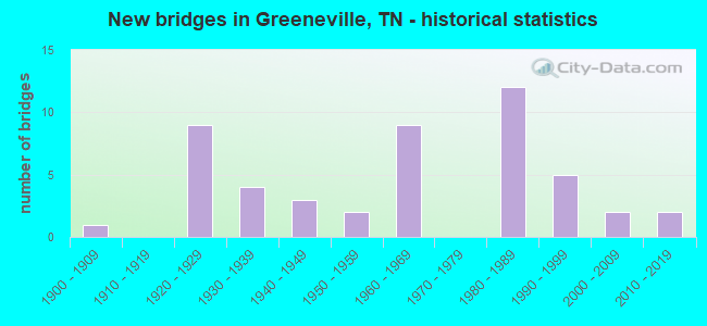
- New bridges - historical statistics
- 11900-1909
- 91920-1929
- 41930-1939
- 31940-1949
- 21950-1959
- 91960-1969
- 121980-1989
- 51990-1999
- 22000-2009
- 22010-2019
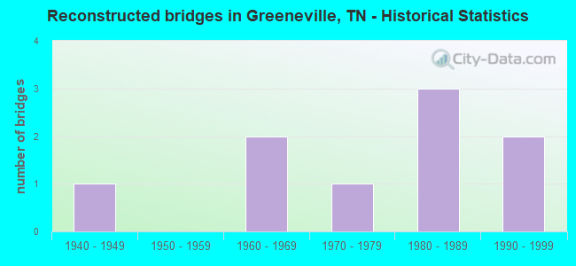
- Reconstructed bridges - Historical Statistics
- 11940-1949
- 01950-1959
- 21960-1969
- 11970-1979
- 31980-1989
- 21990-1999
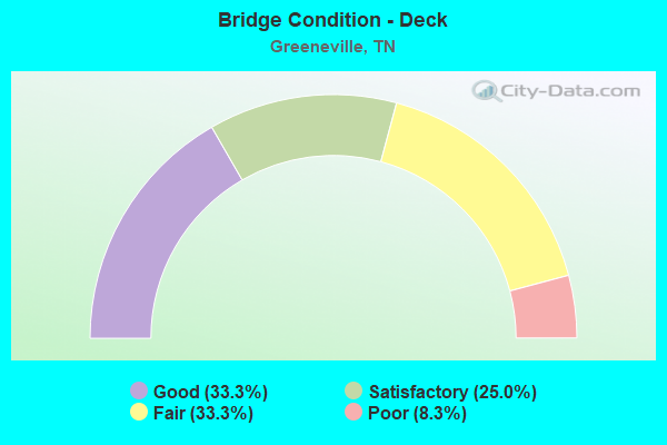
- Bridge Condition - Deck
- 33.3%Good
- 25.0%Satisfactory
- 33.3%Fair
- 8.3%Poor
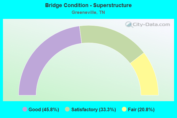
- Bridge Condition - Superstructure
- 45.8%Good
- 33.3%Satisfactory
- 20.8%Fair
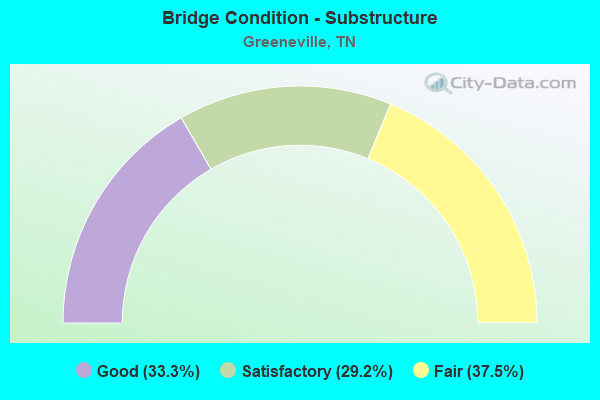
- Bridge Condition - Substructure
- 33.3%Good
- 29.2%Satisfactory
- 37.5%Fair
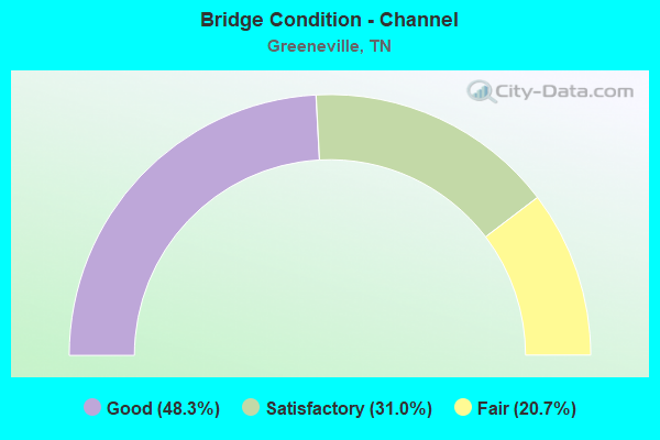
- Bridge Condition - Channel
- 48.3%Good
- 31.0%Satisfactory
- 20.7%Fair
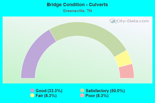
- Bridge Condition - Culverts
- 33.3%Good
- 50.0%Satisfactory
- 8.3%Fair
- 8.3%Poor
Find on map >> Show street view
Structure Number: 30SR0345001, Location: IN GREENVILLE (Lat: 36.164033, Lng: -82.836567), Route carried "under" structure: Business US 11, Year Built: 1930, Structure Length: 0. m, Average Daily Traffic: 5,244 (year 2020), Truck Traffic: 4%, Features Intersected: STATE ROUTE 350, Facility Carried by Structure: RALROAD ST.
Minimum Vertical Clearance: 4.27m (14.01ft), Kilometerpoint: 9.640, Lanes on structure: 2, Lanes under structure: 2, Material/Design: Concrete, Design/Construction: Tee Beam, Length of Maximum Span: 13.1m (43.0ft)
Find on map >> Show street view
Structure Number: 30SR0930001, Location: NEAR GREENEVILLE TENN. (Lat: 36.170250, Lng: -82.826833), Route carried "under" structure: US 411, Year Built: 1900, Structure Length: 0. m, Average Daily Traffic: 6,347 (year 2020), Truck Traffic: 9%, Features Intersected: SOUTHERN RAILWAY, Facility Carried by Structure: SOU RWY 731263G
Minimum Vertical Clearance: 4.42m (14.50ft), Kilometerpoint: 22.467, Lanes under structure: 4, Material/Design: Steel, Design/Construction: Stringer/Multi-beam, Length of Maximum Span: 12.5m (41.0ft)
Find on map >> Show street view
Structure Number: 30SR3500001, Location: DOWNTOWN GREENVILLE (Lat: 36.164000, Lng: -82.836450), Route carried "under" structure: State highway 350, Year Built: 1920, Structure Length: 0. m, Average Daily Traffic: 5,244 (year 2020), Truck Traffic: 4%, Features Intersected: NORFOLK SOUTHERN RR, Facility Carried by Structure: NORFOLK SOU
Minimum Vertical Clearance: 5.26m (17.26ft), Kilometerpoint: 9.608, Lanes under structure: 2, Material/Design: Steel, Design/Construction: Stringer/Multi-beam, Length of Maximum Span: 9.8m (32.2ft)
Find on map >> Show street view
Structure Number: 30SR3500003, Location: DOWNTOWN GREENVILLE (Lat: 36.164017, Lng: -82.836433), Route carried "under" structure: State highway 350, Year Built: 1920, Structure Length: 0. m, Average Daily Traffic: 5,244 (year 2020), Truck Traffic: 4%, Features Intersected: SOUTHERN RAILWAY, Facility Carried by Structure: SOU RWY 731269X
Minimum Vertical Clearance: 4.67m (15.32ft), Kilometerpoint: 9.624, Lanes under structure: 2, Material/Design: Steel, Design/Construction: Stringer/Multi-beam, Length of Maximum Span: 9.8m (32.2ft)