Bridge Statistics for Greenfield, Wisconsin (WI)
Condition, Traffic, Stress, Structural Evaluation, Project Costs
- National Bridge Inventory (NBI) Statistics
- 73Number of bridges
- 1,132ft / 345mTotal length
- $35,460,000Total costs
- 2,974,698Total average daily traffic
- 87,033Total average daily truck traffic
- National Bridge Inventory (NBI) Registered Bridges for Greenfield
- No street view available for this location
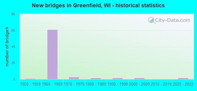
- New bridges - historical statistics
- 11950-1959
- 611960-1969
- 31970-1979
- 21980-1989
- 21990-1999
- 22000-2009
- 22020-2022
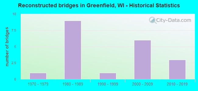
- Reconstructed bridges - Historical Statistics
- 11970-1979
- 91980-1989
- 11990-1999
- 62000-2009
- 32010-2019
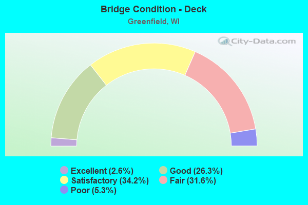
- Bridge Condition - Deck
- 2.6%Excellent
- 26.3%Good
- 34.2%Satisfactory
- 31.6%Fair
- 5.3%Poor

- Bridge Condition - Superstructure
- 2.6%Excellent
- 5.3%Very good
- 21.1%Good
- 21.1%Satisfactory
- 50.0%Fair
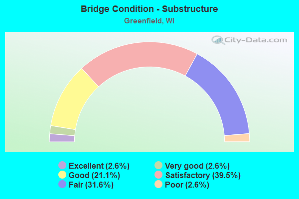
- Bridge Condition - Substructure
- 2.6%Excellent
- 2.6%Very good
- 21.1%Good
- 39.5%Satisfactory
- 31.6%Fair
- 2.6%Poor
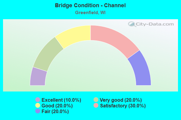
- Bridge Condition - Channel
- 10.0%Excellent
- 20.0%Very good
- 20.0%Good
- 30.0%Satisfactory
- 20.0%Fair
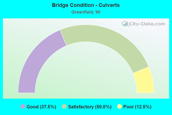
- Bridge Condition - Culverts
- 37.5%Good
- 50.0%Satisfactory
- 12.5%Poor
Find on map >> Show street view
Structure Number: B400013, Location: 0.4M E JCT STH 100 (Lat: 42.959161, Lng: -88.040131), Route carried "on" structure: County highway , Year Built: 2000, Status: Open, Structure Length: 3.53m (11.58ft), Average Daily Traffic: 14,100 (year 2019), Truck Traffic: 50%, Average Future Daily Traffic: 12,978 (year 2039), Design Load: HS 20, Features Intersected: ROOT RIVER, Facility Carried by Structure: CTH Y W. LAYTON
Minimum Vertical Clearance: 30+ m (98+ ft), Kilometerpoint: 0.000, Lanes on structure: 4, Owner: County Highway Agency, Approaching Roadway Width: 10.7m (35.1ft), Skew: 22 degrees, Material/Design: Concrete, Design/Construction: Slab, Number Of Spans In Main Unit: 2, Length of Maximum Span: 17.3m (56.8ft), Curb or Sidewalk Widths: Left: 2.3m (7.5ft), Right: 2.3m (7.5ft), Curb-To-Curb Width: 21.6m (70.9ft), Out-to-Out Width: 35.1m (115.2ft)
Condition: Deck: Satisfactory, Superstructure: Satisfactory, Substructure: Satisfactory, Channel: Good, Operating Rating: 65.0 metric tons, Method Used To Determine Operating Rating: Load Factor (LF), Inventory Rating: 38.9 metric tons, Method Used To Determine Inventory Rating: Load Factor (LF), Structural Evaluation: Equal to present minimum criteria, Deck Geometry: Superior to present desirable criteria, Waterway Adequacy: Equal to present desirable criteria, Approach Roadway Alignment: Equal to present desirable criteria, Designated Inspection Frequency: Every 24 months, Inspection Date: April 2020, Deck Structure Type: Concrete Cast-file-Place, Wearing Surface/Protective System: Wearing Surface: Monolithic Concrete, Deck Protection: Epoxy Coated Reinforcing
Find on map >> Show street view
Structure Number: B400077, Location: 1.2 MI E JCT IH 894 (Lat: 42.973347, Lng: -87.993311), Route carried "on" structure: State highway 24, Year Built: 1960, Status: Open, Structure Length: 0.97m (3.18ft), Average Daily Traffic: 14,000 (year 2019), Truck Traffic: 3%, Average Future Daily Traffic: 25,000 (year 2040), Design Load: HS 20, Features Intersected: HONEY CREEK
Minimum Vertical Clearance: 30+ m (98+ ft), Kilometerpoint: 0.000, Lanes on structure: 5, Owner: State Highway Agency, Approaching Roadway Width: 21.9m (71.9ft), Skew: 20 degrees, Material/Design: Concrete, Design/Construction: Tee Beam, Number Of Spans In Main Unit: 1, Length of Maximum Span: 9.6m (31.5ft), Curb or Sidewalk Widths: Left: 2.5m (8.2ft), Right: 2.0m (6.6ft), Curb-To-Curb Width: 21.9m (71.9ft), Out-to-Out Width: 34.3m (112.5ft)
Condition: Deck: Fair, Superstructure: Fair, Substructure: Fair, Channel: Very good, Operating Rating: 65.0 metric tons, Method Used To Determine Operating Rating: Load Factor (LF), Inventory Rating: 38.9 metric tons, Method Used To Determine Inventory Rating: Load Factor (LF), Structural Evaluation: Somewhat better than minimum adequacy, Deck Geometry: Somewhat better than minimum adequacy, Waterway Adequacy: Equal to present desirable criteria, Approach Roadway Alignment: Equal to present desirable criteria, Designated Inspection Frequency: Every 24 months, Inspection Date: September 2021, Deck Structure Type: Concrete Cast-file-Place, Wearing Surface/Protective System: Wearing Surface: Other
Find on map >> Show street view
Structure Number: B400115, Location: 0.4M N JCT STH 190 (Lat: 43.093314, Lng: -87.921825), Route carried "on" structure: Interstate 43, Year Built: 1962, Year Reconstructed: 1984, Status: Open, Structure Length: 44.75m (146.82ft), Average Daily Traffic: 132,000 (year 2019), Truck Traffic: 1%, Average Future Daily Traffic: 144,650 (year 2040), Design Load: HS 20+Mod, Features Intersected: LAND
Minimum Vertical Clearance: 30+ m (98+ ft), Kilometerpoint: 0.000, Lanes on structure: 6, Base Highway Network: Yes, Owner: State Highway Agency, Approaching Roadway Width: 29.9m (98.1ft), Skew: 33 degrees, Material/Design: Steel continuous, Design/Construction: Stringer/Multi-beam, Number Of Spans In Main Unit: 12, Length of Maximum Span: 48.5m (159.1ft), Curb-To-Curb Width: 29.9m (98.1ft), Out-to-Out Width: 31.7m (104.0ft)
Condition: Deck: Fair, Superstructure: Fair, Substructure: Fair, Operating Rating: 53.9 metric tons, Method Used To Determine Operating Rating: Load Factor (LF), Inventory Rating: 32.4 metric tons, Method Used To Determine Inventory Rating: Load Factor (LF), Structural Evaluation: Somewhat better than minimum adequacy, Deck Geometry: Superior to present desirable criteria, Underclear: Equal to present minimum criteria, Approach Roadway Alignment: Equal to present desirable criteria, Designated Inspection Frequency: Every 24 months, Other Special Inspection Frequency: Every 72 months, Inspection Date: March 2021, Other Special Inspection Date: October 2017, Deck Structure Type: Concrete Cast-file-Place, Wearing Surface/Protective System: Wearing Surface: Monolithic Concrete, Deck Protection: Epoxy Coated Reinforcing
Find on map >> Show street view
Structure Number: B400118, Location: 0.5 MI E JCT STH 100 (Lat: 42.979625, Lng: -88.039517), Route carried "on" structure: County highway T, Year Built: 1962, Year Reconstructed: 1986, Status: Open, Structure Length: 8.35m (27.40ft), Average Daily Traffic: 21,600 (year 2019), Average Future Daily Traffic: 21,600 (year 2040), Design Load: HS 20, Features Intersected: IH 41/IH 894/USH 45
Minimum Vertical Clearance: 30+ m (98+ ft), Kilometerpoint: 0.000, Lanes on structure: 6, Lanes under structure: 8, Base Highway Network: Yes, Owner: State Highway Agency, Approaching Roadway Width: 21.9m (71.9ft), Skew: 33 degrees, Material/Design: Steel continuous, Design/Construction: Stringer/Multi-beam, Number Of Spans In Main Unit: 4, Length of Maximum Span: 28.7m (94.2ft), Curb or Sidewalk Widths: Left: 2.0m (6.6ft), Right: 2.0m (6.6ft), Curb-To-Curb Width: 21.9m (71.9ft), Out-to-Out Width: 32.9m (107.9ft)
Condition: Deck: Fair, Superstructure: Good, Substructure: Fair, Operating Rating: 41.0 metric tons, Method Used To Determine Operating Rating: Load Factor (LF), Inventory Rating: 24.3 metric tons, Method Used To Determine Inventory Rating: Load Factor (LF), Structural Evaluation: Somewhat better than minimum adequacy, Deck Geometry: High priority of corrective action, Underclear: High priority of replacement, Approach Roadway Alignment: Equal to present desirable criteria, Length Of Structure Improvement: 8.81m (28.90ft), Designated Inspection Frequency: Every 24 months, Other Special Inspection Frequency: Every 72 months, Inspection Date: October 2021, Other Special Inspection Date: June 2016, Bridge Improvement Cost: $1,404,000, Roadway Improvement Cost: $140,000, Total Project Cost: $2,106,000 ( Estimate for 2021), Deck Structure Type: Concrete Cast-file-Place, Wearing Surface/Protective System: Wearing Surface: Low Slump Concrete, Deck Protection: Epoxy Coated Reinforcing
Find on map >> Show street view
Structure Number: B400159, Location: 1.4 MI E JCT USH 45 (Lat: 42.950489, Lng: -88.028108), Route carried "on" structure: State highway 24, Year Built: 1963, Status: Open, Structure Length: 1.65m (5.41ft), Average Daily Traffic: 18,300 (year 2019), Truck Traffic: 3%, Average Future Daily Traffic: 19,430 (year 2040), Design Load: HS 20, Features Intersected: ROOT RIVER
Minimum Vertical Clearance: 30+ m (98+ ft), Kilometerpoint: 0.000, Lanes on structure: 4, Base Highway Network: Yes, Owner: State Highway Agency, Approaching Roadway Width: 21.9m (71.9ft), Skew: 30 degrees, Material/Design: Concrete continuous, Design/Construction: Frame, Number Of Spans In Main Unit: 1, Length of Maximum Span: 15.9m (52.2ft), Curb or Sidewalk Widths: Left: 2.0m (6.6ft), Right: 2.0m (6.6ft), Curb-To-Curb Width: 21.9m (71.9ft), Out-to-Out Width: 33.5m (109.9ft)
Condition: Deck: Fair, Superstructure: Fair, Substructure: Satisfactory, Channel: Satisfactory, Operating Rating: 68.6 metric tons, Method Used To Determine Operating Rating: Load Factor (LF), Inventory Rating: 40.5 metric tons, Method Used To Determine Inventory Rating: Load Factor (LF), Structural Evaluation: Somewhat better than minimum adequacy, Deck Geometry: Superior to present desirable criteria, Waterway Adequacy: Equal to present desirable criteria, Approach Roadway Alignment: Equal to present desirable criteria, Designated Inspection Frequency: Every 24 months, Inspection Date: August 2021, Deck Structure Type: Concrete Cast-file-Place, Wearing Surface/Protective System: Wearing Surface: Bituminous
Find on map >> Show street view
Structure Number: B400162, Location: 0.5M E JCT STH 100 (Lat: 43.119167, Lng: -88.046847), Route carried "on" structure: County highway , Year Built: 1964, Year Reconstructed: 2009, Status: Open, Structure Length: 3.85m (12.63ft), Average Daily Traffic: 32,000 (year 2019), Average Future Daily Traffic: 20,528 (year 2039), Design Load: HS 20, Features Intersected: LITTLE MENOMONEE RIVER, Facility Carried by Structure: CTH SILVER SPRING
Minimum Vertical Clearance: 30+ m (98+ ft), Kilometerpoint: 0.000, Lanes on structure: 2, Base Highway Network: Yes, Owner: County Highway Agency, Approaching Roadway Width: 11.0m (36.1ft), Material/Design: Concrete continuous, Design/Construction: Slab, Number Of Spans In Main Unit: 3, Length of Maximum Span: 15.5m (50.9ft), Curb or Sidewalk Widths: Left: 0.0m, Right: 3.0m (9.8ft), Curb-To-Curb Width: 11.0m (36.1ft), Out-to-Out Width: 15.1m (49.5ft)
Condition: Deck: Satisfactory, Superstructure: Satisfactory, Substructure: Good, Channel: Very good, Operating Rating: 47.4 metric tons, Method Used To Determine Operating Rating: Load Factor (LF), Inventory Rating: 27.5 metric tons, Method Used To Determine Inventory Rating: Load Factor (LF), Structural Evaluation: Equal to present minimum criteria, Deck Geometry: Equal to present minimum criteria, Waterway Adequacy: Equal to present desirable criteria, Approach Roadway Alignment: Equal to present desirable criteria, Designated Inspection Frequency: Every 24 months, Inspection Date: April 2020, Deck Structure Type: Concrete Cast-file-Place, Wearing Surface/Protective System: Wearing Surface: Low Slump Concrete
Find on map >> Show street view
Structure Number: B400163, Location: 0.3M W JCT CTH U (Lat: 42.959106, Lng: -88.016503), Route carried "on" structure: County highway , Year Built: 1963, Year Reconstructed: 2000, Status: Open, Structure Length: 8.32m (27.30ft), Average Daily Traffic: 24,400 (year 2019), Average Future Daily Traffic: 28,749 (year 2039), Design Load: HS 20, Features Intersected: STH 24-FOREST HOME AVE, Facility Carried by Structure: CTH Y W LAYTON A
Minimum Vertical Clearance: 30+ m (98+ ft), Kilometerpoint: 0.000, Lanes on structure: 7, Lanes under structure: 4, Base Highway Network: Yes, Owner: County Highway Agency, Approaching Roadway Width: 21.9m (71.9ft), Skew: 35 degrees, Material/Design: Steel continuous, Design/Construction: Stringer/Multi-beam, Number Of Spans In Main Unit: 4, Length of Maximum Span: 22.9m (75.1ft), Curb or Sidewalk Widths: Left: 2.0m (6.6ft), Right: 2.0m (6.6ft), Curb-To-Curb Width: 28.0m (91.9ft), Out-to-Out Width: 39.6m (129.9ft)
Condition: Deck: Satisfactory, Superstructure: Good, Substructure: Fair, Operating Rating: 65.0 metric tons, Method Used To Determine Operating Rating: Load Factor (LF), Inventory Rating: 38.9 metric tons, Method Used To Determine Inventory Rating: Load Factor (LF), Structural Evaluation: Somewhat better than minimum adequacy, Deck Geometry: Somewhat better than minimum adequacy, Underclear: Meets minimum limits, Approach Roadway Alignment: Equal to present desirable criteria, Designated Inspection Frequency: Every 24 months, Inspection Date: April 2020, Deck Structure Type: Concrete Cast-file-Place, Wearing Surface/Protective System: Wearing Surface: Monolithic Concrete, Deck Protection: Epoxy Coated Reinforcing
Find on map >> Show street view
Structure Number: B400164, Location: 0.2M N JCT CTH Y (Lat: 42.963439, Lng: -88.008042), Route carried "on" structure: County highway , Year Built: 1963, Year Reconstructed: 2007, Status: Open, Structure Length: 7.79m (25.56ft), Average Daily Traffic: 23,700 (year 2019), Truck Traffic: 14%, Average Future Daily Traffic: 34,992 (year 2039), Design Load: HS 20, Features Intersected: STH 24-FOREST HOME AVE, Facility Carried by Structure: CTH U S 76TH ST
Minimum Vertical Clearance: 30+ m (98+ ft), Kilometerpoint: 0.000, Lanes on structure: 6, Lanes under structure: 4, Base Highway Network: Yes, Owner: County Highway Agency, Approaching Roadway Width: 21.9m (71.9ft), Skew: 24 degrees, Material/Design: Steel continuous, Design/Construction: Stringer/Multi-beam, Number Of Spans In Main Unit: 4, Length of Maximum Span: 21.3m (69.9ft), Curb or Sidewalk Widths: Left: 2.0m (6.6ft), Right: 2.0m (6.6ft), Curb-To-Curb Width: 21.9m (71.9ft), Out-to-Out Width: 33.5m (109.9ft)
Condition: Deck: Satisfactory, Superstructure: Good, Substructure: Fair, Operating Rating: 45.7 metric tons, Method Used To Determine Operating Rating: Load Factor (LF), Inventory Rating: 27.5 metric tons, Method Used To Determine Inventory Rating: Load Factor (LF), Structural Evaluation: Somewhat better than minimum adequacy, Deck Geometry: High priority of corrective action, Underclear: Meets minimum limits, Approach Roadway Alignment: Equal to present desirable criteria, Length Of Structure Improvement: 8.23m (27.00ft), Designated Inspection Frequency: Every 24 months, Inspection Date: April 2020, Bridge Improvement Cost: $1,315,000, Roadway Improvement Cost: $131,000, Total Project Cost: $1,973,000 ( Estimate for 2021), Deck Structure Type: Concrete Cast-file-Place, Wearing Surface/Protective System: Wearing Surface: Monolithic Concrete, Deck Protection: Epoxy Coated Reinforcing
Find on map >> Show street view
Structure Number: B400165, Location: 2.4M E JCT USH 45 (Lat: 42.961281, Lng: -88.011897), Route carried "on" structure: State highway 24, Year Built: 1963, Year Reconstructed: 2010, Status: Open, Structure Length: 10.49m (34.42ft), Average Daily Traffic: 14,300 (year 2019), Truck Traffic: 3%, Average Future Daily Traffic: 8,774 (year 2039), Design Load: HS 25 or greater, Features Intersected: IH 41/43/894
Minimum Vertical Clearance: 30+ m (98+ ft), Kilometerpoint: 0.000, Lanes on structure: 3, Lanes under structure: 7, Base Highway Network: Yes, Owner: State Highway Agency, Approaching Roadway Width: 12.2m (40.0ft), Skew: 5 degrees, Material/Design: Steel continuous, Design/Construction: Stringer/Multi-beam, Number Of Spans In Main Unit: 4, Length of Maximum Span: 31.4m (103.0ft), Curb-To-Curb Width: 12.8m (42.0ft), Out-to-Out Width: 13.7m (44.9ft)
Condition: Deck: Good, Superstructure: Good, Substructure: Good, Operating Rating: 58.8 metric tons, Method Used To Determine Operating Rating: Load Factor (LF), Inventory Rating: 34.0 metric tons, Method Used To Determine Inventory Rating: Load Factor (LF), Structural Evaluation: Better than present minimum criteria, Deck Geometry: Meets minimum limits, Underclear: Meets minimum limits, Approach Roadway Alignment: Equal to present desirable criteria, Designated Inspection Frequency: Every 24 months, Inspection Date: July 2020, Deck Structure Type: Concrete Cast-file-Place, Wearing Surface/Protective System: Wearing Surface: Epoxy Overlay, Deck Protection: Epoxy Coated Reinforcing
Find on map >> Show street view
Structure Number: B400166, Location: 0.5 MI W JCT CTH U (Lat: 42.961889, Lng: -88.012044), Route carried "on" structure: Ramp Interstate 41, Year Built: 1963, Year Reconstructed: 2010, Status: Open, Structure Length: 8.20m (26.90ft), Average Daily Traffic: 3,700 (year 2019), Truck Traffic: 1%, Average Future Daily Traffic: 123,530 (year 2039), Design Load: HS 25 or greater, Features Intersected: IH 41/43/894
Minimum Vertical Clearance: 30+ m (98+ ft), Kilometerpoint: 0.000, Lanes on structure: 2, Lanes under structure: 7, Owner: State Highway Agency, Approaching Roadway Width: 8.5m (27.9ft), Skew: 3 degrees, Material/Design: Steel continuous, Design/Construction: Stringer/Multi-beam, Number Of Spans In Main Unit: 4, Length of Maximum Span: 24.6m (80.7ft), Curb or Sidewalk Widths: Left: 0.0m, Right: 2.0m (6.6ft), Curb-To-Curb Width: 8.5m (27.9ft), Out-to-Out Width: 11.4m (37.4ft)
Condition: Deck: Good, Superstructure: Good, Substructure: Good, Operating Rating: 42.5 metric tons, Method Used To Determine Operating Rating: Load Factor (LF), Inventory Rating: 25.9 metric tons, Method Used To Determine Inventory Rating: Load Factor (LF), Structural Evaluation: Equal to present minimum criteria, Deck Geometry: High priority of corrective action, Underclear: High priority of replacement, Approach Roadway Alignment: Equal to present desirable criteria, Length Of Structure Improvement: 8.66m (28.41ft), Designated Inspection Frequency: Every 24 months, Inspection Date: July 2020, Bridge Improvement Cost: $1,073,000, Roadway Improvement Cost: $107,000, Total Project Cost: $1,610,000 ( Estimate for 2021), Deck Structure Type: Concrete Cast-file-Place, Wearing Surface/Protective System: Wearing Surface: Epoxy Overlay, Deck Protection: Epoxy Coated Reinforcing
Find on map >> Show street view
Structure Number: B40018, Location: 0.95 MI N JCT OKLAHOMA AV (Lat: 43.000769, Lng: -87.915858), Route carried "on" structure: State highway 38, Year Built: 1967, Year Reconstructed: 2015, Status: Open, Structure Length: 10.03m (32.91ft), Average Daily Traffic: 6,200 (year 2018), Truck Traffic: 3%, Average Future Daily Traffic: 16,760 (year 2040), Design Load: HS 20, Features Intersected: IH 43/94
Minimum Vertical Clearance: 30+ m (98+ ft), Kilometerpoint: 0.000, Lanes on structure: 4, Lanes under structure: 6, Owner: State Highway Agency, Approaching Roadway Width: 16.5m (54.1ft), Skew: 6 degrees, Material/Design: Steel continuous, Design/Construction: Stringer/Multi-beam, Number Of Spans In Main Unit: 2, Length of Maximum Span: 48.8m (160.1ft), Curb or Sidewalk Widths: Left: 2.0m (6.6ft), Right: 2.0m (6.6ft), Curb-To-Curb Width: 16.5m (54.1ft), Out-to-Out Width: 20.7m (67.9ft)
Condition: Deck: Good, Superstructure: Good, Substructure: Good, Operating Rating: 50.6 metric tons, Method Used To Determine Operating Rating: Load Factor (LF), Inventory Rating: 29.2 metric tons, Method Used To Determine Inventory Rating: Load Factor (LF), Structural Evaluation: Better than present minimum criteria, Deck Geometry: Meets minimum limits, Underclear: High priority of replacement, Approach Roadway Alignment: Equal to present desirable criteria, Length Of Structure Improvement: 10.49m (34.42ft), Designated Inspection Frequency: Every 24 months, Inspection Date: October 2021, Bridge Improvement Cost: $1,672,000, Roadway Improvement Cost: $167,000, Total Project Cost: $2,509,000 ( Estimate for 2021), Deck Structure Type: Concrete Cast-file-Place, Wearing Surface/Protective System: Wearing Surface: Monolithic Concrete, Deck Protection: Epoxy Coated Reinforcing
Find on map >> Show street view
Structure Number: B400186, Location: 3.6M E JCT STH 59 TO E (Lat: 42.966636, Lng: -88.038708), Route carried "on" structure: Interstate 41, Year Built: 1964, Year Reconstructed: 1991, Status: Open, Structure Length: 4.33m (14.21ft), Average Daily Traffic: 71,000 (year 2019), Truck Traffic: 1%, Average Future Daily Traffic: 64,200 (year 2039), Design Load: HS 20, Features Intersected: LRD W COLD SPRING RD
Minimum Vertical Clearance: 30+ m (98+ ft), Kilometerpoint: 0.000, Lanes on structure: 4, Lanes under structure: 2, Base Highway Network: Yes, Owner: State Highway Agency, Approaching Roadway Width: 12.2m (40.0ft), Material/Design: Steel continuous, Design/Construction: Stringer/Multi-beam, Number Of Spans In Main Unit: 3, Length of Maximum Span: 18.5m (60.7ft), Curb-To-Curb Width: 18.0m (59.1ft), Out-to-Out Width: 18.9m (62.0ft)
Condition: Deck: Satisfactory, Superstructure: Very good, Substructure: Satisfactory, Operating Rating: 57.0 metric tons, Method Used To Determine Operating Rating: Load Factor (LF), Inventory Rating: 34.0 metric tons, Method Used To Determine Inventory Rating: Load Factor (LF), Structural Evaluation: Equal to present minimum criteria, Deck Geometry: Meets minimum limits, Underclear: Equal to present minimum criteria, Approach Roadway Alignment: Equal to present desirable criteria, Designated Inspection Frequency: Every 24 months, Inspection Date: June 2020, Deck Structure Type: Concrete Cast-file-Place, Wearing Surface/Protective System: Wearing Surface: Other, Deck Protection: Epoxy Coated Reinforcing
Find on map >> Show street view
Structure Number: B400188, Location: 0.1M E JCT USH 45 TO S (Lat: 42.963683, Lng: -88.037889), Route carried "on" structure: Interstate 41, Year Built: 1966, Year Reconstructed: 1998, Status: Open, Structure Length: 19.60m (64.30ft), Average Daily Traffic: 41,300 (year 2019), Truck Traffic: 1%, Average Future Daily Traffic: 44,600 (year 2039), Design Load: HS 20, Features Intersected: IH RAMP IH 43 NB TO IH 4
Minimum Vertical Clearance: 30+ m (98+ ft), Kilometerpoint: 0.000, Lanes on structure: 3, Lanes under structure: 2, Base Highway Network: Yes, Owner: State Highway Agency, Approaching Roadway Width: 11.9m (39.0ft), Skew: 1 degrees, Material/Design: Steel continuous, Design/Construction: Stringer/Multi-beam, Number Of Spans In Main Unit: 8, Length of Maximum Span: 26.8m (87.9ft), Curb-To-Curb Width: 12.0m (39.4ft), Out-to-Out Width: 12.8m (42.0ft)
Condition: Deck: Good, Superstructure: Good, Substructure: Good, Operating Rating: 52.3 metric tons, Method Used To Determine Operating Rating: Load Factor (LF), Inventory Rating: 30.8 metric tons, Method Used To Determine Inventory Rating: Load Factor (LF), Structural Evaluation: Better than present minimum criteria, Deck Geometry: High priority of corrective action, Underclear: Somewhat better than minimum adequacy, Approach Roadway Alignment: Equal to present desirable criteria, Length Of Structure Improvement: 20.03m (65.72ft), Designated Inspection Frequency: Every 24 months, Inspection Date: July 2020, Bridge Improvement Cost: $2,486,000, Roadway Improvement Cost: $248,000, Total Project Cost: $3,730,000 ( Estimate for 2021), Deck Structure Type: Concrete Cast-file-Place, Wearing Surface/Protective System: Wearing Surface: Epoxy Overlay, Deck Protection: Epoxy Coated Reinforcing
Find on map >> Show street view
Structure Number: B400189, Location: 0.8M N JCT STH 100 TO N (Lat: 42.963242, Lng: -88.037542), Route carried "on" structure: Ramp Interstate 41, Year Built: 1966, Status: Open, Structure Length: 3.49m (11.45ft), Average Daily Traffic: 21,100 (year 2019), Truck Traffic: 3%, Average Future Daily Traffic: 19,700 (year 2039), Design Load: HS 20, Features Intersected: IH 43 SB, Facility Carried by Structure: IH RAMP IH43 NB/US
Minimum Vertical Clearance: 5.00m (16.40ft), Kilometerpoint: 0.000, Lanes on structure: 2, Lanes under structure: 1, Owner: State Highway Agency, Approaching Roadway Width: 10.7m (35.1ft), Skew: 2 degrees, Material/Design: Concrete continuous, Design/Construction: Slab, Number Of Spans In Main Unit: 3, Length of Maximum Span: 13.0m (42.7ft), Curb-To-Curb Width: 10.9m (35.8ft), Out-to-Out Width: 11.8m (38.7ft)
Condition: Deck: Fair, Superstructure: Fair, Substructure: Fair, Operating Rating: 42.5 metric tons, Method Used To Determine Operating Rating: Load Factor (LF), Inventory Rating: 25.9 metric tons, Method Used To Determine Inventory Rating: Load Factor (LF), Structural Evaluation: Somewhat better than minimum adequacy, Deck Geometry: Somewhat better than minimum adequacy, Underclear: Meets minimum limits, Approach Roadway Alignment: Equal to present desirable criteria, Designated Inspection Frequency: Every 24 months, Inspection Date: July 2020, Deck Structure Type: Concrete Cast-file-Place, Wearing Surface/Protective System: Wearing Surface: Low Slump Concrete
Find on map >> Show street view
Structure Number: B40019, Location: 0.2 MI N JCT CTH Y (Lat: 42.961553, Lng: -88.028031), Route carried "on" structure: City street , Year Built: 1964, Status: Open, Structure Length: 6.47m (21.23ft), Average Daily Traffic: 6,900 (year 2019), Average Future Daily Traffic: 6,900 (year 2039), Design Load: HS 20, Features Intersected: IH 41/43/894, Facility Carried by Structure: LRD S 92ND ST
Minimum Vertical Clearance: 30+ m (98+ ft), Kilometerpoint: 0.000, Lanes on structure: 2, Lanes under structure: 6, Owner: State Highway Agency, Approaching Roadway Width: 12.2m (40.0ft), Material/Design: Prestressed concrete, Design/Construction: Stringer/Multi-beam, Number Of Spans In Main Unit: 4, Length of Maximum Span: 19.7m (64.6ft), Curb or Sidewalk Widths: Left: 0.0m, Right: 2.0m (6.6ft), Curb-To-Curb Width: 11.0m (36.1ft), Out-to-Out Width: 13.9m (45.6ft)
Condition: Deck: Poor, Superstructure: Fair, Substructure: Fair, Operating Rating: 52.3 metric tons, Method Used To Determine Operating Rating: Load Factor (LF), Inventory Rating: 30.8 metric tons, Method Used To Determine Inventory Rating: Load Factor (LF), Structural Evaluation: Somewhat better than minimum adequacy, Deck Geometry: Meets minimum limits, Underclear: Meets minimum limits, Approach Roadway Alignment: Equal to present desirable criteria, Length Of Structure Improvement: 6.92m (22.70ft), Designated Inspection Frequency: Every 24 months, Inspection Date: March 2020, Bridge Improvement Cost: $1,105,000, Roadway Improvement Cost: $110,000, Total Project Cost: $1,657,000 ( Estimate for 2021), Deck Structure Type: Concrete Cast-file-Place, Wearing Surface/Protective System: Wearing Surface: Low Slump Concrete
Find on map >> Show street view
Structure Number: B400191, Location: 1.4M N JCT USH 45 TO S (Lat: 42.961989, Lng: -88.018486), Route carried "on" structure: Interstate 41, Year Built: 1966, Year Reconstructed: 1994, Status: Open, Structure Length: 5.84m (19.16ft), Average Daily Traffic: 60,500 (year 2019), Truck Traffic: 1%, Average Future Daily Traffic: 61,765 (year 2039), Design Load: HS 20+Mod, Features Intersected: LRD S 84TH ST
Minimum Vertical Clearance: 30+ m (98+ ft), Kilometerpoint: 0.000, Lanes on structure: 3, Lanes under structure: 4, Base Highway Network: Yes, Owner: State Highway Agency, Approaching Roadway Width: 16.8m (55.1ft), Material/Design: Prestressed concrete continuous, Design/Construction: Stringer/Multi-beam, Number Of Spans In Main Unit: 4, Length of Maximum Span: 17.6m (57.7ft), Curb-To-Curb Width: 18.0m (59.1ft), Out-to-Out Width: 19.4m (63.6ft)
Condition: Deck: Satisfactory, Superstructure: Satisfactory, Substructure: Satisfactory, Operating Rating: 70.2 metric tons, Method Used To Determine Operating Rating: Load Factor (LF), Inventory Rating: 43.7 metric tons, Method Used To Determine Inventory Rating: Load Factor (LF), Structural Evaluation: Equal to present minimum criteria, Deck Geometry: Better than present minimum criteria, Underclear: High priority of replacement, Approach Roadway Alignment: Equal to present desirable criteria, Length Of Structure Improvement: 6.28m (20.60ft), Designated Inspection Frequency: Every 24 months, Inspection Date: March 2020, Bridge Improvement Cost: $781,000, Roadway Improvement Cost: $78,000, Total Project Cost: $1,171,000 ( Estimate for 2021), Deck Structure Type: Concrete Cast-file-Place, Wearing Surface/Protective System: Wearing Surface: Monolithic Concrete, Deck Protection: Epoxy Coated Reinforcing
Find on map >> Show street view
Structure Number: B400192, Location: 0.2M S JCT STH 24 TO W (Lat: 42.962253, Lng: -88.017772), Route carried "on" structure: Interstate 41, Year Built: 1966, Year Reconstructed: 1994, Status: Open, Structure Length: 5.84m (19.16ft), Average Daily Traffic: 60,500 (year 2019), Truck Traffic: 1%, Average Future Daily Traffic: 73,703 (year 2039), Design Load: HS 20+Mod, Features Intersected: LRD S 84TH ST
Minimum Vertical Clearance: 30+ m (98+ ft), Kilometerpoint: 0.000, Lanes on structure: 3, Lanes under structure: 4, Base Highway Network: Yes, Owner: State Highway Agency, Approaching Roadway Width: 14.0m (45.9ft), Material/Design: Prestressed concrete continuous, Design/Construction: Stringer/Multi-beam, Number Of Spans In Main Unit: 4, Length of Maximum Span: 17.6m (57.7ft), Curb-To-Curb Width: 18.0m (59.1ft), Out-to-Out Width: 19.4m (63.6ft)
Condition: Deck: Satisfactory, Superstructure: Satisfactory, Substructure: Satisfactory, Operating Rating: 70.2 metric tons, Method Used To Determine Operating Rating: Load Factor (LF), Inventory Rating: 43.7 metric tons, Method Used To Determine Inventory Rating: Load Factor (LF), Structural Evaluation: Equal to present minimum criteria, Deck Geometry: Better than present minimum criteria, Underclear: High priority of replacement, Approach Roadway Alignment: Equal to present desirable criteria, Length Of Structure Improvement: 6.28m (20.60ft), Designated Inspection Frequency: Every 24 months, Inspection Date: March 2020, Bridge Improvement Cost: $781,000, Roadway Improvement Cost: $78,000, Total Project Cost: $1,171,000 ( Estimate for 2021), Deck Structure Type: Concrete Cast-file-Place, Wearing Surface/Protective System: Wearing Surface: Monolithic Concrete, Deck Protection: Epoxy Coated Reinforcing
Find on map >> Show street view
Structure Number: B400193, Location: 0.1M N JCT CTH Y (Lat: 42.961558, Lng: -88.008078), Route carried "on" structure: County highway U, Year Built: 1966, Year Reconstructed: 2007, Status: Open, Structure Length: 6.48m (21.26ft), Average Daily Traffic: 25,400 (year 2019), Average Future Daily Traffic: 25,400 (year 2040), Design Load: HS 20, Features Intersected: IH 41/43/894
Minimum Vertical Clearance: 30+ m (98+ ft), Kilometerpoint: 0.000, Lanes on structure: 6, Lanes under structure: 6, Base Highway Network: Yes, Owner: State Highway Agency, Approaching Roadway Width: 24.7m (81.0ft), Skew: 31 degrees, Material/Design: Prestressed concrete, Design/Construction: Stringer/Multi-beam, Number Of Spans In Main Unit: 4, Length of Maximum Span: 19.7m (64.6ft), Curb or Sidewalk Widths: Left: 2.0m (6.6ft), Right: 2.0m (6.6ft), Curb-To-Curb Width: 22.6m (74.1ft), Out-to-Out Width: 33.5m (109.9ft)
Condition: Deck: Good, Superstructure: Fair, Substructure: Satisfactory, Operating Rating: 29.4 metric tons, Method Used To Determine Operating Rating: Load Factor (LF), Inventory Rating: 16.2 metric tons, Method Used To Determine Inventory Rating: Load Factor (LF), Structural Evaluation: Meets minimum limits, Deck Geometry: Meets minimum limits, Underclear: High priority of replacement, Approach Roadway Alignment: Equal to present desirable criteria, Length Of Structure Improvement: 6.92m (22.70ft), Designated Inspection Frequency: Every 24 months, Inspection Date: July 2021, Bridge Improvement Cost: $1,106,000, Roadway Improvement Cost: $110,000, Total Project Cost: $1,659,000 ( Estimate for 2021), Deck Structure Type: Concrete Cast-file-Place, Wearing Surface/Protective System: Wearing Surface: Epoxy Overlay, Deck Protection: Epoxy Coated Reinforcing
Find on map >> Show street view
Structure Number: B400196, Location: 3.2M N JCT USH 45 TO S (Lat: 42.962497, Lng: -87.978725), Route carried "on" structure: Interstate 41, Year Built: 1966, Year Reconstructed: 1994, Status: Open, Structure Length: 4.41m (14.47ft), Average Daily Traffic: 75,000 (year 2019), Truck Traffic: 1%, Average Future Daily Traffic: 74,576 (year 2039), Design Load: HS 20+Mod, Features Intersected: LRD S 51ST ST
Minimum Vertical Clearance: 30+ m (98+ ft), Kilometerpoint: 0.000, Lanes on structure: 3, Lanes under structure: 2, Base Highway Network: Yes, Owner: State Highway Agency, Approaching Roadway Width: 17.4m (57.1ft), Material/Design: Steel continuous, Design/Construction: Stringer/Multi-beam, Number Of Spans In Main Unit: 3, Length of Maximum Span: 18.8m (61.7ft), Curb-To-Curb Width: 17.4m (57.1ft), Out-to-Out Width: 18.8m (61.7ft)
Condition: Deck: Good, Superstructure: Fair, Substructure: Fair, Operating Rating: 55.5 metric tons, Method Used To Determine Operating Rating: Load Factor (LF), Inventory Rating: 32.4 metric tons, Method Used To Determine Inventory Rating: Load Factor (LF), Structural Evaluation: Somewhat better than minimum adequacy, Deck Geometry: Better than present minimum criteria, Underclear: Equal to present minimum criteria, Approach Roadway Alignment: Equal to present desirable criteria, Designated Inspection Frequency: Every 24 months, Other Special Inspection Frequency: Every 96 months, Inspection Date: June 2020, Other Special Inspection Date: July 2017, Deck Structure Type: Concrete Cast-file-Place, Wearing Surface/Protective System: Wearing Surface: Monolithic Concrete, Deck Protection: Epoxy Coated Reinforcing
Find on map >> Show street view
Structure Number: B400197, Location: 0.4M S JCT STH 36 TO N (Lat: 42.962825, Lng: -87.978181), Route carried "on" structure: Interstate 41, Year Built: 1966, Year Reconstructed: 1994, Status: Open, Structure Length: 4.41m (14.47ft), Average Daily Traffic: 75,000 (year 2019), Truck Traffic: 1%, Average Future Daily Traffic: 89,225 (year 2039), Design Load: HS 20+Mod, Features Intersected: LRD S 51ST ST
Minimum Vertical Clearance: 30+ m (98+ ft), Kilometerpoint: 0.000, Lanes on structure: 3, Lanes under structure: 2, Base Highway Network: Yes, Owner: State Highway Agency, Approaching Roadway Width: 17.4m (57.1ft), Material/Design: Steel continuous, Design/Construction: Stringer/Multi-beam, Number Of Spans In Main Unit: 3, Length of Maximum Span: 18.8m (61.7ft), Curb-To-Curb Width: 17.4m (57.1ft), Out-to-Out Width: 18.8m (61.7ft)
Condition: Deck: Good, Superstructure: Fair, Substructure: Fair, Operating Rating: 53.9 metric tons, Method Used To Determine Operating Rating: Load Factor (LF), Inventory Rating: 30.8 metric tons, Method Used To Determine Inventory Rating: Load Factor (LF), Structural Evaluation: Somewhat better than minimum adequacy, Deck Geometry: Better than present minimum criteria, Underclear: Equal to present minimum criteria, Approach Roadway Alignment: Equal to present desirable criteria, Designated Inspection Frequency: Every 24 months, Other Special Inspection Frequency: Every 96 months, Inspection Date: June 2020, Other Special Inspection Date: July 2017, Deck Structure Type: Concrete Cast-file-Place, Wearing Surface/Protective System: Wearing Surface: Monolithic Concrete, Deck Protection: Epoxy Coated Reinforcing
Find on map >> Show street view
Structure Number: B400198, Location: 0.1M N JCT CTH Y (Lat: 42.961353, Lng: -87.968725), Route carried "on" structure: State highway 36, Year Built: 1966, Status: Open, Structure Length: 6.92m (22.70ft), Average Daily Traffic: 31,300 (year 2019), Truck Traffic: 6%, Average Future Daily Traffic: 25,200 (year 2040), Design Load: HS 20, Features Intersected: IH 41/43/894
Minimum Vertical Clearance: 30+ m (98+ ft), Kilometerpoint: 0.000, Lanes on structure: 6, Lanes under structure: 6, Base Highway Network: Yes, Owner: State Highway Agency, Approaching Roadway Width: 24.4m (80.1ft), Skew: 30 degrees, Material/Design: Steel continuous, Design/Construction: Stringer/Multi-beam, Number Of Spans In Main Unit: 4, Length of Maximum Span: 23.2m (76.1ft), Curb or Sidewalk Widths: Left: 0.0m, Right: 2.0m (6.6ft), Curb-To-Curb Width: 30.5m (100.1ft), Out-to-Out Width: 33.4m (109.6ft)
Condition: Deck: Poor, Superstructure: Fair, Substructure: Poor, Operating Rating: 52.3 metric tons, Method Used To Determine Operating Rating: Load Factor (LF), Inventory Rating: 30.8 metric tons, Method Used To Determine Inventory Rating: Load Factor (LF), Structural Evaluation: Meets minimum limits, Deck Geometry: Superior to present desirable criteria, Underclear: Meets minimum limits, Approach Roadway Alignment: Equal to present desirable criteria, Length Of Structure Improvement: 7.38m (24.21ft), Designated Inspection Frequency: Every 12 months, Inspection Date: June 2021, Bridge Improvement Cost: $1,176,000, Roadway Improvement Cost: $117,000, Total Project Cost: $1,764,000 ( Estimate for 2021), Deck Structure Type: Concrete Cast-file-Place, Wearing Surface/Protective System: Wearing Surface: Low Slump Concrete
Find on map >> Show street view
Structure Number: B4002, Location: 0.9M S JCT STH 241 TO N (Lat: 42.961750, Lng: -87.963808), Route carried "on" structure: Interstate 41, Year Built: 1966, Year Reconstructed: 1994, Status: Open, Structure Length: 4.87m (15.98ft), Average Daily Traffic: 76,500 (year 2019), Truck Traffic: 1%, Average Future Daily Traffic: 74,035 (year 2039), Design Load: HS 20+Mod, Features Intersected: LRD PARKING LOT BUS RAMP
Minimum Vertical Clearance: 30+ m (98+ ft), Kilometerpoint: 0.000, Lanes on structure: 4, Lanes under structure: 1, Base Highway Network: Yes, Owner: State Highway Agency, Approaching Roadway Width: 17.1m (56.1ft), Skew: 4 degrees, Material/Design: Steel continuous, Design/Construction: Stringer/Multi-beam, Number Of Spans In Main Unit: 3, Length of Maximum Span: 21.9m (71.9ft), Curb-To-Curb Width: 17.1m (56.1ft), Out-to-Out Width: 18.3m (60.0ft)
Condition: Deck: Good, Superstructure: Fair, Substructure: Fair, Operating Rating: 76.7 metric tons, Method Used To Determine Operating Rating: Load Factor (LF), Inventory Rating: 45.4 metric tons, Method Used To Determine Inventory Rating: Load Factor (LF), Structural Evaluation: Somewhat better than minimum adequacy, Deck Geometry: High priority of corrective action, Underclear: Equal to present minimum criteria, Approach Roadway Alignment: Equal to present desirable criteria, Length Of Structure Improvement: 5.30m (17.39ft), Designated Inspection Frequency: Every 24 months, Other Special Inspection Frequency: Every 96 months, Inspection Date: June 2020, Other Special Inspection Date: July 2017, Bridge Improvement Cost: $660,000, Roadway Improvement Cost: $66,000, Total Project Cost: $990,000 ( Estimate for 2021), Deck Structure Type: Concrete Cast-file-Place, Wearing Surface/Protective System: Wearing Surface: Monolithic Concrete, Deck Protection: Epoxy Coated Reinforcing
Find on map >> Show street view
Structure Number: B4003, Location: 0.9 MI S JCT IH 894 (Lat: 42.956006, Lng: -88.049628), Route carried "on" structure: US 45, Year Built: 1965, Status: Open, Structure Length: 3.44m (11.29ft), Average Daily Traffic: 10,000 (year 2019), Truck Traffic: 3%, Average Future Daily Traffic: 11,128 (year 2040), Design Load: HS 20, Features Intersected: IH 43 NB, Facility Carried by Structure: USH RAMP, IH 43 SB
Minimum Vertical Clearance: 30+ m (98+ ft), Kilometerpoint: 0.000, Lanes on structure: 2, Lanes under structure: 2, Base Highway Network: Yes, Owner: State Highway Agency, Approaching Roadway Width: 11.9m (39.0ft), Material/Design: Concrete continuous, Design/Construction: Slab, Number Of Spans In Main Unit: 3, Length of Maximum Span: 14.5m (47.6ft), Curb-To-Curb Width: 11.9m (39.0ft), Out-to-Out Width: 12.8m (42.0ft)
Condition: Deck: Fair, Superstructure: Fair, Substructure: Satisfactory, Operating Rating: 50.6 metric tons, Method Used To Determine Operating Rating: Load Factor (LF), Inventory Rating: 29.2 metric tons, Method Used To Determine Inventory Rating: Load Factor (LF), Structural Evaluation: Somewhat better than minimum adequacy, Deck Geometry: Better than present minimum criteria, Underclear: High priority of replacement, Approach Roadway Alignment: Equal to present desirable criteria, Length Of Structure Improvement: 3.90m (12.80ft), Designated Inspection Frequency: Every 24 months, Inspection Date: September 2021, Bridge Improvement Cost: $622,000, Roadway Improvement Cost: $62,000, Total Project Cost: $933,000 ( Estimate for 2021), Deck Structure Type: Concrete Cast-file-Place, Wearing Surface/Protective System: Wearing Surface: Epoxy Overlay
Find on map >> Show street view
Structure Number: B400301, Location: 0.2M S JCT CTH Y (D) (Lat: 42.955750, Lng: -88.048214), Route carried "on" structure: State highway 100, Year Built: 1965, Status: Open, Structure Length: 3.44m (11.29ft), Average Daily Traffic: 12,900 (year 2019), Truck Traffic: 3%, Average Future Daily Traffic: 23,326 (year 2039), Design Load: HS 20, Features Intersected: IH 43 NB
Minimum Vertical Clearance: 30+ m (98+ ft), Kilometerpoint: 0.000, Lanes on structure: 2, Lanes under structure: 2, Base Highway Network: Yes, Owner: State Highway Agency, Approaching Roadway Width: 11.0m (36.1ft), Material/Design: Concrete continuous, Design/Construction: Slab, Number Of Spans In Main Unit: 3, Length of Maximum Span: 14.3m (46.9ft), Curb or Sidewalk Widths: Left: 0.0m, Right: 2.0m (6.6ft), Curb-To-Curb Width: 11.0m (36.1ft), Out-to-Out Width: 13.9m (45.6ft)
Condition: Deck: Fair, Superstructure: Fair, Substructure: Satisfactory, Operating Rating: 41.0 metric tons, Method Used To Determine Operating Rating: Load Factor (LF), Inventory Rating: 24.3 metric tons, Method Used To Determine Inventory Rating: Load Factor (LF), Structural Evaluation: Somewhat better than minimum adequacy, Deck Geometry: Equal to present minimum criteria, Underclear: High priority of replacement, Approach Roadway Alignment: Equal to present desirable criteria, Length Of Structure Improvement: 3.90m (12.80ft), Designated Inspection Frequency: Every 24 months, Inspection Date: March 2020, Bridge Improvement Cost: $622,000, Roadway Improvement Cost: $62,000, Total Project Cost: $933,000 ( Estimate for 2021), Deck Structure Type: Concrete Cast-file-Place, Wearing Surface/Protective System: Wearing Surface: Bituminous, Membrane: Other
Find on map >> Show street view
Structure Number: B400302, Location: 0.1M N JCT USH 45 (D) (Lat: 42.955442, Lng: -88.047819), Route carried "on" structure: State highway 100, Year Built: 1965, Status: Open, Structure Length: 3.44m (11.29ft), Average Daily Traffic: 12,900 (year 2019), Truck Traffic: 3%, Average Future Daily Traffic: 17,365 (year 2039), Design Load: HS 20, Features Intersected: IH 43 NB
Minimum Vertical Clearance: 30+ m (98+ ft), Kilometerpoint: 0.000, Lanes on structure: 2, Lanes under structure: 2, Base Highway Network: Yes, Owner: State Highway Agency, Approaching Roadway Width: 11.0m (36.1ft), Material/Design: Concrete continuous, Design/Construction: Slab, Number Of Spans In Main Unit: 3, Length of Maximum Span: 14.3m (46.9ft), Curb or Sidewalk Widths: Left: 0.0m, Right: 2.0m (6.6ft), Curb-To-Curb Width: 11.0m (36.1ft), Out-to-Out Width: 13.9m (45.6ft)
Condition: Deck: Fair, Superstructure: Fair, Substructure: Satisfactory, Operating Rating: 39.2 metric tons, Method Used To Determine Operating Rating: Load Factor (LF), Inventory Rating: 22.7 metric tons, Method Used To Determine Inventory Rating: Load Factor (LF), Structural Evaluation: Somewhat better than minimum adequacy, Deck Geometry: Equal to present minimum criteria, Underclear: Meets minimum limits, Approach Roadway Alignment: Equal to present desirable criteria, Designated Inspection Frequency: Every 24 months, Inspection Date: March 2020, Deck Structure Type: Concrete Cast-file-Place, Wearing Surface/Protective System: Wearing Surface: Bituminous, Membrane: Other
Find on map >> Show street view
Structure Number: B400303, Location: 0.8 MI S JCT IH 894 (Lat: 42.957197, Lng: -88.047664), Route carried "on" structure: Interstate 43, Year Built: 1965, Status: Open, Structure Length: 5.28m (17.32ft), Average Daily Traffic: 41,450 (year 2019), Truck Traffic: 1%, Average Future Daily Traffic: 59,685 (year 2040), Design Load: HS 20, Features Intersected: STH 100 - S 108TH ST
Minimum Vertical Clearance: 30+ m (98+ ft), Kilometerpoint: 0.000, Lanes on structure: 4, Lanes under structure: 6, Base Highway Network: Yes, Owner: State Highway Agency, Approaching Roadway Width: 19.5m (64.0ft), Skew: 1 degrees, Material/Design: Concrete continuous, Design/Construction: Slab, Number Of Spans In Main Unit: 4, Length of Maximum Span: 17.5m (57.4ft), Curb-To-Curb Width: 20.7m (67.9ft), Out-to-Out Width: 21.6m (70.9ft)
Condition: Deck: Fair, Superstructure: Fair, Substructure: Satisfactory, Operating Rating: 53.9 metric tons, Method Used To Determine Operating Rating: Load Factor (LF), Inventory Rating: 32.4 metric tons, Method Used To Determine Inventory Rating: Load Factor (LF), Structural Evaluation: Somewhat better than minimum adequacy, Deck Geometry: Equal to present minimum criteria, Underclear: Meets minimum limits, Approach Roadway Alignment: Equal to present desirable criteria, Designated Inspection Frequency: Every 24 months, Inspection Date: September 2021, Deck Structure Type: Concrete Cast-file-Place, Wearing Surface/Protective System: Wearing Surface: Epoxy Overlay, Membrane: Other
Find on map >> Show street view
Structure Number: B400304, Location: 0.4M N JCT STH 100 TO N (Lat: 42.957883, Lng: -88.042917), Route carried "on" structure: Interstate 43, Year Built: 1966, Year Reconstructed: 1993, Status: Open, Structure Length: 47.94m (157.28ft), Average Daily Traffic: 41,450 (year 2019), Truck Traffic: 11%, Average Future Daily Traffic: 88,050 (year 2039), Design Load: HS 20, Features Intersected: CTH Y - W LAYTON AVE
Minimum Vertical Clearance: 30+ m (98+ ft), Kilometerpoint: 0.000, Lanes on structure: 3, Lanes under structure: 4, Base Highway Network: Yes, Owner: State Highway Agency, Approaching Roadway Width: 18.9m (62.0ft), Material/Design: Steel continuous, Design/Construction: Stringer/Multi-beam, Number Of Spans In Main Unit: 20, Length of Maximum Span: 25.9m (85.0ft), Curb-To-Curb Width: 16.1m (52.8ft), Out-to-Out Width: 17.0m (55.8ft)
Condition: Deck: Satisfactory, Superstructure: Satisfactory, Substructure: Fair, Channel: Satisfactory, Operating Rating: 42.5 metric tons, Method Used To Determine Operating Rating: Load Factor (LF), Inventory Rating: 27.5 metric tons, Method Used To Determine Inventory Rating: Load Factor (LF), Structural Evaluation: Somewhat better than minimum adequacy, Deck Geometry: Equal to present minimum criteria, Underclear: Somewhat better than minimum adequacy, Waterway Adequacy: Superior to present desirable criteria, Approach Roadway Alignment: Equal to present desirable criteria, Designated Inspection Frequency: Every 24 months, Other Special Inspection Frequency: Every 72 months, Inspection Date: May 2020, Other Special Inspection Date: November 2017, Deck Structure Type: Concrete Cast-file-Place, Wearing Surface/Protective System: Wearing Surface: Monolithic Concrete, Deck Protection: Epoxy Coated Reinforcing
Find on map >> Show street view
Structure Number: B400305, Location: 0.3M S JCT IH 894 TO E (Lat: 42.961133, Lng: -88.040150), Route carried "on" structure: Interstate 43, Year Built: 1966, Year Reconstructed: 1993, Status: Open, Structure Length: 37.60m (123.36ft), Average Daily Traffic: 41,450 (year 2019), Truck Traffic: 3%, Average Future Daily Traffic: 45,400 (year 2039), Design Load: HS 20, Features Intersected: CTH Y - W LAYTON AVE
Minimum Vertical Clearance: 30+ m (98+ ft), Kilometerpoint: 0.000, Lanes on structure: 3, Lanes under structure: 4, Base Highway Network: Yes, Owner: State Highway Agency, Approaching Roadway Width: 14.3m (46.9ft), Material/Design: Steel continuous, Design/Construction: Stringer/Multi-beam, Number Of Spans In Main Unit: 16, Length of Maximum Span: 27.4m (89.9ft), Curb-To-Curb Width: 14.3m (46.9ft), Out-to-Out Width: 15.2m (49.9ft)
Condition: Deck: Satisfactory, Superstructure: Satisfactory, Substructure: Fair, Channel: Fair, Operating Rating: 44.1 metric tons, Method Used To Determine Operating Rating: Load Factor (LF), Inventory Rating: 25.9 metric tons, Method Used To Determine Inventory Rating: Load Factor (LF), Structural Evaluation: Somewhat better than minimum adequacy, Deck Geometry: Meets minimum limits, Underclear: High priority of replacement, Waterway Adequacy: Superior to present desirable criteria, Approach Roadway Alignment: Equal to present desirable criteria, Length Of Structure Improvement: 38.04m (124.80ft), Designated Inspection Frequency: Every 24 months, Other Special Inspection Frequency: Every 72 months, Inspection Date: May 2020, Other Special Inspection Date: November 2017, Bridge Improvement Cost: $4,719,000, Roadway Improvement Cost: $471,000, Total Project Cost: $7,078,000 ( Estimate for 2021), Deck Structure Type: Concrete Cast-file-Place, Wearing Surface/Protective System: Wearing Surface: Monolithic Concrete, Deck Protection: Epoxy Coated Reinforcing
Find on map >> Show street view
Structure Number: B400318, Location: 0.2M S JCT CTH T (Lat: 42.972417, Lng: -88.047811), Route carried "on" structure: State highway 100, Year Built: 1968, Status: Open, Structure Length: 3.42m (11.22ft), Average Daily Traffic: 14,200 (year 2019), Truck Traffic: 3%, Average Future Daily Traffic: 20,971 (year 2039), Design Load: HS 20, Features Intersected: ROOT RIVER
Minimum Vertical Clearance: 30+ m (98+ ft), Kilometerpoint: 0.000, Lanes on structure: 3, Base Highway Network: Yes, Owner: State Highway Agency, Approaching Roadway Width: 11.0m (36.1ft), Skew: 3 degrees, Material/Design: Concrete continuous, Design/Construction: Slab, Number Of Spans In Main Unit: 3, Length of Maximum Span: 13.7m (44.9ft), Curb or Sidewalk Widths: Left: 0.0m, Right: 2.0m (6.6ft), Curb-To-Curb Width: 11.0m (36.1ft), Out-to-Out Width: 13.9m (45.6ft)
Condition: Deck: Fair, Superstructure: Fair, Substructure: Satisfactory, Channel: Fair, Operating Rating: 49.0 metric tons, Method Used To Determine Operating Rating: Load Factor (LF), Inventory Rating: 29.2 metric tons, Method Used To Determine Inventory Rating: Load Factor (LF), Structural Evaluation: Somewhat better than minimum adequacy, Deck Geometry: High priority of replacement, Waterway Adequacy: Better than present minimum criteria, Approach Roadway Alignment: Equal to present desirable criteria, Length Of Structure Improvement: 3.87m (12.70ft), Designated Inspection Frequency: Every 24 months, Inspection Date: September 2020, Bridge Improvement Cost: $618,000, Roadway Improvement Cost: $61,000, Total Project Cost: $927,000 ( Estimate for 2021), Deck Structure Type: Concrete Cast-file-Place, Wearing Surface/Protective System: Wearing Surface: Low Slump Concrete
Find on map >> Show street view
Structure Number: B400319, Location: 0.9M N JCT CTH Y/LAYTON A (Lat: 42.971922, Lng: -88.047436), Route carried "on" structure: State highway 100, Year Built: 1968, Status: Open, Structure Length: 3.39m (11.12ft), Average Daily Traffic: 14,200 (year 2019), Truck Traffic: 3%, Average Future Daily Traffic: 23,223 (year 2039), Design Load: HS 20, Features Intersected: ROOT RIVER
Minimum Vertical Clearance: 30+ m (98+ ft), Kilometerpoint: 0.000, Lanes on structure: 3, Base Highway Network: Yes, Owner: State Highway Agency, Approaching Roadway Width: 11.0m (36.1ft), Skew: 3 degrees, Material/Design: Concrete continuous, Design/Construction: Slab, Number Of Spans In Main Unit: 3, Length of Maximum Span: 13.7m (44.9ft), Curb or Sidewalk Widths: Left: 0.0m, Right: 2.0m (6.6ft), Curb-To-Curb Width: 11.0m (36.1ft), Out-to-Out Width: 13.9m (45.6ft)
Condition: Deck: Fair, Superstructure: Fair, Substructure: Satisfactory, Channel: Fair, Operating Rating: 49.0 metric tons, Method Used To Determine Operating Rating: Load Factor (LF), Inventory Rating: 29.2 metric tons, Method Used To Determine Inventory Rating: Load Factor (LF), Structural Evaluation: Somewhat better than minimum adequacy, Deck Geometry: High priority of replacement, Waterway Adequacy: Better than present minimum criteria, Approach Roadway Alignment: Equal to present desirable criteria, Length Of Structure Improvement: 3.84m (12.60ft), Designated Inspection Frequency: Every 24 months, Inspection Date: September 2020, Bridge Improvement Cost: $613,000, Roadway Improvement Cost: $61,000, Total Project Cost: $919,000 ( Estimate for 2021), Deck Structure Type: Concrete Cast-file-Place, Wearing Surface/Protective System: Wearing Surface: Low Slump Concrete
Find on map >> Show street view
Structure Number: B400321, Location: 2.9M N JCT USH 45 TO S (Lat: 42.962486, Lng: -87.983506), Route carried "on" structure: Interstate 41, Year Built: 1966, Status: Open, Structure Length: 0.76m (2.49ft), Average Daily Traffic: 150,000 (year 2019), Truck Traffic: 1%, Average Future Daily Traffic: 178,450 (year 2039), Design Load: HS 20+Mod, Features Intersected: BR ROOT RIVER
Minimum Vertical Clearance: 30+ m (98+ ft), Kilometerpoint: 0.000, Lanes on structure: 7, Base Highway Network: Yes, Owner: State Highway Agency, Approaching Roadway Width: 33.5m (109.9ft), Skew: 10 degrees, Material/Design: Concrete continuous, Design/Construction: Culvert, Number Of Spans In Main Unit: 2, Length of Maximum Span: 3.7m (12.1ft)
Condition: Channel: Very good, Culverts: Satisfactory, Operating Rating: 53.9 metric tons, Method Used To Determine Operating Rating: Field evaluation and documented engineering judgment, Inventory Rating: 32.4 metric tons, Method Used To Determine Inventory Rating: Field evaluation and documented engineering judgment, Structural Evaluation: Equal to present minimum criteria, Waterway Adequacy: Equal to present desirable criteria, Approach Roadway Alignment: Equal to present desirable criteria, Designated Inspection Frequency: Every 24 months, Inspection Date: March 2020, Deck Structure Type: Concrete Cast-file-Place, Wearing Surface/Protective System: Wearing Surface: Monolithic Concrete
Find on map >> Show street view
Structure Number: B400322, Location: 0.7 MI NORTH JCT STH 100/ (Lat: 42.961906, Lng: -88.037922), Route carried "on" structure: Interstate 43, Year Built: 1966, Status: Open, Structure Length: 11.08m (36.35ft), Average Daily Traffic: 20,300 (year 2019), Truck Traffic: 1%, Average Future Daily Traffic: 59,685 (year 2039), Design Load: HS 20, Features Intersected: ROOT RIVER MARSH
Minimum Vertical Clearance: 30+ m (98+ ft), Kilometerpoint: 0.000, Lanes on structure: 1, Base Highway Network: Yes, Owner: State Highway Agency, Approaching Roadway Width: 6.1m (20.0ft), Material/Design: Prestressed concrete continuous, Design/Construction: Stringer/Multi-beam, Number Of Spans In Main Unit: 7, Length of Maximum Span: 15.7m (51.5ft), Curb-To-Curb Width: 6.0m (19.7ft), Out-to-Out Width: 6.7m (22.0ft)
Condition: Deck: Satisfactory, Superstructure: Fair, Substructure: Satisfactory, Channel: Excellent, Operating Rating: 71.8 metric tons, Method Used To Determine Operating Rating: Load Factor (LF), Inventory Rating: 35.6 metric tons, Method Used To Determine Inventory Rating: Load Factor (LF), Structural Evaluation: Somewhat better than minimum adequacy, Deck Geometry: High priority of replacement, Waterway Adequacy: Equal to present desirable criteria, Approach Roadway Alignment: Equal to present minimum criteria, Length Of Structure Improvement: 11.52m (37.80ft), Designated Inspection Frequency: Every 24 months, Inspection Date: July 2020, Bridge Improvement Cost: $1,430,000, Roadway Improvement Cost: $143,000, Total Project Cost: $2,146,000 ( Estimate for 2021), Deck Structure Type: Concrete Cast-file-Place, Wearing Surface/Protective System: Wearing Surface: Low Slump Concrete
Find on map >> Show street view
Structure Number: B400323, Location: 0.9 MI W JCT S 84TH ST (Lat: 42.963161, Lng: -88.035158), Route carried "on" structure: Interstate 43, Year Built: 1966, Status: Open, Structure Length: 9.80m (32.15ft), Average Daily Traffic: 19,800 (year 2019), Truck Traffic: 1%, Average Future Daily Traffic: 61,765 (year 2039), Design Load: HS 20, Features Intersected: ROOT RIVER MARSH
Minimum Vertical Clearance: 30+ m (98+ ft), Kilometerpoint: 0.000, Lanes on structure: 1, Base Highway Network: Yes, Owner: State Highway Agency, Approaching Roadway Width: 5.8m (19.0ft), Material/Design: Prestressed concrete continuous, Design/Construction: Stringer/Multi-beam, Number Of Spans In Main Unit: 6, Length of Maximum Span: 16.2m (53.1ft), Curb-To-Curb Width: 6.0m (19.7ft), Out-to-Out Width: 6.7m (22.0ft)
Condition: Deck: Fair, Superstructure: Fair, Substructure: Satisfactory, Channel: Excellent, Operating Rating: 45.7 metric tons, Method Used To Determine Operating Rating: Load Factor (LF), Inventory Rating: 29.2 metric tons, Method Used To Determine Inventory Rating: Load Factor (LF), Structural Evaluation: Somewhat better than minimum adequacy, Deck Geometry: High priority of replacement, Waterway Adequacy: Equal to present desirable criteria, Approach Roadway Alignment: Equal to present desirable criteria, Length Of Structure Improvement: 10.24m (33.60ft), Designated Inspection Frequency: Every 24 months, Inspection Date: July 2020, Bridge Improvement Cost: $1,271,000, Roadway Improvement Cost: $127,000, Total Project Cost: $1,907,000 ( Estimate for 2021), Deck Structure Type: Concrete Cast-file-Place, Wearing Surface/Protective System: Wearing Surface: Low Slump Concrete
Find on map >> Show street view
Structure Number: B400324, Location: 1.1M W JCT STH 24 TO W (Lat: 42.963314, Lng: -88.034986), Route carried "on" structure: Interstate 41, Year Built: 1966, Status: Open, Structure Length: 9.05m (29.69ft), Average Daily Traffic: 47,800 (year 2019), Truck Traffic: 1%, Average Future Daily Traffic: 92,990 (year 2039), Design Load: HS 20+Mod, Features Intersected: ROOT RIVER MARSH
Minimum Vertical Clearance: 30+ m (98+ ft), Kilometerpoint: 0.000, Lanes on structure: 3, Base Highway Network: Yes, Owner: State Highway Agency, Approaching Roadway Width: 20.1m (65.9ft), Material/Design: Prestressed concrete, Design/Construction: Stringer/Multi-beam, Number Of Spans In Main Unit: 6, Length of Maximum Span: 14.9m (48.9ft), Curb-To-Curb Width: 18.4m (60.4ft), Out-to-Out Width: 19.3m (63.3ft)
Condition: Deck: Satisfactory, Superstructure: Satisfactory, Substructure: Satisfactory, Operating Rating: 49.0 metric tons, Method Used To Determine Operating Rating: Load Factor (LF), Inventory Rating: 43.7 metric tons, Method Used To Determine Inventory Rating: Load Factor (LF), Structural Evaluation: Equal to present minimum criteria, Deck Geometry: Equal to present desirable criteria, Approach Roadway Alignment: Equal to present desirable criteria, Designated Inspection Frequency: Every 24 months, Inspection Date: July 2020, Deck Structure Type: Concrete Cast-file-Place, Wearing Surface/Protective System: Wearing Surface: Epoxy Overlay, Membrane: Other
Find on map >> Show street view
Structure Number: B400376, Location: 0.4 MI S JCT CTH T (Lat: 42.957372, Lng: -88.069178), Route carried "on" structure: City street , Year Built: 1968, Year Reconstructed: 2011, Status: Open, Structure Length: 4.77m (15.65ft), Average Daily Traffic: 8,800 (year 2022), Average Future Daily Traffic: 11,100 (year 2039), Design Load: HS 20, Features Intersected: IH 43, Facility Carried by Structure: LRD S 124TH ST
Minimum Vertical Clearance: 30+ m (98+ ft), Kilometerpoint: 0.000, Lanes on structure: 2, Lanes under structure: 4, Owner: State Highway Agency, Approaching Roadway Width: 9.8m (32.2ft), Material/Design: Prestressed concrete continuous, Design/Construction: Stringer/Multi-beam, Number Of Spans In Main Unit: 2, Length of Maximum Span: 23.3m (76.4ft), Curb or Sidewalk Widths: Left: 0.0m, Right: 2.0m (6.6ft), Curb-To-Curb Width: 11.5m (37.7ft), Out-to-Out Width: 14.0m (45.9ft)
Condition: Deck: Satisfactory, Superstructure: Fair, Substructure: Good, Operating Rating: 37.6 metric tons, Method Used To Determine Operating Rating: Load Factor (LF), Inventory Rating: 22.7 metric tons, Method Used To Determine Inventory Rating: Load Factor (LF), Structural Evaluation: Somewhat better than minimum adequacy, Deck Geometry: Meets minimum limits, Underclear: Meets minimum limits, Approach Roadway Alignment: Equal to present desirable criteria, Designated Inspection Frequency: Every 24 months, Inspection Date: March 2020, Deck Structure Type: Concrete Cast-file-Place, Wearing Surface/Protective System: Wearing Surface: Epoxy Overlay, Deck Protection: Epoxy Coated Reinforcing
Find on map >> Show street view
Structure Number: B400377, Location: 1.3M N JCT STH 24 (Lat: 42.957403, Lng: -88.057772), Route carried "on" structure: City street , Year Built: 1967, Year Reconstructed: 2008, Status: Open, Structure Length: 5.08m (16.67ft), Average Daily Traffic: 1,800 (year 2019), Average Future Daily Traffic: 1,800 (year 2039), Design Load: HS 20, Features Intersected: IH 43, Facility Carried by Structure: LRD S 116TH ST
Minimum Vertical Clearance: 30+ m (98+ ft), Kilometerpoint: 0.000, Lanes on structure: 2, Lanes under structure: 4, Owner: State Highway Agency, Approaching Roadway Width: 11.0m (36.1ft), Material/Design: Steel continuous, Design/Construction: Stringer/Multi-beam, Number Of Spans In Main Unit: 2, Length of Maximum Span: 25.1m (82.3ft), Curb or Sidewalk Widths: Left: 2.0m (6.6ft), Right: 2.0m (6.6ft), Curb-To-Curb Width: 11.0m (36.1ft), Out-to-Out Width: 14.6m (47.9ft)
Condition: Deck: Good, Superstructure: Very good, Substructure: Very good, Operating Rating: 49.0 metric tons, Method Used To Determine Operating Rating: Load Factor (LF), Inventory Rating: 32.4 metric tons, Method Used To Determine Inventory Rating: Load Factor (LF), Structural Evaluation: Equal to present desirable criteria, Deck Geometry: Equal to present minimum criteria, Underclear: Meets minimum limits, Approach Roadway Alignment: Equal to present desirable criteria, Designated Inspection Frequency: Every 24 months, Inspection Date: April 2020, Deck Structure Type: Concrete Cast-file-Place, Wearing Surface/Protective System: Wearing Surface: Epoxy Overlay, Deck Protection: Epoxy Coated Reinforcing
Find on map >> Show street view
Structure Number: B400532, Location: 0.3M W JCT STH "241" (Lat: 42.973953, Lng: -87.952483), Route carried "on" structure: City street , Year Built: 1984, Status: Open, Structure Length: 0.70m (2.30ft), Average Daily Traffic: 9,200 (year 2019), Average Future Daily Traffic: 12,705 (year 2040), Design Load: HS 20, Features Intersected: MINER CREEK, Facility Carried by Structure: LRD W HOWARD AVE
Minimum Vertical Clearance: 30+ m (98+ ft), Kilometerpoint: 0.000, Lanes on structure: 4, Owner: City or Municipal Highway Agency, Approaching Roadway Width: 14.6m (47.9ft), Material/Design: Concrete continuous, Design/Construction: Culvert, Number Of Spans In Main Unit: 2, Length of Maximum Span: 3.0m (9.8ft)
Condition: Channel: Satisfactory, Culverts: Poor, Operating Rating: 33.0 metric tons, Method Used To Determine Operating Rating: Field evaluation and documented engineering judgment, Inventory Rating: 19.4 metric tons, Method Used To Determine Inventory Rating: Field evaluation and documented engineering judgment, Structural Evaluation: Meets minimum limits, Waterway Adequacy: Equal to present minimum criteria, Approach Roadway Alignment: Equal to present desirable criteria, Length Of Structure Improvement: 1.16m (3.81ft), Designated Inspection Frequency: Every 12 months, Inspection Date: May 2021, Bridge Improvement Cost: $185,000, Roadway Improvement Cost: $18,000, Total Project Cost: $277,000 ( Estimate for 2021), Deck Structure Type: Concrete Cast-file-Place, Wearing Surface/Protective System: Wearing Surface: Monolithic Concrete
Find on map >> Show street view
Structure Number: B400637, Location: 0.2M E JCT STH "100" (Lat: 42.966250, Lng: -88.043975), Route carried "on" structure: City street , Year Built: 1994, Status: Open, Structure Length: 2.07m (6.79ft), Average Daily Traffic: 3,700 (year 2019), Average Future Daily Traffic: 6,352 (year 2040), Design Load: HS 20, Features Intersected: ROOT RIVER, Facility Carried by Structure: LRD W COLD SPRING
Minimum Vertical Clearance: 30+ m (98+ ft), Kilometerpoint: 0.000, Lanes on structure: 2, Owner: City or Municipal Highway Agency, Approaching Roadway Width: 12.2m (40.0ft), Skew: 1 degrees, Material/Design: Concrete continuous, Design/Construction: Slab, Number Of Spans In Main Unit: 2, Length of Maximum Span: 10.1m (33.1ft), Curb or Sidewalk Widths: Left: 2.0m (6.6ft), Right: 2.9m (9.5ft), Curb-To-Curb Width: 13.4m (44.0ft), Out-to-Out Width: 18.3m (60.0ft)
Condition: Deck: Satisfactory, Superstructure: Satisfactory, Substructure: Good, Channel: Satisfactory, Operating Rating: 71.8 metric tons, Method Used To Determine Operating Rating: Load Factor (LF), Inventory Rating: 42.1 metric tons, Method Used To Determine Inventory Rating: Load Factor (LF), Structural Evaluation: Equal to present minimum criteria, Deck Geometry: Better than present minimum criteria, Waterway Adequacy: Better than present minimum criteria, Approach Roadway Alignment: Equal to present desirable criteria, Designated Inspection Frequency: Every 24 months, Inspection Date: May 2021, Deck Structure Type: Concrete Cast-file-Place, Wearing Surface/Protective System: Wearing Surface: Monolithic Concrete, Deck Protection: Epoxy Coated Reinforcing