Bridge Statistics for Gretna, Louisiana (LA)
Condition, Traffic, Stress, Structural Evaluation, Project Costs
- National Bridge Inventory (NBI) Statistics
- 54Number of bridges
- 814ft / 248mTotal length
- $25,136,000Total costs
- 434,386Total average daily traffic
- 31,913Total average daily truck traffic
- National Bridge Inventory (NBI) Registered Bridges for Gretna
- No street view available for this location
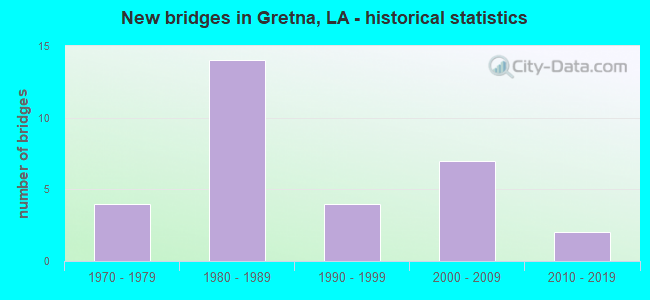
- New bridges - historical statistics
- 41970-1979
- 141980-1989
- 41990-1999
- 72000-2009
- 22010-2019
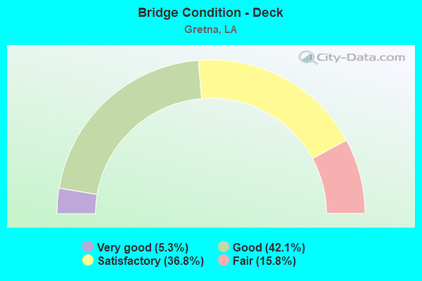
- Bridge Condition - Deck
- 5.3%Very good
- 42.1%Good
- 36.8%Satisfactory
- 15.8%Fair
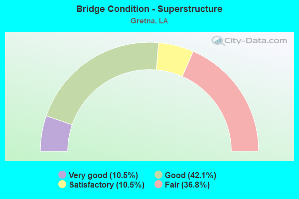
- Bridge Condition - Superstructure
- 10.5%Very good
- 42.1%Good
- 10.5%Satisfactory
- 36.8%Fair
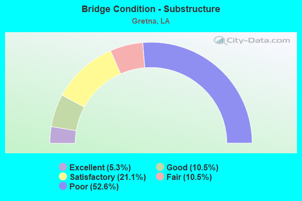
- Bridge Condition - Substructure
- 5.3%Excellent
- 10.5%Good
- 21.1%Satisfactory
- 10.5%Fair
- 52.6%Poor
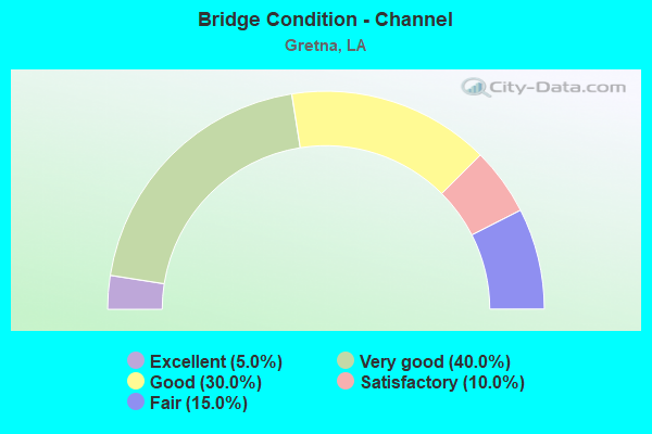
- Bridge Condition - Channel
- 5.0%Excellent
- 40.0%Very good
- 30.0%Good
- 10.0%Satisfactory
- 15.0%Fair
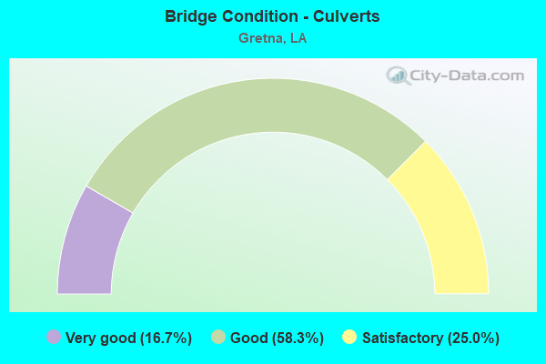
- Bridge Condition - Culverts
- 16.7%Very good
- 58.3%Good
- 25.0%Satisfactory
Find on map >> Show street view
Structure Number: 22600000000041, Location: 0.2 MI N OF LA 23 (Lat: 29.902311, Lng: -90.045731), Route carried "on" structure: County highway , Year Built: 2004, Status: Open, Structure Length: 1.13m (3.71ft), Average Daily Traffic: 2,500 (year 2016), Average Future Daily Traffic: 2,750 (year 2036), Design Load: HL 93, Features Intersected: DRAINAGE CANAL, Facility Carried by Structure: GRETNA BLVD
Minimum Vertical Clearance: 30+ m (98+ ft), Kilometerpoint: 0.000, Lanes on structure: 4, Owner: County Highway Agency, Approaching Roadway Width: 5.7m (18.7ft), Skew: 33 degrees, Material/Design: Concrete, Design/Construction: Culvert, Number Of Spans In Main Unit: 1, Length of Maximum Span: 7.3m (24.0ft), Curb-To-Curb Width: 5.7m (18.7ft), Out-to-Out Width: 39.0m (128.0ft)
Condition: Channel: Very good, Culverts: Satisfactory, Operating Rating: 39.5 metric tons, Method Used To Determine Operating Rating: Load and Resistance Factor Rating (LRFR) rating reported by rating factor(RF) method using HL-93 loadings, Inventory Rating: 30.5 metric tons, Method Used To Determine Inventory Rating: Load and Resistance Factor Rating (LRFR) rating reported by rating factor(RF) method using HL-93 loadings, Structural Evaluation: Equal to present minimum criteria, Deck Geometry: High priority of replacement, Waterway Adequacy: Equal to present desirable criteria, Approach Roadway Alignment: Equal to present desirable criteria, Designated Inspection Frequency: Every 24 months, Inspection Date: August 2021
Find on map >> Show street view
Structure Number: 22600000000042, Location: 0.3 Mi. W. of Gretna BLVD (Lat: 29.907161, Lng: -90.049689), Route carried "on" structure: County highway , Year Built: 2010, Status: Open, Structure Length: 0.73m (2.40ft), Average Daily Traffic: 976 (year 2007), Average Future Daily Traffic: 1,085 (year 2027), Design Load: HL 93, Features Intersected: Drain to Verret Canal, Facility Carried by Structure: Smithway Drive
Minimum Vertical Clearance: 30+ m (98+ ft), Kilometerpoint: 0.000, Lanes on structure: 2, Owner: County Highway Agency, Approaching Roadway Width: 7.4m (24.3ft), Material/Design: Concrete, Design/Construction: Culvert, Number Of Spans In Main Unit: 1, Length of Maximum Span: 7.3m (24.0ft), Curb-To-Curb Width: 7.4m (24.3ft), Out-to-Out Width: 14.6m (47.9ft)
Condition: Channel: Excellent, Culverts: Good, Operating Rating: 34.0 metric tons, Method Used To Determine Operating Rating: Load and Resistance Factor Rating (LRFR) rating reported by rating factor(RF) method using HL-93 loadings, Inventory Rating: 26.2 metric tons, Method Used To Determine Inventory Rating: Load and Resistance Factor Rating (LRFR) rating reported by rating factor(RF) method using HL-93 loadings, Structural Evaluation: Equal to present minimum criteria, Deck Geometry: Meets minimum limits, Waterway Adequacy: Superior to present desirable criteria, Approach Roadway Alignment: Equal to present minimum criteria, Designated Inspection Frequency: Every 24 months, Inspection Date: August 2021
Find on map >> Show street view
Structure Number: 22600000000043, Location: 0.1 MI N OF LA 23 (Lat: 29.899869, Lng: -90.043881), Route carried "on" structure: County highway , Year Built: 2004, Status: Open, Structure Length: 0.61m (2.00ft), Average Daily Traffic: 2,500 (year 2016), Average Future Daily Traffic: 2,750 (year 2036), Design Load: HL 93, Features Intersected: DRAINAGE CANAL, Facility Carried by Structure: WHITNEY AVE
Minimum Vertical Clearance: 30+ m (98+ ft), Kilometerpoint: 0.000, Lanes on structure: 2, Owner: County Highway Agency, Approaching Roadway Width: 8.0m (26.2ft), Skew: 3 degrees, Material/Design: Concrete, Design/Construction: Culvert, Number Of Spans In Main Unit: 2, Length of Maximum Span: 3.0m (9.8ft), Curb-To-Curb Width: 8.2m (26.9ft), Out-to-Out Width: 26.2m (86.0ft)
Condition: Channel: Very good, Culverts: Satisfactory, Operating Rating: 30.1 metric tons, Method Used To Determine Operating Rating: Load and Resistance Factor Rating (LRFR) rating reported by rating factor(RF) method using HL-93 loadings, Inventory Rating: 23.3 metric tons, Method Used To Determine Inventory Rating: Load and Resistance Factor Rating (LRFR) rating reported by rating factor(RF) method using HL-93 loadings, Structural Evaluation: Equal to present minimum criteria, Deck Geometry: High priority of corrective action, Waterway Adequacy: Equal to present desirable criteria, Approach Roadway Alignment: Equal to present desirable criteria, Designated Inspection Frequency: Every 24 months, Inspection Date: August 2021
Find on map >> Show street view
Structure Number: 22600000000044, Location: Carol Sue @ Whitney AVE (Lat: 29.900100, Lng: -90.043711), Route carried "on" structure: County highway , Year Built: 2004, Status: Open, Structure Length: 0.61m (2.00ft), Average Daily Traffic: 250 (year 2016), Average Future Daily Traffic: 275 (year 2036), Design Load: HL 93, Features Intersected: Verret Canal, Facility Carried by Structure: Carol Sue Ave
Minimum Vertical Clearance: 30+ m (98+ ft), Kilometerpoint: 0.000, Lanes on structure: 3, Owner: County Highway Agency, Approaching Roadway Width: 9.1m (29.9ft), Skew: 30 degrees, Material/Design: Concrete, Design/Construction: Culvert, Number Of Spans In Main Unit: 2, Length of Maximum Span: 2.9m (9.5ft), Curb-To-Curb Width: 27.4m (89.9ft), Out-to-Out Width: 118.9m (390.1ft)
Condition: Channel: Very good, Culverts: Good, Operating Rating: 30.8 metric tons, Method Used To Determine Operating Rating: Load and Resistance Factor Rating (LRFR) rating reported by rating factor(RF) method using HL-93 loadings, Inventory Rating: 24.0 metric tons, Method Used To Determine Inventory Rating: Load and Resistance Factor Rating (LRFR) rating reported by rating factor(RF) method using HL-93 loadings, Structural Evaluation: Equal to present minimum criteria, Deck Geometry: Superior to present desirable criteria, Waterway Adequacy: Superior to present desirable criteria, Approach Roadway Alignment: Equal to present minimum criteria, Designated Inspection Frequency: Every 24 months, Inspection Date: August 2021
Find on map >> Show street view
Structure Number: 22600000000045, Location: 0.35 MI N OF LA 23 (Lat: 29.903300, Lng: -90.043489), Route carried "on" structure: Ramp County highway , Year Built: 2005, Status: Open, Structure Length: 0.61m (2.00ft), Average Daily Traffic: 500 (year 2016), Average Future Daily Traffic: 600 (year 2038), Design Load: HL 93, Features Intersected: VERRETT CANAL, Facility Carried by Structure: WHITNEY AVE
Minimum Vertical Clearance: 30+ m (98+ ft), Kilometerpoint: 0.000, Lanes on structure: 1, Owner: County Highway Agency, Approaching Roadway Width: 8.0m (26.2ft), Material/Design: Concrete, Design/Construction: Culvert, Number Of Spans In Main Unit: 2, Length of Maximum Span: 3.0m (9.8ft), Curb-To-Curb Width: 13.7m (44.9ft), Out-to-Out Width: 21.3m (69.9ft)
Condition: Channel: Very good, Culverts: Very good, Operating Rating: 42.1 metric tons, Method Used To Determine Operating Rating: Load and Resistance Factor Rating (LRFR) rating reported by rating factor(RF) method using HL-93 loadings, Inventory Rating: 32.4 metric tons, Method Used To Determine Inventory Rating: Load and Resistance Factor Rating (LRFR) rating reported by rating factor(RF) method using HL-93 loadings, Structural Evaluation: Equal to present desirable criteria, Deck Geometry: Superior to present desirable criteria, Waterway Adequacy: Equal to present desirable criteria, Approach Roadway Alignment: Somewhat better than minimum adequacy, Designated Inspection Frequency: Every 24 months, Inspection Date: August 2021
Find on map >> Show street view
Structure Number: 22600000000046, Location: 0.4 MI N OF LA 23 (Lat: 29.904131, Lng: -90.043439), Route carried "on" structure: Ramp County highway , Year Built: 2005, Status: Open, Structure Length: 0.61m (2.00ft), Average Daily Traffic: 500 (year 2016), Average Future Daily Traffic: 600 (year 2038), Design Load: HL 93, Features Intersected: VERRETT CANAL, Facility Carried by Structure: WHITNEY AVE
Minimum Vertical Clearance: 30+ m (98+ ft), Kilometerpoint: 0.000, Lanes on structure: 1, Owner: County Highway Agency, Approaching Roadway Width: 7.6m (24.9ft), Material/Design: Concrete, Design/Construction: Culvert, Number Of Spans In Main Unit: 2, Length of Maximum Span: 3.0m (9.8ft), Curb-To-Curb Width: 13.9m (45.6ft), Out-to-Out Width: 21.3m (69.9ft)
Condition: Channel: Very good, Culverts: Very good, Operating Rating: 42.1 metric tons, Method Used To Determine Operating Rating: Load and Resistance Factor Rating (LRFR) rating reported by rating factor(RF) method using HL-93 loadings, Inventory Rating: 32.4 metric tons, Method Used To Determine Inventory Rating: Load and Resistance Factor Rating (LRFR) rating reported by rating factor(RF) method using HL-93 loadings, Structural Evaluation: Equal to present desirable criteria, Deck Geometry: Superior to present desirable criteria, Waterway Adequacy: Equal to present desirable criteria, Approach Roadway Alignment: Somewhat better than minimum adequacy, Designated Inspection Frequency: Every 24 months, Inspection Date: August 2021
Find on map >> Show street view
Structure Number: 22600000000047, Location: 0.9 MI N OF LA 23 (Lat: 29.910650, Lng: -90.043019), Route carried "on" structure: Ramp County highway , Year Built: 2005, Status: Open, Structure Length: 0.76m (2.49ft), Average Daily Traffic: 500 (year 2016), Average Future Daily Traffic: 600 (year 2038), Design Load: HL 93, Features Intersected: VERRETT CANAL, Facility Carried by Structure: WHITNEY AVE
Minimum Vertical Clearance: 30+ m (98+ ft), Kilometerpoint: 0.000, Lanes on structure: 1, Owner: County Highway Agency, Approaching Roadway Width: 8.0m (26.2ft), Material/Design: Concrete, Design/Construction: Culvert, Number Of Spans In Main Unit: 3, Length of Maximum Span: 2.4m (7.9ft), Curb-To-Curb Width: 8.4m (27.6ft), Out-to-Out Width: 132.3m (434.1ft)
Condition: Channel: Very good, Culverts: Good, Operating Rating: 42.1 metric tons, Method Used To Determine Operating Rating: Load and Resistance Factor Rating (LRFR) rating reported by rating factor(RF) method using HL-93 loadings, Inventory Rating: 32.4 metric tons, Method Used To Determine Inventory Rating: Load and Resistance Factor Rating (LRFR) rating reported by rating factor(RF) method using HL-93 loadings, Structural Evaluation: Better than present minimum criteria, Deck Geometry: Superior to present desirable criteria, Waterway Adequacy: Equal to present desirable criteria, Approach Roadway Alignment: Somewhat better than minimum adequacy, Designated Inspection Frequency: Every 24 months, Inspection Date: August 2021
Find on map >> Show street view
Structure Number: 22600000020519, Location: 1.0 MI. S. OF US 90B (Lat: 29.894131, Lng: -90.038400), Route carried "on" structure: State highway 23, Year Built: 1992, Status: Open, Structure Length: 0.64m (2.10ft), Average Daily Traffic: 25,000 (year 2016), Truck Traffic: 10%, Average Future Daily Traffic: 44,200 (year 2036), Design Load: HS 20, Features Intersected: WEYRAUCH CANAL
Minimum Vertical Clearance: 30+ m (98+ ft), Kilometerpoint: 2.639, Lanes on structure: 4, Base Highway Network: Yes (Inventory Route: 62-01-2, Subroute: 10), Owner: State Highway Agency, Approaching Roadway Width: 9.8m (32.2ft), Skew: 30 degrees, Material/Design: Concrete, Design/Construction: Culvert, Number Of Spans In Main Unit: 2, Length of Maximum Span: 3.0m (9.8ft)
Condition: Channel: Good, Culverts: Good, Operating Rating: 42.1 metric tons, Method Used To Determine Operating Rating: Load and Resistance Factor Rating (LRFR) rating reported by rating factor(RF) method using HL-93 loadings, Inventory Rating: 32.4 metric tons, Method Used To Determine Inventory Rating: Load and Resistance Factor Rating (LRFR) rating reported by rating factor(RF) method using HL-93 loadings, Structural Evaluation: Better than present minimum criteria, Waterway Adequacy: Better than present minimum criteria, Approach Roadway Alignment: Equal to present desirable criteria, Designated Inspection Frequency: Every 24 months, Inspection Date: June 2021, Deck Structure Type: Concrete Cast-file-Place
Find on map >> Show street view
Structure Number: 2260000002052, Location: 2.0 MI SOUTH OF US 90B (Lat: 29.883181, Lng: -90.023900), Route carried "on" structure: State highway 23, Year Built: 1992, Status: Open, Structure Length: 0.70m (2.30ft), Average Daily Traffic: 25,000 (year 2016), Truck Traffic: 10%, Average Future Daily Traffic: 44,200 (year 2036), Design Load: HS 20, Features Intersected: OAKWOOD CANAL
Minimum Vertical Clearance: 30+ m (98+ ft), Kilometerpoint: 5.221, Lanes on structure: 4, Base Highway Network: Yes (Inventory Route: 62-01-1, Subroute: 10), Owner: State Highway Agency, Approaching Roadway Width: 9.8m (32.2ft), Skew: 30 degrees, Material/Design: Concrete, Design/Construction: Culvert, Number Of Spans In Main Unit: 2, Length of Maximum Span: 3.0m (9.8ft)
Condition: Channel: Good, Culverts: Good, Operating Rating: 42.1 metric tons, Method Used To Determine Operating Rating: Load and Resistance Factor Rating (LRFR) rating reported by rating factor(RF) method using HL-93 loadings, Inventory Rating: 32.4 metric tons, Method Used To Determine Inventory Rating: Load and Resistance Factor Rating (LRFR) rating reported by rating factor(RF) method using HL-93 loadings, Structural Evaluation: Better than present minimum criteria, Waterway Adequacy: Better than present minimum criteria, Approach Roadway Alignment: Equal to present desirable criteria, Designated Inspection Frequency: Every 24 months, Inspection Date: June 2021, Deck Structure Type: Concrete Cast-file-Place
Find on map >> Show street view
Structure Number: 22600000020533, Location: .5 MI W OF MANHATTAN BLVD (Lat: 29.903469, Lng: -90.067461), Route carried "on" structure: Ramp US 90, Year Built: 2016, Status: Open, Structure Length: 25.91m (85.01ft), Average Daily Traffic: 6,600 (year 2016), Truck Traffic: 25%, Average Future Daily Traffic: 11,443 (year 2033), Features Intersected: Ground
Minimum Vertical Clearance: 5.64m (18.50ft), Kilometerpoint: 3.943, Lanes on structure: 1, Base Highway Network: Yes (Inventory Route: 283-09-A, Subroute: 40), Owner: State Highway Agency, Approaching Roadway Width: 4.6m (15.1ft), Material/Design: Concrete, Design/Construction: Box Beam or Girders - Multiple, Number Of Spans In Main Unit: 4, Number Of Approach Spans: 11, Length of Maximum Span: 39.6m (129.9ft), Curb-To-Curb Width: 7.3m (24.0ft), Out-to-Out Width: 8.2m (26.9ft)
Condition: Deck: Good, Superstructure: Very good, Substructure: Excellent, Operating Rating: 56.4 metric tons, Method Used To Determine Operating Rating: Load and Resistance Factor Rating (LRFR) rating reported by rating factor(RF) method using HL-93 loadings, Inventory Rating: 43.4 metric tons, Method Used To Determine Inventory Rating: Load and Resistance Factor Rating (LRFR) rating reported by rating factor(RF) method using HL-93 loadings, Structural Evaluation: Equal to present desirable criteria, Deck Geometry: Better than present minimum criteria, Approach Roadway Alignment: Equal to present desirable criteria, Designated Inspection Frequency: Every 24 months, Inspection Date: December 2020, Deck Structure Type: Concrete Cast-file-Place, Wearing Surface/Protective System: Wearing Surface: Monolithic Concrete
Find on map >> Show street view
Structure Number: 22602830900125, Location: 1.3 MI WEST OF LA 23 (Lat: 29.925431, Lng: -90.040539), Route carried "on" structure: Ramp US 90, Year Built: 1987, Status: Open, Structure Length: 19.66m (64.50ft), Average Daily Traffic: 9,660 (year 2018), Truck Traffic: 25%, Average Future Daily Traffic: 15,589 (year 2036), Design Load: HS 20, Features Intersected: ON RAMP FM SERVICE ROAD
Minimum Vertical Clearance: 30+ m (98+ ft), Kilometerpoint: 0.117, Lanes on structure: 1, Owner: State Highway Agency, Approaching Roadway Width: 6.1m (20.0ft), Material/Design: Concrete continuous, Design/Construction: Box Beam or Girders - Multiple, Number Of Spans In Main Unit: 2, Number Of Approach Spans: 9, Length of Maximum Span: 44.2m (145.0ft), Curb-To-Curb Width: 6.1m (20.0ft), Out-to-Out Width: 6.9m (22.6ft)
Condition: Deck: Satisfactory, Superstructure: Good, Substructure: Poor, Operating Rating: 62.6 metric tons, Method Used To Determine Operating Rating: Load Factor (LF), Inventory Rating: 32.7 metric tons, Method Used To Determine Inventory Rating: Load Factor (LF), Structural Evaluation: Meets minimum limits, Deck Geometry: Somewhat better than minimum adequacy, Approach Roadway Alignment: Better than present minimum criteria, Length Of Structure Improvement: 20.33m (66.70ft), Designated Inspection Frequency: Every 12 months, Inspection Date: October 2021, Bridge Improvement Cost: $1,734,000, Total Project Cost: $2,601,000 ( Estimate for 2016), Deck Structure Type: Concrete Cast-file-Place
Find on map >> Show street view
Structure Number: 22602830900198, Location: 1.2 MI WEST OF LA 23 (Lat: 29.922450, Lng: -90.041900), Route carried "on" structure: Ramp US 90, Year Built: 1987, Status: Open, Structure Length: 21.88m (71.78ft), Average Daily Traffic: 9,660 (year 2018), Truck Traffic: 25%, Average Future Daily Traffic: 15,589 (year 2036), Design Load: HS 20, Features Intersected: OFF RAMP OVER WHITNEY AV
Minimum Vertical Clearance: 30+ m (98+ ft), Kilometerpoint: 0.153, Lanes on structure: 1, Owner: State Highway Agency, Approaching Roadway Width: 6.1m (20.0ft), Material/Design: Concrete continuous, Design/Construction: Box Beam or Girders - Multiple, Number Of Spans In Main Unit: 3, Number Of Approach Spans: 7, Length of Maximum Span: 45.4m (149.0ft), Curb-To-Curb Width: 6.1m (20.0ft), Out-to-Out Width: 6.9m (22.6ft)
Condition: Deck: Satisfactory, Superstructure: Fair, Substructure: Poor, Operating Rating: 62.6 metric tons, Method Used To Determine Operating Rating: Load Factor (LF), Inventory Rating: 32.7 metric tons, Method Used To Determine Inventory Rating: Load Factor (LF), Structural Evaluation: Meets minimum limits, Deck Geometry: Somewhat better than minimum adequacy, Approach Roadway Alignment: Equal to present desirable criteria, Length Of Structure Improvement: 22.46m (73.69ft), Designated Inspection Frequency: Every 12 months, Inspection Date: November 2021, Bridge Improvement Cost: $1,916,000, Total Project Cost: $2,874,000 ( Estimate for 2016), Deck Structure Type: Concrete Cast-file-Place
Find on map >> Show street view
Structure Number: 22602830900607, Location: .8 MI WEST OF LA 23 (Lat: 29.919231, Lng: -90.044581), Route carried "on" structure: Ramp US 90, Year Built: 1987, Status: Open, Structure Length: 22.92m (75.20ft), Average Daily Traffic: 9,660 (year 2018), Truck Traffic: 25%, Average Future Daily Traffic: 11,084 (year 2036), Design Load: HS 20, Features Intersected: OFF RAMP TO STUMPF BLVD.
Minimum Vertical Clearance: 30+ m (98+ ft), Kilometerpoint: 0.169, Lanes on structure: 1, Owner: State Highway Agency, Approaching Roadway Width: 6.1m (20.0ft), Material/Design: Concrete continuous, Design/Construction: Box Beam or Girders - Multiple, Number Of Spans In Main Unit: 3, Number Of Approach Spans: 8, Length of Maximum Span: 43.9m (144.0ft), Curb-To-Curb Width: 6.1m (20.0ft), Out-to-Out Width: 6.9m (22.6ft)
Condition: Deck: Fair, Superstructure: Fair, Substructure: Poor, Operating Rating: 62.6 metric tons, Method Used To Determine Operating Rating: Load Factor (LF), Inventory Rating: 32.7 metric tons, Method Used To Determine Inventory Rating: Load Factor (LF), Structural Evaluation: Meets minimum limits, Deck Geometry: Somewhat better than minimum adequacy, Approach Roadway Alignment: Equal to present desirable criteria, Length Of Structure Improvement: 23.44m (76.90ft), Designated Inspection Frequency: Every 12 months, Inspection Date: November 2021, Bridge Improvement Cost: $1,999,000, Total Project Cost: $2,998,000 ( Estimate for 2016), Deck Structure Type: Concrete Cast-file-Place
Find on map >> Show street view
Structure Number: 22602830900686, Location: .7 MI WEST OF LA 23 (Lat: 29.916311, Lng: -90.045900), Route carried "on" structure: Ramp US 90, Year Built: 1987, Status: Open, Structure Length: 18.59m (60.99ft), Average Daily Traffic: 9,660 (year 2018), Truck Traffic: 25%, Average Future Daily Traffic: 15,589 (year 2036), Design Load: HS 20, Features Intersected: ON RAMP FM STUMPF BLVD.
Minimum Vertical Clearance: 30+ m (98+ ft), Kilometerpoint: 0.126, Lanes on structure: 1, Owner: State Highway Agency, Approaching Roadway Width: 6.1m (20.0ft), Material/Design: Concrete continuous, Design/Construction: Box Beam or Girders - Multiple, Number Of Spans In Main Unit: 3, Number Of Approach Spans: 5, Length of Maximum Span: 43.3m (142.1ft), Curb-To-Curb Width: 6.1m (20.0ft), Out-to-Out Width: 6.9m (22.6ft)
Condition: Deck: Fair, Superstructure: Fair, Substructure: Poor, Operating Rating: 60.8 metric tons, Method Used To Determine Operating Rating: Load Factor (LF), Inventory Rating: 33.6 metric tons, Method Used To Determine Inventory Rating: Load Factor (LF), Structural Evaluation: Meets minimum limits, Deck Geometry: Somewhat better than minimum adequacy, Approach Roadway Alignment: Equal to present desirable criteria, Length Of Structure Improvement: 19.32m (63.39ft), Designated Inspection Frequency: Every 12 months, Inspection Date: November 2021, Bridge Improvement Cost: $1,648,000, Total Project Cost: $2,472,000 ( Estimate for 2016), Deck Structure Type: Concrete Cast-file-Place
Find on map >> Show street view
Structure Number: 22602830900985, Location: .1 MI WEST OF LA 23 (Lat: 29.914931, Lng: -90.048169), Route carried "on" structure: Ramp US 90, Year Built: 1985, Status: Open, Structure Length: 15.36m (50.39ft), Average Daily Traffic: 9,660 (year 2018), Truck Traffic: 25%, Average Future Daily Traffic: 11,084 (year 2036), Design Load: HS 20, Features Intersected: ON RAMP ST-4
Minimum Vertical Clearance: 30+ m (98+ ft), Kilometerpoint: 0.092, Lanes on structure: 1, Owner: State Highway Agency, Approaching Roadway Width: 6.1m (20.0ft), Material/Design: Concrete continuous, Design/Construction: Box Beam or Girders - Multiple, Number Of Spans In Main Unit: 2, Number Of Approach Spans: 6, Length of Maximum Span: 40.2m (131.9ft), Curb-To-Curb Width: 6.1m (20.0ft), Out-to-Out Width: 6.9m (22.6ft)
Condition: Deck: Good, Superstructure: Good, Substructure: Poor, Operating Rating: 58.0 metric tons, Method Used To Determine Operating Rating: Load Factor (LF), Inventory Rating: 32.7 metric tons, Method Used To Determine Inventory Rating: Load Factor (LF), Structural Evaluation: Meets minimum limits, Deck Geometry: Somewhat better than minimum adequacy, Approach Roadway Alignment: Better than present minimum criteria, Length Of Structure Improvement: 16.25m (53.31ft), Designated Inspection Frequency: Every 12 months, Inspection Date: November 2021, Bridge Improvement Cost: $1,385,000, Total Project Cost: $2,077,000 ( Estimate for 2016), Deck Structure Type: Concrete Cast-file-Place
Find on map >> Show street view
Structure Number: 22602830901018, Location: .4 MI WEST OF LA 23 (Lat: 29.913261, Lng: -90.050039), Route carried "on" structure: Ramp US 90, Year Built: 1985, Status: Open, Structure Length: 17.80m (58.40ft), Average Daily Traffic: 8,940 (year 2016), Truck Traffic: 25%, Average Future Daily Traffic: 15,589 (year 2036), Design Load: HS 20, Features Intersected: OFF RAMP ST-3
Minimum Vertical Clearance: 30+ m (98+ ft), Kilometerpoint: 0.220, Lanes on structure: 1, Owner: State Highway Agency, Approaching Roadway Width: 6.1m (20.0ft), Material/Design: Concrete continuous, Design/Construction: Box Beam or Girders - Multiple, Number Of Spans In Main Unit: 2, Number Of Approach Spans: 8, Length of Maximum Span: 40.2m (131.9ft), Curb-To-Curb Width: 6.1m (20.0ft), Out-to-Out Width: 6.9m (22.6ft)
Condition: Deck: Good, Superstructure: Good, Substructure: Poor, Operating Rating: 58.0 metric tons, Method Used To Determine Operating Rating: Load Factor (LF), Inventory Rating: 32.7 metric tons, Method Used To Determine Inventory Rating: Load Factor (LF), Structural Evaluation: Meets minimum limits, Deck Geometry: Somewhat better than minimum adequacy, Approach Roadway Alignment: Equal to present desirable criteria, Length Of Structure Improvement: 18.56m (60.89ft), Designated Inspection Frequency: Every 12 months, Inspection Date: November 2021, Bridge Improvement Cost: $1,583,000, Total Project Cost: $2,374,000 ( Estimate for 2016), Deck Structure Type: Concrete Cast-file-Place
Find on map >> Show street view
Structure Number: 22602830901223, Location: .2 MI WEST OF LA 23 (Lat: 29.912269, Lng: -90.051500), Route carried "on" structure: ServiceUS 90, Year Built: 1982, Status: Open, Structure Length: 0.73m (2.40ft), Average Daily Traffic: 6,600 (year 2016), Truck Traffic: 13%, Average Future Daily Traffic: 11,084 (year 2036), Design Load: HS 20, Features Intersected: WESTBANK EXPY. EB FR RD
Minimum Vertical Clearance: 30+ m (98+ ft), Kilometerpoint: 3.009, Lanes on structure: 3, Owner: State Highway Agency, Approaching Roadway Width: 10.7m (35.1ft), Skew: 30 degrees, Material/Design: Concrete, Design/Construction: Culvert, Number Of Spans In Main Unit: 2, Length of Maximum Span: 3.4m (11.2ft), Curb-To-Curb Width: 10.6m (34.8ft), Out-to-Out Width: 45.6m (149.6ft)
Condition: Channel: Satisfactory, Culverts: Good, Operating Rating: 42.1 metric tons, Method Used To Determine Operating Rating: Load and Resistance Factor Rating (LRFR) rating reported by rating factor(RF) method using HL-93 loadings, Inventory Rating: 32.4 metric tons, Method Used To Determine Inventory Rating: Load and Resistance Factor Rating (LRFR) rating reported by rating factor(RF) method using HL-93 loadings, Structural Evaluation: Better than present minimum criteria, Deck Geometry: High priority of replacement, Waterway Adequacy: Equal to present minimum criteria, Approach Roadway Alignment: Equal to present desirable criteria, Length Of Structure Improvement: 1.34m (4.40ft), Designated Inspection Frequency: Every 24 months, Inspection Date: June 2020, Bridge Improvement Cost: $114,000, Total Project Cost: $171,000 ( Estimate for 2016), Deck Structure Type: Concrete Cast-file-Place
Find on map >> Show street view
Structure Number: 22602830901367, Location: .4 MI WEST OF LA 23 (Lat: 29.911719, Lng: -90.053531), Route carried "on" structure: Ramp US 90, Year Built: 1985, Status: Open, Structure Length: 16.89m (55.41ft), Average Daily Traffic: 7,860 (year 2018), Truck Traffic: 25%, Average Future Daily Traffic: 11,084 (year 2036), Design Load: HS 20, Features Intersected: OFF RAMP LA-1
Minimum Vertical Clearance: 30+ m (98+ ft), Kilometerpoint: 0.151, Lanes on structure: 1, Owner: State Highway Agency, Approaching Roadway Width: 6.1m (20.0ft), Material/Design: Concrete continuous, Design/Construction: Box Beam or Girders - Multiple, Number Of Spans In Main Unit: 2, Number Of Approach Spans: 7, Length of Maximum Span: 41.8m (137.1ft), Curb-To-Curb Width: 6.1m (20.0ft), Out-to-Out Width: 6.9m (22.6ft)
Condition: Deck: Satisfactory, Superstructure: Fair, Substructure: Poor, Operating Rating: 60.8 metric tons, Method Used To Determine Operating Rating: Load Factor (LF), Inventory Rating: 32.7 metric tons, Method Used To Determine Inventory Rating: Load Factor (LF), Structural Evaluation: Meets minimum limits, Deck Geometry: Somewhat better than minimum adequacy, Approach Roadway Alignment: Equal to present desirable criteria, Length Of Structure Improvement: 17.71m (58.10ft), Designated Inspection Frequency: Every 12 months, Inspection Date: November 2021, Bridge Improvement Cost: $1,510,000, Total Project Cost: $2,265,000 ( Estimate for 2016), Deck Structure Type: Concrete Cast-file-Place
Find on map >> Show street view
Structure Number: 22602830901416, Location: .01 MI EAST OF LA 23 (Lat: 29.909881, Lng: -90.055569), Route carried "on" structure: Ramp US 90, Year Built: 1985, Status: Open, Structure Length: 16.83m (55.22ft), Average Daily Traffic: 7,860 (year 2018), Truck Traffic: 25%, Average Future Daily Traffic: 11,084 (year 2036), Design Load: HS 20, Features Intersected: ON RAMP LA-2
Minimum Vertical Clearance: 30+ m (98+ ft), Kilometerpoint: 0.106, Lanes on structure: 1, Owner: State Highway Agency, Approaching Roadway Width: 6.1m (20.0ft), Material/Design: Concrete continuous, Design/Construction: Box Beam or Girders - Multiple, Number Of Spans In Main Unit: 2, Number Of Approach Spans: 7, Length of Maximum Span: 41.5m (136.2ft), Curb-To-Curb Width: 6.1m (20.0ft), Out-to-Out Width: 6.9m (22.6ft)
Condition: Deck: Satisfactory, Superstructure: Fair, Substructure: Poor, Operating Rating: 60.8 metric tons, Method Used To Determine Operating Rating: Load Factor (LF), Inventory Rating: 32.7 metric tons, Method Used To Determine Inventory Rating: Load Factor (LF), Structural Evaluation: Meets minimum limits, Deck Geometry: Somewhat better than minimum adequacy, Approach Roadway Alignment: Equal to present desirable criteria, Length Of Structure Improvement: 17.65m (57.91ft), Designated Inspection Frequency: Every 12 months, Inspection Date: November 2021, Bridge Improvement Cost: $1,505,000, Total Project Cost: $2,257,000 ( Estimate for 2016), Deck Structure Type: Concrete Cast-file-Place
Find on map >> Show street view
Structure Number: 22602830901645, Location: .2 MI EAST OF LA 23 (Lat: 29.909589, Lng: -90.057281), Route carried "on" structure: Ramp US 90, Year Built: 1985, Status: Open, Structure Length: 16.76m (54.99ft), Average Daily Traffic: 7,860 (year 2018), Truck Traffic: 25%, Average Future Daily Traffic: 11,084 (year 2036), Design Load: HS 20, Features Intersected: RAMP LA-4
Minimum Vertical Clearance: 30+ m (98+ ft), Kilometerpoint: 0.068, Lanes on structure: 1, Owner: State Highway Agency, Approaching Roadway Width: 6.1m (20.0ft), Material/Design: Concrete continuous, Design/Construction: Box Beam or Girders - Multiple, Number Of Spans In Main Unit: 2, Number Of Approach Spans: 7, Length of Maximum Span: 41.1m (134.8ft), Curb-To-Curb Width: 6.1m (20.0ft), Out-to-Out Width: 6.9m (22.6ft)
Condition: Deck: Fair, Superstructure: Fair, Substructure: Fair, Operating Rating: 66.2 metric tons, Method Used To Determine Operating Rating: Load Factor (LF), Inventory Rating: 39.0 metric tons, Method Used To Determine Inventory Rating: Load Factor (LF), Structural Evaluation: Somewhat better than minimum adequacy, Deck Geometry: Somewhat better than minimum adequacy, Approach Roadway Alignment: Equal to present desirable criteria, Length Of Structure Improvement: 17.59m (57.71ft), Designated Inspection Frequency: Every 24 months, Inspection Date: November 2021, Bridge Improvement Cost: $1,500,000, Total Project Cost: $2,250,000 ( Estimate for 2016), Deck Structure Type: Concrete Cast-file-Place
Find on map >> Show street view
Structure Number: 22602830901728, Location: .3 MI EAST OF LA 23 (Lat: 29.907519, Lng: -90.059611), Route carried "on" structure: Ramp US 90, Year Built: 1985, Status: Open, Structure Length: 15.73m (51.61ft), Average Daily Traffic: 7,860 (year 2018), Truck Traffic: 25%, Average Future Daily Traffic: 11,084 (year 2036), Design Load: HS 20, Features Intersected: RAMP LA-3
Minimum Vertical Clearance: 30+ m (98+ ft), Kilometerpoint: 0.227, Lanes on structure: 1, Owner: State Highway Agency, Approaching Roadway Width: 6.1m (20.0ft), Material/Design: Prestressed concrete continuous, Design/Construction: Box Beam or Girders - Multiple, Number Of Spans In Main Unit: 2, Number Of Approach Spans: 6, Length of Maximum Span: 42.1m (138.1ft), Curb-To-Curb Width: 6.1m (20.0ft), Out-to-Out Width: 6.9m (22.6ft)
Condition: Deck: Satisfactory, Superstructure: Fair, Substructure: Poor, Operating Rating: 60.8 metric tons, Method Used To Determine Operating Rating: Load Factor (LF), Inventory Rating: 32.7 metric tons, Method Used To Determine Inventory Rating: Load Factor (LF), Structural Evaluation: Meets minimum limits, Deck Geometry: Somewhat better than minimum adequacy, Approach Roadway Alignment: Equal to present desirable criteria, Length Of Structure Improvement: 16.61m (54.49ft), Designated Inspection Frequency: Every 12 months, Inspection Date: November 2021, Bridge Improvement Cost: $1,417,000, Total Project Cost: $2,125,000 ( Estimate for 2016), Deck Structure Type: Concrete Cast-file-Place
Find on map >> Show street view
Structure Number: 22629518900221, Location: .80 MI.S. OF LAPALCO BLVD (Lat: 29.868711, Lng: -90.031411), Route carried "on" structure: County highway , Year Built: 1980, Status: Open, Structure Length: 4.05m (13.29ft), Average Daily Traffic: 8,000 (year 1988), Average Future Daily Traffic: 13,600 (year 2036), Design Load: HS 20, Features Intersected: BAYOU FATMA, Facility Carried by Structure: WALL BLVD
Minimum Vertical Clearance: 30+ m (98+ ft), Kilometerpoint: 0.000, Lanes on structure: 2, Owner: County Highway Agency, Approaching Roadway Width: 8.5m (27.9ft), Material/Design: Concrete, Design/Construction: Slab, Number Of Spans In Main Unit: 7, Length of Maximum Span: 5.8m (19.0ft), Curb or Sidewalk Widths: Left: 0.0m, Right: 1.2m (3.9ft), Curb-To-Curb Width: 8.5m (27.9ft), Out-to-Out Width: 10.7m (35.1ft)
Condition: Deck: Satisfactory, Superstructure: Satisfactory, Substructure: Poor, Channel: Good, Operating Rating: 38.2 metric tons, Method Used To Determine Operating Rating: Load and Resistance Factor Rating (LRFR) rating reported by rating factor(RF) method using HL-93 loadings, Inventory Rating: 29.5 metric tons, Method Used To Determine Inventory Rating: Load and Resistance Factor Rating (LRFR) rating reported by rating factor(RF) method using HL-93 loadings, Structural Evaluation: Meets minimum limits, Deck Geometry: High priority of corrective action, Waterway Adequacy: Better than present minimum criteria, Approach Roadway Alignment: Better than present minimum criteria, Length Of Structure Improvement: 4.97m (16.31ft), Designated Inspection Frequency: Every 24 months, Underwater Inspection Frequency: Every 60 months, Other Special Inspection Frequency: Every 12 months, Inspection Date: Febuary 2021, Underwater Inspection Date: March 2019, Other Special Inspection Date: Febuary 2020, Bridge Improvement Cost: $296,000, Total Project Cost: $444,000 ( Estimate for 2016), Deck Structure Type: Concrete Precast Panels, Wearing Surface/Protective System: Wearing Surface: Monolithic Concrete
Find on map >> Show street view
Structure Number: 22629518900222, Location: .80 MI S. OF LAPALCO BLVD (Lat: 29.868981, Lng: -90.031761), Route carried "on" structure: County highway , Year Built: 1988, Status: Open, Structure Length: 4.05m (13.29ft), Average Daily Traffic: 8,000 (year 1988), Average Future Daily Traffic: 13,600 (year 2036), Design Load: HS 20, Features Intersected: BAYOU FATMA, Facility Carried by Structure: WALL BLVD
Minimum Vertical Clearance: 30+ m (98+ ft), Kilometerpoint: 0.000, Lanes on structure: 2, Owner: County Highway Agency, Approaching Roadway Width: 9.1m (29.9ft), Skew: 10 degrees, Material/Design: Concrete, Design/Construction: Slab, Number Of Spans In Main Unit: 7, Length of Maximum Span: 5.8m (19.0ft), Curb or Sidewalk Widths: Left: 1.2m (3.9ft), Right: 0.0m, Curb-To-Curb Width: 9.2m (30.2ft), Out-to-Out Width: 11.2m (36.7ft)
Condition: Deck: Good, Superstructure: Good, Substructure: Satisfactory, Channel: Good, Operating Rating: 57.7 metric tons, Method Used To Determine Operating Rating: Load and Resistance Factor Rating (LRFR) rating reported by rating factor(RF) method using HL-93 loadings, Inventory Rating: 44.4 metric tons, Method Used To Determine Inventory Rating: Load and Resistance Factor Rating (LRFR) rating reported by rating factor(RF) method using HL-93 loadings, Structural Evaluation: Equal to present minimum criteria, Deck Geometry: Meets minimum limits, Waterway Adequacy: Better than present minimum criteria, Approach Roadway Alignment: Better than present minimum criteria, Designated Inspection Frequency: Every 24 months, Underwater Inspection Frequency: Every 60 months, Inspection Date: Febuary 2021, Underwater Inspection Date: March 2019, Deck Structure Type: Concrete Precast Panels, Wearing Surface/Protective System: Wearing Surface: Monolithic Concrete
Find on map >> Show street view
Structure Number: 22629520900241, Location: 0.8 MI W OF LAPALCO BLVD. (Lat: 29.867681, Lng: -90.040139), Route carried "on" structure: County highway , Year Built: 2002, Status: Open, Structure Length: 2.29m (7.51ft), Design Load: HS 20, Features Intersected: WEYRAUCH CANAL, Facility Carried by Structure: FAIRFIELD AVE
Minimum Vertical Clearance: 30+ m (98+ ft), Kilometerpoint: 0.000, Lanes on structure: 2, Owner: City or Municipal Highway Agency, Approaching Roadway Width: 7.3m (24.0ft), Skew: 4 degrees, Material/Design: Concrete, Design/Construction: Slab, Number Of Spans In Main Unit: 4, Length of Maximum Span: 4.9m (16.1ft), Curb or Sidewalk Widths: Left: 1.2m (3.9ft), Right: 1.2m (3.9ft), Curb-To-Curb Width: 9.6m (31.5ft), Out-to-Out Width: 13.4m (44.0ft)
Condition: Deck: Good, Superstructure: Good, Substructure: Satisfactory, Channel: Satisfactory, Operating Rating: 38.9 metric tons, Method Used To Determine Operating Rating: Load and Resistance Factor Rating (LRFR) rating reported by rating factor(RF) method using HL-93 loadings, Inventory Rating: 30.1 metric tons, Method Used To Determine Inventory Rating: Load and Resistance Factor Rating (LRFR) rating reported by rating factor(RF) method using HL-93 loadings, Structural Evaluation: Equal to present minimum criteria, Deck Geometry: Better than present minimum criteria, Waterway Adequacy: Equal to present desirable criteria, Approach Roadway Alignment: Equal to present minimum criteria, Designated Inspection Frequency: Every 24 months, Inspection Date: Febuary 2021, Deck Structure Type: Concrete Cast-file-Place
Find on map >> Show street view
Structure Number: 22629526900261, Location: 0.3MI.E.OF MANHATTAN (Lat: 29.876450, Lng: -90.043611), Route carried "on" structure: County highway , Year Built: 1976, Status: Open, Structure Length: 4.63m (15.19ft), Average Daily Traffic: 30,000 (year 1979), Average Future Daily Traffic: 51,000 (year 2036), Design Load: HS 20, Features Intersected: VERRET CANAL, Facility Carried by Structure: LAPALCO BLVD
Minimum Vertical Clearance: 30+ m (98+ ft), Kilometerpoint: 0.000, Lanes on structure: 3, Owner: County Highway Agency, Approaching Roadway Width: 12.5m (41.0ft), Skew: 10 degrees, Material/Design: Concrete, Design/Construction: Slab, Number Of Spans In Main Unit: 8, Length of Maximum Span: 5.8m (19.0ft), Curb or Sidewalk Widths: Left: 0.0m, Right: 0.9m (3.0ft), Curb-To-Curb Width: 12.2m (40.0ft), Out-to-Out Width: 14.3m (46.9ft)
Condition: Deck: Very good, Superstructure: Very good, Substructure: Satisfactory, Channel: Fair, Operating Rating: 32.1 metric tons, Method Used To Determine Operating Rating: Load and Resistance Factor Rating (LRFR) rating reported by rating factor(RF) method using HL-93 loadings, Inventory Rating: 24.9 metric tons, Method Used To Determine Inventory Rating: Load and Resistance Factor Rating (LRFR) rating reported by rating factor(RF) method using HL-93 loadings, Structural Evaluation: Equal to present minimum criteria, Deck Geometry: Meets minimum limits, Waterway Adequacy: Better than present minimum criteria, Approach Roadway Alignment: Equal to present minimum criteria, Designated Inspection Frequency: Every 24 months, Underwater Inspection Frequency: Every 60 months, Inspection Date: January 2021, Underwater Inspection Date: March 2019, Deck Structure Type: Concrete Precast Panels, Wearing Surface/Protective System: Wearing Surface: Bituminous
Find on map >> Show street view
Structure Number: 22629526900262, Location: 0.3MI.E.OF MANHATTAN (Lat: 29.876861, Lng: -90.043169), Route carried "on" structure: City street , Year Built: 1976, Status: Open, Structure Length: 4.63m (15.19ft), Average Daily Traffic: 30,000 (year 1979), Average Future Daily Traffic: 51,000 (year 2036), Design Load: HS 20, Features Intersected: VERRET CANAL, Facility Carried by Structure: LAPALCO BLVD
Minimum Vertical Clearance: 30+ m (98+ ft), Kilometerpoint: 0.000, Lanes on structure: 3, Owner: County Highway Agency, Approaching Roadway Width: 12.5m (41.0ft), Skew: 10 degrees, Material/Design: Concrete, Design/Construction: Slab, Number Of Spans In Main Unit: 8, Length of Maximum Span: 5.8m (19.0ft), Curb or Sidewalk Widths: Left: 0.9m (3.0ft), Right: 0.0m, Curb-To-Curb Width: 12.2m (40.0ft), Out-to-Out Width: 14.2m (46.6ft)
Condition: Deck: Satisfactory, Superstructure: Satisfactory, Substructure: Good, Channel: Fair, Operating Rating: 34.7 metric tons, Method Used To Determine Operating Rating: Load and Resistance Factor Rating (LRFR) rating reported by rating factor(RF) method using HL-93 loadings, Inventory Rating: 26.6 metric tons, Method Used To Determine Inventory Rating: Load and Resistance Factor Rating (LRFR) rating reported by rating factor(RF) method using HL-93 loadings, Structural Evaluation: Equal to present minimum criteria, Deck Geometry: Meets minimum limits, Waterway Adequacy: Better than present minimum criteria, Approach Roadway Alignment: Equal to present minimum criteria, Designated Inspection Frequency: Every 24 months, Underwater Inspection Frequency: Every 60 months, Inspection Date: January 2021, Underwater Inspection Date: March 2019, Deck Structure Type: Concrete Precast Panels, Wearing Surface/Protective System: Wearing Surface: Bituminous
Find on map >> Show street view
Structure Number: 22629529900141, Location: 0.1 MI W. OF LA 23 (Lat: 29.881181, Lng: -90.024031), Route carried "on" structure: County highway , Year Built: 1977, Status: Open, Structure Length: 0.70m (2.30ft), Design Load: HS 20, Features Intersected: OAKWOOD CANAL, Facility Carried by Structure: LAPALCO BLVD
Minimum Vertical Clearance: 30+ m (98+ ft), Kilometerpoint: 0.000, Lanes on structure: 2, Owner: County Highway Agency, Approaching Roadway Width: 12.2m (40.0ft), Material/Design: Concrete, Design/Construction: Culvert, Number Of Spans In Main Unit: 2, Length of Maximum Span: 3.0m (9.8ft), Curb-To-Curb Width: 12.2m (40.0ft), Out-to-Out Width: 24.1m (79.1ft)
Condition: Channel: Good, Culverts: Good, Operating Rating: 42.1 metric tons, Method Used To Determine Operating Rating: Load and Resistance Factor Rating (LRFR) rating reported by rating factor(RF) method using HL-93 loadings, Inventory Rating: 32.4 metric tons, Method Used To Determine Inventory Rating: Load and Resistance Factor Rating (LRFR) rating reported by rating factor(RF) method using HL-93 loadings, Structural Evaluation: Better than present minimum criteria, Deck Geometry: Superior to present desirable criteria, Waterway Adequacy: Equal to present minimum criteria, Approach Roadway Alignment: Better than present minimum criteria, Designated Inspection Frequency: Every 24 months, Inspection Date: January 2021
Find on map >> Show street view
Structure Number: 22629536900321, Location: 0.5 MI. E. OF MANHATTAN (Lat: 29.893661, Lng: -90.054231), Route carried "on" structure: County highway , Year Built: 1995, Status: Open, Structure Length: 0.85m (2.79ft), Design Load: HS 20, Features Intersected: HEEBE CANAL, Facility Carried by Structure: Gretna BLVD
Minimum Vertical Clearance: 30+ m (98+ ft), Kilometerpoint: 0.000, Lanes on structure: 4, Owner: County Highway Agency, Approaching Roadway Width: 7.9m (25.9ft), Skew: 30 degrees, Material/Design: Concrete, Design/Construction: Culvert, Number Of Spans In Main Unit: 3, Length of Maximum Span: 2.7m (8.9ft), Curb-To-Curb Width: 14.9m (48.9ft), Out-to-Out Width: 36.6m (120.1ft)
Condition: Channel: Very good, Culverts: Satisfactory, Operating Rating: 42.1 metric tons, Method Used To Determine Operating Rating: Load and Resistance Factor Rating (LRFR) rating reported by rating factor(RF) method using HL-93 loadings, Inventory Rating: 32.4 metric tons, Method Used To Determine Inventory Rating: Load and Resistance Factor Rating (LRFR) rating reported by rating factor(RF) method using HL-93 loadings, Structural Evaluation: Equal to present minimum criteria, Deck Geometry: High priority of replacement, Waterway Adequacy: Equal to present desirable criteria, Approach Roadway Alignment: Equal to present desirable criteria, Length Of Structure Improvement: 1.46m (4.79ft), Designated Inspection Frequency: Every 24 months, Inspection Date: January 2021, Bridge Improvement Cost: $152,000, Total Project Cost: $228,000 ( Estimate for 2016), Deck Structure Type: Concrete Cast-file-Place
Find on map >> Show street view
Structure Number: 22629536900821, Location: 0.2 M S OF BEHRMAN HWY (Lat: 29.898811, Lng: -90.014731), Route carried "on" structure: County highway , Year Built: 1980, Status: Posted for load, Structure Length: 4.63m (15.19ft), Average Daily Traffic: 1,000 (year 1988), Average Future Daily Traffic: 1,700 (year 2036), Design Load: HS 20, Features Intersected: OUTFALL CANAL, Facility Carried by Structure: CAROL SUE AVE
Minimum Vertical Clearance: 30+ m (98+ ft), Kilometerpoint: 0.000, Lanes on structure: 2, Owner: County Highway Agency, Approaching Roadway Width: 8.5m (27.9ft), Material/Design: Concrete, Design/Construction: Slab, Number Of Spans In Main Unit: 8, Length of Maximum Span: 5.8m (19.0ft), Curb-To-Curb Width: 8.5m (27.9ft), Out-to-Out Width: 11.9m (39.0ft)
Condition: Deck: Good, Superstructure: Good, Substructure: Fair, Channel: Fair, Operating Rating: 36.3 metric tons, Method Used To Determine Operating Rating: Allowable Stress (AS), Inventory Rating: 20.9 metric tons, Method Used To Determine Inventory Rating: Allowable Stress (AS), Structural Evaluation: Somewhat better than minimum adequacy, Deck Geometry: Somewhat better than minimum adequacy, Waterway Adequacy: Equal to present desirable criteria, Approach Roadway Alignment: Better than present minimum criteria, Bridge Posting: Required (Relationship of Operating Rating to Maximum Legal Load: 0.1 - 9.9% below), Designated Inspection Frequency: Every 24 months, Underwater Inspection Frequency: Every 60 months, Inspection Date: Febuary 2021, Underwater Inspection Date: Febuary 2019, Deck Structure Type: Concrete Precast Panels
Find on map >> Show street view
Structure Number: 22629538900821, Location: 0.2 E. OF BEHRMAN HWY. (Lat: 29.894289, Lng: -90.015019), Route carried "on" structure: County highway , Year Built: 1970, Status: Posted for load, Structure Length: 4.63m (15.19ft), Average Daily Traffic: 5,000 (year 1989), Average Future Daily Traffic: 8,500 (year 2036), Design Load: HS 20, Features Intersected: OUTFALL CANAL, Facility Carried by Structure: PARK PLACE DR
Minimum Vertical Clearance: 30+ m (98+ ft), Kilometerpoint: 0.000, Lanes on structure: 2, Owner: County Highway Agency, Approaching Roadway Width: 9.8m (32.2ft), Material/Design: Concrete, Design/Construction: Slab, Number Of Spans In Main Unit: 8, Length of Maximum Span: 5.8m (19.0ft), Curb or Sidewalk Widths: Left: 0.0m, Right: 1.2m (3.9ft), Curb-To-Curb Width: 9.9m (32.5ft), Out-to-Out Width: 11.9m (39.0ft)
Condition: Deck: Good, Superstructure: Good, Substructure: Satisfactory, Channel: Good, Operating Rating: 34.5 metric tons, Method Used To Determine Operating Rating: Allowable Stress (AS), Inventory Rating: 20.9 metric tons, Method Used To Determine Inventory Rating: Allowable Stress (AS), Structural Evaluation: Somewhat better than minimum adequacy, Deck Geometry: Meets minimum limits, Waterway Adequacy: Better than present minimum criteria, Approach Roadway Alignment: Equal to present minimum criteria, Bridge Posting: Required (Relationship of Operating Rating to Maximum Legal Load: 10.0 - 19.9% below), Designated Inspection Frequency: Every 24 months, Underwater Inspection Frequency: Every 60 months, Inspection Date: Febuary 2021, Underwater Inspection Date: March 2019, Deck Structure Type: Concrete Precast Panels, Wearing Surface/Protective System: Wearing Surface: Monolithic Concrete
Find on map >> Show street view
Structure Number: 22629545900151, Location: 0.7M SOUTH OF LA 23 (Lat: 29.874139, Lng: -90.024669), Route carried "on" structure: County highway , Year Built: 1992, Status: Open, Structure Length: 1.74m (5.71ft), Average Daily Traffic: 1,000 (year 1989), Average Future Daily Traffic: 1,700 (year 2036), Design Load: HS 20, Features Intersected: OAKWOOD CANAL, Facility Carried by Structure: MT. LAUREL DR
Minimum Vertical Clearance: 30+ m (98+ ft), Kilometerpoint: 0.000, Lanes on structure: 2, Owner: County Highway Agency, Approaching Roadway Width: 11.0m (36.1ft), Material/Design: Concrete, Design/Construction: Slab, Number Of Spans In Main Unit: 3, Length of Maximum Span: 5.8m (19.0ft), Curb or Sidewalk Widths: Left: 0.0m, Right: 1.2m (3.9ft), Curb-To-Curb Width: 11.0m (36.1ft), Out-to-Out Width: 11.6m (38.1ft)
Condition: Deck: Good, Superstructure: Good, Substructure: Good, Channel: Very good, Operating Rating: 44.4 metric tons, Method Used To Determine Operating Rating: Load and Resistance Factor Rating (LRFR) rating reported by rating factor(RF) method using HL-93 loadings, Inventory Rating: 34.3 metric tons, Method Used To Determine Inventory Rating: Load and Resistance Factor Rating (LRFR) rating reported by rating factor(RF) method using HL-93 loadings, Structural Evaluation: Better than present minimum criteria, Deck Geometry: Better than present minimum criteria, Waterway Adequacy: Equal to present minimum criteria, Approach Roadway Alignment: Equal to present desirable criteria, Designated Inspection Frequency: Every 24 months, Inspection Date: January 2021, Deck Structure Type: Concrete Cast-file-Place
Find on map >> Show street view
Structure Number: 22602830900001, Location: 0.2 MI E OF LA 18 (Lat: 29.911789, Lng: -90.053339), Route carried "under" structure: ServiceUS 90, Structure Length: 0. m, Average Daily Traffic: 6,600 (year 2015), Features Intersected: US 90B WB SERVICE RD EXI
Minimum Vertical Clearance: 6.80m (22.31ft), Kilometerpoint: 0.087, Lanes on structure: 1, Length of Maximum Span: 0.0m
Find on map >> Show street view
Structure Number: 22602830900001, Location: 0.2 MI E OF LA 18 (Lat: 29.911489, Lng: -90.053539), Route carried "under" structure: ServiceUS 90, Structure Length: 0. m, Average Daily Traffic: 6,600 (year 2015), Features Intersected: US 90B EB SERVICE RD EXI
Minimum Vertical Clearance: 6.83m (22.41ft), Kilometerpoint: 0.064, Lanes on structure: 1, Length of Maximum Span: 0.0m
Find on map >> Show street view
Structure Number: 22602830900001, Location: LA 18@US 90B WB (Lat: 29.909839, Lng: -90.056581), Route carried "under" structure: State highway 18, Structure Length: 0. m, Average Daily Traffic: 9,500 (year 2014), Features Intersected: LA 18 SB UNDER US 90B WB
Minimum Vertical Clearance: 6.52m (21.39ft), Kilometerpoint: 0.872, Lanes on structure: 3, Lanes under structure: 2, Length of Maximum Span: 0.0m
Find on map >> Show street view
Structure Number: 22602830900001, Location: 0.2 MI W OF LA 18 (Lat: 29.907981, Lng: -90.059739), Route carried "under" structure: ServiceUS 90, Structure Length: 0. m, Average Daily Traffic: 6,600 (year 2015), Features Intersected: US 90B WB SERVICE RD EXI
Minimum Vertical Clearance: 7.10m (23.29ft), Kilometerpoint: 0.093, Lanes on structure: 3, Lanes under structure: 1, Length of Maximum Span: 0.0m
Find on map >> Show street view
Structure Number: 22602830900001, Location: 0.5 MI NE OF LA 23(STUMPF (Lat: 29.921319, Lng: -90.042961), Route carried "under" structure: ServiceUS 90, Structure Length: 0. m, Average Daily Traffic: 8,940 (year 2015), Features Intersected: US 90B EB EXIT TO US 90B
Minimum Vertical Clearance: 7.56m (24.80ft), Kilometerpoint: 0.050, Lanes on structure: 1, Length of Maximum Span: 0.0m
Find on map >> Show street view
Structure Number: 22602830900001, Location: 0.3 MI NE OF LA23 (STUMPF (Lat: 29.919411, Lng: -90.044200), Route carried "under" structure: ServiceUS 90, Structure Length: 0. m, Average Daily Traffic: 8,940 (year 2015), Features Intersected: US 90B EB SERVICE RD EXI
Minimum Vertical Clearance: 7.32m (24.02ft), Kilometerpoint: 0.042, Lanes on structure: 3, Lanes under structure: 1, Length of Maximum Span: 0.0m
Find on map >> Show street view
Structure Number: 22602830900001, Location: 0.01 MI NE OF LA 23(STUMP (Lat: 29.915581, Lng: -90.047200), Route carried "under" structure: ServiceUS 90, Structure Length: 0. m, Average Daily Traffic: 8,940 (year 2015), Features Intersected: US 90B WB EXIT TO US90B
Minimum Vertical Clearance: 5.88m (19.29ft), Kilometerpoint: 0.074, Lanes on structure: 1, Length of Maximum Span: 0.0m
Find on map >> Show street view
Structure Number: 22602830900001, Location: 0.5 MI S OF LA 466 (Lat: 29.915269, Lng: -90.047319), Route carried "under" structure: State highway 23, Structure Length: 0. m, Average Daily Traffic: 15,000 (year 2014), Features Intersected: LA 23 NB (STUMPF) UNDER
Minimum Vertical Clearance: 6.01m (19.72ft), Kilometerpoint: 0.040, Lanes on structure: 3, Lanes under structure: 2, Length of Maximum Span: 0.0m
Find on map >> Show street view
Structure Number: 22602830900001, Location: 0.50MI S OF LA 466 (Lat: 29.915311, Lng: -90.047539), Route carried "under" structure: State highway 23, Structure Length: 0. m, Average Daily Traffic: 15,000 (year 2014), Features Intersected: LA 23 SB (STUMPF) UNDER
Minimum Vertical Clearance: 5.91m (19.39ft), Kilometerpoint: 2.437, Lanes on structure: 2, Length of Maximum Span: 0.0m
Find on map >> Show street view
Structure Number: 22602830900001, Location: LA 18@US 90B WB (Lat: 29.909761, Lng: -90.056411), Route carried "under" structure: State highway 18, Structure Length: 0. m, Average Daily Traffic: 9,500 (year 2014), Features Intersected: LA 18 NB UNDER 90B WB
Minimum Vertical Clearance: 6.49m (21.29ft), Kilometerpoint: 5.116, Lanes on structure: 3, Lanes under structure: 2, Length of Maximum Span: 0.0m
Find on map >> Show street view
Structure Number: 22602830900002, Location: 0.01 MI NE OF LA 23 (Lat: 29.915381, Lng: -90.047069), Route carried "under" structure: ServiceUS 90, Structure Length: 0. m, Average Daily Traffic: 8,940 (year 2015), Features Intersected: US 90B WB SERVICE RD EXI
Minimum Vertical Clearance: 6.61m (21.69ft), Kilometerpoint: 0.047, Lanes on structure: 1, Length of Maximum Span: 0.0m
Find on map >> Show street view
Structure Number: 22602830900002, Location: 0.3 MI NE OF LA 23 (Lat: 29.919239, Lng: -90.043981), Route carried "under" structure: ServiceUS 90, Structure Length: 0. m, Features Intersected: US 90B EB SERVICE RD EXI
Minimum Vertical Clearance: 7.71m (25.30ft), Kilometerpoint: 0.013, Lanes on structure: 3, Lanes under structure: 1, Length of Maximum Span: 0.0m
Find on map >> Show street view
Structure Number: 22602830900002, Location: 0.5 MI NE OF LA 23 (Lat: 29.921169, Lng: -90.042731), Route carried "under" structure: ServiceUS 90, Structure Length: 0. m, Average Daily Traffic: 8,940 (year 2015), Features Intersected: US 90B EB SERVICE RD EXI
Minimum Vertical Clearance: 7.35m (24.11ft), Kilometerpoint: 0.023, Lanes on structure: 1, Length of Maximum Span: 0.0m
Find on map >> Show street view
Structure Number: 22602830900002, Location: 0.5 MI S OF LA 466 (Lat: 29.915100, Lng: -90.047169), Route carried "under" structure: State highway 23, Structure Length: 0. m, Average Daily Traffic: 15,000 (year 2014), Features Intersected: LA 23 NB UNDER US 90B EB
Minimum Vertical Clearance: 6.86m (22.51ft), Kilometerpoint: 0.016, Lanes on structure: 3, Lanes under structure: 2, Length of Maximum Span: 0.0m
Find on map >> Show street view
Structure Number: 22602830900002, Location: 0.5 MI S OF LA 466 (Lat: 29.915131, Lng: -90.047389), Route carried "under" structure: State highway 23, Structure Length: 0. m, Features Intersected: LA 23 SB UNDER US 90B EB
Minimum Vertical Clearance: 6.89m (22.60ft), Kilometerpoint: 2.461, Lanes on structure: 2, Length of Maximum Span: 0.0m
Find on map >> Show street view
Structure Number: 22602830900002, Location: 0.2 MI E OF LA 18 (Lat: 29.911561, Lng: -90.053261), Route carried "under" structure: ServiceUS 90, Structure Length: 0. m, Average Daily Traffic: 6,600 (year 2015), Features Intersected: US 90B WB SERVICE RD EXI
Minimum Vertical Clearance: 6.55m (21.49ft), Kilometerpoint: 0.061, Lanes on structure: 1, Length of Maximum Span: 0.0m
Find on map >> Show street view
Structure Number: 22602830900002, Location: 0.2 MI E OF LA 18 (Lat: 29.911311, Lng: -90.053439), Route carried "under" structure: ServiceUS 90, Structure Length: 0. m, Average Daily Traffic: 6,600 (year 2015), Features Intersected: US 90B EB SERVICE RD EXI
Minimum Vertical Clearance: 6.71m (22.01ft), Kilometerpoint: 0.042, Lanes on structure: 1, Length of Maximum Span: 0.0m
Find on map >> Show street view
Structure Number: 22602830900002, Location: LA 18 UNDER US 90B EB (Lat: 29.909569, Lng: -90.056261), Route carried "under" structure: State highway 18, Structure Length: 0. m, Average Daily Traffic: 9,500 (year 2014), Features Intersected: LA 18 NB UNDER US 90B EB
Minimum Vertical Clearance: 6.58m (21.59ft), Kilometerpoint: 5.092, Lanes on structure: 3, Lanes under structure: 2, Length of Maximum Span: 0.0m
Find on map >> Show street view
Structure Number: 22602830900002, Location: LA 18 UNDER US 90B EB (Lat: 29.909639, Lng: -90.056450), Route carried "under" structure: State highway 18, Structure Length: 0. m, Average Daily Traffic: 9,500 (year 2014), Features Intersected: LA 18 SB UNDER US 90B EB
Minimum Vertical Clearance: 6.65m (21.82ft), Kilometerpoint: 0.896, Lanes on structure: 3, Lanes under structure: 2, Length of Maximum Span: 0.0m
Find on map >> Show street view
Structure Number: 22602830900002, Location: 0.2 MI W OF LA 18 (Lat: 29.907750, Lng: -90.059611), Route carried "under" structure: ServiceUS 90, Structure Length: 0. m, Average Daily Traffic: 6,600 (year 2015), Features Intersected: US 90B WB SERVICE RD EXI
Minimum Vertical Clearance: 7.25m (23.79ft), Kilometerpoint: 0.064, Lanes on structure: 3, Lanes under structure: 1, Length of Maximum Span: 0.0m
Find on map >> Show street view
Structure Number: 22602830901018, Location: 0.4 mi W of LA 23 (Lat: 29.918869, Lng: -90.044800), Route carried "under" structure: Business US 90, Structure Length: 0. m, Average Daily Traffic: 8,940 (year 2016), Truck Traffic: 25%, Features Intersected: US 90 B crossover
Minimum Vertical Clearance: 30+ m (98+ ft), Kilometerpoint: 0.220, Lanes on structure: 1, Lanes under structure: 1, Length of Maximum Span: 0.0m
Find on map >> Show street view
Structure Number: 22602830901367, Location: 0.2 MI E OF LA 18 (Lat: 29.911600, Lng: -90.053700), Route carried "under" structure: ServiceUS 90, Structure Length: 0. m, Average Daily Traffic: 8,940 (year 2015), Features Intersected: US 90B EB SERVICE RD EXI
Minimum Vertical Clearance: 6.52m (21.39ft), Kilometerpoint: 0.085, Lanes on structure: 1, Lanes under structure: 1, Length of Maximum Span: 0.0m
Find on map >> Show street view
Structure Number: 22602830901728, Location: 0.2 MI W OF LA 18 (Lat: 29.907611, Lng: -90.059481), Route carried "under" structure: ServiceUS 90, Structure Length: 0. m, Average Daily Traffic: 6,600 (year 2015), Features Intersected: US90B WB SERVICE RD EXIT
Minimum Vertical Clearance: 6.89m (22.60ft), Kilometerpoint: 0.047, Lanes on structure: 1, Lanes under structure: 1, Length of Maximum Span: 0.0m