Bridge Statistics for Griffin, Georgia (GA)
Condition, Traffic, Stress, Structural Evaluation, Project Costs
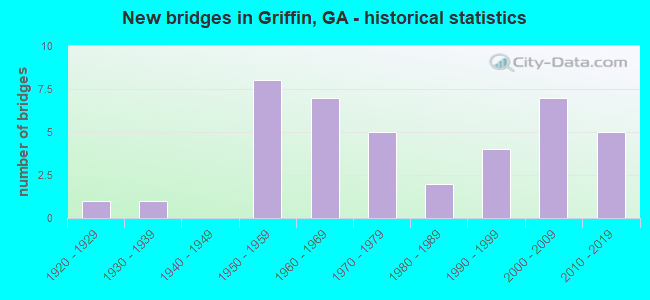
- New bridges - historical statistics
- 11920-1929
- 11930-1939
- 81950-1959
- 71960-1969
- 51970-1979
- 21980-1989
- 41990-1999
- 72000-2009
- 52010-2019
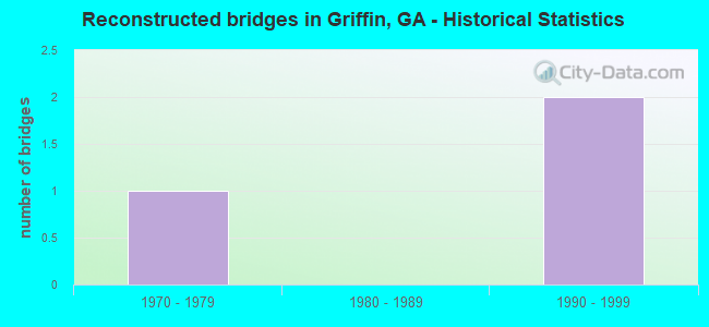
- Reconstructed bridges - Historical Statistics
- 11970-1979
- 01980-1989
- 21990-1999
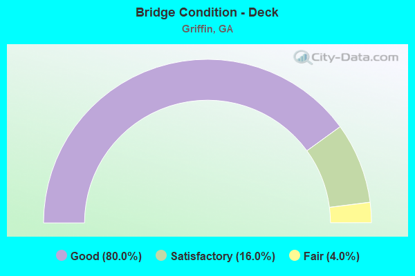
- Bridge Condition - Deck
- 80.0%Good
- 16.0%Satisfactory
- 4.0%Fair
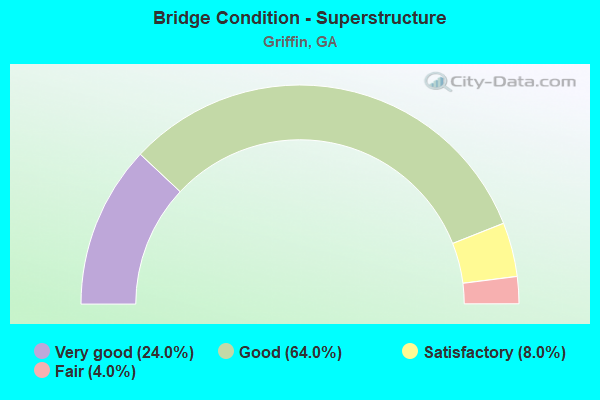
- Bridge Condition - Superstructure
- 24.0%Very good
- 64.0%Good
- 8.0%Satisfactory
- 4.0%Fair
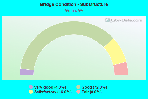
- Bridge Condition - Substructure
- 4.0%Very good
- 72.0%Good
- 16.0%Satisfactory
- 8.0%Fair
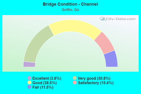
- Bridge Condition - Channel
- 3.8%Excellent
- 30.8%Very good
- 38.5%Good
- 15.4%Satisfactory
- 11.5%Fair
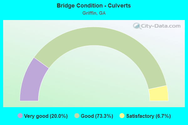
- Bridge Condition - Culverts
- 20.0%Very good
- 73.3%Good
- 6.7%Satisfactory
Find on map >> Show street view
Structure Number: 2550006, Location: IN GRIFFIN (Lat: 33.230219, Lng: -84.291869), Route carried "under" structure: State highway 362, Structure Length: 0. m, Average Daily Traffic: 9,900 (year 2010), Truck Traffic: 1%, Features Intersected: SR 3 NBL (US 19), Facility Carried by Structure: US 19, SR 3 NBL
Minimum Vertical Clearance: 5.08m (16.67ft), Kilometerpoint: 8.047, Lanes on structure: 2, Length of Maximum Span: 0.0m
Find on map >> Show street view
Structure Number: 2550007, Location: IN GRIFFIN (Lat: 33.230294, Lng: -84.291681), Route carried "under" structure: State highway 362, Structure Length: 0. m, Average Daily Traffic: 86,300 (year 1999), Truck Traffic: 1%, Features Intersected: SR 3 SBL (US 19), Facility Carried by Structure: US 19, SR 3 SBL
Minimum Vertical Clearance: 5.86m (19.23ft), Kilometerpoint: 8.047, Lanes on structure: 2, Length of Maximum Span: 0.0m
Find on map >> Show street view
Structure Number: 2550008, Location: IN GRIFFIN (Lat: 33.243008, Lng: -84.295789), Route carried "under" structure: City street 2508, Structure Length: 0. m, Average Daily Traffic: 4,000 (year 1999), Truck Traffic: 1%, Features Intersected: SR 3 NBL (US 19), Facility Carried by Structure: US 19, SR 3 NBL
Minimum Vertical Clearance: 5.18m (16.99ft), Kilometerpoint: 1.609, Lanes on structure: 2, Length of Maximum Span: 0.0m
Find on map >> Show street view
Structure Number: 2550009, Location: IN GRIFFIN (Lat: 33.242958, Lng: -84.296019), Route carried "under" structure: City street 2508, Structure Length: 0. m, Average Daily Traffic: 4,000 (year 1999), Truck Traffic: 1%, Features Intersected: SR 3 SBL (US 19), Facility Carried by Structure: US 19, SR 3 SBL
Minimum Vertical Clearance: 5.23m (17.16ft), Kilometerpoint: 1.609, Lanes on structure: 2, Length of Maximum Span: 0.0m
Find on map >> Show street view
Structure Number: 2550018, Location: IN GRIFFIN (Lat: 33.260978, Lng: -84.291150), Route carried "under" structure: US 19, Structure Length: 0. m, Average Daily Traffic: 28,700 (year 1999), Truck Traffic: 1%, Features Intersected: CR 36 ELLIS ROAD, Facility Carried by Structure: ELLIS ROAD
Minimum Vertical Clearance: 5.13m (16.83ft), Kilometerpoint: 8.047, Lanes on structure: 2, Length of Maximum Span: 0.0m
Find on map >> Show street view
Structure Number: 2550049, Location: IN GRIFFIN (Lat: 33.227556, Lng: -84.289911), Route carried "under" structure: US 19, Structure Length: 0. m, Average Daily Traffic: 16,790 (year 2011), Truck Traffic: 1%, Features Intersected: SR 3 (US 19), Facility Carried by Structure: NOR-SOU. RAILROAD
Minimum Vertical Clearance: 5.35m (17.55ft), Kilometerpoint: 4.828, Length of Maximum Span: 0.0m
Find on map >> Show street view
Structure Number: 255506, Location: IN GRIFFIN (Lat: 33.250239, Lng: -84.262108), Route carried "under" structure: City street 7, Structure Length: 0. m, Average Daily Traffic: 634 (year 2007), Truck Traffic: 1%, Features Intersected: SIXTH STREET, Facility Carried by Structure: SIXTH STREET
Minimum Vertical Clearance: 5.20m (17.06ft), Kilometerpoint: 0.000, Lanes on structure: 2, Length of Maximum Span: 0.0m
Find on map >> Show street view
Structure Number: 255506, Location: IN GRIFFIN (Lat: 33.250239, Lng: -84.262108), Route carried "under" structure: State highway 155, Structure Length: 0. m, Average Daily Traffic: 800 (year 2007), Truck Traffic: 1%, Features Intersected: SIXTH STREET, Facility Carried by Structure: SIXTH STREET
Minimum Vertical Clearance: 5.13m (16.83ft), Kilometerpoint: 6.437, Lanes on structure: 2, Length of Maximum Span: 0.0m
Find on map >> Show street view
Structure Number: 2555065, Location: IN GRIFFIN (Lat: 33.247347, Lng: -84.296419), Route carried "under" structure: US 19, Structure Length: 0. m, Average Daily Traffic: 22,600 (year 1999), Truck Traffic: 1%, Features Intersected: SR 16, Facility Carried by Structure: SR 16
Minimum Vertical Clearance: 5.46m (17.91ft), Kilometerpoint: 6.437, Lanes on structure: 6, Length of Maximum Span: 0.0m