Bridge Statistics for Hallie, Wisconsin (WI)
Condition, Traffic, Stress, Structural Evaluation, Project Costs
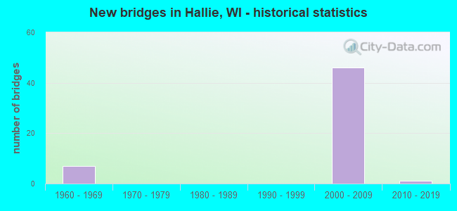
- New bridges - historical statistics
- 71960-1969
- 462000-2009
- 12010-2019


- Bridge Condition - Deck
- 64.5%Good
- 25.8%Satisfactory
- 6.5%Fair
- 3.2%Poor

- Bridge Condition - Superstructure
- 54.8%Very good
- 29.0%Good
- 9.7%Satisfactory
- 6.5%Fair

- Bridge Condition - Substructure
- 22.6%Very good
- 61.3%Good
- 12.9%Satisfactory
- 3.2%Fair

- Bridge Condition - Channel
- 14.3%Excellent
- 71.4%Very good
- 14.3%Good

- Bridge Condition - Culverts
- 50.0%Good
- 50.0%Satisfactory
Find on map >> Show street view
Structure Number: B090032, Location: 0.7M S JCT CTH J (Lat: 44.919639, Lng: -91.346894), Route carried "on" structure: City street , Year Built: 1966, Status: Open, Structure Length: 5.71m (18.73ft), Average Daily Traffic: 340 (year 2019), Average Future Daily Traffic: 340 (year 2040), Design Load: H 20, Features Intersected: STH 29, Facility Carried by Structure: LRD 160 TH ST.
Minimum Vertical Clearance: 30+ m (98+ ft), Kilometerpoint: 0.000, Lanes on structure: 2, Lanes under structure: 4, Owner: State Highway Agency, Approaching Roadway Width: 9.8m (32.2ft), Material/Design: Prestressed concrete, Design/Construction: Stringer/Multi-beam, Number Of Spans In Main Unit: 4, Length of Maximum Span: 17.7m (58.1ft), Curb-To-Curb Width: 9.1m (29.9ft), Out-to-Out Width: 10.7m (35.1ft)
Condition: Deck: Poor, Superstructure: Satisfactory, Substructure: Satisfactory, Operating Rating: 52.3 metric tons, Method Used To Determine Operating Rating: Load Factor (LF), Inventory Rating: 22.7 metric tons, Method Used To Determine Inventory Rating: Load Factor (LF), Structural Evaluation: Equal to present minimum criteria, Deck Geometry: Equal to present minimum criteria, Underclear: Somewhat better than minimum adequacy, Approach Roadway Alignment: Equal to present desirable criteria, Length Of Structure Improvement: 6.16m (20.21ft), Designated Inspection Frequency: Every 24 months, Inspection Date: April 2021, Bridge Improvement Cost: $509,000, Roadway Improvement Cost: $50,000, Total Project Cost: $764,000 ( Estimate for 2021), Deck Structure Type: Concrete Cast-file-Place, Wearing Surface/Protective System: Wearing Surface: Monolithic Concrete
Find on map >> Show street view
Structure Number: B090041, Location: 0.5 M E SEYMOUR CRAY BLVD (Lat: 44.930000, Lng: -91.353028), Route carried "on" structure: County highway , Year Built: 1965, Status: Open, Structure Length: 1.14m (3.74ft), Average Daily Traffic: 3,498 (year 2019), Average Future Daily Traffic: 3,847 (year 2039), Design Load: HS 20, Features Intersected: LRD INSTITUTION ROAD, Facility Carried by Structure: CTH J
Minimum Vertical Clearance: 30+ m (98+ ft), Kilometerpoint: 0.000, Lanes on structure: 2, Lanes under structure: 2, Owner: City or Municipal Highway Agency, Approaching Roadway Width: 10.4m (34.1ft), Material/Design: Concrete, Design/Construction: Frame, Number Of Spans In Main Unit: 1, Length of Maximum Span: 10.4m (34.1ft), Curb-To-Curb Width: 11.3m (37.1ft), Out-to-Out Width: 12.2m (40.0ft)
Condition: Deck: Fair, Superstructure: Fair, Substructure: Fair, Operating Rating: 57.0 metric tons, Method Used To Determine Operating Rating: Load Factor (LF), Inventory Rating: 32.4 metric tons, Method Used To Determine Inventory Rating: Load Factor (LF), Structural Evaluation: Somewhat better than minimum adequacy, Deck Geometry: Somewhat better than minimum adequacy, Underclear: Meets minimum limits, Approach Roadway Alignment: Equal to present desirable criteria, Designated Inspection Frequency: Every 24 months, Inspection Date: September 2020, Deck Structure Type: Concrete Cast-file-Place, Wearing Surface/Protective System: Wearing Surface: Monolithic Concrete
Find on map >> Show street view
Structure Number: B090046, Location: 0.6M W JCT STH 124 (Lat: 44.900681, Lng: -91.425936), Route carried "on" structure: City street , Year Built: 1969, Status: Open, Structure Length: 6.72m (22.05ft), Average Daily Traffic: 400 (year 2019), Average Future Daily Traffic: 400 (year 2040), Design Load: H 20, Features Intersected: USH 53, Facility Carried by Structure: LRD 40TH AVE.
Minimum Vertical Clearance: 30+ m (98+ ft), Kilometerpoint: 0.000, Lanes on structure: 2, Lanes under structure: 4, Owner: State Highway Agency, Approaching Roadway Width: 8.5m (27.9ft), Skew: 2 degrees, Material/Design: Steel continuous, Design/Construction: Stringer/Multi-beam, Number Of Spans In Main Unit: 2, Length of Maximum Span: 32.9m (107.9ft), Curb-To-Curb Width: 10.1m (33.1ft), Out-to-Out Width: 11.0m (36.1ft)
Condition: Deck: Satisfactory, Superstructure: Satisfactory, Substructure: Satisfactory, Operating Rating: 39.2 metric tons, Method Used To Determine Operating Rating: Load Factor (LF), Inventory Rating: 22.7 metric tons, Method Used To Determine Inventory Rating: Load Factor (LF), Structural Evaluation: Equal to present minimum criteria, Deck Geometry: Better than present minimum criteria, Underclear: Equal to present minimum criteria, Approach Roadway Alignment: Equal to present minimum criteria, Designated Inspection Frequency: Every 24 months, Inspection Date: May 2021, Deck Structure Type: Concrete Cast-file-Place, Wearing Surface/Protective System: Wearing Surface: Low Slump Concrete
Find on map >> Show street view
Structure Number: B090047, Location: 2.8M W JCT STH 29 (Lat: 44.914950, Lng: -91.428264), Route carried "on" structure: City street , Year Built: 1969, Status: Open, Structure Length: 5.65m (18.54ft), Average Daily Traffic: 400 (year 2019), Average Future Daily Traffic: 400 (year 2040), Design Load: H 20, Features Intersected: USH 53, Facility Carried by Structure: LRD 50TH AVE.
Minimum Vertical Clearance: 30+ m (98+ ft), Kilometerpoint: 0.000, Lanes on structure: 2, Lanes under structure: 4, Owner: State Highway Agency, Approaching Roadway Width: 9.8m (32.2ft), Material/Design: Steel continuous, Design/Construction: Stringer/Multi-beam, Number Of Spans In Main Unit: 2, Length of Maximum Span: 27.9m (91.5ft), Curb-To-Curb Width: 10.1m (33.1ft), Out-to-Out Width: 11.0m (36.1ft)
Condition: Deck: Satisfactory, Superstructure: Satisfactory, Substructure: Satisfactory, Operating Rating: 34.3 metric tons, Method Used To Determine Operating Rating: Load Factor (LF), Inventory Rating: 19.4 metric tons, Method Used To Determine Inventory Rating: Load Factor (LF), Structural Evaluation: Somewhat better than minimum adequacy, Deck Geometry: Better than present minimum criteria, Underclear: Equal to present minimum criteria, Approach Roadway Alignment: Equal to present desirable criteria, Designated Inspection Frequency: Every 24 months, Inspection Date: May 2021, Deck Structure Type: Concrete Cast-file-Place, Wearing Surface/Protective System: Wearing Surface: Low Slump Concrete
Find on map >> Show street view
Structure Number: B09021, Location: 4.4M E XING OF CTH T (Lat: 44.898531, Lng: -91.457256), Route carried "on" structure: State highway 29, Year Built: 2002, Status: Open, Structure Length: 21.60m (70.87ft), Average Daily Traffic: 6,500 (year 2019), Truck Traffic: 14%, Average Future Daily Traffic: 11,750 (year 2040), Design Load: HS 20, Features Intersected: CHIPPEWA RIVER
Minimum Vertical Clearance: 30+ m (98+ ft), Kilometerpoint: 0.000, Lanes on structure: 2, Base Highway Network: Yes, Owner: State Highway Agency, Approaching Roadway Width: 11.9m (39.0ft), Skew: 2 degrees, Material/Design: Steel continuous, Design/Construction: Stringer/Multi-beam, Number Of Spans In Main Unit: 4, Length of Maximum Span: 60.0m (196.9ft), Curb-To-Curb Width: 12.0m (39.4ft), Out-to-Out Width: 12.8m (42.0ft)
Condition: Deck: Satisfactory, Superstructure: Good, Substructure: Good, Channel: Good, Operating Rating: 65.0 metric tons, Method Used To Determine Operating Rating: Load Factor (LF), Inventory Rating: 38.9 metric tons, Method Used To Determine Inventory Rating: Load Factor (LF), Structural Evaluation: Better than present minimum criteria, Deck Geometry: Better than present minimum criteria, Waterway Adequacy: Superior to present desirable criteria, Approach Roadway Alignment: Equal to present desirable criteria, Designated Inspection Frequency: Every 24 months, Underwater Inspection Frequency: Every 72 months, Inspection Date: April 2021, Underwater Inspection Date: October 2016, Deck Structure Type: Concrete Cast-file-Place, Wearing Surface/Protective System: Wearing Surface: Low Slump Concrete, Deck Protection: Epoxy Coated Reinforcing
Find on map >> Show street view
Structure Number: B090211, Location: AT STH 29 (Lat: 44.897950, Lng: -91.448422), Route carried "on" structure: City street , Year Built: 2004, Status: Open, Structure Length: 6.80m (22.31ft), Average Daily Traffic: 440 (year 2019), Truck Traffic: 5%, Average Future Daily Traffic: 540 (year 2040), Design Load: HS 20, Features Intersected: STH 29, Facility Carried by Structure: LRD 110TH ST (SHAF
Minimum Vertical Clearance: 30+ m (98+ ft), Kilometerpoint: 0.000, Lanes on structure: 2, Lanes under structure: 4, Owner: State Highway Agency, Approaching Roadway Width: 10.1m (33.1ft), Material/Design: Prestressed concrete continuous, Design/Construction: Stringer/Multi-beam, Number Of Spans In Main Unit: 2, Length of Maximum Span: 33.6m (110.2ft), Curb-To-Curb Width: 9.6m (31.5ft), Out-to-Out Width: 10.3m (33.8ft)
Condition: Deck: Good, Superstructure: Very good, Substructure: Good, Operating Rating: 63.7 metric tons, Method Used To Determine Operating Rating: Load Factor (LF), Inventory Rating: 32.4 metric tons, Method Used To Determine Inventory Rating: Load Factor (LF), Structural Evaluation: Better than present minimum criteria, Deck Geometry: Equal to present minimum criteria, Underclear: Somewhat better than minimum adequacy, Approach Roadway Alignment: Equal to present desirable criteria, Designated Inspection Frequency: Every 48 months, Inspection Date: April 2021, Deck Structure Type: Concrete Cast-file-Place, Wearing Surface/Protective System: Wearing Surface: Monolithic Concrete, Deck Protection: Epoxy Coated Reinforcing
Find on map >> Show street view
Structure Number: B090212, Location: AT STH 29 (Lat: 44.894528, Lng: -91.427881), Route carried "on" structure: City street , Year Built: 2004, Status: Open, Structure Length: 9.87m (32.38ft), Average Daily Traffic: 440 (year 2019), Truck Traffic: 5%, Average Future Daily Traffic: 540 (year 2040), Design Load: HS 20, Features Intersected: STH 29, Facility Carried by Structure: LRD 120TH ST (EMER
Minimum Vertical Clearance: 30+ m (98+ ft), Kilometerpoint: 0.000, Lanes on structure: 2, Lanes under structure: 5, Owner: State Highway Agency, Approaching Roadway Width: 10.1m (33.1ft), Skew: 2 degrees, Material/Design: Prestressed concrete continuous, Design/Construction: Stringer/Multi-beam, Number Of Spans In Main Unit: 3, Length of Maximum Span: 32.8m (107.6ft), Curb-To-Curb Width: 9.6m (31.5ft), Out-to-Out Width: 10.3m (33.8ft)
Condition: Deck: Good, Superstructure: Very good, Substructure: Good, Operating Rating: 67.0 metric tons, Method Used To Determine Operating Rating: Load Factor (LF), Inventory Rating: 32.4 metric tons, Method Used To Determine Inventory Rating: Load Factor (LF), Structural Evaluation: Better than present minimum criteria, Deck Geometry: Equal to present minimum criteria, Underclear: Somewhat better than minimum adequacy, Approach Roadway Alignment: Equal to present desirable criteria, Designated Inspection Frequency: Every 48 months, Inspection Date: April 2021, Deck Structure Type: Concrete Cast-file-Place, Wearing Surface/Protective System: Wearing Surface: Monolithic Concrete, Deck Protection: Epoxy Coated Reinforcing
Find on map >> Show street view
Structure Number: B090213, Location: 1.7M W XING CTH P (Lat: 44.893344, Lng: -91.421667), Route carried "on" structure: State highway , Year Built: 2004, Status: Open, Structure Length: 6.00m (19.69ft), Average Daily Traffic: 9,000 (year 2019), Average Future Daily Traffic: 21,400 (year 2040), Design Load: HS 20, Features Intersected: UP RAILROAD, Facility Carried by Structure: STH 29WB
Minimum Vertical Clearance: 30+ m (98+ ft), Kilometerpoint: 0.000, Lanes on structure: 3, Base Highway Network: Yes, Owner: State Highway Agency, Approaching Roadway Width: 15.5m (50.9ft), Skew: 1 degrees, Material/Design: Prestressed concrete, Design/Construction: Stringer/Multi-beam, Number Of Spans In Main Unit: 4, Length of Maximum Span: 14.8m (48.6ft), Curb-To-Curb Width: 15.6m (51.2ft), Out-to-Out Width: 16.3m (53.5ft)
Condition: Deck: Good, Superstructure: Very good, Substructure: Good, Operating Rating: 45.7 metric tons, Method Used To Determine Operating Rating: Load Factor (LF), Inventory Rating: 34.0 metric tons, Method Used To Determine Inventory Rating: Load Factor (LF), Structural Evaluation: Better than present minimum criteria, Deck Geometry: Equal to present minimum criteria, Underclear: Equal to present minimum criteria, Approach Roadway Alignment: Equal to present desirable criteria, Designated Inspection Frequency: Every 48 months, Inspection Date: April 2021, Deck Structure Type: Concrete Cast-file-Place, Wearing Surface/Protective System: Wearing Surface: Monolithic Concrete, Deck Protection: Epoxy Coated Reinforcing
Find on map >> Show street view
Structure Number: B090214, Location: 6.1M E JCT CTH T (Lat: 44.893244, Lng: -91.422717), Route carried "on" structure: State highway 29, Year Built: 2004, Status: Open, Structure Length: 6.00m (19.69ft), Average Daily Traffic: 9,000 (year 2019), Average Future Daily Traffic: 21,400 (year 2040), Design Load: HS 20, Features Intersected: UP RAILROAD
Minimum Vertical Clearance: 30+ m (98+ ft), Kilometerpoint: 0.000, Lanes on structure: 2, Base Highway Network: Yes, Owner: State Highway Agency, Approaching Roadway Width: 11.9m (39.0ft), Skew: 1 degrees, Material/Design: Prestressed concrete, Design/Construction: Stringer/Multi-beam, Number Of Spans In Main Unit: 4, Length of Maximum Span: 14.8m (48.6ft), Curb-To-Curb Width: 12.2m (40.0ft), Out-to-Out Width: 13.0m (42.7ft)
Condition: Deck: Good, Superstructure: Very good, Substructure: Good, Operating Rating: 57.0 metric tons, Method Used To Determine Operating Rating: Load Factor (LF), Inventory Rating: 38.9 metric tons, Method Used To Determine Inventory Rating: Load Factor (LF), Structural Evaluation: Better than present minimum criteria, Deck Geometry: Better than present minimum criteria, Underclear: Equal to present minimum criteria, Approach Roadway Alignment: Equal to present desirable criteria, Designated Inspection Frequency: Every 48 months, Inspection Date: April 2021, Deck Structure Type: Concrete Cast-file-Place, Wearing Surface/Protective System: Wearing Surface: Monolithic Concrete, Deck Protection: Epoxy Coated Reinforcing
Find on map >> Show street view
Structure Number: B090215, Location: 1.5M W XING OF CTH P (Lat: 44.892647, Lng: -91.418289), Route carried "on" structure: State highway 29, Year Built: 2004, Status: Open, Structure Length: 6.40m (21.00ft), Average Daily Traffic: 10,700 (year 2019), Average Future Daily Traffic: 11,750 (year 2040), Design Load: HS 20, Features Intersected: STH 124
Minimum Vertical Clearance: 30+ m (98+ ft), Kilometerpoint: 0.000, Lanes on structure: 3, Lanes under structure: 4, Base Highway Network: Yes, Owner: State Highway Agency, Approaching Roadway Width: 15.8m (51.8ft), Skew: 1 degrees, Material/Design: Prestressed concrete continuous, Design/Construction: Stringer/Multi-beam, Number Of Spans In Main Unit: 2, Length of Maximum Span: 31.4m (103.0ft), Curb-To-Curb Width: 15.8m (51.8ft), Out-to-Out Width: 16.6m (54.5ft)
Condition: Deck: Good, Superstructure: Very good, Substructure: Good, Operating Rating: 67.0 metric tons, Method Used To Determine Operating Rating: Load Factor (LF), Inventory Rating: 38.9 metric tons, Method Used To Determine Inventory Rating: Load Factor (LF), Structural Evaluation: Better than present minimum criteria, Deck Geometry: Better than present minimum criteria, Underclear: Superior to present desirable criteria, Approach Roadway Alignment: Equal to present desirable criteria, Designated Inspection Frequency: Every 48 months, Inspection Date: April 2021, Wearing Surface/Protective System: Wearing Surface: Monolithic Concrete, Deck Protection: Epoxy Coated Reinforcing
Find on map >> Show street view
Structure Number: B090216, Location: 4.3M E XING OF CTH T (Lat: 44.892475, Lng: -91.419331), Route carried "on" structure: State highway 29, Year Built: 2004, Status: Open, Structure Length: 6.40m (21.00ft), Average Daily Traffic: 10,700 (year 2019), Average Future Daily Traffic: 11,750 (year 2040), Design Load: HS 20, Features Intersected: STH 124
Minimum Vertical Clearance: 30+ m (98+ ft), Kilometerpoint: 0.000, Lanes on structure: 2, Lanes under structure: 4, Base Highway Network: Yes, Owner: State Highway Agency, Approaching Roadway Width: 12.2m (40.0ft), Skew: 1 degrees, Material/Design: Prestressed concrete continuous, Design/Construction: Stringer/Multi-beam, Number Of Spans In Main Unit: 2, Length of Maximum Span: 31.4m (103.0ft), Curb-To-Curb Width: 12.2m (40.0ft), Out-to-Out Width: 13.0m (42.7ft)
Condition: Deck: Good, Superstructure: Good, Substructure: Good, Operating Rating: 68.6 metric tons, Method Used To Determine Operating Rating: Load Factor (LF), Inventory Rating: 35.6 metric tons, Method Used To Determine Inventory Rating: Load Factor (LF), Structural Evaluation: Better than present minimum criteria, Deck Geometry: Somewhat better than minimum adequacy, Underclear: Superior to present desirable criteria, Approach Roadway Alignment: Equal to present desirable criteria, Designated Inspection Frequency: Every 48 months, Inspection Date: April 2021, Deck Structure Type: Concrete Cast-file-Place, Wearing Surface/Protective System: Wearing Surface: Monolithic Concrete, Deck Protection: Epoxy Coated Reinforcing
Find on map >> Show street view
Structure Number: B090217, Location: AT USH 53 (Lat: 44.891831, Lng: -91.413950), Route carried "on" structure: State highway 29, Year Built: 2005, Status: Open, Structure Length: 11.98m (39.30ft), Average Daily Traffic: 10,700 (year 2019), Average Future Daily Traffic: 21,400 (year 2040), Design Load: HS 20, Features Intersected: USH 53
Minimum Vertical Clearance: 30+ m (98+ ft), Kilometerpoint: 0.000, Lanes on structure: 3, Lanes under structure: 7, Base Highway Network: Yes, Owner: State Highway Agency, Approaching Roadway Width: 15.5m (50.9ft), Skew: 4 degrees, Material/Design: Steel continuous, Design/Construction: Stringer/Multi-beam, Number Of Spans In Main Unit: 2, Length of Maximum Span: 60.3m (197.8ft), Curb-To-Curb Width: 15.6m (51.2ft), Out-to-Out Width: 16.4m (53.8ft)
Condition: Deck: Satisfactory, Superstructure: Good, Substructure: Good, Operating Rating: 49.0 metric tons, Method Used To Determine Operating Rating: Load Factor (LF), Inventory Rating: 29.2 metric tons, Method Used To Determine Inventory Rating: Load Factor (LF), Structural Evaluation: Better than present minimum criteria, Deck Geometry: Equal to present minimum criteria, Underclear: Equal to present minimum criteria, Approach Roadway Alignment: Equal to present desirable criteria, Designated Inspection Frequency: Every 24 months, Inspection Date: April 2021, Deck Structure Type: Concrete Cast-file-Place, Wearing Surface/Protective System: Wearing Surface: Monolithic Concrete, Deck Protection: Epoxy Coated Reinforcing
Find on map >> Show street view
Structure Number: B090218, Location: AT USH53 (Lat: 44.891631, Lng: -91.415008), Route carried "on" structure: State highway 29, Year Built: 2004, Status: Open, Structure Length: 11.49m (37.70ft), Average Daily Traffic: 10,700 (year 2019), Average Future Daily Traffic: 21,400 (year 2040), Design Load: HS 20, Features Intersected: USH 53
Minimum Vertical Clearance: 30+ m (98+ ft), Kilometerpoint: 0.000, Lanes on structure: 3, Lanes under structure: 7, Base Highway Network: Yes, Owner: State Highway Agency, Approaching Roadway Width: 14.9m (48.9ft), Skew: 4 degrees, Material/Design: Steel continuous, Design/Construction: Stringer/Multi-beam, Number Of Spans In Main Unit: 2, Length of Maximum Span: 56.3m (184.7ft), Curb-To-Curb Width: 15.0m (49.2ft), Out-to-Out Width: 15.7m (51.5ft)
Condition: Deck: Satisfactory, Superstructure: Good, Substructure: Good, Operating Rating: 78.4 metric tons, Method Used To Determine Operating Rating: Load Factor (LF), Inventory Rating: 47.0 metric tons, Method Used To Determine Inventory Rating: Load Factor (LF), Structural Evaluation: Better than present minimum criteria, Deck Geometry: Equal to present minimum criteria, Underclear: Equal to present minimum criteria, Approach Roadway Alignment: Equal to present desirable criteria, Designated Inspection Frequency: Every 24 months, Inspection Date: April 2021, Deck Structure Type: Concrete Cast-file-Place, Wearing Surface/Protective System: Wearing Surface: Low Slump Concrete, Deck Protection: Epoxy Coated Reinforcing
Find on map >> Show street view
Structure Number: B090219, Location: AT STH 29 (Lat: 44.890228, Lng: -91.407506), Route carried "on" structure: City street , Year Built: 2004, Status: Open, Structure Length: 7.90m (25.92ft), Average Daily Traffic: 880 (year 2019), Average Future Daily Traffic: 1,080 (year 2040), Design Load: HS 20, Features Intersected: STH 29, Facility Carried by Structure: LRD 130TH ST (AEBL
Minimum Vertical Clearance: 30+ m (98+ ft), Kilometerpoint: 0.000, Lanes on structure: 2, Lanes under structure: 4, Owner: State Highway Agency, Approaching Roadway Width: 9.4m (30.8ft), Material/Design: Prestressed concrete continuous, Design/Construction: Stringer/Multi-beam, Number Of Spans In Main Unit: 2, Length of Maximum Span: 41.4m (135.8ft), Curb-To-Curb Width: 9.6m (31.5ft), Out-to-Out Width: 10.3m (33.8ft)
Condition: Deck: Good, Superstructure: Very good, Substructure: Good, Operating Rating: 63.7 metric tons, Method Used To Determine Operating Rating: Load Factor (LF), Inventory Rating: 34.0 metric tons, Method Used To Determine Inventory Rating: Load Factor (LF), Structural Evaluation: Better than present minimum criteria, Deck Geometry: Equal to present minimum criteria, Underclear: Equal to present minimum criteria, Approach Roadway Alignment: Equal to present desirable criteria, Designated Inspection Frequency: Every 48 months, Inspection Date: April 2021, Deck Structure Type: Concrete Cast-file-Place, Wearing Surface/Protective System: Wearing Surface: Monolithic Concrete, Deck Protection: Epoxy Coated Reinforcing
Find on map >> Show street view
Structure Number: B09022, Location: TOWN OF HALLIE (Lat: 44.896017, Lng: -91.388761), Route carried "on" structure: County highway , Year Built: 2001, Status: Open, Structure Length: 7.25m (23.79ft), Average Daily Traffic: 3,300 (year 2019), Truck Traffic: 10%, Average Future Daily Traffic: 1,970 (year 2040), Design Load: HS 20, Features Intersected: STH 29, Facility Carried by Structure: CTH P
Minimum Vertical Clearance: 30+ m (98+ ft), Kilometerpoint: 0.000, Lanes on structure: 2, Lanes under structure: 4, Owner: State Highway Agency, Approaching Roadway Width: 10.7m (35.1ft), Skew: 2 degrees, Material/Design: Prestressed concrete continuous, Design/Construction: Stringer/Multi-beam, Number Of Spans In Main Unit: 2, Length of Maximum Span: 35.6m (116.8ft), Curb-To-Curb Width: 10.2m (33.5ft), Out-to-Out Width: 11.0m (36.1ft)
Condition: Deck: Good, Superstructure: Very good, Substructure: Good, Operating Rating: 75.1 metric tons, Method Used To Determine Operating Rating: Load Factor (LF), Inventory Rating: 34.0 metric tons, Method Used To Determine Inventory Rating: Load Factor (LF), Structural Evaluation: Better than present minimum criteria, Deck Geometry: Meets minimum limits, Underclear: Somewhat better than minimum adequacy, Approach Roadway Alignment: Equal to present desirable criteria, Designated Inspection Frequency: Every 48 months, Inspection Date: April 2021, Deck Structure Type: Concrete Cast-file-Place, Wearing Surface/Protective System: Wearing Surface: Monolithic Concrete, Deck Protection: Epoxy Coated Reinforcing
Find on map >> Show street view
Structure Number: B090221, Location: TOWN OF HALLIE (Lat: 44.900814, Lng: -91.376008), Route carried "on" structure: City street , Year Built: 2002, Status: Open, Structure Length: 8.63m (28.31ft), Average Daily Traffic: 2,500 (year 2019), Truck Traffic: 5%, Average Future Daily Traffic: 940 (year 2040), Design Load: HS 20, Features Intersected: STH 29, Facility Carried by Structure: LRD 40TH AVE
Minimum Vertical Clearance: 30+ m (98+ ft), Kilometerpoint: 0.000, Lanes on structure: 2, Lanes under structure: 4, Owner: State Highway Agency, Approaching Roadway Width: 10.1m (33.1ft), Skew: 4 degrees, Material/Design: Prestressed concrete continuous, Design/Construction: Stringer/Multi-beam, Number Of Spans In Main Unit: 2, Length of Maximum Span: 43.4m (142.4ft), Curb-To-Curb Width: 9.6m (31.5ft), Out-to-Out Width: 10.4m (34.1ft)
Condition: Deck: Good, Superstructure: Good, Substructure: Satisfactory, Operating Rating: 68.6 metric tons, Method Used To Determine Operating Rating: Load Factor (LF), Inventory Rating: 35.6 metric tons, Method Used To Determine Inventory Rating: Load Factor (LF), Structural Evaluation: Equal to present minimum criteria, Deck Geometry: Meets minimum limits, Underclear: Somewhat better than minimum adequacy, Approach Roadway Alignment: Equal to present desirable criteria, Designated Inspection Frequency: Every 24 months, Inspection Date: April 2021, Deck Structure Type: Concrete Cast-file-Place, Wearing Surface/Protective System: Wearing Surface: Monolithic Concrete, Deck Protection: Epoxy Coated Reinforcing
Find on map >> Show street view
Structure Number: B090222, Location: TOWN OF HALLIE (Lat: 44.915361, Lng: -91.370233), Route carried "on" structure: City street , Year Built: 2002, Status: Open, Structure Length: 8.29m (27.20ft), Average Daily Traffic: 1,900 (year 2019), Truck Traffic: 10%, Average Future Daily Traffic: 1,900 (year 2040), Design Load: HS 20, Features Intersected: STH 29, Facility Carried by Structure: LRD 50TH AVE
Minimum Vertical Clearance: 30+ m (98+ ft), Kilometerpoint: 0.000, Lanes on structure: 2, Lanes under structure: 2, Owner: State Highway Agency, Approaching Roadway Width: 10.7m (35.1ft), Skew: 3 degrees, Material/Design: Prestressed concrete continuous, Design/Construction: Stringer/Multi-beam, Number Of Spans In Main Unit: 2, Length of Maximum Span: 43.4m (142.4ft), Curb-To-Curb Width: 10.2m (33.5ft), Out-to-Out Width: 13.2m (43.3ft)
Condition: Deck: Good, Superstructure: Very good, Substructure: Very good, Operating Rating: 68.6 metric tons, Method Used To Determine Operating Rating: Load Factor (LF), Inventory Rating: 40.5 metric tons, Method Used To Determine Inventory Rating: Load Factor (LF), Structural Evaluation: Equal to present desirable criteria, Deck Geometry: Somewhat better than minimum adequacy, Underclear: Somewhat better than minimum adequacy, Approach Roadway Alignment: Equal to present desirable criteria, Designated Inspection Frequency: Every 48 months, Inspection Date: April 2021, Deck Structure Type: Concrete Cast-file-Place, Wearing Surface/Protective System: Wearing Surface: Monolithic Concrete, Deck Protection: Epoxy Coated Reinforcing
Find on map >> Show street view
Structure Number: B090223, Location: 1.5M E JCT STH 124 (Lat: 44.918553, Lng: -91.365417), Route carried "on" structure: City street , Year Built: 2000, Status: Open, Structure Length: 6.08m (19.95ft), Average Daily Traffic: 7,700 (year 2019), Average Future Daily Traffic: 18,000 (year 2040), Design Load: HS 20, Features Intersected: STH 29, Facility Carried by Structure: LRD SEYMOUR CRAY S
Minimum Vertical Clearance: 30+ m (98+ ft), Kilometerpoint: 0.000, Lanes on structure: 8, Lanes under structure: 4, Owner: State Highway Agency, Approaching Roadway Width: 33.5m (109.9ft), Skew: 20 degrees, Material/Design: Prestressed concrete, Design/Construction: Stringer/Multi-beam, Number Of Spans In Main Unit: 2, Length of Maximum Span: 29.8m (97.8ft), Curb-To-Curb Width: 33.6m (110.2ft), Out-to-Out Width: 36.2m (118.8ft)
Condition: Deck: Satisfactory, Superstructure: Very good, Substructure: Very good, Operating Rating: 80.0 metric tons, Method Used To Determine Operating Rating: Load Factor (LF), Inventory Rating: 35.6 metric tons, Method Used To Determine Inventory Rating: Load Factor (LF), Structural Evaluation: Equal to present desirable criteria, Deck Geometry: Equal to present minimum criteria, Underclear: Somewhat better than minimum adequacy, Approach Roadway Alignment: Equal to present desirable criteria, Designated Inspection Frequency: Every 24 months, Inspection Date: April 2021, Deck Structure Type: Concrete Cast-file-Place, Wearing Surface/Protective System: Wearing Surface: Monolithic Concrete, Deck Protection: Epoxy Coated Reinforcing
Find on map >> Show street view
Structure Number: B090225, Location: 2.5M E JCT STH 124 (Lat: 44.920186, Lng: -91.358519), Route carried "on" structure: City street , Year Built: 2000, Status: Open, Structure Length: 6.10m (20.01ft), Average Daily Traffic: 3,500 (year 2019), Average Future Daily Traffic: 11,900 (year 2040), Design Load: HS 20, Features Intersected: STH 29, Facility Carried by Structure: LRD SB SEYMOUR CRA
Minimum Vertical Clearance: 30+ m (98+ ft), Kilometerpoint: 0.000, Lanes on structure: 2, Lanes under structure: 4, Owner: State Highway Agency, Approaching Roadway Width: 11.9m (39.0ft), Material/Design: Prestressed concrete continuous, Design/Construction: Stringer/Multi-beam, Number Of Spans In Main Unit: 2, Length of Maximum Span: 31.4m (103.0ft), Curb-To-Curb Width: 12.0m (39.4ft), Out-to-Out Width: 12.8m (42.0ft)
Condition: Deck: Satisfactory, Superstructure: Very good, Substructure: Very good, Operating Rating: 62.1 metric tons, Method Used To Determine Operating Rating: Load Factor (LF), Inventory Rating: 32.4 metric tons, Method Used To Determine Inventory Rating: Load Factor (LF), Structural Evaluation: Equal to present desirable criteria, Deck Geometry: Better than present minimum criteria, Underclear: Somewhat better than minimum adequacy, Approach Roadway Alignment: Equal to present desirable criteria, Designated Inspection Frequency: Every 24 months, Inspection Date: April 2021, Deck Structure Type: Concrete Cast-file-Place, Wearing Surface/Protective System: Wearing Surface: Monolithic Concrete, Deck Protection: Epoxy Coated Reinforcing
Find on map >> Show street view
Structure Number: B090226, Location: 2.5M E JCT STH 124 (Lat: 44.919614, Lng: -91.358036), Route carried "on" structure: City street , Year Built: 2000, Status: Open, Structure Length: 6.10m (20.01ft), Average Daily Traffic: 3,300 (year 2019), Average Future Daily Traffic: 11,900 (year 2040), Design Load: HS 20, Features Intersected: STH 29, Facility Carried by Structure: LRD NB SEYMOUR CRA
Minimum Vertical Clearance: 30+ m (98+ ft), Kilometerpoint: 0.000, Lanes on structure: 2, Lanes under structure: 4, Owner: State Highway Agency, Approaching Roadway Width: 11.9m (39.0ft), Material/Design: Prestressed concrete continuous, Design/Construction: Stringer/Multi-beam, Number Of Spans In Main Unit: 2, Length of Maximum Span: 31.4m (103.0ft), Curb-To-Curb Width: 12.0m (39.4ft), Out-to-Out Width: 12.8m (42.0ft)
Condition: Deck: Good, Superstructure: Very good, Substructure: Very good, Operating Rating: 62.1 metric tons, Method Used To Determine Operating Rating: Load Factor (LF), Inventory Rating: 32.4 metric tons, Method Used To Determine Inventory Rating: Load Factor (LF), Structural Evaluation: Equal to present desirable criteria, Deck Geometry: Better than present minimum criteria, Underclear: Somewhat better than minimum adequacy, Approach Roadway Alignment: Equal to present desirable criteria, Designated Inspection Frequency: Every 48 months, Inspection Date: April 2021, Deck Structure Type: Concrete Cast-file-Place, Wearing Surface/Protective System: Wearing Surface: Monolithic Concrete, Deck Protection: Epoxy Coated Reinforcing
Find on map >> Show street view
Structure Number: B090227, Location: TOWN OF HALLIE (Lat: 44.882372, Lng: -91.414067), Route carried "on" structure: County highway , Year Built: 2002, Status: Open, Structure Length: 7.56m (24.80ft), Average Daily Traffic: 13,900 (year 2019), Truck Traffic: 10%, Average Future Daily Traffic: 13,725 (year 2040), Design Load: HS 20, Features Intersected: USH 53, Facility Carried by Structure: CTH OO
Minimum Vertical Clearance: 30+ m (98+ ft), Kilometerpoint: 0.000, Lanes on structure: 4, Lanes under structure: 6, Owner: State Highway Agency, Approaching Roadway Width: 8.8m (28.9ft), Material/Design: Prestressed concrete continuous, Design/Construction: Stringer/Multi-beam, Number Of Spans In Main Unit: 2, Length of Maximum Span: 38.0m (124.7ft), Curb-To-Curb Width: 17.4m (57.1ft), Out-to-Out Width: 26.4m (86.6ft)
Condition: Deck: Good, Superstructure: Very good, Substructure: Good, Operating Rating: 76.7 metric tons, Method Used To Determine Operating Rating: Load Factor (LF), Inventory Rating: 40.5 metric tons, Method Used To Determine Inventory Rating: Load Factor (LF), Structural Evaluation: Better than present minimum criteria, Deck Geometry: Somewhat better than minimum adequacy, Underclear: Somewhat better than minimum adequacy, Approach Roadway Alignment: Equal to present desirable criteria, Designated Inspection Frequency: Every 48 months, Inspection Date: May 2021, Deck Structure Type: Concrete Cast-file-Place, Wearing Surface/Protective System: Wearing Surface: Monolithic Concrete, Deck Protection: Epoxy Coated Reinforcing
Find on map >> Show street view
Structure Number: B090228, Location: AT UP RR & BIKE PATH (Lat: 44.895564, Lng: -91.420275), Route carried "on" structure: US 53, Year Built: 2004, Status: Open, Structure Length: 5.76m (18.90ft), Average Daily Traffic: 16,300 (year 2019), Truck Traffic: 8%, Average Future Daily Traffic: 17,350 (year 2040), Design Load: HS 20, Features Intersected: UP RR & BIKE PATH
Minimum Vertical Clearance: 30+ m (98+ ft), Kilometerpoint: 0.000, Lanes on structure: 3, Base Highway Network: Yes, Owner: State Highway Agency, Approaching Roadway Width: 15.5m (50.9ft), Material/Design: Prestressed concrete continuous, Design/Construction: Stringer/Multi-beam, Number Of Spans In Main Unit: 4, Length of Maximum Span: 14.2m (46.6ft), Curb-To-Curb Width: 15.6m (51.2ft), Out-to-Out Width: 16.4m (53.8ft)
Condition: Deck: Good, Superstructure: Very good, Substructure: Good, Operating Rating: 44.1 metric tons, Method Used To Determine Operating Rating: Load Factor (LF), Inventory Rating: 30.8 metric tons, Method Used To Determine Inventory Rating: Load Factor (LF), Structural Evaluation: Better than present minimum criteria, Deck Geometry: Equal to present minimum criteria, Underclear: Better than present minimum criteria, Approach Roadway Alignment: Equal to present desirable criteria, Designated Inspection Frequency: Every 24 months, Inspection Date: May 2021, Deck Structure Type: Concrete Cast-file-Place, Wearing Surface/Protective System: Wearing Surface: Monolithic Concrete, Deck Protection: Epoxy Coated Reinforcing
Find on map >> Show street view
Structure Number: B090229, Location: AT UP RR & BIKE PATH (Lat: 44.895561, Lng: -91.419369), Route carried "on" structure: US 53, Year Built: 2004, Status: Open, Structure Length: 5.76m (18.90ft), Average Daily Traffic: 16,300 (year 2019), Truck Traffic: 8%, Average Future Daily Traffic: 17,350 (year 2040), Design Load: HS 20, Features Intersected: UP RR & BIKE PATH
Minimum Vertical Clearance: 30+ m (98+ ft), Kilometerpoint: 0.000, Lanes on structure: 3, Base Highway Network: Yes, Owner: State Highway Agency, Approaching Roadway Width: 14.0m (45.9ft), Material/Design: Prestressed concrete continuous, Design/Construction: Stringer/Multi-beam, Number Of Spans In Main Unit: 4, Length of Maximum Span: 14.2m (46.6ft), Curb-To-Curb Width: 14.0m (45.9ft), Out-to-Out Width: 14.7m (48.2ft)
Condition: Deck: Good, Superstructure: Very good, Substructure: Very good, Operating Rating: 45.7 metric tons, Method Used To Determine Operating Rating: Load Factor (LF), Inventory Rating: 30.8 metric tons, Method Used To Determine Inventory Rating: Load Factor (LF), Structural Evaluation: Better than present minimum criteria, Deck Geometry: Somewhat better than minimum adequacy, Underclear: Better than present minimum criteria, Approach Roadway Alignment: Equal to present desirable criteria, Designated Inspection Frequency: Every 24 months, Inspection Date: May 2021, Deck Structure Type: Concrete Cast-file-Place, Wearing Surface/Protective System: Wearing Surface: Monolithic Concrete, Deck Protection: Epoxy Coated Reinforcing
Find on map >> Show street view
Structure Number: B09023, Location: 1.3 M E STH 27 (Lat: 45.220028, Lng: -91.089972), Route carried "on" structure: City street , Year Built: 2000, Status: Open, Structure Length: 3.33m (10.93ft), Average Daily Traffic: 159 (year 2019), Truck Traffic: 5%, Average Future Daily Traffic: 174 (year 2039), Design Load: HS 20, Features Intersected: FISHER RIVER, Facility Carried by Structure: LRD 260TH AVENUE
Minimum Vertical Clearance: 30+ m (98+ ft), Kilometerpoint: 0.000, Lanes on structure: 2, Owner: Town or Township Highway Agency, Approaching Roadway Width: 7.9m (25.9ft), Skew: 3 degrees, Material/Design: Concrete continuous, Design/Construction: Slab, Number Of Spans In Main Unit: 2, Length of Maximum Span: 16.2m (53.1ft), Curb-To-Curb Width: 7.3m (24.0ft), Out-to-Out Width: 7.9m (25.9ft)
Condition: Deck: Fair, Superstructure: Fair, Substructure: Good, Channel: Very good, Operating Rating: 62.1 metric tons, Method Used To Determine Operating Rating: Load Factor (LF), Inventory Rating: 37.3 metric tons, Method Used To Determine Inventory Rating: Load Factor (LF), Structural Evaluation: Somewhat better than minimum adequacy, Deck Geometry: Somewhat better than minimum adequacy, Waterway Adequacy: Equal to present desirable criteria, Approach Roadway Alignment: Equal to present desirable criteria, Designated Inspection Frequency: Every 24 months, Inspection Date: October 2020, Deck Structure Type: Concrete Cast-file-Place, Wearing Surface/Protective System: Wearing Surface: Monolithic Concrete, Deck Protection: Epoxy Coated Reinforcing
Find on map >> Show street view
Structure Number: B090239, Location: 0.8M E STH124 TO S (Lat: 44.893975, Lng: -91.393564), Route carried "on" structure: State highway 29, Year Built: 2004, Status: Open, Structure Length: 0.95m (3.12ft), Average Daily Traffic: 21,400 (year 2019), Truck Traffic: 14%, Average Future Daily Traffic: 21,400 (year 2040), Design Load: HS 20, Features Intersected: UNNAMED CREEK
Minimum Vertical Clearance: 30+ m (98+ ft), Kilometerpoint: 0.000, Lanes on structure: 4, Base Highway Network: Yes, Owner: State Highway Agency, Approaching Roadway Width: 38.4m (126.0ft), Skew: 3 degrees, Material/Design: Concrete continuous, Design/Construction: Culvert, Number Of Spans In Main Unit: 2, Length of Maximum Span: 4.0m (13.1ft)
Condition: Channel: Excellent, Culverts: Good, Operating Rating: 53.9 metric tons, Method Used To Determine Operating Rating: Field evaluation and documented engineering judgment, Inventory Rating: 32.4 metric tons, Method Used To Determine Inventory Rating: Field evaluation and documented engineering judgment, Structural Evaluation: Better than present minimum criteria, Waterway Adequacy: Superior to present desirable criteria, Approach Roadway Alignment: Equal to present desirable criteria, Designated Inspection Frequency: Every 48 months, Inspection Date: April 2021, Deck Structure Type: Concrete Cast-file-Place, Wearing Surface/Protective System: Wearing Surface: Monolithic Concrete
Find on map >> Show street view
Structure Number: B09024, Location: 0.5 M N CTH OO (Lat: 44.895000, Lng: -91.388778), Route carried "on" structure: County highway , Year Built: 2001, Status: Open, Structure Length: 0.84m (2.76ft), Average Daily Traffic: 6,784 (year 2019), Truck Traffic: 10%, Average Future Daily Traffic: 7,462 (year 2039), Design Load: HS 20, Features Intersected: UNNAMED CREEK, Facility Carried by Structure: CTH P
Minimum Vertical Clearance: 30+ m (98+ ft), Kilometerpoint: 0.000, Lanes on structure: 2, Owner: County Highway Agency, Approaching Roadway Width: 10.7m (35.1ft), Material/Design: Concrete continuous, Design/Construction: Culvert, Number Of Spans In Main Unit: 2, Length of Maximum Span: 4.0m (13.1ft)
Condition: Channel: Very good, Culverts: Satisfactory, Operating Rating: 53.9 metric tons, Method Used To Determine Operating Rating: Field evaluation and documented engineering judgment, Inventory Rating: 32.4 metric tons, Method Used To Determine Inventory Rating: Field evaluation and documented engineering judgment, Structural Evaluation: Equal to present minimum criteria, Waterway Adequacy: Equal to present desirable criteria, Approach Roadway Alignment: Equal to present desirable criteria, Designated Inspection Frequency: Every 24 months, Inspection Date: November 2020, Deck Structure Type: Concrete Cast-file-Place, Wearing Surface/Protective System: Wearing Surface: Monolithic Concrete
Find on map >> Show street view
Structure Number: B090245, Location: AT STH 124 (Lat: 44.892339, Lng: -91.419431), Route carried "on" structure: Ramp State highway 29, Year Built: 2004, Status: Open, Structure Length: 6.22m (20.41ft), Average Daily Traffic: 1,800 (year 2019), Average Future Daily Traffic: 21,440 (year 2040), Design Load: HS 20, Features Intersected: STH 124
Minimum Vertical Clearance: 30+ m (98+ ft), Kilometerpoint: 0.000, Lanes on structure: 1, Lanes under structure: 4, Owner: State Highway Agency, Approaching Roadway Width: 8.2m (26.9ft), Material/Design: Prestressed concrete continuous, Design/Construction: Stringer/Multi-beam, Number Of Spans In Main Unit: 2, Length of Maximum Span: 30.5m (100.1ft), Curb-To-Curb Width: 8.1m (26.6ft), Out-to-Out Width: 8.8m (28.9ft)
Condition: Deck: Good, Superstructure: Very good, Substructure: Good, Operating Rating: 73.0 metric tons, Method Used To Determine Operating Rating: Load Factor (LF), Inventory Rating: 38.9 metric tons, Method Used To Determine Inventory Rating: Load Factor (LF), Structural Evaluation: Better than present minimum criteria, Deck Geometry: Superior to present desirable criteria, Underclear: Better than present minimum criteria, Approach Roadway Alignment: Equal to present desirable criteria, Designated Inspection Frequency: Every 48 months, Inspection Date: April 2021, Deck Structure Type: Concrete Cast-file-Place, Wearing Surface/Protective System: Wearing Surface: Monolithic Concrete, Deck Protection: Epoxy Coated Reinforcing
Find on map >> Show street view
Structure Number: B090246, Location: STH 124 (Lat: 44.894139, Lng: -91.418011), Route carried "on" structure: US 53, Year Built: 2002, Status: Open, Structure Length: 5.82m (19.09ft), Average Daily Traffic: 16,300 (year 2019), Truck Traffic: 8%, Average Future Daily Traffic: 17,350 (year 2040), Design Load: HS 20, Features Intersected: STH 124
Minimum Vertical Clearance: 30+ m (98+ ft), Kilometerpoint: 0.000, Lanes on structure: 3, Lanes under structure: 4, Base Highway Network: Yes, Owner: State Highway Agency, Approaching Roadway Width: 15.5m (50.9ft), Skew: 1 degrees, Material/Design: Prestressed concrete continuous, Design/Construction: Stringer/Multi-beam, Number Of Spans In Main Unit: 2, Length of Maximum Span: 29.6m (97.1ft), Curb-To-Curb Width: 15.6m (51.2ft), Out-to-Out Width: 16.3m (53.5ft)
Condition: Deck: Good, Superstructure: Very good, Substructure: Good, Operating Rating: 62.1 metric tons, Method Used To Determine Operating Rating: Load Factor (LF), Inventory Rating: 32.4 metric tons, Method Used To Determine Inventory Rating: Load Factor (LF), Structural Evaluation: Better than present minimum criteria, Deck Geometry: Somewhat better than minimum adequacy, Underclear: Better than present minimum criteria, Approach Roadway Alignment: Equal to present desirable criteria, Designated Inspection Frequency: Every 48 months, Inspection Date: May 2021, Deck Structure Type: Concrete Cast-file-Place, Wearing Surface/Protective System: Wearing Surface: Monolithic Concrete, Deck Protection: Epoxy Coated Reinforcing
Find on map >> Show street view
Structure Number: B090247, Location: STH 124 (Lat: 44.894211, Lng: -91.417150), Route carried "on" structure: US 53, Year Built: 2002, Status: Open, Structure Length: 5.82m (19.09ft), Average Daily Traffic: 16,300 (year 2019), Truck Traffic: 8%, Average Future Daily Traffic: 17,350 (year 2040), Design Load: HS 20, Features Intersected: STH 124
Minimum Vertical Clearance: 30+ m (98+ ft), Kilometerpoint: 0.000, Lanes on structure: 3, Lanes under structure: 4, Base Highway Network: Yes, Owner: State Highway Agency, Approaching Roadway Width: 18.3m (60.0ft), Skew: 1 degrees, Material/Design: Prestressed concrete continuous, Design/Construction: Stringer/Multi-beam, Number Of Spans In Main Unit: 2, Length of Maximum Span: 29.6m (97.1ft), Curb-To-Curb Width: 18.3m (60.0ft), Out-to-Out Width: 19.0m (62.3ft)
Condition: Deck: Good, Superstructure: Very good, Substructure: Good, Operating Rating: 63.7 metric tons, Method Used To Determine Operating Rating: Load Factor (LF), Inventory Rating: 32.4 metric tons, Method Used To Determine Inventory Rating: Load Factor (LF), Structural Evaluation: Better than present minimum criteria, Deck Geometry: Better than present minimum criteria, Underclear: Somewhat better than minimum adequacy, Approach Roadway Alignment: Equal to present desirable criteria, Designated Inspection Frequency: Every 48 months, Inspection Date: May 2021, Deck Structure Type: Concrete Cast-file-Place, Wearing Surface/Protective System: Wearing Surface: Monolithic Concrete, Deck Protection: Epoxy Coated Reinforcing
Find on map >> Show street view
Structure Number: B09026, Location: 2305" EAST OF 172ND STREE (Lat: 44.900889, Lng: -91.313361), Route carried "on" structure: County highway , Year Built: 2003, Status: Open, Structure Length: 1.17m (3.84ft), Average Daily Traffic: 826 (year 2019), Truck Traffic: 5%, Average Future Daily Traffic: 908 (year 2039), Design Load: HS 20, Features Intersected: FREDERICK CREEK, Facility Carried by Structure: CTH J
Minimum Vertical Clearance: 30+ m (98+ ft), Kilometerpoint: 0.000, Lanes on structure: 2, Owner: County Highway Agency, Approaching Roadway Width: 9.1m (29.9ft), Material/Design: Concrete, Design/Construction: Slab, Number Of Spans In Main Unit: 1, Length of Maximum Span: 11.0m (36.1ft), Curb-To-Curb Width: 9.1m (29.9ft), Out-to-Out Width: 9.8m (32.2ft)
Condition: Deck: Good, Superstructure: Good, Substructure: Very good, Channel: Very good, Operating Rating: 57.0 metric tons, Method Used To Determine Operating Rating: Load Factor (LF), Inventory Rating: 34.0 metric tons, Method Used To Determine Inventory Rating: Load Factor (LF), Structural Evaluation: Better than present minimum criteria, Deck Geometry: Equal to present minimum criteria, Waterway Adequacy: Equal to present desirable criteria, Approach Roadway Alignment: Equal to present desirable criteria, Designated Inspection Frequency: Every 48 months, Inspection Date: November 2020, Deck Structure Type: Concrete Cast-file-Place, Wearing Surface/Protective System: Wearing Surface: Monolithic Concrete, Deck Protection: Epoxy Coated Reinforcing
Find on map >> Show street view
Structure Number: B090262, Location: USH 53 (Lat: 44.861553, Lng: -91.427231), Route carried "on" structure: City street , Year Built: 2003, Status: Open, Structure Length: 7.50m (24.61ft), Average Daily Traffic: 6,700 (year 2019), Average Future Daily Traffic: 3,700 (year 2040), Design Load: HS 20, Features Intersected: USH 53, Facility Carried by Structure: LRD MELBY STREET
Minimum Vertical Clearance: 30+ m (98+ ft), Kilometerpoint: 0.000, Lanes on structure: 3, Lanes under structure: 4, Owner: State Highway Agency, Approaching Roadway Width: 13.7m (44.9ft), Skew: 20 degrees, Material/Design: Prestressed concrete continuous, Design/Construction: Stringer/Multi-beam, Number Of Spans In Main Unit: 2, Length of Maximum Span: 38.3m (125.7ft), Curb or Sidewalk Widths: Left: 0.0m, Right: 2.0m (6.6ft), Curb-To-Curb Width: 17.6m (57.7ft), Out-to-Out Width: 19.8m (65.0ft)
Condition: Deck: Satisfactory, Superstructure: Good, Substructure: Good, Operating Rating: 58.8 metric tons, Method Used To Determine Operating Rating: Load Factor (LF), Inventory Rating: 32.4 metric tons, Method Used To Determine Inventory Rating: Load Factor (LF), Structural Evaluation: Better than present minimum criteria, Deck Geometry: Superior to present desirable criteria, Underclear: Equal to present minimum criteria, Approach Roadway Alignment: Equal to present desirable criteria, Designated Inspection Frequency: Every 24 months, Inspection Date: May 2021, Deck Structure Type: Concrete Cast-file-Place, Wearing Surface/Protective System: Wearing Surface: Epoxy Overlay, Deck Protection: Epoxy Coated Reinforcing
Find on map >> Show street view
Structure Number: B09028, Location: 0.4 M EAST OF CTH J (Lat: 44.925778, Lng: -91.315528), Route carried "on" structure: County highway , Year Built: 2016, Status: Open, Structure Length: 7.13m (23.39ft), Average Daily Traffic: 8,300 (year 2019), Truck Traffic: 4%, Average Future Daily Traffic: 10,400 (year 2039), Design Load: HL 93, Features Intersected: LAKE WISSOTA, Facility Carried by Structure: CTH X
Minimum Vertical Clearance: 30+ m (98+ ft), Kilometerpoint: 0.000, Lanes on structure: 2, Owner: County Highway Agency, Approaching Roadway Width: 13.4m (44.0ft), Material/Design: Prestressed concrete continuous, Design/Construction: Stringer/Multi-beam, Number Of Spans In Main Unit: 3, Length of Maximum Span: 31.4m (103.0ft), Curb or Sidewalk Widths: Left: 0.0m, Right: 3.7m (12.1ft), Curb-To-Curb Width: 15.8m (51.8ft), Out-to-Out Width: 20.7m (67.9ft)
Condition: Deck: Good, Superstructure: Good, Substructure: Very good, Channel: Very good, Operating Rating: 46.7 metric tons, Method Used To Determine Operating Rating: Load and Resistance Factor Rating (LRFR) rating reported by rating factor(RF) method using HL-93 loadings, Inventory Rating: 36.0 metric tons, Method Used To Determine Inventory Rating: Load and Resistance Factor Rating (LRFR) rating reported by rating factor(RF) method using HL-93 loadings, Structural Evaluation: Better than present minimum criteria, Deck Geometry: Superior to present desirable criteria, Waterway Adequacy: Superior to present desirable criteria, Approach Roadway Alignment: Equal to present desirable criteria, Designated Inspection Frequency: Every 48 months, Underwater Inspection Frequency: Every 72 months, Inspection Date: November 2020, Underwater Inspection Date: November 2021, Deck Structure Type: Concrete Cast-file-Place, Wearing Surface/Protective System: Wearing Surface: Monolithic Concrete, Deck Protection: Epoxy Coated Reinforcing
Find on map >> Show street view
Structure Number: B090287, Location: 0.8 M E CTH P (Lat: 44.886333, Lng: -91.371472), Route carried "on" structure: County highway , Year Built: 2009, Status: Open, Structure Length: 1.05m (3.44ft), Average Daily Traffic: 1,081 (year 2019), Truck Traffic: 11%, Average Future Daily Traffic: 1,189 (year 2039), Design Load: HL 93, Features Intersected: HALLIE MARSH OUTLET, Facility Carried by Structure: CTH OO
Minimum Vertical Clearance: 30+ m (98+ ft), Kilometerpoint: 0.000, Lanes on structure: 2, Owner: County Highway Agency, Approaching Roadway Width: 8.5m (27.9ft), Material/Design: Concrete, Design/Construction: Slab, Number Of Spans In Main Unit: 1, Length of Maximum Span: 9.8m (32.2ft), Curb-To-Curb Width: 9.1m (29.9ft), Out-to-Out Width: 9.9m (32.5ft)
Condition: Deck: Good, Superstructure: Good, Substructure: Good, Channel: Very good, Operating Rating: 45.7 metric tons, Method Used To Determine Operating Rating: Load and Resistance Factor Rating (LRFR) rating reported by rating factor(RF) method using HL-93 loadings, Inventory Rating: 35.3 metric tons, Method Used To Determine Inventory Rating: Load and Resistance Factor Rating (LRFR) rating reported by rating factor(RF) method using HL-93 loadings, Structural Evaluation: Better than present minimum criteria, Deck Geometry: Somewhat better than minimum adequacy, Waterway Adequacy: Equal to present desirable criteria, Approach Roadway Alignment: Equal to present desirable criteria, Designated Inspection Frequency: Every 48 months, Inspection Date: November 2020, Deck Structure Type: Concrete Cast-file-Place, Wearing Surface/Protective System: Wearing Surface: Monolithic Concrete, Deck Protection: Epoxy Coated Reinforcing
Find on map >> Show street view
Structure Number: B090032, Location: 1.9M E JCT STH 124 TO S (Lat: 44.919639, Lng: -91.346894), Route carried "under" structure: State highway 29, Year Built: 1966, Structure Length: 0. m, Average Daily Traffic: 19,700 (year 2019), Truck Traffic: 3%, Features Intersected: STH 29, Facility Carried by Structure: LRD 160 TH ST.
Minimum Vertical Clearance: 5.05m (16.57ft), Kilometerpoint: 0.000, Lanes on structure: 2, Lanes under structure: 4, Material/Design: Prestressed concrete, Design/Construction: Stringer/Multi-beam, Length of Maximum Span: 17.7m (58.1ft)
Find on map >> Show street view
Structure Number: B090046, Location: 1.1M N JCT STH 124 TO N (Lat: 44.900681, Lng: -91.425936), Route carried "under" structure: US 53, Year Built: 1969, Structure Length: 0. m, Average Daily Traffic: 18,000 (year 2019), Truck Traffic: 2%, Features Intersected: USH 53, Facility Carried by Structure: LRD 40TH AVE.
Minimum Vertical Clearance: 5.18m (16.99ft), Kilometerpoint: 0.000, Lanes on structure: 2, Lanes under structure: 4, Material/Design: Steel continuous, Design/Construction: Stringer/Multi-beam, Length of Maximum Span: 32.9m (107.9ft)
Find on map >> Show street view
Structure Number: B090047, Location: 2.1M N JCT STH 124 TO N (Lat: 44.914950, Lng: -91.428264), Route carried "under" structure: US 53, Year Built: 1969, Structure Length: 0. m, Average Daily Traffic: 18,000 (year 2019), Truck Traffic: 8%, Features Intersected: USH 53, Facility Carried by Structure: LRD 50TH AVE.
Minimum Vertical Clearance: 5.13m (16.83ft), Kilometerpoint: 0.000, Lanes on structure: 2, Lanes under structure: 4, Material/Design: Steel continuous, Design/Construction: Stringer/Multi-beam, Length of Maximum Span: 27.9m (91.5ft)
Find on map >> Show street view
Structure Number: B090211, Location: 5.0M E XING CTH T (Lat: 44.897950, Lng: -91.448422), Route carried "under" structure: State highway 29, Year Built: 2004, Structure Length: 0. m, Average Daily Traffic: 13,000 (year 2019), Features Intersected: STH 29, Facility Carried by Structure: LRD 110TH ST (SHAF
Minimum Vertical Clearance: 5.89m (19.32ft), Kilometerpoint: 0.000, Lanes on structure: 2, Lanes under structure: 4, Material/Design: Prestressed concrete continuous, Design/Construction: Stringer/Multi-beam, Length of Maximum Span: 33.6m (110.2ft)
Find on map >> Show street view
Structure Number: B090212, Location: 6.0M E XING CTH T (Lat: 44.894528, Lng: -91.427881), Route carried "under" structure: State highway 29, Year Built: 2004, Structure Length: 0. m, Average Daily Traffic: 13,000 (year 2019), Features Intersected: STH 29, Facility Carried by Structure: LRD 120TH ST (EMER
Minimum Vertical Clearance: 5.05m (16.57ft), Kilometerpoint: 0.000, Lanes on structure: 2, Lanes under structure: 5, Material/Design: Prestressed concrete continuous, Design/Construction: Stringer/Multi-beam, Length of Maximum Span: 32.8m (107.6ft)
Find on map >> Show street view
Structure Number: B090215, Location: AT STH29 (Lat: 44.892647, Lng: -91.418289), Route carried "under" structure: State highway 124, Year Built: 2004, Structure Length: 0. m, Average Daily Traffic: 13,600 (year 2019), Features Intersected: STH 124, Facility Carried by Structure: STH 29 WB
Minimum Vertical Clearance: 6.40m (21.00ft), Kilometerpoint: 0.000, Lanes on structure: 3, Lanes under structure: 4, Material/Design: Prestressed concrete continuous, Design/Construction: Stringer/Multi-beam, Length of Maximum Span: 31.4m (103.0ft)
Find on map >> Show street view
Structure Number: B090216, Location: 2.0M E CTH (Lat: 44.892475, Lng: -91.419331), Route carried "under" structure: State highway 124, Year Built: 2004, Structure Length: 0. m, Average Daily Traffic: 13,600 (year 2019), Features Intersected: STH 124, Facility Carried by Structure: STH 29 EB
Minimum Vertical Clearance: 6.58m (21.59ft), Kilometerpoint: 0.000, Lanes on structure: 2, Lanes under structure: 4, Material/Design: Prestressed concrete continuous, Design/Construction: Stringer/Multi-beam, Length of Maximum Span: 31.4m (103.0ft)
Find on map >> Show street view
Structure Number: B090217, Location: AT STH29 (Lat: 44.891831, Lng: -91.413950), Route carried "under" structure: US 53, Year Built: 2005, Structure Length: 0. m, Average Daily Traffic: 16,300 (year 2019), Features Intersected: USH 53, Facility Carried by Structure: STH 29 WB
Minimum Vertical Clearance: 5.08m (16.67ft), Kilometerpoint: 0.000, Lanes on structure: 3, Lanes under structure: 7, Material/Design: Steel continuous, Design/Construction: Stringer/Multi-beam, Length of Maximum Span: 60.3m (197.8ft)
Find on map >> Show street view
Structure Number: B090218, Location: AT STH 29 (Lat: 44.891631, Lng: -91.415008), Route carried "under" structure: US 53, Year Built: 2004, Structure Length: 0. m, Average Daily Traffic: 16,300 (year 2019), Features Intersected: USH 53, Facility Carried by Structure: STH 29 EB
Minimum Vertical Clearance: 5.21m (17.09ft), Kilometerpoint: 0.000, Lanes on structure: 3, Lanes under structure: 7, Material/Design: Steel continuous, Design/Construction: Stringer/Multi-beam, Length of Maximum Span: 56.3m (184.7ft)
Find on map >> Show street view
Structure Number: B090219, Location: 0.5M E JCT STH 124 TO S (Lat: 44.890228, Lng: -91.407506), Route carried "under" structure: State highway 29, Year Built: 2004, Structure Length: 0. m, Average Daily Traffic: 21,400 (year 2019), Features Intersected: STH 29, Facility Carried by Structure: LRD 130TH ST (AEBL
Minimum Vertical Clearance: 5.13m (16.83ft), Kilometerpoint: 0.000, Lanes on structure: 2, Lanes under structure: 4, Material/Design: Prestressed concrete continuous, Design/Construction: Stringer/Multi-beam, Length of Maximum Span: 41.4m (135.8ft)
Find on map >> Show street view
Structure Number: B09022, Location: 05M E JCT STH 124 TO S (Lat: 44.896017, Lng: -91.388761), Route carried "under" structure: State highway 29, Year Built: 2001, Structure Length: 0. m, Average Daily Traffic: 22,800 (year 2019), Features Intersected: STH 29, Facility Carried by Structure: CTH P
Minimum Vertical Clearance: 5.23m (17.16ft), Kilometerpoint: 0.000, Lanes on structure: 2, Lanes under structure: 4, Material/Design: Prestressed concrete continuous, Design/Construction: Stringer/Multi-beam, Length of Maximum Span: 35.6m (116.8ft)
Find on map >> Show street view
Structure Number: B090221, Location: TOWN OF HALLIE (Lat: 44.900814, Lng: -91.376008), Route carried "under" structure: State highway 29, Year Built: 2002, Structure Length: 0. m, Average Daily Traffic: 19,700 (year 2019), Features Intersected: STH 29, Facility Carried by Structure: LRD 40TH AVE
Minimum Vertical Clearance: 5.18m (16.99ft), Kilometerpoint: 0.000, Lanes on structure: 2, Lanes under structure: 4, Material/Design: Prestressed concrete continuous, Design/Construction: Stringer/Multi-beam, Length of Maximum Span: 43.4m (142.4ft)
Find on map >> Show street view
Structure Number: B090222, Location: TOWN OF HALLIE (Lat: 44.915361, Lng: -91.370233), Route carried "under" structure: State highway 29, Year Built: 2002, Structure Length: 0. m, Average Daily Traffic: 19,700 (year 2019), Features Intersected: STH 29, Facility Carried by Structure: LRD 50TH AVE
Minimum Vertical Clearance: 5.08m (16.67ft), Kilometerpoint: 0.000, Lanes on structure: 2, Lanes under structure: 2, Material/Design: Prestressed concrete continuous, Design/Construction: Stringer/Multi-beam, Length of Maximum Span: 43.4m (142.4ft)
Find on map >> Show street view
Structure Number: B090223, Location: TOWN OF HALLIE (Lat: 44.918553, Lng: -91.365417), Route carried "under" structure: State highway 29, Year Built: 2000, Structure Length: 0. m, Average Daily Traffic: 19,700 (year 2019), Features Intersected: STH 29, Facility Carried by Structure: LRD SEYMOUR CRAY S
Minimum Vertical Clearance: 5.26m (17.26ft), Kilometerpoint: 0.000, Lanes on structure: 8, Lanes under structure: 4, Material/Design: Prestressed concrete, Design/Construction: Stringer/Multi-beam, Length of Maximum Span: 29.8m (97.8ft)
Find on map >> Show street view
Structure Number: B090225, Location: 1.0M E JCT STH 124 TO S (Lat: 44.920186, Lng: -91.358519), Route carried "under" structure: State highway 29, Year Built: 2000, Structure Length: 0. m, Average Daily Traffic: 21,500 (year 2019), Features Intersected: STH 29, Facility Carried by Structure: LRD SB SEYMOUR CRA
Minimum Vertical Clearance: 5.36m (17.59ft), Kilometerpoint: 0.000, Lanes on structure: 2, Lanes under structure: 4, Material/Design: Prestressed concrete continuous, Design/Construction: Stringer/Multi-beam, Length of Maximum Span: 31.4m (103.0ft)
Find on map >> Show street view
Structure Number: B090226, Location: 1.1M E JCT STH 124 TO S (Lat: 44.919614, Lng: -91.358036), Route carried "under" structure: State highway 29, Year Built: 2000, Structure Length: 0. m, Average Daily Traffic: 21,500 (year 2019), Features Intersected: STH 29, Facility Carried by Structure: LRD NB SEYMOUR CRA
Minimum Vertical Clearance: 5.26m (17.26ft), Kilometerpoint: 0.000, Lanes on structure: 2, Lanes under structure: 4, Material/Design: Prestressed concrete continuous, Design/Construction: Stringer/Multi-beam, Length of Maximum Span: 31.4m (103.0ft)
Find on map >> Show street view
Structure Number: B090227, Location: TOWN OF HALLIE (Lat: 44.882372, Lng: -91.414067), Route carried "under" structure: US 53, Year Built: 2002, Structure Length: 0. m, Average Daily Traffic: 32,600 (year 2019), Features Intersected: USH 53, Facility Carried by Structure: CTH OO
Minimum Vertical Clearance: 5.08m (16.67ft), Kilometerpoint: 0.000, Lanes on structure: 4, Lanes under structure: 6, Material/Design: Prestressed concrete continuous, Design/Construction: Stringer/Multi-beam, Length of Maximum Span: 38.0m (124.7ft)
Find on map >> Show street view
Structure Number: B090245, Location: AT STH 29 (Lat: 44.892339, Lng: -91.419431), Route carried "under" structure: State highway 124, Year Built: 2004, Structure Length: 0. m, Average Daily Traffic: 13,600 (year 2019), Features Intersected: STH 124, Facility Carried by Structure: STH 29 - OFF RAMP
Minimum Vertical Clearance: 6.86m (22.51ft), Kilometerpoint: 0.000, Lanes on structure: 1, Lanes under structure: 4, Material/Design: Prestressed concrete continuous, Design/Construction: Stringer/Multi-beam, Length of Maximum Span: 30.5m (100.1ft)
Find on map >> Show street view
Structure Number: B090246, Location: USH 53 (Lat: 44.894139, Lng: -91.418011), Route carried "under" structure: State highway 124, Year Built: 2002, Structure Length: 0. m, Average Daily Traffic: 15,100 (year 2019), Features Intersected: STH 124, Facility Carried by Structure: USH 53 SB
Minimum Vertical Clearance: 5.13m (16.83ft), Kilometerpoint: 0.000, Lanes on structure: 3, Lanes under structure: 4, Material/Design: Prestressed concrete continuous, Design/Construction: Stringer/Multi-beam, Length of Maximum Span: 29.6m (97.1ft)
Find on map >> Show street view
Structure Number: B090247, Location: USH 53 (Lat: 44.894211, Lng: -91.417150), Route carried "under" structure: State highway 124, Year Built: 2002, Structure Length: 0. m, Average Daily Traffic: 13,600 (year 2019), Features Intersected: STH 124, Facility Carried by Structure: USH 53 NB
Minimum Vertical Clearance: 5.18m (16.99ft), Kilometerpoint: 0.000, Lanes on structure: 3, Lanes under structure: 4, Material/Design: Prestressed concrete continuous, Design/Construction: Stringer/Multi-beam, Length of Maximum Span: 29.6m (97.1ft)