Bridge Statistics for Haskell, Arkansas (AR)
Condition, Traffic, Stress, Structural Evaluation, Project Costs
- National Bridge Inventory (NBI) Statistics
- 23Number of bridges
- 217ft / 66.1mTotal length
- $332,000Total costs
- 146,162Total average daily traffic
- 3,100Total average daily truck traffic
- National Bridge Inventory (NBI) Registered Bridges for Haskell
- No street view available for this location
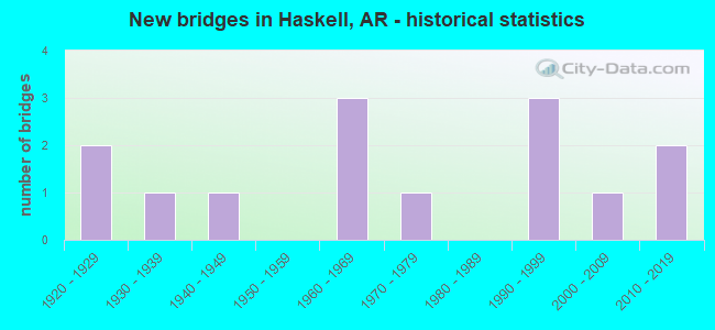
- New bridges - historical statistics
- 21920-1929
- 11930-1939
- 11940-1949
- 31960-1969
- 11970-1979
- 31990-1999
- 12000-2009
- 22010-2019
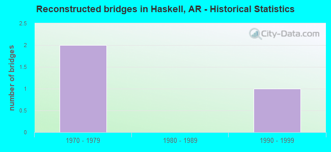
- Reconstructed bridges - Historical Statistics
- 21970-1979
- 01980-1989
- 11990-1999
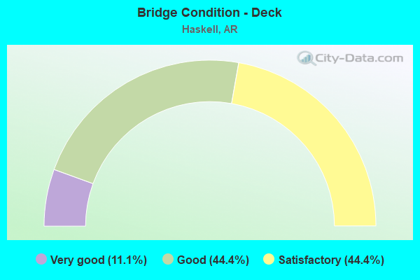
- Bridge Condition - Deck
- 11.1%Very good
- 44.4%Good
- 44.4%Satisfactory
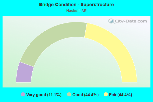
- Bridge Condition - Superstructure
- 11.1%Very good
- 44.4%Good
- 44.4%Fair
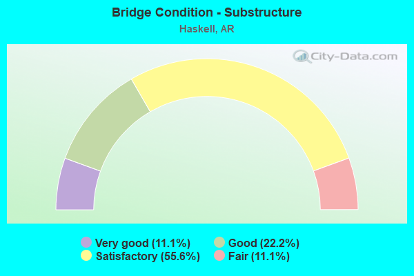
- Bridge Condition - Substructure
- 11.1%Very good
- 22.2%Good
- 55.6%Satisfactory
- 11.1%Fair
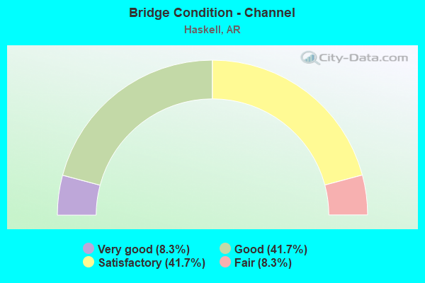
- Bridge Condition - Channel
- 8.3%Very good
- 41.7%Good
- 41.7%Satisfactory
- 8.3%Fair
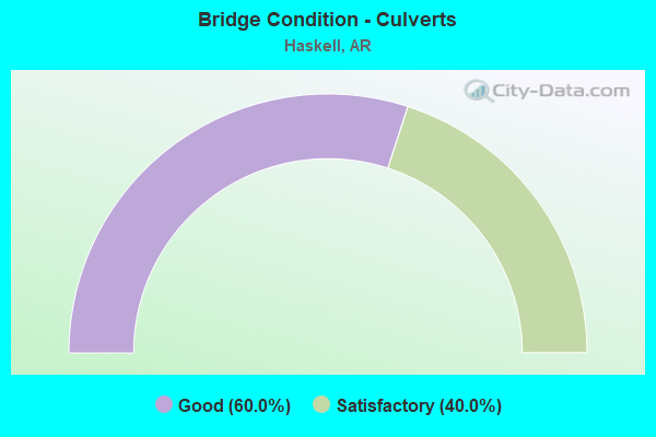
- Bridge Condition - Culverts
- 60.0%Good
- 40.0%Satisfactory
Find on map >> Show street view
Structure Number: 399, Location: 2.25 M S JCT SH 27 (Lat: 33.784694, Lng: -94.143944), Route carried "on" structure: County highway 407, Year Built: 1929, Status: Open, Structure Length: 10.49m (34.42ft), Average Daily Traffic: 14 (year 1987), Truck Traffic: 1%, Average Future Daily Traffic: 17 (year 2007), Design Load: H 15, Features Intersected: SAND SLOUGH
Minimum Vertical Clearance: 30+ m (98+ ft), Kilometerpoint: 3.621, Lanes on structure: 2, Owner: County Highway Agency, Approaching Roadway Width: 6.4m (21.0ft), Material/Design: Concrete, Design/Construction: Tee Beam, Number Of Spans In Main Unit: 10, Length of Maximum Span: 10.4m (34.1ft), Curb or Sidewalk Widths: Left: 0.2m (0.7ft), Right: 0.2m (0.7ft), Curb-To-Curb Width: 6.7m (22.0ft), Out-to-Out Width: 7.6m (24.9ft)
Condition: Deck: Good, Superstructure: Good, Substructure: Satisfactory, Channel: Satisfactory, Operating Rating: 54.4 metric tons, Method Used To Determine Operating Rating: Load Factor (LF), Inventory Rating: 32.7 metric tons, Method Used To Determine Inventory Rating: Load Factor (LF), Structural Evaluation: Equal to present minimum criteria, Deck Geometry: Somewhat better than minimum adequacy, Waterway Adequacy: Better than present minimum criteria, Approach Roadway Alignment: Meets minimum limits, Designated Inspection Frequency: Every 24 months, Critical Feature Inspection Frequency: Every 24 months, Inspection Date: Febuary 2022, Deck Structure Type: Concrete Cast-file-Place, Wearing Surface/Protective System: Wearing Surface: Monolithic Concrete
Find on map >> Show street view
Structure Number: 1438, Location: 2.41 MI SW JCT OF I-30 (Lat: 34.522500, Lng: -92.659100), Route carried "on" structure: US 67, Year Built: 1931, Status: Open, Structure Length: 2.13m (6.99ft), Average Daily Traffic: 3,900 (year 2018), Truck Traffic: 1%, Average Future Daily Traffic: 4,811 (year 2028), Design Load: H 15, Features Intersected: TRACE CREEK
Minimum Vertical Clearance: 30+ m (98+ ft), Kilometerpoint: 8.383, Lanes on structure: 2, Owner: State Highway Agency, Approaching Roadway Width: 12.2m (40.0ft), Skew: 4 degrees, Material/Design: Concrete, Design/Construction: Tee Beam, Number Of Spans In Main Unit: 2, Length of Maximum Span: 10.7m (35.1ft), Curb or Sidewalk Widths: Left: 0.1m (0.3ft), Right: 0.1m (0.3ft), Curb-To-Curb Width: 8.4m (27.6ft), Out-to-Out Width: 9.1m (29.9ft)
Condition: Deck: Satisfactory, Superstructure: Fair, Substructure: Satisfactory, Channel: Fair, Operating Rating: 54.4 metric tons, Method Used To Determine Operating Rating: Load Factor (LF), Inventory Rating: 32.7 metric tons, Method Used To Determine Inventory Rating: Load Factor (LF), Structural Evaluation: Somewhat better than minimum adequacy, Deck Geometry: High priority of corrective action, Waterway Adequacy: Equal to present desirable criteria, Approach Roadway Alignment: Equal to present desirable criteria, Length Of Structure Improvement: 2.90m (9.51ft), Designated Inspection Frequency: Every 24 months, Critical Feature Inspection Frequency: Every 24 months, Inspection Date: November 2021, Roadway Improvement Cost: $125,000, Total Project Cost: $316,000, Deck Structure Type: Concrete Cast-file-Place, Wearing Surface/Protective System: Wearing Surface: Bituminous
Find on map >> Show street view
Structure Number: 325, Location: 0.2 MI W OF I-30 (Lat: 34.533961, Lng: -92.679200), Route carried "on" structure: Ramp US 70, Year Built: 1960, Status: Open, Structure Length: 11.64m (38.19ft), Average Daily Traffic: 8,250 (year 2011), Truck Traffic: 1%, Average Future Daily Traffic: 4,400 (year 2028), Design Load: HS 20, Features Intersected: CR 32 Pawnee & Crk
Minimum Vertical Clearance: 30+ m (98+ ft), Kilometerpoint: 11.201, Lanes on structure: 1, Lanes under structure: 2, Owner: State Highway Agency, Approaching Roadway Width: 8.5m (27.9ft), Skew: 4 degrees, Material/Design: Steel, Design/Construction: Stringer/Multi-beam, Number Of Spans In Main Unit: 6, Length of Maximum Span: 20.4m (66.9ft), Curb or Sidewalk Widths: Left: 0.5m (1.6ft), Right: 0.5m (1.6ft), Curb-To-Curb Width: 8.5m (27.9ft), Out-to-Out Width: 10.1m (33.1ft)
Condition: Deck: Satisfactory, Superstructure: Fair, Substructure: Fair, Channel: Good, Operating Rating: 54.4 metric tons, Method Used To Determine Operating Rating: Load Factor (LF), Inventory Rating: 32.7 metric tons, Method Used To Determine Inventory Rating: Load Factor (LF), Structural Evaluation: Somewhat better than minimum adequacy, Deck Geometry: Superior to present desirable criteria, Underclear: Superior to present desirable criteria, Waterway Adequacy: Equal to present desirable criteria, Approach Roadway Alignment: Equal to present minimum criteria, Designated Inspection Frequency: Every 24 months, Critical Feature Inspection Frequency: Every 24 months, Inspection Date: Febuary 2022, Deck Structure Type: Concrete Cast-file-Place, Wearing Surface/Protective System: Wearing Surface: Monolithic Concrete
Find on map >> Show street view
Structure Number: 5831, Location: 2.7 MI N JCT SH 291&229 (Lat: 34.484169, Lng: -92.649889), Route carried "on" structure: State highway 229, Year Built: 1997, Status: Open, Structure Length: 4.57m (14.99ft), Average Daily Traffic: 1,800 (year 2018), Truck Traffic: 2%, Average Future Daily Traffic: 2,474 (year 2028), Design Load: HS 20, Features Intersected: CLIFT CREEK
Minimum Vertical Clearance: 30+ m (98+ ft), Kilometerpoint: 9.172, Lanes on structure: 2, Owner: State Highway Agency, Approaching Roadway Width: 7.3m (24.0ft), Material/Design: Concrete, Design/Construction: Slab, Number Of Spans In Main Unit: 5, Length of Maximum Span: 9.1m (29.9ft), Curb-To-Curb Width: 9.8m (32.2ft), Out-to-Out Width: 10.6m (34.8ft)
Condition: Deck: Good, Superstructure: Good, Substructure: Good, Channel: Good, Operating Rating: 54.4 metric tons, Method Used To Determine Operating Rating: Load Factor (LF), Inventory Rating: 32.7 metric tons, Method Used To Determine Inventory Rating: Load Factor (LF), Structural Evaluation: Better than present minimum criteria, Deck Geometry: Somewhat better than minimum adequacy, Waterway Adequacy: Equal to present desirable criteria, Approach Roadway Alignment: Equal to present desirable criteria, Designated Inspection Frequency: Every 24 months, Critical Feature Inspection Frequency: Every 24 months, Inspection Date: March 2020, Deck Structure Type: Concrete Cast-file-Place, Wearing Surface/Protective System: Wearing Surface: Monolithic Concrete
Find on map >> Show street view
Structure Number: 5832, Location: 3.8 M NO CR 291 (Lat: 34.502628, Lng: -92.643589), Route carried "on" structure: State highway 229, Year Built: 1997, Status: Open, Structure Length: 3.66m (12.01ft), Average Daily Traffic: 1,800 (year 2018), Truck Traffic: 2%, Average Future Daily Traffic: 2,400 (year 2038), Design Load: HS 20, Features Intersected: TRACE CREEK
Minimum Vertical Clearance: 30+ m (98+ ft), Kilometerpoint: 11.763, Lanes on structure: 2, Owner: State Highway Agency, Approaching Roadway Width: 7.3m (24.0ft), Skew: 4 degrees, Material/Design: Concrete, Design/Construction: Slab, Number Of Spans In Main Unit: 4, Length of Maximum Span: 9.1m (29.9ft), Curb-To-Curb Width: 9.8m (32.2ft), Out-to-Out Width: 10.6m (34.8ft)
Condition: Deck: Good, Superstructure: Good, Substructure: Good, Channel: Good, Operating Rating: 54.4 metric tons, Method Used To Determine Operating Rating: Load Factor (LF), Inventory Rating: 32.7 metric tons, Method Used To Determine Inventory Rating: Load Factor (LF), Structural Evaluation: Better than present minimum criteria, Deck Geometry: Somewhat better than minimum adequacy, Waterway Adequacy: Equal to present desirable criteria, Approach Roadway Alignment: Equal to present desirable criteria, Designated Inspection Frequency: Every 24 months, Critical Feature Inspection Frequency: Every 24 months, Inspection Date: March 2020, Deck Structure Type: Concrete Cast-file-Place, Wearing Surface/Protective System: Wearing Surface: Monolithic Concrete
Find on map >> Show street view
Structure Number: 16652, Location: 4.4 M W OF JCT US 67 (Lat: 34.532300, Lng: -92.714311), Route carried "on" structure: County highway 32, Year Built: 1972, Year Reconstructed: 1995, Status: Open, Structure Length: 0.76m (2.49ft), Average Daily Traffic: 325 (year 2018), Truck Traffic: 2%, Average Future Daily Traffic: 600 (year 2038), Features Intersected: CREEK
Minimum Vertical Clearance: 30+ m (98+ ft), Kilometerpoint: 6.902, Lanes on structure: 1, Owner: County Highway Agency, Approaching Roadway Width: 4.6m (15.1ft), Skew: 2 degrees, Material/Design: Steel, Design/Construction: Stringer/Multi-beam, Number Of Spans In Main Unit: 1, Length of Maximum Span: 7.6m (24.9ft), Curb-To-Curb Width: 3.7m (12.1ft), Out-to-Out Width: 4.1m (13.5ft)
Condition: Deck: Good, Superstructure: Good, Substructure: Satisfactory, Channel: Satisfactory, Operating Rating: 48.1 metric tons, Method Used To Determine Operating Rating: Load Factor (LF), Inventory Rating: 29.0 metric tons, Method Used To Determine Inventory Rating: Load Factor (LF), Structural Evaluation: Equal to present minimum criteria, Deck Geometry: High priority of replacement, Waterway Adequacy: Equal to present minimum criteria, Approach Roadway Alignment: Equal to present minimum criteria, Length Of Structure Improvement: 0.76m (2.49ft), Designated Inspection Frequency: Every 24 months, Critical Feature Inspection Frequency: Every 24 months, Inspection Date: November 2021, Total Project Cost: $16,000, Deck Structure Type: Corrugated Steel, Wearing Surface/Protective System: Wearing Surface: Bituminous
Find on map >> Show street view
Structure Number: 2122, Location: .6 MI WEST US 67 (Lat: 34.536433, Lng: -92.653936), Route carried "on" structure: County highway 32, Year Built: 1992, Status: Open, Structure Length: 1.31m (4.30ft), Average Daily Traffic: 978 (year 2018), Truck Traffic: 1%, Average Future Daily Traffic: 228 (year 2007), Features Intersected: DODSON CREEK
Minimum Vertical Clearance: 30+ m (98+ ft), Kilometerpoint: 0.982, Lanes on structure: 2, Owner: County Highway Agency, Approaching Roadway Width: 6.1m (20.0ft), Material/Design: Concrete, Design/Construction: Culvert, Number Of Spans In Main Unit: 4, Length of Maximum Span: 3.0m (9.8ft)
Condition: Channel: Satisfactory, Culverts: Good, Operating Rating: 39.9 metric tons, Method Used To Determine Operating Rating: Load Factor (LF), Inventory Rating: 23.6 metric tons, Method Used To Determine Inventory Rating: Load Factor (LF), Structural Evaluation: Equal to present minimum criteria, Waterway Adequacy: Equal to present desirable criteria, Approach Roadway Alignment: Equal to present desirable criteria, Designated Inspection Frequency: Every 24 months, Critical Feature Inspection Frequency: Every 24 months, Inspection Date: March 2021
Find on map >> Show street view
Structure Number: 23486, Location: 1Mile W HWY 67 (Lat: 34.526214, Lng: -92.662069), Route carried "on" structure: City street 59148, Year Built: 2011, Status: Open, Structure Length: 1.37m (4.49ft), Average Daily Traffic: 832 (year 2018), Truck Traffic: 1%, Average Future Daily Traffic: 55 (year 2031), Features Intersected: Trace Creek, Facility Carried by Structure: Valderrama Street
Minimum Vertical Clearance: 30+ m (98+ ft), Kilometerpoint: 0.161, Lanes on structure: 2, Owner: City or Municipal Highway Agency, Approaching Roadway Width: 7.3m (24.0ft), Material/Design: Concrete, Design/Construction: Culvert, Number Of Spans In Main Unit: 4, Length of Maximum Span: 3.0m (9.8ft), Curb or Sidewalk Widths: Left: 1.3m (4.3ft), Right: 0.2m (0.7ft), Curb-To-Curb Width: 7.3m (24.0ft), Out-to-Out Width: 8.3m (27.2ft)
Condition: Channel: Good, Culverts: Good, Operating Rating: 41.7 metric tons, Method Used To Determine Operating Rating: Load Factor (LF), Inventory Rating: 25.4 metric tons, Method Used To Determine Inventory Rating: Load Factor (LF), Structural Evaluation: Equal to present minimum criteria, Deck Geometry: Meets minimum limits, Waterway Adequacy: Equal to present minimum criteria, Approach Roadway Alignment: Equal to present minimum criteria, Designated Inspection Frequency: Every 24 months, Critical Feature Inspection Frequency: Every 24 months, Inspection Date: April 2021, Deck Structure Type: Concrete Cast-file-Place, Wearing Surface/Protective System: Wearing Surface: Monolithic Concrete
Find on map >> Show street view
Structure Number: 2384, Location: 0.10 Mi east of SH 229 (Lat: 34.526819, Lng: -92.644928), Route carried "on" structure: City street 16200, Year Built: 2017, Status: Open, Structure Length: 0.94m (3.08ft), Average Daily Traffic: 324 (year 2018), Truck Traffic: 1%, Average Future Daily Traffic: 115 (year 2037), Features Intersected: Dodson Creek, Facility Carried by Structure: Dodson Creek Rd
Minimum Vertical Clearance: 30.44m (99.87ft), Kilometerpoint: 0.161, Lanes on structure: 2, Owner: City or Municipal Highway Agency, Approaching Roadway Width: 7.6m (24.9ft), Material/Design: Concrete, Design/Construction: Channel Beam, Number Of Spans In Main Unit: 1, Length of Maximum Span: 8.4m (27.6ft), Curb-To-Curb Width: 7.4m (24.3ft), Out-to-Out Width: 7.7m (25.3ft)
Condition: Deck: Very good, Superstructure: Very good, Substructure: Very good, Channel: Very good, Operating Rating: 54.4 metric tons, Method Used To Determine Operating Rating: Load Factor (LF), Inventory Rating: 32.7 metric tons, Method Used To Determine Inventory Rating: Load Factor (LF), Structural Evaluation: Equal to present desirable criteria, Deck Geometry: Somewhat better than minimum adequacy, Waterway Adequacy: Superior to present desirable criteria, Approach Roadway Alignment: Equal to present desirable criteria, Designated Inspection Frequency: Every 24 months, Critical Feature Inspection Frequency: Every 24 months, Inspection Date: Febuary 2021, Deck Structure Type: Concrete Precast Panels, Wearing Surface/Protective System: Wearing Surface: Monolithic Concrete
Find on map >> Show street view
Structure Number: A3251, Location: 5.9 MI SW SH 5 @ BENTON (Lat: 34.533069, Lng: -92.677281), Route carried "on" structure: Interstate 30, Year Built: 1963, Year Reconstructed: 1984, Status: Open, Structure Length: 12.86m (42.19ft), Average Daily Traffic: 18,537 (year 2017), Truck Traffic: 1%, Average Future Daily Traffic: 20,617 (year 2028), Design Load: HS 20+Mod, Features Intersected: CR32;US70 EB & WB;CRK
Minimum Vertical Clearance: 30+ m (98+ ft), Kilometerpoint: 178.283, Lanes on structure: 2, Lanes under structure: 5, Base Highway Network: Yes, Owner: State Highway Agency, Approaching Roadway Width: 12.2m (40.0ft), Skew: 2 degrees, Material/Design: Steel, Design/Construction: Stringer/Multi-beam, Number Of Spans In Main Unit: 6, Length of Maximum Span: 22.9m (75.1ft), Curb-To-Curb Width: 12.2m (40.0ft), Out-to-Out Width: 13.1m (43.0ft)
Condition: Deck: Satisfactory, Superstructure: Fair, Substructure: Satisfactory, Operating Rating: 54.4 metric tons, Method Used To Determine Operating Rating: Load Factor (LF), Inventory Rating: 32.7 metric tons, Method Used To Determine Inventory Rating: Load Factor (LF), Structural Evaluation: Somewhat better than minimum adequacy, Deck Geometry: Better than present minimum criteria, Underclear: High priority of corrective action, Approach Roadway Alignment: Equal to present desirable criteria, Designated Inspection Frequency: Every 24 months, Critical Feature Inspection Frequency: Every 24 months, Inspection Date: August 2020, Deck Structure Type: Concrete Cast-file-Place, Wearing Surface/Protective System: Wearing Surface: Monolithic Concrete
Find on map >> Show street view
Structure Number: B3251, Location: 5.9 MI SW SH 5 @ BENTON (Lat: 34.533069, Lng: -92.677061), Route carried "on" structure: Interstate 30, Year Built: 1963, Year Reconstructed: 1984, Status: Open, Structure Length: 12.86m (42.19ft), Average Daily Traffic: 18,537 (year 2017), Truck Traffic: 1%, Average Future Daily Traffic: 20,617 (year 2028), Design Load: HS 20+Mod, Features Intersected: CR32;US 70 EB & WB;CRK
Minimum Vertical Clearance: 30+ m (98+ ft), Kilometerpoint: 178.283, Lanes on structure: 2, Lanes under structure: 5, Base Highway Network: Yes, Owner: State Highway Agency, Approaching Roadway Width: 12.2m (40.0ft), Skew: 2 degrees, Material/Design: Steel, Design/Construction: Stringer/Multi-beam, Number Of Spans In Main Unit: 6, Length of Maximum Span: 22.9m (75.1ft), Curb-To-Curb Width: 12.2m (40.0ft), Out-to-Out Width: 13.1m (43.0ft)
Condition: Deck: Satisfactory, Superstructure: Fair, Substructure: Satisfactory, Operating Rating: 54.4 metric tons, Method Used To Determine Operating Rating: Load Factor (LF), Inventory Rating: 32.7 metric tons, Method Used To Determine Inventory Rating: Load Factor (LF), Structural Evaluation: Somewhat better than minimum adequacy, Deck Geometry: Better than present minimum criteria, Underclear: High priority of corrective action, Approach Roadway Alignment: Equal to present desirable criteria, Designated Inspection Frequency: Every 24 months, Critical Feature Inspection Frequency: Every 24 months, Other Special Inspection Frequency: Every 24 months, Inspection Date: August 2020, Other Special Inspection Date: August 2021, Deck Structure Type: Concrete Cast-file-Place, Wearing Surface/Protective System: Wearing Surface: Monolithic Concrete
Find on map >> Show street view
Structure Number: M1234, Location: 3.14 MI NE HOT SPRINGS CO (Lat: 34.503831, Lng: -92.687439), Route carried "on" structure: US 67, Year Built: 1927, Status: Open, Structure Length: 0.67m (2.20ft), Average Daily Traffic: 3,633 (year 2018), Truck Traffic: 1%, Average Future Daily Traffic: 4,811 (year 2028), Design Load: H 15, Features Intersected: SOUTH BRANCH DEW DROP CR
Minimum Vertical Clearance: 30+ m (98+ ft), Kilometerpoint: 5.053, Lanes on structure: 2, Owner: State Highway Agency, Approaching Roadway Width: 12.2m (40.0ft), Material/Design: Concrete, Design/Construction: Culvert, Number Of Spans In Main Unit: 2, Length of Maximum Span: 3.0m (9.8ft)
Condition: Channel: Satisfactory, Culverts: Satisfactory, Operating Rating: 29.9 metric tons, Method Used To Determine Operating Rating: Load Factor (LF), Inventory Rating: 18.1 metric tons, Method Used To Determine Inventory Rating: Load Factor (LF), Structural Evaluation: Somewhat better than minimum adequacy, Waterway Adequacy: Equal to present desirable criteria, Approach Roadway Alignment: Equal to present desirable criteria, Designated Inspection Frequency: Every 24 months, Critical Feature Inspection Frequency: Every 24 months, Inspection Date: November 2021
Find on map >> Show street view
Structure Number: M1323, Location: 2.5 MI E SE OF NANCE (Lat: 34.538539, Lng: -92.715039), Route carried "on" structure: US 70, Year Built: 1940, Status: Open, Structure Length: 1.16m (3.81ft), Average Daily Traffic: 15,000 (year 2018), Truck Traffic: 10%, Average Future Daily Traffic: 15,800 (year 2038), Design Load: H 15, Features Intersected: ACHMUNE CREEK
Minimum Vertical Clearance: 30+ m (98+ ft), Kilometerpoint: 7.772, Lanes on structure: 2, Base Highway Network: Yes, Owner: State Highway Agency, Approaching Roadway Width: 14.0m (45.9ft), Skew: 3 degrees, Material/Design: Concrete, Design/Construction: Culvert, Number Of Spans In Main Unit: 3, Length of Maximum Span: 3.7m (12.1ft)
Condition: Channel: Good, Culverts: Good, Operating Rating: 26.3 metric tons, Method Used To Determine Operating Rating: Load Factor (LF), Inventory Rating: 16.3 metric tons, Method Used To Determine Inventory Rating: Load Factor (LF), Structural Evaluation: Meets minimum limits, Waterway Adequacy: Equal to present desirable criteria, Approach Roadway Alignment: Equal to present desirable criteria, Designated Inspection Frequency: Every 24 months, Critical Feature Inspection Frequency: Every 24 months, Inspection Date: January 2022
Find on map >> Show street view
Structure Number: X1043, Location: 1.55 MI S JCT I-30 (Lat: 34.530481, Lng: -92.647450), Route carried "on" structure: US 67, Year Built: 2001, Status: Open, Structure Length: 1.65m (5.41ft), Average Daily Traffic: 12,712 (year 2018), Truck Traffic: 3%, Average Future Daily Traffic: 16,494 (year 2028), Design Load: H 20, Features Intersected: DODSON CREEK
Minimum Vertical Clearance: 30+ m (98+ ft), Kilometerpoint: 9.785, Lanes on structure: 3, Owner: State Highway Agency, Approaching Roadway Width: 12.2m (40.0ft), Material/Design: Concrete, Design/Construction: Culvert, Number Of Spans In Main Unit: 4, Length of Maximum Span: 3.7m (12.1ft)
Condition: Channel: Satisfactory, Culverts: Satisfactory, Operating Rating: 31.8 metric tons, Method Used To Determine Operating Rating: Load Factor (LF), Inventory Rating: 19.1 metric tons, Method Used To Determine Inventory Rating: Load Factor (LF), Structural Evaluation: Meets minimum limits, Waterway Adequacy: Equal to present desirable criteria, Approach Roadway Alignment: Equal to present desirable criteria, Designated Inspection Frequency: Every 24 months, Critical Feature Inspection Frequency: Every 24 months, Inspection Date: November 2021
Find on map >> Show street view
Structure Number: 3249, Location: 1.01 Ml W Hwy 67 (Lat: 34.523339, Lng: -92.683661), Route carried "under" structure: Interstate 30, Structure Length: 0. m, Average Daily Traffic: 15,000 (year 2014), Truck Traffic: 1%, Features Intersected: 1-30 Log 110.01, Facility Carried by Structure: CR 23 Crossroads
Minimum Vertical Clearance: 4.84m (15.88ft), Kilometerpoint: 177.044, Length of Maximum Span: 0.0m
Find on map >> Show street view
Structure Number: 3249, Location: 1.01 Ml W Hwy 67 (Lat: 34.523339, Lng: -92.683661), Route carried "under" structure: Interstate 30, Structure Length: 0. m, Average Daily Traffic: 15,000 (year 2014), Truck Traffic: 1%, Features Intersected: 1-30 Log 110.01, Facility Carried by Structure: CR 23 Crossroads
Minimum Vertical Clearance: 4.87m (15.98ft), Kilometerpoint: 177.044, Length of Maximum Span: 0.0m
Find on map >> Show street view
Structure Number: 325, Location: 0.2 MI W OF I-30 (Lat: 34.533961, Lng: -92.679200), Route carried "under" structure: County highway 32, Structure Length: 0. m, Average Daily Traffic: 1,000 (year 2003), Truck Traffic: 1%, Features Intersected: CR 32 Pawnee & Crk, Facility Carried by Structure: US 70 EB to I-30 W
Minimum Vertical Clearance: 7.55m (24.77ft), Kilometerpoint: 3.380, Length of Maximum Span: 0.0m
Find on map >> Show street view
Structure Number: A3251, Location: 5.9 MI SW SH 5 @ BENTON (Lat: 34.533069, Lng: -92.677281), Route carried "under" structure: US 70, Structure Length: 0. m, Average Daily Traffic: 7,000 (year 2014), Truck Traffic: 1%, Features Intersected: CR32;US70 EB & WB;CRK, Facility Carried by Structure: I30-WB log 110.78
Minimum Vertical Clearance: 4.49m (14.73ft), Kilometerpoint: 11.410, Length of Maximum Span: 0.0m
Find on map >> Show street view
Structure Number: A3251, Location: 5.9 MI SW SH 5 @ BENTON (Lat: 34.533069, Lng: -92.677281), Route carried "under" structure: US 70, Structure Length: 0. m, Average Daily Traffic: 7,000 (year 2014), Truck Traffic: 1%, Features Intersected: CR32;US70 EB & WB;CRK, Facility Carried by Structure: I30-WB log 110.78
Minimum Vertical Clearance: 4.81m (15.78ft), Kilometerpoint: 11.410, Length of Maximum Span: 0.0m
Find on map >> Show street view
Structure Number: A3251, Location: 5.9 MI SW SH 5 @ BENTON (Lat: 34.533069, Lng: -92.677281), Route carried "under" structure: County highway 32, Structure Length: 0. m, Average Daily Traffic: 260 (year 1983), Truck Traffic: 1%, Features Intersected: CR32;US70 EB & WB;CRK, Facility Carried by Structure: I30-WB log 110.78
Minimum Vertical Clearance: 4.72m (15.49ft), Kilometerpoint: 3.235, Length of Maximum Span: 0.0m
Find on map >> Show street view
Structure Number: B3251, Location: 5.9 MI SW SH 5 @ BENTON (Lat: 34.533069, Lng: -92.677061), Route carried "under" structure: US 70, Structure Length: 0. m, Average Daily Traffic: 7,000 (year 2014), Truck Traffic: 1%, Features Intersected: CR32;US 70 EB & WB;CRK, Facility Carried by Structure: I30-EB 110.78
Minimum Vertical Clearance: 4.93m (16.17ft), Kilometerpoint: 11.426, Length of Maximum Span: 0.0m
Find on map >> Show street view
Structure Number: B3251, Location: 5.9 MI SW SH 5 @ BENTON (Lat: 34.533069, Lng: -92.677061), Route carried "under" structure: County highway 32, Structure Length: 0. m, Average Daily Traffic: 260 (year 1983), Truck Traffic: 1%, Features Intersected: CR32;US 70 EB & WB;CRK, Facility Carried by Structure: I30-EB 110.78
Minimum Vertical Clearance: 5.02m (16.47ft), Kilometerpoint: 3.380, Length of Maximum Span: 0.0m
Find on map >> Show street view
Structure Number: B3251, Location: 5.9 MI SW SH 5 @ BENTON (Lat: 34.533069, Lng: -92.677061), Route carried "under" structure: US 70, Structure Length: 0. m, Average Daily Traffic: 7,000 (year 2014), Truck Traffic: 1%, Features Intersected: CR32;US 70 EB & WB;CRK, Facility Carried by Structure: I30-EB 110.78
Minimum Vertical Clearance: 4.54m (14.90ft), Kilometerpoint: 11.426, Length of Maximum Span: 0.0m