Bridge Statistics for Hesperia, California (CA)
Condition, Traffic, Stress, Structural Evaluation, Project Costs
- National Bridge Inventory (NBI) Statistics
- 33Number of bridges
- 443ft / 135mTotal length
- $1,154,000Total costs
- 1,091,932Total average daily traffic
- 149,639Total average daily truck traffic
- National Bridge Inventory (NBI) Registered Bridges for Hesperia
- No street view available for this location
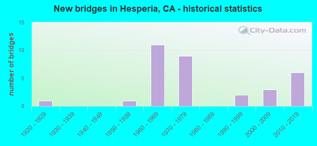
- New bridges - historical statistics
- 11920-1929
- 11950-1959
- 111960-1969
- 91970-1979
- 21990-1999
- 32000-2009
- 62010-2019
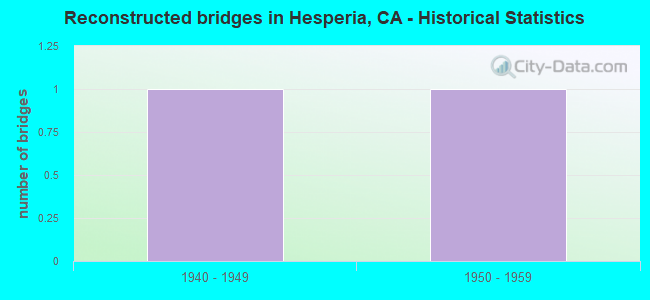
- Reconstructed bridges - Historical Statistics
- 11940-1949
- 11950-1959
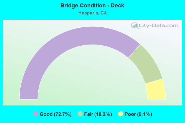
- Bridge Condition - Deck
- 72.7%Good
- 18.2%Fair
- 9.1%Poor
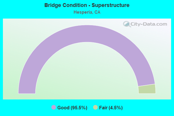
- Bridge Condition - Superstructure
- 95.5%Good
- 4.5%Fair
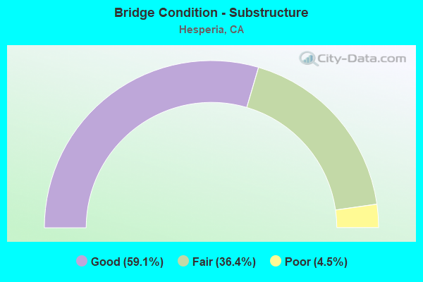
- Bridge Condition - Substructure
- 59.1%Good
- 36.4%Fair
- 4.5%Poor
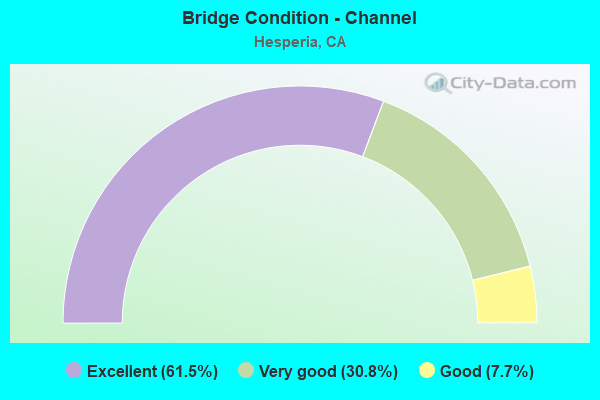
- Bridge Condition - Channel
- 61.5%Excellent
- 30.8%Very good
- 7.7%Good
Find on map >> Show street view
Structure Number: 54 0664L, Location: 08-SBD-015-31.08 (Lat: 34.391381, Lng: -117.408592), Route carried "on" structure: Interstate 15, Year Built: 1966, Status: Open, Structure Length: 3.78m (12.40ft), Average Daily Traffic: 72,000 (year 2017), Truck Traffic: 14%, Average Future Daily Traffic: 90,000 (year 2040), Design Load: HS 20+Mod, Features Intersected: BNSF RY, UP RR, & AMTRAK
Minimum Vertical Clearance: 30+ m (98+ ft), Kilometerpoint: 31.080, Lanes on structure: 4, Base Highway Network: Yes (, Subroute: 1), Owner: State Highway Agency, Approaching Roadway Width: 20.1m (65.9ft), Skew: 1 degrees, Material/Design: Concrete continuous, Design/Construction: Slab, Number Of Spans In Main Unit: 5, Length of Maximum Span: 9.4m (30.8ft), Curb-To-Curb Width: 20.1m (65.9ft), Out-to-Out Width: 20.7m (67.9ft)
Condition: Deck: Good, Superstructure: Good, Substructure: Good, Operating Rating: 69.7 metric tons, Method Used To Determine Operating Rating: Load Factor (LF), Inventory Rating: 41.8 metric tons, Method Used To Determine Inventory Rating: Load Factor (LF), Structural Evaluation: Better than present minimum criteria, Deck Geometry: Equal to present minimum criteria, Underclear: Meets minimum limits, Approach Roadway Alignment: Equal to present desirable criteria, Designated Inspection Frequency: Every 24 months, Inspection Date: April 2020, Deck Structure Type: Concrete Cast-file-Place
Find on map >> Show street view
Structure Number: 54 0664R, Location: 08-SBD-015-31.08 (Lat: 34.391183, Lng: -117.408375), Route carried "on" structure: Interstate 15, Year Built: 1966, Status: Open, Structure Length: 3.77m (12.37ft), Average Daily Traffic: 72,000 (year 2017), Truck Traffic: 14%, Average Future Daily Traffic: 90,000 (year 2040), Design Load: HS 20+Mod, Features Intersected: BNSF RY, UP RR, & AMTRAK
Minimum Vertical Clearance: 30+ m (98+ ft), Kilometerpoint: 31.080, Lanes on structure: 4, Base Highway Network: Yes (, Subroute: 1), Owner: State Highway Agency, Approaching Roadway Width: 20.1m (65.9ft), Skew: 1 degrees, Material/Design: Concrete continuous, Design/Construction: Slab, Number Of Spans In Main Unit: 5, Length of Maximum Span: 9.4m (30.8ft), Curb-To-Curb Width: 20.1m (65.9ft), Out-to-Out Width: 20.7m (67.9ft)
Condition: Deck: Good, Superstructure: Good, Substructure: Good, Operating Rating: 69.7 metric tons, Method Used To Determine Operating Rating: Load Factor (LF), Inventory Rating: 41.8 metric tons, Method Used To Determine Inventory Rating: Load Factor (LF), Structural Evaluation: Better than present minimum criteria, Deck Geometry: Equal to present minimum criteria, Underclear: Meets minimum limits, Approach Roadway Alignment: Equal to present desirable criteria, Designated Inspection Frequency: Every 24 months, Inspection Date: April 2020, Deck Structure Type: Concrete Cast-file-Place
Find on map >> Show street view
Structure Number: 54 0665G, Location: 08-SBD-015-31.81 (Lat: 34.400439, Lng: -117.401278), Route carried "on" structure: Ramp Interstate 15, Year Built: 1964, Status: Open, Structure Length: 11.22m (36.81ft), Average Daily Traffic: 26,500 (year 2017), Truck Traffic: 22%, Average Future Daily Traffic: 36,000 (year 2040), Design Load: HS 20, Features Intersected: INTERSTATE 15
Minimum Vertical Clearance: 30+ m (98+ ft), Kilometerpoint: 31.810, Lanes on structure: 2, Lanes under structure: 6, Base Highway Network: Yes (, Subroute: 1), Owner: State Highway Agency, Approaching Roadway Width: 8.8m (28.9ft), Skew: 5 degrees, Material/Design: Steel, Design/Construction: Stringer/Multi-beam, Number Of Spans In Main Unit: 4, Length of Maximum Span: 39.0m (128.0ft), Curb or Sidewalk Widths: Left: 0.6m (2.0ft), Right: 0.6m (2.0ft), Curb-To-Curb Width: 8.5m (27.9ft), Out-to-Out Width: 10.4m (34.1ft)
Condition: Deck: Good, Superstructure: Good, Substructure: Fair, Operating Rating: 44.1 metric tons, Method Used To Determine Operating Rating: Load and Resistance Factor Rating (LRFR) rating reported by rating factor(RF) method using HL-93 loadings, Inventory Rating: 34.0 metric tons, Method Used To Determine Inventory Rating: Load and Resistance Factor Rating (LRFR) rating reported by rating factor(RF) method using HL-93 loadings, Structural Evaluation: Somewhat better than minimum adequacy, Deck Geometry: High priority of corrective action, Underclear: High priority of corrective action, Approach Roadway Alignment: Equal to present minimum criteria, Designated Inspection Frequency: Every 24 months, Critical Feature Inspection Frequency: Every 24 months, Inspection Date: April 2020, Critical Feature Inspection Date: December 2020, Deck Structure Type: Concrete Cast-file-Place, Wearing Surface/Protective System: Wearing Surface: Integral Concrete
Find on map >> Show street view
Structure Number: 54 0666, Location: 08-SBD-015-32.32 (Lat: 34.406325, Lng: -117.396675), Route carried "on" structure: County highway , Year Built: 1964, Status: Open, Structure Length: 6.34m (20.80ft), Average Daily Traffic: 2,500 (year 2020), Truck Traffic: 10%, Average Future Daily Traffic: 3,200 (year 2040), Design Load: HS 20, Features Intersected: INTERSTATE 15, Facility Carried by Structure: JOSHUA STREET
Minimum Vertical Clearance: 30+ m (98+ ft), Kilometerpoint: 0.000, Lanes on structure: 2, Lanes under structure: 6, Owner: State Highway Agency, Approaching Roadway Width: 8.6m (28.2ft), Material/Design: Steel, Design/Construction: Stringer/Multi-beam, Number Of Spans In Main Unit: 4, Length of Maximum Span: 21.6m (70.9ft), Curb or Sidewalk Widths: Left: 0.6m (2.0ft), Right: 0.6m (2.0ft), Curb-To-Curb Width: 8.6m (28.2ft), Out-to-Out Width: 10.4m (34.1ft)
Condition: Deck: Poor, Superstructure: Good, Substructure: Good, Operating Rating: 56.4 metric tons, Method Used To Determine Operating Rating: Load Factor (LF), Inventory Rating: 33.7 metric tons, Method Used To Determine Inventory Rating: Load Factor (LF), Structural Evaluation: Better than present minimum criteria, Deck Geometry: Meets minimum limits, Underclear: High priority of corrective action, Approach Roadway Alignment: Equal to present desirable criteria, Designated Inspection Frequency: Every 24 months, Critical Feature Inspection Frequency: Every 24 months, Inspection Date: April 2020, Critical Feature Inspection Date: December 2020, Deck Structure Type: Concrete Cast-file-Place, Wearing Surface/Protective System: Wearing Surface: Integral Concrete
Find on map >> Show street view
Structure Number: 54 0828, Location: 08-SBD-015-34.34-HES (Lat: 34.430794, Lng: -117.376856), Route carried "on" structure: Interstate 15, Year Built: 1968, Status: Open, Structure Length: 1.31m (4.30ft), Average Daily Traffic: 100,000 (year 2017), Truck Traffic: 16%, Average Future Daily Traffic: 120,000 (year 2040), Design Load: HS 20+Mod, Features Intersected: CALIFORNIA AQUEDUCT
Minimum Vertical Clearance: 30+ m (98+ ft), Kilometerpoint: 34.340, Lanes on structure: 6, Base Highway Network: Yes (, Subroute: 1), Owner: State Highway Agency, Approaching Roadway Width: 40.2m (131.9ft), Skew: 1 degrees, Material/Design: Concrete continuous, Design/Construction: Culvert, Number Of Spans In Main Unit: 2, Length of Maximum Span: 6.4m (21.0ft)
Condition: Channel: Excellent, Culverts: Satisfactory, Operating Rating: 54.1 metric tons, Method Used To Determine Operating Rating: Field evaluation and documented engineering judgment, Inventory Rating: 32.4 metric tons, Method Used To Determine Inventory Rating: Field evaluation and documented engineering judgment, Structural Evaluation: Equal to present minimum criteria, Waterway Adequacy: Superior to present desirable criteria, Approach Roadway Alignment: Equal to present desirable criteria, Designated Inspection Frequency: Every 24 months, Underwater Inspection Frequency: Every 72 months, Inspection Date: March 2020, Underwater Inspection Date: March 2018
Find on map >> Show street view
Structure Number: 54 0846, Location: 08-SBD-138-R26.48 (Lat: 34.288072, Lng: -117.355300), Route carried "on" structure: State highway 138, Year Built: 1968, Status: Open, Structure Length: 5.36m (17.59ft), Average Daily Traffic: 1,550 (year 2017), Truck Traffic: 6%, Average Future Daily Traffic: 2,000 (year 2040), Design Load: HS 20, Features Intersected: WEST FORK MOJAVE RIVER
Minimum Vertical Clearance: 30+ m (98+ ft), Kilometerpoint: 26.480, Lanes on structure: 2, Lanes under structure: 2, Base Highway Network: Yes (Inventory Route: 1, Subroute: 1), Owner: State Highway Agency, Approaching Roadway Width: 12.2m (40.0ft), Skew: 3 degrees, Material/Design: Concrete continuous, Design/Construction: Box Beam or Girders - Multiple, Number Of Spans In Main Unit: 3, Length of Maximum Span: 28.7m (94.2ft), Curb-To-Curb Width: 12.2m (40.0ft), Out-to-Out Width: 12.8m (42.0ft)
Condition: Deck: Good, Superstructure: Fair, Substructure: Poor, Channel: Very good, Operating Rating: 56.7 metric tons, Method Used To Determine Operating Rating: Load and Resistance Factor Rating (LRFR) rating reported by rating factor(RF) method using HL-93 loadings, Inventory Rating: 41.5 metric tons, Method Used To Determine Inventory Rating: Load and Resistance Factor Rating (LRFR) rating reported by rating factor(RF) method using HL-93 loadings, Structural Evaluation: Meets minimum limits, Deck Geometry: Better than present minimum criteria, Underclear: Meets minimum limits, Waterway Adequacy: Equal to present desirable criteria, Approach Roadway Alignment: Equal to present desirable criteria, Length Of Structure Improvement: 5.36m (17.59ft), Designated Inspection Frequency: Every 24 months, Inspection Date: September 2020, Bridge Improvement Cost: $687,000, Roadway Improvement Cost: $137,000, Total Project Cost: $1,154,000 ( Estimate for 2019), Deck Structure Type: Concrete Cast-file-Place, Wearing Surface/Protective System: Wearing Surface: Integral Concrete
Find on map >> Show street view
Structure Number: 54 0874, Location: 08-SBD-173-L1.92 (Lat: 34.309139, Lng: -117.317786), Route carried "on" structure: State highway 173, Year Built: 1970, Status: Open, Structure Length: 10.06m (33.01ft), Average Daily Traffic: 1,150 (year 2017), Truck Traffic: 4%, Average Future Daily Traffic: 1,500 (year 2040), Design Load: HS 20, Features Intersected: CEDAR SPRINGS SPILLWAY
Minimum Vertical Clearance: 30+ m (98+ ft), Kilometerpoint: 1.920, Lanes on structure: 2, Owner: State Highway Agency, Approaching Roadway Width: 9.8m (32.2ft), Material/Design: Concrete continuous, Design/Construction: Box Beam or Girders - Multiple, Number Of Spans In Main Unit: 3, Length of Maximum Span: 39.6m (129.9ft), Curb or Sidewalk Widths: Left: 0.0m, Right: 1.5m (4.9ft), Curb-To-Curb Width: 9.8m (32.2ft), Out-to-Out Width: 11.9m (39.0ft)
Condition: Deck: Fair, Superstructure: Good, Substructure: Good, Channel: Very good, Operating Rating: 99.8 metric tons, Method Used To Determine Operating Rating: Allowable Stress (AS), Inventory Rating: 50.2 metric tons, Method Used To Determine Inventory Rating: Allowable Stress (AS), Structural Evaluation: Better than present minimum criteria, Deck Geometry: Somewhat better than minimum adequacy, Waterway Adequacy: Superior to present desirable criteria, Approach Roadway Alignment: Equal to present desirable criteria, Designated Inspection Frequency: Every 24 months, Inspection Date: September 2020, Deck Structure Type: Concrete Cast-file-Place
Find on map >> Show street view
Structure Number: 54 1176, Location: 08-SBD-015-R28.62 (Lat: 34.362414, Lng: -117.433658), Route carried "on" structure: County highway , Year Built: 1997, Status: Open, Structure Length: 7.80m (25.59ft), Average Daily Traffic: 3,300 (year 2020), Truck Traffic: 4%, Average Future Daily Traffic: 4,000 (year 2040), Design Load: HS 20+Mod, Features Intersected: INTERSTATE 15, Facility Carried by Structure: OAK HILL ROAD
Minimum Vertical Clearance: 30+ m (98+ ft), Kilometerpoint: 0.000, Lanes on structure: 2, Lanes under structure: 9, Owner: State Highway Agency, Approaching Roadway Width: 9.8m (32.2ft), Material/Design: Prestressed concrete continuous, Design/Construction: Box Beam or Girders - Multiple, Number Of Spans In Main Unit: 2, Length of Maximum Span: 41.0m (134.5ft), Curb or Sidewalk Widths: Left: 0.0m, Right: 1.5m (4.9ft), Curb-To-Curb Width: 9.8m (32.2ft), Out-to-Out Width: 12.1m (39.7ft)
Condition: Deck: Good, Superstructure: Good, Substructure: Good, Operating Rating: 54.1 metric tons, Method Used To Determine Operating Rating: Assigned rating based on Load Factor Design (LFD) reported in metric tons, Inventory Rating: 32.4 metric tons, Method Used To Determine Inventory Rating: Assigned rating based on Load Factor Design (LFD) reported in metric tons, Structural Evaluation: Better than present minimum criteria, Deck Geometry: Meets minimum limits, Underclear: Somewhat better than minimum adequacy, Approach Roadway Alignment: Superior to present desirable criteria, Designated Inspection Frequency: Every 24 months, Inspection Date: May 2020, Deck Structure Type: Concrete Cast-file-Place, Wearing Surface/Protective System: Deck Protection: Epoxy Coated Reinforcing
Find on map >> Show street view
Structure Number: 54 1270L, Location: 08-SBD-040-R107.56 (Lat: 34.813278, Lng: -115.183903), Route carried "on" structure: Interstate 40, Year Built: 2006, Status: Open, Structure Length: 8.15m (26.74ft), Average Daily Traffic: 7,500 (year 2019), Truck Traffic: 42%, Average Future Daily Traffic: 11,669 (year 2041), Design Load: HS 20, Features Intersected: BNSF RY & AMTRAK
Minimum Vertical Clearance: 30+ m (98+ ft), Kilometerpoint: 107.560, Lanes on structure: 2, Base Highway Network: Yes (, Subroute: 1), Owner: State Highway Agency, Approaching Roadway Width: 11.7m (38.4ft), Skew: 5 degrees, Material/Design: Prestressed concrete continuous, Design/Construction: Stringer/Multi-beam, Number Of Spans In Main Unit: 3, Length of Maximum Span: 36.5m (119.8ft), Curb-To-Curb Width: 11.7m (38.4ft), Out-to-Out Width: 12.8m (42.0ft)
Condition: Deck: Poor, Superstructure: Good, Substructure: Good, Operating Rating: 54.1 metric tons, Method Used To Determine Operating Rating: Assigned rating based on Load Factor Design (LFD) reported in metric tons, Inventory Rating: 32.4 metric tons, Method Used To Determine Inventory Rating: Assigned rating based on Load Factor Design (LFD) reported in metric tons, Structural Evaluation: Better than present minimum criteria, Deck Geometry: Equal to present minimum criteria, Underclear: Better than present minimum criteria, Approach Roadway Alignment: Equal to present desirable criteria, Designated Inspection Frequency: Every 24 months, Inspection Date: Febuary 2021, Deck Structure Type: Concrete Cast-file-Place
Find on map >> Show street view
Structure Number: 54 1271, Location: 08-SBD-138-R24.11 (Lat: 34.310194, Lng: -117.345931), Route carried "on" structure: State highway 138, Year Built: 2016, Status: Open, Structure Length: 8.89m (29.17ft), Average Daily Traffic: 1,550 (year 2017), Truck Traffic: 6%, Average Future Daily Traffic: 2,000 (year 2040), Design Load: HL 93, Features Intersected: HORSETHIEF CREEK
Minimum Vertical Clearance: 30+ m (98+ ft), Kilometerpoint: 24.110, Lanes on structure: 2, Base Highway Network: Yes, Owner: State Highway Agency, Approaching Roadway Width: 13.4m (44.0ft), Skew: 6 degrees, Material/Design: Prestressed concrete, Design/Construction: Stringer/Multi-beam, Number Of Spans In Main Unit: 3, Length of Maximum Span: 56.4m (185.0ft), Curb-To-Curb Width: 13.4m (44.0ft), Out-to-Out Width: 14.5m (47.6ft)
Condition: Deck: Good, Superstructure: Good, Substructure: Good, Channel: Excellent, Operating Rating: 42.1 metric tons, Method Used To Determine Operating Rating: Assigned ratings based on Load and Resistance Factor Design (LRFD) reported by rating factor (RF) using HL93 loadings, Inventory Rating: 32.4 metric tons, Method Used To Determine Inventory Rating: Assigned ratings based on Load and Resistance Factor Design (LRFD) reported by rating factor (RF) using HL93 loadings, Structural Evaluation: Better than present minimum criteria, Deck Geometry: Equal to present desirable criteria, Waterway Adequacy: Superior to present desirable criteria, Approach Roadway Alignment: Equal to present desirable criteria, Designated Inspection Frequency: Every 24 months, Inspection Date: September 2020, Deck Structure Type: Concrete Cast-file-Place, Wearing Surface/Protective System: Deck Protection: Epoxy Coated Reinforcing
Find on map >> Show street view
Structure Number: 54 1273, Location: 08-SBD-015-34.00-HES (Lat: 34.426633, Lng: -117.380883), Route carried "on" structure: County highway , Year Built: 2005, Status: Open, Structure Length: 9.52m (31.23ft), Average Daily Traffic: 20,000 (year 2015), Truck Traffic: 10%, Average Future Daily Traffic: 24,000 (year 2040), Design Load: HS 20+Mod, Features Intersected: INTERSTATE 15, Facility Carried by Structure: MAIN STREET
Minimum Vertical Clearance: 30+ m (98+ ft), Kilometerpoint: 0.000, Lanes on structure: 6, Lanes under structure: 8, Owner: State Highway Agency, Approaching Roadway Width: 27.6m (90.6ft), Skew: 23 degrees, Material/Design: Prestressed concrete continuous, Design/Construction: Box Beam or Girders - Multiple, Number Of Spans In Main Unit: 2, Length of Maximum Span: 48.1m (157.8ft), Curb or Sidewalk Widths: Left: 1.5m (4.9ft), Right: 1.5m (4.9ft), Curb-To-Curb Width: 27.6m (90.6ft), Out-to-Out Width: 31.2m (102.4ft)
Condition: Deck: Good, Superstructure: Good, Substructure: Good, Operating Rating: 52.2 metric tons, Method Used To Determine Operating Rating: Load and Resistance Factor Rating (LRFR) rating reported by rating factor(RF) method using HL-93 loadings, Inventory Rating: 39.5 metric tons, Method Used To Determine Inventory Rating: Load and Resistance Factor Rating (LRFR) rating reported by rating factor(RF) method using HL-93 loadings, Structural Evaluation: Better than present minimum criteria, Deck Geometry: Better than present minimum criteria, Underclear: Meets minimum limits, Approach Roadway Alignment: Equal to present desirable criteria, Designated Inspection Frequency: Every 24 months, Inspection Date: March 2020, Deck Structure Type: Concrete Cast-file-Place
Find on map >> Show street view
Structure Number: 54 1285, Location: 08-SBD-015-30.37-HES (Lat: 34.383472, Lng: -117.411111), Route carried "on" structure: County highway , Year Built: 2015, Status: Open, Structure Length: 11.58m (37.99ft), Average Daily Traffic: 1,000 (year 2015), Truck Traffic: 3%, Average Future Daily Traffic: 2,000 (year 2040), Design Load: HL 93, Features Intersected: INTERSTATE 15, Facility Carried by Structure: RANCHERO ROAD
Minimum Vertical Clearance: 30+ m (98+ ft), Kilometerpoint: 0.000, Lanes on structure: 7, Lanes under structure: 9, Owner: State Highway Agency, Approaching Roadway Width: 36.5m (119.8ft), Skew: 23 degrees, Material/Design: Concrete continuous, Design/Construction: Box Beam or Girders - Multiple, Number Of Spans In Main Unit: 2, Length of Maximum Span: 59.8m (196.2ft), Curb or Sidewalk Widths: Left: 0.0m, Right: 1.5m (4.9ft), Curb-To-Curb Width: 36.5m (119.8ft), Out-to-Out Width: 42.5m (139.4ft)
Condition: Deck: Good, Superstructure: Good, Substructure: Good, Operating Rating: 42.1 metric tons, Method Used To Determine Operating Rating: Assigned ratings based on Load and Resistance Factor Design (LRFD) reported by rating factor (RF) using HL93 loadings, Inventory Rating: 32.4 metric tons, Method Used To Determine Inventory Rating: Assigned ratings based on Load and Resistance Factor Design (LRFD) reported by rating factor (RF) using HL93 loadings, Structural Evaluation: Better than present minimum criteria, Deck Geometry: Superior to present desirable criteria, Underclear: Better than present minimum criteria, Approach Roadway Alignment: Equal to present desirable criteria, Designated Inspection Frequency: Every 24 months, Inspection Date: March 2020, Deck Structure Type: Concrete Cast-file-Place, Wearing Surface/Protective System: Deck Protection: Epoxy Coated Reinforcing
Find on map >> Show street view
Structure Number: 54C0134, Location: 100' S/E OF ROUTE 15 (Lat: 34.390992, Lng: -117.408228), Route carried "on" structure: County highway , Year Built: 1967, Status: Open, Structure Length: 3.78m (12.40ft), Average Daily Traffic: 2,864 (year 2009), Truck Traffic: 5%, Average Future Daily Traffic: 2,261 (year 2044), Features Intersected: UP RR, Facility Carried by Structure: MARIPOSA RD
Minimum Vertical Clearance: 30+ m (98+ ft), Kilometerpoint: 0.000, Lanes on structure: 2, Owner: City or Municipal Highway Agency, Approaching Roadway Width: 7.6m (24.9ft), Skew: 1 degrees, Material/Design: Concrete continuous, Design/Construction: Slab, Number Of Spans In Main Unit: 5, Length of Maximum Span: 9.4m (30.8ft), Curb-To-Curb Width: 12.2m (40.0ft), Out-to-Out Width: 12.8m (42.0ft)
Condition: Deck: Good, Superstructure: Good, Substructure: Good, Operating Rating: 48.3 metric tons, Method Used To Determine Operating Rating: Load and Resistance Factor Rating (LRFR) rating reported by rating factor(RF) method using HL-93 loadings, Inventory Rating: 35.3 metric tons, Method Used To Determine Inventory Rating: Load and Resistance Factor Rating (LRFR) rating reported by rating factor(RF) method using HL-93 loadings, Structural Evaluation: Better than present minimum criteria, Deck Geometry: Equal to present minimum criteria, Underclear: Meets minimum limits, Approach Roadway Alignment: Equal to present desirable criteria, Designated Inspection Frequency: Every 48 months, Inspection Date: January 2022, Deck Structure Type: Concrete Cast-file-Place, Wearing Surface/Protective System: Wearing Surface: Bituminous
Find on map >> Show street view
Structure Number: 54C0135, Location: 80' NW OF RTE 15 (Lat: 34.391525, Lng: -117.408794), Route carried "on" structure: County highway , Year Built: 1966, Status: Open, Structure Length: 3.72m (12.20ft), Average Daily Traffic: 1,208 (year 2004), Truck Traffic: 1%, Average Future Daily Traffic: 1,667 (year 2044), Features Intersected: UP RR, Facility Carried by Structure: CALIENTE RD
Minimum Vertical Clearance: 30+ m (98+ ft), Kilometerpoint: 0.000, Lanes on structure: 2, Owner: City or Municipal Highway Agency, Approaching Roadway Width: 7.6m (24.9ft), Skew: 1 degrees, Material/Design: Concrete continuous, Design/Construction: Slab, Number Of Spans In Main Unit: 5, Length of Maximum Span: 9.4m (30.8ft), Curb-To-Curb Width: 12.2m (40.0ft), Out-to-Out Width: 12.8m (42.0ft)
Condition: Deck: Good, Superstructure: Good, Substructure: Good, Operating Rating: 48.6 metric tons, Method Used To Determine Operating Rating: Load and Resistance Factor Rating (LRFR) rating reported by rating factor(RF) method using HL-93 loadings, Inventory Rating: 35.3 metric tons, Method Used To Determine Inventory Rating: Load and Resistance Factor Rating (LRFR) rating reported by rating factor(RF) method using HL-93 loadings, Structural Evaluation: Better than present minimum criteria, Deck Geometry: Better than present minimum criteria, Underclear: Meets minimum limits, Approach Roadway Alignment: Equal to present desirable criteria, Designated Inspection Frequency: Every 48 months, Inspection Date: January 2022, Deck Structure Type: Concrete Cast-file-Place, Wearing Surface/Protective System: Wearing Surface: Bituminous
Find on map >> Show street view
Structure Number: 54C0184, Location: 0.7 MI E OF RTE 15 (Lat: 34.426606, Lng: -117.369322), Route carried "on" structure: City street , Year Built: 1970, Status: Open, Structure Length: 3.81m (12.50ft), Average Daily Traffic: 27,667 (year 2004), Truck Traffic: 3%, Average Future Daily Traffic: 38,529 (year 2044), Design Load: HS 20, Features Intersected: CALIFORNIA AQUEDUCT, Facility Carried by Structure: MAIN STREET
Minimum Vertical Clearance: 30+ m (98+ ft), Kilometerpoint: 0.000, Lanes on structure: 4, Base Highway Network: Yes, Owner: Local Agency, Maintenance Responsibility: City or Municipal Highway Agency, Approaching Roadway Width: 19.5m (64.0ft), Skew: 4 degrees, Material/Design: Prestressed concrete, Design/Construction: Stringer/Multi-beam, Number Of Spans In Main Unit: 2, Length of Maximum Span: 18.6m (61.0ft), Curb-To-Curb Width: 18.5m (60.7ft), Out-to-Out Width: 19.3m (63.3ft)
Condition: Deck: Good, Superstructure: Good, Substructure: Fair, Channel: Excellent, Operating Rating: 35.0 metric tons, Method Used To Determine Operating Rating: Load and Resistance Factor Rating (LRFR) rating reported by rating factor(RF) method using HL-93 loadings, Inventory Rating: 19.8 metric tons, Method Used To Determine Inventory Rating: Load and Resistance Factor Rating (LRFR) rating reported by rating factor(RF) method using HL-93 loadings, Structural Evaluation: Somewhat better than minimum adequacy, Deck Geometry: Equal to present minimum criteria, Waterway Adequacy: Superior to present desirable criteria, Approach Roadway Alignment: Equal to present desirable criteria, Designated Inspection Frequency: Every 24 months, Underwater Inspection Frequency: Every 72 months, Inspection Date: January 2022, Underwater Inspection Date: March 2018, Deck Structure Type: Concrete Cast-file-Place
Find on map >> Show street view
Structure Number: 54C0185, Location: 0.2 MI N RTE 173 (Lat: 34.339200, Lng: -117.257961), Route carried "on" structure: County highway , Year Built: 1968, Status: Open, Structure Length: 1.28m (4.20ft), Average Daily Traffic: 818 (year 2015), Truck Traffic: 1%, Average Future Daily Traffic: 882 (year 2042), Design Load: H 15, Features Intersected: MOJAVE RIVER, Facility Carried by Structure: ARROWHEAD LAKE RD
Minimum Vertical Clearance: 30+ m (98+ ft), Kilometerpoint: 0.000, Lanes on structure: 2, Owner: County Highway Agency, Approaching Roadway Width: 9.1m (29.9ft), Material/Design: Concrete, Design/Construction: Culvert, Number Of Spans In Main Unit: 2, Length of Maximum Span: 5.5m (18.0ft), Curb-To-Curb Width: 9.1m (29.9ft), Out-to-Out Width: 17.3m (56.8ft)
Condition: Channel: Good, Culverts: Satisfactory, Operating Rating: 40.5 metric tons, Method Used To Determine Operating Rating: Field evaluation and documented engineering judgment, Inventory Rating: 24.3 metric tons, Method Used To Determine Inventory Rating: Field evaluation and documented engineering judgment, Structural Evaluation: Equal to present minimum criteria, Deck Geometry: Equal to present minimum criteria, Waterway Adequacy: Better than present minimum criteria, Approach Roadway Alignment: Equal to present desirable criteria, Designated Inspection Frequency: Every 24 months, Inspection Date: July 2021
Find on map >> Show street view
Structure Number: 54C022, Location: 50' E OF L.A. COUNTY LINE (Lat: 34.055711, Lng: -117.720767), Route carried "on" structure: County highway , Year Built: 1929, Year Reconstructed: 1954, Status: Open, Structure Length: 2.80m (9.19ft), Average Daily Traffic: 20,177 (year 2010), Truck Traffic: 1%, Average Future Daily Traffic: 27,763 (year 2038), Design Load: H 15, Features Intersected: SAN ANTONIO CREEK CHAN, Facility Carried by Structure: MISSION BLVD
Minimum Vertical Clearance: 30+ m (98+ ft), Kilometerpoint: 0.000, Lanes on structure: 4, Base Highway Network: Yes, Owner: County Highway Agency, Approaching Roadway Width: 19.8m (65.0ft), Skew: 22 degrees, Material/Design: Concrete, Design/Construction: Tee Beam, Number Of Spans In Main Unit: 3, Length of Maximum Span: 11.3m (37.1ft), Curb or Sidewalk Widths: Left: 1.5m (4.9ft), Right: 1.5m (4.9ft), Curb-To-Curb Width: 20.5m (67.3ft), Out-to-Out Width: 27.2m (89.2ft)
Condition: Deck: Good, Superstructure: Good, Substructure: Good, Channel: Excellent, Operating Rating: 51.2 metric tons, Method Used To Determine Operating Rating: Load Factor (LF), Inventory Rating: 30.8 metric tons, Method Used To Determine Inventory Rating: Load Factor (LF), Structural Evaluation: Better than present minimum criteria, Deck Geometry: Superior to present desirable criteria, Waterway Adequacy: Superior to present desirable criteria, Approach Roadway Alignment: Equal to present desirable criteria, Designated Inspection Frequency: Every 24 months, Inspection Date: May 2020, Deck Structure Type: Concrete Cast-file-Place, Wearing Surface/Protective System: Wearing Surface: Bituminous
Find on map >> Show street view
Structure Number: 54C0225, Location: 4.6 MI E/O RTE 15 (Lat: 34.421547, Lng: -117.302367), Route carried "on" structure: City street , Year Built: 1975, Status: Open, Structure Length: 10.97m (35.99ft), Average Daily Traffic: 40,922 (year 2009), Truck Traffic: 6%, Average Future Daily Traffic: 57,627 (year 2044), Design Load: HS 20, Features Intersected: HESPERIA, BNSF, SANTA FE, Facility Carried by Structure: MAIN STREET
Minimum Vertical Clearance: 30+ m (98+ ft), Kilometerpoint: 0.000, Lanes on structure: 6, Lanes under structure: 4, Base Highway Network: Yes, Owner: City or Municipal Highway Agency, Approaching Roadway Width: 22.0m (72.2ft), Material/Design: Prestressed concrete, Design/Construction: Stringer/Multi-beam, Number Of Spans In Main Unit: 3, Number Of Approach Spans: 2, Length of Maximum Span: 26.3m (86.3ft), Curb or Sidewalk Widths: Left: 1.5m (4.9ft), Right: 1.5m (4.9ft), Curb-To-Curb Width: 22.0m (72.2ft), Out-to-Out Width: 25.6m (84.0ft)
Condition: Deck: Fair, Superstructure: Good, Substructure: Fair, Operating Rating: 43.7 metric tons, Method Used To Determine Operating Rating: Load and Resistance Factor Rating (LRFR) rating reported by rating factor(RF) method using HL-93 loadings, Inventory Rating: 33.7 metric tons, Method Used To Determine Inventory Rating: Load and Resistance Factor Rating (LRFR) rating reported by rating factor(RF) method using HL-93 loadings, Structural Evaluation: Somewhat better than minimum adequacy, Deck Geometry: High priority of corrective action, Underclear: Meets minimum limits, Approach Roadway Alignment: Equal to present desirable criteria, Designated Inspection Frequency: Every 24 months, Inspection Date: January 2022, Deck Structure Type: Concrete Cast-file-Place
Find on map >> Show street view
Structure Number: 54C0441, Location: 0.75 MI N/O NAT'L TRAILS (Lat: 34.835506, Lng: -117.191967), Route carried "on" structure: County highway , Year Built: 1950, Year Reconstructed: 1963, Status: Posted for load, Structure Length: 3.60m (11.81ft), Average Daily Traffic: 405 (year 2021), Truck Traffic: 2%, Average Future Daily Traffic: 460 (year 2043), Design Load: H 15, Features Intersected: MOJAVE RIVER, Facility Carried by Structure: HINKLEY RD
Minimum Vertical Clearance: 30+ m (98+ ft), Kilometerpoint: 0.000, Lanes on structure: 2, Owner: County Highway Agency, Approaching Roadway Width: 7.9m (25.9ft), Material/Design: Wood or Timber, Design/Construction: Slab, Number Of Spans In Main Unit: 6, Length of Maximum Span: 5.8m (19.0ft), Curb or Sidewalk Widths: Left: 0.3m (1.0ft), Right: 0.3m (1.0ft), Curb-To-Curb Width: 7.3m (24.0ft), Out-to-Out Width: 7.9m (25.9ft)
Condition: Deck: Good, Superstructure: Good, Substructure: Fair, Channel: Very good, Operating Rating: 16.2 metric tons, Method Used To Determine Operating Rating: Allowable Stress (AS), Inventory Rating: 12.0 metric tons, Method Used To Determine Inventory Rating: Allowable Stress (AS), Structural Evaluation: Meets minimum limits, Deck Geometry: Meets minimum limits, Waterway Adequacy: Meets minimum limits, Approach Roadway Alignment: Equal to present desirable criteria, Bridge Posting: Required (Relationship of Operating Rating to Maximum Legal Load: 30.0 - 39.9% below), Designated Inspection Frequency: Every 12 months, Inspection Date: December 2021, Deck Structure Type: Wood or Timber, Wearing Surface/Protective System: Wearing Surface: Bituminous
Find on map >> Show street view
Structure Number: 54C0448, Location: 0.3 MI W OF 7TH AVE (Lat: 34.376108, Lng: -117.324717), Route carried "on" structure: City street , Year Built: 1971, Status: Open, Structure Length: 2.95m (9.68ft), Average Daily Traffic: 50 (year 2012), Average Future Daily Traffic: 66 (year 2044), Design Load: HS 20, Features Intersected: CALIFORNIA AQUEDUCT, Facility Carried by Structure: FARMINGTON ST
Minimum Vertical Clearance: 30+ m (98+ ft), Kilometerpoint: 0.000, Lanes on structure: 2, Owner: Local Agency, Maintenance Responsibility: City or Municipal Highway Agency, Approaching Roadway Width: 8.2m (26.9ft), Material/Design: Prestressed concrete, Design/Construction: Stringer/Multi-beam, Number Of Spans In Main Unit: 1, Length of Maximum Span: 28.3m (92.8ft), Curb or Sidewalk Widths: Left: 0.4m (1.3ft), Right: 0.4m (1.3ft), Curb-To-Curb Width: 9.1m (29.9ft), Out-to-Out Width: 10.0m (32.8ft)
Condition: Deck: Fair, Superstructure: Good, Substructure: Fair, Channel: Excellent, Operating Rating: 49.6 metric tons, Method Used To Determine Operating Rating: Load and Resistance Factor Rating (LRFR) rating reported by rating factor(RF) method using HL-93 loadings, Inventory Rating: 25.3 metric tons, Method Used To Determine Inventory Rating: Load and Resistance Factor Rating (LRFR) rating reported by rating factor(RF) method using HL-93 loadings, Structural Evaluation: Somewhat better than minimum adequacy, Deck Geometry: Better than present minimum criteria, Waterway Adequacy: Superior to present desirable criteria, Approach Roadway Alignment: Equal to present desirable criteria, Designated Inspection Frequency: Every 24 months, Inspection Date: January 2022, Deck Structure Type: Concrete Cast-file-Place
Find on map >> Show street view
Structure Number: 54C0449, Location: 0.95 MI E MAPLE AVE (Lat: 34.383247, Lng: -117.329161), Route carried "on" structure: City street , Year Built: 1971, Status: Open, Structure Length: 4.21m (13.81ft), Average Daily Traffic: 7,759 (year 2012), Truck Traffic: 2%, Average Future Daily Traffic: 10,072 (year 2044), Design Load: HS 20, Features Intersected: CALIFORNIA AQUEDUCT, Facility Carried by Structure: RANCHERO ST
Minimum Vertical Clearance: 30+ m (98+ ft), Kilometerpoint: 0.000, Lanes on structure: 2, Owner: Local Agency, Maintenance Responsibility: State Agenciy, Approaching Roadway Width: 8.2m (26.9ft), Skew: 4 degrees, Material/Design: Prestressed concrete, Design/Construction: Stringer/Multi-beam, Number Of Spans In Main Unit: 2, Length of Maximum Span: 20.7m (67.9ft), Curb or Sidewalk Widths: Left: 0.4m (1.3ft), Right: 0.4m (1.3ft), Curb-To-Curb Width: 9.1m (29.9ft), Out-to-Out Width: 10.0m (32.8ft)
Condition: Deck: Good, Superstructure: Good, Substructure: Fair, Channel: Excellent, Operating Rating: 24.9 metric tons, Method Used To Determine Operating Rating: Load and Resistance Factor Rating (LRFR) rating reported by rating factor(RF) method using HL-93 loadings, Inventory Rating: 19.4 metric tons, Method Used To Determine Inventory Rating: Load and Resistance Factor Rating (LRFR) rating reported by rating factor(RF) method using HL-93 loadings, Structural Evaluation: Meets minimum limits, Deck Geometry: High priority of corrective action, Waterway Adequacy: Superior to present desirable criteria, Approach Roadway Alignment: Equal to present desirable criteria, Designated Inspection Frequency: Every 24 months, Underwater Inspection Frequency: Every 72 months, Inspection Date: January 2022, Underwater Inspection Date: March 2018, Deck Structure Type: Concrete Cast-file-Place
Find on map >> Show street view
Structure Number: 54C0451, Location: 0.1 MI E MAPLE AVE (Lat: 34.397578, Lng: -117.344300), Route carried "on" structure: City street , Year Built: 1971, Status: Open, Structure Length: 3.70m (12.14ft), Average Daily Traffic: 1,403 (year 2012), Truck Traffic: 1%, Average Future Daily Traffic: 1,799 (year 2044), Design Load: HS 20, Features Intersected: CALIFORNIA AQUEDUCT, Facility Carried by Structure: MESQUITE ST
Minimum Vertical Clearance: 30+ m (98+ ft), Kilometerpoint: 0.000, Lanes on structure: 2, Owner: Local Agency, Maintenance Responsibility: City or Municipal Highway Agency, Approaching Roadway Width: 8.2m (26.9ft), Skew: 3 degrees, Material/Design: Prestressed concrete, Design/Construction: Stringer/Multi-beam, Number Of Spans In Main Unit: 1, Length of Maximum Span: 35.2m (115.5ft), Curb or Sidewalk Widths: Left: 0.4m (1.3ft), Right: 0.4m (1.3ft), Curb-To-Curb Width: 9.1m (29.9ft), Out-to-Out Width: 10.0m (32.8ft)
Condition: Deck: Fair, Superstructure: Good, Substructure: Fair, Channel: Excellent, Operating Rating: 46.7 metric tons, Method Used To Determine Operating Rating: Load and Resistance Factor Rating (LRFR) rating reported by rating factor(RF) method using HL-93 loadings, Inventory Rating: 22.4 metric tons, Method Used To Determine Inventory Rating: Load and Resistance Factor Rating (LRFR) rating reported by rating factor(RF) method using HL-93 loadings, Structural Evaluation: Somewhat better than minimum adequacy, Deck Geometry: Somewhat better than minimum adequacy, Waterway Adequacy: Superior to present desirable criteria, Approach Roadway Alignment: Equal to present desirable criteria, Designated Inspection Frequency: Every 24 months, Inspection Date: January 2022, Deck Structure Type: Concrete Cast-file-Place
Find on map >> Show street view
Structure Number: 54C0452, Location: 1.8 MI S OF MAIN ST (Lat: 34.399669, Lng: -117.346236), Route carried "on" structure: City street , Year Built: 1971, Status: Open, Structure Length: 4.74m (15.55ft), Average Daily Traffic: 3,300 (year 2012), Truck Traffic: 2%, Average Future Daily Traffic: 4,581 (year 2044), Design Load: HS 20, Features Intersected: CALIFORNIA AQUEDUCT, Facility Carried by Structure: MAPLE AVE
Minimum Vertical Clearance: 30+ m (98+ ft), Kilometerpoint: 0.000, Lanes on structure: 2, Owner: Local Agency, Maintenance Responsibility: State Agenciy, Approaching Roadway Width: 9.8m (32.2ft), Skew: 5 degrees, Material/Design: Prestressed concrete, Design/Construction: Stringer/Multi-beam, Number Of Spans In Main Unit: 2, Length of Maximum Span: 22.6m (74.1ft), Curb or Sidewalk Widths: Left: 0.4m (1.3ft), Right: 0.4m (1.3ft), Curb-To-Curb Width: 9.8m (32.2ft), Out-to-Out Width: 10.0m (32.8ft)
Condition: Deck: Good, Superstructure: Good, Substructure: Fair, Channel: Excellent, Operating Rating: 39.2 metric tons, Method Used To Determine Operating Rating: Load and Resistance Factor Rating (LRFR) rating reported by rating factor(RF) method using HL-93 loadings, Inventory Rating: 26.6 metric tons, Method Used To Determine Inventory Rating: Load and Resistance Factor Rating (LRFR) rating reported by rating factor(RF) method using HL-93 loadings, Structural Evaluation: Somewhat better than minimum adequacy, Deck Geometry: Meets minimum limits, Waterway Adequacy: Superior to present desirable criteria, Approach Roadway Alignment: Equal to present desirable criteria, Designated Inspection Frequency: Every 24 months, Underwater Inspection Frequency: Every 72 months, Inspection Date: January 2022, Underwater Inspection Date: March 2018, Deck Structure Type: Concrete Cast-file-Place
Find on map >> Show street view
Structure Number: 54C0752, Location: 40 M W/O LYTLE CREEK RD. (Lat: 34.238842, Lng: -117.499022), Route carried "on" structure: County highway , Year Built: 2011, Status: Open, Structure Length: 1.65m (5.41ft), Average Daily Traffic: 25 (year 2013), Truck Traffic: 1%, Average Future Daily Traffic: 36 (year 2037), Design Load: HL 93, Features Intersected: LYTLE CREEK, Facility Carried by Structure: SOUTH FORK RD.
Minimum Vertical Clearance: 30+ m (98+ ft), Kilometerpoint: 0.000, Lanes on structure: 2, Owner: County Highway Agency, Approaching Roadway Width: 11.5m (37.7ft), Material/Design: Prestressed concrete, Design/Construction: Slab, Number Of Spans In Main Unit: 1, Length of Maximum Span: 15.8m (51.8ft), Curb-To-Curb Width: 9.9m (32.5ft), Out-to-Out Width: 11.0m (36.1ft)
Condition: Deck: Good, Superstructure: Good, Substructure: Good, Channel: Very good, Operating Rating: 42.1 metric tons, Method Used To Determine Operating Rating: Assigned ratings based on Load and Resistance Factor Design (LRFD) reported by rating factor (RF) using HL93 loadings, Inventory Rating: 32.4 metric tons, Method Used To Determine Inventory Rating: Assigned ratings based on Load and Resistance Factor Design (LRFD) reported by rating factor (RF) using HL93 loadings, Structural Evaluation: Better than present minimum criteria, Deck Geometry: Superior to present desirable criteria, Waterway Adequacy: Equal to present desirable criteria, Approach Roadway Alignment: Equal to present minimum criteria, Designated Inspection Frequency: Every 48 months, Inspection Date: November 2018, Deck Structure Type: Concrete Precast Panels, Wearing Surface/Protective System: Wearing Surface: Bituminous
Find on map >> Show street view
Structure Number: 54 0665G, Location: 08-SBD-015-31.81 (Lat: 34.400439, Lng: -117.401278), Route carried "under" structure: Interstate 15, Year Built: 1964, Structure Length: 0. m, Average Daily Traffic: 120,000 (year 2017), Truck Traffic: 14%, Features Intersected: INTERSTATE 15
Minimum Vertical Clearance: 4.93m (16.17ft), Kilometerpoint: 31.810, Lanes on structure: 2, Lanes under structure: 6, Material/Design: Steel, Design/Construction: Stringer/Multi-beam, Length of Maximum Span: 39.0m (128.0ft)
Find on map >> Show street view
Structure Number: 54 0666, Location: 08-SBD-015-32.32 (Lat: 34.406325, Lng: -117.396675), Route carried "under" structure: Interstate 15, Year Built: 1964, Structure Length: 0. m, Average Daily Traffic: 120,000 (year 2017), Truck Traffic: 16%, Features Intersected: INTERSTATE 15, Facility Carried by Structure: JOSHUA STREET
Minimum Vertical Clearance: 4.98m (16.34ft), Kilometerpoint: 32.320, Lanes on structure: 2, Lanes under structure: 6, Material/Design: Steel, Design/Construction: Stringer/Multi-beam, Length of Maximum Span: 21.6m (70.9ft)
Find on map >> Show street view
Structure Number: 54 1176, Location: 08-SBD-015-R28.62 (Lat: 34.362414, Lng: -117.433658), Route carried "under" structure: Interstate 15, Year Built: 1997, Structure Length: 0. m, Average Daily Traffic: 144,000 (year 2017), Truck Traffic: 14%, Features Intersected: INTERSTATE 15, Facility Carried by Structure: OAK HILL ROAD
Minimum Vertical Clearance: 5.77m (18.93ft), Kilometerpoint: 28.620, Lanes on structure: 2, Lanes under structure: 9, Material/Design: Prestressed concrete continuous, Design/Construction: Box Beam or Girders - Multiple, Length of Maximum Span: 41.0m (134.5ft)
Find on map >> Show street view
Structure Number: 54 1273, Location: 08-SBD-015-34.00-HES (Lat: 34.426633, Lng: -117.380883), Route carried "under" structure: Interstate 15, Year Built: 2005, Structure Length: 0. m, Average Daily Traffic: 113,000 (year 2017), Truck Traffic: 16%, Features Intersected: INTERSTATE 15, Facility Carried by Structure: MAIN STREET
Minimum Vertical Clearance: 5.51m (18.08ft), Kilometerpoint: 34.000, Lanes on structure: 6, Lanes under structure: 8, Material/Design: Prestressed concrete continuous, Design/Construction: Box Beam or Girders - Multiple, Length of Maximum Span: 48.1m (157.8ft)
Find on map >> Show street view
Structure Number: 54 1285, Location: 08-SBD-015-30.37-HES (Lat: 34.383472, Lng: -117.411111), Route carried "under" structure: Interstate 15, Year Built: 2015, Structure Length: 0. m, Average Daily Traffic: 144,000 (year 2017), Truck Traffic: 16%, Features Intersected: INTERSTATE 15, Facility Carried by Structure: RANCHERO ROAD
Minimum Vertical Clearance: 5.64m (18.50ft), Kilometerpoint: 30.370, Lanes on structure: 7, Lanes under structure: 8, Material/Design: Concrete continuous, Design/Construction: Box Beam or Girders - Multiple, Length of Maximum Span: 59.8m (196.2ft)
Find on map >> Show street view
Structure Number: 54 1285, Location: 08-SBD-015-30.37-HES (Lat: 34.383472, Lng: -117.411111), Route carried "under" structure: Ramp Interstate 15, Year Built: 2015, Structure Length: 0. m, Average Daily Traffic: 1,000 (year 2015), Truck Traffic: 3%, Features Intersected: INTERSTATE 15, Facility Carried by Structure: RANCHERO ROAD
Minimum Vertical Clearance: 5.87m (19.26ft), Kilometerpoint: 30.370, Lanes on structure: 7, Lanes under structure: 1, Material/Design: Concrete continuous, Design/Construction: Box Beam or Girders - Multiple, Length of Maximum Span: 59.8m (196.2ft)
Find on map >> Show street view
Structure Number: 54C0225, Location: 4.6 MI E/O RTE 15 (Lat: 34.421547, Lng: -117.302367), Route carried "under" structure: City street , Year Built: 1975, Structure Length: 0. m, Average Daily Traffic: 23,276 (year 2009), Truck Traffic: 2%, Features Intersected: HESPERIA, BNSF, SANTA FE, Facility Carried by Structure: MAIN STREET
Minimum Vertical Clearance: 7.92m (25.98ft), Kilometerpoint: 0.000, Lanes on structure: 6, Lanes under structure: 2, Material/Design: Prestressed concrete, Design/Construction: Stringer/Multi-beam, Length of Maximum Span: 26.3m (86.3ft)
Find on map >> Show street view
Structure Number: 54C0225, Location: 4.6 MI E/O RTE 15 (Lat: 34.421547, Lng: -117.302367), Route carried "under" structure: City street , Year Built: 1975, Structure Length: 0. m, Average Daily Traffic: 3,158 (year 2009), Truck Traffic: 1%, Features Intersected: HESPERIA, BNSF, SANTA FE, Facility Carried by Structure: MAIN STREET
Minimum Vertical Clearance: 8.30m (27.23ft), Kilometerpoint: 0.000, Lanes on structure: 6, Lanes under structure: 2, Material/Design: Prestressed concrete, Design/Construction: Stringer/Multi-beam, Length of Maximum Span: 26.3m (86.3ft)
Find on map >> Show street view
Structure Number: 54C0757, Location: 0.3 MI E/O 7TH AVENUE (Lat: 34.383025, Lng: -117.312950), Route carried "under" structure: City street , Year Built: 2010, Structure Length: 0. m, Average Daily Traffic: 7,850 (year 2010), Truck Traffic: 2%, Features Intersected: RANCHERO ROAD, Facility Carried by Structure: BNSF
Minimum Vertical Clearance: 5.59m (18.34ft), Kilometerpoint: 0.000, Lanes under structure: 4, Material/Design: Steel, Design/Construction: Stringer/Multi-beam, Length of Maximum Span: 21.9m (71.9ft)