Bridge Statistics for Hialeah, Florida (FL)
Condition, Traffic, Stress, Structural Evaluation, Project Costs
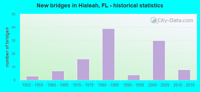
- New bridges - historical statistics
- 31950-1959
- 71960-1969
- 161970-1979
- 391980-1989
- 41990-1999
- 302000-2009
- 82010-2019
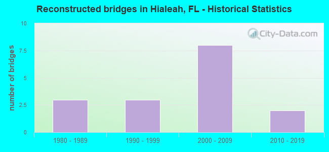
- Reconstructed bridges - Historical Statistics
- 31980-1989
- 31990-1999
- 82000-2009
- 22010-2019
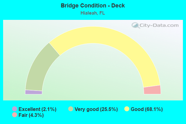
- Bridge Condition - Deck
- 2.1%Excellent
- 25.5%Very good
- 68.1%Good
- 4.3%Fair
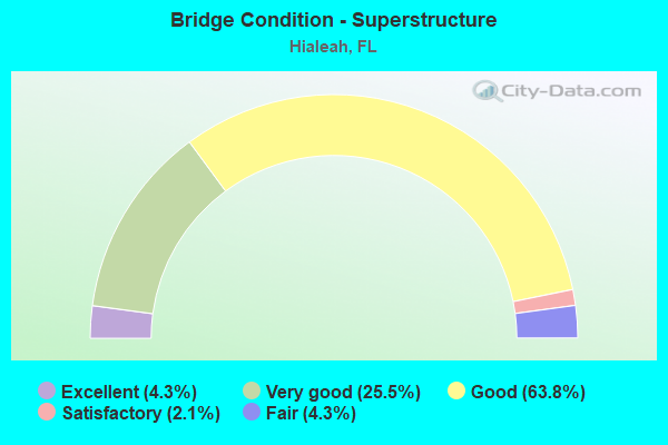
- Bridge Condition - Superstructure
- 4.3%Excellent
- 25.5%Very good
- 63.8%Good
- 2.1%Satisfactory
- 4.3%Fair
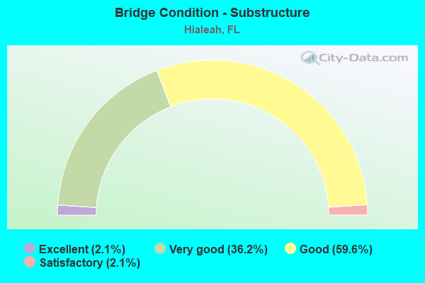
- Bridge Condition - Substructure
- 2.1%Excellent
- 36.2%Very good
- 59.6%Good
- 2.1%Satisfactory
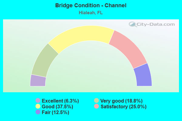
- Bridge Condition - Channel
- 6.3%Excellent
- 18.8%Very good
- 37.5%Good
- 25.0%Satisfactory
- 12.5%Fair
Find on map >> Show street view
Structure Number: 875801, Location: 1/4 mile N/O NW 103rd St (Lat: 25.870556, Lng: -80.283194), Route carried "on" structure: City street , Year Built: 1970, Year Reconstructed: 1998, Status: Open, Structure Length: 1.22m (4.00ft), Average Daily Traffic: 23,566 (year 2021), Truck Traffic: 5%, Average Future Daily Traffic: 40,887 (year 2042), Design Load: HS 20, Features Intersected: Little River Canal, Facility Carried by Structure: Palm Avenue
Minimum Vertical Clearance: 30+ m (98+ ft), Kilometerpoint: 1.225, Lanes on structure: 4, Owner: City or Municipal Highway Agency, Approaching Roadway Width: 16.5m (54.1ft), Material/Design: Prestressed concrete, Design/Construction: Slab, Number Of Spans In Main Unit: 2, Length of Maximum Span: 6.1m (20.0ft), Curb or Sidewalk Widths: Left: 1.9m (6.2ft), Right: 1.9m (6.2ft), Curb-To-Curb Width: 16.5m (54.1ft), Out-to-Out Width: 21.5m (70.5ft)
Condition: Deck: Good, Superstructure: Good, Substructure: Good, Channel: Fair, Operating Rating: 59.3 metric tons, Method Used To Determine Operating Rating: Load Factor (LF), Inventory Rating: 35.5 metric tons, Method Used To Determine Inventory Rating: Load Factor (LF), Structural Evaluation: Better than present minimum criteria, Deck Geometry: Meets minimum limits, Waterway Adequacy: Equal to present desirable criteria, Approach Roadway Alignment: Equal to present desirable criteria, Designated Inspection Frequency: Every 24 months, Underwater Inspection Frequency: Every 24 months, Inspection Date: June 2021, Underwater Inspection Date: June 2021, Deck Structure Type: Concrete Precast Panels, Wearing Surface/Protective System: Wearing Surface: Bituminous
Find on map >> Show street view
Structure Number: 875802, Location: 1/4 Mile N of NW 103rd St (Lat: 25.869611, Lng: -80.298861), Route carried "on" structure: City street , Year Built: 1970, Year Reconstructed: 2005, Status: Open, Structure Length: 2.57m (8.43ft), Average Daily Traffic: 11,740 (year 2013), Truck Traffic: 3%, Average Future Daily Traffic: 18,244 (year 2035), Design Load: HS 20, Features Intersected: Little River Canal, Facility Carried by Structure: West 8th Avenue
Minimum Vertical Clearance: 30+ m (98+ ft), Kilometerpoint: 1.199, Lanes on structure: 4, Owner: City or Municipal Highway Agency, Approaching Roadway Width: 17.5m (57.4ft), Material/Design: Prestressed concrete, Design/Construction: Slab, Number Of Spans In Main Unit: 3, Length of Maximum Span: 8.5m (27.9ft), Curb or Sidewalk Widths: Left: 1.8m (5.9ft), Right: 1.8m (5.9ft), Curb-To-Curb Width: 17.5m (57.4ft), Out-to-Out Width: 22.1m (72.5ft)
Condition: Deck: Good, Superstructure: Good, Substructure: Good, Channel: Good, Operating Rating: 64.2 metric tons, Method Used To Determine Operating Rating: Load Factor (LF), Inventory Rating: 38.6 metric tons, Method Used To Determine Inventory Rating: Load Factor (LF), Structural Evaluation: Better than present minimum criteria, Deck Geometry: Somewhat better than minimum adequacy, Waterway Adequacy: Better than present minimum criteria, Approach Roadway Alignment: Better than present minimum criteria, Designated Inspection Frequency: Every 24 months, Underwater Inspection Frequency: Every 24 months, Inspection Date: June 2021, Underwater Inspection Date: June 2021, Deck Structure Type: Concrete Precast Panels, Wearing Surface/Protective System: Wearing Surface: Bituminous
Find on map >> Show street view
Structure Number: 875803, Location: 0.2 miles N/O NW 103rd St (Lat: 25.869583, Lng: -80.314917), Route carried "on" structure: City street , Year Built: 1970, Status: Open, Structure Length: 2.72m (8.92ft), Average Daily Traffic: 16,891 (year 2013), Truck Traffic: 2%, Average Future Daily Traffic: 27,449 (year 2035), Design Load: HS 20, Features Intersected: Little River Canal, Facility Carried by Structure: West 16th Avenue
Minimum Vertical Clearance: 30+ m (98+ ft), Kilometerpoint: 0.327, Lanes on structure: 4, Owner: City or Municipal Highway Agency, Approaching Roadway Width: 17.7m (58.1ft), Skew: 1 degrees, Material/Design: Prestressed concrete, Design/Construction: Slab, Number Of Spans In Main Unit: 3, Length of Maximum Span: 8.7m (28.5ft), Curb or Sidewalk Widths: Left: 1.5m (4.9ft), Right: 1.5m (4.9ft), Curb-To-Curb Width: 18.3m (60.0ft), Out-to-Out Width: 22.1m (72.5ft)
Condition: Deck: Good, Superstructure: Good, Substructure: Good, Channel: Satisfactory, Operating Rating: 56.5 metric tons, Method Used To Determine Operating Rating: Load Factor (LF), Inventory Rating: 33.8 metric tons, Method Used To Determine Inventory Rating: Load Factor (LF), Structural Evaluation: Better than present minimum criteria, Deck Geometry: Somewhat better than minimum adequacy, Waterway Adequacy: Equal to present minimum criteria, Approach Roadway Alignment: Better than present minimum criteria, Designated Inspection Frequency: Every 24 months, Underwater Inspection Frequency: Every 24 months, Inspection Date: June 2021, Underwater Inspection Date: June 2021, Deck Structure Type: Concrete Precast Panels, Wearing Surface/Protective System: Wearing Surface: Bituminous
Find on map >> Show street view
Structure Number: 875804, Location: 100Ft. S of West 53rd St. (Lat: 25.870361, Lng: -80.291167), Route carried "on" structure: Business City street , Year Built: 1958, Status: Open, Structure Length: 2.26m (7.41ft), Average Daily Traffic: 4,286 (year 2020), Truck Traffic: 5%, Average Future Daily Traffic: 7,079 (year 2042), Design Load: HS 20, Features Intersected: Little River Canal, Facility Carried by Structure: W 4th Ave Frontage
Minimum Vertical Clearance: 30+ m (98+ ft), Kilometerpoint: 0.396, Lanes on structure: 2, Owner: City or Municipal Highway Agency, Approaching Roadway Width: 6.1m (20.0ft), Material/Design: Prestressed concrete, Design/Construction: Slab, Number Of Spans In Main Unit: 3, Length of Maximum Span: 9.1m (29.9ft), Curb or Sidewalk Widths: Left: 1.5m (4.9ft), Right: 0.0m, Curb-To-Curb Width: 7.3m (24.0ft), Out-to-Out Width: 9.8m (32.2ft)
Condition: Deck: Good, Superstructure: Good, Substructure: Good, Channel: Fair, Operating Rating: 45.3 metric tons, Method Used To Determine Operating Rating: Load Factor (LF), Inventory Rating: 27.9 metric tons, Method Used To Determine Inventory Rating: Load Factor (LF), Structural Evaluation: Better than present minimum criteria, Deck Geometry: High priority of replacement, Waterway Adequacy: Better than present minimum criteria, Approach Roadway Alignment: Equal to present desirable criteria, Designated Inspection Frequency: Every 24 months, Underwater Inspection Frequency: Every 24 months, Inspection Date: April 2020, Underwater Inspection Date: April 2020, Deck Structure Type: Concrete Precast Panels, Wearing Surface/Protective System: Wearing Surface: Bituminous
Find on map >> Show street view
Structure Number: 875805, Location: At East 53rd Street (Lat: 25.870528, Lng: -80.278889), Route carried "on" structure: City street , Year Built: 2005, Status: Open, Structure Length: 1.50m (4.92ft), Average Daily Traffic: 50 (year 2020), Average Future Daily Traffic: 15,000 (year 2042), Design Load: HS 20, Features Intersected: Canal C-7, Facility Carried by Structure: East 2nd Avenue
Minimum Vertical Clearance: 30+ m (98+ ft), Kilometerpoint: 0.377, Lanes on structure: 2, Owner: City or Municipal Highway Agency, Approaching Roadway Width: 7.4m (24.3ft), Skew: 2 degrees, Material/Design: Prestressed concrete, Design/Construction: Tee Beam, Number Of Spans In Main Unit: 1, Length of Maximum Span: 15.0m (49.2ft), Curb or Sidewalk Widths: Left: 2.0m (6.6ft), Right: 2.0m (6.6ft), Curb-To-Curb Width: 8.2m (26.9ft), Out-to-Out Width: 13.0m (42.7ft)
Condition: Deck: Very good, Superstructure: Very good, Substructure: Very good, Channel: Very good, Inventory Rating: 66.7 metric tons, Method Used To Determine Inventory Rating: Load Factor (LF), Structural Evaluation: Equal to present desirable criteria, Deck Geometry: Equal to present minimum criteria, Waterway Adequacy: Equal to present desirable criteria, Approach Roadway Alignment: Equal to present desirable criteria, Designated Inspection Frequency: Every 24 months, Underwater Inspection Frequency: Every 24 months, Inspection Date: November 2020, Underwater Inspection Date: November 2020, Deck Structure Type: Concrete Cast-file-Place
Find on map >> Show street view
Structure Number: 870026, Location: At US 27/SR 953 Off Ramps (Lat: 25.809722, Lng: -80.258375), Route carried "under" structure: City street 37, Year Built: 1961, Structure Length: 0. m, Average Daily Traffic: 500 (year 2021), Truck Traffic: 2%, Features Intersected: R/R & NW 37th Place, Facility Carried by Structure: SR 112 WB
Minimum Vertical Clearance: 7.50m (24.61ft), Kilometerpoint: 2.055, Lanes on structure: 4, Lanes under structure: 2, Material/Design: Steel, Design/Construction: Stringer/Multi-beam, Length of Maximum Span: 20.1m (65.9ft)
Find on map >> Show street view
Structure Number: 870467, Location: I-75/SR-826 INTERCHANGE (Lat: 25.898608, Lng: -80.324303), Route carried "under" structure: Ramp Interstate 75, Year Built: 1974, Structure Length: 0. m, Average Daily Traffic: 9,700 (year 2020), Truck Traffic: 9%, Features Intersected: I-75 RAMP & NW 138 ST, Facility Carried by Structure: SR-826
Minimum Vertical Clearance: 4.88m (16.01ft), Kilometerpoint: 0.000, Lanes on structure: 7, Lanes under structure: 1, Material/Design: Prestressed concrete, Design/Construction: Stringer/Multi-beam, Length of Maximum Span: 25.3m (83.0ft)
Find on map >> Show street view
Structure Number: 870467, Location: I-75/SR-826 INTERCHANGE (Lat: 25.898608, Lng: -80.324303), Route carried "under" structure: City street 916, Year Built: 1974, Structure Length: 0. m, Average Daily Traffic: 16,300 (year 2020), Truck Traffic: 4%, Features Intersected: I-75 RAMP & NW 138 ST, Facility Carried by Structure: SR-826
Minimum Vertical Clearance: 4.88m (16.01ft), Kilometerpoint: 0.000, Lanes on structure: 7, Lanes under structure: 2, Material/Design: Prestressed concrete, Design/Construction: Stringer/Multi-beam, Length of Maximum Span: 25.3m (83.0ft)
Find on map >> Show street view
Structure Number: 870596, Location: 0.75 MI S OF SR-860 (Lat: 25.927931, Lng: -80.350389), Route carried "under" structure: Interstate 75, Year Built: 1984, Structure Length: 0. m, Average Daily Traffic: 140,000 (year 2020), Truck Traffic: 8%, Features Intersected: I-75, Facility Carried by Structure: NW 170 ST
Minimum Vertical Clearance: 5.15m (16.90ft), Kilometerpoint: 5.596, Lanes on structure: 2, Lanes under structure: 8, Material/Design: Prestressed concrete, Design/Construction: Stringer/Multi-beam, Length of Maximum Span: 34.4m (112.9ft)
Find on map >> Show street view
Structure Number: 8706, Location: 1 MI W OF PALMETTO EXPWY (Lat: 25.898222, Lng: -80.340250), Route carried "under" structure: Interstate 75, Year Built: 1984, Structure Length: 0. m, Average Daily Traffic: 130,000 (year 2020), Truck Traffic: 8%, Features Intersected: I-75 (SR-93), Facility Carried by Structure: NW 87TH AVE NB
Minimum Vertical Clearance: 5.12m (16.80ft), Kilometerpoint: 1.696, Lanes on structure: 2, Lanes under structure: 10, Material/Design: Steel continuous, Design/Construction: Stringer/Multi-beam, Length of Maximum Span: 49.1m (161.1ft)
Find on map >> Show street view
Structure Number: 8706, Location: 1 MI W OF PALMETTO EXPWY (Lat: 25.898222, Lng: -80.340250), Route carried "under" structure: Interstate 75, Year Built: 1984, Structure Length: 0. m, Average Daily Traffic: 4,900 (year 2020), Truck Traffic: 12%, Features Intersected: I-75 (SR-93), Facility Carried by Structure: NW 87TH AVE NB
Minimum Vertical Clearance: 4.85m (15.91ft), Kilometerpoint: 7.131, Lanes on structure: 2, Lanes under structure: 1, Toll: On toll road, Material/Design: Steel continuous, Design/Construction: Stringer/Multi-beam, Length of Maximum Span: 49.1m (161.1ft)
Find on map >> Show street view
Structure Number: 8706, Location: 1 MI W OF PALMETTO EXPWY (Lat: 25.898222, Lng: -80.340250), Route carried "under" structure: Interstate 75, Year Built: 1984, Structure Length: 0. m, Average Daily Traffic: 4,900 (year 2020), Truck Traffic: 12%, Features Intersected: I-75 (SR-93), Facility Carried by Structure: NW 87TH AVE NB
Minimum Vertical Clearance: 5.12m (16.80ft), Kilometerpoint: 2.165, Lanes on structure: 2, Lanes under structure: 1, Toll: On toll road, Material/Design: Steel continuous, Design/Construction: Stringer/Multi-beam, Length of Maximum Span: 49.1m (161.1ft)
Find on map >> Show street view
Structure Number: 870605, Location: 1.7MI W OF PALMETTO EXPWY (Lat: 25.902333, Lng: -80.349111), Route carried "under" structure: ServiceInterstate 75, Year Built: 1985, Structure Length: 0. m, Average Daily Traffic: 4,900 (year 2020), Truck Traffic: 12%, Features Intersected: I-75/I-75 EXPRESS LANES, Facility Carried by Structure: NW 92ND AVE. RAMP
Minimum Vertical Clearance: 6.74m (22.11ft), Kilometerpoint: 3.267, Lanes on structure: 2, Lanes under structure: 1, Toll: On toll road, Material/Design: Steel continuous, Design/Construction: Stringer/Multi-beam, Length of Maximum Span: 48.6m (159.4ft)
Find on map >> Show street view
Structure Number: 870605, Location: 1.7MI W OF PALMETTO EXPWY (Lat: 25.902333, Lng: -80.349111), Route carried "under" structure: Interstate 75, Year Built: 1985, Structure Length: 0. m, Average Daily Traffic: 140,000 (year 2020), Truck Traffic: 8%, Features Intersected: I-75/I-75 EXPRESS LANES, Facility Carried by Structure: NW 92ND AVE. RAMP
Minimum Vertical Clearance: 5.03m (16.50ft), Kilometerpoint: 2.778, Lanes on structure: 2, Lanes under structure: 8, Material/Design: Steel continuous, Design/Construction: Stringer/Multi-beam, Length of Maximum Span: 48.6m (159.4ft)
Find on map >> Show street view
Structure Number: 870605, Location: 1.7MI W OF PALMETTO EXPWY (Lat: 25.902333, Lng: -80.349111), Route carried "under" structure: ServiceInterstate 75, Year Built: 1985, Structure Length: 0. m, Average Daily Traffic: 5,500 (year 2019), Truck Traffic: 11%, Features Intersected: I-75/I-75 EXPRESS LANES, Facility Carried by Structure: NW 92ND AVE. RAMP
Minimum Vertical Clearance: 6.10m (20.01ft), Kilometerpoint: 4.783, Lanes on structure: 2, Lanes under structure: 1, Toll: On toll road, Material/Design: Steel continuous, Design/Construction: Stringer/Multi-beam, Length of Maximum Span: 48.6m (159.4ft)
Find on map >> Show street view
Structure Number: 870643, Location: I-75/SR 826 INTERCHANGE (Lat: 25.895778, Lng: -80.324528), Route carried "under" structure: State highway 826, Year Built: 1986, Structure Length: 0. m, Average Daily Traffic: 182,000 (year 2020), Truck Traffic: 9%, Features Intersected: SR-826 & I-75, Facility Carried by Structure: RAMP TO I-75 NB
Minimum Vertical Clearance: 6.07m (19.91ft), Kilometerpoint: 24.293, Lanes on structure: 2, Lanes under structure: 8, Toll: Toll bridge, Material/Design: Prestressed concrete continuous, Design/Construction: Segmental Box Girder, Length of Maximum Span: 66.1m (216.9ft)
Find on map >> Show street view
Structure Number: 870643, Location: I-75/SR 826 INTERCHANGE (Lat: 25.895778, Lng: -80.324528), Route carried "under" structure: Ramp State highway 826, Year Built: 1986, Structure Length: 0. m, Average Daily Traffic: 4,900 (year 2020), Truck Traffic: 12%, Features Intersected: SR-826 & I-75, Facility Carried by Structure: RAMP TO I-75 NB
Minimum Vertical Clearance: 4.97m (16.31ft), Kilometerpoint: 1.609, Lanes on structure: 2, Lanes under structure: 1, Material/Design: Prestressed concrete continuous, Design/Construction: Segmental Box Girder, Length of Maximum Span: 66.1m (216.9ft)
Find on map >> Show street view
Structure Number: 870643, Location: I-75/SR 826 INTERCHANGE (Lat: 25.895778, Lng: -80.324528), Route carried "under" structure: City street 138, Year Built: 1986, Structure Length: 0. m, Average Daily Traffic: 15,000 (year 2020), Truck Traffic: 5%, Features Intersected: SR-826 & I-75, Facility Carried by Structure: RAMP TO I-75 NB
Minimum Vertical Clearance: 10.52m (34.51ft), Kilometerpoint: 1.609, Lanes on structure: 2, Lanes under structure: 2, Material/Design: Prestressed concrete continuous, Design/Construction: Segmental Box Girder, Length of Maximum Span: 66.1m (216.9ft)
Find on map >> Show street view
Structure Number: 870643, Location: I-75/SR 826 INTERCHANGE (Lat: 25.895778, Lng: -80.324528), Route carried "under" structure: Ramp Interstate 75, Year Built: 1986, Structure Length: 0. m, Average Daily Traffic: 4,900 (year 2020), Truck Traffic: 12%, Features Intersected: SR-826 & I-75
Minimum Vertical Clearance: 5.00m (16.40ft), Kilometerpoint: 1.173, Lanes on structure: 2, Lanes under structure: 4, Material/Design: Prestressed concrete continuous, Design/Construction: Segmental Box Girder, Length of Maximum Span: 66.1m (216.9ft)
Find on map >> Show street view
Structure Number: 870643, Location: I-75/SR 826 INTERCHANGE (Lat: 25.895778, Lng: -80.324528), Route carried "under" structure: Ramp Interstate 75, Year Built: 1986, Structure Length: 0. m, Average Daily Traffic: 4,900 (year 2020), Truck Traffic: 12%, Features Intersected: SR-826 & I-75
Minimum Vertical Clearance: 5.31m (17.42ft), Kilometerpoint: 8.557, Lanes on structure: 2, Lanes under structure: 2, Material/Design: Prestressed concrete continuous, Design/Construction: Segmental Box Girder, Length of Maximum Span: 66.1m (216.9ft)
Find on map >> Show street view
Structure Number: 870643, Location: I-75/SR 826 INTERCHANGE (Lat: 25.895778, Lng: -80.324528), Route carried "under" structure: Ramp Interstate 75, Year Built: 1986, Structure Length: 0. m, Average Daily Traffic: 4,900 (year 2020), Truck Traffic: 12%, Features Intersected: SR-826 & I-75
Minimum Vertical Clearance: 5.98m (19.62ft), Kilometerpoint: 9.571, Lanes on structure: 2, Lanes under structure: 2, Material/Design: Prestressed concrete continuous, Design/Construction: Segmental Box Girder, Length of Maximum Span: 66.1m (216.9ft)
Find on map >> Show street view
Structure Number: 870644, Location: I-75/SR 826 INTERCHANGE (Lat: 25.900194, Lng: -80.326250), Route carried "under" structure: State highway 826, Year Built: 1986, Structure Length: 0. m, Average Daily Traffic: 135,500 (year 2020), Truck Traffic: 6%, Features Intersected: SR-826
Minimum Vertical Clearance: 6.98m (22.90ft), Kilometerpoint: 24.914, Lanes on structure: 1, Lanes under structure: 8, Toll: On toll road, Material/Design: Prestressed concrete continuous, Design/Construction: Segmental Box Girder, Length of Maximum Span: 58.5m (191.9ft)
Find on map >> Show street view
Structure Number: 870644, Location: I-75/SR 826 INTERCHANGE (Lat: 25.900194, Lng: -80.326250), Route carried "under" structure: Interstate 75, Year Built: 1986, Structure Length: 0. m, Average Daily Traffic: 65,000 (year 2020), Truck Traffic: 8%, Features Intersected: SR-826, Facility Carried by Structure: SR924WB TO SR826SB
Minimum Vertical Clearance: 5.09m (16.70ft), Kilometerpoint: 0.325, Lanes on structure: 1, Lanes under structure: 3, Material/Design: Prestressed concrete continuous, Design/Construction: Segmental Box Girder, Length of Maximum Span: 58.5m (191.9ft)
Find on map >> Show street view
Structure Number: 870644, Location: I-75/SR 826 INTERCHANGE (Lat: 25.900194, Lng: -80.326250), Route carried "under" structure: Ramp Interstate 75, Year Built: 1986, Structure Length: 0. m, Average Daily Traffic: 9,700 (year 2020), Truck Traffic: 9%, Features Intersected: SR-826, Facility Carried by Structure: SR924WB TO SR826SB
Minimum Vertical Clearance: 10.30m (33.79ft), Kilometerpoint: 0.322, Lanes on structure: 1, Lanes under structure: 1, Material/Design: Prestressed concrete continuous, Design/Construction: Segmental Box Girder, Length of Maximum Span: 58.5m (191.9ft)
Find on map >> Show street view
Structure Number: 870644, Location: I-75/SR 826 INTERCHANGE (Lat: 25.900194, Lng: -80.326250), Route carried "under" structure: City street 138, Year Built: 1986, Structure Length: 0. m, Average Daily Traffic: 15,000 (year 2020), Truck Traffic: 5%, Features Intersected: SR-826, Facility Carried by Structure: SR924WB TO SR826SB
Minimum Vertical Clearance: 13.29m (43.60ft), Kilometerpoint: 0.000, Lanes on structure: 1, Lanes under structure: 2, Material/Design: Prestressed concrete continuous, Design/Construction: Segmental Box Girder, Length of Maximum Span: 58.5m (191.9ft)
Find on map >> Show street view
Structure Number: 870645, Location: I-75/SR-826 INTERCHANGE (Lat: 25.898728, Lng: -80.327017), Route carried "under" structure: State highway , Year Built: 1986, Structure Length: 0. m, Average Daily Traffic: 15,000 (year 2016), Truck Traffic: 10%, Features Intersected: I-75 W-N CONN & NW138 ST, Facility Carried by Structure: SR826 SB TO I-75SB
Minimum Vertical Clearance: 8.60m (28.22ft), Kilometerpoint: 0.000, Lanes on structure: 1, Lanes under structure: 2, Material/Design: Prestressed concrete continuous, Design/Construction: Segmental Box Girder, Length of Maximum Span: 42.1m (138.1ft)
Find on map >> Show street view
Structure Number: 870645, Location: I-75/SR-826 INTERCHANGE (Lat: 25.898728, Lng: -80.327017), Route carried "under" structure: Ramp Interstate 75, Year Built: 1986, Structure Length: 0. m, Average Daily Traffic: 49,500 (year 2016), Truck Traffic: 5%, Features Intersected: I-75 W-N CONN & NW138 ST
Minimum Vertical Clearance: 4.94m (16.21ft), Kilometerpoint: 0.000, Lanes on structure: 1, Lanes under structure: 1, Material/Design: Prestressed concrete continuous, Design/Construction: Segmental Box Girder, Length of Maximum Span: 42.1m (138.1ft)
Find on map >> Show street view
Structure Number: 870646, Location: I-75/SR-826 INTERCHANGE (Lat: 25.900278, Lng: -80.324167), Route carried "under" structure: State highway 826, Year Built: 1986, Structure Length: 0. m, Average Daily Traffic: 135,500 (year 2020), Truck Traffic: 6%, Features Intersected: SR-826, Facility Carried by Structure: I-75 SB
Minimum Vertical Clearance: 4.97m (16.31ft), Kilometerpoint: 24.922, Lanes on structure: 4, Lanes under structure: 7, Toll: On toll road, Material/Design: Prestressed concrete continuous, Design/Construction: Segmental Box Girder, Length of Maximum Span: 53.0m (173.9ft)
Find on map >> Show street view
Structure Number: 870647, Location: I-75/SR 826 INTERCHANGE (Lat: 25.900889, Lng: -80.324389), Route carried "under" structure: State highway 826, Year Built: 1986, Structure Length: 0. m, Average Daily Traffic: 135,500 (year 2020), Truck Traffic: 6%, Features Intersected: SR-826, Facility Carried by Structure: I-75 NB
Minimum Vertical Clearance: 4.97m (16.31ft), Kilometerpoint: 25.004, Lanes on structure: 3, Lanes under structure: 8, Toll: On toll road, Material/Design: Prestressed concrete continuous, Design/Construction: Segmental Box Girder, Length of Maximum Span: 53.0m (173.9ft)
Find on map >> Show street view
Structure Number: 870648, Location: I-75/SR 826 INTERCHANGE (Lat: 25.897636, Lng: -80.329536), Route carried "under" structure: City street 138, Year Built: 1986, Structure Length: 0. m, Average Daily Traffic: 15,000 (year 2014), Truck Traffic: 5%, Features Intersected: NW 138TH ST, Facility Carried by Structure: I-75 SB TO SR826SB
Minimum Vertical Clearance: 4.81m (15.78ft), Kilometerpoint: 0.087, Lanes on structure: 2, Lanes under structure: 2, Material/Design: Prestressed concrete, Design/Construction: Stringer/Multi-beam, Length of Maximum Span: 21.0m (68.9ft)
Find on map >> Show street view
Structure Number: 870649, Location: 800 ft. East of SR 826 (Lat: 25.899861, Lng: -80.322222), Route carried "under" structure: Ramp State highway , Year Built: 1986, Structure Length: 0. m, Average Daily Traffic: 10,000 (year 2020), Truck Traffic: 7%, Features Intersected: I-75 Ramp to SR 826 NB, Facility Carried by Structure: SR 924 EB
Minimum Vertical Clearance: 7.62m (25.00ft), Kilometerpoint: 0.000, Lanes on structure: 4, Lanes under structure: 2, Material/Design: Prestressed concrete, Design/Construction: Stringer/Multi-beam, Length of Maximum Span: 24.7m (81.0ft)
Find on map >> Show street view
Structure Number: 87065, Location: 800 ft. East of SR 826 (Lat: 25.900097, Lng: -80.321639), Route carried "under" structure: Ramp State highway , Year Built: 1986, Structure Length: 0. m, Average Daily Traffic: 10,000 (year 2020), Truck Traffic: 7%, Features Intersected: I-75 Ramp to NB SR 826, Facility Carried by Structure: SR 924 WB
Minimum Vertical Clearance: 5.03m (16.50ft), Kilometerpoint: 0.000, Lanes on structure: 4, Lanes under structure: 2, Material/Design: Prestressed concrete, Design/Construction: Stringer/Multi-beam, Length of Maximum Span: 24.7m (81.0ft)
Find on map >> Show street view
Structure Number: 870708, Location: 1.0 mile East of SR 826 (Lat: 25.898653, Lng: -80.307722), Route carried "under" structure: State highway 916, Year Built: 1989, Structure Length: 0. m, Average Daily Traffic: 16,300 (year 2020), Truck Traffic: 4%, Features Intersected: SR 916 and NW 67th Ave, Facility Carried by Structure: SR 924 GRATIGNY
Minimum Vertical Clearance: 5.18m (16.99ft), Kilometerpoint: 1.748, Lanes on structure: 6, Lanes under structure: 4, Material/Design: Prestressed concrete, Design/Construction: Stringer/Multi-beam, Length of Maximum Span: 40.7m (133.5ft)
Find on map >> Show street view
Structure Number: 870708, Location: 1.0 mile East of SR 826 (Lat: 25.898653, Lng: -80.307722), Route carried "under" structure: City street , Year Built: 1989, Structure Length: 0. m, Average Daily Traffic: 39,144 (year 2020), Truck Traffic: 8%, Features Intersected: SR 916 and NW 67th Ave, Facility Carried by Structure: SR 924 GRATIGNY
Minimum Vertical Clearance: 4.97m (16.31ft), Kilometerpoint: 1.600, Lanes on structure: 6, Lanes under structure: 5, Material/Design: Prestressed concrete, Design/Construction: Stringer/Multi-beam, Length of Maximum Span: 40.7m (133.5ft)
Find on map >> Show street view
Structure Number: 870714, Location: NW 69 AVE (Lat: 25.840033, Lng: -80.309989), Route carried "under" structure: Alternate US 934, Year Built: 1972, Structure Length: 0. m, Average Daily Traffic: 13,520 (year 2010), Truck Traffic: 5%, Features Intersected: NW 69 AVE & FEC R/R
Minimum Vertical Clearance: 7.01m (23.00ft), Kilometerpoint: 51.353, Lanes on structure: 3, Lanes under structure: 2, Material/Design: Prestressed concrete, Design/Construction: Stringer/Multi-beam, Length of Maximum Span: 15.8m (51.8ft)
Find on map >> Show street view
Structure Number: 870717, Location: NW 69 AVE (Lat: 25.839889, Lng: -80.309950), Route carried "under" structure: Business City street 934, Year Built: 1972, Structure Length: 0. m, Average Daily Traffic: 14,230 (year 2002), Truck Traffic: 5%, Features Intersected: NW 69 AVE & FEC R/R, Facility Carried by Structure: NW 74 ST EB
Minimum Vertical Clearance: 7.01m (23.00ft), Kilometerpoint: 51.353, Lanes on structure: 3, Lanes under structure: 2, Material/Design: Prestressed concrete, Design/Construction: Stringer/Multi-beam, Length of Maximum Span: 15.8m (51.8ft)
Find on map >> Show street view
Structure Number: 87072, Location: 0.5 miles West of SR 823 (Lat: 25.897083, Lng: -80.300111), Route carried "under" structure: City street , Year Built: 1990, Structure Length: 0. m, Average Daily Traffic: 4,000 (year 2020), Truck Traffic: 5%, Features Intersected: W 8th Avenue, Facility Carried by Structure: SR 924 (Gratigny)
Minimum Vertical Clearance: 5.21m (17.09ft), Kilometerpoint: 0.000, Lanes on structure: 6, Lanes under structure: 4, Material/Design: Prestressed concrete, Design/Construction: Stringer/Multi-beam, Length of Maximum Span: 26.2m (86.0ft)
Find on map >> Show street view
Structure Number: 870757, Location: AT NW 103RD ST (Lat: 25.866689, Lng: -80.323017), Route carried "under" structure: State highway 932, Year Built: 2002, Structure Length: 0. m, Average Daily Traffic: 14,800 (year 2021), Truck Traffic: 6%, Features Intersected: SR-932 (NW 103RD ST), Facility Carried by Structure: SR-826 SB (870995)
Minimum Vertical Clearance: 5.30m (17.39ft), Kilometerpoint: 1.827, Lanes on structure: 5, Lanes under structure: 9, Material/Design: Prestressed concrete, Design/Construction: Stringer/Multi-beam, Length of Maximum Span: 43.9m (144.0ft)
Find on map >> Show street view
Structure Number: 870766, Location: 1MI S OF I-75 (Lat: 25.884042, Lng: -80.323639), Route carried "under" structure: City street , Year Built: 1997, Structure Length: 0. m, Average Daily Traffic: 34,500 (year 2018), Truck Traffic: 7%, Features Intersected: NW 122 ST (W 68 ST), Facility Carried by Structure: SR-826
Minimum Vertical Clearance: 5.18m (16.99ft), Kilometerpoint: 1.587, Lanes on structure: 12, Lanes under structure: 9, Material/Design: Steel, Design/Construction: Stringer/Multi-beam, Length of Maximum Span: 47.5m (155.8ft)
Find on map >> Show street view
Structure Number: 870856, Location: SR-826 at NW 103rd St. (Lat: 25.867742, Lng: -80.322694), Route carried "under" structure: State highway 826, Year Built: 2002, Structure Length: 0. m, Average Daily Traffic: 182,000 (year 2020), Truck Traffic: 6%, Features Intersected: SR-826 & NW 103rd St., Facility Carried by Structure: Ramp D Flyover
Minimum Vertical Clearance: 5.06m (16.60ft), Kilometerpoint: 21.327, Lanes on structure: 2, Lanes under structure: 8, Material/Design: Steel continuous, Design/Construction: Stringer/Multi-beam, Length of Maximum Span: 55.4m (181.8ft)
Find on map >> Show street view
Structure Number: 870856, Location: SR-826 at NW 103rd St. (Lat: 25.867742, Lng: -80.322694), Route carried "under" structure: City street , Year Built: 2002, Structure Length: 0. m, Average Daily Traffic: 9,899 (year 2020), Truck Traffic: 6%, Features Intersected: SR-826 & NW 103rd St., Facility Carried by Structure: Ramp D Flyover
Minimum Vertical Clearance: 11.52m (37.80ft), Kilometerpoint: 0.119, Lanes on structure: 2, Lanes under structure: 2, Material/Design: Steel continuous, Design/Construction: Stringer/Multi-beam, Length of Maximum Span: 55.4m (181.8ft)
Find on map >> Show street view
Structure Number: 870856, Location: SR-826 at NW 103rd St. (Lat: 25.867742, Lng: -80.322694), Route carried "under" structure: Ramp State highway 826, Year Built: 2002, Structure Length: 0. m, Average Daily Traffic: 16,500 (year 2019), Truck Traffic: 6%, Features Intersected: SR-826 & NW 103rd St., Facility Carried by Structure: Ramp D Flyover
Minimum Vertical Clearance: 8.50m (27.89ft), Kilometerpoint: 0.290, Lanes on structure: 2, Lanes under structure: 3, Material/Design: Steel continuous, Design/Construction: Stringer/Multi-beam, Length of Maximum Span: 55.4m (181.8ft)
Find on map >> Show street view
Structure Number: 870856, Location: SR-826 at NW 103rd St. (Lat: 25.867742, Lng: -80.322694), Route carried "under" structure: State highway 932, Year Built: 2002, Structure Length: 0. m, Average Daily Traffic: 14,800 (year 2020), Truck Traffic: 6%, Features Intersected: SR-826 & NW 103rd St., Facility Carried by Structure: Ramp D Flyover
Minimum Vertical Clearance: 8.41m (27.59ft), Kilometerpoint: 1.811, Lanes on structure: 2, Lanes under structure: 7, Material/Design: Steel continuous, Design/Construction: Stringer/Multi-beam, Length of Maximum Span: 55.4m (181.8ft)
Find on map >> Show street view
Structure Number: 870957, Location: 0.5MI. S OF W 68TH ST. (Lat: 25.877000, Lng: -80.323333), Route carried "under" structure: City street , Year Built: 2002, Structure Length: 0. m, Average Daily Traffic: 10,000 (year 2016), Truck Traffic: 5%, Features Intersected: W 60TH ST (NW 114TH ST), Facility Carried by Structure: SR-826 (PALMETTO)
Minimum Vertical Clearance: 5.18m (16.99ft), Kilometerpoint: 0.000, Lanes on structure: 13, Lanes under structure: 5, Material/Design: Prestressed concrete, Design/Construction: Stringer/Multi-beam, Length of Maximum Span: 32.3m (106.0ft)
Find on map >> Show street view
Structure Number: 870977, Location: 0.8MI S OF SR-932 (Lat: 25.855503, Lng: -80.323261), Route carried "under" structure: City street , Year Built: 2007, Structure Length: 0. m, Average Daily Traffic: 8,400 (year 2021), Truck Traffic: 10%, Features Intersected: US27, SR-826& S RIVER DR, Facility Carried by Structure: US27 TO SR-826 SB
Minimum Vertical Clearance: 5.12m (16.80ft), Kilometerpoint: 0.000, Lanes on structure: 1, Lanes under structure: 4, Material/Design: Steel continuous, Design/Construction: Stringer/Multi-beam, Length of Maximum Span: 64.0m (210.0ft)
Find on map >> Show street view
Structure Number: 870977, Location: 0.8MI S OF SR-932 (Lat: 25.855503, Lng: -80.323261), Route carried "under" structure: State highway 826, Year Built: 2007, Structure Length: 0. m, Average Daily Traffic: 209,000 (year 2021), Truck Traffic: 6%, Features Intersected: US27, SR-826& S RIVER DR
Minimum Vertical Clearance: 5.06m (16.60ft), Kilometerpoint: 19.951, Lanes on structure: 1, Lanes under structure: 13, Material/Design: Steel continuous, Design/Construction: Stringer/Multi-beam, Length of Maximum Span: 64.0m (210.0ft)
Find on map >> Show street view
Structure Number: 870977, Location: 0.8MI S OF SR-932 (Lat: 25.855503, Lng: -80.323261), Route carried "under" structure: US 27, Year Built: 2007, Structure Length: 0. m, Average Daily Traffic: 51,500 (year 2021), Truck Traffic: 14%, Features Intersected: US27, SR-826& S RIVER DR
Minimum Vertical Clearance: 6.28m (20.60ft), Kilometerpoint: 16.349, Lanes on structure: 1, Lanes under structure: 6, Material/Design: Steel continuous, Design/Construction: Stringer/Multi-beam, Length of Maximum Span: 64.0m (210.0ft)
Find on map >> Show street view
Structure Number: 870977, Location: 0.8MI S OF SR-932 (Lat: 25.855503, Lng: -80.323261), Route carried "under" structure: Ramp State highway 826, Year Built: 2007, Structure Length: 0. m, Average Daily Traffic: 14,500 (year 2021), Truck Traffic: 12%, Features Intersected: US27, SR-826& S RIVER DR
Minimum Vertical Clearance: 5.06m (16.60ft), Kilometerpoint: 0.283, Lanes on structure: 1, Lanes under structure: 1, Material/Design: Steel continuous, Design/Construction: Stringer/Multi-beam, Length of Maximum Span: 64.0m (210.0ft)
Find on map >> Show street view
Structure Number: 870988, Location: NW 74st over OKEECHOBE (Lat: 25.840589, Lng: -80.304889), Route carried "under" structure: State highway 25, Year Built: 2005, Structure Length: 0. m, Average Daily Traffic: 55,000 (year 2005), Truck Traffic: 6%, Features Intersected: MIA Canal/Okeechobee RD, Facility Carried by Structure: SR 934 WB (870989)
Minimum Vertical Clearance: 5.67m (18.60ft), Kilometerpoint: 51.853, Lanes on structure: 3, Lanes under structure: 6, Material/Design: Steel, Design/Construction: Stringer/Multi-beam, Length of Maximum Span: 56.5m (185.4ft)
Find on map >> Show street view
Structure Number: 870988, Location: NW 74st over OKEECHOBE (Lat: 25.840589, Lng: -80.304889), Route carried "under" structure: Alternate City street , Year Built: 2005, Structure Length: 0. m, Average Daily Traffic: 3,800 (year 2007), Features Intersected: MIA Canal/Okeechobee RD, Facility Carried by Structure: SR 934 WB (870989)
Minimum Vertical Clearance: 5.20m (17.06ft), Kilometerpoint: 51.853, Lanes on structure: 3, Lanes under structure: 2, Material/Design: Steel, Design/Construction: Stringer/Multi-beam, Length of Maximum Span: 56.5m (185.4ft)
Find on map >> Show street view
Structure Number: 870989, Location: NW 74 st. over Okeechobee (Lat: 25.840489, Lng: -80.304689), Route carried "under" structure: State highway 25, Year Built: 2005, Structure Length: 0. m, Average Daily Traffic: 55,000 (year 2005), Truck Traffic: 6%, Features Intersected: Mia Canal/Okeechobee RD, Facility Carried by Structure: SR 934 EB (870988)
Minimum Vertical Clearance: 5.67m (18.60ft), Kilometerpoint: 51.853, Lanes on structure: 3, Lanes under structure: 6, Material/Design: Steel, Design/Construction: Stringer/Multi-beam, Length of Maximum Span: 56.5m (185.4ft)
Find on map >> Show street view
Structure Number: 870989, Location: NW 74 st. over Okeechobee (Lat: 25.840489, Lng: -80.304689), Route carried "under" structure: Alternate City street , Year Built: 2005, Structure Length: 0. m, Average Daily Traffic: 3,800 (year 2007), Features Intersected: Mia Canal/Okeechobee RD, Facility Carried by Structure: SR 934 EB (870988)
Minimum Vertical Clearance: 5.76m (18.90ft), Kilometerpoint: 51.853, Lanes on structure: 3, Lanes under structure: 2, Material/Design: Steel, Design/Construction: Stringer/Multi-beam, Length of Maximum Span: 56.5m (185.4ft)
Find on map >> Show street view
Structure Number: 870995, Location: AT NW 103RD ST (Lat: 25.866711, Lng: -80.322825), Route carried "under" structure: State highway 932, Year Built: 2003, Structure Length: 0. m, Average Daily Traffic: 14,800 (year 2021), Truck Traffic: 6%, Features Intersected: SR-932 NW 103RD ST, Facility Carried by Structure: SR-826 NB (870757)
Minimum Vertical Clearance: 5.30m (17.39ft), Kilometerpoint: 1.852, Lanes on structure: 5, Lanes under structure: 9, Material/Design: Prestressed concrete, Design/Construction: Stringer/Multi-beam, Length of Maximum Span: 43.9m (144.0ft)
Find on map >> Show street view
Structure Number: 871001, Location: 1MI W OF SR-826(PALMETTO) (Lat: 25.898222, Lng: -80.340444), Route carried "under" structure: Interstate 75, Year Built: 2004, Structure Length: 0. m, Average Daily Traffic: 130,000 (year 2020), Truck Traffic: 8%, Features Intersected: I-75, Facility Carried by Structure: NW 87TH AVE SB
Minimum Vertical Clearance: 5.12m (16.80ft), Kilometerpoint: 1.717, Lanes on structure: 2, Lanes under structure: 10, Material/Design: Steel continuous, Design/Construction: Stringer/Multi-beam, Length of Maximum Span: 48.8m (160.1ft)
Find on map >> Show street view
Structure Number: 871001, Location: 1MI W OF SR-826(PALMETTO) (Lat: 25.898222, Lng: -80.340444), Route carried "under" structure: Interstate 75, Year Built: 2004, Structure Length: 0. m, Average Daily Traffic: 4,900 (year 2020), Truck Traffic: 12%, Features Intersected: I-75, Facility Carried by Structure: NW 87TH AVE SB
Minimum Vertical Clearance: 5.12m (16.80ft), Kilometerpoint: 2.187, Lanes on structure: 2, Lanes under structure: 1, Toll: On toll road, Material/Design: Steel continuous, Design/Construction: Stringer/Multi-beam, Length of Maximum Span: 48.8m (160.1ft)
Find on map >> Show street view
Structure Number: 871001, Location: 1MI W OF SR-826(PALMETTO) (Lat: 25.898222, Lng: -80.340444), Route carried "under" structure: Interstate 75, Year Built: 2004, Structure Length: 0. m, Average Daily Traffic: 4,900 (year 2020), Truck Traffic: 12%, Features Intersected: I-75, Facility Carried by Structure: NW 87TH AVE SB
Minimum Vertical Clearance: 4.85m (15.91ft), Kilometerpoint: 7.110, Lanes on structure: 2, Lanes under structure: 1, Toll: On toll road, Material/Design: Steel continuous, Design/Construction: Stringer/Multi-beam, Length of Maximum Span: 48.8m (160.1ft)
Find on map >> Show street view
Structure Number: 871096, Location: SR 826/I-75 INTERCHANGE (Lat: 25.897719, Lng: -80.324547), Route carried "under" structure: Ramp Interstate 75, Year Built: 2018, Structure Length: 0. m, Average Daily Traffic: 9,700 (year 2021), Truck Traffic: 1%, Features Intersected: SR 826 & I-75
Minimum Vertical Clearance: 8.72m (28.61ft), Kilometerpoint: 24.737, Lanes on structure: 2, Lanes under structure: 1, Material/Design: Steel, Design/Construction: Box Beam or Girders - Single/Spread, Length of Maximum Span: 82.8m (271.7ft)
Find on map >> Show street view
Structure Number: 871096, Location: SR 826/I-75 INTERCHANGE (Lat: 25.897719, Lng: -80.324547), Route carried "under" structure: Ramp State highway 826, Year Built: 2018, Structure Length: 0. m, Average Daily Traffic: 1,800 (year 2021), Truck Traffic: 7%, Features Intersected: SR 826 & I-75, Facility Carried by Structure: Ramp To I-75
Minimum Vertical Clearance: 5.24m (17.19ft), Kilometerpoint: 0.039, Lanes on structure: 2, Lanes under structure: 1, Material/Design: Steel, Design/Construction: Box Beam or Girders - Single/Spread, Length of Maximum Span: 82.8m (271.7ft)
Find on map >> Show street view
Structure Number: 871096, Location: SR 826/I-75 INTERCHANGE (Lat: 25.897719, Lng: -80.324547), Route carried "under" structure: City street , Year Built: 2018, Structure Length: 0. m, Average Daily Traffic: 20,500 (year 2021), Truck Traffic: 4%, Features Intersected: SR 826 & I-75, Facility Carried by Structure: Ramp To I-75
Minimum Vertical Clearance: 7.96m (26.12ft), Kilometerpoint: 0.563, Lanes on structure: 2, Lanes under structure: 2, Material/Design: Steel, Design/Construction: Box Beam or Girders - Single/Spread, Length of Maximum Span: 82.8m (271.7ft)
Find on map >> Show street view
Structure Number: 871096, Location: SR 826/I-75 INTERCHANGE (Lat: 25.897719, Lng: -80.324547), Route carried "under" structure: State highway 826, Year Built: 2018, Structure Length: 0. m, Average Daily Traffic: 91,000 (year 2021), Truck Traffic: 9%, Features Intersected: SR 826 & I-75, Facility Carried by Structure: Ramp To I-75
Minimum Vertical Clearance: 5.12m (16.80ft), Kilometerpoint: 24.333, Lanes on structure: 2, Lanes under structure: 4, Material/Design: Steel, Design/Construction: Box Beam or Girders - Single/Spread, Length of Maximum Span: 82.8m (271.7ft)
Find on map >> Show street view
Structure Number: 871097, Location: I-75 & SR 826 Interchange (Lat: 25.898639, Lng: -80.324611), Route carried "under" structure: City street , Year Built: 2016, Structure Length: 0. m, Average Daily Traffic: 20,500 (year 2015), Truck Traffic: 4%, Features Intersected: NW 138th St., Facility Carried by Structure: SB SR 826 Off-ramp
Minimum Vertical Clearance: 5.03m (16.50ft), Kilometerpoint: 0.000, Lanes on structure: 1, Lanes under structure: 3, Material/Design: Prestressed concrete, Design/Construction: Stringer/Multi-beam, Length of Maximum Span: 37.3m (122.4ft)
Find on map >> Show street view
Structure Number: 879009, Location: Okeechobee Rd & W.4th Ave (Lat: 25.829778, Lng: -80.289750), Route carried "under" structure: City street , Year Built: 1960, Structure Length: 0. m, Average Daily Traffic: 870 (year 2005), Truck Traffic: 4%, Features Intersected: SR-25 (US-27), Facility Carried by Structure: PEDESTRIAN OVERPAS
Minimum Vertical Clearance: 5.09m (16.70ft), Kilometerpoint: 0.000, Lanes under structure: 2, Material/Design: Prestressed concrete, Design/Construction: Tee Beam, Length of Maximum Span: 30.8m (101.0ft)
Find on map >> Show street view
Structure Number: 879009, Location: Okeechobee Rd & W.4th Ave (Lat: 25.829778, Lng: -80.289750), Route carried "under" structure: State highway 823, Year Built: 1960, Structure Length: 0. m, Average Daily Traffic: 29,000 (year 2005), Truck Traffic: 7%, Features Intersected: SR-25 (US-27), Facility Carried by Structure: PEDESTRIAN OVERPAS
Minimum Vertical Clearance: 5.24m (17.19ft), Kilometerpoint: 0.000, Lanes under structure: 6, Material/Design: Prestressed concrete, Design/Construction: Tee Beam, Length of Maximum Span: 30.8m (101.0ft)
Find on map >> Show street view
Structure Number: 879009, Location: Okeechobee Rd & W.4th Ave (Lat: 25.829778, Lng: -80.289750), Route carried "under" structure: US 27, Year Built: 1960, Structure Length: 0. m, Average Daily Traffic: 32,500 (year 2003), Truck Traffic: 10%, Features Intersected: SR-25 (US-27), Facility Carried by Structure: PEDESTRIAN OVERPAS
Minimum Vertical Clearance: 5.67m (18.60ft), Kilometerpoint: 20.680, Lanes under structure: 7, Material/Design: Prestressed concrete, Design/Construction: Tee Beam, Length of Maximum Span: 30.8m (101.0ft)
Find on map >> Show street view
Structure Number: 879025, Location: Hialeah Metro Rail Sta. (Lat: 25.841567, Lng: -80.279150), Route carried "under" structure: Other road RR, Year Built: 2001, Structure Length: 0. m, Features Intersected: Florida East Coast R/R, Facility Carried by Structure: E 21 St / E 1 Ave.
Minimum Vertical Clearance: 0.00m, Kilometerpoint: 25.910, Material/Design: Prestressed concrete, Length of Maximum Span: 0.0m