Bridge Statistics for Hosston, Louisiana (LA)
Condition, Traffic, Stress, Structural Evaluation, Project Costs
- National Bridge Inventory (NBI) Statistics
- 36Number of bridges
- 896ft / 273mTotal length
- $12,741,000Total costs
- 145,639Total average daily traffic
- 19,770Total average daily truck traffic
- National Bridge Inventory (NBI) Registered Bridges for Hosston
- No street view available for this location
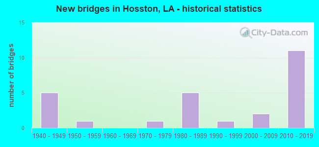
- New bridges - historical statistics
- 51940-1949
- 11950-1959
- 11970-1979
- 51980-1989
- 11990-1999
- 22000-2009
- 112010-2019
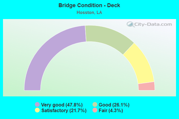
- Bridge Condition - Deck
- 47.8%Very good
- 26.1%Good
- 21.7%Satisfactory
- 4.3%Fair
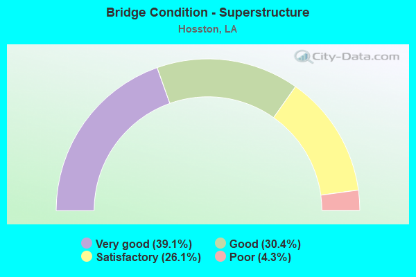
- Bridge Condition - Superstructure
- 39.1%Very good
- 30.4%Good
- 26.1%Satisfactory
- 4.3%Poor
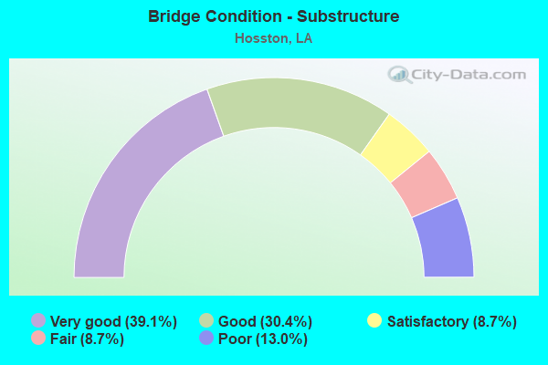
- Bridge Condition - Substructure
- 39.1%Very good
- 30.4%Good
- 8.7%Satisfactory
- 8.7%Fair
- 13.0%Poor
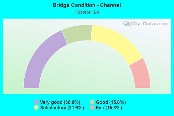
- Bridge Condition - Channel
- 36.8%Very good
- 15.8%Good
- 31.6%Satisfactory
- 15.8%Fair
Find on map >> Show street view
Structure Number: 40800830300001, Location: 3.3 MI EAST OF US 71 (Lat: 32.893089, Lng: -93.823619), Route carried "on" structure: State highway 2, Year Built: 1955, Year Reconstructed: 1992, Status: Open, Structure Length: 94.49m (310.01ft), Average Daily Traffic: 1,740 (year 2016), Truck Traffic: 19%, Average Future Daily Traffic: 1,056 (year 2036), Design Load: H 15, Features Intersected: RED RIVER-MILLER'S BLUFF
Minimum Vertical Clearance: 5.31m (17.42ft), Kilometerpoint: 0.000, Lanes on structure: 2, Owner: State Highway Agency, Approaching Roadway Width: 10.4m (34.1ft), Material/Design: Steel, Design/Construction: Truss - Thru, Number Of Spans In Main Unit: 5, Number Of Approach Spans: 17, Length of Maximum Span: 109.7m (359.9ft), Curb-To-Curb Width: 8.0m (26.2ft), Out-to-Out Width: 8.8m (28.9ft)
Condition: Deck: Fair, Superstructure: Poor, Substructure: Fair, Channel: Satisfactory, Operating Rating: 36.3 metric tons, Method Used To Determine Operating Rating: Load and Resistance Factor Rating (LRFR) rating reported by rating factor(RF) method using HL-93 loadings, Inventory Rating: 28.2 metric tons, Method Used To Determine Inventory Rating: Load and Resistance Factor Rating (LRFR) rating reported by rating factor(RF) method using HL-93 loadings, Structural Evaluation: Meets minimum limits, Deck Geometry: Meets minimum limits, Waterway Adequacy: Equal to present desirable criteria, Approach Roadway Alignment: Equal to present desirable criteria, Length Of Structure Improvement: 94.49m (310.01ft), Designated Inspection Frequency: Every 24 months, Critical Feature Inspection Frequency: Every 24 months, Underwater Inspection Frequency: Every 60 months, Other Special Inspection Frequency: Every 12 months, Inspection Date: July 2021, Critical Feature Inspection Date: July 2021, Underwater Inspection Date: Febuary 2021, Other Special Inspection Date: July 2018, Bridge Improvement Cost: $8,060,000, Total Project Cost: $12,090,000 ( Estimate for 2016), Deck Structure Type: Concrete Cast-file-Place
Find on map >> Show street view
Structure Number: 40900000040265, Location: 7.20 MILES N. OF THE JCT (Lat: 32.922161, Lng: -93.887400), Route carried "on" structure: US 71, Year Built: 2010, Status: Open, Structure Length: 14.94m (49.02ft), Average Daily Traffic: 3,700 (year 2016), Truck Traffic: 26%, Average Future Daily Traffic: 4,366 (year 2036), Design Load: HS 20, Features Intersected: US 71 OVER I-49
Minimum Vertical Clearance: 30+ m (98+ ft), Kilometerpoint: 11.619, Lanes on structure: 2, Lanes under structure: 4, Base Highway Network: Yes (Inventory Route: 11-04-1, Subroute: 10), Owner: State Highway Agency, Approaching Roadway Width: 7.3m (24.0ft), Skew: 30 degrees, Material/Design: Prestressed concrete continuous, Design/Construction: Stringer/Multi-beam, Number Of Spans In Main Unit: 4, Length of Maximum Span: 39.6m (129.9ft), Curb-To-Curb Width: 12.1m (39.7ft), Out-to-Out Width: 13.0m (42.7ft)
Condition: Deck: Very good, Superstructure: Satisfactory, Substructure: Very good, Operating Rating: 49.6 metric tons, Method Used To Determine Operating Rating: Load and Resistance Factor Rating (LRFR) rating reported by rating factor(RF) method using HL-93 loadings, Inventory Rating: 32.7 metric tons, Method Used To Determine Inventory Rating: Load and Resistance Factor Rating (LRFR) rating reported by rating factor(RF) method using HL-93 loadings, Structural Evaluation: Equal to present minimum criteria, Deck Geometry: Somewhat better than minimum adequacy, Underclear: Equal to present minimum criteria, Approach Roadway Alignment: Equal to present desirable criteria, Designated Inspection Frequency: Every 24 months, Inspection Date: January 2022, Deck Structure Type: Concrete Cast-file-Place, Wearing Surface/Protective System: Wearing Surface: Monolithic Concrete
Find on map >> Show street view
Structure Number: 4090000004038, Location: I-49 / US 71 INTG. (Lat: 32.850081, Lng: -93.865200), Route carried "on" structure: Interstate 49, Year Built: 2014, Status: Open, Structure Length: 26.52m (87.01ft), Average Daily Traffic: 5,131 (year 2016), Truck Traffic: 36%, Average Future Daily Traffic: 10,009 (year 2036), Design Load: HL 93, Features Intersected: US 71
Minimum Vertical Clearance: 30+ m (98+ ft), Kilometerpoint: 37.651, Lanes on structure: 2, Lanes under structure: 4, Base Highway Network: Yes (Inventory Route: 455-09-1, Subroute: 10), Owner: State Highway Agency, Approaching Roadway Width: 12.2m (40.0ft), Skew: 35 degrees, Material/Design: Prestressed concrete, Design/Construction: Stringer/Multi-beam, Number Of Spans In Main Unit: 3, Number Of Approach Spans: 6, Length of Maximum Span: 32.3m (106.0ft), Curb-To-Curb Width: 12.1m (39.7ft), Out-to-Out Width: 13.0m (42.7ft)
Condition: Deck: Very good, Superstructure: Very good, Substructure: Good, Operating Rating: 57.3 metric tons, Method Used To Determine Operating Rating: Load and Resistance Factor Rating (LRFR) rating reported by rating factor(RF) method using HL-93 loadings, Inventory Rating: 36.6 metric tons, Method Used To Determine Inventory Rating: Load and Resistance Factor Rating (LRFR) rating reported by rating factor(RF) method using HL-93 loadings, Structural Evaluation: Better than present minimum criteria, Deck Geometry: Equal to present minimum criteria, Underclear: Better than present minimum criteria, Approach Roadway Alignment: Equal to present desirable criteria, Designated Inspection Frequency: Every 24 months, Inspection Date: Febuary 2022, Deck Structure Type: Concrete Cast-file-Place, Wearing Surface/Protective System: Wearing Surface: Monolithic Concrete
Find on map >> Show street view
Structure Number: 40900000040385, Location: I-49 / US 71 INTG. (Lat: 32.852589, Lng: -93.864400), Route carried "on" structure: Interstate 49, Year Built: 2014, Status: Open, Structure Length: 26.52m (87.01ft), Average Daily Traffic: 5,131 (year 2016), Truck Traffic: 36%, Average Future Daily Traffic: 10,009 (year 2036), Design Load: HL 93, Features Intersected: US 71
Minimum Vertical Clearance: 30+ m (98+ ft), Kilometerpoint: 20.152, Lanes on structure: 2, Lanes under structure: 4, Base Highway Network: Yes (Inventory Route: 455-09-2, Subroute: 10), Owner: State Highway Agency, Approaching Roadway Width: 11.6m (38.1ft), Skew: 35 degrees, Material/Design: Prestressed concrete, Design/Construction: Stringer/Multi-beam, Number Of Spans In Main Unit: 3, Number Of Approach Spans: 6, Length of Maximum Span: 32.3m (106.0ft), Curb-To-Curb Width: 12.1m (39.7ft), Out-to-Out Width: 13.0m (42.7ft)
Condition: Deck: Very good, Superstructure: Good, Substructure: Good, Operating Rating: 41.5 metric tons, Method Used To Determine Operating Rating: Load and Resistance Factor Rating (LRFR) rating reported by rating factor(RF) method using HL-93 loadings, Inventory Rating: 32.1 metric tons, Method Used To Determine Inventory Rating: Load and Resistance Factor Rating (LRFR) rating reported by rating factor(RF) method using HL-93 loadings, Structural Evaluation: Better than present minimum criteria, Deck Geometry: Equal to present minimum criteria, Underclear: High priority of corrective action, Approach Roadway Alignment: Equal to present desirable criteria, Designated Inspection Frequency: Every 24 months, Inspection Date: Febuary 2022, Deck Structure Type: Concrete Cast-file-Place, Wearing Surface/Protective System: Wearing Surface: Monolithic Concrete
Find on map >> Show street view
Structure Number: 40900000040391, Location: 2.14 M. N. OF US 71 (Lat: 32.880311, Lng: -93.860000), Route carried "on" structure: Interstate 49, Year Built: 2014, Status: Open, Structure Length: 5.30m (17.39ft), Average Daily Traffic: 5,131 (year 2016), Truck Traffic: 36%, Average Future Daily Traffic: 11,210 (year 2036), Design Load: HL 93, Features Intersected: HOSSTON RIVER RD.
Minimum Vertical Clearance: 30+ m (98+ ft), Kilometerpoint: 41.083, Lanes on structure: 2, Lanes under structure: 1, Base Highway Network: Yes (Inventory Route: 455-09-1, Subroute: 10), Owner: State Highway Agency, Approaching Roadway Width: 12.2m (40.0ft), Skew: 33 degrees, Material/Design: Prestressed concrete continuous, Design/Construction: Stringer/Multi-beam, Number Of Spans In Main Unit: 3, Length of Maximum Span: 17.7m (58.1ft), Curb-To-Curb Width: 12.2m (40.0ft), Out-to-Out Width: 13.0m (42.7ft)
Condition: Deck: Very good, Superstructure: Very good, Substructure: Very good, Operating Rating: 56.4 metric tons, Method Used To Determine Operating Rating: Load and Resistance Factor Rating (LRFR) rating reported by rating factor(RF) method using HL-93 loadings, Inventory Rating: 34.0 metric tons, Method Used To Determine Inventory Rating: Load and Resistance Factor Rating (LRFR) rating reported by rating factor(RF) method using HL-93 loadings, Structural Evaluation: Equal to present desirable criteria, Deck Geometry: Better than present minimum criteria, Underclear: Better than present minimum criteria, Approach Roadway Alignment: Equal to present desirable criteria, Designated Inspection Frequency: Every 24 months, Inspection Date: April 2020, Deck Structure Type: Concrete Cast-file-Place, Wearing Surface/Protective System: Wearing Surface: Monolithic Concrete
Find on map >> Show street view
Structure Number: 40900000040392, Location: 2.14 M. NORTH OF US 71 (Lat: 32.881000, Lng: -93.860400), Route carried "on" structure: Interstate 49, Year Built: 2014, Status: Open, Structure Length: 5.30m (17.39ft), Average Daily Traffic: 5,131 (year 2016), Truck Traffic: 36%, Average Future Daily Traffic: 11,210 (year 2036), Design Load: HL 93, Features Intersected: HOSSTON RIVER RD.
Minimum Vertical Clearance: 30+ m (98+ ft), Kilometerpoint: 16.946, Lanes on structure: 2, Lanes under structure: 1, Base Highway Network: Yes (Inventory Route: 455-09-2, Subroute: 10), Owner: State Highway Agency, Approaching Roadway Width: 12.2m (40.0ft), Skew: 33 degrees, Material/Design: Prestressed concrete continuous, Design/Construction: Stringer/Multi-beam, Number Of Spans In Main Unit: 3, Length of Maximum Span: 17.7m (58.1ft), Curb-To-Curb Width: 12.3m (40.4ft), Out-to-Out Width: 13.0m (42.7ft)
Condition: Deck: Very good, Superstructure: Good, Substructure: Very good, Operating Rating: 56.4 metric tons, Method Used To Determine Operating Rating: Load and Resistance Factor Rating (LRFR) rating reported by rating factor(RF) method using HL-93 loadings, Inventory Rating: 34.0 metric tons, Method Used To Determine Inventory Rating: Load and Resistance Factor Rating (LRFR) rating reported by rating factor(RF) method using HL-93 loadings, Structural Evaluation: Better than present minimum criteria, Deck Geometry: Better than present minimum criteria, Underclear: Better than present minimum criteria, Approach Roadway Alignment: Equal to present desirable criteria, Designated Inspection Frequency: Every 24 months, Inspection Date: April 2020, Deck Structure Type: Concrete Cast-file-Place, Wearing Surface/Protective System: Wearing Surface: Monolithic Concrete
Find on map >> Show street view
Structure Number: 40900000040393, Location: 3.48 M. N. OF US 71 (Lat: 32.899361, Lng: -93.862100), Route carried "on" structure: Interstate 49, Year Built: 2014, Status: Open, Structure Length: 7.07m (23.20ft), Average Daily Traffic: 5,131 (year 2016), Truck Traffic: 36%, Average Future Daily Traffic: 11,210 (year 2036), Design Load: HL 93, Features Intersected: KELLY BAYOU
Minimum Vertical Clearance: 30+ m (98+ ft), Kilometerpoint: 43.219, Lanes on structure: 2, Base Highway Network: Yes (Inventory Route: 455-09-1, Subroute: 10), Owner: State Highway Agency, Approaching Roadway Width: 12.2m (40.0ft), Skew: 37 degrees, Material/Design: Prestressed concrete continuous, Design/Construction: Stringer/Multi-beam, Number Of Spans In Main Unit: 4, Length of Maximum Span: 17.7m (58.1ft), Curb-To-Curb Width: 12.1m (39.7ft), Out-to-Out Width: 13.0m (42.7ft)
Condition: Deck: Very good, Superstructure: Very good, Substructure: Very good, Channel: Very good, Operating Rating: 57.7 metric tons, Method Used To Determine Operating Rating: Load and Resistance Factor Rating (LRFR) rating reported by rating factor(RF) method using HL-93 loadings, Inventory Rating: 33.4 metric tons, Method Used To Determine Inventory Rating: Load and Resistance Factor Rating (LRFR) rating reported by rating factor(RF) method using HL-93 loadings, Structural Evaluation: Equal to present desirable criteria, Deck Geometry: Equal to present minimum criteria, Waterway Adequacy: Equal to present desirable criteria, Approach Roadway Alignment: Equal to present desirable criteria, Designated Inspection Frequency: Every 24 months, Underwater Inspection Frequency: Every 60 months, Inspection Date: April 2020, Underwater Inspection Date: July 2020, Deck Structure Type: Concrete Cast-file-Place, Wearing Surface/Protective System: Wearing Surface: Monolithic Concrete
Find on map >> Show street view
Structure Number: 40900000040394, Location: 3.48 M. N. OF US 71 (Lat: 32.899931, Lng: -93.862800), Route carried "on" structure: Interstate 49, Year Built: 2014, Status: Open, Structure Length: 7.07m (23.20ft), Average Daily Traffic: 5,131 (year 2016), Truck Traffic: 36%, Average Future Daily Traffic: 11,210 (year 2036), Design Load: HL 93, Features Intersected: KELLY BAYOU
Minimum Vertical Clearance: 30+ m (98+ ft), Kilometerpoint: 14.819, Lanes on structure: 2, Base Highway Network: Yes (Inventory Route: 455-09-2, Subroute: 10), Owner: State Highway Agency, Approaching Roadway Width: 12.2m (40.0ft), Skew: 37 degrees, Material/Design: Prestressed concrete continuous, Design/Construction: Stringer/Multi-beam, Number Of Spans In Main Unit: 4, Length of Maximum Span: 17.7m (58.1ft), Curb-To-Curb Width: 12.2m (40.0ft), Out-to-Out Width: 13.0m (42.7ft)
Condition: Deck: Very good, Superstructure: Very good, Substructure: Very good, Channel: Very good, Operating Rating: 57.7 metric tons, Method Used To Determine Operating Rating: Load and Resistance Factor Rating (LRFR) rating reported by rating factor(RF) method using HL-93 loadings, Inventory Rating: 33.4 metric tons, Method Used To Determine Inventory Rating: Load and Resistance Factor Rating (LRFR) rating reported by rating factor(RF) method using HL-93 loadings, Structural Evaluation: Equal to present desirable criteria, Deck Geometry: Better than present minimum criteria, Waterway Adequacy: Equal to present desirable criteria, Approach Roadway Alignment: Equal to present desirable criteria, Designated Inspection Frequency: Every 24 months, Underwater Inspection Frequency: Every 60 months, Inspection Date: April 2020, Underwater Inspection Date: July 2020, Deck Structure Type: Concrete Cast-file-Place, Wearing Surface/Protective System: Wearing Surface: Monolithic Concrete
Find on map >> Show street view
Structure Number: 40900000040395, Location: I-49 / LA 2 INTG. (Lat: 32.899819, Lng: -93.860461), Route carried "on" structure: Ramp Interstate 49, Year Built: 2014, Status: Open, Structure Length: 6.71m (22.01ft), Average Daily Traffic: 1,026 (year 2016), Truck Traffic: 36%, Average Future Daily Traffic: 11,210 (year 2036), Design Load: HL 93, Features Intersected: KELLY BAYOU
Minimum Vertical Clearance: 30+ m (98+ ft), Kilometerpoint: 0.341, Lanes on structure: 1, Owner: State Highway Agency, Approaching Roadway Width: 8.5m (27.9ft), Skew: 37 degrees, Material/Design: Concrete, Design/Construction: Slab, Number Of Spans In Main Unit: 11, Length of Maximum Span: 6.1m (20.0ft), Curb-To-Curb Width: 7.6m (24.9ft), Out-to-Out Width: 8.5m (27.9ft)
Condition: Deck: Very good, Superstructure: Very good, Substructure: Very good, Channel: Good, Operating Rating: 41.8 metric tons, Method Used To Determine Operating Rating: Load and Resistance Factor Rating (LRFR) rating reported by rating factor(RF) method using HL-93 loadings, Inventory Rating: 32.1 metric tons, Method Used To Determine Inventory Rating: Load and Resistance Factor Rating (LRFR) rating reported by rating factor(RF) method using HL-93 loadings, Structural Evaluation: Better than present minimum criteria, Deck Geometry: Better than present minimum criteria, Waterway Adequacy: Equal to present desirable criteria, Approach Roadway Alignment: Equal to present desirable criteria, Designated Inspection Frequency: Every 24 months, Underwater Inspection Frequency: Every 60 months, Inspection Date: April 2020, Underwater Inspection Date: July 2020, Deck Structure Type: Concrete Cast-file-Place, Wearing Surface/Protective System: Wearing Surface: Monolithic Concrete
Find on map >> Show street view
Structure Number: 40900000040396, Location: 3.5 M. N. OF US 71 (Lat: 32.899869, Lng: -93.863700), Route carried "on" structure: Ramp Interstate 49, Year Built: 2014, Status: Open, Structure Length: 6.71m (22.01ft), Average Daily Traffic: 1,026 (year 2016), Truck Traffic: 36%, Average Future Daily Traffic: 1,129 (year 2036), Design Load: HL 93, Features Intersected: KELLY BAYOU
Minimum Vertical Clearance: 30+ m (98+ ft), Kilometerpoint: 0.341, Lanes on structure: 1, Owner: State Highway Agency, Approaching Roadway Width: 7.6m (24.9ft), Skew: 37 degrees, Material/Design: Concrete, Design/Construction: Slab, Number Of Spans In Main Unit: 11, Length of Maximum Span: 6.1m (20.0ft), Curb-To-Curb Width: 7.7m (25.3ft), Out-to-Out Width: 8.5m (27.9ft)
Condition: Deck: Very good, Superstructure: Very good, Substructure: Very good, Channel: Very good, Operating Rating: 41.8 metric tons, Method Used To Determine Operating Rating: Load and Resistance Factor Rating (LRFR) rating reported by rating factor(RF) method using HL-93 loadings, Inventory Rating: 32.1 metric tons, Method Used To Determine Inventory Rating: Load and Resistance Factor Rating (LRFR) rating reported by rating factor(RF) method using HL-93 loadings, Structural Evaluation: Better than present minimum criteria, Deck Geometry: Better than present minimum criteria, Waterway Adequacy: Equal to present desirable criteria, Approach Roadway Alignment: Equal to present desirable criteria, Designated Inspection Frequency: Every 24 months, Inspection Date: April 2020, Deck Structure Type: Concrete Cast-file-Place, Wearing Surface/Protective System: Wearing Surface: Monolithic Concrete
Find on map >> Show street view
Structure Number: 40900000040397, Location: I-49 / LA 2 INTG. (Lat: 32.896650, Lng: -93.861100), Route carried "on" structure: Interstate 49, Year Built: 2014, Status: Open, Structure Length: 8.84m (29.00ft), Average Daily Traffic: 5,131 (year 2016), Truck Traffic: 36%, Average Future Daily Traffic: 11,210 (year 2036), Design Load: HL 93, Features Intersected: LA 2
Minimum Vertical Clearance: 30+ m (98+ ft), Kilometerpoint: 42.902, Lanes on structure: 2, Lanes under structure: 2, Base Highway Network: Yes (Inventory Route: 455-09-1, Subroute: 10), Owner: State Highway Agency, Approaching Roadway Width: 12.2m (40.0ft), Skew: 37 degrees, Material/Design: Prestressed concrete continuous, Design/Construction: Stringer/Multi-beam, Number Of Spans In Main Unit: 3, Length of Maximum Span: 33.5m (109.9ft), Curb-To-Curb Width: 12.0m (39.4ft), Out-to-Out Width: 12.9m (42.3ft)
Condition: Deck: Very good, Superstructure: Very good, Substructure: Good, Operating Rating: 59.0 metric tons, Method Used To Determine Operating Rating: Load and Resistance Factor Rating (LRFR) rating reported by rating factor(RF) method using HL-93 loadings, Inventory Rating: 38.9 metric tons, Method Used To Determine Inventory Rating: Load and Resistance Factor Rating (LRFR) rating reported by rating factor(RF) method using HL-93 loadings, Structural Evaluation: Better than present minimum criteria, Deck Geometry: Equal to present minimum criteria, Underclear: Equal to present minimum criteria, Approach Roadway Alignment: Equal to present desirable criteria, Designated Inspection Frequency: Every 24 months, Inspection Date: June 2020, Deck Structure Type: Concrete Cast-file-Place, Wearing Surface/Protective System: Wearing Surface: Monolithic Concrete
Find on map >> Show street view
Structure Number: 40900000040398, Location: I-49 / LA 2 INTG. (Lat: 32.897389, Lng: -93.861800), Route carried "on" structure: Interstate 49, Year Built: 2014, Status: Open, Structure Length: 8.78m (28.81ft), Average Daily Traffic: 5,131 (year 2016), Truck Traffic: 36%, Average Future Daily Traffic: 11,210 (year 2036), Design Load: HL 93, Features Intersected: LA 2
Minimum Vertical Clearance: 30+ m (98+ ft), Kilometerpoint: 15.113, Lanes on structure: 2, Lanes under structure: 2, Base Highway Network: Yes (Inventory Route: 455-09-2, Subroute: 10), Owner: State Highway Agency, Approaching Roadway Width: 12.2m (40.0ft), Skew: 37 degrees, Material/Design: Prestressed concrete continuous, Design/Construction: Stringer/Multi-beam, Number Of Spans In Main Unit: 3, Length of Maximum Span: 33.2m (108.9ft), Curb-To-Curb Width: 12.0m (39.4ft), Out-to-Out Width: 12.9m (42.3ft)
Condition: Deck: Very good, Superstructure: Very good, Substructure: Very good, Operating Rating: 60.3 metric tons, Method Used To Determine Operating Rating: Load and Resistance Factor Rating (LRFR) rating reported by rating factor(RF) method using HL-93 loadings, Inventory Rating: 40.2 metric tons, Method Used To Determine Inventory Rating: Load and Resistance Factor Rating (LRFR) rating reported by rating factor(RF) method using HL-93 loadings, Structural Evaluation: Equal to present desirable criteria, Deck Geometry: Equal to present minimum criteria, Underclear: Equal to present minimum criteria, Approach Roadway Alignment: Equal to present desirable criteria, Designated Inspection Frequency: Every 24 months, Inspection Date: June 2020, Deck Structure Type: Concrete Cast-file-Place, Wearing Surface/Protective System: Wearing Surface: Monolithic Concrete
Find on map >> Show street view
Structure Number: 40900110402451, Location: 2.4 MI N OF JCT. LA 170 (Lat: 32.857531, Lng: -93.869400), Route carried "on" structure: US 71, Year Built: 2001, Status: Open, Structure Length: 7.19m (23.59ft), Average Daily Traffic: 3,700 (year 2016), Truck Traffic: 26%, Average Future Daily Traffic: 4,602 (year 2036), Design Load: HS 20, Features Intersected: KELLY BAYOU
Minimum Vertical Clearance: 30+ m (98+ ft), Kilometerpoint: 3.975, Lanes on structure: 2, Base Highway Network: Yes (Inventory Route: 11-04-1, Subroute: 10), Owner: State Highway Agency, Approaching Roadway Width: 11.9m (39.0ft), Skew: 7 degrees, Material/Design: Prestressed concrete continuous, Design/Construction: Stringer/Multi-beam, Number Of Spans In Main Unit: 5, Length of Maximum Span: 14.3m (46.9ft), Curb-To-Curb Width: 13.1m (43.0ft), Out-to-Out Width: 14.0m (45.9ft)
Condition: Deck: Good, Superstructure: Good, Substructure: Good, Channel: Very good, Operating Rating: 81.6 metric tons, Method Used To Determine Operating Rating: Load Factor (LF), Inventory Rating: 43.5 metric tons, Method Used To Determine Inventory Rating: Load Factor (LF), Structural Evaluation: Better than present minimum criteria, Deck Geometry: Equal to present minimum criteria, Waterway Adequacy: Equal to present desirable criteria, Approach Roadway Alignment: Equal to present desirable criteria, Designated Inspection Frequency: Every 24 months, Inspection Date: January 2021, Deck Structure Type: Concrete Cast-file-Place
Find on map >> Show street view
Structure Number: 40900830103141, Location: 3.14 MI EAST OF LA 1 (Lat: 32.869919, Lng: -93.929300), Route carried "on" structure: State highway 2, Year Built: 1948, Status: Open, Structure Length: 1.19m (3.90ft), Average Daily Traffic: 2,900 (year 2016), Truck Traffic: 19%, Average Future Daily Traffic: 3,422 (year 2036), Design Load: HS 20, Features Intersected: LOWE CREEK
Minimum Vertical Clearance: 30+ m (98+ ft), Kilometerpoint: 5.069, Lanes on structure: 2, Owner: State Highway Agency, Approaching Roadway Width: 10.7m (35.1ft), Material/Design: Concrete, Design/Construction: Culvert, Number Of Spans In Main Unit: 3, Length of Maximum Span: 3.7m (12.1ft)
Condition: Channel: Fair, Culverts: Satisfactory, Operating Rating: 42.1 metric tons, Method Used To Determine Operating Rating: Load and Resistance Factor Rating (LRFR) rating reported by rating factor(RF) method using HL-93 loadings, Inventory Rating: 32.4 metric tons, Method Used To Determine Inventory Rating: Load and Resistance Factor Rating (LRFR) rating reported by rating factor(RF) method using HL-93 loadings, Structural Evaluation: Equal to present minimum criteria, Waterway Adequacy: Equal to present minimum criteria, Approach Roadway Alignment: Equal to present desirable criteria, Designated Inspection Frequency: Every 24 months, Inspection Date: Febuary 2022, Deck Structure Type: Concrete Cast-file-Place
Find on map >> Show street view
Structure Number: 40900830105151, Location: 5.15 MI EAST OF LA 1 (Lat: 32.881569, Lng: -93.899000), Route carried "on" structure: State highway 2, Year Built: 1980, Status: Open, Structure Length: 12.19m (39.99ft), Average Daily Traffic: 2,900 (year 2016), Truck Traffic: 19%, Average Future Daily Traffic: 3,422 (year 2036), Design Load: HS 20, Features Intersected: BLACK BAYOU
Minimum Vertical Clearance: 30+ m (98+ ft), Kilometerpoint: 8.291, Lanes on structure: 2, Owner: State Highway Agency, Approaching Roadway Width: 12.2m (40.0ft), Material/Design: Concrete, Design/Construction: Slab, Number Of Spans In Main Unit: 16, Length of Maximum Span: 7.6m (24.9ft), Curb-To-Curb Width: 12.2m (40.0ft), Out-to-Out Width: 13.0m (42.7ft)
Condition: Deck: Satisfactory, Superstructure: Satisfactory, Substructure: Fair, Channel: Very good, Operating Rating: 46.3 metric tons, Method Used To Determine Operating Rating: Load and Resistance Factor Rating (LRFR) rating reported by rating factor(RF) method using HL-93 loadings, Inventory Rating: 35.6 metric tons, Method Used To Determine Inventory Rating: Load and Resistance Factor Rating (LRFR) rating reported by rating factor(RF) method using HL-93 loadings, Structural Evaluation: Somewhat better than minimum adequacy, Deck Geometry: Equal to present minimum criteria, Waterway Adequacy: Equal to present desirable criteria, Approach Roadway Alignment: Equal to present desirable criteria, Designated Inspection Frequency: Every 24 months, Inspection Date: January 2021, Deck Structure Type: Concrete Cast-file-Place
Find on map >> Show street view
Structure Number: 40900830105941, Location: 5.94 MI EAST OF LA 1 (Lat: 32.884419, Lng: -93.886100), Route carried "on" structure: State highway 2, Year Built: 1948, Status: Open, Structure Length: 0.88m (2.89ft), Average Daily Traffic: 1,500 (year 2016), Truck Traffic: 19%, Average Future Daily Traffic: 1,781 (year 2036), Design Load: HS 20, Features Intersected: CREEK
Minimum Vertical Clearance: 30+ m (98+ ft), Kilometerpoint: 9.553, Lanes on structure: 2, Owner: State Highway Agency, Approaching Roadway Width: 11.3m (37.1ft), Material/Design: Concrete, Design/Construction: Culvert, Number Of Spans In Main Unit: 5, Length of Maximum Span: 1.5m (4.9ft)
Condition: Channel: Fair, Culverts: Satisfactory, Operating Rating: 42.1 metric tons, Method Used To Determine Operating Rating: Load and Resistance Factor Rating (LRFR) rating reported by rating factor(RF) method using HL-93 loadings, Inventory Rating: 32.4 metric tons, Method Used To Determine Inventory Rating: Load and Resistance Factor Rating (LRFR) rating reported by rating factor(RF) method using HL-93 loadings, Structural Evaluation: Equal to present minimum criteria, Waterway Adequacy: Somewhat better than minimum adequacy, Approach Roadway Alignment: Equal to present minimum criteria, Designated Inspection Frequency: Every 24 months, Inspection Date: Febuary 2022, Deck Structure Type: Concrete Cast-file-Place
Find on map >> Show street view
Structure Number: 40900830105991, Location: 5.99 MI EAST OF LA 1 (Lat: 32.884419, Lng: -93.885200), Route carried "on" structure: State highway 2, Year Built: 1948, Status: Open, Structure Length: 0.82m (2.69ft), Average Daily Traffic: 1,500 (year 2016), Truck Traffic: 19%, Average Future Daily Traffic: 1,781 (year 2036), Design Load: HS 20, Features Intersected: CREEK
Minimum Vertical Clearance: 30+ m (98+ ft), Kilometerpoint: 9.630, Lanes on structure: 2, Owner: State Highway Agency, Approaching Roadway Width: 11.3m (37.1ft), Material/Design: Concrete, Design/Construction: Culvert, Number Of Spans In Main Unit: 5, Length of Maximum Span: 1.5m (4.9ft)
Condition: Channel: Fair, Culverts: Satisfactory, Operating Rating: 42.1 metric tons, Method Used To Determine Operating Rating: Load and Resistance Factor Rating (LRFR) rating reported by rating factor(RF) method using HL-93 loadings, Inventory Rating: 32.4 metric tons, Method Used To Determine Inventory Rating: Load and Resistance Factor Rating (LRFR) rating reported by rating factor(RF) method using HL-93 loadings, Structural Evaluation: Equal to present minimum criteria, Waterway Adequacy: Somewhat better than minimum adequacy, Approach Roadway Alignment: Equal to present minimum criteria, Designated Inspection Frequency: Every 24 months, Inspection Date: Febuary 2022, Deck Structure Type: Concrete Cast-file-Place
Find on map >> Show street view
Structure Number: 40900830200471, Location: 0.47 MI EAST OF US 71 (Lat: 32.894139, Lng: -93.871200), Route carried "on" structure: State highway 200, Year Built: 2006, Status: Open, Structure Length: 6.58m (21.59ft), Average Daily Traffic: 1,740 (year 2016), Truck Traffic: 19%, Average Future Daily Traffic: 2,076 (year 2036), Design Load: HS 20, Features Intersected: KELLY BAYOU, Facility Carried by Structure: LA0002
Minimum Vertical Clearance: 30+ m (98+ ft), Kilometerpoint: 0.734, Lanes on structure: 2, Owner: State Highway Agency, Approaching Roadway Width: 7.9m (25.9ft), Skew: 6 degrees, Material/Design: Prestressed concrete continuous, Design/Construction: Stringer/Multi-beam, Number Of Spans In Main Unit: 4, Length of Maximum Span: 16.5m (54.1ft), Curb-To-Curb Width: 13.1m (43.0ft), Out-to-Out Width: 14.2m (46.6ft)
Condition: Deck: Good, Superstructure: Very good, Substructure: Very good, Channel: Very good, Operating Rating: 52.5 metric tons, Method Used To Determine Operating Rating: Load and Resistance Factor Rating (LRFR) rating reported by rating factor(RF) method using HL-93 loadings, Inventory Rating: 29.8 metric tons, Method Used To Determine Inventory Rating: Load and Resistance Factor Rating (LRFR) rating reported by rating factor(RF) method using HL-93 loadings, Structural Evaluation: Better than present minimum criteria, Deck Geometry: Better than present minimum criteria, Waterway Adequacy: Equal to present desirable criteria, Approach Roadway Alignment: Equal to present desirable criteria, Designated Inspection Frequency: Every 24 months, Inspection Date: Febuary 2022, Deck Structure Type: Concrete Cast-file-Place
Find on map >> Show street view
Structure Number: 40932509935301, Location: 1.5 MI W OF US 71 IN (Lat: 32.848139, Lng: -93.883711), Route carried "on" structure: County highway , Year Built: 1980, Status: Posted for load, Structure Length: 8.17m (26.80ft), Average Daily Traffic: 80 (year 2019), Average Future Daily Traffic: 247 (year 2036), Design Load: HS 20, Features Intersected: HUCKABY RD., KELLY B., Facility Carried by Structure: Huckaby Rd
Minimum Vertical Clearance: 30+ m (98+ ft), Kilometerpoint: 0.000, Lanes on structure: 2, Owner: County Highway Agency, Approaching Roadway Width: 10.1m (33.1ft), Material/Design: Concrete, Design/Construction: Slab, Number Of Spans In Main Unit: 14, Length of Maximum Span: 5.8m (19.0ft), Curb-To-Curb Width: 8.7m (28.5ft), Out-to-Out Width: 9.4m (30.8ft)
Condition: Deck: Satisfactory, Superstructure: Satisfactory, Substructure: Poor, Channel: Satisfactory, Operating Rating: 30.1 metric tons, Method Used To Determine Operating Rating: Load and Resistance Factor Rating (LRFR) rating reported by rating factor(RF) method using HL-93 loadings, Inventory Rating: 23.3 metric tons, Method Used To Determine Inventory Rating: Load and Resistance Factor Rating (LRFR) rating reported by rating factor(RF) method using HL-93 loadings, Structural Evaluation: Meets minimum limits, Deck Geometry: Better than present minimum criteria, Waterway Adequacy: Better than present minimum criteria, Approach Roadway Alignment: Equal to present desirable criteria, Designated Inspection Frequency: Every 24 months, Other Special Inspection Frequency: Every 12 months, Inspection Date: March 2021, Other Special Inspection Date: March 2020, Deck Structure Type: Concrete Precast Panels, Wearing Surface/Protective System: Wearing Surface: Bituminous
Find on map >> Show street view
Structure Number: 40932509935391, Location: 1.45 MI W OF US 71 (Lat: 32.848081, Lng: -93.898069), Route carried "on" structure: County highway , Year Built: 1979, Status: Posted for load, Structure Length: 6.43m (21.10ft), Average Daily Traffic: 211 (year 2019), Average Future Daily Traffic: 247 (year 2036), Design Load: HS 20, Features Intersected: HUCKABY RD., BLACK B.CA, Facility Carried by Structure: Huckaby Rd
Minimum Vertical Clearance: 30+ m (98+ ft), Kilometerpoint: 0.000, Lanes on structure: 2, Owner: County Highway Agency, Approaching Roadway Width: 8.2m (26.9ft), Material/Design: Concrete, Design/Construction: Slab, Number Of Spans In Main Unit: 11, Length of Maximum Span: 5.8m (19.0ft), Curb-To-Curb Width: 8.6m (28.2ft), Out-to-Out Width: 9.5m (31.2ft)
Condition: Deck: Satisfactory, Superstructure: Satisfactory, Substructure: Poor, Channel: Satisfactory, Operating Rating: 30.1 metric tons, Method Used To Determine Operating Rating: Load and Resistance Factor Rating (LRFR) rating reported by rating factor(RF) method using HL-93 loadings, Inventory Rating: 23.3 metric tons, Method Used To Determine Inventory Rating: Load and Resistance Factor Rating (LRFR) rating reported by rating factor(RF) method using HL-93 loadings, Structural Evaluation: Meets minimum limits, Deck Geometry: Equal to present minimum criteria, Waterway Adequacy: Better than present minimum criteria, Approach Roadway Alignment: Equal to present desirable criteria, Designated Inspection Frequency: Every 24 months, Underwater Inspection Frequency: Every 60 months, Other Special Inspection Frequency: Every 12 months, Inspection Date: March 2021, Underwater Inspection Date: July 2020, Other Special Inspection Date: March 2020, Deck Structure Type: Concrete Precast Panels, Wearing Surface/Protective System: Wearing Surface: Bituminous
Find on map >> Show street view
Structure Number: 40932529935191, Location: 0.8 MILES E OF INT. US 71 (Lat: 32.882369, Lng: -93.864900), Route carried "on" structure: County highway , Year Built: 1981, Status: Posted for load, Structure Length: 4.48m (14.70ft), Average Daily Traffic: 147 (year 2019), Average Future Daily Traffic: 82 (year 2036), Design Load: HS 20, Features Intersected: HOSSTON R. RD, KELLY B., Facility Carried by Structure: Hosston River Rd
Minimum Vertical Clearance: 30+ m (98+ ft), Kilometerpoint: 0.000, Lanes on structure: 2, Owner: County Highway Agency, Approaching Roadway Width: 7.6m (24.9ft), Material/Design: Steel, Design/Construction: Stringer/Multi-beam, Number Of Spans In Main Unit: 7, Length of Maximum Span: 8.8m (28.9ft), Curb-To-Curb Width: 5.9m (19.4ft), Out-to-Out Width: 6.1m (20.0ft)
Condition: Deck: Satisfactory, Superstructure: Satisfactory, Substructure: Poor, Channel: Very good, Operating Rating: 13.0 metric tons, Method Used To Determine Operating Rating: Load and Resistance Factor Rating (LRFR) rating reported by rating factor(RF) method using HL-93 loadings, Inventory Rating: 9.7 metric tons, Method Used To Determine Inventory Rating: Load and Resistance Factor Rating (LRFR) rating reported by rating factor(RF) method using HL-93 loadings, Structural Evaluation: High priority of replacement, Deck Geometry: High priority of corrective action, Waterway Adequacy: Better than present minimum criteria, Approach Roadway Alignment: High priority of corrective action, Bridge Posting: Required (Relationship of Operating Rating to Maximum Legal Load: > 39.9% below), Length Of Structure Improvement: 5.40m (17.72ft), Designated Inspection Frequency: Every 24 months, Underwater Inspection Frequency: Every 60 months, Other Special Inspection Frequency: Every 6 months, Inspection Date: March 2021, Underwater Inspection Date: July 2020, Other Special Inspection Date: September 2021, Bridge Improvement Cost: $322,000, Total Project Cost: $483,000 ( Estimate for 2016), Deck Structure Type: Wood or Timber, Wearing Surface/Protective System: Wearing Surface: Other
Find on map >> Show street view
Structure Number: 40932535935301, Location: 0.25 MI WEST OF US HWY 72 (Lat: 32.892139, Lng: -93.884761), Route carried "on" structure: County highway , Year Built: 1989, Status: Open, Structure Length: 1.80m (5.91ft), Average Daily Traffic: 59 (year 2019), Average Future Daily Traffic: 776 (year 2036), Design Load: HS 20, Features Intersected: BLACK BAYOU TRIB, Facility Carried by Structure: Hosston Rodessa Rd
Minimum Vertical Clearance: 30+ m (98+ ft), Kilometerpoint: 0.000, Lanes on structure: 2, Owner: County Highway Agency, Approaching Roadway Width: 11.9m (39.0ft), Material/Design: Concrete, Design/Construction: Slab, Number Of Spans In Main Unit: 3, Length of Maximum Span: 5.8m (19.0ft), Curb-To-Curb Width: 8.6m (28.2ft), Out-to-Out Width: 9.4m (30.8ft)
Condition: Deck: Good, Superstructure: Good, Substructure: Good, Channel: Satisfactory, Operating Rating: 27.2 metric tons, Method Used To Determine Operating Rating: Load and Resistance Factor Rating (LRFR) rating reported by rating factor(RF) method using HL-93 loadings, Inventory Rating: 21.1 metric tons, Method Used To Determine Inventory Rating: Load and Resistance Factor Rating (LRFR) rating reported by rating factor(RF) method using HL-93 loadings, Structural Evaluation: Equal to present minimum criteria, Deck Geometry: Better than present minimum criteria, Waterway Adequacy: Equal to present desirable criteria, Approach Roadway Alignment: Equal to present desirable criteria, Designated Inspection Frequency: Every 24 months, Inspection Date: Febuary 2021, Deck Structure Type: Concrete Precast Panels
Find on map >> Show street view
Structure Number: 40932546934971, Location: 3.5 MI E OF US 71 (Lat: 32.909669, Lng: -93.829211), Route carried "on" structure: County highway , Year Built: 1947, Status: Posted for load, Structure Length: 0.94m (3.08ft), Average Daily Traffic: 31 (year 2019), Average Future Daily Traffic: 59 (year 2036), Design Load: HS 15, Features Intersected: TRIBUTARY TO STUMPY BAYO, Facility Carried by Structure: Hosston Miller Blf
Minimum Vertical Clearance: 30+ m (98+ ft), Kilometerpoint: 0.000, Lanes on structure: 2, Owner: County Highway Agency, Approaching Roadway Width: 8.2m (26.9ft), Material/Design: Concrete, Design/Construction: Slab, Number Of Spans In Main Unit: 2, Length of Maximum Span: 4.6m (15.1ft), Curb-To-Curb Width: 8.3m (27.2ft), Out-to-Out Width: 8.8m (28.9ft)
Condition: Deck: Satisfactory, Superstructure: Satisfactory, Substructure: Satisfactory, Channel: Satisfactory, Operating Rating: 15.9 metric tons, Method Used To Determine Operating Rating: Load and Resistance Factor Rating (LRFR) rating reported by rating factor(RF) method using HL-93 loadings, Inventory Rating: 12.3 metric tons, Method Used To Determine Inventory Rating: Load and Resistance Factor Rating (LRFR) rating reported by rating factor(RF) method using HL-93 loadings, Structural Evaluation: Meets minimum limits, Deck Geometry: Equal to present minimum criteria, Waterway Adequacy: Meets minimum limits, Approach Roadway Alignment: Equal to present desirable criteria, Bridge Posting: Required (Relationship of Operating Rating to Maximum Legal Load: 20.0 - 29.9% below), Designated Inspection Frequency: Every 24 months, Inspection Date: March 2021, Deck Structure Type: Concrete Cast-file-Place, Wearing Surface/Protective System: Wearing Surface: Other
Find on map >> Show street view
Structure Number: 40932546935421, Location: 2.0 M. W. OF US 71 (Lat: 32.910481, Lng: -93.904019), Route carried "on" structure: County highway , Year Built: 1998, Status: Open, Structure Length: 1.74m (5.71ft), Average Daily Traffic: 57 (year 2019), Average Future Daily Traffic: 776 (year 2036), Design Load: HS 20, Features Intersected: TRIB.TO BLACKLAKE BAYOU, Facility Carried by Structure: Hosston Rodessa Rd
Minimum Vertical Clearance: 30+ m (98+ ft), Kilometerpoint: 0.000, Lanes on structure: 2, Base Highway Network: Yes, Owner: County Highway Agency, Approaching Roadway Width: 8.5m (27.9ft), Material/Design: Concrete, Design/Construction: Slab, Number Of Spans In Main Unit: 3, Length of Maximum Span: 5.8m (19.0ft), Curb-To-Curb Width: 8.5m (27.9ft), Out-to-Out Width: 9.4m (30.8ft)
Condition: Deck: Good, Superstructure: Good, Substructure: Good, Channel: Good, Operating Rating: 37.9 metric tons, Method Used To Determine Operating Rating: Load and Resistance Factor Rating (LRFR) rating reported by rating factor(RF) method using HL-93 loadings, Inventory Rating: 29.2 metric tons, Method Used To Determine Inventory Rating: Load and Resistance Factor Rating (LRFR) rating reported by rating factor(RF) method using HL-93 loadings, Structural Evaluation: Better than present minimum criteria, Deck Geometry: Better than present minimum criteria, Waterway Adequacy: Equal to present minimum criteria, Approach Roadway Alignment: Equal to present minimum criteria, Designated Inspection Frequency: Every 24 months, Inspection Date: Febuary 2021, Deck Structure Type: Concrete Precast Panels, Wearing Surface/Protective System: Wearing Surface: Bituminous
Find on map >> Show street view
Structure Number: 40932554935491, Location: 3.25 MI W. OF HWY. 71 (Lat: 32.923481, Lng: -93.914861), Route carried "on" structure: County highway , Year Built: 1987, Status: Open, Structure Length: 1.22m (4.00ft), Average Daily Traffic: 40 (year 2019), Average Future Daily Traffic: 153 (year 2036), Design Load: HS 20, Features Intersected: TRIBUTARY TO BIG BRANCH, Facility Carried by Structure: Hosston Rodessa Rd
Minimum Vertical Clearance: 30+ m (98+ ft), Kilometerpoint: 0.000, Lanes on structure: 2, Owner: County Highway Agency, Approaching Roadway Width: 9.1m (29.9ft), Material/Design: Concrete, Design/Construction: Slab, Number Of Spans In Main Unit: 2, Length of Maximum Span: 5.8m (19.0ft), Curb-To-Curb Width: 8.6m (28.2ft), Out-to-Out Width: 9.4m (30.8ft)
Condition: Deck: Good, Superstructure: Good, Substructure: Good, Channel: Satisfactory, Operating Rating: 27.5 metric tons, Method Used To Determine Operating Rating: Load and Resistance Factor Rating (LRFR) rating reported by rating factor(RF) method using HL-93 loadings, Inventory Rating: 21.4 metric tons, Method Used To Determine Inventory Rating: Load and Resistance Factor Rating (LRFR) rating reported by rating factor(RF) method using HL-93 loadings, Structural Evaluation: Equal to present minimum criteria, Deck Geometry: Better than present minimum criteria, Waterway Adequacy: Equal to present minimum criteria, Approach Roadway Alignment: Equal to present minimum criteria, Designated Inspection Frequency: Every 24 months, Inspection Date: Febuary 2021, Deck Structure Type: Concrete Precast Panels, Wearing Surface/Protective System: Wearing Surface: Bituminous
Find on map >> Show street view
Structure Number: 40932562935521, Location: 2 MI. W OF US71 (Lat: 32.936439, Lng: -93.919661), Route carried "on" structure: County highway , Year Built: 1948, Status: Open, Structure Length: 1.22m (4.00ft), Average Daily Traffic: 40 (year 2019), Average Future Daily Traffic: 531 (year 2036), Design Load: HS 15, Features Intersected: BIG BRANCH, Facility Carried by Structure: Mira-Myrtis Rd
Minimum Vertical Clearance: 30+ m (98+ ft), Kilometerpoint: 0.000, Lanes on structure: 2, Owner: County Highway Agency, Approaching Roadway Width: 8.2m (26.9ft), Material/Design: Concrete, Design/Construction: Slab, Number Of Spans In Main Unit: 3, Length of Maximum Span: 7.6m (24.9ft), Curb-To-Curb Width: 6.1m (20.0ft), Out-to-Out Width: 6.6m (21.7ft)
Condition: Deck: Good, Superstructure: Good, Substructure: Satisfactory, Channel: Good, Operating Rating: 35.6 metric tons, Method Used To Determine Operating Rating: Load and Resistance Factor Rating (LRFR) rating reported by rating factor(RF) method using HL-93 loadings, Inventory Rating: 27.5 metric tons, Method Used To Determine Inventory Rating: Load and Resistance Factor Rating (LRFR) rating reported by rating factor(RF) method using HL-93 loadings, Structural Evaluation: Equal to present minimum criteria, Deck Geometry: Somewhat better than minimum adequacy, Waterway Adequacy: Equal to present minimum criteria, Approach Roadway Alignment: Equal to present desirable criteria, Length Of Structure Improvement: 1.89m (6.20ft), Designated Inspection Frequency: Every 24 months, Inspection Date: Febuary 2021, Bridge Improvement Cost: $112,000, Total Project Cost: $168,000 ( Estimate for 2016), Deck Structure Type: Concrete Cast-file-Place, Wearing Surface/Protective System: Wearing Surface: Bituminous
Find on map >> Show street view
Structure Number: 40900000040265, Location: 2.5 MI N OF LA 2 (Lat: 32.922800, Lng: -93.887439), Route carried "under" structure: Interstate 49, Structure Length: 0. m, Average Daily Traffic: 5,131 (year 2017), Features Intersected: I-49 SB UNDER US 171
Minimum Vertical Clearance: 5.76m (18.90ft), Kilometerpoint: 11.351, Lanes on structure: 2, Lanes under structure: 2, Length of Maximum Span: 0.0m
Find on map >> Show street view
Structure Number: 40900000040265, Location: 2.5 MI N OF LA 2 (Lat: 32.923089, Lng: -93.887261), Route carried "under" structure: Interstate 49, Structure Length: 0. m, Average Daily Traffic: 5,131 (year 2017), Features Intersected: I-49 NB UNDER US 71
Minimum Vertical Clearance: 5.21m (17.09ft), Kilometerpoint: 46.737, Lanes on structure: 2, Lanes under structure: 2, Length of Maximum Span: 0.0m
Find on map >> Show street view
Structure Number: 4090000004038, Location: 3.0 MI S OF LA 2 (Lat: 32.851550, Lng: -93.864381), Route carried "under" structure: Interstate 49, Structure Length: 0. m, Average Daily Traffic: 8,483 (year 2010), Features Intersected: US 71 SB Under I-49 NB, Facility Carried by Structure: US 71 SB
Minimum Vertical Clearance: 5.18m (16.99ft), Kilometerpoint: 3.164, Lanes on structure: 2, Length of Maximum Span: 0.0m
Find on map >> Show street view
Structure Number: 4090000004038, Location: 3.0 MI S OF LA 2 (Lat: 32.851400, Lng: -93.864589), Route carried "under" structure: Interstate 49, Structure Length: 0. m, Average Daily Traffic: 8,483 (year 2010), Features Intersected: US 71 NB under I-49 NB, Facility Carried by Structure: US 71 NB
Minimum Vertical Clearance: 5.30m (17.39ft), Kilometerpoint: 3.162, Lanes on structure: 2, Length of Maximum Span: 0.0m
Find on map >> Show street view
Structure Number: 40900000040385, Location: 3.0 MI S OF LA 2 (Lat: 32.851839, Lng: -93.864619), Route carried "under" structure: Interstate 49, Structure Length: 0. m, Average Daily Traffic: 8,483 (year 2010), Features Intersected: S OVER US 71 N
Minimum Vertical Clearance: 5.36m (17.59ft), Kilometerpoint: 20.238, Lanes on structure: 2, Length of Maximum Span: 0.0m
Find on map >> Show street view
Structure Number: 40900000040385, Location: 3.0 MI S OF LA 2 (Lat: 32.851719, Lng: -93.864850), Route carried "under" structure: Interstate 49, Structure Length: 0. m, Average Daily Traffic: 8,483 (year 2010), Features Intersected: I-49 S OVER US 71 S
Minimum Vertical Clearance: 5.30m (17.39ft), Kilometerpoint: 20.258, Lanes on structure: 2, Length of Maximum Span: 0.0m
Find on map >> Show street view
Structure Number: 40900000040397, Location: 3.2 MI N OF 71 (Lat: 32.897081, Lng: -93.861139), Route carried "under" structure: Interstate 49, Structure Length: 0. m, Average Daily Traffic: 9,500 (year 2007), Features Intersected: N OVER LA 2 W
Minimum Vertical Clearance: 6.25m (20.51ft), Kilometerpoint: 3.541, Lanes on structure: 2, Length of Maximum Span: 0.0m
Find on map >> Show street view
Structure Number: 40900000040397, Location: 3.2 MI N OF 71 (Lat: 32.896989, Lng: -93.861300), Route carried "under" structure: Interstate 49, Structure Length: 0. m, Average Daily Traffic: 9,500 (year 2007), Features Intersected: I-49 N OVER LA 2 E
Minimum Vertical Clearance: 6.52m (21.39ft), Kilometerpoint: 1.717, Lanes on structure: 2, Length of Maximum Span: 0.0m
Find on map >> Show street view
Structure Number: 40900000040398, Location: 3.2 MI N OF 71 (Lat: 32.896961, Lng: -93.861681), Route carried "under" structure: Interstate 49, Structure Length: 0. m, Average Daily Traffic: 9,500 (year 2007), Features Intersected: S OVER LA 2 E
Minimum Vertical Clearance: 6.04m (19.82ft), Kilometerpoint: 1.682, Lanes on structure: 2, Length of Maximum Span: 0.0m
Find on map >> Show street view
Structure Number: 40900000040398, Location: 3.2 MI N OF 71 (Lat: 32.897039, Lng: -93.861689), Route carried "under" structure: Interstate 49, Structure Length: 0. m, Average Daily Traffic: 9,500 (year 2007), Features Intersected: I-49 S OVER LA 2 W
Minimum Vertical Clearance: 6.01m (19.72ft), Kilometerpoint: 3.592, Lanes on structure: 2, Length of Maximum Span: 0.0m